socioeconomic monitoring for coastal managers of … · socioeconomic monitoring for coastal...
TRANSCRIPT

Socioeconomic Monitoring for Coastal Managers of South Asia: Field Trials and Baseline SurveysNassimo Thila and Banana Reef, North Male’ Atoll,
Maldives
Project completion Report: NA10NOS4630055
Prepared By Marie Saleem
March 2012
2
This volume contains the results of the Socioeconomic Assessment and monitoring project supported by IUCN/ NOAA
Prepared by:1. Seamarc Pvt. Ltd, M. Honey Dew, Izzudheen Magu, Male’, Maldives2. Divers Association of Maldives, M. Anthias, Male’, Maldives
Citation:Saleem, M. (2012). Socioeconomic Monitoring and Assessment for Coral Reef Management at Nassimo Thila and Banana Reef, Kaafu Atoll, Maldives
Acknowledgements:We would like to extend our sincere thanks to the following individuals and organisations for their ongoing support and inputs:
1. Ms. Christy Loper, Scott Frew and Eileen Alicea, NOAA, USA2. Mary Beth West and Ang Sherpa, IUCN, USA3. Maeve Nightingale, IUCN, Asia4. Dr. Mohamed Shiham Adam, MRC, Maldives5. Huraa Island Council6. Himmafushi Island Council7. Vineeta Hoon, CARESS, India
We would also like to express our heartfelt thanks to the dynamic Socmon Maldives Team and all those who participated in the surveys.
Cover illustration: Kamille Le Berre

3
Table of Contents........................................................................................Introduction 5
...........................................................................Aims and Objectives 9........................................................................................Study Area 10
.....................................................................................Methodology 12......................................................................Results and Discussion 14
..........................................................................5.1 Island Profiles 14.......................................................................5.1.1 Bodu Huraa 14......................................................................5.1.1.1 Location 14
..............................................5.1.1.2 Administrative Structure 14...................................................................5.1.1.3 Population 15
................................................................5.1.1.4 Employment 16....................................................5.1.1.5 Educational Services 17
............................................................5.1.1.6 Health Services 18.....................................................................5.1.1.7 Electricity 18
....................................................5.1.1.8 Water and Sewerage 18............................................................5.1.1.9 Transportation 18
..................................................5.1.1.10 Other infrastructure 19.................................................5.1.1.11 Environmental Issues 19
.......................................................................5.1.2 Himmafushi 20......................................................................5.1.2.1 Location 20
..............................................5.1.2.2 Administrative Structure 20...................................................................5.1.2.3 Population 21
................................................................5.1.2.4 Employment 23
................................................................Educational Services 23............................................................5.1.2.6 Health Services 24
.....................................................................5.1.2.7 Electricity 24....................................................5.1.2.8 Water and Sewerage 24
............................................................5.1.2.9 Transportation 24..................................................5.1.2.10 Other infrastructure 24
...................................................5.1.2.11 Environment Issues 25....................................................................5.2 Perception Survey 25
........................................................................................Conclusion 33............................................................................Recommendations 35
........................................................................................References 36.......................................................................................Appendices 37
4
List of Figures
Figure 1. Map of Maldives (left) and location of Maldives southwest of Sri Lanka and India..................................................................................................................5
Figure 2.Direct values of biodiversity to the national economy of Maldives each year (Emerton et al., 2009)†........................................................... ...........................6
Figure 3. Location of target sites – Site names underlined in turquoise ...................10Figure 4. Aerial photo of Bodu Huraa.................................................... ..................14Figure 5. Population of Bodu Huraa by gender and age distribution in 2011 (Source:
Island Council).................................................................................................16Figure 6. Employment structure - Bodu Huraa (Source: Census 2006,
www.planning.gov.mv)................................................................... .................17Figure 7. Aerial photo of Himmafushi in 2011........................................................20Figure 8. Population of Himmafushi by gender and age distribution in 2011 (Source:
Island Council)................................................................................................21Figure 9. Employment structure - Himmafushi (Source: Census 2006,
www.planning.gov.mv)...................................................................................22Figure 10. Opinion of local people on what an MPA is............................................26Figure 11. Opinion of divers on what an MPA is.....................................................26Figure 12. Opinion of local people on whether MPAs could be effectively
implemented in the Maldives..........................................................................27Figure 13. Should bait fishing be continued within MPAs.......................................28Figure 14. Should extractive activities be allowed within MPAs..............................28Figure 15. Awareness of protected status of Banana Reef and Nassimo Thila ........29Figure 16. Agreement with environment related statements for local people ........30Figure 17. Agreement with environment related statements for resorts................30Figure 18. Barriers to effective management of MPAs...........................................31Figure 19. Should MPAs be leased out to private parties for management?...........32
List of Tables
Table 1. Population of Bodu Huraa in 2000, 2006 and at present (Source: Census 2000 and 2006 and Island Council)..............................................................15
Table 2. Expatriate population on Bodu Huraa (Source: Island Council)................16Table 3. Population of Himmafushi in 2000, 2006 and at present (Source: Census
2000 and 2006 and Island Council)..............................................................21Table 4. Expatriate population on Himmafushi (Source: Island Council)...............22

5
1. IntroductionThe Republic of Maldives is an archipelago of 26 natural atolls consisting of about 1,190 small, low-lying, coral islands distributed along an 860 km long chain from north to south in the Indian Ocean (Figure 1). It is situated about 700 km southwest of Sri Lanka and 500 km south of India's Lakshadweep Islands (Figure 1). It is the largest reef system in the Indian Ocean and has a total reef area of over 21,000 km2. The land area of the Maldives accounts for only about 1% of the total area of the Maldives and thus creates a huge dependency on the marine environment. The land and sea area of the Maldives is about 115,400 km2 with an exclusive economic zone of 859,000 km2. Naseer and Hatcher (2004) classified the archipelago into 16 atolls, 5 oceanic faros and 4 oceanic platform reefs comprising of 21,372.72 +/- 1,068.64 km2, which is 20% of the Maldivian Territorial Sea. Figure 1. Map of Maldives (left) and location of Maldives southwest of Sri Lanka and India (right)
The coastal population of the world is on the increase and it is predicted that 50% of the world's population will live on the coasts by the year 2015 (ICRI, 2010). With this growth in population, there are unsustainable pressures on coastal resources. UNEP estimates that the coral reef area of 284,300 km2 provides the world in excess of US$ 100 billion per year in goods and services.

6
In the Maldives, the total population can be seen as living on the coast due to the nature of the tiny islands that make up the country. As such, the livelihoods and economy of the Maldives rely heavily on the coral reefs and its associated biodiversity. Biodiversity represents the basis for majority of the economic activities in the Maldives, generating vast economic values (Emerton et al., 2009). The direct values of biodiversity are immense and is shown in the figure below (Figure 3). Tourism and fisheries are the main income earners of the country and contribute about 27% and 7% to the GDP respectively. Tourism began in 1972 in the Maldives and bed capacity has increased dramatically over the years. In contrast, contribution of fisheries to the GDP is becoming less important over time. In the 1970s the fisheries sector contributed about 30% to the GDP compared to the present value. As well as generating significant direct benefits to the national economy, activities in the fisheries and tourism sectors have a multiplier effect and each is linked to secondary and support industries (Emerton et al., 2009). As such the construction industry, manufacturing, financial and entertainment sectors rely heavily on the tourism industry while processing, boat building and export business is based on the fisheries sector.
While the value of biodiversity and the environment is evident from the benefits derived from coastal activities, there is a lack of environmental integration across sectors and biodiversity conservation is given only a minor priority in economic policy formulation, financial planning and programme implementation (Emerton et al., 2009). According to the 2009 report, the government spending for the environment had accounted for only 1% of all public sector budget allocations and donor spending only 3% between 2004 and 2009 (Emerton et al., 2009).
Figure 2.Direct values of biodiversity to the national economy of Maldives each year (Emerton et al., 2009)†
7
Due to the geographical spread of the islands it is a huge challenge to implement management of natural resources without the participation of the island community. Traditionally, Maldivians had a system of self-governance called Vaaru whereby the natural resources of an atoll were shared between the local islanders and the government. This participatory approach in the management of natural resources has more or less died out with the introduction of modern technologies imposed from outside after inadequate consultation with the local people (Hunter, 1996).
Since the 1970s, when Maldives started having more contact with the international world, decisions influencing the rural islands were increasingly made by the centralised government in the capital island (Hunter, 1996). Island Development Committees and Women’s Development Committees were created on the islands to facilitate the execution of government and international projects. As these projects were implemented without much concern to the traditional community management practices, many of them failed to realise the desired outcome and to be effective in the long term. This has led to the awareness of the importance of community-based management or participation. With the change in the government at the end of 2008, the administration was in the process of being decentralised and the Island and Women’s Development Committees have been dissolved. The elected Island Councils now have the authority to convene committees to implement different projects on the island. More recently, the government that was democratically elected in 2008 has been toppled and the country is in a state of calamity at present. It is difficult to assess the changes that will be brought by the new government at this stage.
One of the management concepts most used in the world to manage resources and resource use conflict is establishment of protected areas. While the concept has been applied in the Maldives to protect areas of high biodiversity or uniqueness, effective management is in its infancy and requires a lot of development. There are at present 33 protected areas in the Maldives declared under the Environmental Protection and Preservation Act (Law no. 4/93). However, management plans have only been developed for a handful of these areas, and implementation is in effect for only one site, Hanifaru Protected Area.
To cope with natural resource management issues, the government has over the years implemented laws and regulations. Some of the relevant laws and regulations include:
• The Environmental Protection and Preservation Act of the Maldives (Law No. 4/93) provide the legal basis for environmental protection, preservation and conservation in the country. It emphasizes on the preservation of land and water resources, flora and fauna and also beaches, reefs, lagoons and other

8
natural habitats. Being an umbrella law, it gives extensive power to Ministry of Housing and Environment (MHE) in matters concerning the environment.
• Regulation of Mining and Utilization of Coral, Sand and Coral Aggregate stipulates a ban on live coral mining. A permit is required to mine coral aggregate and sand from designated areas.
• The Environmental Impact Assessment Regulation 2007 was established under the Environmental Protection and Preservation Act (EPPA) of Maldives and provides the basic framework for the EIA process in the country. Under Article 5 (a) of the EPPA, an Environmental Impact Assessment has to be submitted to the Environmental Protection Agency of MHE by the developer of a project that may have potential impacts on the environment for approval before commencement of the project.
• Regulation on Environmental Liabilities 2010 was established under EPPA (Law No. 4/93) to help enforce the existing environmental regulations through a system of imposing fines for offenses. It provides the framework for implementing fines according to the magnitude and duration of offense.
At present there is very little and often no capacity in the islands to carry out monitoring and management of natural resources. There is also little compliance with the existing laws due to a lack of awareness by the public, non-reporting of violations, absence of action on reported violations and lack of consistency between the different regulations. With the recent changes in the administrative system of the government, the Island and Atoll Councils will have more control over their local resources and it is hoped that these councils will take the initiative to manage their resources locally in a more effective manner.
9
2. Aims and Objectives1. Building capacity among key local stakeholders for conducting
socioeconomic assessment using the recently developed Socioeconomic Monitoring or ‘SocMon’ South Asia guidelines for Nassimo Thila and Banana Reef, Male’ Atoll, Maldives.
2. Conducting a survey to collect information in order to develop a profile for two inhabited islands – K. Bodu Huraa and K. Himmafushi.
3. Conducting a perception survey to assess the level of awareness of local people and divers on Marine Protected Areas (MPAs) based on two target sites; Nassimo Thila and Banana Reef, Male’ Atoll, Maldives, using the recently developed ‘SocMon’ South Asia guidelines;
4. Providing management and sustainable development advice by applying results of the assessments in management decision making processes.

10
3. Study AreaThe study area is part of North Male’ Atoll targeted on Male’, Vilingili, Hulhumale’, Bodu Huraa and Himmafushi with a special focus on Banana Reef and Nassimo Thila Protected Dive Sites (Figure 3). The two dive sites were used as examples for assessing the perceptions of the local communities in the aforementioned islands. Detailed profiles were developed for Bodu Huraa and Himmafushi Islands only.
Figure 3. Location of target sites – Site names underlined in turquoise
Banana Reef and Nassimo Thila are located in North Male’ or Kaafu Atoll and both sites have been declared as Marine Protected Dive Sites. Banana Reef also known as Gaathugiri was declared a protected area on the 1st of October 1995 under directive number E/95/32. Nassimo Thila or Lankan Thila was protected on the 21st of October 1999 under directive number 10-C/99/88. Both areas were given protected status as an attempt to conserve the unique features of the respective sites.
Banana Reef is located at 4o 14.5’ N, 73o 32’ E west of Furanafushi Island and is one of the oldest dive sites in the country. The protected area covers an area of

11
35 ha and was declared protected for it’s unique features, which include high coral cover, especially of soft corals and high diversity of reef fish species. It is home to napoleon wrasses and moray eels and thousands of schooling bannerfish. The rich biodiversity of the site makes it one of the most popular dive sites in the Maldives.
Nassimo Thila is located at 4o 17.133’ N, 73o 32.180’ E west of Lankanfinolhu or Paradise Island Resort. It is an oval shaped shallow submerged reef or thila and depth of the dive site goes from 9 m to 30 m. The site covers an area of 12 ha and unique features include several large pinnacles scattered on the northeastern side of the thila with good coral formation and large fish such as sharks, napoleon wrasses, mantas, barracudas and eagle rays.
Although these sites have been protected by legislation in the 1990s and while they generate considerable direct and indirect income to the nation, the sites are not monitored nor are the regulations pertaining to them enforced. Many resource use conflicts have arisen over time between divers and fishermen at these sites. Specific management plans and codes of practice need to be developed, adopted and enforced by all users of these sites. In an attempt to effectively manage the protected areas, Ministry of Housing and Environment explored the possibility of leasing out the PAs to private parties. The intention was to lease them out with proper management plans for the respective sites endorsed by the Environmental Protection Agency (MHE, 2010).

12
4. MethodologyA workshop was organised to build capacity among local stakeholders in socioeconomic monitoring methodology. The workshop was held at the Marine Research Centre, Male’, Maldives from 22nd to 26th of February 2011. The workshop was attended by 16 participants with representation from the government and youth. During the workshop the participants were introduced to SocMon and presentations were made on the different data collection methods and MPA management. They also learnt about the applicability of different techniques. The manual “Socioeconomic Monitoring Guidelines for Coastal Managers in South Asia” (Socmon South Asia, Hoon et al., 2008) was used during the training sessions. The list of participants is found in the Appendices.
The latter part of the workshop was focused on data collection. A perception survey was undertaken in Male', Vilingili, Hulhumale', Himmafushi and Bodu Huraa in Kaafu Atoll.
In-person interviews are generally the most effective for complex questions, because it is often easier to explain the required background information to respondents in person, and people are more likely to complete a long survey when they are interviewed in person. In this study, two types of in-person interviews were carried out on each local island.
The first type was focus group interviews and these were undertaken in Kaafu Atoll Himmafushi and Bodu Huraa. The stakeholder group in these meetings was represented by the members of the Island Council and staff of the Island Office. These interviews were targeted at getting information for the island profiles and visualisation techniques were used to establish baseline information. The demographics of the island as well as resource use were discussed during these meetings.
The second type was household interviews where individual households were randomly visited and asked if they would be willing to participate in the survey. This survey was carried out in Male’ (141 households), Vilingili (46 households), Hulhumale’ (51 households), Bodu Huraa (41 households) and Himmafushi (39 households). The survey was focused on acquiring the perceptions of local people on protected area management.

13
During both types of surveys, the respondents were given information about the project and it’s aims and objectives at the beginning of the interviews. The surveys were carried out from 23 to 26 of February 2011.
A third survey was carried out targeted at the dive community. This survey was undertaken online using http://www.kwiksurveys.com in the month of October 2011. The survey was posted on the site and emails were sent to 36 dive schools requesting to fill out the online questionnaire. A PDF version of the questionnaire was also attached with the email for those who did not have easy access to the internet. Nine dive schools responded to the online questionnaire and the results are given in Section 5.
All questionnaires and interviews incorporated information from the Socmon South Asia manual (Hoon et al., 2008). Copies of questionnaires are found in the Appendices.

14
5. Results and Discussion5.1 Island Profiles
5.1.1 Bodu Huraa
5.1.1.1 LocationBodu Huraa is located at 4o 20’ 01” N and 73o 36’ 05” E in North Male’ or Kaafu Atoll (Figure 3). It lies 20 km north east of the capital Male’ and 18 km north of the Ibrahim Nasir International Airport. The island is approximately 870 m long and 530 m wide with an area of 23.6 hectares and 3.4 hectares of reclaimed area (Figure 4). Bodu Huraa is situated on a reef with 3 other islands, all of them tourist resorts and a few small islets. The island is separated from Four Seasons Resort Kuda Huraa by a 70 m wide channel.
Figure 4. Aerial photo of Bodu Huraa
5.1.1.2 Administrative StructureWith the change in government in 2008, a program of Regionalisation and Decentralisation was implemented. The aim of this program was to establish a local governance system to strengthen local democracy and to address economic and social development issues arising with the then existing centralized government system. The country was grouped under seven regions with the aim
15
of delivering services to these areas more efficiently and effectively. As such, Bodu Huraa falls under the North Central Region which includes North and South Male’ Atolls, Ari Atoll and Vaavu Atoll.
The Decentralisation Act was passed in 2010, achieving a major milestone and facilitating the country’s first ever local council elections held in February 2011. Thus, Bodu Huraa is now governed by a 5 member Island Council, which is responsible for all societal and developmental aspects of the island.
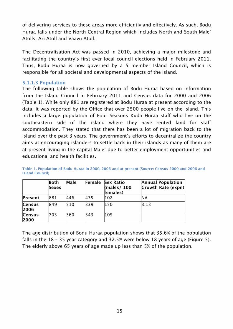
5.1.1.3 PopulationThe following table shows the population of Bodu Huraa based on information from the Island Council in February 2011 and Census data for 2000 and 2006 (Table 1). While only 881 are registered at Bodu Huraa at present according to the data, it was reported by the Office that over 2500 people live on the island. This includes a large population of Four Seasons Kuda Huraa staff who live on the southeastern side of the island where they have rented land for staff accommodation. They stated that there has been a lot of migration back to the island over the past 3 years. The government’s efforts to decentralize the country aims at encouraging islanders to settle back in their islands as many of them are at present living in the capital Male’ due to better employment opportunities and educational and health facilities.
Table 1. Population of Bodu Huraa in 2000, 2006 and at present (Source: Census 2000 and 2006 and Island Council)
Both Sexes
Male Female Sex Ratio(males/ 100 females)
Annual Population Growth Rate (expn)
Present 881 446 435 102 NACensus 2006
849 510 339 150 3.13
Census 2000
703 360 343 105
The age distribution of Bodu Huraa population shows that 35.6% of the population falls in the 18 – 35 year category and 32.5% were below 18 years of age (Figure 5). The elderly above 65 years of age made up less than 5% of the population.

16
Figure 5. Population of Bodu Huraa by gender and age distribution in 2011 (Source: Island Council)
The expatriate population of Maldives is estimated to be around 70,000 with a rising trend. There is an expatriate community of 143 people, 136 of them male and only 07 females on Bodu Huraa (Table 2). Most of the men were working in the construction industry while the women were employed in the health and education sectors. The large expatriate labour force on small islands create economic consequences such as foreign currently outflow from the country and social issues arising from the differences in culture.
Table 2. Expatriate population on Bodu Huraa (Source: Island Council)
Employed sector Male Female TotalEducation 4 4 8Health 1 2 3Construction 115 0 115Labourer 16 1 17Total 136 7 143
There are 216 households on the island, out of which 145 are inhabited and 71 uninhabited. A large area of the island is rented out to the Four Seasons Kuda Huraa for their staff accommodation and more recently to make the tennis courts for the tourists visiting the resort.
5.1.1.4 EmploymentThe Census 2006 data shows that a large percentage of the employed population of Bodu Huraa was working in the hotels and restaurants sector (25.22%) followed

17
by manufacturing (17.32%) and construction (15.35%) sectors (Figure 6). The number of people working in the wholesale and retail trade was 12.28%. Being close to Male’ and numerous resorts, the island is regularly visited by tourists. This is reflected in the number of people working in the hotels and restaurants and also in retail trade.
There are 57 retail shops on the island at present and these include 11 corner stores selling goods to locals as well as 46 tourist souvenir shops. The high percentage working in the manufacturing and construction sector is attributed to those that are working on the construction sites of the adjacent Four Seasons Resort. There is also a handicraft centre on the island where local souvenirs are produced and sold at the tourist shops. In addition there is a fish processing plant and a few unregistered guesthouses on the island as well.
Sand mining is carried out by a group of 3 people from an area located about 200 feet away from the island allocated for the purpose. They use a small boat to
collect sand and sell it for Rf 5 per sack.Figure 6. Employment structure - Bodu Huraa (Source: Census 2006, www.planning.gov.mv)
5.1.1.5 Educational ServicesThere is at present one public school teaching up to Grade 10 or GCE Ordinary Level and one community-run preschool on the island. All schools are co-educational and the literacy rate is reported to be 93.1 % in the 2006 Census. The State is obliged to provide free education under the Constitution of the Maldives and under Article 36(b) parents are obliged to provide their children with primary and secondary education. As such all school-age children residing on the island
18
attend school and in February 2011 there were 53 girls and 56 boys with a total of 109 children attending school in Bodu Huraa. Many families have moved to the nearby Capital to provide better education for their children. This is reflected in the discrepancy between the number of registered children under the age of 18 (Figure 5) and those that attend the schools in Bodu Huraa.
5.1.1.6 Health ServicesThe island of Bodu Huraa is serviced by a Health Post, the lowest level of health infrastructure provided in the islands. They provide basic services such as a clean environment for delivery and are staffed with a Family Health Worker who provide simple curative and preventive services at the island level. For more complicated ailments, they are expected to visit the Male’ hospitals and clinics which provide better services. At present all Maldivians have health insurance coverage under the newly introduced Aasandha program. There is no pharmacy on the island which makes it very difficult for the islanders to even treat minor ailments.
5.1.1.7 ElectricityElectricity is provided to all households of Bodu Huraa on a 24 hour basis by five generator sets (3 x 100 kW, 1 x 360 kW, 1 x 450 kW) owned by the community. Electricity is significantly expensive and costs Rf3 and Rf6 per unit depending on the level of usage.
5.1.1.8 Water and Sewerage Rainwater is collected on the island to be consumed as drinking water and all households have access to freshwater. A desalinated plant was presented to the island by the Four Seasons Resort Kuda Huraa but it is at present out of order. Traditionally ground water from wells was used on all islands as the primary source of water. Although the ground water is now contaminated due to over-extraction as a result of increasing population the islanders still use it for washing and cleaning purposes.
A sewage treatment plant was gifted by Fourseasons Resort Kuda Huraa and installed on the island in 2008. Approximately 75% of the households are connected to the system.
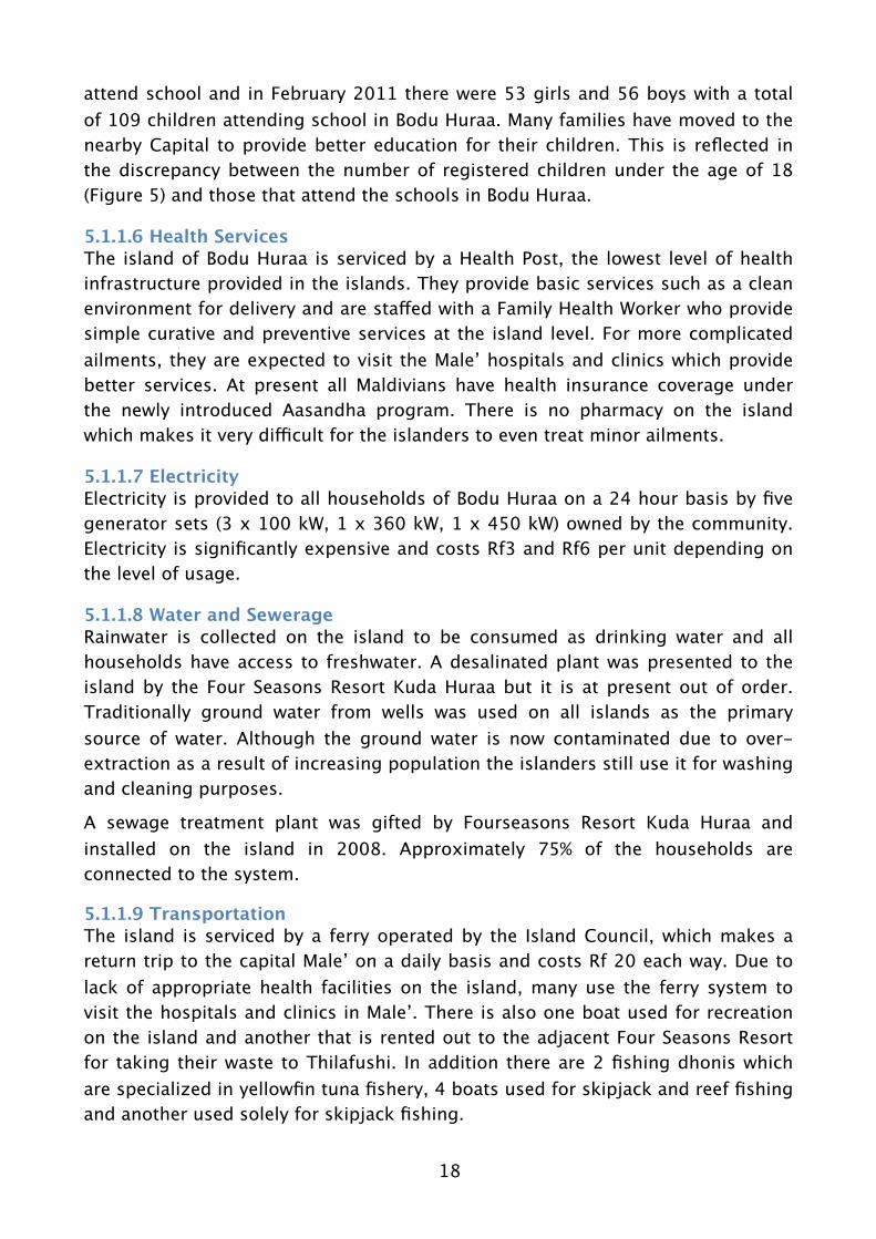
5.1.1.9 TransportationThe island is serviced by a ferry operated by the Island Council, which makes a return trip to the capital Male’ on a daily basis and costs Rf 20 each way. Due to lack of appropriate health facilities on the island, many use the ferry system to visit the hospitals and clinics in Male’. There is also one boat used for recreation on the island and another that is rented out to the adjacent Four Seasons Resort for taking their waste to Thilafushi. In addition there are 2 fishing dhonis which are specialized in yellowfin tuna fishery, 4 boats used for skipjack and reef fishing and another used solely for skipjack fishing.

19
5.1.1.10 Other infrastructureThere is a harbour on the western side of the island which provides shelter to the boats owned by the islanders as well as those that seek shelter during bad weather. A few guesthouses are now found on the island which are operated by the local people. Guesthouse operation was only recently authorized and is proving to be popular among tourists visiting the country as it provides a cheaper alternative to the more luxurious and expensive resorts. It also provides them with a chance to interact with the local people and get the local experience.
There are 4 mosques on the island used for prayers by men and women. As such, there are 2 government owned mosques and 2 publicly owned mosques with two exclusively for men and the other two for women respectively. In addition there is an old historical mosque on the island which attracts tourists during their visit to the island.
There are 3 Clubs/Youth Associations on the island. They are registered groups that organize different activities to assist in community issues by raising funds for such purposes.
The island is well connected nationally and internationally through mobile phones and internet as well as cable television. Most people own a mobile phone and have a cable TV connection on the island.
5.1.1.11 Environmental IssuesThe greatest environmental challenge on Bodu Huraa is management of waste produced on the island. An Island Waste Management Centre (IWMC) was built on the island following the tsunami during the recovery program. However, the Centre is not used appropriately due to lack of final disposal from the island. All non-biodegradable waste produced on the island is accumulated near the IWMC and once or twice a year, when transportation of this waste to Thilafushi is facilitated by a sponsorship from an individual or an association on the island, it is cleared from the island. At present discussions are ongoing between the Island Council and the adjacent Four Seasons Resort Kuda Huraa to implement a system to dispose of non-biodegradable waste on a regular basis.
Another major issue on the island is erosion and many attempts have been made to minimize loss of land on Bodu Huraa. Erosion is exacerbated due to unplanned coastal modification of the shoreline and therefore becomes costly to manage.
There is a small mangrove system found on the western side of the island of Bodu Huraa. While it covers an area of about 9 hectares it makes up about half of the natural island (Saleem, 2004). The mangrove vegetation is found in a bay, which is subjected to daily tidal flushing and “island-like” vegetation clumps are also found within this bay. Ten species of plants are found in this mangrove including four true mangrove species and six mangrove associate species. Several species

20
of birds including some protected species, fish, crabs, shrimps and 3 species of reptiles have been recorded from the Huraa mangroves.
The Huraa Mangrove Area was declared a protected area on the 14th of June 2006 under the directive number 174-AB1/2006/13. While a Conservation Management Plan has been developed for the site (Saleem, 2004), no management measures have been implemented to date. However, it should be noted that the area is kept clean and waste dumping into the mangroves has been discontinued.
5.1.2 Himmafushi
5.1.2.1 LocationHimmafushi is located at 4o 18’ 33” N and 73o 34’ 15” E in North Male’ or Kaafu Atoll (Figure 1). It lies 15 km north east of the capital Male’ and 13 km north of the Ibrahim Nasir International Airport. The island is approximately 900 m long and 970 m wide on the northern side of the island and 450 m wide on the southern side. The area of Himmafushi is 33.4 ha and the island has been extensively reclaimed giving it a peculiar shape (Figure 7) Himmafushi shares the reef with Soneva Gili Resort and Paradise Island Resort and Spa.
Figure 7. Aerial photo of Himmafushi in 2011
5.1.2.2 Administrative StructureLike Bodu Huraa, Himmafushi falls under the North Central Region which includes North and South Male’ Atolls, Ari Atoll and Vaavu Atoll. Under the Decentralisation

21
Act which was passed in 2010, local council elections were held in Himmafushi in February 2011. Thus, the island is now governed by a 5 member Island Council, which is responsible for all societal and developmental aspects of the island.
5.1.2.3 PopulationThe following table shows the population of Himmafushi based on information provided by the Island Council in February 2011 and Census data for 2000 and 2006 (Table 3). There doesn’t seem to be any inward migration to Himmafushi in the past 5 years. In fact, the population has decreased slightly. However, the main trend that is observed is the increased balance in male:female ratio. While the Census 2006 shows that there were 188 males for each 100 females, this number has decreased to 117 at present. The high numbers of males is related to the presence of the residential drug rehabilitation facility and a low security prison on the island. There are only male inmates in the prison and only a small population of females in the rehabilitation facility. The significant difference in the number of males between the Census 2006 and present could be attributed to the large number of inmates released from the low security prison in 2010 under the “2nd Chance” program initiated by the Nasheed government. The main prison of Maldives was in Himmafushi but was moved to Maafushi in 1999 due to arson in the prison.
Table 3. Population of Himmafushi in 2000, 2006 and at present (Source: Census 2000 and 2006 and Island Council)
Both Sexes
Male Female Sex Ratio(males/ 100 females)
Annual Population Growth Rate (expn)
Present 936 506 430 117 NACensus 2006
1007 657 350 188 2.28
Census 2000
878 525 353 149
The age distribution of Himmafushi population shows that 33 % of the population falls in the 18 – 35 year category and about 40% were below 18 years of age (Figure 8). The elderly above 65 years of age made up less than 5% of the population.

22
Figure 8. Population of Himmafushi by gender and age distribution in 2011 (Source: Island Council)
Himmafushi has an expatriate population of 156, with 139 males and 17 females. (Table 4). Most of the men were working as labourers at the boatyard and the prison and rehabilitation facilities on the island while the women were employed in the health and education sectors. The high percentage of expatriate population on small islands creates many social and economic issues due to differences in culture and outflow of foreign currency from the country.
Table 4. Expatriate population on Himmafushi (Source: Island Council)
Employed sector Male Female TotalEducation 7 3 10Health 1 4 5Construction 16 0 16Agriculture 6 0 6Labourer 81 0 81Other 28 10 38Total 139 10 156
There are 263 plots of land that have been allocated for different purposes on the island of Himmafushi. Of these 221 has been registered as households and 42 leased out for industrial purposes.

23
5.1.2.4 EmploymentThe Census 2006 data shows that a large percentage of the employed population on Himmafushi was working in the health and social work sector (31.26%) followed by manufacturing (28.05%) (Figure 9). The high percentage of people working in the health and social work sector is attributed to the presence of the rehabilitation facility and the prison on the island. The manufacturing sector is also very significant on the island as Himmafushi has one of the few and busiest boatyards in the atoll. The number of people working in the wholesale and retail trade was 9.42%. There are 39 retails shops on Himmafushi at present, about 10 of them selling souvenirs to visiting tourists from nearby resorts. The information provided by the Island Council gives a prioritized list of employment sectors:
1. Civil Service – mostly wardens at Rehabilitation Centre and Low Security Prison
2. Tourism related business3. Fish processing plants4. Reef fishery5. Self employment
Figure 9. Employment structure - Himmafushi (Source: Census 2006, www.planning.gov.mv)
1. Educational ServicesAt present there are two schools on Himmafushi, one public school teaching up to Grade 10 and a preschool owned by the community that teaches up to upper kindergarten. All schools are co-educational and the literacy rate is reported to be 91.6 % in the 2006 Census. All school-age children are obliged to attend school by law and at time of reporting there were 115 girls and 128 boys with a total of 243 attending school on the island. Many of the families have moved to the capital Male’ for better educational and employment facilities.

24
5.1.2.6 Health ServicesThere is only a government owned Health Centre and one community owned pharmacy on the island. They provide basic services such as a clean environment for delivery and are staffed with a Family Health Worker who provides simple curative and preventive services at the island level. For more complicated ailments, they are expected to visit the Male’ hospitals and clinics which provide better services. At present all Maldivians have health insurance coverage under the newly introduced Aasandha program.
5.1.2.7 ElectricityThe State Electric Company (STELCO) provides electricity to Himmafushi. It is available 24 hours a day and is serviced by 4 generators of 400 kW each. The tariffs are quite expensive and the local people are required to pay at the following rates:
• 1-100 Units – Rf2.25 per unit• 101-200 Units – Rf3.50 per unit• Over 201 Units – Rf 3.75 per unit
5.1.2.8 Water and Sewerage Rainwater is collected on the island to be consumed as drinking water and 90% of households have access to clean potable water. There are also community tanks which collect rainwater for the use of everyone on the island. There is no sewage treatment on the island and untreated sewage is pumped out to the island reef, impacting the health of the reef system.
5.1.2.9 TransportationA ferry operates between Himmafushi and Male’ which enables the islanders to go to the capital for buying goods and procuring health and other goods and services. According to the information provided by the Island Council, there are 10 boats of about 15 feet each that are used for reef fishing. Land transport includes 13 pick up trucks. While the number of motor bikes were not reported, several bikes were observed during the island visit.
5.1.2.10 Other infrastructureThe island has a harbour where boats seek shelter during the night and bad weather conditions. The island also has two privately owned boatyards and slipways making it an important location for boat maintenance in the region. Ninety percent of the profits go to the community through salaries. There is also a group of sand miners that collect about 200 sacks of sand each month.
There are 2 mosques on the island, one built by the government and the other by an individual from the community. Both are used for prayers by men. The women are expected to pray at home.

25
The island is well connected nationally and internationally through mobile phones and internet as well as cable television. Most people own a mobile phone and have a cable TV connection at home.
5.1.2.11 Environment IssuesAs in many Maldivian islands, erosion is a major challenge facing Himmafushi Island. Erosion is reported to be severe and could be partly related to the coastal modification of the shoreline over time. Due to overcrowding and a need for shelter for boats and easy access to the island, the island has been reclaimed and a harbour built on the western side of the island. These modifications have changed the water current patterns resulting in erosion of other areas of the island.
Waste management is another issue that arises with lack of space on small islands. Due to the geographical spread of the islands, it becomes a challenge to take non-biodegradable waste from the island to the municipal landfill which is situated about 20 km from the island. Thus, without a proper waste management system, this waste piles up on the island resulting in unhygienic conditions, increasing pest problems and makes the island aesthetically unpleasant.
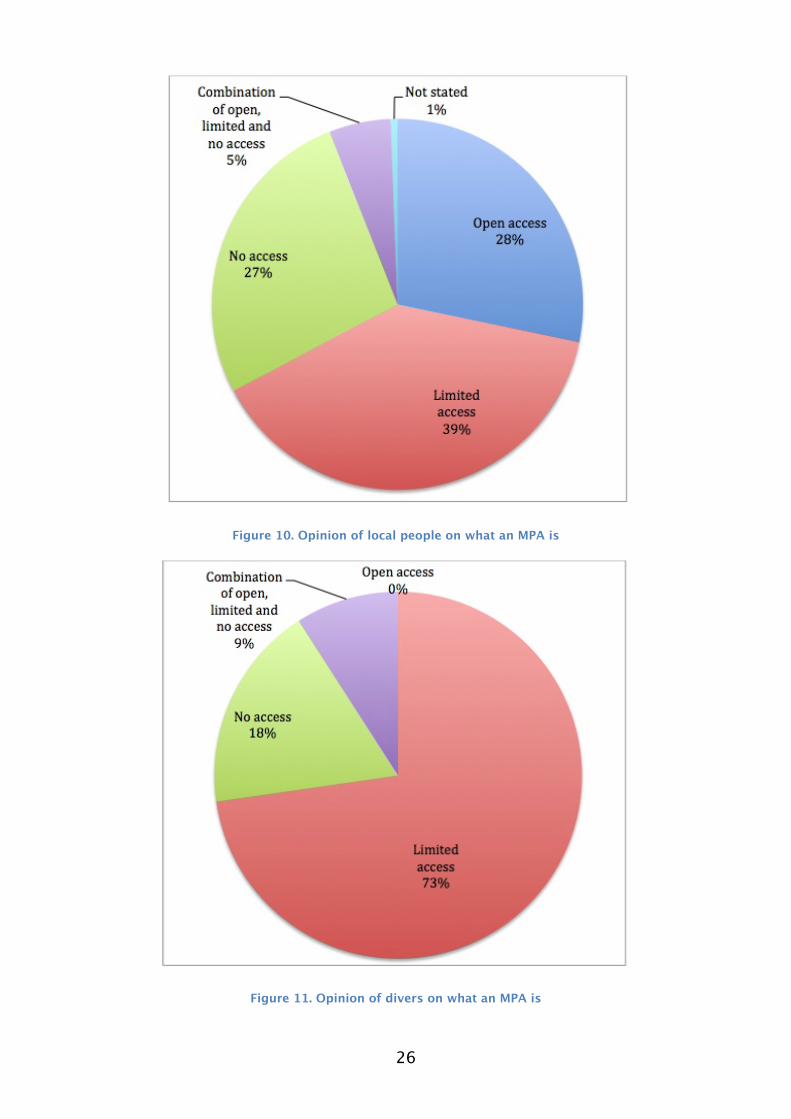
5.2 Perception SurveyThe results of the local perceptions on protected areas in the Maldives survey showed that the opinion of what a Marine Protected Area (MPA) varied greatly among the respondents. They were asked what an MPA was in their opinion and the largest percentage stated that they were areas with limited access (Figure 10). This category was followed by about similar numbers saying they were either open access or areas with no access respectively. This shows that while most of them have an idea of what protected areas mean, about a quarter of the respondents did not understand that they were areas that provided some level of protection to the environment.
When posed the same question to the Resort Dive Schools, the response was very different (Figure 11). About three quarters of the respondents believed that they were areas with limited access and none responded that they were areas with open access to resources. The percentage of divers that understood MPAs as “no access” area was lower than among the local people.
This shows that much work is required in the Maldives to spread awareness on MPAs. Since the country relies so heavily on tourism which is based on the marine environment, it is important that both the beneficiaries and the users understand the setup and benefits of MPAs.
26
Figure 10. Opinion of local people on what an MPA is
Figure 11. Opinion of divers on what an MPA is
27
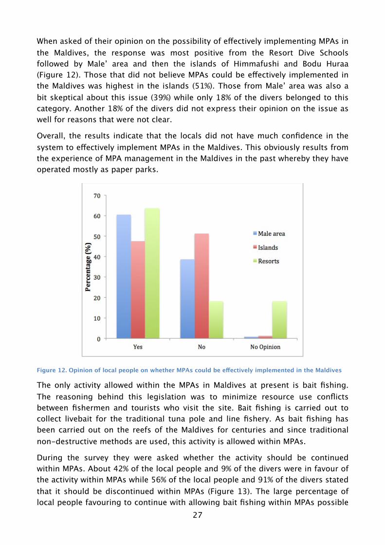
When asked of their opinion on the possibility of effectively implementing MPAs in the Maldives, the response was most positive from the Resort Dive Schools followed by Male’ area and then the islands of Himmafushi and Bodu Huraa (Figure 12). Those that did not believe MPAs could be effectively implemented in the Maldives was highest in the islands (51%). Those from Male’ area was also a bit skeptical about this issue (39%) while only 18% of the divers belonged to this category. Another 18% of the divers did not express their opinion on the issue as well for reasons that were not clear.
Overall, the results indicate that the locals did not have much confidence in the system to effectively implement MPAs in the Maldives. This obviously results from the experience of MPA management in the Maldives in the past whereby they have operated mostly as paper parks.
Figure 12. Opinion of local people on whether MPAs could be effectively implemented in the Maldives
The only activity allowed within the MPAs in Maldives at present is bait fishing. The reasoning behind this legislation was to minimize resource use conflicts between fishermen and tourists who visit the site. Bait fishing is carried out to collect livebait for the traditional tuna pole and line fishery. As bait fishing has been carried out on the reefs of the Maldives for centuries and since traditional non-destructive methods are used, this activity is allowed within MPAs.
During the survey they were asked whether the activity should be continued within MPAs. About 42% of the local people and 9% of the divers were in favour of the activity within MPAs while 56% of the local people and 91% of the divers stated that it should be discontinued within MPAs (Figure 13). The large percentage of local people favouring to continue with allowing bait fishing within MPAs possible

28
show the respect they have for the fishing industry and the traditional nature of the activity. Divers of course would favour total protection of species as their interaction with the MPAs is more passive.
Figure 13. Should bait fishing be continued within MPAs
They were also asked if other extractive activities should be allowed in MPAs and a higher percentage of local people (71%) disagreed with the statement while 28% thought it should be allowed (Figure 14).
Figure 14. Should extractive activities be allowed within MPAs
Among the divers 18% agreed that extractive activities should be allowed within MPAs while 82% disagreed with the activity. The responses to the questions on extraction of resources from the MPAs show that the MPA regulations require a review, taking into account recent behavioural changes in the society.

29
Figure 15. Awareness of protected status of Banana Reef and Nassimo Thila
About 75% of the local people were not aware of the protected status of Banana Reef and Nassimo Thila while only about a quarter of the divers were not aware of it (Figure 15). This is surprising as the areas have been protected since 1995 and 1999 respectively. This reinforces the need for increased awareness of protected areas among the local people and divers alike in the Maldives.
The respondents were asked to indicate the degree of agreement to the following environmental statements and the graph shows the response:
(A) Coral reefs are important for protecting land from storm waves(B) The seagrass beds provide food to turtles(C) Reefs and lagoon provide us with beautiful fish and shells(D) Mangroves are important as nursery grounds for sea animals (E) Coral reefs are important because they are beautiful(F) I want the future generations to enjoy the mangroves(G) I want the future generations to enjoy the coral reefs(H) Fishing should be restricted in certain areas even if no one ever fishes in those areas just to allow the fish and corals to grow(I) We should restrict development in some coastal areas so that future generations will be able to have natural environments
Overall there was agreement with all of the statements among both groups although it should be noted that the agreement was greater among the divers (Figure 16; Figure 17). Among the local respondents highest percentage of disagreement was with the statements E, H and I, that coral reefs were important due to aesthetic reasons, that fishing should be restricted in some areas and coastal development should be restricted for the enjoyment of future generations respectively. Among the divers, disagreement was only expressed for statements

30
B and C which are that seagrass beds provide food to turtles and reefs and lagoons provide us with beautiful fish and shells.
The responses to the statements show the importance of the environment and its biodiversity to local people as well as divers. However, it should be noted that development, at the expense of environmental degradation, was not favoured by the local people. Also the aesthetic beauty of coral reefs do not seem to be appreciated by the local community most probably due to the low level of interaction with the reefs for recreational purposes.
Figure 16. Agreement with environment related statements for local people
Figure 17. Agreement with environment related statements for resorts

31
The respondents were also asked of their opinion on the barriers to effective implementation of MPA management and the following graph shows the response (Figure 18). As more than one option could be ticked, the percentages were calculated independently for each category. Among both groups lack of awareness about benefits of MPAs was seen as the most significant barrier to effective implementation of management measures (Local people: 48%; Resorts: 64%). The divers’ response also rated lack of will from local authorities at the same level (64%) while local response found lack of will from central government as more important. Financial constraints was not seen as an important barrier to management by local people while the resorts expressed more concern for this issue. The same issues appear to be significant throughout the survey response, showing the importance of increasing awareness of MPAs in the Maldives.
Figure 18. Barriers to effective management of MPAs
When asked of their opinion on leasing MPA management to private parties the response was contrasting between the local people and the resorts (Figure 19). Majority of local respondents stated that it was a good idea that will make management more effective, while a third of them did not agree with the proposition. When the results were separated into response from Male’ area (Male’, Vilingili and Hulhumale’) and the islands (Huraa and Himmafushi), the agreement was more from the islands (68%) than from Male’ area (50%). Most respondents from the Resorts were not in favour of leasing MPAs to private parties and believed that the government should take the responsibility for managing them. This shows the differences in perception on the role of management authorities in managing MPAs.

32
Figure 19. Should MPAs be leased out to private parties for management?

33
6. ConclusionSocmon South Asia provides a comprehensive guideline to carrying out socioeconomic monitoring in the Asian context. Often the settings in this part of the world are very different from the developed world, with poverty and livelihoods issues deeply intertwined with natural resources. Thus, it is very important that these resources are well managed to reap the benefits by the community, at the same time providing environmental conservation values.
Maldives is a country based on the pristine nature of its marine environment. The economy of the country, the livelihoods of the people and the way of life is based on it. From the island profiles of Himmafushi and Bodu Huraa, it is evident that the livelihoods rely heavily on the marine environment and related industries such as tourism and fisheries. Thus the importance of appropriately managing the natural resources is crucial to the development of the society.
As protected areas are used as a tool for managing natural resources, it is applicable both in the tourism and fisheries sense. If properly implemented, they can aid in conflict resolution among different user groups that are using the same resources. Thus, protected areas could act to deliver these outcomes in the Maldives if they were implemented and managed effectively.
From the perceptions study it is evident that Nassimo Thila and Banana Reef are not effectively managed. Even though they were declared protected in the 1990s, many people including some divers working in the Maldives are not aware of the status. Also, the most important barrier to effective management was seen as lack of awareness on the benefits of protected areas. This shows the importance of increasing awareness among the local community on the existing protected areas in the Maldives as well as the uses and benefits to the community.
The survey results also showed that the existing protected area management guidelines needs to be reviewed. While at present bait fishing is the only extractive activity allowed in protected areas, majority of the respondents were in favour of discontinuing this activity within those areas. Thus, MPA management will highly benefit from a review of existing MPA management guidelines. Involvement of communities in MPA management is very important and their willingness to collaborate in such efforts was also seen from the survey. Most of the local people were in agreement with leasing the protected areas to private
34
parties for management. Of course many expressed the need for the government to closely monitor the activities and to lease them out under a management plan.
The island profiles of both Himmafushi and Bodu Huraa shows that both islands rely heavily on the tourism industry for their livelihoods. The influx of visiting tourists from the nearby resorts are an asset to the islanders. At present, the islanders are in need of livelihood diversification which can include the MPAs. If MPAs can be leased out to the Island Councils or the community, they can organize day trips to the MPAs, establishing alternative income generating activities. For Bodu Huraa inhabitants, the Huraa Mangroves is a significant asset in addition to Nassimo Thila and Banana Reef. They will of course require guidance and funding to initiate such activities.
35
7. RecommendationsThe following recommendations are proposed as a result of this study:
1. Review existing MPA management guidelines focused on activities allowed within protected areas.
2. Strengthen management of MPAs in the Maldives by developing management plans for individual sites.
3. Increase awareness among the local and diving community about MPAs in general and benefits of MPAs in particular.
4. Explore the possibility of leasing out MPA management to private parties with involvement from the local communities. The government should play a supervision role in such a setting to ensure overall guidelines are followed.

36
8. ReferencesEmerton, L, Baig, S. and M. Saleem. (2009). Valuing Biodiversity: The economic
case for biodiversity conservation in the Maldives. AEC Project, Ministry of Housing, Transport and Environment, Government of Maldives and UNDP.
Hoon, V., Sriskanthan, G., Townsley, P., Cattermoul, B., Bunce, L. and B. Pomeroy. (2008). Socioeconomic monitoring guidelines for coastal managers in South Asia : SOCMON South Asia. IUCN, Gland, Switzerland and Colombo, Sri Lanka/ CORDIO, Kalmar, Sweden.
Hunter, D. (1996). Natural resources and community participation in their management: An atoll perspective. Rural Society Journal Vol 6:3. Pp 19-27.
MHE. (2010). Request for proposals: Management of Marine Protected Areas in Male’ Atoll. MHE, Male’, Maldives.
ICRI. (2010). Climate change and coral reefs: Consequences of inaction. International Coral Reef Initiative and Global Coral Reef Monitoring Network. Brochure.
Naseer, A. and B. G. Hatcher. (2004). Inventory of the Maldives' coral reefs using morphometrics generated from Landsat ETM+ imagery. Coral Reefs 23: 161-168.
Saleem, A. (2004). Conservation Management Plan for the mangrove habitat at Huraa Island, the Maldives. EPA, Male’, Maldives.
37
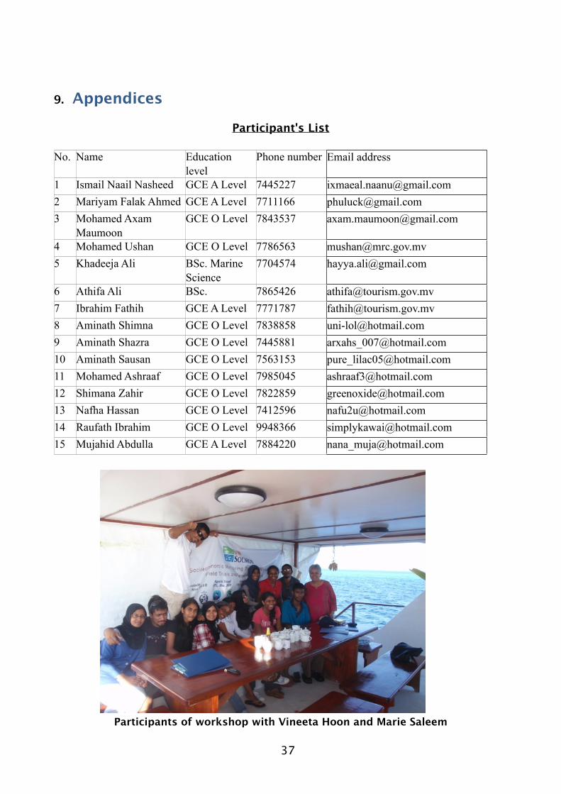
9. Appendices
Participant's List
No. Name Education level
Phone number Email address
1 Ismail Naail Nasheed GCE A Level 7445227 [email protected] Mariyam Falak Ahmed GCE A Level 7711166 [email protected] Mohamed Axam
MaumoonGCE O Level 7843537 [email protected]
4 Mohamed Ushan GCE O Level 7786563 [email protected] Khadeeja Ali BSc. Marine
Science7704574 [email protected]
6 Athifa Ali BSc. 7865426 [email protected] Ibrahim Fathih GCE A Level 7771787 [email protected] Aminath Shimna GCE O Level 7838858 [email protected] Aminath Shazra GCE O Level 7445881 [email protected] Aminath Sausan GCE O Level 7563153 [email protected] Mohamed Ashraaf GCE O Level 7985045 [email protected] Shimana Zahir GCE O Level 7822859 [email protected] Nafha Hassan GCE O Level 7412596 [email protected] Raufath Ibrahim GCE O Level 9948366 [email protected] Mujahid Abdulla GCE A Level 7884220 [email protected]
Participants of workshop with Vineeta Hoon and Marie Saleem

38
Questionnaire on Perceptions of Maldivians and Dive Community on Protected Area Management - SOCMON
1. What in your opinion is a protected area is? a. An area that has open access to it's resourcesb. An area that has limited accessc. An area that cannot be accessedd. All of the above
2. What are the benefits of protecting a natural area?a. For you as an individual?b. For the community?
3. Indicate degree of agreement with the following statements using the scale of agree strongly (5), agree (4), neither agree nor disagree (3), disagree (2) and disagree strongly (1).
____ (a) Coral reefs are important for protecting land from storm waves____ (b) The seagrass beds provide food to turtles____ (c) Reefs and lagoon provide us with beautiful fish and shells____ (d) Mangroves are important as nursery grounds for sea animals ____ (e) Coral reefs are important because they are beautiful____ (f) I want the future generations to enjoy the magroves____ (g) I want the future generations to enjoy the coral reefs____ (h) Fishing should be restricted in certain areas even if no one ever fishes in those areas just to allow the fish and corals to grow____ (i) We should restrict development in some coastal areas so that future generations will be able to have natural environments
4. Do you think protected areas can be effectively implemented in the Maldives? Yes/ No
5. Are you aware that Banana Reef (Gaathugiri) is protected under the law? Yes/ No
6. Are you aware that Nassimo Thila (Lankan Thila) is protected under the law? Yes/ No
7. Only bait fishing and non-extractive activities are allowed in these areas: a. Do you think bait fishing should be allowed? Yes/ Nob. Do you think other extractive activities should be allowed? Yes/ No
8. Do you think that the resource use (corals, sand, fish, turtle eggs, mangrove wood etc) should be allowed within a protected area? Yes/ No
9. What in your opinion are the barriers to effective implementation of management?a. Lack of will from local authoritiesb. Lack of will from central governmentc. Lack of awareness about benefits of MPAsd. Lack of awareness about management of MPAse. Financial constraintsf. Other. Please specify ____________________
10.What do you think can be done to facilitate management of these protected areas?
39
11.What is your opinion of leasing MPA management to private parties?
BACKGROUND QUESTIONS 12.Sex: (please tick) Male Female 13.In which of the following age group do you fall? (please tick)Below 15 15-25 26-35 36-45 46-55 Over 55
14.What is your level of Education? (please tick) No formal education Primary education Some Secondary education Completed Secondary education Some University or College/Technical School Completed University
15.What is your profession? ________________
16.We would like to know your approximate annual income? (please tick) Below Rf 50,000 Rf 51,000 – Rf 75,000 Rf 76,000 – 100,000 Rf 101,000 – 125,000 Above 126,000