socio-spatial differentiation and residential …moise/data/books/social/03 race and...
TRANSCRIPT

Geoforum 35 (2004) 157–175
www.elsevier.com/locate/geoforum
Socio-spatial differentiation and residential segregation in Delhi:a question of scale?
V�eronique Dupont *
Institut de Recherche pour le D�eveloppment & Centre for Indian and South Asian Studies, Paris, France
Received 21 November 2001; received in revised form 28 December 2002
Abstract
This paper focuses on the pattern of social-spatial differentiation and segmentation of the metropolitan area of Delhi. The main
objective is to analyse the mechanisms of residential segregation and the factors that explain it both at the micro- and macro-level. In
the context of the Indian society and its caste system traditionally associated with strong social and spatial segregation, we try to
appraise the extent to which the metropolitanization process in Delhi engenders original forms of spatial segmentation or per-
petuates and strengthens the traditional forms of socio-spatial divisions. At the level of the global spatial organization of the urban
agglomeration, our objective is twofold: to analyse the factors that shaped the urban landscape and introduced spatial discontinuity,
from physical barriers to the different historic periods and the impact of town planning; to analyse the residential pattern of different
segments of the urban population, in order to detect whether certain economic and socio-cultural attributes generate a pattern of
segregation. We then pursue a more detailed investigation at the level of a zone, based on the case study of Mayur Vihar–Trilokpuri
in east Delhi. We analyse the residential practices developed by different socio-economic groups, their strategies as regards the
occupation of the geographical and economic space, their tendency to residential clustering that leads to a pattern of social seg-
regation at the level of the neighbourhood. In this perspective, the links between the urban policies at the macro-level and the
individuals’ residential practices at the micro-level are also examined.
� 2003 Elsevier Ltd. All rights reserved.
Keywords: Delhi; Urban development; Town planning; Residential segregation; Socio-spatial differentiation
1. Introduction
This article focuses on the pattern of socio-spatial
differentiation and segmentation of the metropolitan
area of Delhi. The main objective is to analyse the
mechanisms of residential segregation and the factors
that explain it both at the micro- and macro-level, in-
cluding the impact of the residential strategies of the
households as well as the role of the state through urban
policy and planning. In the context of Indian society andits caste system traditionally associated with strong so-
cial and spatial segregation, we shall try to appraise the
extent to which the metropolitanization process in Delhi
engenders original forms of spatial segmentation or
*Address: Cultural Section of the Embassy of France, Centre de
Sciences Humaines (CSH), 2 Aurangzeb Road, 110 011 New Delhi,
India. Fax: +91-11-23-01-84-80.
E-mail address: [email protected] (V. Dupont).
0016-7185/$ - see front matter � 2003 Elsevier Ltd. All rights reserved.
doi:10.1016/j.geoforum.2003.08.003
perpetuates and strengthens the traditional forms of
socio-spatial divisions.At the level of the spatial organization of the urban
agglomeration as a whole, our objective is twofold:
• to analyse the factors that shaped the urban land-
scape and introduced spatial discontinuity, from
physical barriers to the different historic periods and
the impact of town planning;
• to analyse the residential pattern of different segmentsof the urban population, in order to detect whether
certain economic and socio-cultural attributes gener-
ate a pattern of segregation.
We shall then pursue a more detailed investigation at
the level of a zone, based on the case study of Mayur
Vihar and Trilokpuri in east Delhi. We shall analyse the
residential practices developed by different socio-eco-nomic groups, their strategies as regards the occupa-
tion of the geographical and economic space, and
158 V. Dupont / Geoforum 35 (2004) 157–175
their tendency to residential clustering that leads to a
pattern of social segregation inside the neighbourhood.
In this study, the concept of segregation refers to its
empirical form as: ‘‘spatial distinctions among the resi-dential zones of population groups living in the same
[urban] agglomeration’’ (Brun, 1994, p. 22). This socio-
spatial division of the urban area may result from in-
stitutional principles of social organization, or may be
the outcome of individual or collective actions, deliber-
ate or not (Grafmeyer, 1994). This broad and neutral
initial definition will allow us, however, to broach dif-
ferent conceptions of what is called �segregation’: seg-regation as a form of unequal spatial distribution of
population groups in the space; segregation as a process
relying on various mechanisms of residential and social
clustering, filtering, selection and/or exclusion; segrega-
tion as a problem revealing social ostracism and/or
discrimination, relegation, isolation of vulnerable and
underprivileged groups; (Grafmeyer, 1994).
2. Pattern of organization and functional specialization of
the urban space
Studies of Delhi usually stress the strong differentia-tion in the spatial organization of the capital. 1 At a city-
wide level, Delhi appears, indeed, as a city without
spatial continuity, a mosaic of very contrasted sectors.
As it will be shown in this section, the pattern of orga-
nization of the urban space is marked by a series of
factors, including geography and physical barriers, the
different historic periods, from the Mughal rule to the
British rule, the trauma of Partition and the Indepen-dence, and the impact of the independent Government,
through its efforts of town planning and in asserting the
status of Delhi as a capital city. All these factors not
only contributed to shape the urban landscape, but have
also influenced the socio-economic composition of the
population residing in various localities. Endogenous
forces are also to be taken into consideration, con-
forming to the laws of the real-estate market, or to thesearch for a better proximity between place of residence
and place of work; furthermore these forces can work
against the attempts by the Delhi Administration to
regulate the development of the capital.
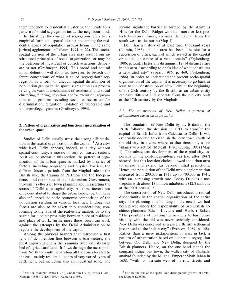
Among the physical barriers that introduce a first
type of demarcation line between urban sectors, the
most important one is the Yamuna river with its large
bed of agricultural land. It flows through the metropolisfrom North to South, separating all the zones located to
the east, mainly residential zones of very varied types of
settlement, but including also an industrial zone. The
1 See for example: Mitra (1970), Sundaram (1978), Brush (1986),
Nagpaul (1988), VHAI (1993), Kumaria (1998).
second significant barrier is formed by the Aravellis
Hills (or the Delhi Ridge) with its––more or less pro-
tected––natural forest, crossing the capital from the
south-west to the north (Map 1).Delhi has a history of at least three thousand years
(Narain, 1986), and its area has been ‘‘the site for a
succession of cities, each of which served as the capital
or citadel or centre of a vast domain’’ (Frykenberg,
1986, p. xxii). Historians distinguish 12–14 distinct cities
in this area, ‘‘according to one’s idea of what constitutes
a separated city’’ (Spear, 1986, p. 469; Frykenberg,
1986). In order to understand the present socio-spatialorganization of the capital, it is necessary to go back at
least to the construction of New Delhi at the beginning
of the 20th century by the British, as an urban entity
radically different and separate from the old city built
at the 17th century by the Mughals.
2.1. The construction of New Delhi: a pattern of
urbanization based on segregation
The foundation of New Delhi by the British in the
1910s followed the decision in 1911 to transfer the
capital of British India from Calcutta to Delhi. It waseventually decided to establish the new town south of
the old city, in a zone where, at that time, only a few
villages were settled (Metcalf, 1986; Gupta, 1998) (Map
1). The subsequent development of the capital city, es-
pecially in the post-independence era (i.e. after 1947)
showed that this location choice allowed the urban area
to spread and extend far beyond initial predictions.
Hence, the population of the Delhi urban agglomerationincreased from 200,000 in 1911 up to 700,000 in 1941,
with an increasing growth rate. Today Delhi is a me-
tropolis with about 13 million inhabitants (12.8 millions
at the 2001 census). 2
The construction of New Delhi introduced a radical
discontinuity in the spatial organization of the entire
city. The planning and building of the new town had
been placed under the responsibility of two British ar-chitect-planners: Edwin Luytens and Herbert Baker.
‘‘The possibility of creating the new city to harmonize
visually with the old was never seriously considered.
New Delhi was conceived as a purely British settlement
juxtaposed to the Indian city’’ (Evenson, 1989, p. 148).
Rather than a mere juxtaposition, it was, in fact, a
pattern of urbanization based on deliberate segregation
between Old Delhi and New Delhi, designed by theBritish planners. Hence, on the one hand stands the
compact indigenous town, the walled city of Shahjah-
anabad founded by the Mughal Emperor Shah Jahan in
1638, ‘‘with its intricate web of narrow streets and
2 For an analysis of the spatial and demographic growth of Delhi,
see Dupont (2000b).

UTTAR
PRADESH
HARYANA
N
0 5 km
Tughlaqabad
V. Dupont - LCA, Bondy - IRD
Digitized map:UMR ESPACE, Montpellier.
Sources: Census of India 1991, District Census Handbook, Delhi, Directorate of Census Operation, Delhi. Slum & Jhuggi Jhompri Department, Municipal Corporation of Delhi, 1990.
Yam
una
river
Model Town
Rohini
DelhiUniversity
Civil Lines
YamunaVihar
Nehru Place
Okhla
SaketMehrauli
NehruUniversity
SafdarjangAerodromeDhaula
Kuan
Airport
Janakpuri
RajouriGarden Pusa
Institute
PresidentEstate
Nizamuddin
LakshmiNagar
Shahdara
Mayur Vihar
R.K. Puram
Punjabi Bagh
Karol BaghOLD
DELHI
NEW DELHI
CANTONMENT
Trilokpuri
Sabir Ali, Slums within Slums: a study of resettlement colonies in Delhi, New Delhi: Council for Social Development, 1990.
Squatter Settlements
Resettlement Colonies
Delhi Ridge
Study Area
Map 1. Delhi urban agglomeration: some elements of differentiation of the urban space––the old and the new city, squatter settlements and
resettlement colonies (1990) (Ali, 1990).
V. Dupont / Geoforum 35 (2004) 157–175 159
densely packed buildings’’ (Evenson, 1989, p. 148). 3 Onthe other hand, separated from the former by a large
3 On the original morphology of the Mughal city and its evolution
till the mid-20th century, see: Navqi (1986), Blake (1986), Noe (1986)
in Frykenberg (1986); Gupta (1998). It is worth noticing here that,
before the Mutiny of 1857, ‘‘the British accepted the walled city, and
did not segregate themselves in a �Civil Lines’. [. . .] It was this fact––that the British lived and built in �Indian territory’––that made Delhi
before 1857 different from the Presidency towns, where there was racial
segregation.’’ (Gupta, 1998, pp. 15–16). A Civil Lines for the exclusive
residence of the European developed after 1857, in the northern
suburbs, ‘‘once it was decided the European should live away from the
�native city’. [. . .] it was separated from the city by the cordon sanitaire
of the gardens’’ (Gupta, 1998, p. 58).
strip of land cleared and landscaped, lies the new colo-nial town, the spread garden city with its geometric plan,
its large roads and vast dimensions. Furthermore, ac-
cording to Gupta (1998, p. 181) it was ‘‘the combined
fear of the old town encroaching on and spoiling the
symmetry of the new, and of the �Indian town’ (the term
used now for Delhi city, with a patently racist overtone)
polluting the imperial one [that] led to the first serious
attempt at long-term town planning for Delhi’s urbanarea’’.
This opposition between Old Delhi and New Delhi
lingered on after the Independence of the country in
1947. It remains till today as an evident element of
differentiation in the urban landscape as well as the

4 Source of data: Ministry of Rehabilitation, Annual Report on
Evacuation, Relief and Rehabilitation of Refugees, 1954–1955 (quoted
in Datta, 1986).5 For a recent and synthetic presentation of the typology of various
housing estates in Delhi, see Misra et al. (1998).
160 V. Dupont / Geoforum 35 (2004) 157–175
socio-spatial organization of the capital. The figures of
population densities illustrate clearly the contrast be-
tween the old and the new city: in 1991 (as per the cen-
sus) the population density reached 616 inhabitants perhectare in the walled city (which covers an area of al-
most 600 ha); whereas in the area corresponding to the
town of New Delhi planned by the British, the popula-
tion density was only 70 inhabitants per hectare (for an
average density of 135 in the entire urban agglomera-
tion).
The opposition between the old and the new city is
also a recurrent theme in publications about the Indiancapital and its ecological pattern. Among others, Mitra
concluded in 1970: ‘‘The problem of Delhi as a capital
city today is a problem of integration’’ (1970: 48). More
than twenty years later, this dual structure is still
prominent, and directly inspired the title of a publica-
tion: ‘‘Delhi: the tale of two cities’’ (VHAI, 1993).
2.2. Urban planning, types of settlement and discontinuity
in the urban landscape
The spatial organization of Delhi is not only marked
by the city’s different historic periods, but also by post-
independence urban planning as well as endogenousforces. Beyond the duality between Old and New Delhi,
some authors emphasize a more complex internal
structure, including ‘‘several contrasting cities or urban
areas’’ (Pugh, 1990, p. 198; Sundaram, 1978). With
reference to the various American ecological models of
cities, Nagpaul, 1988, p. 187 identifies the pattern of
multiple nuclei development as the most relevant model
to explain the urban configuration of Delhi.The various modes of production of the built up area,
and at the outset the state intervention, are directly re-
flected in the urban landscape. Delhi is the Indian city
where new ideas of town planning were launched after
the Independence, and where the first Master Plan was
elaborated and implemented since 1962 (Jain, 1990).
Yet, although on the one hand urban land-use and land
development was controlled by the administration, andnew constructions submitted to numerous regulations,
on the other hand, a large part of the urbanization
process has taken place in an unplanned and informal
way. Thus, the pattern of urban development and spa-
tial organization is the outcome of the relationship
between planning attempts made by the Delhi Devel-
opment Authority (the central administration in charge
of the implementation of the Master Plan and of landdevelopment) and private initiatives and responses.
The first housing programme launched in the Indian
capital by the newly independent government aimed to
face the urgency of thousands of emigrants from Paki-
stan who sought refuge in Delhi at the time of the par-
tition of the country. Thus, in 1947 and just after, Delhi,
whose population was about 900,000 at the time, had to
receive 495,000 refugees from western Punjab and
Sindh, while 329,000 Muslims left the capital and mi-
grated to Pakistan. 4 Many refugees’ rehabilitation col-
onies were subsequently constructed during the late1940s and early 1950s (Rao and Desai, 1965; Datta,
1986).
Since the early 1950s, the government also built
housing estates for its employees who represent a very
significant share of the working population in a national
capital city like Delhi. Many such residential estates
(locally called �colonies’) were constructed in the
southern part of the town; they have engendered apattern of residential segregation, not only between the
government employees and other workers, but also
among the government employees themselves since they
have been supplied with different categories of housing
according to their official status and range of income.
This specific feature of the urban landscape, and its
consequences in terms of segregation along socio-eco-
nomic lines, has been underlined already in studies onDelhi (Sundaram, 1978, p. 121; Nagpaul, 1988, p. 188,
and even qualified as ‘‘salaried apartheid’’ by Mitra
(1970, also quoted by Nagpaul, 1998, p. 188). This
pattern of residential segregation could be interpreted as
a reproduction of the residential pattern established by
the British colonial administration in their planning of
New Delhi, which ‘‘reflected the civil service hierarchy,
with upper-level employees segregated from lower-levelemployees, and the British separated from the Indians’’
(Evenson, 1989, p. 150). The most significant element of
this socio-spatial hierarchy was the distance between the
place of residence and the seat of power (the Viceregal
Palace, converted into the Rashtrapati Bhawan––the
Presidential Palace––in the post-Independence capital).
From another viewpoint, the spatial organisation of
housing estates built for government employees afterIndependence can be read as a revival of the traditional
pattern of spatial and residential segregation based on
caste origin, and applied here to the rank and status in
the administrative service.
The Delhi Development Authority has played a direct
role in the urban development of the capital through its
large-scale acquisition of agricultural land geared to-
wards the implementation of various housing pro-grammes: 5 the construction of flats for sale to private
households of different income groups (locally known as
�DDA flats’); the development of land and the allotment
of plots on a 99 year lease-hold basis to private house-
holds and co-operative group housing societies; the
servicing and allotment of land for the resettlement of

V. Dupont / Geoforum 35 (2004) 157–175 161
slum dwellers and squatters evicted from central areas of
the city. This last policy which resorts to coercive mea-
sures including the demolition of slum and squatter
settlements was pursued most actively during the�Emergency’ (1975–1977) during which time about
152,300 families 6 were forcibly evicted and sent to �re-settlement colonies’, all located––at that time––on the
urban outskirts (Map 1). As it will be illustrated with the
case study of the Mayur Vihar–Trilokpuri zone, each of
these types of housing estate not only presents distinct
architectural and urbanistic features, but also tends to
house specific socio-economic groups of the urbanpopulation.
The process of urban expansion entailed the annex-
ation of agricultural land. More than one hundred
original villages that were absorbed in the urban ag-
glomeration can be identified, 7 and many of them still
appear like enclaves within planned areas (Lewis and
Lewis, 1997). There is a marked discontinuity in the
urban fabric between these urbanized villages charac-terised by their vernacular architecture and their organic
street pattern, and the planned housing estates that
surround them. Furthermore, these two categories of
urban space are submitted to different sets of regula-
tions, hence exacerbating this contrast in development
pattern.
Public housing policies have, however, failed to re-
spond to the demand of large sections of the urbanpopulation, in particular the lower-middle classes and
the poor who have had to resort to the informal housing
sector. Hence, the proliferation of �unauthorized colo-
nies’ in the urban–rural fringe on agricultural land not
meant for urbanization, according to the stipulations of
the Delhi Master Plan. These estates were developed by
unscrupulous entrepreneurs who indulged in illegal sub-
divisioning and selling of unserviced land previouslypurchased from agriculturists. The attitude of the Delhi
Development Authority oscillates from laisser-faire to a
posteriori regularisation, without excluding selective
demolition of unauthorised constructions. In addition to
nearly 800 unauthorised colonies that were regularised in
the sixties and seventies (Banerjee, 1994), another 1300
unauthorised colonies have come up in the following two
decades (Government of National Capital Territory ofDelhi, 1996, p. 11). 8 In 1998, the population of this new
lot was roughly estimated at almost 3 millions, 9 which
6 Source of data: Delhi Development Authority (see Jain, 1990,
p. 173).7 In 1990, the Delhi Development Authority identified 106 urban
villages (DDA, 1990, p. 7). For a longitudinal perspective over the 20th
century, see Diwakar and Quresh (1993).8 This figure is quoted for the year 1995; it includes 1071 colonies
considered for regularisation under the current proposed policy.9 Estimation provided by Common Cause, a citizens’ association
that took the matter of unauthorised colonies to the Delhi High Court,
against their regularisation.
would amount to one fourth of the total population of
the capital city.
As for the poorer sections of the urban population,
they are relegated to squatter settlements and precari-ous housing (locally known as jhuggi-jhonpri), which
have also continued to proliferate despite �slum clear-
ance’ and resettlement programmes. In 1999, it was
estimated that about 600,000 families lived in a thou-
sand or so �jhuggi-jhonpri clusters’ which varied in size
from a dozen dwelling units to 12,000. 10 This figure
corresponds to about 3 million persons or 25% of the
total population of Delhi. The population density in thebig clusters may be very high owing to the cramming
together of families in one-room huts, the frequent
addition of one floor on the reinforced structures, and
very narrow lanes. Although the largest clusters are
generally located in the suburban areas, squatter set-
tlements are found in all sections of the capital, occu-
pying not only vacant land on the urban fringe (at the
time of their emergence), but also all the interstices ofthe urban fabric wherever there is vacant land and
where surveillance by the legal authorities is limited
(Map 1). 11
2.3. Functional specialization of the urban space
A mixed land-use pattern, with a combination of
residential use and economic activities, is generally ac-
knowledged as a typical feature of traditional Indian
cities that has partly persisted in the post-independence
period (Brush, 1962). Mixed land-use was equally foundin Shahjahanabad during the Mughal period (1638–
1803) (Navqi, 1986; Blake, 1986). This pattern is still
prevailing in the Old City of Delhi, which combines
extremely high population densities and a remarkable
concentration of commercial and small-scale industrial
activities (Mehra, 1979). The association of residential
use with commercial and small-scale manufacturing
activities is also observed in the urbanized villages, andin informal types of settlements: in the unauthorized
colonies of the urban periphery, as well as––to some
extent––in the squatter settlements.
The construction of New Delhi introduced a marked
functional division of the urban space. The main func-
tion assigned to New Delhi was administrative and
political, including residential quarters for government
employees, whereas industrial function was not envis-aged for the new town. Today, the Indian capital city is
a polynuclear metropolis, with several district business
centres and commercial complexes, in addition to Con-
naught Place, the Central Business District inherited
10 Source of data: Slum & Jhuggi Jhonpri Department, Municipal
Corporation of Delhi.11 The numerous evictions of squatter settlements in 2000–2001 are
however likely to have partly altered this spatial pattern.
162 V. Dupont / Geoforum 35 (2004) 157–175
from the British colonial period, and which was built at
the junction of New Delhi and the old city. The ad-
ministrative functions remain dominant in New Delhi.
The southern sector (beyond New Delhi and excludingthe south-eastern fringe) accommodates mainly resi-
dential areas, but also several flourishing commercial
complexes and a major business district (Nehru Place) as
well as an institutional area. The main industrial zones
are, on the other hand, located in the western and north-
western sectors, with in addition an important planned
industrial estate in the south-east (Okhla) and another
notable industrial zone in the north-east (Shadhara).However, an important point to underline is that, in
contemporary Delhi, the economic activities remain
scattered all over the urban area, including industrial
production. These industrial activities take place not
only in large planned industrial estates, but also in
small-scale units found in the old urban core as well as
in the urbanized villages or in the many unauthorized
colonies in the urban periphery.As shown in another article examining the present
spatial organization of Delhi (Dupont and Mitra, 1995,
based on the 1991 census data), the three main economic
functions of the capital (administrative, commercial and
industrial) have generated a contrasting pattern of resi-
dential distribution for the workers employed in corre-
sponding economic sectors, with a clear division
between the south and north of the urban agglomera-tion. Workers employed in the community, social and
personal services tend to be concentrated in New Delhi
and the southern urban extensions, where most of the
government employees’ housing estates have been built.
Conversely, workers engaged in trade and commerce are
strongly over-represented in the northern half; some
major residential concentration of traders and busi-
nessmen correspond to the location of rehabilitationcamps for refugees from Pakistan. As for workers em-
ployed in manufacturing industries, they tend to reside
near the main industrial areas, with important concen-
trations in the northern part of the city but also in the
south-east.
This North/South opposition was already instituted
by the British rulers when they established themselves
south of the old Indian city. Within the colonial NewDelhi, the class separation also followed a North/South
hierarchy, ‘‘with the most prestigious lots south of the
great monumental axis and the low- and middle-income
groups mostly housed on the north, or �wrong side
of Rajpath’’’(Evenson, 1989, p. 189). As this author
further underlined: ‘‘After Independence, the south
continued as a magnet for middle- and upper-class res-
idence, as well as providing sites for prestigious govern-mental and educational institutions. District commercial
centres containing offices, shops, theatres, and luxury
hotels also came to characterize the southern edge of the
city’’ (1989, p. 189). The urban development that took
place in the last decade has not counterbalanced this
trend.
3. Pattern of social and residential segregation at the city
level
3.1. The traditional socio-spatial pattern and its evolution
According to the traditional pattern proposed by
Sjorberg (1960) for pre-modern Asian towns, the urban
morphology reflected a model of socially stratified so-
cieties, with the high status people concentrated in the
centre of the town where most economic activities (arts
and trade, commerce) as well as the seat of political
power were also located, and with the low status people
confined to the urban periphery––or even outside thecity walls (Naqvi, 1968, p. 89). ‘‘On the fringes of the
walled city were those separate territories, assigned to
poverty’’, describes Gupta (1998, p. 54) for the 19th
century’s Shahjahanabad. As pointed out by Brush
(1977), various empirical studies show how this type of
urban structure has survived in many Indian cities till
the 1960s. However, this author, among others (Rao,
1983; Schenk, 1986), also underlined that this pre-industrial urban pattern cannot apply strictly to the re-
cent urban development in India, which proves to be
more complex. In particular, the development of ‘‘in-
dustrializing and tertiarizing belts or strips along
transport axes’’ (Rao, 1983, p. 174) and the emergence
of new housing colonies in the peripheral sectors have
disturbed the traditional indigenous pattern as well as
the dual structure inherited from the colonial Britishrule.
Over the last decades, the historical urban core, Old
Delhi, has undergone a process of transformation of its
urban morphology associated with the social recompo-
sition of the residing population. The overuse of the
physical space and building infrastructure in the walled
city––both in terms of residential and economic use––
has contributed to the degradation of its housing stock.The better off sections of the population have tended to
move out of the old city, in search of better housing
conditions in less congested residential areas, leaving
behind mainly people from low-income groups, in par-
ticular tenants who benefit from very low rents due to
the rent control policy, and would not be able to afford
alternative accommodation elsewhere in the urban ag-
glomeration (TCPO, 1975). Besides, the proliferation ofcommercial and manufacturing activities, along with
the related services which provide a large number of
informal job opportunities, have attracted a floating
population of male migrant workers whose residential
integration remains extremely precarious (Mehra, 1979,
p. 46). Thus, at night many of them are found sleeping
under the verandas in bazaars, on pavements and other
V. Dupont / Geoforum 35 (2004) 157–175 163
open grounds, or in night shelters run by the munici-
pality for homeless people. 12
The residential pattern of the upper-class population
was summarised as follows by Brush (1986), on the basisof a factor analysis of the 1971 census data:
In Delhi there is a three-way separation of the
upper-class population. The traditional urban pop-
ulation of merchants, bankers and educated people
with high social status in Old Delhi is contrasted,
on the one hand, with the new upper and middle-
class of merchants and other entrepreneurs of lar-
gely Punjabi refugee origin in Karol Bagh and WestDelhi and, on the other hand, with the more diverse
elite of New Delhi and South Delhi associated with
the functions of India’s national government (p.
148).
Our own analysis of the 1991 census data and func-
tional specialisation of the urban space (see above and
Dupont and Mitra, 1995) confirms the persistence of
this residential pattern. The urban elite’s residentialpreferences for New Delhi and the southern sector is
evidenced by the morphology of the housing estates and
in accordance with the land-use characteristics as de-
scribed above; it is further corroborated by higher lit-
eracy rates (Dupont and Mitra, 1995). There is also a
recent tendency of the upper-classes to move to the
outskirts of the metropolis, in farmhouses and posh
residential complexes that have developed south of theDelhi Territory and attracted well-off families in search
of a better living environment (Dupont, 2001).
As for the lower-class people, Brush’s study demon-
strated that in 1971 they were ‘‘confined either to con-
gested areas of the Delhi urban core and its immediate
vicinity or in lesser numbers to the peripheral sectors
and rural fringes’’ (1986, p. 148). Two decades later, this
location pattern is still relevant, as shown by the par-ticularly high percentages of illiterate population in
census divisions located either in Old Delhi and its ex-
tension, or in peripheral urban areas with stretches
corresponding to industrial zones (Dupont and Mitra,
1995). However, the demographic balance between the
lower-class population living in the urban core and that
living in the peripheries is changing as the less congested
peripheral zones offer more affordable housing possi-bilities, or more accessible sites for squatting. The pro-
liferation of unauthorised colonies in the urban–rural
fringes and the development of the largest squatter set-
tlements in the suburban areas (as expounded above)
reflect this trend.
12 For a detailed study of the residential and economic practices of
the houseless migrants in Old Delhi, see Dupont (2000a).
Yet, this pattern of socio-spatial differentiation needs
to be qualified by a more detailed analysis conducted at
a finer scale. The residential location of the scheduled
caste population, the most underprivileged social groupidentified for specific public benefits and corresponding
to the ex-untouchable castes, allows us to illustrate this
point.
3.2. Social ostracism and residential pattern of the ex-
untouchable castes
The Hindu socio-religious hierarchy underpinning
the traditional caste system also implies a segmentation
and hierarchy of space, and Sanskrit treatises on ar-
chitecture recommended spatial separation of castes
(Begde, 1978). At the lowest rank of the social ladder,the residential segregation of the untouchables was the
most flagrant and enduring example of this observance:
they were and still are systematically relegated to ham-
lets outside the central village (Deli�ege, 1995). In the
towns, the untouchables, specialising in ‘‘unclean’’ oc-
cupations, were similarly kept apart, relegated to the
neighbourhoods located on the periphery. This principle
also applied to the Mughal cities, as explained byHambly (1982, p. 451): controlling ‘‘the segregation of
the butchers, sweepers and washers of the dead’’ was
part of the miscellaneous duties of the kotwal (prefect
of police).
Clearly, contemporary social dynamics, industriali-
sation and urbanisation have profoundly changed seg-
mentation and spatial organisation in Indian society.
The growth of cities tends to encapsulate and engulfinitially segregated neighbourhoods as well as sur-
rounding villages. As built-up areas become extended,
groups that were initially relegated to the fringes find
themselves inside the agglomeration. Notwithstanding,
a review of studies dealing with socio-spatial organisa-
tion in contemporary Indian cities confirms the signifi-
cance of caste as a factor of residential clustering. 13 The
Harijan 14 bastis especially––the quarters where the ex-untouchables live––are still an urban reality that testifies
the persistence of social ostracism manifested in terms of
residential segregation. A scrutiny of the index of the
Eicher City Map of Delhi (1996) reveals 13 such locali-
ties that are clearly identified by their names: Harijan
basti/colony, sweeper colony, Balmiki (a caste of sweep-
ers) basti/colony, Dr. Ambedkar (the historical leader
for the emancipation of untouchables) Colony/Nagar.Many other smaller ex-untouchable quarters are not
marked in this city map, especially those located in
13 Noble and Dutt (1977), Gandhi (1983), Schenk (1986), Racine
(1986), Trivedi (1996), Vaguet (1997), Auclair (1998), Saglio-Yatsi-
mirsky (2002).14 The term Harijan was coined by Gandhi to refer to untouchables;
it literally means the people or children of Hari, the god Vishnu.

164 V. Dupont / Geoforum 35 (2004) 157–175
urbanised villages, as we could check ourselves in the
zones where we have conducted field surveys.
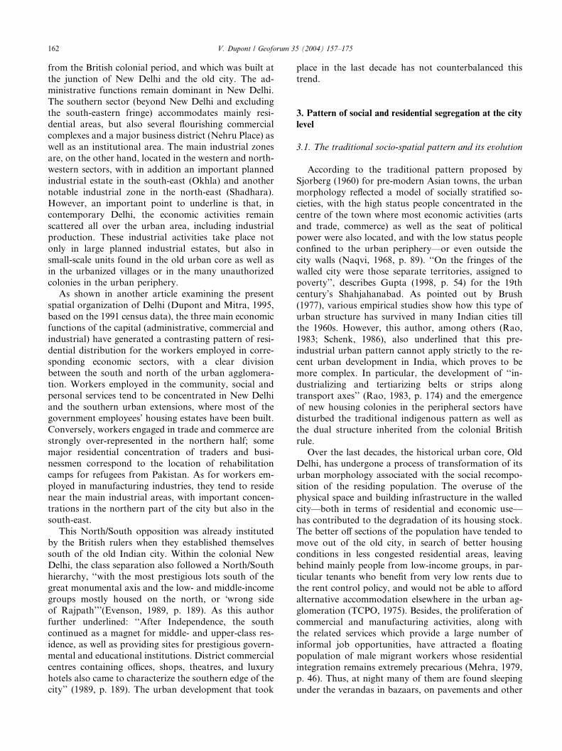
The analysis of the residential distribution of the
scheduled caste population at the level of the censusdivision, on the basis of the 1991 census data, 15 pro-
vides further evidences (Map 2). The percentage of
scheduled castes in the total population of Delhi Union
Territory in 1991 was 19%, with considerable variations
within the urban area: from less than 5% in certain di-
visions up to a maximum of 56%. Furthermore, half the
scheduled caste population is concentrated in 40 census
divisions whose corresponding share in the total urbanpopulation is only 27%. The pockets showing high
percentages of scheduled castes are not however con-
centrated in the same geographical sector of the urban
agglomeration; they are rather scattered, some being
located in the central area, including certain divisions of
Old Delhi as well as New Delhi, and others in the pe-
ripheral zones. Such a spatial pattern of local concen-
tration cum global dispersion also applies to the locationof squatter settlements: as seen above, the �jhuggi-jhonpriclusters’ (slums pockets) were found in all sections of the
capital, occupying not only vacant land in the urban
fringe, but also all the interstices of the urban fabric
(Map 1).
Our 1995 survey on population mobility and resi-
dential practices in the Delhi Metropolitan Area (see
Section 4) shows that the percentage of scheduled castepopulation is generally significantly higher in the
squatter settlements than in the surrounding residential
neighbourhoods, and than in the population of Delhi as
a whole (19% as per the 1991 census). For example, this
percentage reached: 16
• 39% in Rajiv Gandhi Camp (a big slum pocket ad-
joining the Nehru Stadium, in New Delhi) as against7% in the nearby government blocks of flats;
• 36% in the slums of the Badli-Rohini zone (in the
west-northern periphery) as against 10% in the
planned housing sectors;
• 64% in Tigri jhuggi-jhonpri Camp (in the southern pe-
riphery) as against 25% in the adjoining unauthorised
colony and the DDA flats for weakly economic sec-
tions (the corresponding census division on Map 2for 1991 does exhibit one of the highest percentages
of scheduled castes);
15 Following the abolition of untouchability by the Constitution of
India (1950, Article 17) and the special provision for the advancement
of the scheduled castes through the reservation of a certain quota of
posts in the services under the State (Articles 15 & 16), one can
presume that the identification of the scheduled castes by the Census is
reasonably reliable.16 The study of the Mayur Vihar–Trilokpuri zone is detailed in the
next section. As for the last two zones covered in our 1995 survey, their
samples did not include squatter settlements.
• 39% in the slum pockets of Noida (a new industrial
township in the eastern suburb) as against 2% in
the planned sectors.
These evidences substantiate the link between the
spatial residential pattern of the scheduled castes and the
scattered distribution of the squatter settlements inDelhi.
Thus, two factors that contribute to the present res-
idential clustering of the scheduled caste population and
their spatial distribution within the urban agglomeration
were identified: the survival of harijan bastis for ex-un-
touchable populations who had been socially ostracisedand segregated for generations in separated urban
quarters or rural hamlets now absorbed in the urban
spread; and the contemporary concentration of poor
scheduled caste migrants in squatter settlements, 17 the
only dwelling option they can afford in the city.
3.3. Residential proximity and relationships between
social classes
Since these attributes (ex-untouchability, living in a
squatter settlement) help to identify the lower socio-
economic strata, their residential spatial pattern could
be related to another observation made by Nagpaul(1988, p. 189): ‘‘a striking feature of Delhi is that even
planned localities, posh or middle-class, contain a large
number of temporary structures established haphaz-
ardly where domestic and lower-class workers live’’. It
can be also interpreted as a manifestation of what
Schenk (1986, p. 183) has identified as the ‘‘two seem-
ingly contradictory societal forces upon the socio-spatial
structure of urban residence: (a) the aim to reside insocially homogeneous areas, and (b) the aim and the
need to maintain relations of dependency’’. The first
principle would explain the existence of residential
clusters based on a common socio-economic back-
ground or geographical origin in case of migrants––
�being among own people’ (as it will be illustrated in the
next section). Whereas the principle of patronage would
account (to some extent) for the proximity betweensome lower-class clusters and certain upper- and middle-
class residential areas, the inhabitants of the former
providing services to those of the latter.
In Delhi the residential proximity between social
classes is frequently associated with the development of
economic relationships between the various segments of
the urban population: in fact it is often a residential and
economic strategy developed by the more underprivi-
17 Several studies on squatter settlements in Delhi have shown that
most of the households in this type of settlement are migrants. See for
example Suri (1994, 130). This is also confirmed by our 1995 survey in
Delhi: in the squatter settlements of the sample, the percentage of
household heads who were born outside the Delhi Territory varied
from 85% to 100%.

35 to 60 %
25 to 35
20 to 25
15 to 20
10 to 15
0 to 10
Limits of Delhi National Capital Territory
Limits of urban zones as per the 1991 census
Yamuna river
Percentage of Scheduled Castes population among total population in 1991, by censusdivision
Average for the National Capital Territory of Delhi : 19.1%
Old Delhi
Source of data : Census of India 1991, Series 31 Delhi, Primary Census Abstract.Digitized map :
Laboratoire de Cartographie Appliquée - IRD (Bondy).R.M.S.I. (New Delhi),
*
V. Dupont & LCA - IRD (Bondy) - M. Danard
0 5 10 km
N
Map 2. Residential location of scheduled castes population in Delhi National Capital Territory (1991).
V. Dupont / Geoforum 35 (2004) 157–175 165
leged groups. Economic relationships do not exclude
tensions between classes, however, or cases of violence
engendered by residential proximity and glaring in-
equalities in living conditions between the better-off and
the underprivileged. Some incidents arise from the lack
of proper sanitary infrastructure in the squatter settle-ments, leading therefore to the use of parks in nearby
residential quarters to defecate (VHAI, 1993, p. 56). 18
18 In a dramatic instance, the rage of the residents in a block of flats
impelled them to fire at some young from the squatter settlement
defecating in their park (Times of India, October 1994).
Other incidents, reported by residents interviewed in
affluent colonies of South Delhi (Defence Colony, DLF
Qutab Enclave), pertain to accusations against the ad-
joining slum or urban village dwellers in the event of
burglaries. In wealthy localities, like Defence Colony,
where an open drain crosses the residential quarters andconnects those to the nearby squatter settlements, the
residents’ suspicion about the slum dwellers caused the
erection of fences all along the drain and on its bridges,
to prevent any intrusion into the colony by this way.
This illustrates the growing security phobia of Delhi’s
well-to-do citizens and their fear of the poor, and thus
166 V. Dupont / Geoforum 35 (2004) 157–175
their attempts to enclose themselves in protected hous-
ing quarters.
4. Case study of the Mayur Vihar–Trilokpuri zone in East
Delhi: social heterogeneity and micro-level segregation
The various types of settlement and their spatial ar-
rangement are the outcome of the interactions between
institutional and non-institutional actors: the planning
efforts and urban policies of the Delhi Administration
(and their limitations) on the one hand, and the re-sponses and residential strategies of the households on
the other. The case study of the Mayur Vihar–Trilok-
puri zone in East Delhi provides a good illustration of
the variety of situations found in Delhi in this respect.
The socio-economic diversity of the residents in this
zone will allow us to show how residential strategies and
mobility (resulting from choices and/or more or less
stringent constraints) of different social groups may leadto a pattern of social and residential segregation at a
local or even micro-local scale. We shall also attempt to
highlight the different factors explaining residential
clustering and socio-spatial division.
Methodology and Data Sources
This study is part of a larger research programme on
spatial mobility and residential practices of Delhi’s pop-
ulation, and its effect on the dynamics of the metropolis
(Dupont and Prakash, 1999). The methodology com-
bined quantitative and qualitative approaches and dif-
ferent sources of information to integrate the following:
• an analysis of secondary data and information avail-
able on Delhi and its metropolitan area;
• a statistical survey of population samples from seven
zones in the metropolitan area covering about 1700
individuals (among which 696 in the Nehru Stadium
zone, 847 in Badli-Rohini, 867 in Tigri, and 2013 in
Noida––to quote only the zones referred to in the
previous section);• in-depth interviews of sub-samples of individuals in
some of the surveyed zones;
• the formation of a data base of background informa-
tion on each zone studied, by the compilation of data
and existing documents, direct observation and inter-
views with relevant informants (Sidhu, 1995).
Mayur Vihar–Trilokpuri was one of the selectedzones, located in the eastern periphery of Delhi (Map 1).
The statistical survey conducted in March 1995 in this
zone covered a representative sample of 342 households,
corresponding to 1798 individuals. In-depth interviews
focussing on the various factors influencing the choice of
residence were conducted in 1996 and 1997 with about 40
residents (Sidhu, 1996, 1997). These were completed with
a few additional interviews with secretaries of residents’
associations and real estate agents in April 1999. Field
work and data collection were conducted under the di-
rection of the author, and most of the in-depth interviewsused for this contribution were realised by Mriga Sidhu.
4.1. A mosaic of settlements
Mayur Vihar and Trilokpuri form a widespread zone
located in the eastern periphery of Delhi. This zone is
characterised by average to very high residential densi-
ties, and rapid population growth during the last 20
years (during the 1981–1991 decade: 5–13.8% per year as
against 3.9% for the entire urban agglomeration). Var-
ious modes of urbanization are found that exemplify
urban expansion in the peripheries of the capital. Theoriginal villages are nowadays hemmed in by the new
residential neighbourhoods that gradually developed
from 1970–1975:
• unauthorized (and a posteriori regularized) colonies;
• a large resettlement colony (Trilokpuri) set up during
the emergency state (1975–1977) to relocate the slum
dwellers evicted from squatter settlements in the innercity;
• many blocks of flats of three to four storeys built by
the Delhi Development Authority in the late 1970s
and early 1980s for the middle- and low-income
groups, clustered into five large �pockets’ (the �DDA
flats’);
• many other blocks of flats built since 1985 by co-
operative group housing societies;• and, in the interstices of the urban fabric, slum pock-
ets, or more precisely squatter settlement clusters with
very precarious housing, sometimes just adjoining
upper-class apartment blocks.
These different types of settlement correspond to very
distinct segments of the housing stock in terms of
housing standards and equipment (Table 1). Hence theDDA and co-operative group housing societies’ apart-
ments blocks are the only ones to provide systematically
a permanent building structure and modern standards
of comfort with running water, toilet, bathroom and a
separate room for the kitchen. Not surprisingly, the
worst housing conditions are found in squatter settle-
ments: in most of the cases none of these facilities are
available in the dwelling, while adequate civic amenitiesand urban services are also lacking. The over-crowding
of dwellings is moreover especially acute in squatters
settlements (78% of the dwellings have only one living
room) but also in unauthorized colonies (66% of the
dwellings have only one living room) when the average
household size is 5.2 persons in the first case and 4.5
in the second.

Table 1
The Mayur Vihar–Trilokpuri zone in East Delhi: characteristics of the dwelling by type of settlement
Characteristics of the
dwelling
Type of settlement
Resettlement
Colony
DDA flats Cooperative
group housing
societies
Urban villages Unauthorized
and regular-
ized colonies
Squatter
settlements
All types
No. of years since built Percentage distribution for each type of settlement
<5 1.5 – 28.2 2.2 33.9 – 10.2
5–9 7.5 – 71.8 11.1 32.3 4.8 18.7
10–19 91.0 100 – 11.1 27.4 85.7 59.4
P 20 – – – 75.5 6.5 9.5 11.7
% of precarious or
semi-precarious
structure
9.0 0 0 11.6 18.3 91.3 13.8
% of dwellings includ-
ing economic use
4.4 14.3 5.1 45.6 32.3 15.8 16.7
No. of living rooms Percentage distribution for each type of settlement
1 35.3 – – 37.2 66.1 78.3 35.7
2 50.4 – 17.9 30.3 19.4 13.0 29.8
3 7.5 85.7 41.1 11.6 9.7 8.7 21.9
P 4 6.8 14.3 41.0 20.9 4.8 – 12.6
% of dwellings without
separate kitchen
78.9 – – 46.5 56.5 96.0 53.2
% of dwellings without
bathroom
80.4 – – 32.6 35.5 96.0 48.2
% of dwellings without
toilet
85.0 – – 32.6 20.2 96.0 47.1
% of dwellings without
drinking water
12.0 – – – 13.3 82.6 12.6
Status of occupancy Percentage distribution for each type of settlement
Owned (legally) 92.5 80.9 51.2 62.2 58.3 – 70.4
Rented 6.8 16.7 48.8 26.7 36.7 – 20.5
Other 0.7 2.4 – 6.7 5.0 100
(squattted)
9.1
Total no. of dwellings 133 42 41 43 60� 23 342
Row percentage 38.9 12.3 12.0 12.6 17.5 6.7 100.0
Source of data: ORSTOM-IEG household survey––1995.� Out of 60 dwellings, 47 are in unauthorized colonies (¼ 76%), and 13 in regularized colonies (¼ 21%).
V. Dupont / Geoforum 35 (2004) 157–175 167
4.2. A ‘segregated mixture’ of different socio-economic
and income groups
The variety in types of settlement and housing reflects
directly the composition of the population that shows a
mixture or rather a juxtaposition of different socio-eco-
nomic groups. As expected, the various types of settle-ment house distinct income groups, with their specific
occupational and employment structures (Table 2). The
residents of the co-operative group housing societies’
apartments clearly emerge as a distinctive group with a
higher economic status: they have the highest percentage
of female working participation rate (21% as against 8%
for the zone average), and among their working popula-
tion they record the highest percentage of employedpersons engaged in professional and technical occupa-
tions (41% as against 15% on the average) as well as ad-
ministrative, executive and managerial functions (29% as
against 7% on the average), and the highest percentage of
employers––as par with the DDA flats’ residents (17% as
against 7% on the average). Finally, their income distri-
bution places them in the highest income group with 46%
of the employed persons earning 7500 Rs. or more permonth (as against 11% on the average). According to
these indicators, the DDA flats’ residents rank second on
the economic scale (with 30% of the employed persons
earning 7500 Rs. or more per month). At the lower rank
of the income scale, one finds––not surprisingly––the
slum dwellers: 84% of the working members earn less
than 2000 Rs. per month (as against 45% for the zone
average); in addition only 57% of them have re-gular work, while the corresponding proportion reaches

Table 2
The Mayur Vihar–Trilokpuri zone in East Delhi: economic characteristics of the residents by type of settlement
Workers’ characteristics Type of settlement
Resettlement
Colony
DDA flats Cooperative
group housing
societies
Urban villages Unauthorized
and regular-
ized colonies
Squatter set-
tlements
All types
% of workers in total
population
27.3 32.9 38.3 32.2 33.7 31.3 31.1
Pearson Chi-square test––significance¼ 0.0%
% of workers in female
population
3.7 13.4 20.9 7.7 8.4 8.7 8.3
Pearson Chi-square test––significance¼ 0.2%
Total population (no.) 736 240 183 258 282 99 1798
Working population
Main occupation Percentage distribution for each type of settlement
Professional, technical 4.0 36.7 41.4 4.8 13.7 – 14.8
Administrative,
executive, managerial
0.5 17.7 28.6 1.2 4.2 – 7.2
Clerical workers 7.5 20.3 8.6 7.2 7.4 – 8.9
Sales workers 13.9 6.3 11.4 13.3 16.8 22.6 13.4
Service workers 13.9 3.8 4.3 16.9 13.7 12.9 11.6
Farmers and related
workers
0.5 1.3 – 21.7 – – 3.6
Production workers 40.3 13.9 2.9 22.9 35.8 38.7 28.4
Construction workers 12.4 – 1.4 9.6 3.2 16.1 7.5
Transport workers 7.0 – 1.4 2.4 5.3 9.7 4.5
Total 100.0 100.0 100.0 100.0 100.0 100.0 100.0
Pearson Chi-square test––significance¼ 0.0%
Employment status Percentage distribution for each type of settlement
Employer 3.0 16.7 17.4 3.6 4.2 6.5 7.1
Own account worker 17.1 12.5 8.7 20.5 16.0 38.7 17.0
Employee––private 25.6 43.0 23.2 22.9 23.4 6.5 25.7
Employee––public 51.2 25.0 46.4 39.8 56.4 45.2 46.0
Unpaid helper 3.0 2.8 4.3 13.3 – 3.2 4.2
Total 100.0 100.0 100.0 100.0 100.0 100.0 100.0
Pearson Chi-square test––significance¼ 0.0%
Nature of work Percentage distribution for each type of settlement
Permanent, regular 72.4 95.9 97.1 90.4 85.1 56.7 82.6
Temporary, seasonal 18.1 1.4 2.9 6.0 9.6 33.3 11.5
Casual 9.5 2.7 – 3.6 5.3 10.0 5.9
Total 100.0 100.0 100.0 100.0 100.0 100.0 100.0
Pearson Chi-square test––significance¼ 0.0%
Monthly income (Rs.) Percentage distribution for each type of settlement
<1000 15.2 3.0 4.5 24.1 6.8 35.5 13.9
1000–1999 42.1 1.5 6.0 39.8 37.5 48.4 31.7
2000–2999 20.8 9.0 1.5 19.3 28.4 6.5 17.1
3000–4999 17.3 25.4 13.4 9.6 14.6 6.5 15.6
5000–7499 3.6 31.3 28.3 4.8 6.7 3.2 10.9
P 7500 1.0 29.8 46.3 2.4 5.7 – 11.2
Total 100.0 100.0 100.0 100.0 100.0 100.0 100.0
Pearson Chi-square test––significance¼ 0.0%
Total workers (no.) 201 79 70 83 95 31 559
Source of data: ORSTOM-IEG household survey––1995.
19 The Chi-square test of independence between the variables �typeof settlement’ and �religion’ in the sample population shows an
association significant at the 0.00% level, and that between the
variables �type of settlement’ and �caste category’ an association also
significant at the 0.00% level.
168 V. Dupont / Geoforum 35 (2004) 157–175
96–97% among the employed persons living in DDA and
co-operative group housing societies’ flats. To sumup, the
differential analysis of the economic characteristics ofthe inhabitants by type of settlement demonstrates the
significance of occupational category and income level in
the phenomenon of residential clustering and segregation.
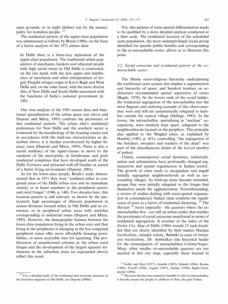
The most striking features in terms of socio-cultural
cum residential segregation regard the differential com-
position of the population by caste and religion. 19
Thus, while Muslims represent 11% of the total popu-
V. Dupont / Geoforum 35 (2004) 157–175 169
lation of the zone, their proportion reaches 43% in the
squatter settlements, and, on the other hand, becomes
marginal in DDA flats, unauthorized colonies, and even
virtually nil in the co-operative group housing societies(Fig. 1). Appraised in terms of population concentra-
tion, in the Mayur Vihar–Trilokpuri zone 85% of the
Muslim population live in squatter settlements and re-
settlement colonies, while these two types of settlement
house only 46% of the total population.
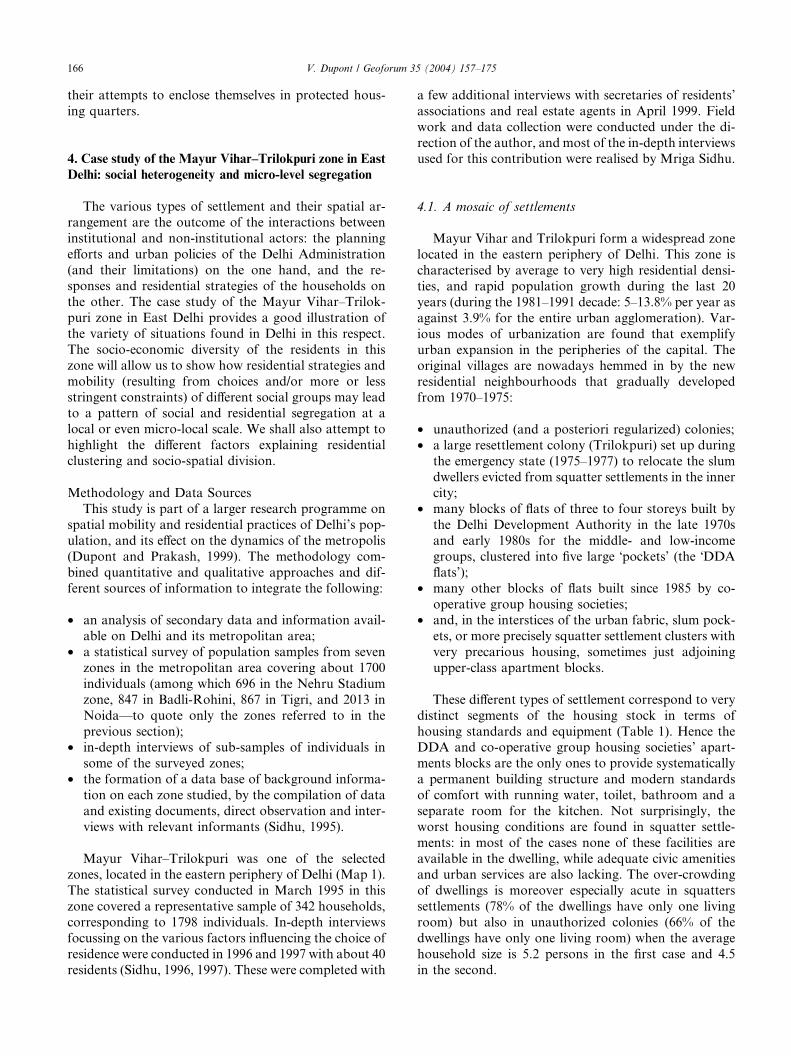
The scheduled castes and other backward classes 20
have also a marginal presence in DDA flats and co-
operative group housing societies’ apartments (4% oftheir residents), while they account for half of the in-
habitants of the entire Mayur Vihar–Trilokpuri zone
(Fig. 2). The preferential residential choice of the upper
castes can be highlighted in terms of population con-
centration: in the zone under study, 44% of the upper
caste population reside in DDA flats and co-operative
group housing societies’ apartments, while these two
types of housing account for only 23% of the populationof the zone. The high percentages of scheduled castes
and other backward classes in urban villages (respec-
tively 41% and 42% of their population) correspond to
the caste composition of the original rural settlers of this
area, with two major groups, the Gujjars (classified
among the backward classes) and the Jatav (belonging
to the scheduled castes). The scheduled castes are also
statistically over-represented in the Trilokpuri resettle-ment colony (37% as against 27% in the population of
the entire zone). Since this colony was established for
squatters evicted from their previous settlement sites,
this is another illustration of the cumulative causation
between low social and economic status, and lack of
access to proper housing (as already underlined in the
previous section).
The sharp differences in the educational level of thevarious groups of residents complete this contrasted
socio-cultural portrait. 21 According to this criterion,
the slum dwellers are the most underprivileged group,
with 42% of illiterate (among the population aged 5 and
above) and a negligible proportion who had reached the
level of college. By contrast, the best educated groups
are found in DDA flats and co-operative group housing
societies’ apartments: respectively 53% and 62% of theirresidents (aged 5 and above) have studied up to the
college or beyond, while the illiterates account for only
10%.
20 Besides a list of the scheduled castes (the ex-untouchable castes),
the state governments have also identified a list of other backward
classes (OBC), corresponding to other castes and communities of low
social and economic status.21 The Chi-square test of independence between the variables �type
of settlement’ and �educational level’ in the sample population shows
an association significant at the 0.00% level.
The analysis of the residential location of the sched-
uled caste population and the illiterates at the level of
the whole urban agglomeration has already highlighted
a pattern of high concentration of these underprivilegedgroups in certain census divisions and their marginal
presence in others. A similar pattern of residential
clustering along religion and caste lines, or educational
level is again evidenced within the Mayur Vihar–Tril-
okpuri zone. A more detailed analysis of each urban
village would reveal a phenomenon of micro-level seg-
regation, with distinct mohallas (neighbourhoods or
quarters) inside the village for each major caste group.Furthermore, among the scheduled caste population,
there is also a social hierarchy directly reflected in the
space: hence, the Balmiki, traditionally a caste of
sweepers with a very low status, always occupy a sepa-
rate mohalla in the village.
The persistence of social and residential segregation,
not only in the original villages, but also between the
different types of settlements associated with the recentprocess of urbanization in the peripheral zones of the
capital, raises several questions. The observed socio-
spatial pattern can be interpreted as the result of a se-
lective access to the various segments of the housing
stock. Yet, does this selective access reflect only the
differentials in purchasing power and renting capacity of
the various groups of residents? Can we also interpret
this as the manifestation of a process of exclusion anddiscrimination, or ostracism against the most vulnerable
social and economic groups? To what extent is the ten-
dency to residential clustering the result of the individ-
uals’ deliberate choices, or that of constraints imposed
on them?
One could argue in particular that the concentration
of low castes and minority communities in the inferior
(illegal or/and under-equipped) segments of the housingstock is the consequence of a multiple-layers of depri-
vation: low social status, low level of education and
access to jobs at the lower rung of the hierarchy, and
thus limited resources that bar these groups from en-
tering into the upper segments of the housing stock. 22
This is certainly true, but not sufficient to explain other
processes of segregation. For example the relegation of
some ex-untouchable castes in distinct quarters of theurbanised villages is a clear manifestation of the per-
sistence of social ostracism. The geographical origin of
the residents in the different types of settlements will
further show that income differentials cannot account
for certain phenomena of residential clustering. Lastly, a
closer look at the procedure of access to apartments in
22 To investigate further this point, one could envisage finer cross-
tabulations of social attributes (like caste category and religion) by
type of settlement, controlled by the income level: unfortunately the
size of our sample in the zone under study limits the possibility of
differential statistical analysis.
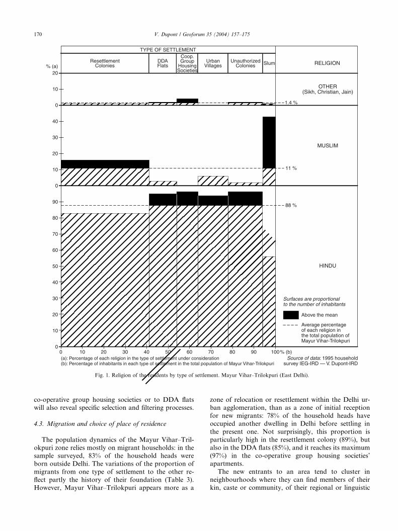
(a): Percentage of each religion in the type of settlement under consideration(b): Percentage of inhabitants in each type of settlement in the total population of Mayur Vihar-Trilokpuri
% (a)
10
20
30
40
0
10
20
50
60
70
80
90
0
0
10
20
30
40
0 10 20 30 40 50 60 70 80 90 100% (b)
88 %
11 %
1.4 %
ResettlementColonies
DDAFlats
Coop.Group
HousingSocieties
UrbanVillages
UnauthorizedColonies Slum RELIGION
OTHER(Sikh, Christian, Jain)
MUSLIM
HINDU
TYPE OF SETTLEMENT
Average percentageof each religion in the total population of Mayur Vihar-Trilokpuri
Above the mean
Surfaces are proportional to the number of inhabitants
Source of data: 1995 householdsurvey IEG-IRD — V. Dupont-IRD
Fig. 1. Religion of the residents by type of settlement. Mayur Vihar–Trilokpuri (East Delhi).
170 V. Dupont / Geoforum 35 (2004) 157–175
co-operative group housing societies or to DDA flats
will also reveal specific selection and filtering processes.
4.3. Migration and choice of place of residence
The population dynamics of the Mayur Vihar–Tril-
okpuri zone relies mostly on migrant households: in the
sample surveyed, 83% of the household heads were
born outside Delhi. The variations of the proportion of
migrants from one type of settlement to the other re-
flect partly the history of their foundation (Table 3).
However, Mayur Vihar–Trilokpuri appears more as a
zone of relocation or resettlement within the Delhi ur-
ban agglomeration, than as a zone of initial reception
for new migrants: 78% of the household heads have
occupied another dwelling in Delhi before settling in
the present one. Not surprisingly, this proportion is
particularly high in the resettlement colony (89%), but
also in the DDA flats (85%), and it reaches its maximum
(97%) in the co-operative group housing societies’apartments.
The new entrants to an area tend to cluster in
neighbourhoods where they can find members of their
kin, caste or community, of their regional or linguistic

TYPE OF SETTLEMENT
(a): Percentage of each caste category in the type of settlement under consideration(b): Percentage of inhabitants in each type of settlement in the total population of Mayur Vihar-Trilokpuri
% (a)
0
10
20
30
40
50
60
70
80
90
100
0
10
20
30
40
50
0
10
20
30
40
0 10 20 30 40 50 60 70 80 90 100% (b)
27 %
22 %
51 %
ResettlementColonies
DDAFlats
Coop.Group
HousingSocieties
UrbanVillages
UnauthorizedColonies Slum CASTE
CATEGORY
UPPERCASTES
OTHERBACKWARDCLASSES
SCHEDULEDCASTES
ANDTRIBES
Average percentageof each caste categoryin the total population of Mayur Vihar-Trilokpuri
Above the mean
Surfaces are proportional to the number of inhabitants
Source of data: 1995 householdsurvey IEG-IRD — V. Dupont-IRD
Fig. 2. Caste group of the residents by type of settlement. Mayur Vihar–Trilokpuri (East Delhi).
V. Dupont / Geoforum 35 (2004) 157–175 171
group. As confirmed by the in-depth interviews, familial
and social networks play a significant role in the process
of in-migration and urban insertion, including the
choice of the place of residence––upon arrival in the city
especially, but also for a change of dwelling within the
urban agglomeration.
The geographical origin of the migrants proves to be
a differential factor of the population composition

Table 3
The Mayur Vihar–Trilokpuri zone in East Delhi: geographical origin of the residents by type of settlement
Geographical origin Type of settlement
Resettlement
colony
DDA flats Cooperative
group housing
societies
Urban villages Unauthorized
and regularized
colonies
Squatter
settlements
All types
% of residents born
outside Delhi
38.9 45.4 50.9 34.5 53.2 43.4 42.8
(total no. of residents) (736) (240) (183) (258) (282) (99) (1798)
Pearson Chi-square test––significance¼ 0.0%
Birth placea Percentage distribution of migrants for each type of settlement
North India 96.5 69.7 44.1 94.4 88.2 90.7 84.2
West India 2.4 2.8 9.7 3.4 5.9 2.3 4.1
South India 0.4 10.1 18.3 2.2 1.3 – 4.3
East India 0.7 4.6 12.9 – 2.6 7.0 3.4
Outside India – 12.8 15.0 – 2.0 – 4.0
Total migrants 100.0 100.0 100.0 100.0 100.0 100.0 100.0
(no. of migrants) (287) (109) (93) (89) (152) (43) (773)
Pearson Chi-square test––significance¼ 0.0%
Source of data: ORSTOM-IEG household survey––1995.a Classification of birth place: North India¼Uttar Pradesh (mainly), Bihar, Haryana, Himachal Pradesh, Punjab, Chandigarh, Rajasthan; West
India¼Madya Pradesh, Maharashtra; South India¼Andhra Pradesh, Karnataka, Kerala, Tamil Nadu; East India¼Orissa, West Bengal; Outside
India¼Pakistan (mostly), Bangladesh, Nepal. This classification includes only States and Union Territories from where some migrants had come.
172 V. Dupont / Geoforum 35 (2004) 157–175
across different types of settlement (Table 3). While, at
the level of the entire zone, 84% of the migrants hail
from North India, 23 the population living in the co-
operative group housing societies’ apartments appear to
be much more diversified in terms of regional origin: in
particular, it includes significant communities of resi-
dents from South India (18% of the migrants) and East
India (15%), as well as from foreign countries––mainlyrefugees from Pakistan––(13%). To a lesser extent, mi-
grants from South India and refugees from Pakistan
form also notable groups in the DDA flats. These
findings, corroborated by interviews, suggest that social
networks based on geographical origin constitute a po-
tential factor of residential clustering.
24 Almost half of the households surveyed in the co-operative group
housing societies’ flats of Mayur Vihar were tenants.25 Auclair (1998, Chapter 6) highlights similar processes in her study
4.4. Clustering and filtering processes in the upper
segments of the housing stock
A good illustration of clustering process is found in
the apartment blocks built and managed by co-operative
group housing societies. The constitution of the co-op-erative societies is from the beginning based on an as-
sociation of prospective flats’ buyers who belong to
similar social or professional networks, and usually
share some common attributes. Very frequently the as-
sociation is formed on the basis of a common profes-
sional affiliation: lawyers of the Supreme Court,
23 This is also one characteristic of the migration flows to the Delhi
National Capital Territory as a whole: according to the census, 79% of
the migrants residing in Delhi in 1991 hailed from the States of Uttar
Pradesh, Bihar, Haryana, Punjab and Rajasthan. (For an analysis
of the main migration flows to Delhi, see Dupont, 2000b).
employees from the same press group, or the same in-
stitute, officers from the police, high rank government
officers, or teachers from the same university, for in-
stance. The founding group is then in a position to exert
control on the selection of new buyers, while the owners
renting out their flats apply a screening process on the
prospective tenants. 24 This system of co-optation and
selection ensure a social and professional homogeneityof the residents of the same complex of apartment
blocks. The above findings suggest that the selection
(and therefore exclusion) process includes also criteria
of religion and caste group. 25 Furthermore, a filter-
ing procedure applies to visitors as fences or walls
enclose residential complexes, with gates and watch-
men controlling all people entering. This concern for
security and protection from �outsiders’ (also observedin other zones of Delhi, as illustrated in the previous
section) recalls the gated communities of North Amer-
ica, the townhouses of South African cities (Benit,
2000), or similarly closed and protected residential
complexes in Latin American cities (Dureau, 2000; Pa-
quette, 2000).
of the private housing sector in Chennai. She shows how the Brahmans
control the new mutli-family residential complexes in three neighbour-
hoods under redevelopment. As initial landowners and/or future flat
owners in the buildings, the Brahmans prod the builders in filtering the
customers in order to ensure a socially and culturally homogeneous,
familiar living environment. As for the tenants, the implicit condition
to access these higher-caste residential buildings is to be vegetarian,
and the caste appears as an important criterion of selection.
V. Dupont / Geoforum 35 (2004) 157–175 173
One could have expected more social and profes-
sional mixing in the DDA flats, since the procedure of
flat allocation is based on a lottery system. In some
pockets of Mayur Vihar the three and four storiedapartments blocks were even built with a concern for
economic mixing, that is to provide accommodation for
middle-income groups (flats located on the ground floor
and first floor) as well as low-income groups (flats lo-
cated on the upper floors). As shown by the above dif-
ferential analysis however, the socio-economic profile of
the residents of the DDA flats is twisted in favour of
higher income groups and higher social status groups. InMayur Vihar like in other public housing programmes,
the quota of flats for lower-income groups tends even-
tually to benefit better-off sections (Dupont, 2003). The
socio-economic composition of the initial allotees is later
altered by the resale of flats under power of attorney, 26
as well as by the renting out of flats. 27
Renting of apartments and houses, in DDA buildings
as well as in other types of housing estates, always in-volves a screening process of the prospective tenants by
the owner. This selection procedure is based not only on
economic considerations, but also on subjective criteria,
and gives way to possible discrimination; the owners are
often inclined to give preference to tenants who share
with them similar social and cultural attributes.
The findings from the Mayur Vihar–Trilokpuri case
study suggest that the composition of the populationresiding in different types of settlement cannot be ex-
plained merely by income differentials. Social networks
based on caste, religion, professional occupation and
geographical origin also play their role in favouring
residential clustering in a more or less exclusive man-
ner––and hence in generating segregation.
5. Concluding remarks
Notwithstanding an urban-based socio-economic and
functional division of the capital between the northern
and southern halves, the large sectors of Delhi prove tobe relatively heterogeneous in terms of types of settle-
ments and socio-economic groups of residents. It would
be, however, misleading to conclude that residential
segregation in Delhi is a mild phenomenon: homoge-
neity and heterogeneity are notions that depend on the
scale of observation. In fact, residential segregation in
26 The system of 99 year lease-hold that applies to the flats sold by
the DDA prohibits resale for the first 10 years; then it requires the
payment of 50% the appreciation in value upon resale. Hence unofficial
reselling of flats takes place under power of attorney, a system that
allows a land/house owner to legally pass on the use rights of his
property to others without actually transferring its ownership.27 In the Mayur Vihar sample, 19% of the DDA flats were occupied
by tenants.
Delhi takes place at a finer scale. Hence a wide socio-
economic variety of settlements and residents at the level
of a zone (the Mayur Vihar–Trilokpuri one, for in-
stance) may be associated with phenomena of markedsegregation at the level of much more limited spaces (a
residential colony, a group of buildings, some blocks of
flats, a slum pocket, an urban village quarter). The so-
cio-spatial organization of Delhi could be characterized
by a combination of residential and social segregation at
a micro, neighbourhood-level and relative dispersion at
the macro, urban level––a dispersion that is also ob-
served for economic activities. Physical proximityamong different social groups does not imply, however,
social proximity and harmonious relationships.
From the British town planners to the post-Inde-
pendence Delhi Development Authority, institutional
actors have had a major role in shaping the urban
landscape of the Indian capital city and the spatial ar-
rangement of its different types of settlement, and
therefore in influencing the spatial distribution of vari-ous socio-economic groups. Yet, the process of socio-
spatial differentiation of the urban area reflects the
limitations of town planning and housing policy as
much as their actual achievements, and private initia-
tives and responses as much as state intervention.
Households’ residential aspirations prove to be a sig-
nificant factor contributing to residential clustering and
segregation, although the choices of large sections of theurban population are limited by more or less stringent
financial constraints. Hence, the resulting lines of seg-
regation are the combined effect of income differentials,
socio-economic status and professional group, caste and
religious affiliation, geographical origin. The enclave or
ghetto phenomenon is found both among the privileged
and underprivileged population groups, as shown by the
examples of rich families’ co-operative group housingsocieties and poor migrants’ hutment clusters.
Several forms of residential segregation observed in
contemporary Delhi are the outcome of differential
residential mobility combined with processes of social
selection, as shown in the case of Chicago by pioneer
urban ecological studies in the 1920s (Burgess, 1925).
The emerging pattern of socio-spatial differentiation
may be the consequence of active or passive filteringmechanisms, or a combination of both. For instance, the
social re-composition of the historical core of the city,
Old Delhi, results from the better-off sections of the
population moving out of the central zone of the city in
search of new buildings, more modern and comfortable
housing conditions, while low-income groups stay back
on the same site for lack of alternative viable options
and remain in deteriorating housing stock. In the urbanperipheries, the establishment of many co-operative
group housing societies’ blocks of flats illustrates a de-
liberate filtering process of the residents, while the ori-
ginal villages are de facto transformed into traditional
174 V. Dupont / Geoforum 35 (2004) 157–175
settlement enclaves by the expansion of the urban ag-
glomeration. Thus, the social mosaic that composes the
metropolitan fabric appears as an ever-evolving socio-
spatial arrangement with multiple causal factors.
Acknowledgements
This study is part of a larger research programme onspatial mobility and residential practices of Delhi’s
population. The programme was financed by the Institut
de Recherche pour le D�eveloppement (ex-ORSTOM) with
additional funding from the CNRS within the frame-
work of Action Concert�ee en Sciences Sociales (Con-
certed Action in the Social Sciences) ORSTOM-CNRS
and of PIR-Villes. In India, our programme was con-
ducted with the collaboration and support of the Centrede Sciences Humaines based in Delhi (French Ministry
of External Affairs) and the Institute of Economic
Growth (Delhi).
References
Ali, S., 1990. Slums within Slums. A Study of Resettlement Colonies in
Delhi. Har-Anand & Vikas, New Delhi.
Auclair, C., 1998. Ville �a vendre. Voie lib�erale et privatisation du
secteur de l’habitat �a Chennai (Inde). French Institute of Pondi-
cherry, Pondicherry.
Banerjee, B., 1994. Policies, procedures and techniques for regularizing
irregular settlements in Indian cities. The case of Delhi. Urban
Research Working Papers 34. Universiteit Amsterdam, CASA,
Amsterdam.
Begde, P.V., 1978. Ancient and Medieval Town-Planning in India.
Sagar Publication, New Delhi.
Benit, C., 2000. Johannesburg: d�es�egr�egation raciale, s�egr�egationsociale? La banalisation des mobilit�es r�esidentielles dans la ville
d’apartheid. In: Dureau, et al. (Eds.), M�etropoles en mouvement.
Une comparaison internationale. IRD-Anthropos (Coll. Villes),
Paris, pp. 269–280.
Blake, S.P., 1986. Cityscape of an imperial capital. Shahjahanabad in
1739. In: Frykenberg, R.E. (Ed.), Delhi Through the Ages. Essays
in Urban History, Culture and Society. Oxford University Press,
Delhi, pp. 152–191.
Brun, J., 1994. Essai critique sur la notion de s�egr�egation et sur son
usage en g�eographie urbaine. In: Brun, J., Rhein, C. (Eds.), La
s�egr�egation dans la ville. L’Harmattan, Paris, pp. 21–58.
Brush, J., 1962. The morphology of Indian cities. In: Turner, R. (Ed.),
India’s Urban Future. University of California Press, Berkeley &
Los Angeles, pp. 57–70.
Brush, J., 1977. Growth and spatial structure of Indian cities. In:
Nobel, A.G., Dutt, A.K. (Eds.), Indian Urbanization and Plan-
ning, Vehicles of Modernization. Tata McGraw Hill, New Delhi,
pp. 64–93.
Brush, J., 1986. Recent changes in ecological patterns of metropolitan
Bombay and Delhi. In: Tewari, V.K., Weisten, J.A., Rao, V.L.S.P.
(Eds.), Indian Cities. Ecological Perspectives. Concept, New Delhi,
pp. 121–149.
Burgess, E.W., 1925. The growth of the city: an introduction to a
research project. In: Park, R.E., Burgess, E.W., Mac KenZie, D.
(Eds.), The City. University of Chicago Press, Chicago.
Datta, V.N., 1986. Panjabi refugees and the urban development of
Greater Delhi. In: Frykenberg, R.E. (Ed.), Delhi Through the
Ages. Essays in Urban History, Culture and Society. Oxford
University Press, Delhi, pp. 442–460.
DDA (Delhi Development Authority), 1990. Master Plan for Delhi.
Perspective 2001. Gazette of India, Extra ordinary, Part II, Section
3 Sub-section (ii) vide S.O.606 (E), 1st August 1990, Delhi.
Deli�ege, R., 1995. In: Les intouchables en Inde Des castes d’exclus.
Imago, Paris.
Diwakar, A., Quresh, M.H, 1993. Physical processes of urbanisation in
Delhi. Urban India 13 (2), 94–106 (NIUA, New Delhi).
Dupont, V., 2000a. Mobility patterns and economic strategies of
houseless people in Old Delhi. In: Dupont, V., Tarlo, E., Vidal, D.
(Eds.), Delhi Games. Urban Space and Human Destinies. Mano-
har-CSH, Delhi, pp. 113–141.
Dupont, V., 2000b. Spatial and demographic growth of Delhi and the
main migration flows. In: Dupont, V., Tarlo, E., Vidal, D. (Eds.),
Delhi. Urban Space and Human Destinies. Manohar-CSH, Delhi,
pp. 288–313.
Dupont, V., 2001. Les nouveaux quartiers chics de Delhi Langage
publicitaire et r�ealit�es p�eriurbaines. In: Rivi�ere d’Arc, H. (Ed.),
Nommer les nouveaux territoires urbains. Editions UNESCO/
Editions de la Maison des Sciences de l’Homme, Paris, pp. 390–
61.
Dupont, V., 2003. Pratiques r�esidentielles dans le parc de logements
publics d’une grande m�etropole indienne: L’exemple des DDA flats
de Delhi. autrepart, 2003/1, No. 25, IRD-L’Aube, pp. 21–36.
Dupont, V., Mitra, A., 1995. Population distribution, growth and
socio-economic spatial patterns in Delhi. Findings from the 1991
census data. Demography India 24 (1&2), pp. 101–132.
Dupont, V., Prakash J, 1999. Enquete: Mobilit�es Spatiales dans l’Aire
m�etropolitaine de Delhi. In: Biographies d’enquete, Coll. M�ethodeset savoirs. INED-PUF/Diffusion, Paris, pp. 279–315.
Dureau, F., 2000. Les nouvelles �echelles de la s�egr�egation �a Bogota. In:
Dureau, et al. (Eds.), M�etropoles en mouvement. Une comparaison
internationale. IRD-Anthropos (Coll. Villes), Paris, pp. 247–256.
Evenson, N., 1989. The Indian Metropolis, A View Toward the West.
Yale University Press, New Haven and London.
Frykenberg, R.E. (Ed.), 1986. Delhi Through the Ages. Essays in
Urban History, Culture and Society. Oxford University Press,
Delhi.
Gandhi, R., 1983. Social structure of urban India: continuities and
change. In: Gupta, G.R. (Ed.), Urban India (Main Currents in
Indian Sociology, vol. VI). Vikas, New Delhi, pp. 3–85.
Grafmeyer, Y., 1994. Regards sociologiques sur la s�egr�egation. In:
Brun, J., Rhein, C. (Eds.), La s�egr�egation dans la ville. L’Harmat-
tan, Paris, pp. 85–117.
Government of National Capital Territory of Delhi (Planning
Department), 1996. �Backgrounder’, State Level Seminar on
Approach to Ninth Five Year Plan (1997–2002), Delhi, Govern-
ment of National Capital Territory of Delhi.
Gupta, N., 1998. Delhi Between Two Empires. 1803–1931: Society,
Government and Urban Growth. Oxford University Press, Oxford
Indian Paperbacks, Delhi (first published 1981).
Hambly, R.G.G., 1982. Towns and cities: Mughal India. In: Ray-
chauduri, T., Habib, I. (Eds.), The Cambridge Economic History
of India, Vol. I (c. 1200–c. 1750). Cambridge University Press,
Orient Longman, Cambridge, Hyderabad, pp. 434–451.
Jain, A.K., 1990. The Making of a Metropolis. Planning and Growth
of Delhi. National Book Organisation, New Delhi.
Lewis, Ch., Lewis, K., 1997. Delhi’s Historic Villages. A Photographic
Evocation. Ravit Dayal Publisher, Delhi.
Kumaria, P., 1998. Delhi: factorial ecology and social space. In: Misra,
R.P., Misra, K. (Eds.), Millions Cities of India. Sustainable
Development Foundation, New Delhi, pp. 182–195.
Mehra, A.K., 1979. The Politics of Urban Redevelopment. A Study of
Old Delhi. Sage, New Delhi.

V. Dupont / Geoforum 35 (2004) 157–175 175
Metcalf, T.R., 1986. Architecture and empire. Sir Herbert Baker and
the building of New Delhi. In: Frykenberg, R.E. (Ed.), Delhi
Through the Ages. Essays in Urban History Culture and Society.
Oxford University Press, Delhi, pp. 391–400.
Misra, B., Singh, R.B., Malik, A., 1998. Delhi metropolis: housing and
quality of life. In: Misra, R.P., Misra, K. (Eds.), Millions Cities of
India. Sustainable Development Foundation, New Delhi, pp. 196–
228.
Mitra, A., 1970. Delhi. Capital City. Thomson Press, New Delhi.
Narain, A.K., 1986. On the proto-history of Delhi and its environs. In:
Frykenberg, R.E. (Ed.), Delhi Through the Ages. Essays in Urban
History, Culture and Society. Oxford University Press, Delhi,
pp. 3–17.
Nagpaul, H., 1988. Delhi. In: Dogan, M., Kasarda, J.D. (Eds.), The
Metropolis Era. Vol. 2. Mega-Cities. Sage, Newbury Park,
pp. 184–211.
Naqvi, H.K., 1968. Urban Centres and Industries in Upper India:
1556–1803. Asia Publishing House, London.
Navqi, H.K., 1986. Shahjahanabad, the Mughal Delhi, 1638–1803. An
introduction. In: Frykenberg, R.E. (Ed.), Delhi Through the Ages
Essays in Urban History Culture and Society. Oxford University
Press, Delhi, pp. 142–151.
Noble, A.G., Dutt, A.K. (Eds.), 1977. Indian Urbanization and
Planning: Vehicles of Modernization. Tata McGraw-Hill, New
Delhi.
Noe, S.V., 1986. What happened to Mughal Delhi. A morphological
survey. In: Frykenberg, R.E. (Ed.), Delhi Through the Ages.
Essays in Urban History, Culture and Society. Oxford University
Press, Delhi, pp. 237–249.
Paquette C., 2000. Santiago du Chili: une s�egr�egation spatiale
importante et organis�ee. In: Dureau et al. (Eds.), M�etropoles en
mouvement. Une comparaison internationale. IRD-Anthropos
(Coll. Villes), Paris, pp. 311–317.
Pugh, C., 1990. Housing and Urbanisation. A Study of India. Sage,
New Delhi.
Racine, J. (Ed.), 1986. Calcutta. La ville, sa crise et le d�ebat sur la
planification et l’am�enagement urbain. Editions de la Maison des
Sciences de l’Homme, Paris.
Rao, V.L.S.P., 1983. Urbanisation in India. Spatial Dimension.
Naurang Rai Publisher, New Delhi.
Rao, V.K.R.V., Desai, P.P., 1965. Greater Delhi. A Study in
Urbanisation 1940–1957. Asia Publishing House, Bombay.
Saglio-Yatsimirsky, M.-C., 2002. Intouchable Bombay. Le bidonville
des travailleurs du cuir. CNRS Edition, Paris (Coll. Monde Indien
Sciences Sociales 15e – 20e si�ecle).Schenk, H., 1986. Views on Alleppey: Socio-historical and Socio-
spatial Perspectives on an Industrial Port Town in Kerala, South
India. University of Amsterdam, Amsterdam.
Sidhu, M., 1995. Residential profile of the studied areas. Survey on
spatial mobility in the metropolitan area of Delhi. Working Paper
No. 2. ORSTOM-IEG, New Delhi.
Sidhu, M., 1996. In-depth interviews on environmental factors and
residential practices (Type of settlement 1: Urban villages in Mayur
Vihar; Type of settlement 2: Unauthorised colonies in Mayur
Vihar; Type of settlement 3: Regularised colonies in Mayur Vihar).
Survey on spatial mobility in the metropolitan area of Delhi.
Working Paper No. 5, Volume I. ORSTOM-IEG, New-Delhi.
Sidhu, M., 1997. In-depth interviews on environmental factors and
residential practices (Type of settlement: Resettlement colony––
Trilokpuri). Survey on spatial mobility in the metropolitan area of
Delhi. Working Paper No. 5, Volume II. ORSTOM-IEG, New-Delhi.
Sjorberg, G., 1960. The Preindustrial City: Past and Present. The Free
Press, New York.
Spear, P., 1986. Delhi––the �stop-go’ capital. In: Frykenberg, R.E.
(Ed.), Delhi Through the Ages. Essays in Urban History, Culture
and Society. Oxford University Press, Delhi, pp. 463–479.
Sundaram, K.V., 1978. Delhi. The National Capital. In: Misra, P.P.
(Ed.), Million Cities of India. Vikas, New Delhi, pp. 105–154.
Suri, P., 1994. Urban Poor. Their Housing Needs and Government
Response. Har-Anand Publications, Delhi.
TCPO, 1975. Seminar on Redevelopment of Shahjahanabad: the
Walled City of Delhi (New Delhi, 31st January–1st February 1995).
Report and Selected Paper. Resume of the Seminar. Town and
Country Planning Organisation, Government of India, Ministry of
Works and Housing, New Delhi.
Trivedi, H.R., 1996. Towards a general theory of urbanisation and
social change. In: Shah, A.M., Baviskar, B.S., Ramaswami, E.A.
(Eds.), Social Structure and Change. Vol. 3: Complex Organizations
and Urban Communities. Sage Publications, Delhi, pp. 237–278.
Vaguet, O., 1997. Ville indienne, ville hindoue? Facteurs et processus
de s�egr�egation spatiale. Espace, Populations, Soci�et�es, 1997-2/3,
pp. 211–224.
VHAI, 1993. Delhi. A Tale of Two Cities. Volontary Health
Association of India, New Delhi.