social environmenteisdocs.dsdip.qld.gov.au/landsborough to nambour rail/eis...total dwelling...
TRANSCRIPT

9Social Environment9
Landsborough to Nambour Rail Project

Environmental Impact Statement 312
Social Environment9 9Introduction9.1
The South East Queensland (SEQ) region has been experiencing significant population growth as a result of inter-State and intra-State migration. To sustainably manage this growth, the Queensland government released the SEQ Regional Plan (SEQRP) and the SEQ Infrastructure Plan and Program 2008-2026 (SEQIPP 08). Among other things, these policy documents identify the provision of rail infrastructure and service upgrades as necessary to service the increasing demand for passenger and freight travel. The project, which involves a section of the North Coast Line (NCL), is one part of a major staged upgrade to the Sunshine Coast rail network identified in the SEQIPP 08.
This chapter documents the baseline situation of the study area and identifies the social impacts associated with the project.
Aims and objectives of SIA 9.1.1 This chapter provides a Social Impact Assessment (SIA), which aims to:
identify the existing characteristics of the affected ��communities and the range of issues likely to arise in the course of the project
determine the type, magnitude and probability of social ��changes likely to occur as a direct or indirect result of the project
analyse possible mitigation of undesirable impacts and ��enhancement of desirable impacts.
For the purpose of this SIA, social impacts are defined as changes that affect people’s way of life, their culture, their community, their aspirations and decision making processes (International Association for Impact Assessment 2003). In short, social impacts can include changes in the demographic composition of a community, as well as changes in people’s relationship with each other and their environment. With this in mind, in undertaking a social impact assessment of the project, the following social indicators were considered:
current population and demographic base of the �communities concerned
local character, lifestyle, values and wellbeing of �communities, attributes integral to quality of life of the communities in the study area
access to local government and public infrastructure and �services including community facilities
access to recreational, cultural, sporting and �recreational facilities
tenure and type of housing stock, including public housing �within the affected areas
access to health, education, emergency and welfare services �and facilities
availability and use of public transport �
equity in the distribution of benefits and costs associated �with the project.
The following issues are addressed in Chapter 8, Economic Environment:
rural properties, croplands and grazing areas �
labour markets and unemployment statistics �
private rental market �
characteristics of the local and regional economies. �
The SIA study area 9.1.2 For the purpose of the SIA, the study area has been defined using an aggregation of Census Collection Districts within a 10 kilometre radius of the existing rail corridor. This SIA study area is shown in Figure 9.1a
Figure 9.1a: Landsborough to Nambour SIA Study Area
Source: Australian Bureau of Statistics, 2006 and CDATA, 2001
The study area includes communities likely to experience primary impacts (e.g. townships that are immediately affected by and are within the rail corridor) as well as communities that lie outside of the corridor but are likely to receive secondary impacts. The study area includes the following 11 communities:
Social Environment9
Landsborough to Nambour Rail Project 313
Primary impacts and benefits Landsborough
Mooloolah
Eudlo
Palmwoods
Woombye
Nambour
Secondary impacts and benefits Maleny
Peachester
Yandina
Mapleton
Beerwah
Throughout this Chapter, references are made to the Landsborough to Nambour Study SIA Area (study area), which comprises all 11 communities identified above. Specific references are also made to the individual townships affected by the project.
Strategic understanding 9.1.3 This section of the report discusses the strategic policy environment in SEQ and its implications on the project and the SIA. In understanding the strategic context of the project, the following policies and strategies are summarised in this section:
South East Queensland Regional Plan (2005-2026)��
South East Queensland Infrastructure Plan and Program ��(2008-2026)
Caloundra Local Growth Management Strategy��
Maroochy Local Growth Management Strategy��
Maroochy 2025��
Maroochy Social Plan��
Caloundra Social Policy and Strategy.��
South East Queensland Regional Plan 2005 – 2026
Whilst all of the SEQ Regional Plan is of relevance to is assessment, specific sections have a profound bearing on the SIA. These include the desired regional outcomes for ‘Strong Communities’, ‘Urban Development’, ‘Integrated Transport’ and ‘Engaging Aboriginal and Torres Strait Islander Peoples’.
SEQ Infrastructure Plan and Program 2008-2026 (SEQIPP 08)
The SEQIPP 08 defines the project as a priority project for the SEQ region. According to SEQIPP, the Sunshine Coast would be home to an additional 150,000 persons by 2026, which equates to an additional 500,000 trips per day. Based on the SEQIPP 08, the focus of the rail infrastructure upgrade on the Sunshine Coast is on:
establishing a trunk public transport corridor system that �links major activity centres
encouraging further uses of the north coast line (NCL) �
developing convenient east west roads linking the major �activity centres.
Local growth management strategies
With the SEQRP taking effect as a statutory framework for growth management in SEQ, councils are required to prepare local growth management strategies (LGMS) to outline how they will meet the SEQRP vision and desired regional outcomes. In the sections that follow, the LGMS of Caloundra City Council and Maroochy Shire Council are discussed and their relevance to the SIA is noted.
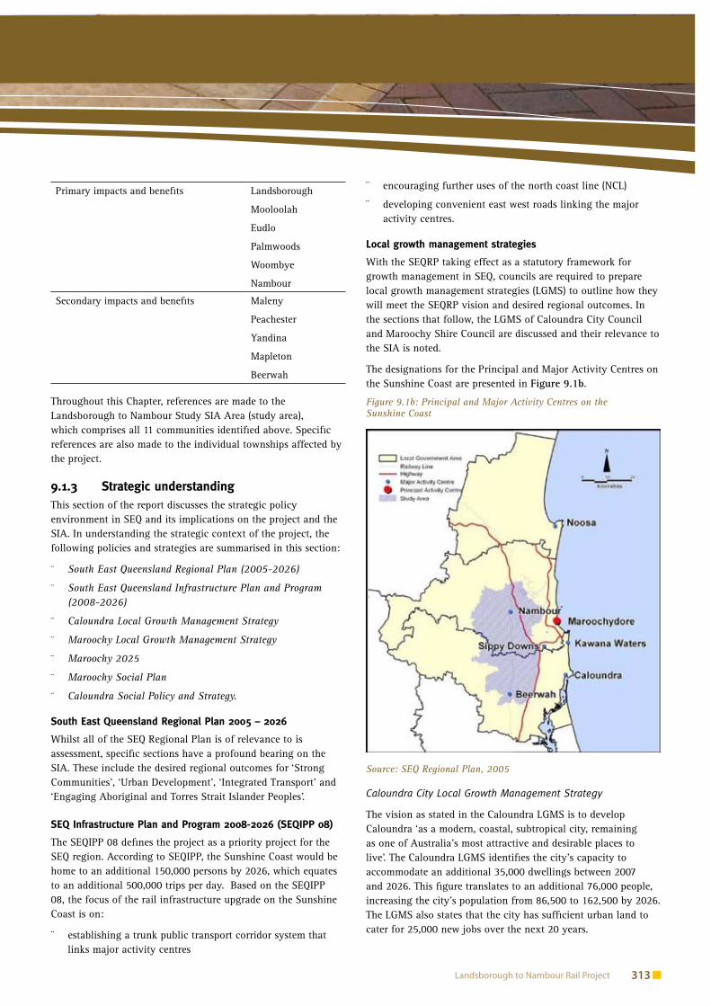
The designations for the Principal and Major Activity Centres on the Sunshine Coast are presented in Figure 9.1b.
Figure 9.1b: Principal and Major Activity Centres on the Sunshine Coast
Source: SEQ Regional Plan, 2005
Caloundra City Local Growth Management Strategy
The vision as stated in the Caloundra LGMS is to develop Caloundra ‘as a modern, coastal, subtropical city, remaining as one of Australia’s most attractive and desirable places to live’. The Caloundra LGMS identifies the city’s capacity to accommodate an additional 35,000 dwellings between 2007 and 2026. This figure translates to an additional 76,000 people, increasing the city’s population from 86,500 to 162,500 by 2026. The LGMS also states that the city has sufficient urban land to cater for 25,000 new jobs over the next 20 years.

Environmental Impact Statement 314
Social Environment9 9Caloundra’s hinterland communities that fall within the study area (Mooloolah and Landsborough) are within the urban footprint set by the SEQ Regional Plan. In terms of accommodating future growth, the LGMS allocates an extra 10,000 people to the hinterland communities by 2026. A large majority of this allocation is directed at Beerwah, which is designated as a Major Activity Centre in the SEQ Regional Plan. Total dwelling allocations for Beerwah between 2004 and 2026 is 1,800 dwellings, whilst the remainder of the hinterland communities have a total dwelling allocation of 2,700 dwellings over the same period. According to the Caloundra LGMS, the development intent of the hinterland communities is as follows:
Beerwah�� – As the Major Activity Centre (See Figure 9.1b), Beerwah will be developed as a low and mixed density residential housing in balance with the traditional character and identity of the town. Existing rural residential land suitable for urban residential will be developed accordingly.
Maleny�� – Greenfield areas in the Maleny Township is to be developed primarily for low density housing, consistent with the existing country town character and identity.
Other Hinterland Communities�� – Mooloolah and Beerburrum will be developed as low density neighbourhoods with the discrete rural town character and identity, whilst Landsborough and Glass House Mountains will be developed for low and mixed density residential housing.
Based on the Caloundra LGMS, the hinterland communities directly affected by the project (Mooloolah and Landsborough) are not areas earmarked for accommodating the additional 35,000 dwellings anticipated for Caloundra City over the next 20 years.
Maroochy Shire Local Growth Management Strategy
Maroochy LGMS was not signed off by the State government, due to the amalgamation of Maroochy council with Noosa and Caloundra councils in March 2008. However, the strategy was used to inform the development of a Sunshine Coast Regional Council Growth Management Position Paper. The document is still considered of interest to this assessment. According to Maroochy LGMS, the majority of growth in Maroochy Shire will be to the east of the Bruce Highway (i.e. coastal locations). The existing hinterland communities with the exception of Nambour will remain as low density neighbourhood residential, serviced by a village or a local centre. Designated as a Major Activity Centre under the SEQ Regional Plan, Nambour is expected to accommodate a significant proportion of the anticipated growth (through infill development), with details dependant to a degree on the outcome of Structure Planning for the Nambour Major Development Area (Nambour central).
According to Maroochy Shire Council, future urban growth will be distributed in a similar manner as the current planning scheme, the Maroochy Plan. According to the Maroochy Plan, the development intent of the communities that would be directly affected by the project includes:
Nambour – As a Major Activity Centre, Nambour will be a key centre for the provision of higher order goods and services to the hinterland and rural areas of Maroochy Shire. It will also provide a focus for a number of important industry, government and administration activities. The development intentions are to continue to develop Nambour as a contemporary hinterland town with a range of mixed housing options.
Woombye – Low density single detached dwellings will be the main form of dwellings in Woombye. Woombye is to maintain its rural character and identity.
Palmwoods – It is intended that Palmwoods will continue to maintain its character as a small country town with a range of goods and services provided to the residents of Palmwoods and surrounding rural areas. Although new residential development is expected within Palmwoods, the informal settlement pattern and the layout of the older parts of the town will be retained for their character and amenity.
Eudlo - The Eudlo Valley will be maintained as a predominantly rural landscape area, supporting a range of rural activities, low density rural residential development, conservation parks, extractive industry, low-key tourist facilities, and a business and industry node at Forest Glen.
As can be ascertained from the Maroochy plan, of the rail towns being affected by the project, Nambour and Palmwoods are the only two localities likely to experience substantial dwelling activity over the next 20 years.
Sunshine Coast Regional Council Growth Management Position Paper
The Position Paper (July 2008) provides council’s review of the SEQ Regional Plan 2005-2026 and a framework for future strategic land-use planning for the Sunshine Coast. The provision of fast, efficient and attractive public transport is stated as a priority.
The paper proposes to maintain most of the Regional Plan’s boundaries of the urban footprint and to make several amendments to the draft LGMSs which do not affect the project area.
Place making
A range of place making policies and strategies are in place at the local government level that are of relevance to this assessment. These include the Maroochy 2025, the Maroochy Social Plan and the Caloundra Social Policy and Strategy. Summaries of the relevant policies and strategies are presented below.
Maroochy 2025
Maroochy Shire Council delivered a series of community visioning process sessions in 2005. The visioning process, called Maroochy 2025, identified a common vision for the Maroochy

Social Environment9
Landsborough to Nambour Rail Project 315
Shire community: ‘Maroochy Shire will retain the beach and bush lifestyle of the Shire, and will seek to create a ‘green’ shire characterised by public transport connectivity, low energy and resource use, and sound environmental management’.
As outlined in Maroochy 2025, key focus areas for the Maroochy Shire community include:
Key Focus Area 1. The natural environment��
Key Focus Area 2. Health, vibrant, inclusive an learning ��community
Key Focus Area 3. Diverse transport, infrastructure and ��mobility
Key Focus Area 4. Responsible leadership and participatory ��decision making
Key Focus Area 5. Innovation and economy��
Key Focus Area 6. Smartly managed rural and urban futures.��
Under Key Focus Area 3, the Maroochy community envisions a future where there is reliable and affordable public transport that caters for all people in the community, and the availability of public transport infrastructure such as cycling networks, rail and light rail. A key action related to Key Focus Area 3 is developing transport corridors that facilitate the movement of people and wildlife. It is also recommended that community-specific access and mobility plans be prepared for each community, with a range of sustainable public transport options delivered to support the residents and their lifestyle.
Maroochy Social Plan
The former Maroochy Shire Council has prepared the Maroochy Community Profile and Community Facilities Strategy as part of its Social Plan. The other two components of the Social Plan, the Community Services Strategy and Community Wellbeing Policy, are currently being reviewed by council. The community facilities needs of communities within the shire are in line with the general population growth patterns, with Maroochydore and Nambour being identified as dominant centres for health, social, educational and government services. This direction is enforced through the SEQ Regional Plan, which identifies Maroochydore as a Principal Activity Centre and Nambour as the Major Activity Centre.
Caloundra Social Policy and Strategy
The former Caloundra City Council endorsed the Caloundra Social Policy and Strategy in 2004. The document provides a framework for planning of services and facilities that contribute to the wellbeing of communities in the former local government area (LGA). The Social Policy and Strategy outlines the following objectives:
to provide the policy framework in response to council’s ��Corporate Plan goals and desired outcomes for the social theme and other social issues
to provide a policy framework for council and the ��community in responding to and addressing existing and future needs or issues
to meet council’s requirements for relevant State and federal ��legislation and planning documents in relation to social and community issues.
In addition, the Caloundra Social Policy and Strategy are supported by an action plan, which seeks to ensure that the former LGA is:
a connected and involved community��
a learning community��
a safe and healthy community��
a community designed for living��
an inclusive community��
a creative and cultural community��
a community and Council partnership��
an enterprising community��
a community with diverse environments��
a well resourced community.��
To achieve the above policy outcomes, the Social Policy and Strategy also provide a list of facilities and services that are considered to be of priority for provision in the short, medium and long term periods. In terms of the hinterland communities, the Social Policy and Strategy identify a need for a mobile library service in Mooloolah and the development of the Cultural / Community Precinct along Mellum Creek in Landsborough.
Summary
A number of pertinent issues and considerations have been determined through the review of the relevant State and local government policies and strategies. The issues and considerations to be noted for the SIA are as follows:
The delivery of integrated public transport is a key regional ��outcome defined in the SEQ Regional Plan and as such, the upgrades to the NCL on the Sunshine Coast are identified as priority projects in the SEQIPP.
The project has the potential to contribute to the ��achievement of well connected communities by increasing the efficiency and frequency of rail services between activity centres on the Sunshine Coast.
Access to improved public transport services is considered a ��priority for communities on the Sunshine Coast.
The hinterland communities within the study area are ��unlikely to experience significant growth over the next 20 years, with the exception of Nambour and Beerwah (Major Activity Centres). However, the communities may expect further residential development beyond 2026. Based on the current planning intentions, future development within the

Environmental Impact Statement 316
Social Environment9 9study area are expected to complement the existing rural character and amenity of the communities concerned.
No major community infrastructure projects are identified ��for the study area. Major Activity Centres (Nambour and Beerwah) will continue to function as service centres for the hinterland communities on the Sunshine Coast, and future facilities and service provision will be directed to these activity centres.
Potential social costs and benefits of 9.1.4 the project
This section of the report provides a summary of the broad social costs and benefits of public transport corridors. A wide array of academic literature has been drawn to identify the likely social impacts and their relevance to the project.
Residential intensification
The development of a public transport corridor (particularly rail) or the improvement of an existing rail corridor can often lead to increased demand and/or opportunities for higher density development around stations. Increased densities around railway stations and/or in existing urban areas is known interchangeably as intensification, consolidation or densification (Burton 2000).
Research has shown that intensification around rail stations provide both benefits and costs to communities, including:
Benefits of Residential Intensification to Communities
improved access to facilities �
Households are in closer proximity to facilities and therefore there is a greater number of facilities per head of population.
improved access to jobs �
Residential intensification has been found to reduce the separation between home and work, and thus reduce time and costs of commuting. It is important that high density development is appropriately located on, or near public transport corridors to improve access to jobs and employment centres.
greater opportunities for public transport usage �
Higher density development is associated with greater use of public transport and less reliance on motor vehicle travel (i.e. mainly because of limited spaces for car parking in areas of high density development).
increased opportunities for walking and cycling. �
High density development has been found to increase opportunities for walking and cycling compared to low density development due to urban compactness and reduced distance between places.
Costs of residential intensification to communities
reduced access to green space �
Residents in high density areas are likely to live further away from the nearest area of green space. Contrary to common belief, a case study of suburbs in Sydney found that disadvantaged people were no worse off in having access to green space than other groups (Burton 2000).
reduced domestic living space. �
High density development leads to reduction in domestic living space, which can affect the quality of life of residents (Burton 2000). Therefore, it is important that residents living in high density development have access to a range of recreational, social and cultural facilities. For the Landsborough to Nambour Study Area, residential intensification is more likely to occur around rail towns designated as Major Activity Centres, namely Nambour and Beerwah.
Social advantage
Access to transport is an important aspect of community wellbeing. Having access to a range of public transport options facilitates social connectivity and mobility. However, areas on the urban fringe experience significant transport disadvantage because they are underserviced by affordable and frequent public transport services (Dodson and Sipe 2006). Households that have poor access to public transport are more likely to have a higher transport expenditure compared to those households located within close proximity to public transport. High transport costs, when added with other household expenses, can cause financial stress on households and limit their opportunity to participate in social, economic and recreational activities (Dodson and Sipe 2006).
A study of the relationship between transport and social disadvantage found that areas that are poorly serviced by public transport are likely to be disadvantaged because they have restricted connections to urban centres where the majority of social and employment facilities and services are located (Buchanan, Evans and Dodson 2005). Subsequently, urban areas that are serviced by frequent public transport services tend to be more advantaged than those areas with limited access to public transport, given their connections to activity centres and enabling greater access to employment opportunities.
The development of public transport corridors, if properly designed and managed, can lead to equitable outcomes for all social groups. If households have better access to public transport, there is less need to rely on motor vehicle transport, thereby reducing household costs on petrol, parking and other expenses associated with owning a motor vehicle (Dodson and Sipe 2006).
Therefore the proposed upgrade of the rail would provide benefits from a social advantage perspective.

Social Environment9
Landsborough to Nambour Rail Project 317
Community health and safety
The development of public transport corridors can lead to a number of health and safety benefits. Health benefits include increased opportunities for walking or cycling to and from public transport stations, and increased usage of public transport (and subsequently reducing motor vehicle usage). A study by Stokes, MacDonald and Ridgeway (2007) found that there are potential cost savings in public health that would be realised from public transport systems, such as:
reduced respiratory illness due to reduced pollution and ��increase in physical activity
a decrease in car accidents and vehicle operating costs��
cost savings associated with reduced travel times for public ��transport users.
Under the current Maroochy and Caloundra planning schemes, other townships within the study area are to maintain their existing residential density and form.
In addition to the above health benefits, public transport corridors can improve safety around stations as well as on transport infrastructure networks. Increased use of public transport results in less number of cars on the road, reducing the risk of road fatalities and accidents. As such, rail is considered to be a safer mode for transporting people and goods compared to the road system.
Another aspect of community safety with respect to public transport corridors is the need for ongoing surveillance to reduce personal and property crime around train stations. According to Loukaitou (2002) a number of previous studies have found that public transport usage is linked to people’s perception of crime and safety. Improved perceptions of safety can be achieved by appropriate planning and design of train stations. For example, designing car parking, drop off/pick up zones and connecting bus stops near train stations to increase the flow of pedestrian traffic can lead to greater surveillance and deter crime and consequently increasing train usage.
Housing affordability
Housing affordability within public transport corridors can vary depending on a range of variables at play. An American research conducted by Huang (1996) found that land near public transport stations return premium rents compared to land located away from the stations. The research findings were supported by another study undertaken by Knapp, Ding and Hopkins (2001), which found that rail investments increase land values in proposed station areas. The high property prices around existing or proposed rail stations can increase the viability of local businesses and the economic viability of the rail system, and increase the residential amenity of the area. However it is important that a mix of housing options is offered around stations to ensure that the benefits of public transport corridors are socially equitable, and that certain groups (i.e. low
socio-economic households) are not disadvantaged in terms of access to public transport, housing, employment and other essential infrastructure and services.
Social inclusion and connectivity
Providing people with better public transport can facilitate greater access to work, social networks and services, allowing them to participate more fully in society. Improvements in public transport can encourage social inclusion and interaction between and within communities. With this in mind, rail corridors require far less infrastructure when compared to road systems and therefore have a lesser impact on segregation of communities.
As mentioned in previous sections, public transport corridors provide access to employment, social and recreational opportunities. As noted by Dodson (2006), people living in outer suburban areas with poor transport services are locationally disadvantaged because of their limited access to employment. By providing better connections through improved public transport services can contribute to better connectivity between activity centres, and enable communities to access a range of facilities and services. In addition, there are opportunities to create vibrant community hubs around railway stations, which can become a focal point for community and cultural activities.
Social costs and benefits to be considered 9.1.5 in this SIA
The provision of efficient, functioning public transportation can have a major positive impact on social trends by encouraging residents’ travel habits and attitudes towards public transport. The movement away from dependency on motor vehicles reduces travel cost, reduces energy expenditure, increases social mobility and allows for greater densities. The following section outlines the general social trends and impacts associated with public transport provision. These trends and impacts will be used to assess the impacts for the SIA Study Area (as defined in Section 9.2).
Residential amenity
Although the residential amenity of a residential area may be adversely affected by the establishment of a new rail corridor, trends show that long term outcomes are likely to result in improved amenity and liveability of the residential area, especially through revitalisation and redevelopment around public transport corridors. Such improvements include the enhancement of streetscapes, public facilities, signage and other upgrades of physical and visual nature.
The development of the public transport corridor is likely to increase density around activity centres, particularly those that have the potential to provide jobs for the future population. As stated earlier in this section, residential intensification can increase property value around public transport nodes because of the desirability associated with being close to stations to access public transportation services.

Environmental Impact Statement 318
Social Environment9 9Public transport corridors can be considered to be part of a community asset, with a high value placed on the role that the corridors play in facilitating residents’ access to employment, health, education and recreational facilities, as well as contributing to the generation of wealth by transporting people from outside into the area. The community’s greater reliance on public transport may also encourage the formation of a sense of place focused on public transport infrastructure, such as a rail station and rail tracks.
Properties directly adjoining or within close distances to the public transport corridor are likely to be impacted by noise and air pollution. Although there may be a level of noise acceptance in areas where there is an existing corridor, property values near public transport corridors may be affected.
Well functioning public transport corridors increase commuter and station safety through surveillance and connectivity to surrounding businesses and community facilities.
Displacement and severance
In some instances, changes to or upgrades in public transport corridors can displace communities. In some cases, there is a danger for public transport corridors to physically divide the townships, if the corridor alignment is not carefully planned and designed in consultation with the local community.
The displacement of individual families can impact significantly on small townships where the loss of households can significantly alter the demographic composition of the town.
Access to facilities and services
Public transportation can improve residents’ access to essential facilities and services. For example, high frequency bus or train services are likely to reduce the time and cost taken to travel to key employment hubs.
Provided that the cost of travel for public transportation is affordable to all groups within a society, greater access could be achieved to enable people’s access to major health, education, cultural and sports and recreational facilities.
Appropriately designed transit stations and amenities are essential for the inclusion of people with a disability and parents with trams. It is important that people are able to access bus / train station in the first place in order to access the rail services.
Equity considerations
Effective public transport systems can reduce social isolation, provided that the public transportation services are affordable and accessible to various socio-economic groups.
Ensuring public transportation access can reduce social exclusion, namely by enabling disadvantaged groups to have increased geographic access to employment, educational and recreational opportunities.
Efficient public transport systems can result in travel time savings and increase travel experience of commuters. Travel experience on a higher speed rail line is likely to be of higher quality in terms of noise, vibration, odour, and vehicle fit out.
Demographic and social environment 9.2
This section of the report provides a broad demographic summary of the study area and demographic and social environments of the six communities that are directly affected by the project (Landsborough, Mooloolah, Palmwoods, Woombye and Nambour). The information presented in this section is sourced from the ABS Census data unless otherwise noted.
Character and residential amenity 9.2.1 The Landsborough to Nambour Study Area is predominantly of rural character, surrounded by rich natural landscapes and agricultural lands. The residential amenity of the study area is urban residential with communities surrounding the townships largely being of rural residential form. The communities in the study area have a distinct ‘country’ lifestyle and attributes, including village-type streetscapes and facilities.
The planning visions for the SIA study area are to maintain the hinterland identity of the communities. As such, the townships are to be developed to cater for the needs of their local communities. There is a strong intention to preserve the existing pattern of land use, such as having a village style centre in each township that provides local level facilities for social, recreational and retail services.
As noted in the SEQ Regional Plan, the existing planning schemes envision Nambour and Beerwah to be developed as the major service centres for the hinterland communities within the Caloundra and Maroochy LGAs. Whilst future residential development within the study area would be concentrated in these two townships, the planning schemes have allocations for ‘future urban development’ in certain townships outside of Nambour and Beerwah (e.g. Woombye).
Socio-demographic environment 9.2.2 The key issues and trends emerging from the baseline data for the study area include:
Population
The study area has a population of 54,702 at the time of the 2006 Census. This accounted for 19.8% of the population for the whole of Sunshine Coast.
The study area has a lower annual average growth rate over the 2001-2006 period when compared to the rest of the Sunshine Coast (2.2% compared to 3.3% for Caloundra LGA, 2.4% for Maroochy LGA and 2.5% for SEQ) as shown in Table 9.2.2.

Social Environment9
Landsborough to Nambour Rail Project 319
According to the planning studies conducted for the former Caloundra and Maroochy LGAs, the majority of forecast population growth over the next 20 years will occur in the coastal areas (which are outside the study area), and a relatively large population increases are expected for two hinterland localities in the study area (Nambour and Beerwah). Nambour and Beerwah are designated as Major Activity Centres under the SEQ Regional Plan.
The changes noted between the 2001 and 2006 Censuses showed that the study area has an ageing population in line with the trends for the Sunshine Coast region.
Indigenous Profile
Within the study area, 1.7% of the population identified themselves as being of Indigenous descent in the 2006 Census. This was slightly lower than in SEQ, where 1.8% of all respondents nominated as being of Indigenous descent.
Household Composition and Size
Couple families with children were the dominant family type across the study area. This was closely followed by couple families without children and one parent families. The study area’s pattern of household composition was similar to that of SEQ and Queensland.
The study area has a similar household size (2.7 persons per household) compared to SEQ (2.7 persons per household). However, there is generally a higher proportion of two person or more households in the study area compared to SEQ and Queensland, indicating that larger families are present in the study area.
School Attendance and Educational Attainment
The study area has a high proportion of residents currently attending primary (33.9% compared to 28% for SEQ) and secondary schools (23.5% compared to 19.6% for SEQ) but low proportions of residents attending TAFE and University (12.2% compared to 19.6% for SEQ).
The level of educational attainment is low for the study area compared to SEQ and Queensland, with the exception of Certificate qualifications.
Occupation and Income
Nearly one fifth (18%) of all people employed in the study area worked as technicians or trade workers. Other significant occupations within the study area included labourers and professionals.
The median weekly household income does not differ significantly between study area localities, with all localities apart from Landsborough having a median household income of $800-899. Landsborough households had a slightly lower median income of $650-799 per week. These figures were all slightly lower than the SEQ median weekly household income figure of $1,000-1,199.
Dwelling Type and Tenure
The study area has high levels of home ownership (35.3% of dwellings are fully owned and 38.4% of dwellings being purchased) compared to SEQ (30.6% and 35.9% respectively). Subsequently, there were low rates of rental tenure in the study area (20.7% of total dwellings) compared to SEQ (27.6%).
Separate dwellings was the dominant type of dwelling in the study area, with low proportions of semi-detached and attached dwellings (i.e. units, apartments, townhouses and duplexes) when compared to SEQ.
Housing Repayment and Rental Prices
The median home loan repayment was slightly lower in the study area ($1,215 per month) than it was in either Maroochy or Caloundra LGAs (the median repayment for both LGAs was $1,300 per month).
Rental prices in the study area were generally lower for smaller towns, but larger towns had comparable rental prices to Brisbane, Maroochydore and Caloundra.
Homelessness and Social Housing
Information on homelessness was not found for the SIA study area. The statistics below relates to the State.
The Australian Bureau of Statistics published a report titled ‘Counting the Homeless’ in 2006. There were 26,782 homeless people in Queensland in 2006. Half (49%) of the homeless in
Table 9.2.2: Average Annual Population Change, Study Area, Caloundra LGA, Maroochy LGA, SEQ and Queensland, 2001-2006
Study Area Caloundra LGA Maroochy LGA SEQ Queensland
Population 2001 49,113 74,393 126,745 2,372,104 3,585,639
Population 2006 54,702 87,597 142,839 2,680,531 3,904,532
Change from 2001 to 2006 5,589 13,204 16,094 308,427 318,893
% Average Annual Change 2.2% 3.3% 2.4% 2.5% 1.7%
Source: ABS Census of Population and Housing, 2001 and 2006

Environmental Impact Statement 320
Social Environment9 9Queensland were staying temporarily with other households. Queensland had 20% people in boarding houses, just under one-fifth (19 %) in improvised dwellings, tents or sleepers out, and about 12% in Supported Accommodation Assistance Program (SAAP).
Social housing in the project area is concentrated in the towns of Palmwoods, Woombye and mainly Nambour.
Transport
Households in the study area were automobile dependent, with very low levels of public transport used as a main mode of travel to work.
A detailed demographic and social profile of the Landsborough to Nambour Study Area can be found in Appendix F of this report.
An analysis of the study area’s townships 9.2.3 This section provides a broad overview of the social characteristics and lifestyle attributes of the six townships that fall into the study area. Specifically, this section will cover the following:
residential amenity��
community vision��
existing demographic and social environment��
community infrastructure and services.��
Table 9.2.3 summarises these factors for each township.
Table 9.2.3: Townships Social Characteristics
Landsborough
Residential Amenity Landsborough is characterised by its historical character with many sites of cultural heritage value located within the township. Functioning as an entrance to the Blackall Range, Landsborough has a sufficient business centre catering for residents and tourists.
Residential development in Landsborough is urban with residential areas situated immediately to the north and west of the business centre. The area is characterised by low rise detached dwellings on suburban lots with an exception of the Corella Park residential estate which is intended for allotments of 1,000 m2.
Landsborough is connected to reticulated water and sewerage. According to council, these services have the capacity of being extended to new residential areas.
Community Vision The community vision for the Landsborough Township is to maintain its identity as a small rural town and to preserve its historical character and buildings. It is envisaged that Landsborough would continue to be a residential community with the local business centre functioning to service the needs of residents in Landsborough and surrounding areas.
Existing Demographic and Social Environment
Population
The population of Landsborough was 1,576 in 2006. This was an increase of 13.1% compared to the 2001 population figure of 1,393.
Indigenous Profile
The proportion of Indigenous persons was higher in Landsborough than the study area at 2.4% compared to 1.7%. The share of non-Indigenous persons was similar between Landsborough and the study area at 94.2% and 94.4% respectively.
Household Composition and Size
Landsborough contains a lower proportion of families with no children than the study area with 34.3% of total families falling into this category compared to 39.7% in the Landsborough to Nambour Study Area. Proportions of families with children were similar to the study area however cases of one parent families with children was higher in Landsborough accounting for 20.1% whereas this figure was only 15.7% in the study area.
The average household size was the same for both Landsborough and the study area at 2.7.
Occupation and Income
The resident work force contained a large proportion of construction related occupations with labourers comprising the largest share of the occupational breakdown at 22.5% of all workers. The occupation with the next highest share was technicians and trade workers which accounted for 20.2% of all employed residents.
The three largest industries by proportion of workers were construction at 15.7%, health care and social assistance at 10% and retail trade accounting for 9.9%. These industries were also the three largest in the Landsborough to Nambour Study Area.
The median weekly individual income in Landsborough was $250-$399. There were higher proportions of persons earning less than $1,000 in Landsborough and conversely less earning above $1,000 when compared to the study area.

Social Environment9
Landsborough to Nambour Rail Project 321
Landsborough
Existing Demographic and Social Environment cont.
Dwelling Type and Tenure
As expected, the dwelling structures of Landsborough are dominated by separate houses accounting for 87.5% of all dwellings. Proportions of semi detached and attached dwellings were both lower in Landsborough than in the study area. Other dwellings, which include dwellings such as caravans, demountable homes, tents accounted for 9.4% of total dwellings in Landsborough and only 3.4% in the study area.
Home ownership was low in Landsborough with 29.7% of dwellings falling in this category compared to 35.4% for the study area. On the contrary, Landsborough had a high proportion of households being rented (29.2%) than the study area as a whole (22.5%).
Housing Repayment and Rental Prices
The median weekly housing loan repayment in Landsborough was comparable to the study area as a whole. In 2006, the median home loan repayment was $1,129 in Landsborough and $1,215 in the study area.
Over 55% of households were paying rent of between $180 and $274 per week.
School Attendance and Educational Attainment
Landsborough contained a greater share of persons attending primary school at 35.9% compared to the study area (33.9%). Proportions of secondary students was approximately equal that of the study area at 23.32% and 23.5% respectively.
Compared to the study area, there were lower proportions of Landsborough residents with non-school qualifications, including bachelor degree (7.7% and 15.5% for the study area) and diploma holders (11.0% and 14.6% for the study area).
Community Infrastructure and Services
Landsborough has a community node located to the south of Maleny Street, consisting of a community hall, neighbourhood centre and historical museum. The township is also serviced by:
Landsborough State Primary School
Child care centre
Kindergarten
Emergency services
A small magistrates court
The Landsborough Sport and Recreation Complex (a district level facility) and numerous parks are also located within the area.
Mooloolah
Residential Amenity Mooloolah is characterised by urban and rural residential development. Low density detached housing is the dominant type of dwelling in the area. The majority of dwellings within the township are on small suburban lots whilst the surrounding rural residential area accommodates detached dwellings on lots of over 1,000 m².
The Mooloolah business centre is intersected by the north coast line, and it caters for the residents of the township and surrounding rural residential communities. Mooloolah is connected to reticulated water and sewerage.
Community Vision The vision is for Mooloolah to retain its distinct identity as a rural community with the local business centre catering for the needs of residents within Mooloolah Valley. Based on the Caloundra City Planning Scheme, there is an intention for Mooloolah to have a strong sense of place reinforced through residents’ active participation in community activities, and the protection of natural and rural character which attracts people to Mooloolah in the first place.
Existing Demographic and Social Environment
Population
The population of Mooloolah at the time of the 2006 Census was 1,132 which was an increase of 15.6% from the 2001 figure of 979.
Indigenous Profile
Mooloolah had a similar proportion of Indigenous persons residing in the area (1.6%) compared to the study area (1.7%).
Table 9.2.3: continued
Environmental Impact Statement 322
Social Environment9 9Mooloolah
Existing Demographic and Social Environment cont.
Household Composition and Size
The two largest family types in the town of Mooloolah Valley were couple families. Couple families with children composed 49.3% of the total families in the town, while couple families without children composed 31.6%. One parent families also made up approximately 17.8% of the town’s families.
The average household size in Mooloolah was 3.0. This was higher than the average recorded for the Landsborough to Nambour Study Area at 2.7.
Occupation and Income
The dominant occupation in Mooloolah was technicians and trade workers, representing 20.3% of the employed population. This is followed by clerical and administrative workers (13.7%) and labourers (12.2%).
Construction (18.3%) and retail trade (14.4%) were the two dominant industries in which residents of Mooloolah were employed. Mooloolah also had a large proportion of people working in healthcare and social assistance, and manufacturing industries (11.3% and 8.7% respectively).
In Mooloolah, the median individual income was $400-$599 per week.
Dwelling Type and Tenure
The separate house is by far the dominant dwelling type in both Mooloolah and in the study area. In Mooloolah, 97.4% of all dwellings were separate houses, while in the study area the proportion was slightly lower at 86.8%.
Given the clear dominance of separate dwellings, there were no semi-detached dwellings recorded and a very low proportion of attached dwellings in Mooloolah. Other dwelling types (including improvised and makeshift dwellings) also represented a very small proportion of dwellings, with these being proportionately underrepresented when compared against the Landsborough to Nambour Study Area.
Nearly half (47.2%) of all occupied private dwellings in the town of Mooloolah were being purchased at the 2006 Census. This was the largest tenure type in the town, ahead of outright ownership (29.0%) and renting (22.2%).
Housing Repayment and Rental Prices
Housing loan repayments were slightly lower in Mooloolah than they were in the Landsborough to Nambour Study Area. The average housing loan in Mooloolah Valley was $1,202 per month, while in the study area the average was $1,215.
Based on the 2006 Census, the median rental price for Mooloolah was $240 per week.
School Attendance and Educational Attainment
Mooloolah had slightly higher proportions of people pre-school (7.7%) and primary school (35.8%) than in the study area (5.5% and 33.9% respectively).
In comparison to the study area, Mooloolah had a significantly higher proportion of people with postgraduate degrees (1.8% compared to 0.8% for the study area).
Community Infrastructure and Services
Mooloolah has a limited range of community and education facilities that service its residents and surrounding communities. The following facilities are located within Mooloolah:
Mooloolah Primary School
Kindergarten
Community hall
Fire station
Pony club
The Mooloolah township is also a location for open space reserves of Mooloolah Recreation Ground, Suzen Court, South River, Marie Higgins Conservation Park, Village Green and Martin Rungert Park.
Table 9.2.3: continued

Social Environment9
Landsborough to Nambour Rail Project 323
Eudlo
Residential Amenity Eudlo is a small country town that serves as a hub for the surrounding rural community. The area consists of good quality agricultural land (identified in the Caloundra City Plan) and natural features of significant environmental value (e.g. Eudlo Creek, the Eudlo Creek National Park, and the Eudlo Creek Conservation Park). Residential development in Eudlo is characterised by low density rural residential lots. Aside from residential uses, Eudlo has allocations for tourist and extractive industry uses, whilst the remaining parts of Eudlo are identified for general rural activities.
Community Vision The community’s vision for Eudlo is to retain the township’s current population, physical size and service capacity. The Maroochy Plan’s intent is to maintain Eudlo’s rural landscape and existing land uses (i.e. general rural activity, rural residential development, conservation parks, tourist facility, extractive industry and a business and industry node at Forest Glen). Aside from local open space and community facilities currently available in the area, the Eudlo community is of acceptance that residents would have to travel to larger centres to access higher order goods and services.
Existing Demographic and Social Environment
Population
According to the 2006 Census, the population of Eudlo was 175. Unlike other communities in the study area which experienced an increase in population between 2001 and 2006, the change in the population of Eudlo during this period was -5.91% (a loss of 11 people).
Indigenous Profile
Based on the 2006 Census, no resident in Eudlo identified themselves as being Indigenous.
Household Composition and Size
Couple families with children were the dominant family type in Eudlo, representing 46.7% of all families. This trend was consistent with the study area, where couple families with children accounted for 43.6%. However, in contrast to the study area, Eudlo had a relatively low proportion of couple families with no children (15.6%) and a relatively high proportion of one parent families (37.78%) when compared with the Landsborough to Nambour Study Area (39.7% and 15.7% respectively).
The average household size (in Eudlo in 2006 was recorded as 2.6, which was slightly smaller than the study area (2.7 persons per household).
Occupation and Income
Eudlo has a significantly higher proportion of labourers (16.9%), machinery operators and drivers (12.1%), community and personal service workers (12.1%), and technicians and trade workers (25.3%) when compared against the Landsborough to Nambour study area.
Consistent with the occupational profile, Eudlo had a significantly higher proportion of residents working in construction, and transport, postal and warehousing. Eudlo also had a high proportion of workers in education and training, and agriculture, forestry and fishing.
The median weekly individual income in Eudlo was $400-$599.
Dwelling Type and Tenure
A significantly higher proportion of all occupied dwellings in Eudlo (55.6%) were being purchased than were in the Landsborough to Nambour Study Area (38.8%). In contrast, notably lower proportions of dwellings were fully owned (22.2% compared with 35.4%), while the same proportion of dwellings were being rented (22.5%), when the Eudlo was compared against the study area.
The separate house is by far the dominant dwelling type in Eudlo with 93.7% of all dwellings being separate houses.
Housing Repayment and Rental Prices
Housing loan repayments were significantly lower in Eudlo than they were in the study area. The average housing loan in Eudlo was, $1,105 per month, while in the study area the average was $1,215.
While Eudlo had the same proportion of dwellings being rented as the study area, the low absolute figure that this represents (12) means that the data that can be inferred from rental payments is relatively limited.
School Attendance and Educational Attainment
A slightly higher proportion of the residents in Eudlo attend pre-school (7.8%), primary school (41.2%) or TAFE (13.7%) than in the study area (5.5%, 33.9% and 5.9% respectively).
In regard to educational attainment, slightly higher proportions of people in Eudlo were recorded as possessing a graduate diploma and/or graduate certificate (6.1%), or a diploma or advanced diploma (18.2%) compared to the study area (2.4% and 14.6% respectively). A significantly higher proportion of residents were recorded as possessing a certificate qualification (59.1%) when compared to the Landsborough to Nambour Study Area (41.8%).
Table 9.2.3: continued

Environmental Impact Statement 324
Social Environment9 9Eudlo
Community Infrastructure and Services
Only a limited range of community facilities are provided for in Eudlo. These facilities include:
Eudlo Primary School �
Eudlo skate park �
Horse and pony school �
Public hall �
Eudlo recreation grounds �
Higher order facilities and services are accessed by Eudlo residents in nearby district and regional centres (i.e. Palmwoods and Nambour).
Palmwoods
Residential Amenity With the presence of heritage buildings that contribute to the historical and country style character of the township, Palmwoods is comprised predominantly of low density residential development on land designated for urban uses. There is capacity within the current planning provisions to accommodate new greenfield developments, which are to be master planned and will be subject to the preparation of a Local Area Structure Plan, or other detailed Plan of Development as approved by Council.
Community Vision The vision of the community is to preserve and enhance the existing historic buildings within the Palmwoods township, and maintain the level of goods and services provided to the residents of the town and surrounding rural and rural residential areas. Although new residential development is expected within the area, the existing settlement pattern and layout of the older parts of the town would be maintained as key elements of character and amenity. Complementing the town’s historical character will be the preservation of an attractive green space which currently traverses the town.
Existing Demographic and Social Environment
Population
The population of Palmwoods at the time of the 2006 Census was 2,622, which was an increase of 13.9% compared to the 2001 figure of 2,302.
Indigenous Profile
Indigenous people accounted for 1.6% of the total population in Palmwoods. This was relatively consistent with the low proportion of 1.7% of residents who identified themselves as being Indigenous within the study area.
Household Composition and Size
The township of Palmwoods recorded a slightly lower proportion of couple families with children than the Landsborough to Nambour study area as a whole. In contrast, a higher proportion of one parent families were recorded in Palmwoods (17.8%) than in the study area (15.7%).
The average household size in Palmwoods was 2.7, which is the same as that of the study area.
Occupation and Income
The dominant industries of employment in Palmwoods were construction (13.7%), retail trade (14.1%) and health care and social assistance (13.3%). The town was also strongly represented in the education and training, and manufacturing industries.
The most common occupations in Palmwoods were technicians and trade workers (16.6%) and professionals (16.2%). This compared to 18.0% and 14.8% respectively.
The median weekly individual income in Palmwoods was $250-$399.
Dwelling Type and Tenure
At the time of the 2006 Census, 40.0% of all occupied private dwellings in Palmwoods were in the process of being purchased. This was the largest tenure type in Palmwoods, just ahead of outright ownership (30.0%) and renting (21.6%).
In Palmwoods, 88.5% of dwellings are separate houses, while in the Landsborough to Nambour Study Area, the proportion is slightly lower at 86.8%.
Housing Repayment and Rental Prices
Housing loan repayments were marginally lower in Palmwoods than they were in the Landsborough to Nambour Study Area. The average housing loan in Palmwoods was $1,163 per month, while in the average for the study area was $1,215.
The majority of households in rented dwellings were paying between $225-349 per week for rent.
Table 9.2.3: continued

Social Environment9
Landsborough to Nambour Rail Project 325
Palmwoods
Existing Demographic and Social Environment cont.
School Attendance and Educational Attainment
Compared to the study area, slightly higher proportions of people were currently attending pre school (7.0%), primary school (36.1%), TAFE (8.0%) or university (6.3%) than in the study area.
Palmwoods had a relatively similar distribution of non-school qualifications to the Landsborough to Nambour Study Area with residents with graduate diplomas accounting for 3.3%, those with bachelor degrees being 16.84%, those with advanced diplomas being 16.3% and residents with certificates accounted for 42.7% of residents.
Community Infrastructure and Services
Servicing for its residents and surrounding rural and rural residential communities, Palmwoods has the following facilities and services:
Palmwoods State School �
Community pool �
Community hall �
Places of worship �
Police station �
Rifle range �
Showgrounds �
In addition, located within the township are open space facilities such as Jubilee Park, Briggs Park, Kolora Park and Federation Park.
Woombye
Residential Amenity Woombye is a discrete residential area characterised by low density detached housing. Due to its proximity to Nambour, the business centre in Woombye has a limited range of facilities and services catering for its residents and surrounding pockets of rural residential communities.
Woombye is surrounded by rural landscape, featuring rolling hills, natural bushland and small farms.
Community Vision The vision is to maintain and strengthen the discrete identity of Woombye to distinguish this community from Nambour. Similarly, Woombye is to maintain its lifestyle and heritage values. The Maroochy Plan identifies land for future urban uses within the Woombye planning area.
Existing Demographic and Social Environment
Population
At the time of the 2006 Census, Woombye had a population of 812 persons, which was equivalent to an increase of 12.6% from the 2001 Census population figure of 721. This increase was higher than the growth recorded for the study area (11.38%).
Indigenous Profile
The proportion of non-Indigenous population in Woombye was similar to that of the study area (94.8% and 94.4% respectively). Indigenous people accounted for 2.1% of the total population compared to 1.7% in the study area, indicating a higher proportion of Indigenous people residing in Woombye.
Household Composition and Size
Proportions of families with children including couple parents and single parent families residing in Woombye were both higher than that of the study area (45.2% compared to 43.6% and 17.5% compared to 15.7%) whilst the proportion of couple families with no children was lower (36.0% compared to 39.7%). The high proportion of families with children in Woombye is likely to be due to its close proximity to schools located in Nambour and surrounds.
The average household size in Woombye was 2.6 persons per household which was slightly lower than that of the study area at 2.7 persons per household.
Occupation and Income
The most common occupations for Woombye residents were labourers (18.2% of employed persons), technicians and trade workers (17.9%) and professionals and sales workers (13.9%).
The dominant industries in Woombye were retail trade (16.3%), construction (11.2%), manufacturing (8.8%) and health care and social assistance (9.1%). Proportions of employed persons who work in the retail industry were higher in Woombye at 16.3% than in the study area at 13.1%.
The median individual income in Woombye was $400-$599. Woombye contained greater proportions of households who earn high incomes, specifically between $1,400 and upwards. The median household income for Woombye and the study area was $1,000-$1,199 per week.
Table 9.2.3: continued

Environmental Impact Statement 326
Social Environment9 9Woombye
Existing Demographic and Social Environment cont.
Dwelling Type and Tenure
Dwelling tenure in Woombye indicates greater proportions of fully owned and rented properties, with fewer properties in the process of being purchased when compared to the study area. In Woombye, 39.7% of dwellings were reported as being fully owned compared to 35.4% in the study area. Households who were renting a dwelling accounted for 28.2% of all households in Woombye compared to 22.5%.
Separate houses accounted for the majority of dwelling types in Woombye which included 91% of all households which was higher than 86.8% in the study area. The proportion of semi detached dwellings was slightly higher in Woombye at 5.45% than the study area at 3.3%.
Housing Repayment and Rental Prices
Monthly home loan repayments in Woombye were slightly higher than repayments made in the study area, with on average $1,300 being paid per month in Woombye compared to $1,215 in the study area.
Based on the available data from the 2006 Census, the majority of rents paid by households in Woombye was between $140 and $499 per week.
School Attendance and Educational Attainment
According to the 2006 Census, the proportion of Woombye residents attending pre-school was 7.1%, those attending primary school was 33.3% and those attending secondary school was 24.3% (compared to 5.5%, 33.9% and 23.5% for the study area respectively).
Woombye residents were more likely to be attending a tertiary institution compared to the study area as a whole. Those who were attending TAFE accounted for 7.1% in Woombye (5.9% in the study area) and those attending university comprised 8.1% of Woombye residents (6.3% in the study area).
Certificate qualification was the most common type of education attained by Woombye residents (40.0%) although proportionally, it was lower than the study area (41.8%). With postgraduate qualification, a higher proportion of Woombye residents held a postgraduate degree (3.6%) compared to the study area (2.0%). It is likely that the lifestyle of the area attracts qualified professionals who commute to larger centres for employment.
Community Infrastructure and Services
The facilities and services located within Woombye include the following:
Woombye State School �
Suncoast Christian College �
Woombye Showgrounds �
Community Library �
Masonic Centre �
Residential Care and Community Aged Care �
Places of worship �
Horse and Pony Club �
Soccer Club �
There are also park and recreational spaces including Paynter Park, Memorial Park, CWA Park, Junee Crescent Park and McCarthy Drive Park.
Nambour
Residential Amenity Nambour is the largest residential community in the Maroochy hinterland. The town is set against a natural landscape of hills and hillside vegetation. Residential development within Nambour is of low and medium density.
As a geographic centre of the former Maroochy shire, Nambour provides higher order goods and services to residential community in the hinterland and rural parts of the shire. These include medical and educational facilities which are considered to be district and regional level facilities.
Community Vision Given its current function as a local government administrative centre, Nambour has been designated as a Major Activity Centre under the SEQ Regional Plan. Future development within Nambour will be in line with this activity centres designation with mixed use development dominating the town core. The Sunshine Coast Regional Council is currently in the process of implementing the Nambour revitalisation project to facilitate the development of Nambour as a Major Activity Centre.
Table 9.2.3: continued

Social Environment9
Landsborough to Nambour Rail Project 327
Nambour
Existing Demographic and Social Environment
Population
Nambour’s population increased from 12,782 in 2001 to 14,121 in 2006, which equated to a percentage change of 10.5%, slightly lower than the change recorded for the study area for the same period (11.4%).
Indigenous Profile
Indigenous persons accounted for 2.7% of the population, which was higher than that of the study area (1.7%).
Household Composition and Size
Couple families without children accounted for the majority of all families in Nambour (39.1%) whilst couple families with children accounted for 38.7%. Compared to the study area, Nambour had a higher proportion of single parent families (20.7%) than the Landsborough to Nambour Study Area (15.7%).
The average household size in Nambour was 2.48. This was lower than the average recorded for the Landsborough to Nambour Study Area, which was 2.69 persons per household.
Occupation and Income
The dominant industries of employment for Nambour residents were health care and social assistance (16.7%) and retail trade (14.6%). These industries were proportionally higher in Nambour when compared with the study area (12.8% and 13.1% respectively). Nambour was also strongly represented in the construction, and manufacturing industries.
The dominant occupation in Nambour was technicians and trade workers, representing 17.9% of the employed population. This is followed by labourers (15.8%), with machinery operators and drivers the least prevalent occupation in Nambour (6.9%).
The median weekly individual income in Nambour was $250-$399. Nambour was proportionately underrepresented in all income brackets above $1,200 per week compared to the study area.
Dwelling Type and Tenure
Separate house was by far the dominant dwelling type in Nambour. In Nambour, nearly four in every five dwellings (78.4%) were separate houses, while separate houses accounted for 86.8% of all dwellings in the study area. In contrast, semi-detached dwellings represented 5.9% of dwelling stock in Nambour, compared to 3.3% for the Landsborough to Nambour Study Area.
One third of all occupied private dwellings in the town of Nambour were being purchased at the time of the 2006 Census. This was the largest tenure type followed by renting (accounting for a slightly lower proportion of dwellings at 31.3%) followed by full ownership (30.8%). Compared to the study area (22.5% and 35.4%), Nambour had a higher proportion of rented dwellings. This is likely to be due to Nambour having a lower median rental price in comparison to other localities in the Local Government Area.
Housing Repayment and Rental Prices
Housing loan repayments were significantly lower in Nambour than they were in the Landsborough to Nambour Study Area. The average housing loan in Nambour was $1,115 per month, while in the Landsborough to Nambour Study Area, the average was $1,215.
Generally, rents are cheaper in Nambour than they are in the Landsborough to Nambour Study Area. According to the 2006 Census, more than a quarter (28.7%) of rented dwellings in Nambour cost less than $140 per week compared to 24.3% of dwellings in the Landsborough to Nambour Study Area. Similarly, Nambour had the lowest median weekly rental price compared to other townships in the study area.
In contrast, there are comparatively few rented dwellings in Nambour that cost between $275 $349 per week and just 1.5% that cost over $350. In contrast, in the Landsborough to Nambour Study Area 14.5% of all rented dwellings cost between $275-349 per week, and 3.0% that cost over $350 per week.
School Attendance and Educational Attainment
Slightly lower proportions of Nambour residents were attending a pre-school, primary school or secondary school when compared to the Landsborough to Nambour Study Area. However, of the persons attending an educational institution in 2006, a higher proportion attended both TAFE and University while living in Nambour than did in the Landsborough to Nambour Study Area. This may be attributable to the close proximity of Nambour to the Sunshine Coast TAFE and the Sunshine Coast University and the availability of affordable rental housing in Nambour.
With regard to educational attainment, Nambour had a slightly lower proportion of persons with a certificate (41.5%) compared to the Study Area (41.8%). Similarly, the proportion of Nambour residents with an advanced diploma or diploma degree was lower (13.6%) compared to that of the study area (14.6%).
Table 9.2.3: continued

Environmental Impact Statement 328
Social Environment9 9Nambour
Community Infrastructure and Services
A wide range of community infrastructure and services are found in Nambour, including: Nambour State Schools �
Nambour Christian College �
TAFE �
Places of worship �
Nambour Library �
Civic Centre �
Neighbourhood Centre �
Visual and Performing Arts Facility �
Showgrounds �
Horse and Pony Club �
Hospital and allied services �
Recreational facilities and parks within Nambour include Petrie Park, Moss Day Park, Huntingdale Park, Jubilee Park and Koala Park.
Information provided by the community9.3
Throughout the project, there has been on-going community consultation. Details of activities and information releases are discussed in Chapter 1, Section 1.9. Issues raised to date and considered in both the route identification process and the assessment of the impact of the project are discussed in Table 9.3.
Table 9.3: Community Feedback, related to Social Impacts
Issues Raised Response Section Where This Issue is Addressed
Possibility of leaving the level crossing intact in Mooloolah, so as to avoid division of the town centre and commercial hub.
Further consultation has been undertaken to involve the community in the design and staging of the project. Preservation of a grade separation option to the south of the open level crossing utilising Jones Street has been identified for future implementation at such time as risk and traffic congestion considerations determine the need for its closure.
Chapter 21, Special Management Areas
Impact of the project on land availability and housing affordability
The impact on housing availability and affordability is expected to be positive in the long-term, as the project will generate growth in the townships and allows for greater density in proximity to the stations.
Section 9.10.4
Social impact assessment 9.4
Methodology 9.4.1 This final section of the chapter presents the social impact assessment and associated mitigation strategies for the project.
The outcomes have been derived through a synthesis of findings from the socio-demographic baseline, review of relevant policies and literature, and community values survey conducted during the initial phase of the study. This information has been updated with community feedback from varying periods during the study process.
Social impacts and associated risks 9.4.2 This section presents the potential social impacts of the project on the local and regional communities. Based on the information from the baseline assessment and community consultation, the likely positive and negative impacts include:
impacts on community values and aspirations��
impacts on demand and supply of housing��
impacts on community wellbeing��
impacts on residents’ access to community facilities and ��services, and open space.
Impacts on property, including the value of affected properties, are discussed broadly in this section however this is addressed in Chapter 8, Economic Environment.
Table 9.2.3: continued
Social Environment9
Landsborough to Nambour Rail Project 329
Likely impacts on community values and 9.4.3 aspirations
The communities located within the project area, with the exception of Nambour, are cohesive communities consisting of small populations. The communities within the study area have a strong identity linked to their agricultural and rail heritage, surrounding natural environment and lifestyle attributes. The potential impacts on the local community identity and lifestyle values identified for the project include the following:
Generally, the project is likely to deliver positive impacts on localities that have been identified to accommodate future population growth (i.e. Mooloolah, Palmwoods, Woombye and Nambour). As these localities have a strong identity centred on the rail line, the project is likely to enhance their identity as a ‘rail town’ and create opportunities for improved business and community activities around the rail stations. However, road realignments and the loss of the existing station buildings and associated infrastructure will impact on the character on the townships. This impact is discussed in more detail in Chapter 21, Special management areas, the visual impact is assessed in Chapter 6, Landscape character and visual amenity and the impact on cultural heritage in Chapter 10, Cultural heritage.
The project in Landsborough follows the existing rail alignment and therefore is likely to cause minimal impact on the identity and character of the Landsborough locality. Based on the findings from the Community Values Survey conducted as part of the Landsborough to Nambour Rail Corridor Study Route Identification Report (2008), Landsborough’s identity as a ‘rail town’ is likely to be enhanced through the project with opportunities to maximise community uses of land surrounding the train station to reinforce the historical significance of the Landsborough train station. This will have a cumulative beneficial impact on the township with the Landsborough Art, Community and Heritage Precinct discussed in Chapter 3, Land use and infrastructure.
The project in the Mooloolah segment follows the existing alignment. The Mooloolah residents’ preference to live on a large property is likely to be maintained as a lifestyle value. Community consultation has shown that the width of the corridor (which has been reduced as a result of the community consultation) and potential grade separation were perceived as detrimental impacts to the character of the township. Further consultation was conducted to engage the local community through the design of the project. This consultation resulted in a reduction of the corridor width and preservation of a grade separation option to the south of the open level crossing (OLC) until such time as risk and traffic congestion considerations determine the need for closure of the OLC. This is discussed in more detail in Chapter 21, Special management areas.
In the Eudlo segment, the project has been identified as impacting on Eudlo Creek National Park. Given that the Eudlo residents consider the natural environment as a key attribute to the locality, the project is likely to have a negative impact on residential amenity and lifestyle values. There is an opportunity for mitigating negative impacts through community development activities and ongoing engagement of the local community in the planning, design, construction and operation stages of the project.
In Eudlo township, the project could impact on the trees planted by the local Landcare group at Federation Walk to meet the project’s safety and access requirements or to redevelop the area surrounding the new station.
In Palmwoods, the railway will be on structure to the north of the station. The structure will minimise the impact on public facilities of high community value, such as Kolora Park. Although the park is preserved, the visual impact of the structure on the park’s amenity could be significant and is discussed in Chapter 6, Landscape character and visual amenity and Chapter 21, Special management areas.
The project runs through the soccer fields located to the west of Woombye township. This has the potential to impact on the community’s values and aspirations. The involvement of the local community in the selection of an appropriate relocation of the facilities is required.
The project for the Nambour segment is closely aligned with the existing rail track and with Nambour being a larger urban centre compared to the other communities in the study area, the impacts on the local community identity and lifestyle values are likely to be positive in reinforcing Nambour’s role as a Major Activity Centre serving the needs of the surrounding hinterland and rural communities.
At the regional level, the project is likely to have a positive impact on achieving the Desired Regional Outcomes (Integrated Transport and Strong Communities) outlined in the SEQ Regional Plan by improving north-south accessibility and delivering integrated transport outcomes to communities on the Sunshine Coast.
Likely impacts on demand and supply 9.4.4 of housing
Generally, the project is likely to have some impacts on property values in the short to medium term especially for properties directly adjacent to the proposed rail corridor. In the long term, property values are likely to increase as accessibility to high frequency rail services become more desirable and living close to the rail line becomes an accepted part of the lifestyle for rail town communities.
The reduction in land availability for housing as a result of a wider corridor was raised during the public consultation process. The corridor width has since then been reduced in Mooloolah

Environmental Impact Statement 330
Social Environment9 9and in Palmwoods where the railway will be on structure. In addition, surplus rail land would be available for urban uses following the decommissioning of the existing corridor. The new rail corridor will affect approximately 64 hectares of urban footprint, with around 6 hectares of surplus rail corridor land made available for reuse in the townships. The reduction of land availability is likely to be mitigated in the long-term through the likely growth of the townships generated by the improvements to the passenger rail service and the potential increase in densities in close proximity to the train station.
Population growth and associated dwelling activity are impacts that are likely to result from the implementation of the project when compared to the ‘do nothing’ (or business as usual) situation. Although the planning intent for the existing rail towns does not envision the towns to accommodate a large proportion of growth expected for the Sunshine Coast region (with the exception of Nambour), it is likely that the population of the hinterland communities is likely to increase well beyond 2026 as the coastal localities become fully developed and more people move inland to seek the ‘tree change’. Evidence from contemporary literature also shows that residential intensification is likely in areas that are serviced by mass public transport systems and these areas become highly desirable places to live. Whilst immediate and short term negative impacts on the visual amenity and physical movements within the affected localities will be inevitable, long term impacts are likely to be positive, with potential opportunities for improvements in residential amenity and liveability through the enhancement of streetscapes, public spaces and business activity around the train stations. With this in mind, the positive and negative impacts of the project in terms of housing demand and supply include the following:
The project in Landsborough is likely to have a positive ��impact on housing supply as opportunities exist for a diverse range of housing types and tenure options are likely to be delivered within the Landsborough town centre and surrounding areas. Landsborough’s close proximity to Activity Centres located along the rail line to the south (i.e. Beerwah, Morayfield/Caboolture and Brisbane) and to the north (i.e. Nambour) is likely to increase the demand for housing, particularly for individuals and families who commute to these activity centres to access employment, education, retail and community facilities. The Caloundra City Plan states that the existing water and sewerage systems in Landsborough have the capacity to accommodate future growth and therefore there is an opportunity for increased residential activity in Landsborough. At present, Landsborough is considered to have a lower median rental price compared to other rail towns on the Sunshine Coast. The potential for Landsborough to become a highly desirable residential location for working households is likely to increase property prices. The risks related to a decline in housing affordability at the local level are possible, but given
that there are already existing pressures on the local housing market the additional pressure from the railway is likely to be minimal. It is also acknowledged that housing diversity (through residential intensification) is likely to provide a range of products that cater for different income groups and therefore would positively add to the opportunities for creating affordable housing.
Mooloolah and Eudlo area are predominantly small rural ��residential communities dominated by low density housing. Property may be affected as residing in an area with high accessibility to the public transport corridor becomes a well accepted and desirable living option.
The project for the Palmwoods-Woombye segment is likely ��to create opportunities for increased supply of semi-detached dwellings, in line with the population growth anticipated for these areas. In the longer term, the demand for housing in this segment is likely to be influenced by land uses and economic activities in Nambour, Maroochydore and Sippy Downs (i.e. University of the Sunshine Coast).
The project for the Nambour segment is likely to have a ��positive impact on housing diversity and affordability in Nambour. Opportunities for delivering a range of housing products and price points to meet the needs of a wide demographic group would contribute to Nambour’s role and function as a Major Activity Centre.
The project will not affect any social housing property in ��Palmwoods, Woombye and Nambour.
In terms of regional impacts, the project would have a positive impact on the Sunshine Coast region in meeting the housing needs for the year 2026 and beyond. Whilst the housing and rental prices in the rail town communities on the Sunshine Coast may remain stagnant over a short term period when the project is being planned and constructed, once built and in operation, the project would encourage housing and related infrastructure investment into the rail towns, and subsequently it is likely that the rail towns would experience an increase in housing values, housing diversity (and therefore affordability in some cases) and residential amenity.
Likely impacts on community wellbeing 9.4.5 The likely impacts on community wellbeing would be largely associated with the land requirements and the subsequent changes to the demographics of the affected rail towns. The project, in most segments, follows the existing rail alignment and therefore the direct impacts on properties are minimised compared to the other options. With many of the affected communities consisting of small populations, the negative impacts on community wellbeing, resulting from the land requirements would be inevitable. However, over the longer term period, the level of community wellbeing in the affected rail towns is likely to increase through the potential creation of employment and business opportunities, increased health

Social Environment9
Landsborough to Nambour Rail Project 331
benefits related to the use of public transport (as opposed to the existing dependence on motor vehicles), improved patronage and improved community safety. The community wellbeing impacts identified for the project include:
The project for Landsborough is likely to encourage land ��uses for business, recreation and public facilities around the train station with a potential opportunity for Landsborough to provide lower order retail and commercial services to complement Beerwah’s function as a Major Activity Centre. The Community Values Survey found that over half of the Landsborough residents believed that the rail station played an important role for local businesses and therefore improved land uses around the train station is likely to have a positive impact on businesses and residents. Rail ridership is likely to increase as land uses around the Landsborough station are enhanced. Increased uses of the rail service are also likely to improve surveillance and safety around the station.
The Mooloolah segment of the project may affect a number ��of businesses, which would need to be relocated if a fourth track was required in the future. This would create an adverse impact on the business owners and on the local community.
In Landsborough and Mooloolah, the proposed future grade ��separations will reduce delays to pedestrian and motorised traffic and improve safety.
For Eudlo, the project is likely to have a potential risk on ��the township population, although there is an opportunity to improve the level of community wellbeing in Eudlo by ensuring that appropriate and timely community development programs are delivered to assist the Eudlo community. In the long term, the project is likely to enhance land uses around the train station, thereby creating social and economic opportunities for Eudlo residents.
The Palmwoods-Woombye segment is likely to create ��opportunities for the greater integration of the train station with the town centre. There is an opportunity for establishing business, recreation and public facilities around the train station in Palmwoods.
The project for the Nambour segment is likely to have a ��positive impact on community wellbeing as safety around the rail station is likely to be improved through an increase in the usage of the rail services. The project is likely to cause minimal disturbance to existing community activities in Nambour.
The impact on community wellbeing at the regional level is likely to be the improvement in connectivity between the rail towns with each rail town having a distinct town centre/station with a range of opportunities for local businesses and community activities. The potential for business attraction and investment in infrastructure is likely to result from the rail upgrade, contributing to the wellbeing of rail town communities.
Likely impacts on Residents’ access to 9.4.6 community facilities and services, and open space infrastructure
There is a varying level of community and open space facilities in each of the affected rail towns. Contemporary research has found that mass public transport corridors can improve residents’ access to essential facilities and services, and appropriately designed transit stations can further enhance social mobility by enabling people from all backgrounds to seamlessly move between destinations. Potential impacts relating to the project include the following:
The project in Landsborough is likely to have minimal ��impact on existing community infrastructure and open space as it closely follows the current rail alignment. There would be some impacts during construction of the Gympie Street North grade separation. There may be some loss of land at the fringes of the sports field at Landsborough State Primary School, Landsborough Sport and Recreation Complex and Vidler Park.
The project through Mooloolah is likely to cause short term ��disruption to existing community uses located along the rail line. A number of local businesses may ultimately need to be relocated if and when a fourth track is required. This could involve the engagement of the local community in the process of identifying potential alternative sites for the relocation of commercial businesses as part of the Sunshine Coast Regional Planning’s master planning exercise.
In Eudlo, opportunities exist to introduce new community ��uses around the train station and develop stronger visual connectivity between the train station and the town centre.
In Palmwoods, the project would be on structure over Kolora ��Park. There would be a short term disruption for the users of the park during the construction of the structure. The park would not be severed by the route, however, the structure may result in a loss of amenity of the park. This is discussed in Chapter 6, Landscape character and visual amenity.
The project would have a high adverse impact on the open ��space provision in Woombye, as the route would directly impact on the soccer fields. The council, in consultation with the local community and the users of soccer fields, is undertaking a master planning exercise for the townships, which is expected to provide opportunities for relocation of the soccer fields. Opportunities for new community and open space uses for Woombye may result from the project.
The netball courts to the north of Woombye will be slightly ��affected. This impact can be effectively mitigated to ensure that the use of the courts for netball can continue throughout construction and operation of the project. Mitigation measures will seek to reduce dust and noise impacts during construction and ensure the safety of the courts’ users. The residual impact is considered is negligible as the use of the netball courts will not be compromised.

Environmental Impact Statement 332
Social Environment9 9In Nambour, a very small portion of the sports fields of ��Nambour Christian College will be affected by the project. Mitigation measures described in Chapter 15, Noise and vibration and Chapter 16, Air quality can effectively mitigate the adverse noise and air quality effects of construction. Appropriate fencing will be in place during construction and operation of the project. This impact will not compromise the use of the sports fields and is considered negligible.
In general, residents’ access to community infrastructure and open space facilities would be improved through the implementation of the project. If community and open space facilities are provided to meet the demographic needs of the locality (and in Nambour’s case, the demographic needs of the wider district catchment) and are well connected to transit station locations, there are opportunities for strengthening social networks and improving the quality of life of residents in the region.
Mitigation strategies 9.5
This section identifies the strategies for addressing and managing the potential risks and opportunities identified in the previous section for the project. Where a risk has been identified, the suggested strategies are intended to avoid or mitigate the negative impacts. This section also highlights the opportunities that may arise as a result of the project suggests strategies to enhance and maximise the positive impacts.
The mitigation strategies presented in this section are categorised into the following:
community values and aspirations��
demand and supply of housing��
community wellbeing��
residents’ access to community facilities and services, and ��open space.
Community values and aspirations 9.5.1 The risks and opportunities associated with impacts on community values and aspirations include:
potential for enhancing the identity of rail towns and ��improving community activities around the rail stations
New/existing rail stations will be designed/improved to complement the towns’ identity as a ‘rail township’. In the townships, surplus rail corridor land will be made available near the stations, creating an opportunity to improve the connectivity between the amenities and attributes of the town centres and the stations. Chapter 21, Special management areas makes recommendations for reuse of the surplus rail corridor land. The decommissioned railway is proposed to be used for recreational purposes, as a shared cycle pedestrian trail. It would provide opportunities to enhance the cycle and pedestrian connections between the towns.
potential loss or change in residential amenity and ��lifestyle values
A range of possible future reuse opportunities for surplus rail corridor land to further mitigate potential impacts and provide for community development have been identified. These opportunities have been recommended to the Sunshine Coast Regional Council for consideration as part of the council’s current master planning for the railway townships along the proposed corridor. The Department of Transport and Main Roads will continue to work closely with the Sunshine Coast Regional Council as the project progresses to ensure consistency between the future development of the rail town ships revealed through the master planning process and the opportunities created by improved rail services to the area.
potential relocation or loss of facilities considered to be of ��high community value (e.g. existing train stations).
Chapter 10, Cultural heritage discusses heritage issues in regard to the reuse of the station buildings.
In Mooloolah, the issues raised by the community during the public consultation include the impact of the corridor on the township character. Further consultation was undertaken with community groups and the project was amended in accordance with the consultation’s outcomes to reduce this impact.
In Eudlo Creek National Park, the opportunity exists to work with local community groups to rehabilitate this section of Eudlo Creek and enhance a local wildlife corridor between remnant areas to the north and south.
In Eudlo township, discussion with the Landcare group is recommended in regard to the likely impacts of the project on the trees planted by the local Landcare group at Federation Walk.
Demand and supply of housing 9.5.2 The risks and opportunities associated with impacts on housing demand and supply include:
potential for diversifying the housing types and tenure ��options in rail towns
potential impact on housing affordability at a local and ��regional scale
opportunities for residential intensification to support ��compact urban form in rail towns post 2026.
The risk of reduction in land availability, raised during the public consultation process, has been addressed through a reduction of the corridor width in Mooloolah and Palmwoods. Surplus rail corridor land will also be made available for re-use. Residential intensification associated with the new rail corridor need to be planned and staged in accordance with the rail upgrade.

Social Environment9
Landsborough to Nambour Rail Project 333
Community wellbeing 9.5.3 The risks and opportunities associated with impacts on community wellbeing include:
possibility of improved and new business and social ��opportunities for residents
better resident access to public transport��
possible improvements in surveillance and safety around ��the station by ensuring that the stations are well integrated with the town centre and surrounding neighbourhoods and the stations are designed using Crime Prevention Through Environmental Design (CPTED) principles
potential displacement of families resulting from the ��construction of the project
changes to the demographic composition of affected ��rail towns.
The displacement of people affected by the land requirements can not be mitigated completely. Although financial losses can be avoided through appropriate compensation, the emotional loss can not be mitigated, especially when people have developed strong connections to their homes and land over a long period of time. It will be necessary to determine the timeframe associated with the land requirements and ensure that community development programs are delivered to support affected families and communities.
Property owners whose property has been identified as having a land requirement for the project may be eligible to apply to the Department of Transport and Main Roads for a hardship acquisition prior to formal resumptions being commenced. The acquisition hardship policy sets out the framework for the acquisition of property from property owners who are experiencing hardship as a result of the State government identifying a corridor for future public infrastructure. The acquisition hardship policy only applies to landowners whose property has a know land requirement for the project. Hardship acquisitions of property occur prior to the formal resumption process in accordance with the Transport Planning and Coordination Act 1994 and the Acquisition of Land Act 1967.
In addition, there is a need to monitor and manage impacts to minimise the risk of community fragmentation and displacement.
Residents’ access to community facilities 9.5.4 and services, and open space
The risks and opportunities associated with impacts on residents’ access to community facilities and open space include:
opportunities to maximise community uses of land ��surrounding the train station
direct property impact on existing community facilities and ��open space.
The childcare centre in Mooloolah is impacted by the station facilities and the future grade separation option. In addition, a number of businesses may have to be relocated in Mooloolah if a fourth track was required in the future. It is essential that the relocation be timed appropriately to avoid further disturbance to the provision of services to the local community and further impacts to the townships created by vacant buildings awaiting demolition.
A range of possible future reuse opportunities for surplus rail corridor land to further mitigate potential impacts and provide for community development have been identified. These opportunities have been recommended to the Sunshine Coast Regional Council for consideration as part of the council’s current master planning for the railway townships along the proposed corridor. The Department of Transport and Main Roads will continue to work closely with the Sunshine Coast Regional Council as the project progresses to ensure consistency between the future development of the rail town ships revealed through the master planning process and the opportunities created by improved rail services to the area.
This is discussed in Chapter 21, Special management areas.
The need to relocate the soccer fields in Woombye requires involvement of the user group and the local community in identifying an appropriate alternative site.
The decommissioning of the existing railway corridor would create an opportunity to provide cycle and pedestrian linkages between the towns.
Summary and conclusions 9.6
In conclusion, the assessment of the social impacts for the project found both positive and negative impacts (see Table 9.6). The SIA drew on information from the literature review, socio-economic baseline, Community Values Survey, community and stakeholder consultation, and other technical consultants involved in the project.
The impacts of the project on the regional community include:
the potential for contributing to the achievement of the �Desired Regional Outcomes (Integrated Transport and Strong Communities) outlined in the SEQ Regional Plan by improving accessibility to integrated transport options and supporting the wellbeing of communities on the Sunshine Coast
positive impact on the Sunshine Coast region in meeting the �housing needs for the year 2026 and beyond
Whilst the housing and rental prices in the rail town communities on the Sunshine Coast may decrease over a short term period, the rail corridor once built and in operation, would encourage housing and related infrastructure investment into the rail towns, and subsequently increasing housing values and residential amenity.

Environmental Impact Statement 334
Social Environment9 9negative impacts on community wellbeing, resulting from �the land requirement of the project, inevitable with many of the affected communities consisting of small populations
However, over the longer term period, the level of community wellbeing in the affected rail towns is likely to increase through the potential creation of employment and business opportunities, increased health benefits related to the use of public transport, improved patronage and improved community safety.
improvement of residents’ access to community �infrastructure and open space facilities through the project.
If community and open space facilities are planned and delivered to meet the demographic needs of the locality and are well connected to transit station locations, there are opportunities for strengthening social networks and improving the quality of life of residents in the region. Table 9.6 summarises impacts and mitigation requirements.
Table 9.6: Summary of Impacts and Mitigation (social impacts)
Potential Impact Mitigation Strategy (where adverse impacts identified) Residual Impact Significance
Opportunities for improved business and community activities around the rail stations
Ongoing master planning by Sunshine Coast Regional Council Beneficial
Potential loss or change in residential amenity and lifestyle values
A range of possible future reuse opportunities for surplus rail corridor land to further mitigate potential impacts and provide for community development have been identified. These opportunities have been recommended to the Sunshine Coast Regional Council for consideration as part of the council’s current master planning for the railway townships along the proposed corridor. The Department of Transport and Main Roads will continue to work closely with the Sunshine Coast Regional Council as the project progresses to ensure consistency between the future development of the rail town ships revealed through the master planning process and the opportunities created by improved rail services to the area.
Negligible
Impact on township character Extensive consultation was conducted to engage the local community through the design of the project.
The Department of Transport and Main Roads is also working closely with the Sunshine Coast Regional Council in the development of future master planning for the railway townships
Negligible to beneficial
Impact on the natural environment valued by the local community
Consultation during detailed design stage Low adverse
Potential relocation or loss of facilities considered to be of high community value
Community involvement in the determination of appropriate re-use of station buildings, where practical
Community involvement in the detailed design of the proposed structure in Kolora Park and in the selection of a site for the relocation of Woombye soccer fields
Moderate adverse
Impact on Nambour in reinforcing its role as a Major Activity Centre
—Beneficial
Regional impact: contribution to achieving the objectives of the SEQ Regional Plan
—Beneficial
Impact on property values — Beneficial in the long-term
Reduction in land availability for housing as a result of a wider corridor
The improvement in rail services would result in greater densities in proximity to the stations and in township growth.
Negligible in the long-term
Impact on housing affordability — Beneficial in the long-term

Social Environment9
Landsborough to Nambour Rail Project 335
Potential Impact Mitigation Strategy (where adverse impacts identified) Residual Impact Significance
Land requirements The proposed corridor has been designed to minimise land requirements. Compensation delivered to support families affected by the land requirement of the project would only partly mitigate this impact.
High adverse in the short-term
Changes to the demographics of the towns
—
Minor adverse in the short-term;
Beneficial in the long- term
Possibility of improved and new business and social opportunities for residents
—Beneficial
Improve resident access to public transport — Beneficial
Possible improvements in surveillance and safety around the station
—Beneficial
Opportunity to provide cycle and pedestrian linkages between the towns with the decommissioning of the existing railway corridor
—
Beneficial
It is considered that the negative impacts assessed in this report can be mitigated and that the positive impacts can be enhanced if appropriate strategies are implemented. Overall, the project is considered to provide a range of social and business opportunities for the communities, and supporting the longer term viability of the rail towns.
Table 9.6: continued