snh commissioned report: nvc site survey craighall den · summary a survey was made of craighall...
TRANSCRIPT

I I ,
I NVC SITE SURVEY
I CRAIGHALL DEN
I \.1
I I I I I I I I I I I I I I I I

SUMMARY
A survey was made of Craighall Den North-east Fife, Fife during May 2000. A total of 5
quad rats were recorded encompassing 1 communities or sub-communities of the National
Vegetation Classification (NVC). The communities are compared to the published tables
appearing in Rodwell (1991 a, 1991 b, 1992, 1995, 2000) and variations described. The site
supports one of the largest and best remaining examples of ancient, semi-natural woodland
in North-east Fife.
KEYWORDS
National Vegetation Classification, Ancient Woodland, Semi-natural woodland, Wooded
den.
I I I I I I I I I I I I I I I I I I I I I

I I I I I I I I I I I I I I I I I I I I I
SUMMARY
KEYWORDS
1. INTRODUCTION
1.1 Study aims and objectives
2. SITE SUMMARY
3. METHODOLOGY
.CONTENTS
4. COMMUNITY DESCRIPTIONS
5. REFERENCES
APPENDIX 1 :TARGET NOTES
APPENDIX 2: QUADRAT DATA
'ii
1
1
1
2
3
4
5
6
1. INTRODUCTION
1.1 Study aims and objectives
This survey was carried out by Central Environmental Surveys during August 2000 on
behalf of Scottish Natural Heritage. The aim of the project is to provide detailed vegetation
survey information for selected SSSI sites within Fife using the National Vegetation
Classification (NVC).
The objectives of the survey are as follows:
• To provide base-line information on the location, extent and floristics of the existing
vegetation within the sites.
• To produce an annotated vegetation map using the NVC to identify and map the
communities to sub-community level where possible. This is supported by quadrat data,
community descriptions and target notes.
Nomenclature for vascular plants follows Stace (1991), bryophytes follows Smith (1978),
liverworts follows Smith (1990) and for lichens Dobson (1979).
2. SITE SUMMARY
Craighall Den, lying in the valley of the Craighall Burn, 1 km south of Ceres, represents one
of the largest and best remaining examples of semi-natural woodland in North-east Fife.
The den is continuously wooded with the base-rich Fraxinus excelsior - Acer campestre -
Mercurialis perennis (W8b) woodland. The allocation of the Anemone nemorosa sub
community reflects the heavy soil conditions. Edaphic conditiorisdetermine the
precedence of spring vernal species with Mercurialis perenniS dOriiinatin~f the steeper, 'freer
draining slopes and a mix of Hyacinthdides non-scripta, Ranunculus ficaria and Anemone
nemorosa dominating the more anaerobic soils along the floor of the den. Previous
surveys have shown a strip of neutral grassland along the northern boundary but this is
really an extension of the woodland ground flora.
1
I I I I I I I I I I I I I I I I I I I I I

I I I '1
I I I I I I I I I I I I ,I I I I I
3. METHODOLOGY
The National Vegetation Classification scheme provides a system for the classification and
mapping of British vegetation according to phytosociological grouping, using standard field
methods, data analysis and classification techniques. The methodology is based on a strict
sampling system from homogenous stands of vegetation, with emphasis on taxonomic as
well as edaphic and climatic parameters. The methodology used here is based on that
described by Rodwell (1991, et al).
Initially, the site was walked over to ascertain the total variation and scale of variation as
well as noting the relative proportions of different vegetation types. Homogenous stands of
vegetation were then mapped on to a base map at a scale of 1 :1 0,000 (sometimes
enlarged for smaller sites). Where vegetation was clearly recognisable e.g. bracken, this
was relatively straightforward. However, complex mosaics were often encountered where
vegetation units graded repeatedly and often inconspicuously into each other. These are~." - . ~".:t- ,
indicated on the NVCmap as mosaics with the relative proportion of each community
noted. Mosaics often occurred at several hierarchical levels. Only the coarsest level of
discrimination was possible in this survey.
Representative quadrat data were collected from examples of all significant vegetation ,;; .. ,
units. Usually, five quadrats were taken, however where stands of vegetation were small' or
sp~cies poor, fewer quadrats were deemed. necessary to capture the floristic variation.
Linear strips of vegetation were usually sampled in their entirety otherwise samples are
based on a 2m x 2m quadrat extending to 10m x 10m in woodlands. In some cases
however, quadrat size needed to be extended to pick up the full floristic variation (e.g. in
heavily grazed areas). All vascular plants and common bryophytes were identified within
each quadrat and their cover/abundance recorded using the Domin scale. Quadrat data
was entered into the MATCH programme to assist in the assignment of NVC units although
this was only used as a tool and not a substitute for the published NVC tables. Locations of
quadrats and target notes were recorded in the field using a Global Positioning System
(GPS) and are marked on the relevant map.
Stands of vegetation too small to map (less than 10m) were recorded in a target note with
full species list. It is important to remember when interpreting the NVC maps that fine-grain
features such as flushes and springs will usually not appear on the map.
NVC maps were digitised using the ArcView version 3.1 GIS package.
2

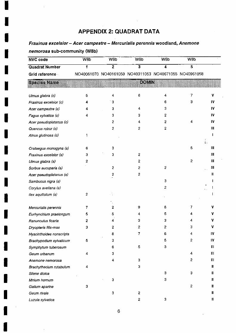
4. COMMUNITY DESCRIPTIONS
A total of 5 quad rats were recorded encompassing 1 communities or sub-communities of
the NVC. Quadrat data is given in Appendix 2.
The following section describes the botanical composition of the communities and how they
compare to the published tables.
• Fraxinus excelsior - Acer campestre - Mercurialis perennis woodland, Anemone
nemorosa sub-community (W8b)
This is woodland of calcareous mull soils with a south-eastern distribution. The Anemone
nemorosa sub-community is characteristic of heavier, increasingly waterlogged soils as are
found in Craighall Den. The canopy constants at Craighall are U/mus glabra, Fraxinus
excelsior, Acer campestre, Fagus sylvatica and Acer pseudoplatanus. Quercus robur is
infrequent and Alnus glutinosa rare. The understory is generally sparsebut Grataegus
monogyna can be locally prominent. Gorylus avellana is local. Mercurialis perennis,
Ranunculus ficaria and Hyacinthoides non-scripta variously dominate the groundflora.
Brachypodium sylvaticum, Symphytum tuberosum, Geum urbanum and Anemone
nemorosa can be frequent. 8ryophytes can be prominent with constant Eurhynchium
praelongum and varying amounts of Brachythecium rutabulum, Thuidium tamariscinum,
Brachythecium rutabulum, Mnium hornum and Atrichum undulatum.
When compared to the published tables for the community, several irregularities occur.
These are most likely the result of management practices including the use of timber from
the wood during the last war and subsequent replanting with exotic species. Gorylus
avellana is less frequent than expected in the understory. In contrast, Acer campestre,
Fagus sylvatica, Acer pseudoplatanus, U/mus glabra and Dryopteris filix-mas are more
frequent than expected. The abundance of U/mus glabra is perhaps the most problematic
as it is usually less common in this sub-community. Brachypodium sylvaticum and
Mercurialis perennis are also slightly more abundant than usual.
Interestingly, Symphytum tuberosum, which can be locally dominant at Craighall, is not
usually found in the community. Geum rivale is similarly not recorded in the tables.
Several characteristic species were not recorded in the quad rats. These include Garpinus
betulus, Rubus fruticosus, Glechoma hederacea, Ajuga reptans, Arum maculatum and
Lonicera periclymenum.
3
I I I I I I I I I I I I I I I I I I I I I

I I I I I I I I I I I I ·1 I I I I I I I I
5. REFERENCES
Cooper, E & MacKintosh, J. 1996 NVC review of Scottish Grassland Surveys. Scottish
Natural Heritage Review No 65.
Corbet, G.B. et al. 1998. The Nature of Fife. Scottish Cultural Press.
Crofts, A & Jefferson, R.G (eds) 1999. The Lowland Grassland Management Handbook.
English Nature/The Wildlife Trusts.
Rodwell, J.S. 1991. British Plant Communities: Vol. 1: Woodlands and scrub. Cambridge
University Press.
Rodwell, J.S. 1991. British Plant Communities: Vol. 2: Mires and Heaths. Cambridge
University Press.
Rodwell, J.S. 1992. British Plant Communities: Vol. 3: Grasslands and Montane
communities. Cambridge University Press.
Rodwell, J.S. 1995. British Plant Communities: Vol. 4: Aquatic communities, swamps arid
tall-herb fens. Cambridge University Press.
Rodwell, J.S. 2000. British Plant Communities: Vol. 5: Maritime communities and vegetation
of open habitats. Cambridge University Press.
.(
'" .
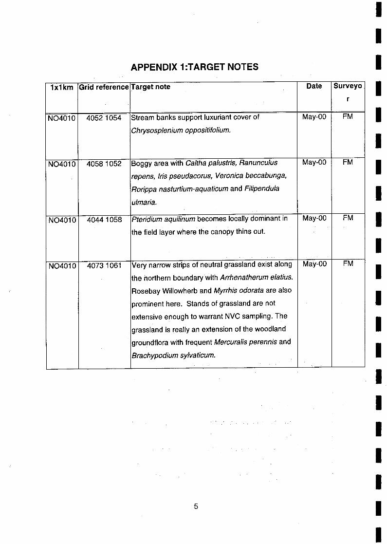
APPENDIX 1:T ARGET NOTES
1x1km Grid reference Target note
N04010 40521054 Stream banks support luxuriant cover of
Chrysosplenium oppositifolium.
N04010 40581052 Boggy area with Caltha palustris, Ranunculus
repens, Iris pseudacorus, Veronica beccabunga,
Rorippa nasturtium-aquaticum and Fi/ipendula
ulmaria.
N04010 40441058 Pteridium aquilinum becomes locally dominant in
the field layer where the canopy thins out.
N04010 40731061 Very narrow strips of neutral grassland exist along
the northern· boundary with Arrhenatherum elatius.
Rosebay Willowherb and Myrrhis odorata are also
prominent here. Stands of grassland are not
extensive enough to warrant NVC sampling. The
grassland is really an extension of the woodland
groundflora with frequent Mercura/is perennis and
Brachypodium sylvaticum.
5
Date
May-OO
May-OO
May-OO
May-OO
Surveyo
r
FM
FM
FM
FM
I I I I I I I I I I I I I I I I I I I I I
I I I
APPENDIX 2: QUADRAT DATA
Fraxinus excelsior - Acer campestre - Mercurialis perennis woodland, Anemone
I nemorosa sub-community (W8b)
NVC code W8b W8b W8b W8b W8b
I Quadrat Number 1 2 3 4 5
Grid reference N040061070 N040161059 N040311053 N040671 055 N040961 058
I U/mus glabra (c) 5 4 6 4 7 V
I Fraxinus exeelsior (c) 4 3 6 3 IV
Acer eampestre (c) 4 3 4 3 IV
I Fagus sy/vatiea (c) 4 3 3 2 IV
Acer pseudoplatanus (c) 2 4 2 4 IV
I Quercus robur (c) 2 2 2 III
Alnus glutinosa (c)
~,
I Grataegus monogyna (5) 6 3 5 III
Fraxinus exeelsior (5) 3 3 2 III
I U/mus glabra (5) 2 2 2 III
Sorbus aucuparia (5) 2 2 2 III
Acer pseudoplatanus (5) 2 2 11
I Sambucus nigra (5) 3
Gorylus avel/ana (5) 2
I /lex aquifolium (5) 2
Mereurialis perennis 7 2 9 8 7 V
I Eurhynchium praelongum 5 5 4 5 4 V
Ranunculus fiearia 2 4 3 3 4 V
I Dryopteris filix-mas 3 2 2 2 3 V
Hyacinthoides nonscripta 8 7 6 4 IV
I Braehypodium sylvaticum 5 3 5 2 IV
Symphytum tuberosum 6 5 3 III
Geum urbanum 4 3 4 III
I Anemone nemorosa 4 3 2 III
Brachythecium rutabulum 4 3 11
I Silene dioica 3 3 11
Mnium hornum 3 3 11
Galium aparine 3 2 11
I Geum rivale 3 2 11
Luzula sylvatiea 2 3 11
I 6
I

Fraxinus excelsior - Acer campestre - Mercurialis perennis woodland, Anemone
nemorosa sub-community (W8b) Cont.
NVC code
Quadrat Number
Grid reference
Primula vulgaris
Thuidium tamariscinum
Dryopteris dilatata
Poa nemoraJis
Poa triviaJis
Hedera helix (g)
Epilobium montanum
Myosotis sylvatica
Urtica dioica
Atrichum undulatum
Crataegus monogyna (g)
Ranunculus auricomus
Veronica chamaedrys
Viola riviniana
Sanicula europaea
Geranium robertianum
Saxifraga granulata
Acer pseudoplatanus (g)
Ribes sanguineum
W8b W8b W8b W8b W8b
1 2 3 4 5
N040061070 N040161059 N040311053 N040671055 N040961 058
2 3
3 2
2
5
4
4
3
3
3
3
3
2
2
2
2
2
7
11
11
11
I I I I I I I I I I I I I I I I I I I I I
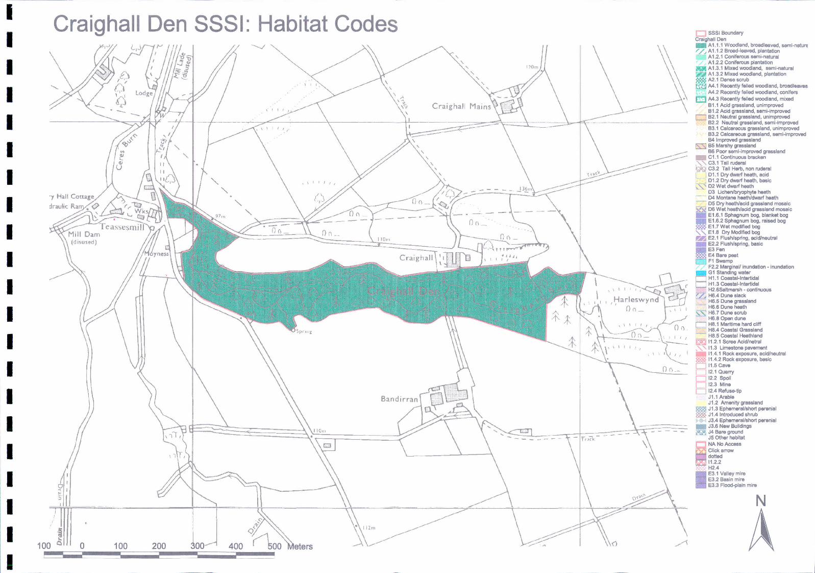
I Craighall Den SSSI: Habitat Codes I
" I " ,
" " , \
" ,. \c~ Craighal l
I -I
\
I I I
.y Hall Co·tul!'e
. - . -
I Of) _'
I Craighall
I I I I I
- --- -- - - - -
I I I ~
100 0 o 100 200 400
I
, , I
Of) I , ,
SSSI Boundary Craighall Den _ A1 .1.1 Woodland, broadleeved, seml·nature r /, A1.1.2 Brood-leaved, plonlation
, - A 1.2.1 Coniferous semi-natural A 1.2.2 Coniferous planiation
g A 1.3.1 Mixed woodland, semi-natural 'n A1.3.2 Mixed woodland, planiatlon ~ A2.1 Danso scrub !:ill M.1 Rocen1ly felled woodland, broadleove8
M.2 Recently felled woodland, conlferti CJ M.3 Rocen1ly felled woodland, mixed
B1.1 Acid grassland, unimproved B 1.2 Acid gmsal!lnd, .emi·improved
D 82.1 Neu1ral g ..... l.nd, unimproved 82.2 Neutral grassland, seml-improved 83.1 Calcareous grassland, unimproved 83.2 Calcareous graaaland, 88mi-improved B4 Improved grassland
IS:Sl 85 Morahy grassland B6 Poor seml-imprcved grassland
_ C1.1 Continuous bracken ., " C3.1 T.II rudaral ',;,lIJ C3.2 Tall Herb, non rudaral r- l DU Dry dwarf heath, acid
. 01.2 Dry dwarf heath, basic ,-,' 02 Wet dwarf hoath
03 Uchanlbrycphyta heath - D4 Manlano haathidwarf heath
05 Dry heathlacld gra&&land mosaic ~ D6 Wet heath/acid grassland m0$8lc _ E 1.6.1 Sphagnum bog, blanket bog _ E 1.6.2 Sphagnum bog, raised bog ~ E1.7Wet modified bog " " E1.S Dry Modified bog I':I!i E2.1 Flushlspnng, aci<1lnou1ral _ E2.2 Flush/spring, basic
~E3Fon
. . E4 Bafe peat F1 Swamp F2.2 MarginaV inundlltion - inundation
_ G 1 S1anding waler
El H1.1 CoaaIaHnlertidal H1.3 Coastal-Intertidal H2.SSaltmarsh - continuous
'7"- HS.4 Dune slack - H6.5 Dune grassland
HS.6 Dune heath
"-'" HS.7 Dune 6CI\lb = -- HS.8 Open dune D HS.1 Mari1imo hard cliff
Ha.4 Coaalal Grassland - Ha.5 Coastal Hoa1hland ~ 11.2.1 Scree AcI<1Inetral _, .... 11.3 Limestone pavement _ 11.4.1 Rock exposure, acldlneutrttl 8881 11.4.2 Rock exposure, b .. lc D 11.5 Cave LJ 12.1 Quarry D 12.2 Spoil C 12.3 Min. D 12.4 Refu .... tip
J1.1 Arablo J 1.2 Amenity grassland
Ill!SlI J1.3 EphemaroVshort peroniol 888f J 1.4 Introduced shrub
.", J3.4 Ephemeral/short parenial _ J3.6 Now Buildings U; J4 Ba", ground
J5 Other habita1 NANoAccas8 Click arrow d_d 11.2.2 H2.4
I E3.1 Valley mire E3.2 Basin mire E3.3 Flood1>lain mire
N

I I I I I I I I I I I I I
I I I I I I
100
Craighall Den SSSI: NVC Codes
-- . --
" ~ ,
1J . <:" ",'
~ <:/
(\00 0 0 100 200 400
\
\
\
\
Craighall
\
\ , \
\
__ .J3~m
•
- - --
I ,I;-Iarleswynd (},,-
. \ I I I, I
c
U 5551 Boundary D Craighall Den 5551
N

I I I I I I I I I I I I I I I I I I I I I
Craighall Den SSSI: Target Notes & Quadrats
! 100 Q
---Teasst::smill Mill Dam (disused)
o 100 200 ~o
I I r. \
\ I I , /_
, -"
, ,
,A {<" Craighall
\
, , , 'l0 111
,
----- ---~-,=-,,...,=---, -'. -'r -----'..---------r.-~~==_~~~~-~~:::::::=:::::::~'\===c====~1\ ~---.:..--,
400
p <'" Q
(\00
, , , ,
_ - - __ . -1J.§..m
~.-- ----
I Harleswynd , , (h,,_ ,\ \ t
o Craighall Den Target Notes Craighall Den Quadrats
o SSSI Boundary D Craighall Den SSSI