snh commissioned report 747: snh's advice on selected
TRANSCRIPT

Scottish Natural Heritage Commissioned Report No. 747
SNH’s advice on selected responses to the 2013 Marine Scotland consultation on Nature Conservation Marine Protected Areas (MPAs)

A D V I C E T O G O V E R N M E N T
Commissioned Report No. 747
SNH’s advice on selected responses to the
2013 Marine Scotland consultation on
Nature Conservation Marine Protected
Areas (MPAs)
For further information on this report please contact:
Ben James or Katie Gillham Scottish Natural Heritage Great Glen House INVERNESS IV3 8NW Telephone: 01463 725000 E-mail: [email protected]
This report should be quoted as:
Scottish Natural Heritage. 2014. SNH’s advice on selected responses to the 2013 Marine Scotland consultation on Nature Conservation Marine Protected Areas (MPAs). Scottish Natural Heritage Commissioned Report No. 747.
This report, or any part of it, should not be reproduced without the permission of Scottish Natural Heritage. This permission will not be withheld unreasonably. This report was commissioned as part of the Scottish MPA Project and the views expressed by the author(s) should not be taken as the views and policies of Scottish Ministers.
© Scottish Natural Heritage 2014.

i
SNH’s advice on selected responses to the 2013 Marine Scotland consultation on Nature Conservation
Marine Protected Areas (MPAs) Commissioned Report No.: 747 Year of publication: 2014 Background
The Scottish Government launched a formal consultation on a suite of possible Nature Conservation MPAs on 25 July 2013, alongside parallel consultations on the draft National Marine Plan, Priority Marine Features (PMFs) and draft sectoral plans for offshore renewable energy. The 16-week consultation period ended on 13 November, 2013. Consultation events and publicity were combined under the banner of ‘Planning Scotland’s Seas’. There were 14,703 responses to the MPA part of the ‘Planning Scotland’s Seas’ consultation. The vast majority of these (14,371) were generated by a series of campaigns relating to seabirds; whales and dolphins, and the development of the MPA network more generally. There were also local community campaigns supporting the designation of the South Arran pMPA and progression of an MPA from the Skye to Mull MPA search location. Marine Scotland officials undertook a preliminary review of the consultation responses and, at the end of December 2013, formally requested that SNH consider the scientific and evidential aspects of 137 discrete responses (59 individuals and 78 organisations) from a total of 332 (216 individuals and 116 organisations). This document sets out SNH’s formal advice in relation to the 17 pMPAs situated entirely (or primarily) within Scottish territorial waters (within 12 nm of the coast). The JNCC is providing separate advice to Marine Scotland regarding the 16 pMPAs in offshore waters (>12 nm). We do not provide any details within this report in relation to the possible progression of the four remaining MPA search locations in territorial waters. These will be the subject of separate formal advice to Scottish Ministers later in 2014. Main findings
We respond to a range of broader and more targeted site-specific issues raised during the consultation. Where relevant, our responses to the broader issues were initially developed in conjunction with our MPA Project partners at the JNCC (i.e. where the broader issues apply across Scotland’s seas). We highlight ongoing work in relation to calls for improved coverage of additional bird and cetacean species within the network. We explain that the network affords protection to far more than 39 species / habitats (as suggested by some respondents) and provide clarity in relation to queries about specific features and the principles used for setting boundaries and conservation objectives. In many cases this reflects our existing advice, supported by clearer explanations of the rationale we used and assessments we undertook. Our commentary is the result of careful consideration of the responses received.
ADVICE TO GOVERNMENT
Summary

ii
A number of the responses sought changes to the boundaries of individual pMPAs, either to encompass additional features or adjacent sea areas. There were numerous calls from two campaigns for an extension to the South Arran pMPA to encompass the entire island. There was also considerable support from local communities regarding possible extensions to the Small Isles pMPA (to incorporate Lochs Scavaig, Slapin and Eishort on the south coast of Skye) and the North-west sea lochs and Summer Isles pMPA (now the Wester Ross pMPA) seeking the inclusion of Loch Gairloch and adjacent maerl beds).
Having reviewed the consultation submissions, SNH does not recommend extensions to the boundaries of any of these pMPAs. The proposed extensions are not required to achieve adequacy within the Scottish MPA network (with the possible exception of native oysters). However, we do recognise the potential nature conservation benefits associated with these requests. We also consider that additional information gathering within the south Skye sea lochs should be undertaken to inform a detailed assessment of the merits of that proposal as part of the first review of the network in 2018.
There were also multiple calls for diverse biogenic habitats such as horse mussel, maerl and seagrass beds to be formally recognised and confirmed as protected features within all pMPAs where they are known to occur. As with the requests for extensions to some pMPAs we believe that there are potentially significant nature conservation merits to adopting a ‘biogenic feature additions’ approach of this type (including potential secondary benefits for some mobile species that may use these seabed habitats). However, we also recognise that additional examples of these features, over and above those already proposed within the pMPAs and covered by existing measures, are not required to achieve adequacy within the Scottish MPA network and we have therefore not recommended any additions.
A small number of respondents commented on the need to include protection for kelp forests within the pMPAs where black guillemots are proposed as a feature. SNH understands that the kelp habitats in the relevant pMPAs will be afforded protection through the conservation objectives as foraging habitat for black guillemot. SNH therefore does not propose adding these habitats as named pMPA protected features.
We provide a short update regarding feature representation within the proposed network i.e. features that are / are not covered in the pMPAs. A number of changes took place between publication of our 2012 MPA network advice and the subsequent 2013 consultation. It was apparent from the responses that we did not make all of these changes sufficiently clear (e.g. at the time of consultation native oysters were only proposed as a protected feature within the Loch Sween pMPA and the inshore deep mud with burrowing heart urchins feature was not recommended within any of the pMPAs).
In response to concerns raised that we had taken a broad-brush approach to boundary setting, we reviewed the boundaries of all of the pMPAs. We recommend changes to the boundaries of seven individual pMPAs. These changes include the exclusion of active harbour areas from the Loch Sunart to the Sound of Jura pMPA (Tobermory Bay, Craignure Bay and the Glensanda Harbour area in Loch Linnhe); modification of the Noss Head pMPA boundary to better reflect the distribution of available horse mussel bed feature records; and the simplification of the outer boundary of the South Arran pMPA (adoption of a minimum convex polygon shape). We identified small landward boundary refinements to three of the pMPAs that support black guillemots as a proposed protected feature (East Caithness Cliffs; Monach Isles; and the Small Isles pMPAs). These changes ensure that only suitable nesting habitat at the back of the shoreline is included within these sites. Collectively these changes reflect the full implementation of the boundary setting principles set out in the Scottish MPA Selection Guidelines. On the basis of new survey work undertaken at the end of March 2014, we also recommend a small extension to the Lochs Duich, Long and Alsh pMPA to fully encompass the flame shell bed feature which is now known to be more extensive than previously thought.

iii
We summarise the findings of an audit undertaken to review the evidence-base behind the South Arran pMPA that was the subject of a number of consultation responses. Insufficient evidence was available to support three individual records of the proposed protected features and these are not considered further in the MPA process (with no effect on the recommended site boundary or case for designation). More generally, our review of the data around South Arran highlighted differences in biotope assignments between different surveys (apparent on completion of analyses of 2013 samples - the provisional results were included in the MPA consulation documents), reflecting heterogeneity in seabed types within the pMPA and the use of expert judgement in the assignment process. In an attempt to more clearly distinguish the distribution and extent of three of the seabed sediment proposed protected features (maerl beds, maerl or coarse shell gravels with burrowing sea cucumbers, and, shallow tide-swept coarse sands with burrowing bivalves); we commissioned an external research project to review the available data for these habitats. We outline the conclusions of that study which recommends refinements to a number of the individual protected feature records and also to the current predicted extents of these habitats.
The external research project confirmed the presence of all three of the protected features around the south of Arran. In accordance with the consultation site assessment documents, the report establishes that live maerl cover is generally very low, rarely exceeding 5%, with beds of living maerl (the proposed protected feature) confined to small pockets off the south coast in areas of low demersal fishing intensity (to the south of Iron Rock Ledges and to the north-east of Pladda). More extensive areas were also identified which, based on current knowledge, appear to offer the most suitable targets for possible conservation management action to support any recovery of the maerl beds feature in this site. With growth rates of the order of 1 mm per year, the recovery of the maerl beds here is likely to take decades.
The provisional results of 2013 marine survey work used in the site-specific consultation documents for three of the pMPAs (Loch Sween, South Arran, and Upper Loch Fyne and Loch Goil) have now been superseded following the completion of all sample analyses and the publication of relevant survey reports (available online from SNH’s commissioned research web pages). Any changes in our understanding of the distribution of the proposed protected features, at these or other pMPAs where new data have become available since the 2013 consultation, will be carried forward into the finalised site assessement documents and evidence-base for the sites.
We propose a series of changes to the draft Management Options Papers prepared for the pMPAs. These include edits to reflect the helpful feedback received during the consultation and ongoing work to refine our data on activities (e.g. in relation to anchorages and aquaculture facilities).
Many of the questions raised in relation to management, including for fisheries, are outwith SNH’s remit. We expect Marine Scotland will consider these when developing management measures for the MPAs that are designated.
Subject to consideration of the conclusions of our analyses, feedback and the proposed refinements to the suite of possible Nature Conservation MPAs, SNH recommends designation of all 17 sites in Scottish territorial waters. SNH will update and finalise all site documents to support potential decisions on designation by Scottish Ministers.
For further information on this project contact: Ben James, CMEU, Scottish Natural Heritage, Great Glen House, Inverness, IV3 8NW
Tel: 01463 725235 or [email protected] For further information on the SNH Research & Technical Support Programme contact:
Knowledge & Information Unit, Scottish Natural Heritage, Great Glen House, Inverness, IV3 8NW. Tel: 01463 725000 or [email protected]

iv
Version control
Version Date Author(s) Reason/Comments
0.1 03/01/2014 Ben James Draft document structure and scope.
0.2 10/03/2014 Ben James and Katie Gillham
Incorporation of joint issues material developed in partnership with JNCC (lead authors from JNCC - Peter Chaniotis, Megan Linwood and Beth Henshall).
0.3 11/03/2014 Owen McGrath Overview of local community responses (s2.1) / opportunities identified (s2.4).
0.4 14/03/2014 Ben James and John Baxter
Incorporation of comments from John Baxter on broad issues text. Addition of material into appendices and preparation of site-specific issues feedback text.
0.5 16/03/2014 Ben James General review, addition of broad issues and continuation of site-specific issues.
0.6 19/03/2014 Ben James, Katie Gillham, Suzanne Henderson and Andy Douse
Review and edits. Preparation and insertion of series of maps showing recommended boundary changes.
0.7 20/03/2014 Ben James, Katie Gillham and David Donnan
Review / edits. New broad issues text and site-specific issues. Pass to SNH principal adviser for QA review.
0.8 21/03/2014 John Baxter QA review.
0.9 21/03/2014 Ben James and Katie Gillham
Address QA comments.
1.0 24/03/2014 Ben James and Katie Gillham
Finalise report and pass to SNH Director for review. Circulate to JNCC colleagues.
2.0 25/03/2014 Ben James and Katie Gillham
Address SNH Director feedback and finalise report for sign-off.
3.0 26/03/2014 Ron Macdonald SNH Director sign-off. Initial submission.
3.1 24/04/2014 Ben James and Katie Gillham
Incorporate 2014 Lochs DLA pMPA survey findings / recommended boundary change.
4.0 29/04/2014 Ron Macdonald SNH Director sign-off. Final version.
Distribution list
Copy Version Issue date Issued to
Electronic 0.7 21/03/2014 John Baxter and Cathy Tilbrook
Electronic 1.0 24/03/2014 Ron Macdonald, SNH Director
Electronic 1.0 24/03/2014 John Davies, Megan Linwood and Peter Chaniotis (JNCC)
Electronic 2.0 25/03/2014 Ron Macdonald, SNH Director
Electronic 3.0 26/03/2014 David Mallon, Sebastian Howell and Michael McLeod (Marine Scotland) [A1153591 / 36(#36)]
Electronic 4.0 29/04/2014 Marine Scotland officials. [A1153591 / 50(#50)]
Electronic 4.0 02/05/2014 SNH web publication. [A1153591 / 50(#50)]

v
Table of Contents Page
1. THE 2013 ‘PLANNING SCOTLAND’S SEAS’ CONSULTATION 1 1.1 The scope of SNH’s input into the analysis of consultation submissions 1
2. CONSULTATION RESPONSES AND SNH FEEDBACK 3 2.1 Community responses 4 2.1.1 Arran 4 2.1.2 Wester Ross 4 2.1.3 South Skye 5 2.2 Broad issues raised 5 2.2.1 MPA network design and the Scottish MPA Selection Guidelines 5 2.2.2 MPA features 13 2.2.3 The evidence-base 25 2.2.4 MPA boundary setting 30 2.2.5 MPA management 32 2.3 Site-specific issues raised 42 2.3.1 Clyde Sea Sill pMPA 42 2.3.2 East Caithness Cliffs pMPA 43 2.3.3 Fetlar to Haroldswick pMPA 44 2.3.4 Loch Creran pMPA 45 2.3.5 Loch Sunart pMPA 46 2.3.6 Loch Sunart to the Sound of Jura pMPA 47 2.3.7 Loch Sween pMPA 50 2.3.8 Lochs Duich, Long and Alsh pMPA 51 2.3.9 Monach Isles pMPA 53 2.3.10 Mousa to Boddam pMPA 54 2.3.11 Noss Head pMPA 55 2.3.12 Papa Westray pMPA 56 2.3.13 Small Isles pMPA 56 2.3.14 South Arran pMPA 60 2.3.15 Upper Loch Fyne and Loch Goil pMPA 67 2.3.16 Wester Ross pMPA (formerly North-west sea lochs and Summer Isles) 69 2.3.17 Wyre and Rousay Sounds pMPA 71 2.4 Opportunities identified 73 2.4.1 Sustaining local economies 73 2.4.2 Benefits to the fishing industry 74 2.4.3 Recreation and tourism 74 2.4.4 Ecosystem services 75 2.4.5 Intrinsic benefits 75
3 SUMMARY AND RECOMMENDATIONS 76 3.1 Overview of proposed changes to the suite of pMPAs 76 3.2 Recommendations and next steps 78
4 REFERENCES 80
5 GLOSSARY 86
ANNEX 1: SUPPORTING THE 2013 ‘PLANNING SCOTLAND’S SEAS’ CONSULTATION - A SUMMARY OF SNH’S ROLE 89
ANNEX 2: LIST OF NATURE CONSERVATION MPA CONSULTATION RESPONSES REVIEWED BY SNH AT THE REQUEST OF MARINE SCOTLAND 91
ANNEX 3: KEY CHANGES TO SNH’S MPA ADVICE ARISING FROM THE 2013 MPA CONSULTATION 94

vi
ANNEX 4: RECOMMENDED POSSIBLE NATURE CONSERVATION MPA BOUNDARY REFINEMENTS 102
ANNEX 5: POSSIBLE NATURE CONSERVATION MARINE PROTECTED AREAS IN SCOTTISH TERRITORIAL WATERS RECOMMENDED FOR DESIGNATION IN 2014 FOLLOWING CONSIDERATION OF SELECTED 2013 MPA CONSULTATION SUBMISSIONS 110 Quick reference list for the ‘Broad Issues’ covered in Section 2.2 Page
MPA network design and the Scottish MPA Selection Guidelines
1. A number of respondents questioned the basis for replication and representation of the MPA search features within the network, proposing that replication infers there should only be two examples of any feature; one that is identified as the representative example, plus a replicate. Queries were also raised about the appropriate scale for consideration of replication and representation within the network, e.g. whether at a Scottish, UK or individual OSPAR Region-level. 5
2. Linked to the consideration of representation and replication, a number of respondents considered that the proposals encompassed too many examples of some features. They were unclear on the additional aspects of Stage 5 of the MPA Selection Guidelines and their role in determining the adequacy of coverage for individual features. 7
3. A number of respondents highlighted that an MPA network that protects only one species of seabird and only 39 species and habitats in total is not ecologically coherent; that such a network would fail the basic tenets of representativity by encompassing less than 1% of the estimated 6,500 species present in Scottish waters. Some respondents noted the inclusion of a small number of representative features but stated that significantly more needed to be done in this regard. 8
4. A number of respondents felt that it was too early to say whether the network as currently proposed would be ecologically coherent. Even with the progression and identification of MPAs from the remaining MPA search locations and completion of parallel marine Natura workstreams, many felt that a more comprehensive assessment would be required before coherence could be stated with any confidence. 9
5. Most people who commented on connectivity recognised its importance in developing a network of MPAs and highlighted the risks of not being able to consider it fully. 11
6. Some respondents commented on the difficulties in assessing connectivity given our current understanding. Specific reference was made to recent work carried out by Marine Scotland Science. There was a range of views expressed from those who doubted whether connectivity had been achieved to others who felt that it was appropriate to approximate connectivity by ensuring that the network was spatially well-distributed. 11
MPA features
7. A number of respondents believed that the list of MPA search features was too restrictive and that the resultant suite of possible MPAs only covers a very narrow range of interests. 13

vii
8. A number of respondents highlighted other marine features that they felt warranted protection within the network (either through listing as MPA search features to drive site identification or through subsequent recognition as protected features of the possible MPAs). 13
9. A number of respondents questioned the potential role of MPAs for Atlantic salmon and sea trout. Respondents also proposed that diverse biogenic habitats such as maerl and seagrass beds (which they felt may offer indirect conservation benefits to migratory fish species and / or their prey) be formally recognised and confirmed as protected features within all of the pMPAs where they are known to occur. 14
10. Some respondents highlighted that work on the MPA network couldn't be considered complete until sites had been identified for the three MPA search features not currently covered at all (e.g. over and above the ones subject to ongoing consideration as part of the remaining four MPA search locations). Respondents also seemed unclear as to whether native oysters were included within the pMPAs. 15
11. A number of respondents believed that the features used to identify MPAs should be confined to the list of threatened and / or declining habitats and species recognised by OSPAR (the ‘T&D’ list). 15
12. A number of respondents appeared uncertain about the relationship between the ‘burrowed mud’ MPA search feature used in the Scottish MPA Project and the OSPAR Threatened and/or Declining (T&D) feature ‘sea-pen and burrowing megafauna communities’. Some questioned whether the physical and biological characteristics of the two features were the same. 16
13. A number of respondents questioned whether the OSPAR T&D ‘sea-pen and burrowing megafauna communities’ feature requires seapens to be present. 17
14. A number of respondents sought clarity on the wider distribution of the burrowed mud feature within pMPAs in territorial waters, querying why the presence of the feature has not been indicated in the site-specific documentation of all pMPAs in which it is found. 18
15. A number of respondents were keen to know which pMPAs in Scottish territorial waters support the OSPAR T&D habitat ‘sea-pen and burrowing megafauna communities’. 19
16. The lack of inclusion of seabirds was noted as a concern in many responses. 19
17. A small number of respondents noted that the black guillemot is neither threatened nor declining and is in fact classified by Birdlife International as of ‘least concern’. 20
18. The lack of inclusion of cetaceans was noted as a concern in many responses. 21
19. It was proposed that MPAs be used as part of a two-tier approach to the spatial protection of seabirds and cetaceans, with Natura sites (SPAs / SACs respectively) identified for internationally important populations and MPAs used to afford protection to a national tier of other important populations. Respondents referred to six seabird colonies already highlighted as meriting MPA designation. 21
20. A number of respondents questioned the classification of the black guillemot as a marine species and also whether the fronts large-scale MPA search feature was a marine habitat. 22

viii
21. Analysis of the consultation responses indicated a divergence of opinion concerning broader ecosystem function and the maintenance of ecological processes as one objective for developing the MPA network. Some respondents thought ecosystem function had not been adequately taken into consideration and others questioned the justification for including some of the large-scale features within the network. 22
22. A number of respondents asked how ecological processes were being considered within the network? 23
23. Some respondents queried the relationship between large-scale features and the species that use such areas, adding to their conservation importance. The respondents asked whether these associated species should also be protected. 24
24. A number of respondents questioned the origins and justification for the addition of ‘representative’ seabed sediment habitats as proposed protected features in some sites. 24
The evidence-base
25. Respondents queried a number of the principles adopted for using evidence in the Scottish MPA Project, for example, suggesting that best available evidence could mean no evidence at all and noting that a reliance on existing data introduces an inherent bias into the site selection process. How were the principles for using the ‘best available evidence’ applied, and how was this evidence generated? 25
26. Some respondents asked whether the evidence used to support the assessment and selection of pMPAs was accessible to everyone. 26
27. A number of respondents questioned what the burrowed mud records shown within the MPA consultation documents actually represented. Were the tall seapen or fireworks anemone points displayed on the maps referring to records of individuals of the species e.g. one seapen? 27
28. A number of respondents questioned the age of the black guillemot survey data, suggesting that for all pMPAs the data are 15 years out of date. The respondents wanted to see this addressed. 27
29. A small number of respondents questioned the transparency in the decision-making process - for example why certain features had been included, the justification for the proposed MPA boundaries, why no alternative locations were proposed in territorial waters etc. 28
30. Was the evidence used subject to independent scrutiny? 29
31. A small number of respondents felt that the peer-review of the underpinning evidence-base and the ‘in-house’ data quality assessments weren’t sufficiently rigorous. 30
MPA boundary setting
32. A range of respondents raised concerns relating to the scale of the pMPAs, suggesting that a ‘broad-brush’ approach had been adopted around areas encompassing often widely distributed features. Some had the perception that the outer limits of the pMPAs were drawn in relation to geographically convenient locations on the map rather than the distribution of proposed protected features. These respondents expressed a preference for the site boundaries to be drawn more tightly around the features - potentially excluding the sea areas in between. How were the boundaries of the pMPAs derived? 30
33. A number of respondents asked whether the outer boundaries to the pMPAs were the same as management boundaries. 32

ix
MPA management
34. A number of the consultation responses raised queries regarding the process used to identify management options for the proposed protected features of the pMPAs, and had particular comments in relation to the management of specific sectors and activities. Respondents also raised queries about the evidence used to inform the management options for different features. 32
35. A number of respondents questioned why management options hadn’t been developed for geodiversity features. 33
36. There were calls for the kelp forests to receive protection within the six pMPAs where black guillemots have been proposed as a protected feature and for these sites to be considered within Scottish Government’s draft seaweed policy statement consultation paper. A number of respondents also recommended that best practice in relation to the use of anti-predator measures around fish farms should be applied within a 5 km radius of black guillemot nest sites as a precautionary approach. 33
37. Some respondents expressed concern that only four of the conservation objectives across the full suite of MPAs have been set to ‘recover’, believing that a more precautionary approach should have been adopted where feature status is currently unknown (in light of declines in condition of the Scottish marine environment as charted in Scotland’s Marine Atlas). 34
38. A number of respondents emphasised the need for a clear understanding of the baseline condition of the MPA features. There was also a view that an improved understanding of activities and compliance with management measures is required. These two aspects were seen as important for enabling an adaptive approach to management of MPAs in the longer-term. 35
39. A small number of respondents challenged that existing fishing activities were having any adverse effect of the marine environment. They highlighted the presence of the features proposed for protection within the MPAs and suggested that their presence confirms the health and high quality of the Scottish marine environment. Some respondents, who accepted that effects were possible, queried whether we had a sufficiently good understanding of the relationship between the state of the features and the intensity of human activities to underpin site management proposals and an adaptive approach to management (in particular, the ability to distinguish anthropogenic effects vs. natural variability etc.). 36
40. Related to the previous issue, some respondents questioned why further management of fishing activity is required if the MPA features are still present. The respondents suggested that fishing pressure had reduced considerably over recent years and that fishing gears have become increasingly more selective, exert less pressure and avoid unwanted by-catch where possible. 37
41. Some respondents argued that some marine habitats rely on a certain level of fishing pressure to maintain populations of key target species. 38
42. Respondents also questioned whether the OSPAR Commission consider MPAs to be a suitable tool for protection of burrowed mud habitats. 38
43. There were questions raised about the overall approach being taken to management including whether ecosystem-based approaches, adaptive management and the precautionary principle were being used and there were also questions about how the sites would continue to support sustainable use. Some questioned how a feature-based approach could achieve these, whilst others felt that the management options were too broad. 38

x
44. Lots of respondents raised issues about the relationship between the MPAs and fisheries, particularly in terms of management and, for example, asking about the relationship with Inshore Fisheries Groups and local management plans. 39
45. There were a number of questions about the process and mechanics of developing management for the pMPAs including: how MPAs would be integrated with marine planning, how management plans would be developed, and the role of stakeholders / marine users. 40
46. A lot of the questions raised in relation to fisheries management are outwith SNH’s and JNCC’s remit and our view is that they are more properly dealt with by Marine Scotland. 40
47. Various comments were made, either in relation to specific pMPAs or more generally on the MPA network, in which people expressed a desire to see more sustainable / less damaging types of fishing gear promoted / used e.g. hand-diving or the use of creels. 41
48. A number of respondents raised concerns over the level of compliance that would be likely to be achieved in relation to management of fishing activity within pMPAs and whether compliance monitoring would be undertaken. 41
Acknowledgements We would like to thank everyone who attended the Planning Scotland’s Seas consultation events last autumn and those who took the time to respond to the MPA part of the consultation. The lead authors wish to thank all those, too numerous to mention by name, who have contributed to the development of this advice, particularly colleagues in JNCC who co-authored feedback on a number of the broad issues raised by the consultation responses. We are grateful to the SNH Scientific Advisory Committee who reviewed the proposed scope and conclusions of the advice as part of the SNH sign-off processes. We also thank Marine Scotland for their support throughout the project.

1
1. THE 2013 ‘PLANNING SCOTLAND’S SEAS’ CONSULTATION
The Scottish Government launched a formal consultation on the proposed Nature Conservation MPAs (shown on Figure 1 overleaf) on 25 July 2013, alongside parallel consultations on the draft National Marine Plan, Priority Marine Features (PMFs) and draft sectoral plans for offshore renewable energy. The 16-week consultation period ended on 13 November, 2013. Consultation events and publicity were combined under the banner of ‘Planning Scotland’s Seas’. Consultation events took place at coastal venues around the country between 19 August and 30 October, 2013. Coordinated by Marine Scotland, the event series included a number of SNH and / or JNCC-led MPA drop-in sessions around the country, offering those from further afield a chance to hear what was being proposed in relation to the Nature Conservation MPAs and ask questions. SNH staff supported 36 of the 56 public events. Marine Scotland produced an overview document to support the consultation which invited respondents to submit their opinions regarding the scientific case for designation; preferred management options; the potential socio-economic impacts; and the likely ecological coherence of the resultant network. Marine Scotland published a Sustainability Appraisal (Strategic Environmental Assessment and Impact Assessments covering the proposed MPA network and individual possible MPAs) plus a Business and Regulatory Impact Assessment (BRIA) for each site. SNH and JNCC prepared a series of site-specific documents for respondents to consider as part of the consultation process. These covered the supporting evidence; application of the Scottish MPA Selection Guidelines (Marine Scotland, 2011a); draft management options; and detailed boundary maps. An illustrated summary glossy leaflet was also produced for each of the pMPAs. All consultation materials remain available on the SNH, JNCC and MS websites. Further details are also provided in Annex 1. 1.1 The scope of SNH’s input into the analysis of consultation submissions
The MPA part of the ‘Planning Scotland’s Seas’ consultation received the largest number of public responses, with 14,703 returns. The vast majority of these (14,371) were generated through 11 campaigns promoted by various organisations. The campaigns related to seabirds; whales and dolphins, and the development of the MPA network more generally. There were also local community campaigns supporting the designation of the South Arran pMPA and progression of an MPA from the Skye to Mull MPA search location. Marine Scotland officials undertook a preliminary review of the consultation responses and, at the end of December 2013, formally requested that SNH consider the scientific and evidential aspects of 137 discrete responses (59 individuals and 78 organisations) from a total of 332 (216 individuals and 116 organisations)1. Analysts (Why Research) engaged by Marine Scotland undertook a detailed review of all of the responses submitted (Marine Scotland, 2014a). The SNH and JNCC reviews of the issues in the relevant responses were undertaken in parallel during January 2014. SNH then assessed the issues and developed this advice during February and March.
1 A similar request was made of JNCC in relation to a smaller (~40+) subset of the responses
focusing on the offshore area and appropriate joint issues (see JNCC, 2014 for details).

2
Figure 1. The full suite of possible Nature Conservation MPAs (pMPAs) and MPA search locations across Scotland’s seas at the time of consultation in autumn 2013.

3
Figure 2 presents a sectoral breakdown of the 137 consultation responses that SNH were asked to consider. The composition of each ‘sector’ is provided in Annex 2.
Figure 2. Sectoral composition of the 137 MPA consultation responses considered by SNH at the request of Marine Scotland.
2. CONSULTATION RESPONSES AND SNH FEEDBACK
This section presents an overview of the consultation responses, the issues raised and SNH’s feedback on relevant scientific and evidential concerns (i.e. those directly linked to the consultation questions). We provide commentary on issues that are within SNH’s remit, primarily focusing on the case for designation. Marine Scotland will provide additional feedback on a number of legislative and policy / interpretive issues, as well as providing an update on MPA management-related questions. A number of the consultation responses discussed the progression of the four remaining MPA search locations. We touch upon this topic briefly under Broad Issue 18 and in Section 3 but do not provide any details within this report. The MPA search locations will be the subject of separate formal advice to Scottish Ministers later in 2014. Local community support was particularly apparent for three of the pMPAs and this is explored in more detail in Section 2.1. Commentary provided in relation to a number of the higher-level / broad issues set out in Section 2.2 was initially developed in partnership with JNCC who have provided separate post-consultation advice to Marine Scotland regarding the offshore pMPAs (JNCC, 2014). The site-specific advice provided in Section 2.3 covers only the 17 pMPAs situated entirely or mainly within Scottish territorial waters. Section 2.4 provides a summary of the perceived wider benefits of the pMPAs identified by respondents. Material changes arising as a result of our consideration of the consultation submissions are collated in Table A3.1 (Annex 3).

4
2.1 Community responses
2.1.1 Arran
Strong support was voiced for the South Arran pMPA by many individuals within the Isle of Arran community. This support was backed by submissions from local organisations including the Community of Arran Seabed Trust (COAST), the Arran Natural History Society and the Arran Trust. Two local campaigns attracted significant interest from outwith the area with a total of 1,315 responses in support of the pMPA (Marine Scotland, 2014a). In responding to the consultation, a number of individuals proposed expanding the boundary of the South Arran pMPA to encompass the whole island, although no particular scientific rationale or evidence was presented in support of this recommendation. Most responses also supported the inclusion of additional protected features, especially seabirds (and the black guillemot in particular). Respondents from the fishing sector and Argyll and Bute Council queried the rationale for including burrowed mud as part of the suite of protected features for the site (see Section 2.3.14 for further details). Those seeking progression of the proposal were largely supportive of firm management measures being applied across the whole site and in particular, sought the exclusion of all bottom-contact dredging and trawling from within the pMPA. COAST presented alternative management options as part of their individual submission and campaign text, and almost all consultation responses from individuals in the community favoured these over management options presented by SNH. The importance of tourism for the island economy was raised in multiple responses with putative links made to economic opportunities associated with the potential future designation of the South Arran MPA. A number of respondents recommended that the conservation objectives for all features within the site be changed from ‘conserve’ to ‘recover’ and referred to the rationale set out within the COAST response by way of justification. 2.1.2 Wester Ross
In May 2012, the Wester Ross community submitted a third-party proposal for an MPA which included both Loch Gairloch and Loch Ewe2 (see SNH & JNCC, 2012a for details). The North-west sea lochs and Summer Isles pMPA boundary (hereinafter referred to as the Wester Ross pMPA3) subsequently recommended by SNH did not include Loch Gairloch and, a number of consultation responses requested that this decision be reviewed. The presence of a range of MPA search feature seabed habitats in Loch Gairloch was highlighted by way of rationale for this re-assessment with seagrass and maerl beds mentioned most often. Many more responses focused on the possible inclusion and / or removal of features from the existing pMPA, reflecting a wide range of opinions. While some requested greater protection of features, others requested that specific features be removed from the pMPA, citing a lack of evidence or proposing that the features be protected elsewhere in the network. A number of responses proposed a change to the name of the pMPA, to the Wester Ross pMPA to better reflect local identity and potentially engender support for the proposal.
2 http://www.wrft.org.uk/files/Gairloch&LochEwe3rdPartyMPABid31MAY19Jun2012forweb.pdf 3 As a result of feedback received during the 2013 MPA consultation we have changed the name of
the North-west sea lochs and Summer Isles pMPA to the Wester Ross pMPA (see Section 2.3.16).

5
2.1.3 South Skye
There were a number of responses from the Skye community supporting an extension of the Small Isles pMPA. Individuals and organisations, including the Skye Fisheries Trust, the John Muir Trust, and the Sleat Community Council, support the inclusion of Lochs Scavaig, Slapin and Eishort on the south coast of Skye within the Small Isles pMPA. A simple justification was provided based on the presence of a number of Biodiversity Action Plan (BAP) habitats including; burrowed mud with seapens, maerl beds, seagrass beds and intertidal under-boulder communities. Additional species, including black-throated divers and seabirds were also included in the rationale. 2.2 Broad issues raised
SNH and JNCC identified a series of higher-level broad issues of relevance to the consultation responses reviewed by both organisations. The feedback provided to many of these issues was initially drafted jointly with JNCC, but only those of most relevance to the pMPAs in Scottish territorial waters are considered here. JNCC’s formal consultation feedback to Marine Scotland covers additional broad and site-specific issues relating to the offshore pMPAs (see JNCC, 2014). Our feedback is presented in a ‘Question and Answer’ format under five themes encompassing: MPA network design, MPA features, the evidence-base, boundary setting, and future management. 2.2.1 MPA network design and the Scottish MPA Selection Guidelines
Application of the MPA Selection Guidelines - Representation and Replication
Broad Issue
A number of respondents questioned the basis for replication and representation of the MPA search features within the network, proposing that replication infers there should only be two examples of any feature; one that is identified as the representative example, plus a replicate. Queries were also raised about the appropriate scale for consideration of replication and representation within the network, e.g. whether at a Scottish, UK or individual OSPAR Region-level.
1
The assessment of replication and representation undertaken by SNH and JNCC followed the Scottish MPA Selection Guidelines (Marine Scotland, 2011a). Correspondingly, our assessment focused on Scotland’s seas and considered the requirements of the Scottish MPA network. More specifically, replication and representation are part of the assessment against the final stage of the Selection Guidelines, i.e. Stage 5. As part of Stage 5, we considered the following alongside each other:
potential areas for MPAs4 (those that passed Stage 4 of the Selection Guidelines);
existing protected areas (e.g. Special Areas of Conservation); and,
other area-based measures considered to make an appropriate contribution to the network (e.g. fisheries closures established for nature conservation purposes).
This enabled us to take into account any contribution already made to the Scottish MPA network by existing measures (the existing protected areas and other area-based measures) when determining which Nature Conservation MPAs and features were required. The Stage 5 assessment is described in more detail under Broad Issue 2. The text below provides notes on how we undertook the assessments of replication and representation. It is difficult to consider these in isolation from the rest of the Stage 5 assessment. Therefore, in
4 This terminology reflects the name given to the areas under consideration at an earlier stage in the
MPA process - full definitions are provided in Section 5 (Glossary).

6
relevant places, the notes below highlight the relationship with assessment of the other parts of the Stage 5 guideline.
Representation
1. This included representing the components of some features within the network, e.g. for burrowed mud it included considering examples of the following four components: fireworks anemones, tall seapens, seapens and burrowing megafauna, and burrowing megafauna and the mud volcano worm.
2. Consideration of representation is linked to the assessment of geographic range and variation, e.g. for offshore subtidal sands and gravels we recommended examples on the continental shelf, the continental slope and in the deep-sea, as well as examples in areas of different water body influence (i.e. Atlantic and Arctic water influence). This is because depth, geographic location and water body influence are key factors known to determine the biological composition of offshore subtidal sands and gravels communities.
3. Our consideration of representation did not involve the formal identification of a specific ‘representative’ example of a feature as proposed by some consultation responses. This approach is not a requirement of either the Scottish MPA Selection Guidelines (Marine Scotland, 2011a) or the OSPAR Guidelines on Developing an Ecologically Coherent Network (OSPAR, 2006). The latter proposes that a network should aim to ‘protect and conserve areas that best represent the range of species, habitats and ecological processes in the OSPAR area’ (see Broad Issue 21 for more details).
Replication
1. The assessment against the replication part of the Stage 5 guideline focused on achieving replication at the scale of Scotland’s seas (i.e. the inclusion of more than one example of a feature within the network). Most features readily met this part of the guideline. The exceptions were features for which there were insufficient data to complete an assessment of more than one site against the Scottish MPA Selection Guidelines, e.g. native oysters.
2. This part of the assessment is allied to a consideration of linkages. For example, previous work by Marine Scotland Science on sandeels highlighted discrete regions on the continental shelf between which there is little exchange of sandeels. One pMPA was recommended in each of these regions. The pMPAs are either in areas considered important for local sandeel production, or they represent source populations considered important for the restocking of sandeel grounds across that particular region. Therefore linkages rather than replication were the determining factor in the number of sites recommended for this feature.
3. This part of the assessment is also linked to a consideration of resilience (mitigating against the risk of losing a feature from the network). Five examples of flame shell beds are recommended for inclusion within the network because of its very restricted distribution (only known within OSPAR Region III5) and because there is evidence of threat and/or decline in Scotland’s seas. Therefore resilience rather than replication was the primary determining factor in the number of sites recommended for flame shell beds.
5 Recent survey work in Orkney [OSPAR Region II] confirmed the presence of individual flame
shells. Follow-up work undertaken in February 2014 recorded no evidence of beds of this species.

7
Application of the Scottish MPA Selection Guidelines - Stage 5 assessment
Broad Issue
Linked to the consideration of representation and replication, a number of respondents considered that the proposals encompassed too many examples of some features. They were unclear on the additional aspects of Stage 5 of the MPA Selection Guidelines and their role in determining the adequacy of coverage for individual features.
2
In Stage 5 of the Scottish MPA Selection Guidelines (Marine Scotland, 2011a), the different potential areas for MPAs (those that passed through the Stage 4 assessment) were considered in terms of the contribution they might make to the MPA network. From a feature perspective, the Stage 5 assessment takes a collective look across the pMPAs and considers whether the inclusion of features is adequate6. The Stage 5 assessment is therefore often referred to as the adequacy assessment. From an area perspective this assessment focuses on how each potential area contributes to the MPA network in Scotland’s seas. The results of the Stage 5 assessments were key to determining how many MPAs were recommended to Scottish Ministers, and also in determining how many examples of individual features were recommended for inclusion within the network in Scotland’s seas. Pages 55 - 57 of the Scottish MPA Selection Guidelines set out the Stage 5 process in detail. In summary, it comprises:
- Representation - Is the feature represented within the Scottish MPA network in the OSPAR regions considered to be important for that feature?
- Replication - Is there more than one example of each feature within the Scottish MPA network? If yes, is there replication across the OSPAR regions in which the feature is recorded?
- Geographic range and variation - Does protection for the feature reflect what is known about its geographic range in Scotland’s seas, e.g. where examples of the feature are found in sea lochs, in areas away from the coast and further offshore? Does protection for the feature reflect the ecological variation of the feature in Scotland’s seas, e.g. examples of the same habitat in different physical conditions with different key and characterising species?
- Linkages - Only assessed where there is a good understanding of the relationship between features in different locations to help build connectivity into the network. For this part of the Stage 5 guideline, the focus has been on areas of importance to the life histories of mobile species.
- Resilience - Is it considered necessary to include a greater proportion of threatened and/or declining features within the network?
The Stage 5 assessment first considered the individual features against the different parts of the guideline to determine how many examples of each feature are required and in what regions. The feature assessments were reviewed against the potential areas for MPAs to see whether there were likely to be either too many or too few examples of each feature within the network. For example, following the Stage 5 assessment we concluded that it was not necessary to include burrowed mud both within the Shiant East Bank MPA search location and the Wester Ross pMPA (formerly the North-west sea lochs and Summer Isles pMPA). This was because both areas supported burrowed mud with tall seapens in an open coast setting within the North Minch. The Wester Ross pMPA also encompassed burrowed mud with tall seapens within sheltered sea lochs. Therefore, between these two areas, we 6 See Section 5 (Glossary) for our definition of this term in this context.

8
only recommended progression of this feature within the Wester Ross pMPA. As part of the Stage 5 assessment a review was also carried out of other features that might be required to add to the broader representativity of the network (see Broad Issues 3 and 24).
Application of the Scottish MPA Selection Guidelines - Broader representativity
Broad Issue
A number of respondents highlighted that an MPA network that protects only one species of seabird and only 39 species and habitats in total is not ecologically coherent; that such a network would fail the basic tenets of representativity by encompassing less than 1% of the estimated 6,500 species present in Scottish waters. Some respondents noted the inclusion of a small number of representative features but stated that significantly more needed to be done in this regard.
3
Commentary regarding the scope of the MPA search features list is provided against Broad Issue 7 (which considers concerns expressed by respondents that the list was not sufficiently comprehensive). One of the starting points for identifying Nature Conservations MPAs was to consider the contribution already being made by existing protected areas and other area-based measures (detailed in Carruthers et al. (2011) and Cunningham et al. (2011) respectively). This step complied with the policy approach of using Nature Conservation MPAs to complement existing measures (Marine Scotland, 2011a). The Special Protection Areas (SPAs) and Sites of Special Scientific Interest (SSSIs) considered to contribute to the network are either estuarine, coastal (covering intertidal habitats upon which the qualifying birds depend) or, in the case of 31 of the SPAs, have been extended into the marine environment. In total, these sites encompass 53 bird species that are dependent on the marine environment, including 22 of the 24 species of seabirds that breed in Scotland (for details see SNH & JNCC, 2012a). Further work is ongoing to identify marine SPAs away from the coast (see Broad Issue 16). The OSPAR Guidance on Developing an Ecologically Coherent Network (OSPAR, 2006) recommends using the EUNIS classification7 Level 3 habitats as a means to representing the range of habitats and species within an MPA network. We assessed the protection of the EUNIS Level 3 seabed habitats within the evolving Scottish network in terms of formally designated features of existing measures and the proposed protected features within the pMPAs / MPA search locations. We concluded that subject to the progression of the pMPAs and the four remaining MPA search locations, all 34 EUNIS Level 3 habitats present in Scottish waters would be protected within each OSPAR region in Scotland’s seas where they are present and replicated across the network where possible to do so. We also concluded that the potential MPA network in Scottish waters would be spatially well distributed (see Section 9 and Appendix 9 of our 2012 network advice for further details). Some respondents recommended that subsequent assessments should also include consideration of the proportion of each EUNIS habitat protected within the network (OSPAR guidance proposes 10 - 20% - see OSPAR, 2006) and the spatial distribution of this protection; such an approach is certainly our intention for future assessments subject to the availability of suitable data.
7 The primary system for characterising the marine environment in European waters - essentially
dividing up the marine area into component habitats that reflect differences in depth, bottom type, exposure etc. and associated communities of species.

9
The 1996 SNH report (Davison, 1996) that derived the estimate of 6,500 higher marine species within Scottish waters (excluding single-celled micro-organisms, viruses and bacteria) specifically excluded seabirds. The vast majority of the species listed (>6,300) are small animals and algae that, in an MPA context, would not be proposed as protected species features in their own right. They represent species typically associated with a wide range of seabed habitats, including those proposed within the Scottish MPA network. The 6,500 estimate includes 2,500 species of crustaceans (crabs, shrimps, barnacles, copepods and fish lice), 1,600 species of worms, 700 molluscs (sea slugs, snails, mussels, cockles and clams etc.), 250 Cnidarians (sea anemones, corals, sea firs and jellyfish) and several hundred species each of fish, sponges, echinoderms and bryozoans amongst others. The site-specific documents produced for each Nature Conservation MPA detail the diversity of species that are encompassed within individual proposed protected features. For example, within the Small Isles Detailed assessment against the MPA Selection Guidelines8 we highlight that survey work in 2010 recorded 194 species associated with a single habitat (circalittoral sand and mud communities) proposed for protection (Howson et al., 2012). This number was based on the collection of seven small sediment samples from the surface of the seabed within the Sound of Canna (each ~0.1 m2). The qualifying habitats of existing protected areas are equally diverse. Remote video sampling undertaken in 2005 within the Firth of Lorn SAC recorded 45 distinct habitats representing the ‘reef’ protected feature (Howson et al., 2006). Each of these discrete habitats supports a diverse associated community of mobile and sessile species in its own right. Whilst it is not possible to quantify the number of species that would be afforded protection within the MPA network with any degree of accuracy, we believe that it would be a significant proportion of the estimated possible 6,500, certainly running to several 1,000s of species. This comprises species that are named as protected features in their own right and those associated with habitats identified as protected features. It is also important to bear in mind that MPAs are not an appropriate mechanism for conserving all forms of marine life in Scotland’s seas (see Broad Issues 7 and 8 on MPA features). Effective action for some species needs to be viewed in the wider context of the Scottish Government’s ‘three-pillar’ approach to marine nature conservation (Marine Scotland, 2012b).
Contribution to an ecologically coherent network
Broad Issue
A number of respondents felt that it was too early to say whether the network as currently proposed would be ecologically coherent. Even with the progression and identification of MPAs from the remaining MPA search locations and completion of parallel marine Natura workstreams, many felt that a more comprehensive assessment would be required before coherence could be stated with any confidence.
4
SNH and JNCC’s assessment followed the Scottish MPA Selection Guidelines and hence Stage 5 focused on the contribution made by the MPA proposals9 to the Scottish MPA network (see Broad Issue 2). In our MPA network advice (SNH & JNCC, 2012a) we also set out our view on the contribution that the resultant network (including SACs and SSSIs etc.) could make to
8 http://www.snh.gov.uk/docs/A987883.pdf 9 We use the term MPA proposal to reflect the time when this work was undertaken (refer to the
glossary for further terms / definitions).

10
developing an ecologically coherent network within the OSPAR maritime area. The text below summarises how we undertook this broader assessment. It should be noted that at present an approach to assess progress has not been agreed at an OSPAR level. Initial assessments by OSPAR have used a simple process that only considers some of the principles where there is sufficient understanding to do so. Therefore the following text briefly outlines the process followed for our provisional assessment in Scotland’s seas (see SNH & JNCC, 2012a for further details). The initial spatial assessment determined whether the network of sites (MPA proposals and other existing measures) was well-distributed across the parts of Scotland’s seas in each of the four OSPAR regions (Regions I, II, III and V). We followed a descriptive approach (i.e. the assessment did not rely on a numerical GIS analysis) that considered the distribution of MPAs in relation to each of the major physiographic features / divisions of the seabed -
- Nearshore (e.g. sea lochs, lagoons, estuaries, coastal island groupings, etc.).
- Continental shelf away from the coast.
- Continental slope.
- Deep-sea environments further offshore (e.g. seamounts, ridges, channels and sediments plains).
We followed the approach recommended by OSPAR for assessing representativity of the MPA network. This involved assessing the representation and replication of broad-scale habitats (see Broad Issue 3) and relevant OSPAR Threatened and/or Declining habitats and species. We concluded that the potential MPA network was spatially well distributed; it encompasses the major physiographic units / divisions of the sea bed within each of the four OSPAR regions (Figure 1) and would provide adequate representation and replication of EUNIS Level 3 broadscale habitats and OSPAR T&D list features. Our conclusions assume that: the recommended pMPAs are designated; that pMPAs are progressed from the remaining MPA search locations; that suitable management is implemented for all sites; and, that other parallel workstreams are completed (e.g. the Natura work programme - see Broad Issues 16 and 18). Full details of the assessment are provided in Sections 9 & 10 and Appendices 8 & 9 of our network advice (SNH & JNCC, 2012a). Further details on wider feature representation within the proposed network are provided against Broad Issues 3 and 24). The process attempted to reflect the aspirations of the three initial spatial tests proposed by OSPAR (OSPAR, 2008a) modified to reflect application at a sub-regional level (i.e. within Scotland’s seas). The OSPAR 2008 guidance noted that whilst initial network assessments were likely to be quite basic, they would become increasingly sophisticated as suitable data become more widely available. This was reflected in their subsequent 2013 assessment of the ecological coherence of the wider network of OSPAR MPAs across the North-east Atlantic (OSPAR, 2013). The 2013 assessment was referred to by some of those responding to the MPA consultation. The key point to note in the OSPAR assessment, that differs from that carried out by SNH and JNCC, was that given the available data, their assessment was not able to consider whether the features were formally recognised as part of the OSPAR MPAs10 used
10 In Scottish waters the OSPAR MPAs are a subset of existing marine SACs and SPAs that meet
one or more of the OSPAR MPA ecological criteria and have been formally recognised by the OSPAR Commission. Further details are available on the JNCC website - http://jncc.defra.gov.uk/page-4526

11
in the analysis. Instead, they examined the spatial overlaps between the OSPAR MPAs and the predicted distribution of EUNIS Level 3 seabed habitats. For the purposes of their assessment, protection was assumed whether or not the habitats were a formal qualifying feature of the sites. Data to undertake a finer resolution assessment at the scale of the North-east Atlantic are not currently available. Whilst some of the conclusions of the 2013 OSPAR MPA network assessment are quite positive, they do not yet reflect the true status of the network in Scottish waters (i.e. the conclusions over-estimate the protection of features). Neither the Scottish nor the OSPAR network assessments have been able to take connectivity or ecological processes fully into account (for more information, see Broad Issues 5 and 6). Through the use of large-scale features such as fronts, wider ecosystem function was considered as part of the SNH and JNCC assessment against the Scottish MPA Selection Guidelines (for further information, see Broad Issues 21, 22 and 23 on ecosystem function / ecological processes in the network). We are aiming to undertake a more sophisticated assessment of coherence at the first review of the Scottish MPA network in 2018. We will update and re-issue our preliminary assessment (see SNH and JNCC’s 2012 MPA network advice report for details) following Ministerial decisions on which Nature Conservation MPAs will be formally designated. This revised assessment will provide a baseline against which further progress by 2018 may be measured.
Further work on the network - Connectivity
Broad Issue
Most people who commented on connectivity recognised its importance in developing a network of MPAs and highlighted the risks of not being able to consider it fully. 5
The OSPAR Commission recognise the importance of connectivity, stating that ‘the MPA network should take into account the linkages between marine ecosystems and the dependence of species and habitats on processes that occur outside the MPA concerned’ (OSPAR, 2003). Connectivity is included within three of the principles set out by OSPAR in their guidance on developing an ecologically coherent network of MPAs (OSPAR, 2006). However, whilst recognised as important, at the scale of the North-east Atlantic aspects of MPA network connectivity are poorly understood (OSPAR, 2013) and Olsen et al. (2013) identified connectivity as a research priority for Europe. In their guidance, OSPAR notes that ‘… a lack of knowledge of connectivity should not prevent the development of the network’. At the Scottish scale, the importance of connectivity is recognised in the Scottish MPA Selection Guidelines (see Broad Issue 6 below for further details). Our view is that connectivity is important in determining whether the Scottish MPA network is ecologically coherent, and also in determining the contribution that we make to the OSPAR MPA network. We recognise that future reviews of the Scottish MPA network will need to take account of new research on the linkages between features as it becomes available.
Further work on the network - Connectivity
Broad Issue
Some respondents commented on the difficulties in assessing connectivity given our current understanding. Specific reference was made to recent work carried out by Marine Scotland Science. There was a range of views expressed from those who doubted whether connectivity had been achieved to others who felt that it was appropriate to approximate connectivity by ensuring that the network was spatially well-distributed.
6
Our assessment of connectivity was essentially undertaken in three stages: firstly during application of the Scottish MPA Selection Guidelines to individual sites and features;

12
secondly through the network assessment as set out in our MPA network advice (SNH & JNCC, 2012a); and thirdly, through incorporation of the results of the modelling work carried out by Marine Scotland Science (Gallego et al., 2013). These are described below. The Scottish MPA Selection Guidelines incorporate connectivity, most notably through the considerations during Stages 1 and 5. Our assessments of connectivity during site selection focused on mobile species and specifically, areas of importance to the life stages of these species where there was a good understanding of this relationship. For example, for sandeels we considered the relationship between a Nature Conservation MPA and the wider marine environment. Based on work undertaken by Marine Scotland Science, discrete areas were identified for localised sandeel production, or because they act as sources of sandeels across the continental shelf. For most benthic species there are insufficient data on their dispersal / reproduction to make a detailed assessment. In our 2012 MPA network advice (SNH & JNCC, 2012a), we included an assessment of the adequacy of feature coverage in the Scottish MPA network. One of the tests used was to look at the spatial distribution of the MPA proposals and existing measures (further details are provided against Broad Issue 4). We included this assessment because it is one of the three tests used by OSPAR to help provide an initial evaluation of whether the OSPAR MPA network is likely to be ecologically coherent. The spatial distribution test is relevant to connectivity on the basis that if sites are not spatially well-distributed then the sites within the network are not likely to be connected (Ardon, 2008). We concluded that the Scottish MPA network would be spatially well-distributed and therefore has the potential to be connected. In 2013, Marine Scotland Science published the results of a bio-physical modelling study that provided an estimate of the extent to which the pMPAs are likely to be linked through the exchange of species larvae, juveniles or adults. They found that connectivity is influenced by the time larvae spend suspended in the sea, known as the pelagic larval phase duration (PLD), which in turn is a critical determinant of how far larvae are transported by prevailing water currents. The season of spawning and distance to shore were also identified as important factors affecting the degree to which areas are connected. A more detailed explanation is provided in the final report of the study (Gallego et al., 2013). On the basis of their modelling work, Marine Scotland Science found that species with a longer PLD (≥ 30 days) that were not solely associated with sea lochs or nearshore areas, could be transported by water movement from the Celtic Sea (OSPAR Region III) to the Greater North Sea (OSPAR Region II) within Scotland’s seas. Species such as the tall seapen and some bivalve molluscs fall into this category. However, the study also found that connectivity may be low in the following circumstances:
For species with a short PLD (e.g. northern feather star aggregations).
For species present in only a small number of MPAs (including Nature Conservation MPAs as well as others such as Special Areas of Conservation).
For species present within MPAs that are close to the shore because these are likely to be less dispersive environments than open waters. This lack of dispersion may be particularly relevant to the west coast sea lochs.
For species present within MPAs in areas that, whilst in more open waters, are still hydrographically isolated. For example, there is a cyclonic eddy that dominates the central parts of the Fladen Grounds. Consequently, the model outputs indicate that self-recruitment of proposed features rather than immigration of recruits from other areas is expected in the pMPAs identified in the Fladen Grounds.

13
The study also recognised that the higher resolution hydrodynamic models currently under development together with greater ecological knowledge should allow us to improve our estimation of connectivity in the future. The first review of the MPA network will take place in 2018 and our intention is to take account of any advances in our understanding of connectivity to review the assessments carried out to date. Should the results of future assessments highlight the need for changes to the Scottish MPA network, we will provide further advice to Scottish Government. 2.2.2 MPA features
MPA features [the legislative background; the MPA search feature list; origins etc.]
Broad Issue
A number of respondents believed that the list of MPA search features was too restrictive and that the resultant suite of possible MPAs only covers a very narrow range of interests. 7
The MPA search feature list was used to guide selection of Nature Conservation MPAs. However, there are already a number of existing protected areas contributing to the Scottish MPA network that largely cover other habitats, species including seabirds and geological features. The features included on the MPA search feature list were not only those that we thought would benefit from the protection that could be afforded by an MPA, but they were also features that we thought would be useful in highlighting locations of wider conservation interest (see also Broad Issue 24). There were a number of reasons why some features weren’t included on the original MPA search feature list. These included one or more of the following:
1. A lack of data on their distribution in Scotland’s seas.
2. For mobile species, a lack of knowledge on essential areas i.e. areas that support key life stages.
3. That the feature was so widely distributed that it would not be useful in helping guide the selection process.
Part of the Stage 5 assessment included a consideration of features that represented the marine environment more broadly and were not adequately included in existing measures (or expected to be included through ongoing work to identify Natura sites for seabirds and marine mammals). Consequently, a number of additional features were identified in territorial waters as proposed protected features of the pMPAs. These features were primarily seabed sediment communities, including an area used historically by spring spawning herring in the Clyde Sea. Broad Issues 3 and 24 provide further information on feature representativity.
MPA features [the legislative background; the MPA search feature list; origins etc.]
Broad Issue
A number of respondents highlighted other marine features that they felt warranted protection within the network (either through listing as MPA search features to drive site identification or through subsequent recognition as protected features of the possible MPAs).
8
Although a number of people responding to the consultation suggested other features that could become protected features of one or more Nature Conservation MPAs, features were only considered if:

14
1. there was sufficient evidence to assess the feature against the Scottish MPA Selection Guidelines (linked to preceding Broad Issue 7);
2. the feature would be likely to benefit from the protection that could be provided by a Nature Conservation MPA; and
3. the feature was not already adequately protected by existing measures.
Our consideration of other additional features proposed by respondents for inclusion within individual MPAs (other than seabirds and marine mammals which are discussed in more detail under Broad Issues 16, 18 and 19, and Atlantic salmon and sea trout which are considered blow) is provided in relevant site-specific sections (see Section 2.3).
MPA features [the legislative background; the MPA search feature list; origins etc.]
Broad Issue
A number of respondents questioned the potential role of MPAs for Atlantic salmon and sea trout. Respondents also proposed that diverse biogenic habitats such as maerl and seagrass beds (which they felt may offer indirect conservation benefits to migratory fish species and / or their prey) be formally recognised and confirmed as protected features within all of the pMPAs where they are known to occur.
9
We do not have sufficient information to define MPAs for Atlantic salmon and sea trout (see Broad Issues 7 and 8). However, these species will be considered under the other pillars (species and wider seas measures) of the Scottish Government’s Nature Conservation Strategy (Marine Scotland, 2011b). For example, the proposal to include these and a number of other finfish and shellfish species as Priority Marine Features (PMFs)11. The PMF list was the subject of a parallel consultation process in 2013. There is currently insufficient evidence to describe marine habitat use by Atlantic salmon and sea trout around Scotland, particularly the relative importance of different places. We have not undertaken a detailed assessment of the presence and distribution of examples of biogenic habitats such as maerl, seagrass and horse mussel beds within the pMPAs where these are not identified as proposed protected features. However, examples of the habitats are known within a number of the pMPAs, including: Wester Ross pMPA (formerly the North-west sea lochs and Summer Isles pMPA), Loch Sween, Small Isles, Loch Sunart, Papa Westray, and Wyre and Rousay Sounds. In many cases the additional features (those not currently proposed for protection) cover small areas of seabed (e.g. seagrass beds within Loch Sunart and the Linne Mhuirich arm of Loch Sween) and some are actually interspersed with the proposed protected features (e.g. seagrass mixed with the maerl proposed feature in Wyre Sound). SNH recognises that there may be potentially significant nature conservation merits to adopting a ‘biogenic feature additions’ approach of this nature (possibly also including secondary benefits for mobile species that use the seabed habitats). However, additional examples of these features are not required to achieve adequate representation within the network (see also Broad Issues 1 and 2).
11 http://www.scotland.gov.uk/Resource/0042/00428389.pdf

15
MPA features [the legislative background; the MPA search feature list; origins etc.]
Broad Issue
Some respondents highlighted that work on the MPA network couldn't be considered complete until sites had been identified for the three MPA search features not currently covered at all (e.g. over and above the ones subject to ongoing consideration as part of the remaining four MPA search locations). Respondents also seemed unclear as to whether native oysters were included within the pMPAs.
10
Although respondents identified three, there are four MPA search features (burrowing sea anemone aggregations, heart cockle aggregations, European spiny lobster, and inshore deep mud with burrowing heart urchins) for which we didn’t identify either possible MPAs or MPA search locations. These features all occur in territorial waters. It was clear during the assessment against the MPA Selection Guidelines that there were insufficient data to justify including these features in any proposed MPA. Inshore deep mud with burrowing heart urchins was a late addition to the list of features for which we did not identify MPAs. Survey work in late 2012 and early 2013 failed to confirm that this feature was present within either of the pMPAs where it was previously thought to occur (i.e. Loch Sween and Lochs Duich, Long and Alsh). If sufficient data become available in future, these features could be reconsidered. However, our view is that it is unlikely that there are aggregations of either burrowing sea anemones or heart cockles and therefore that no further work should be done on these features as part of the Scottish MPA Project. Whilst some respondents highlighted individual records of these species (i.e. not aggregations) that could be included within pMPAs, we do not think this would confer wider conservation benefit to these species or represent an appropriate focus of resources in terms of associated future management, monitoring and assessment. Native oysters are proposed as a protected feature within the Loch Sween pMPA only.
MPA search features and their relationship with the OSPAR T&D list
Broad Issue
A number of respondents believed that the features used to identify MPAs should be confined to the list of threatened and / or declining habitats and species recognised by OSPAR (the ‘T&D’ list). 11
Both the UK Marine and Coastal Access Act (123(3b)) and the Marine (Scotland) Act (79(3)) place a duty on Ministers to develop a network of conservation sites to protect the range of features present in the UK marine area. Within the legislation, the features to be represented within the network are defined broadly as marine species, habitats (or types of habitats) and features of geological or geomorphological interest. The OSPAR Threatened and/or Declining habitats and species list (hereinafter referred to as the OSPAR T&D list) is by definition limited in its composition; it only encompasses biodiversity interests and is defined at the scale of the wider North-east Atlantic. Whilst it therefore covers some habitats and species of relevance to Scotland, it does not cover the full range of habitats and species present in the UK marine area. For this reason, when developing the MPA search feature list (Annex 3 of the Scottish MPA Selection Guidelines - Marine Scotland, 2011a), SNH and JNCC also considered other habitats and species to sit alongside OSPAR T&D features for which MPAs are considered appropriate in Scotland’s seas. SNH and JNCC also identified a comparable list of features of geodiversity importance (Brooks et al., 2013). To be included on these lists, relevant features had to be of conservation importance in Scotland’s seas and be likely to benefit from the kind of spatial protection that could be provided by a Nature Conservation MPA. As

16
part of this consideration, we were looking to identify features that would guide us to places likely to be of wider conservation interest. We felt that this was necessary to ensure that the resulting MPAs would make a significant contribution to the Scottish MPA network, thereby meeting the Scottish MPA Selection Guidelines. This broad focus of the underpinning legislation is clearly reflected in Stage 1 of the Scottish MPA Selection Guidelines:
Stage 1a calls for MPAs to contain features considered to be of conservation value at a national or international level, noting that they are likely to comprise: features for which Scotland is considered a stronghold; features considered to be of exceptional scientific importance; and/or, features that are characteristic of Scotland’s marine environment.
Stage 1b calls for the inclusion of biodiversity features considered to be threatened and/or declining across the North-east Atlantic as described by the OSPAR Commission, as well as MPA search features and geodiversity features which are threatened and/or declining within Scottish waters.
Stage 1c calls for the inclusion of features considered to be critical to the functioning of wider marine ecosystems, such as important feeding, breeding, and spawning or nursery grounds.
Burrowed mud in Scottish waters
Broad Issue
A number of respondents appeared uncertain about the relationship between the ‘burrowed mud’ MPA search feature used in the Scottish MPA Project and the OSPAR Threatened and/or Declining (T&D) feature ‘sea-pen and burrowing megafauna communities’. Some questioned whether the physical and biological characteristics of the two features were the same.
12
The burrowed mud MPA search feature12 comprises the following component habitats and species13 -
Seapens and burrowing megafauna (SS.SMu.CFiMu.SpnMeg14)
Burrowing megafauna and the mud volcano worm Maxmuelleria lankesteri (SS.SMu.CFiMu.MegMax)
Tall seapen Funiculina quadrangularis
Fireworks anemone Pachycerianthus multiplicatus
The feature description and more detailed OSPAR Case Report produced for seapens and burrowing megafauna communities (OSPAR, 2008b & c) specifically associate both component habitats (SS.SMu.CFiMu.SpnMeg and SS.SMu.CFiMu.MegMax codes) and the tall seapen with the OSPAR T&D feature.
12 For more details refer to the MPA search feature descriptions catalogue (Tyler-Walters et al.,
2012) - http://www.scotland.gov.uk/Resource/0041/00413513.doc 13 The mud burrowing amphipod Maera loveni was also included within the original MPA search
feature definition but was dropped as a driver in the MPA selection process due to its short lifespan and ubiquitous, if under-recorded, distribution in burrowed mud habitats in Scottish waters.
14 Scientific reference (biotope) code used to identify different seabed habitats - this provides an important link to the OSPAR T&D feature.

17
The most obvious differences between the Scottish MPA search feature and the OSPAR T&D feature are:
recognition of the fireworks anemone as a specific component species of ‘burrowed mud’ (NB the fireworks anemone is present in fine SS.SMu.CFiMu.SpnMeg mud within both Nature Conservation MPAs where the species is proposed as a feature); and
the inclusion of a deep-water variant of the seapens and burrowing megafauna habitat in OSPAR Region V that includes different characterising seapen species (Kophobelemnon stelliferum and Umbellula encrinus) to those typically found on the continental shelf. This ecological variation is not currently recognised within the OSPAR T&D feature description.
A further less clear-cut distinction is that the burrowed mud MPA search feature also reflects known variation in physical parameters within Scottish waters and therefore includes a wider range of sediment types than simply fine muds. Further information on the burrowed mud feature and how it relates to the OSPAR T&D feature is provided in a number of previous MPA-related reports. These include the MPA search feature descriptions catalogue (Tyler-Walters et al., 2012), a burrowed mud and MPAs ‘position paper’ (SNH & JNCC, 2012b) produced for the 4th national MPA stakeholder event in March 2012, and a summary interpretive guide subsequently issued on the Scottish Government’s MPA web pages15 (SNH & JNCC, 2012c). The definition of the OSPAR T&D feature ‘sea-pens and burrowing megafauna communities’ is the subject of ongoing discussions between Contracting Parties as scientific knowledge improves, particularly for deep-sea areas (relevant to Broad Issue 14).
Burrowed mud in Scottish waters
Broad Issue
A number of respondents questioned whether the OSPAR T&D ‘sea-pen and burrowing megafauna communities’ feature requires seapens to be present.
13
OSPAR (2008b) define the ‘sea-pen and burrowing megafauna communities’ feature as - “Plains of fine mud, at water depths ranging from 15 - 200 m or more, which are heavily bioturbated by burrowing megafauna, with burrows and mounds typically forming a prominent feature of the sediment surface, and which may include conspicuous populations of sea-pens, typically Virgularia mirabilis and Pennatula phosphorea”. The narrative then notes that - “...the tall sea-pen Funiculina quadrangularis may also be present...” At a meeting of the OSPAR Contracting Parties in Bergen in 201116, a key recommendation was that the presence of burrowing megafauna be the essential defining characteristic of the feature and that the presence or absence of seapens does not in itself define the feature.
15 http://www.scotland.gov.uk/Resource/0039/00394205.doc 16 OSPAR meeting in Bergen in October 2011 on the improvement of the definitions of OSPAR T&D
habitats

18
In summary, seapens may form a prominent feature of the seabed surface, but do not have to be present to define the OSPAR T&D habitat (SS.SMu.CFiMu.SpnMeg and/or SS.SMu.CFiMu.MegMax17). This is equally true of the Scottish ‘burrowed mud’ MPA search feature.
Burrowed mud in Scottish waters
Broad Issue
A number of respondents sought clarity on the wider distribution of the burrowed mud feature within pMPAs in territorial waters, querying why the presence of the feature has not been indicated in the site-specific documentation of all pMPAs in which it is found.
14
The burrowed mud MPA search feature occurs in sheltered basins along Scotland’s west coast (including sea lochs), throughout the Minch, in the Moray Firth and Firth of Forth, and in the northern North Sea. Patches of burrowed mud are also present in deep water off the west coast, such as around the St Kilda Basin, along the edge of the Continental Shelf and south of Rockall. A position paper (SNH & JNCC, 2012b) outlining our evolving thinking on representing the burrowed mud MPA search feature within the network was presented to the 4th national MPA stakeholder workshop in March 2012. A short summary guide to the feature, including illustrative distribution maps, was subsequently published on the Marine Scotland website18. Burrowed mud is now a proposed protected feature within six pMPAs in Scottish territorial waters (Loch Sween; Lochs Duich, Long and Alsh; Small Isles; South Arran; Upper Loch Fyne and Loch Goil; Wester Ross). Burrowed mud is also a proposed protected feature within three pMPAs in offshore waters and the Southern Trench MPA search location (see SNH & JNCC, 2012a for full details). These pMPAs / MPA search locations were selected through the application of the MPA Selection Guidelines (Marine Scotland, 2011a) on the basis of the contribution they might make to the MPA network. The pMPAs / MPA search locations provide representation for the four components of the burrowed mud feature (fireworks anemones; tall seapens; seapens and burrowing megafauna; and burrowing megafauna and the mud volcano worm). Further details on representation and replication within the network and the full Stage 5 ‘adequacy’ assessment process are provided against Broad Issues 1 and 2 respectively. The burrowed mud MPA search feature is also known to be present within the following pMPAs in Scottish coastal waters -
- Clyde Sea Sill
- Loch Creran
- Loch Sunart
- Loch Sunart to the Sound of Jura
The burrowed mud search feature within these four pMPAs has not been recommended as a protected feature because it is not required to achieve adequacy within the network.
17 The case report for the OSPAR T&D feature specifically references the SS.SMu.CFiMu.SpnMeg
and SS.SMu.CFiMu.MegMax codes from the National Marine Habitat Classification for UK & Ireland as well as the equivalent codes from the European Nature Information System (EUNIS) classification (A5.361 and A5.362).
18 http://www.scotland.gov.uk/Resource/0039/00394205.doc

19
Therefore, no conservation objective will be set for the feature and no management measures put in place for it within these four sites (see Section 2.2.5). The MPA search feature is either not present, or has not been confirmed, within the other seven pMPAs in Scottish territorial waters (East Caithness Cliffs; Fetlar to Haroldswick; Monach Isles; Mousa to Boddam; Noss Head; Papa Westray; Wyre and Rousay Sounds).
Burrowed mud in Scottish waters
Broad Issue
A number of respondents were keen to know which pMPAs in Scottish territorial waters support the OSPAR T&D habitat ‘sea-pen and burrowing megafauna communities’. 15
One or more of the component habitats and species specifically associated with the OSPAR T&D habitat ‘sea-pen and burrowing megafauna communities’ is present within each of the pMPAs where the Scottish MPA search feature burrowed mud is known to exist and / or has been recommended as a protected feature (see Broad Issue 14 for details). The ‘Burrowing megafauna and the mud volcano worm Maxmuelleria lankesteri’ (SS.SMu.CFiMu.MegMax) habitat predominates in the Loch Sween pMPA. On the basis of available seabed sediment substrate information from the British Geological Survey (BGS) and sampling undertaken by Marine Scotland Science, ‘plains of fine mud’ that might best characterise the OSPAR T&D habitat are known to be present within the Small Isles, and Upper Loch Fyne and Loch Goil pMPAs as well as down the eastern and north-western sections of the South Arran pMPA. Marine Scotland commissioned survey work in 2013 that confirmed the presence of muds within the Loch Sween pMPA, although these were not assigned to specific sediment types (Moore et al., 2013a). Available particle size analysis (PSA) records indicate that the seabed sediments within the Lochs Duich, Long and Alsh, and the Wester Ross pMPAs mainly comprise slightly coarser sandy muds. In terms of the four pMPAs where the burrowed mud MPA search feature is present but hasn’t been recommended as a protected feature of the site; soft muds are known to exist within the Loch Sunart pMPA and may also occur in other parts of the Loch Sunart to the Sound of Jura pMPA (e.g. around Lismore and within Loch Melfort). Similarly, the central basin of Loch Creran pMPA is likely to support mud plains but we do not have readily accessible BGS seabed sediment substrate information to state this with certainty. PSA data are available for relevant areas of the Clyde Sea Sill pMPA and this site is characterised by sandier substrates (i.e. ‘mud plains’ are not considered to be present).
Seabirds in the network
Broad Issue
The lack of inclusion of seabirds was noted as a concern in many responses.
16
SNH within 12 nm and JNCC beyond 12 nm are currently working to provide advice to Scottish Ministers on marine Special Protection Areas (SPAs) under the EC Birds Directive. Marine Scotland is looking at opportunities to disseminate further information on this work programme in 2014 so that regulators, developers and other users of the sea can be made aware of the locations being considered. Should Ministers decide to hold a public consultation as a result of advice from SNH and JNCC then this is likely to be held later in 2014.

20
The marine SPA work is being carried out under the following themes -
Inshore aggregations of non-breeding waterfowl - pursued through the detailed aerial and boat-based survey of specific Areas of Search to allow the identification of the best areas.
Foraging areas for breeding red-throated divers - based on survey and modelling of diver foraging to identify the most suitable feeding areas throughout the coastal range of the species.
Foraging areas for terns at sea - a selection of tern colonies has been extensively surveyed with a view to building generic and colony-specific models of tern distribution at sea allowing prediction of the most important feeding areas around Britain.
Concentration of shags away from their colonies - using the existing European Seabirds at Sea (ESAS) database, inshore aerial survey and site-specific data to identify a suite of the best-known aggregations of shags in Scottish waters.
Seabird Aggregations - Analysis of the European Seabirds at Sea Database (an extensive collection of effort related at sea bird survey data) to identify aggregations of seabirds (31 species of gulls, terns, petrels and shearwaters, gannets, auks and cormorants) occurring from relatively close to shore, to the British Fisheries limit. Analysis covers breeding, moult and wintering seasons (see Kober et al., 2012).
Relevant seabird colonies and colony extensions have already been classified by Scottish Ministers. Current work on marine SPAs is expected to complete the Scottish MPA network for seabirds and marine waterfowl. The only exception to this is black guillemot. This distinctively Scottish species is non-migratory and does not occur on Annex I of the EC Birds Directive so it is not possible to classify SPAs for them. These factors were considered when developing the list of MPA search features. As a result of the assessment against the MPA Selection Guidelines, we recommended six pMPAs for black guillemot. All other species of marine birds are being dealt with by the ongoing work on marine SPAs. See also Broad Issue 19. On the basis of ongoing studies to identify protected areas for seabirds, we have not been able to support any site-specific proposals made in response to the consultation for additions of these interests to the pMPAs. This includes consideration of a small number of proposed boundary refinements to incorporate seabird foraging areas.
Seabirds in the network - Conservation status of black guillemot
Broad Issue
A small number of respondents noted that the black guillemot is neither threatened nor declining and is in fact classified by Birdlife International as of ‘least concern’.
17
The black guillemot is categorised as ‘Least Concern’ under the IUCN global listing, so overall the long-term persistence of this species is considered at present to be guaranteed. In terms of development of the MPA network in Scotland’s seas, there is no requirement for features to be threatened and/or declining for them to be included (see Broad Issue 11). Black guillemot is the only bird species specifically included because it is distinctively Scottish but it is not protected under the EC Birds Directive as a qualifying species of SPAs. Black guillemots in the UK are considered to belong to the Cepphus grylle arcticus sub-species that are found round the coasts of the eastern and western Atlantic. The British and

21
Irish populations make up about 14% of the population of the sub-species, with the majority in Greenland. In the eastern Atlantic, the British population is the largest, followed by the Norwegian population. While the Greenland population may be stable, the British and Irish population is considered stable or declining and there appear to be particular problems in the west and south of Scotland that may be associated with Invasive Non-Native Species (INNS) such as American mink. A regional status assessment therefore lends some weight to the need to take conservation action.
Marine mammals in the network
Broad Issue
The lack of inclusion of cetaceans was noted as a concern in many responses.
18
Section 2.2 of the Scottish MPA Selection Guidelines (Marine Scotland, 2011a) highlights which types of features Nature Conservation MPAs are considered appropriate for and under what circumstances. For mobile species such as marine mammals, Nature Conservation MPAs are only considered where essential areas for key life cycle stages persist over time, including habitats known to be important for reproduction and nursery stages. In developing the list of MPA search features, SNH concluded that for three marine mammal species in territorial waters (white-beaked dolphin, Risso’s dolphin and minke whale) there may be sufficient evidence to support the case for MPAs. SNH is currently refining advice on the progression of three of the remaining MPA search locations in Scottish territorial waters for these cetacean species with a view to providing formal advice to Scottish Ministers in late spring 2014. A fourth MPA search location is still under consideration for seabed features. In offshore waters, JNCC consider there is insufficient evidence available at this time to suggest the presence of areas supporting persistent key life cycle stages or habitats for cetaceans. In both territorial and offshore waters, a range of species measures exist which provide protection to cetaceans in the wider marine environment. Analyses are currently underway to determine whether discrete and persistent areas of relatively high densities of harbour porpoise exist in the UK marine area. Subject to the findings of that work, SNH / JNCC (and the other UK country agencies) may provide advice to Ministers on possible areas to designate as Special Areas of Conservation (SACs).
Seabirds and marine mammals in the network
Broad Issue
It was proposed that MPAs be used as part of a two-tier approach to the spatial protection of seabirds and cetaceans, with Natura sites (SPAs / SACs respectively) identified for internationally important populations and MPAs used to afford protection to a national tier of other important populations. Respondents referred to six seabird colonies already highlighted as meriting MPA designation.
19
Following submission of third-party proposals earlier in the selection process, SNH considered whether it would be appropriate to add cetaceans to any of the pMPAs in territorial waters. The conclusion was that none of them were of an appropriate scale in terms of being able to provide a conservation benefit to such highly mobile species. SNH also considered using MPAs to provide seaward extensions around existing protected areas not already covered by the SPA colony extensions. This work focused on six Sites of

22
Special Scientific Interest (SSSIs) identified as third-party proposals for seabirds. These were the only coastal SSSIs for seabirds in Scotland that were not already covered by SPA extensions. To be consistent with the work on black guillemot, SNH used a 1% population figure as a threshold. This was used because it is an internationally recognised threshold for determining significance in bird populations (NB this is distinct from determining whether a colony is of international importance). For five of the SSSIs, the populations of seabirds did not exceed the 1% threshold and so they were not considered further. The sixth proposal, for gannets at Scare Rocks in Luce Bay, did pass the 1% threshold. However, when this proposal was viewed within the context of existing protected areas for gannets, it was clear that there was no gap in the Scottish MPA network for this species. More than 98% of the breeding population of gannets is already protected in Britain, making it one of the most highly protected species. Therefore our view is that there are no existing protected areas for seabirds in Scotland where it would be appropriate to use MPAs to provide a ‘national tier’ of protection for seabird colony extensions, either because of low population numbers or already high levels of protection within the MPA network.
Classification of MPA features - Black guillemots and fronts
Broad Issue
A number of respondents questioned the classification of the black guillemot as a marine species and also whether the fronts large-scale MPA search feature was a marine habitat. 20
The black guillemot Cepphus grylle is considered a marine species within all definitive inventories including the World Register of Marine Species19 (WoRMS), the Census of Marine Life20 (within the Global Marine Life Database21), and the Marine Species Registers for the Northwest North Atlantic Ocean22. Fronts are a pelagic (open sea) habitat. They form the boundaries between two distinct water masses, for example where tidally mixed coastal waters meet thermally stratified offshore waters, or where fully saline oceanic waters meet lower salinity inshore waters. Pelagic habitats are specifically recognised under the Marine Strategy Framework Directive (MSFD)23. See also Broad Issues 21, 22 and 23, on broader ecosystem function and the maintenance of ecological processes in the network.
Encompassing ecosystem function in the network
Broad Issue
Analysis of the consultation responses indicated a divergence of opinion concerning broader ecosystem function and the maintenance of ecological processes as one objective for developing the MPA network. Some respondents thought ecosystem function had not been adequately taken into consideration and others questioned the justification for including some of the large-scale features within the network.
21
The Scottish MPA Selection Guidelines (Marine Scotland, 2011a) incorporate the concept of function, both in the Guidelines themselves and in the MPA search features. For example, Guideline 1c refers to places that are critical to the functioning of wider marine ecosystems
19 http://www.marinespecies.org/ 20 http://www.coml.org/ 21 http://iobis.org/mapper/ 22 http://webapps.marinebiodiversity.ca/nonNARMS//search.jsp 23 https://www.gov.uk/government/uploads/system/uploads/attachment_data/file/69632/pb13860-
marine-strategy-part1-20121220.pdf

23
and Guideline 2a refers to combinations of features that are functionally linked. In terms of MPA search features, the focus for the mobile species has been on identifying important locations in the life stages of the species. There are also five large-scale features on the list: fronts, the continental slope, shelf banks and mounds, shelf deeps, and seamounts. These large-scale features were included to represent areas of potential wider significance to the health and biological diversity of Scotland’s seas, as a way of incorporating function into the selection of the MPA network. Further information on the large-scale features is provided in a paper produced by SNH and JNCC for the 4th national MPA stakeholder workshop in March 2012 (SNH & JNCC, 2012d). A more detailed position paper will be published later in 2014 but in the interim, the functional role served by these features within relevant pMPAs is explored within the Detailed assessments against the MPA Selection Guidelines. See also Broad Issues 3, 6, 20, 22, 23 and 24.
Ecological processes
Broad Issue
A number of respondents asked how ecological processes were being considered within the network?
22
MPA protected features may include marine species, habitats (or types of habitats) and features of geological or geomorphological interest (see Broad Issue 11). The size and shape of the pMPAs reflect the distribution and extent of their proposed protected features (see Broad Issue 29 and 32) rather than any wider-scale ecological processes. However, both the UK Marine and Coastal Access Act 2009 (s.125-127) and the Marine (Scotland) Act 2010 (s.80; 82 & 83) include provisions to ensure that ecological (and geomorphological) processes upon which the conservation of the protected feature(s) of Nature Conservation MPAs are dependent are maintained. SNH (or Marine Scotland) may give advice and guidance as to the matters that are capable of affecting any ecological or geomorphological process on which the conservation of any protected feature is dependent. Public authorities must not authorise an activity unless they are satisfied that there is no significant risk of the activity compromising the stated conservation objectives for the protected features (see Broad Issue 37). Where appropriate, activities (including those that are unlicensed) occurring within territorial waters (<12 nm) may be subject to the provisions of a Marine Conservation Order (MCO). Marine Scotland will normally be responsible for identifying and implementing any management measures (see Marine Scotland, 2013a for details). The approach taken to maintaining essential ecological processes reflects OSPAR Guidance for developing a network of MPAs across the North-east Atlantic (OSPAR, 2006), which sets out that components of the MPA network “will, individually and collectively, aim to -
protect, conserve and restore species, habitats and ecological processes which are adversely affected as a result of human activities;
prevent degradation of and damage to species, habitats and ecological processes, following the precautionary principle;
protect and conserve areas that best represent the range of species, habitats and ecological processes in the OSPAR area.”
See also Broad Issues 5 and 6 on connectivity.

24
Large-scale MPA search features of ecological significance (ecological function)
Broad Issue
Some respondents queried the relationship between large-scale features and the species that use such areas, adding to their conservation importance. The respondents asked whether these associated species should also be protected. 23
Whilst mobile species such as seabirds and marine mammals may be functionally linked to some large-scale features (e.g. foraging along frontal systems), we believe that protecting the larger interest should secure the ecological services it provides. Such an approach is analogous to protecting reefs within a Special Area of Conservation (SAC) - these serve as a home and foraging areas for a diverse array of different marine organisms but each individual species is not specifically referenced in the site designation order.
Representative features
Broad Issue
A number of respondents questioned the origins and justification for the addition of ‘representative’ seabed sediment habitats as proposed protected features in some sites. 24
MPA search features were used to underpin the identification of the new Nature Conservation MPAs. However, to ensure that the MPA network is also representative of Scotland’s seas more generally, other features may also be formally designated as protected features. As part of the application of Stage 5 of the MPA Selection Guidelines, SNH undertook an assessment to identify other seabed habitats within Scottish territorial waters that should be recognised within the pMPAs to achieve this wider habitat representation. A number of broad sublittoral sediment habitats are only partially covered by the designated / notified features of existing protected areas and the MPA search features (see SNH & JNCC, 2012a for details). In offshore waters these interests are covered by broad MPA search feature categories such as ‘offshore subtidal sands and gravels’ and ‘offshore deep sea muds’. No equivalent MPA search features were identified in Scottish territorial waters (where the broad categories were not considered suitable to drive the initial stages of the site selection process). To best capture the geographic range and ecological variation of these habitats across OSPAR Regions II and III, additional representation was recommended within six pMPAs (Clyde Sea Sill, Fetlar to Haroldswick, Loch Sween, Small Isles, Upper Loch Fyne and Loch Goil, and Wester Ross). A summary assessment and recommendations are outlined in SNH and JNCC’s 2012 MPA network advice and additional information on the features was subsequently provided within relevant site-specific consultation documents (e.g. the Data confidence assessments and Detailed assessments against the MPA Selection Guidelines). Whilst some of the consultation responses noted the inclusion of representative features in this way, it was apparent that the feature names were the cause of some confusion. Originally derived from the component broad sediment groups they represented, this resulted in only four distinctly named features that actually comprised differing finer scale habitats. To provide clarity and aid future differentiation of the six distinct representative seabed sediment features, we recommend small changes to the names of the features within the Clyde Sea Sill pMPA and the Upper Loch Fyne and Loch Goil pMPA (highlighted in blue font below) -
- Clyde Sea Sill pMPA - Circalittoral and offshore sand and coarse sediment communities
- Fetlar to Haroldswick pMPA - Circalittoral sand and coarse sediment communities

25
- Loch Sween pMPA - Sublittoral mud and mixed sediment communities
- Small Isles pMPA - Circalittoral sand and mud communities
- Upper Loch Fyne and Loch Goil pMPA - Sublittoral mud and specific mixed sediment communities
- Wester Ross pMPA (formerly the North-west sea lochs and Summer Isles pMPA) - Circalittoral muddy sand communities
The composition of the features remains exactly the same as at the time of 2013 MPA consultation - only the names have changed. 2.2.3 The evidence-base
Data use principles including ‘best available evidence’
Broad Issue
Respondents queried a number of the principles adopted for using evidence in the Scottish MPA Project, for example, suggesting that best available evidence could mean no evidence at all and noting that a reliance on existing data introduces an inherent bias into the site selection process. How were the principles for using the ‘best available evidence’ applied, and how was this evidence generated?
25
The Scottish MPA Selection Guidelines (Marine Scotland, 2011a) set out that Nature Conservation MPAs would be developed through a scientific process involving stakeholders at key stages. The guidelines noted that a lack of scientific certainty should not be used as a reason for postponing MPA identification. Applying the principle of using the best available evidence constrained the search for MPAs to areas where information already existed, was held by others and could readily be collated and verified, or could be collected within the timescales of the Scottish MPA Project. This ensured a science-led approach without entailing excessive cost. JNCC and SNH recognise that the approach adopted has the potential to introduce a degree of bias into the site selection process (i.e. by highlighting areas subject to more detailed sampling, in some cases possibly undertaken in relation to development proposals). It should also be noted however, that existing information sources, such as the UKSeaMap2010 and more recent EU SeaMap predictive broadscale habitat mapping projects (Cameron & Askew, 2011; McBreen et al., 2011), helped direct data mining and the targeting and prioritisation of new survey effort. Principles guiding the collection and use of evidence to support the selection of pMPAs are outlined in SNH & JNCC (2012a). Building a sound evidence-base involved mining existing data held by SNH, JNCC and other marine science organisations, as well as undertaking new surveys. Application of standard quality assurance processes during data collection and analyses contributed to a robust evidence-base, for example, by using certified laboratories and applying a consistent approach to the internal and external review of commissioned reports. Stakeholder engagement also contributed to data compilation efforts by facilitating data sharing, data verification and identifying opportunities for collaborative research. As outlined in the principles for data use, the level of evidence required to progress MPA search locations to pMPAs varied depending on the nature of the area and the proposed features. For example, lower levels of scientific certainty in the assessment of feature presence, extent and condition, were considered acceptable in areas where there is a lower level of human activities. As a minimum, recent evidence of biodiversity feature presence was required together with a reasonable understanding of feature extent, potentially

26
informed by predictive modelling work in the absence of detailed sampling coverage (e.g. Envision Mapping Ltd., 2014). For each pMPA, JNCC and SNH generated a Data confidence assessment24 document that provides a summary of the evidence-base used and our confidence in it. The assessments consider the following ‘qualities’ of the feature data for each pMPA:
Age of data (when were the data collected?);
Source of data (who collected the data, and what for?);
Sampling methods / resolution (how were the data collected, and what can they tell us - e.g. detailed observations of the seabed by divers or video footage collected by a Remotely Operated Vehicle);
Data coverage (are there data distributed across the whole area, for all of the features?).
Data use principles including ‘best available evidence’
Broad Issue
Some respondents asked whether the evidence used to support the assessment and selection of pMPAs was accessible to everyone.
26
An important principle applied throughout the selection of pMPAs was that the evidence used would be available to others to ensure transparency in the process. Background materials and consultants’ reports have been published routinely (on JNCC or SNH25 web-pages), to show how evidence has been gathered, analysed and applied. JNCC and SNH provided an overview of how we developed the evidence-base to support the identification of Nature Conservation MPAs in Appendix 2 of the 2012 MPA network advice (SNH & JNCC, 2012a). All evidence used to support MPA selection is subject to quality review before being incorporated into the Geodatabase of Marine Features in Scotland (GeMS). GeMS is a live database which is periodically updated when new data become available. An updated version of GeMS, incorporating any changes in our understanding of the distribution of the proposed protected features since the 2013 consultation, will be used to finalise the pMPA site assessement documents in spring 2014. Data from GeMS are made available to view and interrogate via Marine Scotland’s National Marine Planning interactive (NMPi) web portal26. For future iterations of NMPi, we hope to present relevant biodiversity data so that it clearly shows the protected features of the individual Nature Conservation MPAs. Some suppliers provided their data to JNCC and SNH for our exclusive use and existing data access agreements do not permit its onward transmission to third parties without the permission of the data owner. We are currently working with data owners to secure third-party copyright permissions to enable the data within GeMS to be downloadable via relevant online portals in future. Data relating to some species (e.g. native oysters) may be restricted or provided at a reduced geographic resolution.
24 For more details see - http://www.snh.gov.uk/docs/A1034925.pdf 25 http://www.snh.gov.uk/publications-data-and-research/publications/search-the-
catalogue/?q=commissioned%20report 26 http://www.scotland.gov.uk/Topics/marine/seamanagement/nmpihome/nmpi

27
Data qualities - Burrowed mud survey data
Broad Issue
A number of respondents questioned what the burrowed mud records shown within the MPA consultation documents actually represented. Were the tall seapen or fireworks anemone points displayed on the maps referring to records of individuals of the species e.g. one seapen?
27
The burrowed mud records displayed within the site-specific consultation documents (e.g. Detailed assessment against the MPA Selection Guidelines) were collected using a number of different sampling techniques. The vast majority were derived from the analysis of video samples of the sea bed. The video clips may be short ‘drop-down’ recordings or longer ‘towed’ runs, travelling 10s - 100s metres across the sea bed. When reviewing video footage, analysts assign conspicuous species into abundance categories (see Hiscock, 1996 for details). For example, tall seapens or fireworks anemones would be said to be ‘Abundant’ at densities of 1 - 9 / m2 and ‘Frequent’ at densities of 1 - 9 / 100 m2. The scientists who review the video samples record their observations on the range of different species present (with their respective semi-quantitative abundances) and these observations form the foundations for survey reports that are subsequently published (see Broad Issue 26). The number of individual seapens or fireworks anemones recorded on each run will vary but the abundance category gives an indicative guide to the density of particular species in a geographic area at the time of sampling. The video runs could be displayed as lines on a map (each of variable length), using the start and end positions recorded during the survey. However, the records are displayed as singular points within the SNH MPA consultation documents to avoid cluttering the display. Many of the video sequences collected over the last few years have been made available on the Marine Scotland Science YouTube27 pages. Video files from the 2011 collaborative Marine Scotland, SEPA and SNH survey around Canna28 include observations of burrowed mud with tall seapens. For example, tall seapens were considered to be ‘Abundant’ on video run number 6629; and approximately 25 tall seapens are visible during a quick review of the 2¼ minutes of footage. Two of the tall seapens appear to be lying on their side in the mud. The smaller phosphorescent seapen is also present, but in lower numbers. The results of the analysis of all of the video clips from this survey (amongst others) are presented in Moore (2012)30. Within that report the video clip is labelled as sample C66 (see Appendices 1 and 2 therein for full sample details) and on the MSS YouTube pages it is labelled as TV66. Using the Moore (2012) report as a guide it is possible to explore the wide range of different habitats recorded within the Small Isles pMPA during the 2011 survey.
Data qualities - Black guillemot survey data
Broad Issue
A number of respondents questioned the age of the black guillemot survey data, suggesting that for all pMPAs the data are 15 years out of date. The respondents wanted to see this addressed. 28
27 http://www.youtube.com/user/MarineLaboratory/playlists 28 http://www.youtube.com/playlist?list=PL2733211029E58687 29 http://www.youtube.com/watch?v=pnsNgzJnqc4&list=PL2733211029E58687 30 http://www.snh.org.uk/pdfs/publications/commissioned_reports/507.pdf

28
The black guillemot data presented within the site-specific consultation documents were collected as part of the last full nationwide seabird census, Seabird 2000 (Mitchell et al., 2004). Within the six areas now proposed as pMPAs, these data were collected between 1999 and 2002. New survey work to assess the status of the breeding black guillemot populations at four of the pMPAs (Clyde Sea Sill, Fetlar to Haroldswick, Papa Westray, and the Small Isles) was completed in 2013. The provisional results of 2013 sampling were incorporated (but not mapped) within the Detailed assessments against the MPA Selection Guidelines and Data confidence assessments documents for relevant sites. Further details are provided in Swann (2013). The results of the survey work undertaken in 2013 indicate that black guillemot numbers have remained relatively stable in all four pMPAs since Seabird 2000. The variation observed at the different sites between sampling events was considered to be within normal count variability. SNH has commissioned new black guillemot survey work at the East Caithness Cliffs and Monach Isles pMPAs in 2014. Repeat sampling will also be undertaken within the Clyde Sea Sill pMPA (the 2013 work was completed outwith the optimal survey period). The findings of the 2014 work will be published in due course and will inform future discussions on site management (subject to the designation of the pMPAs).
Transparency of decisions
Broad Issue
A small number of respondents questioned the transparency in the decision-making process - for example why certain features had been included, the justification for the proposed MPA boundaries, why no alternative locations were proposed in territorial waters etc.
29
Care was taken by Marine Scotland, JNCC and SNH to involve stakeholders from the beginning of the Scottish MPA Project, and to publish supporting documentation underpinning decisions in the development of the pMPAs, to ensure there was transparency in the decision-making processes. Details relevant to the inclusion of individual protected features are provided in the Detailed assessment against the MPA Selection Guidelines document produced for each pMPA. This document also presents the justification for the outer boundaries of the pMPA (see also Broad Issue 32) and summarises its overall potential contribution to the MPA network. A series of other documents published throughout the course of the Scottish MPA Project provide additional context to the recommended suite of sites consulted upon in 2013. Papers produced for the five national stakeholder workshops31 undertaken in 2011 and 2012 chart the evolution of the project’s evidence-base and explore the original MPA search location options, their boundaries and component features. Options and alternatives exist for the representation of some offshore features within the network, and Marine Scotland sought views on these options during the 2013 consultation. Discussions at the stakeholder workshops and subsequent decisions by SNH meant that in territorial waters the options were narrowed down during the selection process. These decisions were made either because the features were unique (e.g. the fan mussel
31 http://www.scotland.gov.uk/Topics/marine/marine-
environment/mpanetwork/engagement/WorkshopReports

29
aggregation within the Small Isles pMPA) or the combinations of features within a pMPA made a unique contribution to the network (e.g. native oysters, maerl beds, and the burrowed mud component habitat ‘burrowing megafauna and the mud volcano worm’ in the Loch Sween pMPA). Therefore no options were presented within territorial waters during the formal MPA consultation. Position papers presented to the workshops32 outlined the rationale behind the identification of possible MPAs / MPA search locations for specific features (black guillemots, burrowed mud, cetaceans, etc.) and groups of features (e.g. those within sea lochs). Formal commissioned research reports available on the project partner websites present information on the geodiversity features of importance in Scotland’s seas (e.g. Brooks, 2013; Brooks et al., 2013; Gordon et al., 2013). They also present the details of preliminary work undertaken to identify areas considered least damaged / more natural (Chaniotis et al., 2011a - c) and the contribution of existing measures to the network (Carruthers et al., 2011; Cunningham et al., 2011). As well as the data on features, the Management Options Papers produced for each site presented the best available data at the time of consultation on activities occurring within and adjacent to the pMPAs. The need for any management of activities was determined using the Feature Activities Sensitivity Tool33 (FEAST) together with other relevant published reports and guidance (e.g. fisheries management guidance34). Other data were derived from discussions with stakeholders e.g. data on recreational anchorages. For further details on how we developed the management options please see Broad Issue 34.
Independent scrutiny of the designation proposals
Broad Issue
Was the evidence used subject to independent scrutiny?
30
Independent expert review was an important component of the Scottish MPA Project. Stakeholders were given the opportunity to review the evidence used and its application, through a series of five national workshops35 (March 2011 - June 2012) and regular bi-lateral meetings convened by Marine Scotland. Stakeholder views supported a robust assessment against the MPA Selection Guidelines and continue to help strengthen the evidence-base. Both SNH and JNCC have non-executive independent groups within their corporate governance structures comprising specialists drawn from wider academic, NGO, public and private sector communities. These groups provide independent advice and scrutiny to the executive staff of respective organisations. The JNCC MPA Sub-Group and SNH Scientific Advisory Committee reviewed our draft 2012 MPA advice and subsequent 2013 consultation products. These reviews provided an expert examination of the quality of the evidence and the scientific integrity of our gathering, synthesis and interpretation of that evidence. These reviews formed part of the Joint Nature Conservation Committee and the SNH Board (Protected Areas Committee) considerations before they signed-off documents for release to the Scottish Government.
32 http://www.scotland.gov.uk/Topics/marine/marine-environment/mpanetwork/engagement/140312 33 http://www.scotland.gov.uk/Topics/marine/marine-environment/FEAST-Intro 34 http://jncc.defra.gov.uk/page-6498 35 http://www.scotland.gov.uk/Topics/marine/marine-
environment/mpanetwork/engagement/WorkshopReports

30
Independent scrutiny of the designation proposals
Broad Issue
A small number of respondents felt that the peer-review of the underpinning evidence-base and the ‘in-house’ data quality assessments weren’t sufficiently rigorous. 31
Concerns raised during the consultation regarding the qualities of the evidence-base for individual features of the pMPAs are covered in relevant site-specific commentary (see Section 2.3). SNH and JNCC take the view that the Data confidence assessments and Detailed assessments against the MPA Selection Guidelines documents produced for each pMPA present an open and fair appraisal of the status and application of the evidence-base. SNH and JNCC are confident that the non-executive independent expert and stakeholder review processes followed to date (see Broad Issue 30) have been rigorous. Marine Scotland is undertaking an external review of the current evidence-base (from April 2014) that will also take account of any new evidence, new data, new information, or new reflections on existing proposals and evidence, not already contained in original consultation responses. The reviewer(s) will deliver their report on the evidence-base to Marine Scotland in May 2014. JNCC and SNH understand that the reviewer’s conclusions will help inform Scottish Minister’s decisions on the pMPAs. 2.2.4 MPA boundary setting
MPA boundary-setting - a feature-based approach
Broad Issue
A range of respondents raised concerns relating to the scale of the pMPAs, suggesting that a ‘broad-brush’ approach had been adopted around areas encompassing often widely distributed features. Some had the perception that the outer limits of the pMPAs were drawn in relation to geographically convenient locations on the map rather than the distribution of proposed protected features. These respondents expressed a preference for the site boundaries to be drawn more tightly around the features - potentially excluding the sea areas in between. How were the boundaries of the pMPAs derived?
32
The size and shape of the pMPAs reflect the distribution and extent of the range of proposed biodiversity and geodiversity protected features. A site-specific explanation is provided as part of Stage 3 of the Detailed assessment against the MPA Selection Guidelines document provided for each pMPA. The boundary setting principles outlined within Sections 11.9 and 11.10 of the MPA Selection Guidelines (Marine Scotland, 2011a) were subsequently applied to each pMPA that passed the Stage 5 assessment. These principles included -
Drawing the boundaries as closely as possible around the feature(s) to support the MPA acting as a functional whole for the conservation of the features concerned, with consideration given to combining adjacent features into a single MPA.
For mobile species, taking account of places within the natural range of the species that provide the physical or biological factors essential to their life and reproduction.

31
Delineating the footprint of individual protected features and where appropriate combining these into one MPA boundary (in this event, management measures may vary throughout the site depending on the sensitivities of the features present).
The MPA Selection Guidelines propose that the boundary setting principles be put into practice by:
Drawing boundaries away from the coast as straight lines, to ensure ease of identification on charts and at sea.
Using complex site shapes, rather than simple square / rectangular boundaries to ensure that the boundary relates closely to the feature(s) of interest.
Locating co-ordinate points so that they are relevant to the feature of interest, rather than at the nearest whole degree or minute point.
Using ‘mosaic’ sites, in which MPAs may be made up of more than one discrete area where this is appropriate to ensure the boundary closely reflects the distribution of a feature. For example the Mousa to Boddam pMPA comprises two parts proposed primarily to protect sandeels.
In territorial waters, a number of the pMPAs overlap with existing protected areas such as Special Areas of Conservation (SACs) and Special Protection Areas (SPAs). Where appropriate, the boundaries of the pMPAs were aligned with the outer boundaries of these existing measures (e.g. Loch Creran SAC and pMPA) to simplify future management discussions (see also Broad Issue 34). Geographically distinct reference points (e.g. headlands) were adopted to mark the landward edges of a number of the pMPAs in Scottish territorial waters. In accordance with the boundary setting and other general principles set out in the MPA Selection Guidelines (sections 2.5b; 3.2iv; guideline 1c), ecologically functional units such as sea lochs (e.g. Loch Goil) and sounds / bays within natural closing lines (e.g. Wyre and Rousay Sounds) have been included in full where the proposed protected feature(s) are broadly distributed across the pMPAs. In light of comments made regarding the application of a ‘broad-brush’ approach, SNH reviewed the site boundaries of the pMPAs. We identified the need for small refinements to the landward boundaries of three of the pMPAs that support black guillemots as a proposed protected feature (East Caithness Cliffs, Monach Isles, and the Small Isles). These changes ensure that only habitat at the back of the shoreline considered suitable for nesting black guillemots is included within the sites. The post-consultation refinements made to these sites and also to the Noss Head, Loch Sunart to the Sound of Jura, and South Arran pMPAs reflect the full implementation of the boundary setting principles (see relevant site-specific commentary in Section 2.3 for further details). On the basis of new survey work undertaken at the end of March 2014, we also recommend a small extension to the Lochs Duich, Long and Alsh pMPA to fully encompass the flame shell bed feature which is now known to be more extensive than previously thought, extending out from the Kyle Akin Narrows into the Inner Sound (see Section 2.3.8 for further details). A number of respondents proposed changes to the boundaries of the pMPAs that more tighly delineated discrete proposed protected features. In many cases the recommendations reflect the areas that are likely to be subject to management within larger multi-feature sites (see Broad Issue 33).

32
MPA boundary setting and management
Broad Issue
A number of respondents asked whether the outer boundaries to the pMPAs were the same as management boundaries.
33
Management boundaries may differ from the pMPA boundary. Further details on the development of MPA management measures (based on the sensitivities of the protected features) are provided under Broad Issue 34. Where pMPAs encompass multiple widely distributed features, management measures may vary throughout the site. In some instances it may be the case that site boundaries are identical to management boundaries. In other instances, management zones may be implemented within the site boundary relative to the location of sensitive protected features and / or to ensure protection of the range of different types of features within a site. The development of management measures will take account of any supporting ecological processes as well as the protected features themselves. Marine Scotland is leading on the development of management measures for each pMPA. Their consideration of management at a site level will be based on all of the evidence, information and data that are available. The process will require significant input from stakeholders. This is outlined in the MPA Draft Management Handbook (Marine Scotland, 2013a). Marine Scotland recently published draft guidance outlining their ‘Principles for spatial fisheries management boundaries for protected features’ (Marine Scotland, 2014b). Draft fisheries management measures have also been prepared for a number of the pMPAs to support discussions on displacement36.
2.2.5 MPA management
General approach to management
Broad Issue
A number of the consultation responses raised queries regarding the process used to identify management options for the proposed protected features of the pMPAs, and had particular comments in relation to the management of specific sectors and activities. Respondents also raised queries about the evidence used to inform the management options for different features.
34
JNCC and SNH developed Management Options Papers for each of the pMPAs to support early discussions regarding potential management of human activities. These documents were intended to provide stakeholders with information about the background to the options for management that may be considered within each Nature Conservation MPA. Although the formal consultation process has now finished, discussions regarding management options will continue and will focus on the development and implementation of management measures. Marine Scotland is leading the development of the management measures. The approach to identifying management options for each activity was risk-based, i.e. our advice focused on where there was believed to be a risk of the proposed protected features not achieving their conservation objectives (see Broad Issue 37). The Feature Activities Sensitivity Tool37 (FEAST) reflects our current understanding of the sensitivity of features to
36 http://www.scotland.gov.uk/Topics/marine/marine-
environment/mpanetwork/Displacement/Displacement 37 http://www.scotland.gov.uk/Topics/marine/marine-environment/FEAST-Intro

33
pressures associated with marine activities. FEAST was the starting point for developing the management options. In territorial waters, a number of the pMPAs overlap with existing protected areas such as Special Areas of Conservation (SACs) and Special Protection Areas (SPAs). The development of management measures within relevant pMPAs will consider the requirements and conservation objectives of the associated Natura sites (see also Broad Issue 32 re: alignment of outer boundaries of overlapping designations where appropriate to do so). The Management Options Papers consider the range of different activities known to be taking place within or adjacent to the pMPA and ones we knew were being planned. We will update these documents to reflect the helpful feedback received during the consultation and ongoing work to refine our data on activities (e.g. in relation to anchorages and aquaculture facilities). Introducing consideration of all possible future activities or eventualities was not the purpose of these documents.
General approach to management - Geodiversity features
Broad Issue
A number of respondents questioned why management options hadn’t been developed for geodiversity features.
35
In accordance with the approach used for biodiversity features, the management options for proposed protected geodiversity features are based on what is known about their sensitivity to pressures (Brooks, 2013). Information on the sensitivity of geodiversity features has been incorporated into the Feature Activities Sensitivity Tool (FEAST). The sensitivity of geodiversity features was considered in the Management Options Papers for offshore pMPAs at the time of consultation and will be incorporated into the finalised documents for pMPAs in territorial waters (see also Table A3.1, Annex 3). In offshore waters, all of the geodiversity features that were considered sensitive to pressures associated with activities within the pMPA also overlapped with a biodiversity feature. The management options presented for the overlapping biodiversity features are considered appropriate for achieving the conservation objectives of the geodiversity features. This is highlighted in the Management Options Papers for the relevant pMPAs.
General approach to management - Black guillemots
Broad Issue
There were calls for the kelp forests to receive protection within the six pMPAs where black guillemots have been proposed as a protected feature and for these sites to be considered within Scottish Government’s draft seaweed policy statement consultation paper. A number of respondents also recommended that best practice in relation to the use of anti-predator measures around fish farms should be applied within a 5 km radius of black guillemot nest sites as a precautionary approach.
36
There is no doubt that black guillemot are dependent to a very large extent on sublittoral stands of kelp (Laminaria spp.) as this habitat supports a range of prey species (small fish and invertebrates) that are not present in other habitats. SNH understands that the kelp habitats in the relevant pMPAs will be afforded protection through the conservation objectives (see Broad Issue 37), as foraging habitat for the black

34
guillemots. SNH therefore does not propose the addition of these habitats as named protected features within the pMPAs. Management to ensure that habitat maintains its structure and functional attributes of relevance to black guillemot foraging activity will be a key element of any site management prescriptions (and relevant in the context of the draft seaweed policy statement consultation paper38 that sought views on the regulation of seaweed harvesting). SNH routinely advises that aquaculture farms require a predator management strategy to be in place prior to development and that all cage and predator nets should be correctly tensioned and well maintained. On the basis of 2013 tagging work undertaken as part of the RSPB’s Future of the Atlantic Marine Environment (FAME) project there is now clear evidence that black guillemots can travel further afield than the waters adjacent to their breeding colony to forage, generally into nearby shallow inshore areas with kelp forests. The furthest distance recorded was just over 7 km from the breeding colony (although the majority of the birds forage well short of this maximum distance). The analysis is ongoing but preliminary conclusions are that these longer movements are more likely when black guillemot colonies occur within an archipelago of islands (e.g. within the Papa Westray, and Fetlar to Haroldswick pMPAs), rather than along mainland coastlines or isolated islands (as at the East Caithness Cliffs, Small Isles, Monach Isles, and Clyde Sea Sill pMPAs). These findings do not affect SNH’s original recommendations regarding a 2 km seaward boundary definition for black guillemot to encompass the majority of feeding birds that forage along the coastine adjacent to the breeding coast. Without further bespoke survey work at each colony, there is currently insufficient evidence to extend the distance beyond this, given that longer foraging distances are almost certainly site-specific.
Conservation objectives
Broad Issue
Some respondents expressed concern that only four of the conservation objectives across the full suite of MPAs have been set to ‘recover’, believing that a more precautionary approach should have been adopted where feature status is currently unknown (in light of declines in condition of the Scottish marine environment as charted in Scotland’s Marine Atlas).
37
Conservation objectives (COs) are set for each protected feature within each pMPA. The COs reflect what we want to achieve for the protected feature of a Nature Conservation MPA. The broad purpose of designating a Nature Conservation MPA as set out in the Marine Acts39 is to ‘conserve’ its features. Consequently, Marine Scotland’s policy is that the default conservation objective is to ‘conserve’. The COs are set using best available evidence. Although our confidence in the presence of proposed protected features is generally good, our confidence in the quality of these features is often less so. When the condition of a proposed protected feature is not known, its CO has been set to ‘conserve (feature condition uncertain)’. The conservation objectives for the 139 proposed protected features reflect this position, 82 have the conservation objective ‘conserve (feature condition uncertain)’, 53 ‘conserve’ and 4 are set to ‘recover’.
38 http://www.scotland.gov.uk/Publications/2013/08/6786 39 Section 117(1) of the Marine and Coastal Access Act, 2009 and Section 68(1) of the Marine
(Scotland) Act, 2010.

35
A ‘conserve’ or ‘conserve (feature condition uncertain)’ CO does not mean that management will not be required to ensure that the feature achieves this objective. Management requirements are identified on the basis of the sensitivity of features to pressures associated with activities taking place within or adjacent to each pMPA (see Broad Issue 34). For features that are considered to be at greater risk, a higher level of management may be required. The COs do not reflect the status of the wider population of a feature or the condition of a habitat more broadly across Scotland’s seas. It’s perhaps not surprising therefore that many of the COs are ‘conserve’ or ‘conserve (feature condition uncertain)’ because on the whole we have tried to identify good examples of the MPA search features. Information on the approach to setting conservation objectives in the Scottish MPA Project is provided in the Draft Nature Conservation MPA Management Handbook (Marine Scotland, 2013a).
The management evidence-base - Monitoring feature condition
Broad Issue
A number of respondents emphasised the need for a clear understanding of the baseline condition of the MPA features. There was also a view that an improved understanding of activities and compliance with management measures is required. These two aspects were seen as important for enabling an adaptive approach to management of MPAs in the longer-term.
38
Our current knowledge of the presence, extent and condition of features within each pMPA is detailed in the Data confidence assessments. A programme of marine survey work will continue to fill gaps in our knowledge base. Such survey over the first 6 yearly review cycle (to 2018) will also consider feature-specific needs, including studies to improve our understanding of the relationships between feature condition and differing levels of anthropogenic pressure, for example for burrowed mud (and a number of other seabed sediment habitats) where management options to ‘reduce or limit’ such pressures have been proposed. At the same time, options for integrated monitoring of marine biodiversity, including within MPAs, are being developed as outlined below. JNCC, with SNH and other partners, is currently leading a research and development programme to develop an integrated system of monitoring for marine biodiversity across all UK waters. The programme aims to provide a framework for biodiversity monitoring to meet obligations under the Marine Strategy Framework Directive, Habitats and Birds Directives and the OSPAR Convention. The Programme is preparing monitoring options advice for Governments, and monitoring and assessment of MPAs, including Nature Conservation MPAs, is an integral part of this programme. Monitoring options under development for MPAs, building on monitoring already carried out for Natura 2000 sites, include:
identification of a set of measurable characteristics, attributes or indicators that describe the condition of the feature either directly or indirectly, including elements which relate to habitat extent, structure, function, and associated species, and pressures which may affect feature condition;
setting of broad targets or target ranges for each of these attributes which will better enable us to assess whether the feature is in good condition; and

36
identification of appropriate sampling methods and levels of sampling required to provide the statistical power necessary to detect change, and the development of a programme of surveys to assess the condition of features within sites.
Monitoring within Nature Conservation MPAs in Scottish waters will aim to:
enable assessment of the condition of the features within sites;
enable assessment of the degree to which management measures are effective in achieving the conservation objectives for the protected features;
support the identification of priorities for future protection and/or management; and
enable Government to fulfil its national and international assessment and reporting commitments in relation to protected areas and help identify where further action may be required.
Marine Scotland is leading the development of management measures within the pMPAs (see Broad Issue 34). SNH understands that Marine Scotland will subsequently monitor future compliance with the prescriptions set, and track changes in relevant activity levels within the sites. This information will be shared with those bodies tasked with undertaking the biodiversity monitoring to place observations into context and enable adaptation of management where appropriate.
The management evidence-base - Evidence of human impacts
Broad Issue
A small number of respondents challenged that existing fishing activities were having any adverse effect of the marine environment. They highlighted the presence of the features proposed for protection within the MPAs and suggested that their presence confirms the health and high quality of the Scottish marine environment. Some respondents, who accepted that effects were possible, queried whether we had a sufficiently good understanding of the relationship between the state of the features and the intensity of human activities to underpin site management proposals and an adaptive approach to management (in particular, the ability to distinguish anthropogenic effects vs. natural variability etc.).
39
Human activities exert a number of pressures on the marine environment, and as an island nation we will continue to seek food, energy and recreational opportunities from our waters. Scotland’s Marine Atlas (Baxter et al., 2011) presents the most recent comprehensive assessment of the status of our seas. This draws upon a substantial evidence-base (e.g. OSPAR, 2010) that points to the pressures and impacts on the marine environment from fishing - including damage or loss of habitats, impacts on target and non-target species and indirect impacts on community structure and food webs. Taking one example of a proposed protected feature, maerl beds, a review of relevant studies (Hall-Spencer et al., 2003) points to bivalve fisheries as one of the key threats to this feature across Europe, resulting in reduced biodiversity, structural complexity and long-term habitat degradation. The management options proposed in relation to this feature (within relevant pMPAs) are intended to prevent detioriation in the quality of the maerl habitats present. There are specific examples from Scotland that reflect the general concern for habitat degradation related to fising activities. Moore et al. (2013b) document a relatively recent decline in the condition of the flame shell beds feature within the Upper Loch Fyne and Loch Goil pMPA. This resulted in a recover objective being set for this feature in this location (see Broad Issue 37). Whilst we have an improving knowledge-base we do not have a detailed understanding of the previous extent and distribution of many seabed habitats in Scottish waters because extensive and routine sampling really only began in the 1980s.

37
There have been some exciting new discoveries since the start of the Scottish MPA Project in 2010 including the largest known bed of giant fan mussels in the UK in the Sound of Canna, possibly the largest known bed of flame shells in the world in Loch Alsh, and the largest horse mussel bed in the UK off Noss Head. However, it is likely that these features were once more widespread and an analysis of human activities around the margins of these features suggests that ongoing activities may in fact be constraining their extent in some locations. We recognise that the intensity of human activity and pressures on marine features varies considerably across Scottish waters. It may be that features within different MPAs respond differently to management for a number of reasons, including prevailing environmental conditions and current and historical uses of the site. Future pMPA management will therefore need to be flexible and adaptive to accommodate local circumstances and will need to be supported by an effective monitoring and surveillance programme (see also Broad Issues 34, 43 and 44). With additional pressures such as climate change now starting to be felt in the marine environment, it is essential that we take steps to manage our precious marine resource more effectively for the longer-term benefit of all the people of Scotland. One of the immediate concerns related to climate change is the likelihood that it will exacerbate impacts from other activities. This underlines the importance of careful management of relevant activities in MPAs as a contribution to improving the resilience of habitats and species to climate change. Nature Conservation MPAs are one piece of the jigsaw and they will function within a broader marine planning and management framework (see Marine Scotland, 2013a for further details). We are not seeking to return Scottish waters to any form of pre-industrial panacea, but rather to ensure that management of MPAs helps build resilience into our marine ecosystems and contributes to the wider health of Scotland’s seas. The evidence-base used to develop management options for the proposed protected features is detailed in FEAST (Marine Scotland, 2013b). Worldwide, there is a substantial body of peer-reviewed published evidence that documents the potential effects of various fishing practices on the sea bed and its associated communities. In addition to FEAST, relevant evidence sources have also informed the development of the Fisheries Management Guidance40 documents produced by SNH and JNCC.
MPAs and the relationship with fisheries management
Broad Issue
Related to the previous issue, some respondents questioned why further management of fishing activity is required if the MPA features are still present. The respondents suggested that fishing pressure had reduced considerably over recent years and that fishing gears have become increasingly more selective, exert less pressure and avoid unwanted by-catch where possible.
40
We acknowledge the efforts of the fishing industry to fish in a sustainable manner and the efforts they have made regarding gear selectivity / by-catch reduction. However, these are primarily fishery management measures and may not always contribute to the conservation objectives of the MPA features. Within some pMPAs a conclusion may be reached that no additional management is required. In others, measures may be put in place to either reduce current effort or to avoid effort increasing again in future i.e. application of the ‘reduce / limit’ management option. However, in some cases, particularly where there are highly sensitive features, our only advice can be to ‘remove / avoid’ relevant activities.
40 http://jncc.defra.gov.uk/page-6498

38
MPAs and the relationship with fisheries management
Broad Issue
Some respondents argued that some marine habitats rely on a certain level of fishing pressure to maintain populations of key target species.
41
It may indeed be the case that in some fisheries, the fishing method helps to maintain or favour the target species population. The reasons for this can be variable and may be because the seabed is modified to make the gear more efficient for the target species (compared to an unfished seabed), or it may be due to some biological factor that favours the target species. However, it is the conservation of seabed habitats and their associated communities of animals and plants that is the objective of MPA designation. We know from abundant peer-reviewed research that the general impact of fishing is a reduction of habitat complexity, change in infaunal and epifaunal community structure, long-term changes in vulnerable species, and reallocation of energy in the system. So, regardless of whether or not fishing supports or maintains the populations of target species, we know that this is at the expense of wider diversity of species that will have existed on the unfished / undisturbed habitat. Therefore, the point about fishing pressure maintaining the target population can only be valid where an MPA’s conservation objective for the proposed protected feature(s) is the same as the fishery objective.
MPAs and the relationship with fisheries management
Broad Issue
Respondents also questioned whether the OSPAR Commission consider MPAs to be a suitable tool for protection of burrowed mud habitats.
42
OSPAR Recommendation 2010/1141 calls for Contracting Parties to consider the introduction of national legislation to protect OSPAR T&D habitat ‘sea-pen and burrowing megafauna communities’ (see also Broad Issues 12, 13, 14 and 15) and to consider whether any sites within its jurisdiction justify selection as MPAs for the conservation and recovery of this T&D feature. The same OSPAR recommendation calls for Contracting Parties to draw relevant issues, such as requests for closing areas to fishing where there may be a significant adverse impact on sea-pen and burrowing megafauna communities from fishing, to the attention of fisheries management authorities - in accordance with Annex V of the OSPAR Convention.
MPAs and the relationship with fisheries management
Broad Issue
There were questions raised about the overall approach being taken to management including whether ecosystem-based approaches, adaptive management and the precautionary principle were being used and there were also questions about how the sites would continue to support sustainable use. Some questioned how a feature-based approach could achieve these, whilst others felt that the management options were too broad.
43
All of our work on Nature Conservation MPAs is set within a wider ecosystem-based approach to management. Marine Scotland’s three-pillar approach to marine nature 41 OSPAR Recommendation 2010/11 on furthering the protection and restoration of sea-pen and
burrowing megafauna communities in the OSPAR Maritime Area (OSPAR 10/23/1 - E, Annex 33).

39
conservation sets protected areas within a broader context of site protection, species protection and wider seas policies and measures. At the scale of the MPA network, we consider the relationships between the different sites within the network and with the wider marine environment. At the scale of individual MPAs, an ecosystem-based approach leads us to consider, for example, the ecological relationships between features within an MPA including any supporting ecological processes. All of which informs our advice on the management of MPAs. We view adaptive management as a part of an ecosystem-based approach and a key part of taking forward management of MPAs. We are keen that there is a clear feedback mechanism that enables us to assess the success of any management measures in terms of whether or not the conservation objectives are being achieved. These assessments will be based on the results of monitoring the condition of the protected features and also through improved information on relevant activities (see Broad Issue 38). The availability of robust evidence will be essential for underpinning future reviews of site management. The precautionary principle is also incorporated within our overall approach to management. For example, SNH’s management options were developed using a risk-based approach i.e. using an understanding of the sensitivities of the proposed protected features and the known or likely locations of relevant activities. This avoids the need for us to wait until there is evidence of damage to protected features before management measures can be put in place. We also accept that at present we may not know all the answers in terms of how best to achieve the conservation objectives across the full range of protected features in the different Nature Conservation MPAs. Therefore, alongside our advice on management options, and Marine Scotland’s developing work on management measures, we are also working to develop collaborative research projects that will enable decisions to be better informed in future. For example, see Section 2.3.6 for proposed studies relating to common skate within the Loch Sunart to Sound of Jura pMPA.
MPAs and the relationship with fisheries management
Broad Issue
Lots of respondents raised issues about the relationship between the MPAs and fisheries, particularly in terms of management and, for example, asking about the relationship with Inshore Fisheries Groups and local management plans. 44
Whilst the focus of Nature Conservation MPAs is on the conservation of the protected features, we acknowledge that the sites (and features within them) may be able to make a contribution to the sustainability of certain fisheries. However, this contribution needs to be viewed within the context of the fishery as a whole. It also needs to be viewed at the scale at which the fishery operates. Where Inshore Fisheries Groups (IFGs) exist, we would like to see the IFGs as the logical place within which the discussions on fishery management relating to Nature Conservation Marine Protected Areas take place. We continue to be strong advocates of the value of management plans for inshore fisheries (especially with respect to the IFGs) as a way to encourage a long-term, proactive and ecosystem-based approach. Any agreed measures or actions arising in relation to Nature Conservation MPAs would / could be reflected in the relevant IFG management plan(s). We see the IFG management plans (in future fully integrated into regional marine plans) as the key tool for coordinating fishery management with management of other activities / uses of the marine environment. The quality of any plans will be highly dependent on the quality of the information that is fed into it. SNH strongly supports efforts to improve understanding of fishing activity and to obtain better information (e.g. such as ScotMap or in the way that the Shetland Shellfish

40
Management Organisation have improved data collection which has subsequently been used to inform management). This also relates to the use of remote vessel monitoring technologies, which SNH supports, to improve understanding of fishing activity and support good decision-making.
MPAs and the relationship with fisheries management
Broad Issue
There were a number of questions about the process and mechanics of developing management for the pMPAs including: how MPAs would be integrated with marine planning, how management plans would be developed, and the role of stakeholders / marine users.
45
Throughout the Scottish MPA Project, Marine Scotland, SNH and JNCC have engaged with representatives of the fishing industry and, through a series of local meetings, directly with the industry. SNH and JNCC will continue to support Marine Scotland in discussions with the industry over the development and implementation of fisheries management measures for Nature Conservation MPAs. The Management Options Papers produced by SNH and JNCC were intended as a starting point for discussions over how pMPAs should be managed. Marine Scotland is responsible for developing management measures, in discussion with stakeholders, to ensure the conservation objectives are met. Marine Scotland has also stated that they intend to establish a management plan for each Nature Conservation MPA (Marine Scotland, 2013a). By clearly setting out the requirements of the individual MPAs, these plans will help ensure that the management of these sites can be better integrated with other existing and future plans, for example, with IFG management plans and other local / regional initiatives of relevance to fisheries (such as Clyde 2020). Comments were made on the detail of the management options relating to fisheries for a number of the possible MPAs. These are covered in Section 2.3. There were also comments on the management measures that should be put in place. As mentioned above, Marine Scotland is responsible for developing and putting in place management measures to achieve the conservation objectives and they will consider these comments when developing management measures.
MPAs and the relationship with fisheries management
Broad Issue
A lot of the questions raised in relation to fisheries management are outwith SNH’s and JNCC’s remit and our view is that they are more properly dealt with by Marine Scotland. 46
We expect the following issues to be considered by Marine Scotland: queries relating to the 1 nm or 3 nm limit; the relationship between MPAs and Inshore Fisheries Groups; compliance with and how any management measures will be communicated; the assessment of environmental impacts of fisheries; displacement of fishing activity and avoiding impacts on / unintended consequences for fisheries. While issues such as these may lie outside our remit, many are of relevance to SNH and JNCC, whether in relation to the management of MPAs or some other aspect of our statutory role. It is therefore likely that SNH and JNCC would be involved or engaged (usually via Marine Scotland) in an advisory capacity regarding natural heritage implications.

41
MPAs and the relationship with fisheries management
Broad Issue
Various comments were made, either in relation to specific pMPAs or more generally on the MPA network, in which people expressed a desire to see more sustainable / less damaging types of fishing gear promoted / used e.g. hand-diving or the use of creels.
47
We recognise that different types of fishing gear have different interactions with the marine environment. Our sensitivity analysis and the Management Options Papers for the individual pMPAs fully reflect these differences. For example, flame shell beds are highly sensitive to surface and sub-surface abrasion and we have therefore recommended a ‘remove / avoid’ option for mobile gear or hydraulic gear in relation to this habitat. Whereas for less sensitive habitats, such as the coarse mixed sediment communities, we have recommended a ‘reduce / limit’ option for mobile gear and ‘no additional management’ for static gear. There are some highly sensitive features that are likely to be easily damaged, even by a single pass of mobile gear. However, there are a significant number of gear / feature interactions where the risk of impact is closely related to the intensity of fishing i.e. the feature may tolerate some disturbance by fishing but the precise level at which that becomes unsustainable would require further work and / or monitoring. And for gear types that do cause damage, there may be opportunities to develop gears and / or operations and / or management measures that help to reduce the impact of fishing activities on the features. This approach follows the general principles of continued access to fishing activities that are not having a negative impact on the protected features and, in a more general sense, reducing the environmental footprint of Scottish fisheries as a whole. We wholly agree that it is crucial to work directly with the industry in the development of more sustainable / less damaging fishing gears / operations / management measures. There is a link therefore to the work of the Inshore Fisheries Groups and other management initiatives, where such innovation can be discussed and reflected in their future management plans and activities. One previous example of this approach, with which SNH was involved, was a project coordinated by Seafish, where a competition was run to stimulate ideas from industry for the development of lighter scallop gear. There is scope to develop similar initiatives in relation to fishing activity within pMPAs.
MPAs and the relationship with fisheries management
Broad Issue
A number of respondents raised concerns over the level of compliance that would be likely to be achieved in relation to management of fishing activity within pMPAs and whether compliance monitoring would be undertaken. 48
Marine Scotland has a lead role in relation to fisheries compliance and therefore we expect them to respond to this question (see Broad Issue 38). In agreement with many of the submissions, we see compliance and enforcement as critical elements of the management of the Nature Conservation MPAs, and not solely in relation to fisheries management. The ease with which compliance can be achieved needs to be a factor in determining how management measures are developed and applied. This does not mean that we should avoid any management measures likely to affect fishing activity, but more that measures should be designed so that it is practicable to enforce them. We believe that Marine Scotland’s approach of working with Marine Scotland Compliance officers and the fishing industry is an effective way to achieve this.

42
As previously mentioned, this emphasises the role that remote vessel monitoring systems may play - both in ensuring that protection of features is effective but also in enabling access to fishing within MPAs from which they might otherwise need to be excluded.
2.3 Site-specific issues raised
A number of respondents provided comments on specific pMPAs relating to the evidence-base underpinning the proposals, the recommended site boundaries, conservation objectives, and the draft management options proposed by SNH. In this section we provide detailed feedback on those issues that are within SNH’s remit (primarily focused on the case for designation) and that are not considered to have been adequately addressed in Section 2.2. Where appropriate, we provide sign-posting to relevant broad issues. The issues covered include those identified in Marine Scotland’s 2014 consultation analysis report (Marine Scotland, 2014a) plus others noted during SNH’s review of the responses. For each pMPA we conclude with a succinct summary of any changes recommended as a result of the consultation process and relevant ongoing work. Substantive changes are also collated in Table A3.1, Annex 3. 2.3.1 Clyde Sea Sill pMPA
Issues with site-specific responses
One respondent raised concerns about the pMPA boundary and the inclusion of areas of burrowed mud habitat.
As outlined in the Detailed assessment against the MPA Selection Guidelines document produced for this pMPA (see Stage 3), the proposed boundary was drawn to encompass the area where strong thermal fronts occur at highest frequency across the centre of the sill. The boundary allows for a 2 km marine extension around the Sanda Islands SSSI (for black guillemot foraging). The western, outer extent of the pMPA has been shaped by the known distribution of the circalittoral sand and coarse sediment communities feature; providing good representation of the Marine Geomorphology of the Scottish Shelf Seabed geodiversity feature.
Burrowed mud habitat is encompassed within the boundary of the pMPA but is not a proposed protected feature and would therefore not be subject to management (see Marine Scotland’s draft fisheries management measures prepared for this pMPA42 to support discussions on displacement).
See also Broad Issues 14 (recognition of wider distribution of the burrowed mud feature in Scottish waters); 32 (boundary setting); and, 34 (general approach to MPA management).
Topics covered by previous ‘broad issue’ responses (see previous section)
Issue Ref(s).A small number of respondents proposed the addition of other seabird species as features of the pMPA.
8, 16
Three mobile fishing respondents commented on this pMPA and said that the protected features are “Not noted as threatened features on the OSPAR list of Threatened/declining Species and Habitats”.
11
One environment / conservation respondent asked that their third-party proposal to extend the Sanda Island SSSI to protect razorbills be reconsidered.
17, 19
42 http://www.scotland.gov.uk/Topics/marine/marine-environment/mpanetwork/Displacement/Displacement

43
Three environment / conservation respondents suggested mobile species that benefit from the effects of the front “should be afforded protection where qualifying criteria dictate.”
23
Several respondents suggested that the black guillemot data used to underpin the pMPA were 15 years out of date and wanted to see this addressed.
28
Some respondents felt that this pMPA should be considered in the context of Marine Scotland’s draft seaweed policy statement consultation paper.
36
A small number of respondents commented on the need to include protection for the kelp forests. Three environment / conservation respondents expanded on this issue asking that kelp habitats are added to the protected features as they support not only black guillemot but also the wider ecosystem.
36
One environment / conservation respondent felt that the ‘conserve’ status given to the protected features in the area should be changed to ‘recover’ (although another from the same group supported the ‘conserve’ status).
37
Respondents commented on the need to monitor the potential impacts of renewable energy developments consented adjacent to the pMPA on seabird populations. Respondents also recommended that compliance monitoring be undertaken to determine adherence to fisheries management measures.
38
Summary of any changes arising from the 2013 consultation
No changes are proposed to the Clyde Sea Sill pMPA protected feature complement, conservation objectives or site boundary. The results of survey work undertaken in 2013 (Swann, 2013) to assess the status of the breeding black guillemot population within the pMPA will be integrated into the finalised site assessment documents (see Broad Issue 28). Additional black guillemot sampling is also scheduled to take place within the pMPA in 2014 (the 2013 work was undertaken outwith the optimal survey period). Activities information provided by respondents will be incorporated into the finalised Management Options Paper for this site.
2.3.2 East Caithness Cliffs pMPA
Issues with site-specific responses
Some respondents commented that the development of the site boundaries had been too ‘broad-brush’.
In light of comments made regarding the application of a ‘broad-brush’ approach and in discussion with Marine Scotland, SNH reviewed the site boundaries of the pMPAs.
Our review identified the need for small refinements to the landward boundary of the East Caithness pMPA. These changes ensure that only suitable black guillemot nesting habitat at the back of the shoreline is included within this site (illustrated in Figure A4.1, Annex 4).
The changes reflect the full implementation of the boundary setting principles set out in the Scottish MPA Selection Guidelines (see also Broad Issue 32).
An energy (renewables) respondent said that it is not clear what the effects of the designation would be on a wind farm proposed for the area.
Our appraisal is that neither the Beatrice Offshore Windfarm Ltd. (BOWL), or Moray Offshore Renewables Ltd. (MORL) windfarm would be capable of affecting black guillemot other than insignificantly.
See also Broad Issue 34 (general approach to MPA management).

44
Topics covered by previous ‘broad issue’ responses (see previous section)
Issue Ref(s).Several respondents suggested that the black guillemot data used to underpin the pMPA were 15 years out of date and wanted to see this addressed.
28
Respondents noted the overlap with the existing SPA and the opportunity to progress management for seabird interests of both sites.
34
There were calls from individual and environmental / conservation respondents for the kelp forests in the area to receive protection.
36
Some respondents felt that this pMPA should be considered in the context of Marine Scotland’s draft seaweed policy statement consultation paper.
36
Respondents commented on the need to monitor compliance with proposed management options (remove or avoid set nets).
38
Summary of any changes arising from the 2013 consultation
No changes are proposed to the East Caithness Cliffs pMPA protected feature complement or conservation objectives. SNH has commissioned new survey work to assess the current status of the breeding black guillemot population in 2014. Small landward boundary refinements are recommended to ensure that only suitable nesting habitat for black guillemots at the back of the shoreline is included within the pMPA. Activities information provided by respondents will be incorporated into the finalised Management Options Paper for this site.
2.3.3 Fetlar to Haroldswick pMPA
Issues with site-specific responses
A respondent from the recreation / tourism group asked if recreational diving was to be restricted within the pMPA.
We do not envisage any requirement to restrict recreational diving within the Fetlar to Haroldswick pMPA.
See Broad Issue 34 (general approach to MPA management).
Several of the environment / conservation respondents commented that as the management options paper says ‘any impacts to the horse mussel beds, maerl beds, and kelp and seaweed communities on sublittoral sediment will have already occurred’, the objective for these features should be to recover rather than conserve. The respondents also proposed relocating any fish farms that were causing damage to the proposed protected features.
See Broad Issue 33 regarding conservation objectives (principles and relationship with site management).
There is no legal duty to carry out a review of existing licence consents within newly designated Nature Conservation MPAs. This means that existing licensed operations are normally expected to continue as consented. Evidence generated through condition monitoring of the MPAs (see Broad Issue 38) will be used to report on the achievement of conservation objectives and assess the suitability of any management measures, with adaptation as required. Outputs from monitoring may, in exceptional circumstances, necessitate a review of existing consents to ensure that they are not hindering the achievement of the conservation objectives (Marine Scotland, 2013a).
Topics covered by previous ‘broad issue’ responses (see previous section)
Issue Ref(s).Several respondents suggested that the black guillemot data used to underpin the pMPA were 15 years out of date and wanted to see this addressed.
28

45
There were calls from individual and environmental / conservation respondents for the kelp forests in the area to receive protection.
36
Some respondents felt that this pMPA should be considered in the context of Marine Scotland’s draft seaweed policy statement consultation paper.
36
There were calls from several of the environment / conservation respondents to extend implementation of best practice in the use of anti-predator measures associated with aquaculture facilities to a 5 km radius from black guillemot nest sites to encompass potential black guillemot foraging activity.
36
Summary of any changes arising from the 2013 consultation
No changes are proposed to the Fetlar to Haroldswick pMPA protected feature complement, conservation objectives or site boundary. Any changes in our understanding of the distribution of the proposed protected features since the 2013 consultation will be reflected in the finalised site assessment documents. This will include the results of survey work undertaken in 2013 (Swann, 2013) to assess the status of the breeding black guillemot population within the pMPA. Activities information provided by respondents will be incorporated into the finalised Management Options Paper for this site.
2.3.4 Loch Creran pMPA
Issues with site-specific responses
One environment / conservation respondent felt that modelled distribution of the flame shell bed was surprisingly small and the size of the bed might be expected to be larger if it were given the chance to recover. In light of this and in the absence of pressure data they proposed that the conservation objective for the feature be changed to recover.
Moore et al. (2013b) presents the findings of survey work undertaken in 2012 to map the flame shell beds within the Loch Creran pMPA (known from two discrete locations - a larger bed at Shian and a smaller, patchy bed at Creagan). The distribution and extent of the beds were derived from multiple diver records, generating fine resolution, accurate mapping.
The bed at Shian is distributed over an area of 18 ha and is considered to be a high quality example of the habitat with dense flame shells (ca. 600 per m2) and a typically rich associated faunal and floral community. The patchy bed situated in the western entrance channel to the Creagan Narrows is small, fragmented (three small patches comprise the 0.5 ha estimated total area) and of comparatively lower quality (with a flame shell density of ca. 30 per m2). Moore et al. (2013b) concludes that the bed in this location is likely to be influenced by reduced salinity levels resulting from the mixing of surface brackish and deeper saline layers in the narrows. Further details are provided within the Detailed assessment against the MPA Selection Guidelines document for this pMPA.
Historical data are too sparse to identify any temporal trends in the Loch Creran flame shell beds. There is no information available to suggest that the beds are smaller than might be expected or that they need to ‘recover’ from any specific pressure. It is our view that the size of the bed is likely to be constrained by the existing environmental conditions.
See Broad Issue 37 regarding conservation objectives (principles and relationship with site management).
Topics covered by previous ‘broad issue’ responses (see previous section)
Issue Ref(s). One mobile fishing respondent did not ‘recognise’ the proposed protected features because they are not on the OSPAR list of T&D features.
11

46
Respondents noted the overlap with the existing Loch Creran SAC and emphasised the need for MPA management to consider the requirements of the Natura site.
34
One mobile fishing respondent proposed revised boundaries for the pMPA (centred on the flame shell bed records). They felt that the proposal would still achieve the pMPA conservation objectives.
32, 37
Summary of any changes arising from the 2013 consultation
No changes are proposed to the Loch Creran pMPA protected feature complement, conservation objectives or site boundary. Any changes in our understanding of the distribution of the proposed protected features since the 2013 consultation will be reflected in the finalised site assessment documents (see Broad Issue 26). Activities information provided by respondents will be incorporated into the finalised Management Options Paper for this site.
2.3.5 Loch Sunart pMPA
Issues with site-specific responses
One respondent suggested that the evidence available for the northern feather star aggregations and the flame shell beds within the pMPA is at least 15 years old and that SNH’s confidence in the data is therefore misplaced.
The largest flame shell beds in Loch Sunart, in the Laudale Narrows, were last surveyedin detail by divers in 2006 (Mercer et al., 2007). Remote video sampling undertaken aspart of the 2006 survey also recorded flame shell beds in the Risga - Carna channel andaround a number of headlands in this section of the loch. These records complementearlier broadscale mapping work undertaken in 2001 (Bates et al., 2004).
Northern feather star aggregations have been recorded on mixed seabed substrateswithin Loch Sunart in all major surveys undertaken between 1989 and the most recentsite condition monitoring assessment in 2006. Fields of dense northern feather starswere also recorded on muddy mixed sediments along three out of five video runssampled within the pMPA in August 2012. These more recent records were collectedduring opportunistic sampling by JNCC and were reported in Moore (2013a). Whilst notavailable in time to be included within the site-specific MPA consultation materials, theywill be incorporated into the finalised documentation in spring 2014.
SNH considers that the Data confidence assessment and Detailed assessments againstthe MPA Selection Guidelines documents produced for each site present an open andfair appraisal of the status of the evidence-base and clearly demonstrate how we usedthe evidence to develop the pMPA.
A respondent from the mobile fishing group suggested that an area at the entrance to the loch should “be considered as a “scallop nursery” protected zone”.
Mull Fishermen’s Association (MFA) have proposed a series of 12 ‘scallop no-takeareas’ in the waters around Mull (in the Sound of Mull; the Sound of Iona; and aroundthe Treshnish Isles), between Coll and Tiree, and in the Firth of Lorn. Under theproposal, these areas would be closed to the commercial collection of scallops by bothdredging and diving for all or part of the year, and with time restrictions in place when‘open’. The proactive approach from MFA has been commended by Marine Scotlandand SNH. In general, spatial management measures in the scallop fishery are favouredbecause of the potential benefits that could arise, both for the fishery and for marinebiodiversity.
The areas proposed are of relevance to the management of both the Loch Sunart pMPA(the whole loch, apart from a band across the mouth, is proposed as a ‘scallop no-takearea’) and the Loch Sunart to the Sound of Jura pMPA (which additionally includes anarea at Red Rocks just outside the mouth of Loch Sunart plus six other discrete areas).The proposals are also relevant to several existing Special Areas of Conservation

47
(SACs) including two that overlap with the pMPAs (Sunart and the Firth of Lorn) and the Treshnish Isles SAC.
Discussions regarding the MFA proposal are ongoing, including with other scallop fishers in the wider Argyll area. Consideration is also being given to the consequences of potential displacement of fishing effort were these areas to be closed.
Topics covered by previous ‘broad issue’ responses (see previous section)
Issue Ref(s).One mobile fishing respondent did not ‘recognise’ the proposed protected features because they are not on the OSPAR list of T&D features.
11
There was a comment on the need to include harbour porpoise as the site overlaps with areas critical to them.
18, 19
One mobile fishing respondent proposed revised boundaries for the pMPA (centred on the proposed features). They felt that the proposal would still achieve the pMPA conservation objectives.
32, 37
Respondents noted the overlap with the existing Sunart SAC and emphasised the need for future MPA management to consider the requirements of the Natura site.
34
Environment / conservation respondents and one from recreation / tourism would prefer the conservation objective for the features, and especially the serpulid aggregations, to be ‘recover’ rather than ‘conserve’.
37
Summary of any changes arising from the 2013 consultation
No changes are proposed to the Loch Sunart pMPA protected feature complement, conservation objectives or site boundary. Any changes in our understanding of the distribution of the proposed protected features since the 2013 consultation will be reflected in the finalised site assessment documents (see Broad Issue 26). Information provided by respondents regarding activies will be incorporated into the finalised Management Options Paper for this site. We will continue to engage with the Mull Fishermen’s Association and Marine Scotland over the proposed scallop no-take areas.
2.3.6 Loch Sunart to the Sound of Jura pMPA
Issues with site-specific responses
A local authority suggested that one MPA should cover the area rather than the two suggested.
We considered merging the Loch Sunart pMPA into the larger overlapping Loch Sunart to the Sound of Jura pMPA. Both sites also overlap the existing Sunart Special Area of Conservation (SAC). We believe that there are benefits in retaining the proposed alignment between the Loch Sunart pMPA and the outer boundaries of the SAC because both sites support seabed habitat features with complementary management requirements.
The significantly larger scale of the overlapping Loch Sunart to the Sound of Jura pMPA reflects the requirements of the common skate mobile species feature (and the deep glaciated channels associated with the Quaternary of Scotland geodiversity feature where skate reside). Management measures across this broader area are likely to be quite different and it is felt there would be a benefit to maintaining this distinction.
One industry / transport respondent asked that Tobermory Bay and the near approaches be excluded in line with other harbours such as Oban as there is no historic evidence of common skate in this area. This request was supported by views of a local authority who also requested that the exclusion of Craignure Bay be considered. Another transport / industry respondent proposed an alternative boundary that does not bisect the Glensanda Harbour limits.

48
In accordance with boundary setting principles adopted throughout the project and in discussion with lead scientists at Marine Scotland Science, we recommend excluding active harbour areas from the Loch Sunart to the Sound of Jura pMPA (Tobermory Bay, Craignure Bay and the Glensanda Harbour area in Loch Linnhe). Application of these design principles (see also Broad Issue 32) resulted in the exclusion of Oban Harbour area from this pMPA prior to the 2013 consultation. The exclusions are not considered to affect the functional role of the site for the common skate or geodiversity proposed protected features.
Figure A4.2 (Annex 4) illustrates the recommended changes to the Loch Sunart to the Sound of Jura pMPA boundary.
Two environment / conservation respondents recommended European spiny lobster be added as a protected feature.
The European spiny lobster is one of four MPA search features that have not been proposed as a protected feature of any pMPA. See Broad Issue 10 for further details.
We do not currently have sufficient data to undertake a detailed assessment (against the MPA Selection Guidelines) of the merits of the Loch Sunart to the Sound of Jura pMPA for this species.
We consider that five SACs designated for Annex I ‘reefs’ (including Sunart SAC) provide some protection to European spiny lobster (see Carruthers et al., 2011 for details).
There were calls from the environment / conservation group to find another site in addition to this one to further protect the common skate.
In our 2012 MPA network assessment (SNH & JNCC, 2012a) we recognise that even with the progression of the Loch Sunart to the Sound of Jura pMPA, common skate will not be adequately protected within the network (see Broad Issues 1 and 2 for further details on feature representation and replication).
Based on our current understanding it is possible that there are also essential areas for this species around Orkney and along parts of the continental slope. Further work to address the adequacy of this feature within the network is required and the findings of a number of proposed studies will be assessed as part of the first review of the Scottish MPA network in 2018. See our response to the issue below for details of the proposed research.
Respondents wanted to see further research on common skate nursery grounds to support decisions about the area. There were also requests for more research on the impact of aquaculture, mooring and anchoring on common skate eggs and on the interaction between towed / active fishing gear and the common skate.
Within the Data confidence assessment document produced for this pMPA we recognise that there is currently limited information on the use of shallow reef areas by common skate for laying their egg cases and no evidence to point toward specific parts of the pMPA as nursery grounds for the species. Anecdotal information for an area within Loch Sunart serving the latter role was provided by an attendee at one of the MPA consultation drop-in sessions but further work is required to validate these useful observations.
Marine Scotland Science and SNH recognise that additional research could help to inform management decisions within the pMPA and we are currently in discussion over possible future studies. Provisional proposals include:
- Validation and mapping of observations of egg cases based on data from fishermen and divers. The identification of key egg laying and nursery areas is seen as an essential first step prior to further consideration of the possible effects of ongoing and future human activities (including aquaculture).
- Validation of the occurrence of mature common skate in areas (other than the Sound of Jura) where the species has been targeted by recreational anglers in the past, e.g.

49
the Sound of Mull and around Orkney (linked to the previous issue). This would involve liaising with local recreational anglers (including the Orkney Skate Trust) and divers.
- An assessment of by-catch of common skate in the Nephrops, whitefish trawl and scallop dredge fisheries. This would involve utilisation of Marine Scotland Science discard data and possibly some observer fieldwork.
- A review of fishermen’s handling of mature common skate when they are caught with a view to improving survival prospects. This would involve interviews and discussions with the fishing industry to try to develop better practice in terms of releasing by-caught skate.
Respondents noted that current regulations mean common skate are not targeted and if landed as by-catch are returned to the sea alive. Rather than further limiting the use of mobile gear it may be better to focus on other ways of further reducing fishing-related mortality. A local authority said they “would wish to see measures relating to better handling of by-caught skate and gear modification considered prior to determination of whether spatial measures are required.”
Marine Scotland Science (MSS) in conjunction with SNH has proposed a series of studies to inform future management decisions within the Loch Sunart to the Sound of Jura pMPA (see previous issue). These include work to improve the handling of by-caught skate and enhance survival prospects.
MSS has also undertaken survey work to inform the development of technical measures to reduce by-catch of the species.
Draft fisheries management measures proposed by Marine Scotland for this pMPA (to support ongoing discussions as part of Marine Scotland’s fisheries displacement study43) include targeted spatial zoning and adoption of the identified technical measures. The initial proposal for discussion, developed in conjuncton with lead scientists in MSS, is to prohibit demersal trawling, dredging and set nets, in an area deeper than 100 m in the Sound of Jura which is known to support a resident breeding population of common skate. In addition, it is believed that a prohibition on the use of tickler chains throughout a larger area would significantly reduce the incidental by-catch of the species (see Marine Scoland’s draft fisheries management measures paper44 for details).
Topics covered by previous ‘broad issue’ responses (see previous section)
Issue Ref(s).One environment / conservation respondent recommended that black-legged kittiwake, common guillemot and razorbill be added as protected features.
8, 16
One environment / conservation respondent recommended that harbour porpoise be added as a protected feature as the site overlaps with areas critical to them.
18, 19
There were several suggestions for boundary changes including - - Extending the area by 5 km to the south-west in the Sound of Jura to include a
razorbill foraging area. - Extending the area to include the seabird foraging area at the Gulf of
Corryvrekan. - Extending to the common seal SAC at south-east Islay and the north end of
Lismore.
16, 32
43 http://www.scotland.gov.uk/Topics/marine/marine-
environment/mpanetwork/Displacement/Displacement 44 http://www.scotland.gov.uk/Resource/0044/00442921.pdf

50
Summary of any changes arising from the 2013 consultation
No changes are proposed in relation to the protected feature complement or conservation objectives of the Loch Sunart to the Sound of Jura pMPA. Any changes in our understanding of the distribution of the proposed protected features since the 2013 consultation will be reflected in the finalised site assessment documents (see Broad Issue 26). Refinements to the site boundary are recommended to exclude active harbour areas from the pMPA (shown in Figure A4.2; Annex 4). Activities information provided by respondents will be incorporated into the finalised Management Options Paper for this site.
2.3.7 Loch Sween pMPA
Issues with site-specific responses
Environment / conservation respondents noted that the features around the McCormaig Isles were not well described in the consultation documents. They also suggested that maerl beds may be more extensive, especially in these outer tide-swept areas.
The results of survey work undertaken within the Loch Sween pMPA in 2013 are presented in Moore et al. (2013a). That study provides an up-to-date assessment of the distribution and status of habitats and species throughout the pMPA (including the outer open areas around the McCormaig Isles).
As outlined in the Detailed assessment against the MPA Selection Guidelines document produced for this pMPA, earlier studies (1980s and 1990s) of seabed habitats in the outer parts of the pMPA recorded only scattered live maerl amongst shell gravels. Remote video sampling in 2013 confirmed the continued presence of sparse maerl rhodoliths at two of these three former stations i.e. there were no maerl beds. The maerl beds present within the Taynish and Caol Scotnish rapids have persisted over broadly comparable areas since formal marine biological recording began in the early 1900s (Kerr, 1912). There is no information available to suggest that the beds are smaller than might be expected.
Some of these respondents felt that the objectives for the maerl beds and native oysters should be recover rather than conserve as it is probable that fishing has impacted on these features.
See Broad Issue 37 regarding the setting of feature conservation objectives. The results of survey work undertaken within the Loch Sween pMPA in 2013 provide an
up-to-date view on the status of the maerl beds and native oyster proposed protected features (presented in Moore et al., 2013a). The provisional results of the 2013 survey were included in the MPA consultation materials and these will be updated in the finalised site documents in spring 2014.
Within the Detailed assessment against the MPA Selection Guidelines for this pMPA we note that human activities in the 1990s are known to have caused small-scale localised damage to the maerl beds within the Caol Scotnish Narrows. However, on the basis of the 2013 survey work the maerl beds here are considered to be in good condition and have not been affected by fishing pressures (see also preceding issue regarding the wider distribution of maerl beds). Within the assessment document we also noted that despite historical anthropogenic modification, the native oyster beds in Loch Sween represent one of the best examples of this feature in Scotland. Completely unmodified / unexploited examples of beds of this species are no longer thought to be present in Scottish waters.

51
Topics covered by previous ‘broad issue’ responses (see previous section)
Issue Ref(s).One mobile fishing respondent did not ‘recognise’ a number of the proposed protected features (burrowed mud and sublittoral and mixed sediment habitats) because they are not on the OSPAR list of T&D features.
11, 12
One mobile fishing respondent proposed revised boundaries for the pMPA (centred on the maerl and native oyster protected features). They felt that the proposal would still achieve the pMPA conservation objectives.
32, 37
Summary of any changes arising from the 2013 consultation
No changes are proposed to the Loch Sween pMPA protected feature complement, conservation objectives or site boundary. The provisional results from the 2013 survey were included in the MPA consultation materials and these will be updated within finalised site documentation in spring 2014. Information provided by respondents regarding activies will be incorporated into the finalised Management Options Paper for this site.
2.3.8 Lochs Duich, Long and Alsh pMPA
Issues with site-specific responses
New survey work undertaken in late March 2014 has resulted in a recommended change to the site boundary.
Marine Scotland-commissioned survey work undertaken within Loch Alsh and the Inner Sound in March 2014 found the flame shell bed feature within the Kyle Akin Narrows to be more extensive than originally envisaged. Using drop-down video and infaunal grab sampling techniques, this diverse habitat was recorded covering extensive areas of the sea bed out to the 20 m bathymetric contour to the north-west (beyond the limits of the consultation version of the pMPA boundary). The map below shows the new predicted extent of the flame shell bed with inset images from infaunal grab samples.

52
On the basis of preliminary analyses, the flame shell bed is now estimated to cover an area of ~93 ha (the original estimate was 75 ha). We recommend a small extension and the re-shaping of the outer boundary in this part of the MPA to encompass the full extent of this proposed protected feature. Areas of unsuitable habitat derived from 2014 ‘null’ records and consideration of aerial photography / bathymetric data have been excluded from the revised pMPA boundary. The revised boundary does still allow for the possible broader distribution of the feature in areas of potentially suitable habitat that have yet to be surveyed. The re-shaping of the boundary in this part of the pMPA has resulted in an overall increase in size of 0.15 km2.
Figure A4.3 (Annex 4) illustrates the recommended changes to the Lochs Duich, Long and Alsh pMPA boundary.
The full findings of the 2014 survey work will be published in due course (see Broad Issue 26).
Some environment / conservation respondents wanted to see the conservation objective for burrowed mud set to recover rather than conserve.
See Broad Issue 37 regarding the setting of feature conservation objectives. The results of survey work undertaken within the Lochs Duich, Long and Alsh pMPA in
2012 are presented in Moore et al. (2013b). No indicators of change / damage to the burrowed mud feature within Loch Duich were
reported in this study. The presence of widespread and locally numerous fireworks anemones here, a species that is sensitive to physical disturbance, suggest that the feature is largely unmodified by human activity and in a natural state. Based on our current knowledge, the aggregations here and in Loch Shira (within the Upper Loch Fyne and Loch Goil pMPA) represent the densest aggregations of fireworks anemones in Scotland’s seas.
The full results of Marine Scotland-commissioned survey work completed in Loch Alsh in March 2014 will confirm the extent, distribution and qualities of the burrowed mud feature in this part of the pMPA. Similar work will also be undertaken in Loch Long in the future to help us improve the predictive feature mapping presented in SNH Commissioned Report No. 600 (Envision Mapping Ltd., 2014).
There were calls to add fan mussels to the list of protected features with a conservation objective set to recover.
SNH does not believe that the inclusion of an individual fan mussel (i.e. not an aggregation) would confer wider conservation benefit for this species or represent an appropriate focus of resources in terms of associated future management, monitoring and assessment. No additional fan mussels were recorded during the 2012 survey of the Lochs Duich, Long and Alsh pMPA (see Moore et al., 2013b).
See Broad Issues 8 and 37 for further details.
A local group wanted to see Kyle Rhea included in the pMPA. The respondent proposed an extension down into the Sound of Sleat to encompass burrowed mud records present there.
Broad Issue 32 explains how the site boundaries of the pMPAs were developed. The boundaries of a number of other pMPAs in Scottish territorial waters have been
aligned with those of existing overlapping protected areas such as Special Areas of Conservation (SACs) to simplify future management discussions (see Broad Issue 34). Whilst Lochs Duich, Long and Alsh were initially considered because they were within an SAC (designated for rocky and biogenic reefs), the focus of the pMPA has always been on features associated with soft sediments. Given that Kyle Rhea consists primarily of rocky reef habitat that is already protected as part of the SAC, extending the boundary of the pMPA to include Kyle Rhea would not increase the contribution made by this site to the Scottish MPA network. For this reason we recommend that the pMPA boundary should be not changed.

53
Topics covered by previous ‘broad issue’ responses (see previous section)
Issue Ref(s).One mobile fishing respondent did not recognise either proposed protected features because they are not on the OSPAR list of T&D features.
11, 12
Respondents noted the overlap with the existing SAC and emphasised the need for MPA management to consider the requirements of the Natura site.
34
One mobile fishing respondent proposed revised boundaries for the pMPA (centred on the burrowed mud and flame shell beds protected features). They felt that the proposal would still achieve the pMPA conservation objectives.
32, 37
Summary of any changes arising from the 2013 consultation
No changes are proposed to the Lochs Duich, Long and Alsh pMPA protected feature complement or conservation objectives. Marine Scotland-commissioned survey work undertaken at the end of March 2014 has informed a recommended change to the pMPA boundary to encompass the full extent of the flame shell bed proposed protected feature. The preliminary survey results will be reflected in the finalised site assessment documents (see Broad Issue 26). The detailed analyses of the 2014 survey work will be published in due course and will inform future discussions on management (of the pMPA and the existing SAC here). Activities information provided by respondents as part of the 2013 consultation will be incorporated into the finalised Management Options Paper.
2.3.9 Monach Isles pMPA
Issues with site-specific responses
Some respondents commented that the development of the site boundaries had been too ‘broad-brush’.
In light of comments made regarding the application of a ‘broad-brush’ approach and in discussion with Marine Scotland, SNH reviewed the site boundaries of the pMPAs.
Our review identified the need for small refinements to the landward boundary of the Monach Isles pMPA. These changes ensure that only suitable nesting habitat for black guillemots at the back of the shoreline is included within the site (illustrated in Figure A4.4, Annex 4).
The changes reflect the full implementation of the boundary setting principles set out in the Scottish MPA Selection Guidelines (see also Broad Issue 32).
Topics covered by previous ‘broad issue’ responses (see previous section)
Issue Ref(s).One mobile fishing respondent did not recognise either proposed protected features because they are not on the OSPAR list of T&D features.
11
One mobile fishing respondent noted that black guillemot is neither threatened nor declining.
17
One mobile fishing respondent raised concerns that black guillemots are not a marine feature and therefore outwith the scope of the Marine (Scotland) Act.
20
One respondent (individual) suggested that the black guillemot data used to underpin the pMPA were 15 years out of date and wanted to see this addressed.
28
There were calls to include the kelp forests as a protected feature. 36 Some respondents felt that this pMPA should be considered in the context of Marine Scotland’s draft seaweed policy statement consultation paper.
36

54
Summary of any changes arising from the 2013 consultation
No changes are proposed to the Monach Isles pMPA protected feature complement or conservation objectives. SNH has commissioned new survey work to assess the current status of the breeding black guillemot population in 2014. Small landward boundary refinements are recommended to ensure that only suitable nesting habitat for black guillemots at the back of the shoreline is included within the pMPA. Activities information provided by respondents will be incorporated into the Management Options Paper.
2.3.10 Mousa to Boddam pMPA
Issues with site-specific responses
There were calls for kelp forests to be protected within the Mousa to Boddam pMPA.
See Broad Issue 8 for further details in relation to proposals to add specific features to the pMPAs.
The Mousa to Boddam pMPA comprises two discrete areas. Kelp forests in the Mousa (northern) part of the pMPA are afforded protection as a component of the Annex I ‘reefs’ feature of the overlapping Mousa Special Area of Conservation (SAC). We have no records of kelp forests within the more southerly Boddam part of the pMPA that focuses on sandeel habitat (medium-coarse, well flushed sands). SNH therefore does not propose the addition of these habitats as a protected feature of the pMPA.
There were some suggestions that the boundary should change to include possible sandeel habitat beyond the proposed area.
Within the Data confidence assessment document produced for this site, acoustic survey data from 2000 suggest that seabed habitats suitable for sandeels (medium-coarse, well flushed sands) extend beyond the proposed boundary of the pMPA (notably to the north and east of the Boddam area).
The two distinct parts of the pMPA represent the preferred areas for sandeel recruitment around Shetland. The pMPA encompasses former coastal sandeel fishing grounds that supported the highest densities of young of the year (0-group) and generally the highest annual landings for the Shetland fishery. Waters to the north of the Boddam section of the pMPA (towards Sandwick) are not believed to have been fished previously despite the presence of potentially suitable ‘habitat’ as highlighted by the acoustic survey data. This area was therefore not recommended for inclusion within the pMPA.
A small number of respondents also proposed that areas to the south around Sumburgh should be included within the pMPA. However, there is very little suitable substrate off Sumburgh Head itself and most sandeel larvae found in the area (Proctor et al., 1998) will have been advected there. There is another coastal sandeel ground at Grutness (just to the south of the Boddam section of the pMPA) but this area was not recommended as part of the pMPA because it is not a preferred area for sandeel recruitment.
Due to the preference of sandeels to settle to the grounds within the pMPA, the site has the potential to ensure a source of recruits to other adjacent grounds. Fishery landings indicate that the Mousa to Boddam pMPA can encompass an important component of a larger but patchily distributed sandeel population. There are 19 coastal sandeel grounds around Shetland in total including two around Fair Isle and three around Foula.
There were calls to change the conservation objective for sandeels from conserve to recover.
See Broad Issue 33 regarding the setting of feature conservation objectives. We recommend that the conservation objective for sandeels remains as ‘conserve
(feature condition uncertain)’. This reflects uncertainties in the status of this species within the site. It is also worth noting the context of wider uncertainties over the status of sandeels within Scotland’s seas. Whilst the abundance of sandeels is undoubtedly

55
lower than in the 1980s, there is debate over whether current sandeel abundance reflects a new equilibrium with a marine environment that has itself changed significantly over the last 30 years (van Deurs et al., 2013) i.e. that even a change in management would be unlikely to lead to increases in abundance of sandeels to anything like abundances previously seen.
It is believed that the pMPA would serve as a source of recruits to adjacent grounds subject to an influx of young of the year from the large spawning area to the west and north of Orkney.
Respondents from the environment / conservation group asked that research be carried out into the impact of demersal dredging on sandeels. The varying sensitivities of sandeels to different fishing methods were recognised within
our draft Management Options Paper for this site. Sandeels are targeted using small-mesh demersal trawl gear. There is little direct
evidence regarding the mortality of sandeels from other demersal towed gears. The larger mesh trawl and seine nets used to catch whitefish and Nephrops do not generally catch sandeels and therefore are not expected to have any direct impact. There is some evidence that scallop dredges can kill sandeels buried in the sediment (Eleftheriou & Robertson, 1992), but work from Marine Scotland Science has shown that even when equipped with a fine mesh net to sample sandeels, their efficiency is quite low (MSS, unpublished data). These methods are therefore not generally considered to pose a significant risk. However, we recommend that further work is required at a site-level to consider the intensity and likely cumulative mortality of ongoing scallop fishing activity.
Hydraulic dredges penetrate sediments more deeply than other gears and so could be expected to cause a greater mortality to sandeels buried in the sediment than other towed gears.
Further details are provided in a sandeels fisheries management guidance document available on the JNCC website45.
Summary of any changes arising from the 2013 consultation
No changes are proposed to the Mousa to Boddam pMPA protected feature complement, conservation objectives or site boundary. Any changes in our understanding of the distribution of the proposed protected features since the 2013 consultation will be reflected in the finalised site assessment documents (see Broad Issue 26). Activities information provided by respondents will be incorporated into the finalised Management Options Paper for this site.
2.3.11 Noss Head pMPA
Issues with site-specific responses
Some respondents commented that the development of the site boundaries had been too ‘broad-brush’.
In light of comments made regarding the application of a ‘broad-brush’ approach and in discussion with Marine Scotland, SNH reviewed the site boundaries of the pMPAs.
In accordance with the boundary setting principles outlined in the MPA Selection Guidelines (see Broad Issue 32) SNH recommend changes to the Noss Head pMPA to better reflect the distribution of available null records (i.e. records of habitats other than the proposed protected feature) and confirmed records of horse mussel beds. The refined boundary retains an area adjacent to confirmed records at the margins of the pMPA, whilst still excluding as many null records as possible.
Figure A4.5 (Annex 4) illustrates the changes to the Noss Head pMPA boundary.
45 http://jncc.defra.gov.uk/page-6498

56
Summary of any changes arising from the 2013 consultation
No changes are proposed to the Noss Head pMPA protected feature complement or conservation objectives. Any changes in our understanding of the distribution of the proposed protected features since the 2013 consultation will be reflected in the finalised site assessment documents (see Broad Issue 26). Refinements to the site boundary are recommended to reflect the full implementation of agreed boundary setting principles. Activities information provided by respondents will be incorporated into the finalised Management Options Paper for this site.
2.3.12 Papa Westray pMPA
Topics covered by previous ‘broad issue’ responses (see previous section)
Issue Ref(s).A mobile fishing respondent commented that including the black guillemot for protection went beyond the remit of the pMPA network, as it is a bird rather than marine species.
20
There were calls for kelp habitats to be added to the list of protected features. 36 Some respondents felt that this pMPA should be considered in the context of Marine Scotland’s draft seaweed policy statement consultation paper.
36
Summary of any changes arising from the 2013 consultation
No changes are proposed to the Papa Westray pMPA protected feature complement, conservation objectives or site boundary. The results of survey work undertaken in 2013 (Swann, 2013) to assess the status of the breeding black guillemot population within the pMPA will be integrated into the finalised site assessment documents (see Broad Issue 28). Activities information provided by respondents will be incorporated into the finalised Management Options Paper for this site.
2.3.13 Small Isles pMPA
Issues with site-specific responses
Some respondents commented that the development of the site boundaries had been too ‘broad-brush’.
In light of comments made regarding the application of a ‘broad-brush’ approach and in discussion with Marine Scotland, SNH reviewed the site boundaries of the pMPAs.
Our review identified the need for small refinements to the landward boundary of the Small Isles pMPA. These ensure that all habitat at the back of the shoreline considered unsuitable for nesting black guillemots is excluded from the site (illustrated in Figure A4.6, Annex 4).
The changes reflect the full implementation of the boundary setting principles set out in the Scottish MPA Selection Guidelines (see also Broad Issue 32).
Respondents suggested that the designation should include basking shark and minke whale.
Basking shark and minke whale are proposed protected features of the Skye to Mull MPA search location that overlaps the Small Isles pMPA. SNH is currently finalising advice in relation to this MPA search location for these two highly mobile species; with a view to providing formal recommendations to Scottish Ministers later in 2014. The results of habitat modelling work and additional basking shark tagging studies undertaken in 2013 are informing the development of our advice.
See also Broad Issue 18.

57
There were comments, from environment / conservation organisations and individuals, that the boundary be extended to the coastline of Skye and should encompass the sea lochs of southern Skye and the sea areas around the Isle of Soay as these are important areas for sea trout. This would also mean that other features could be included such as maerl beds, seagrass beds, burrowed mud habitat, blue mussel beds, kelp and seaweed on sublittoral sediments, low or variable salinity habitats, native oysters and basking sharks.
SNH recognises that there are potential biodiversity benefits associated with the proposed extension of the Small Isles pMPA and the protection of diverse biogenic seabed habitats such as seagrass, maerl and kelp beds in the south Skye sea lochs.
However, many of the habitats suggested as protected features within the recommended extension are not ‘gaps’ within the MPA network (i.e. additional examples over and above existing proposals are not required to achieve adequate representation).
The proposal potentially represents a good opportunity to add to the existing representation of native oysters in the network. This species is currently only proposed within the Loch Sween pMPA (see also Broad Issues 1, 2 and 10).
As part of their submission the respondents did not provide, and SNH does not currently have, sufficient information in relation to the distribution and range of features present to carry out an assessment of the area against the Scottish MPA Selection Guidelines. SNH is therefore not in a position to recommend any specific boundary changes.
SNH recommends that additional information gathering within the south Skye sea lochs could inform a detailed assessment of the merits of the proposed extension as part of the first review of the network in 2018.
There were reports of voluntary survey work underway in the sea lochs of southern Skye and requests for the lochs to be surveyed properly.
A number of the consultation responses included the results of recent volunteer recording along the shore within the south Skye sea lochs. Further helpful information was also provided after the close of the formal consultation period regarding the distribution of native oysters.
SNH recognises that additional sampling within the sea lochs could usefully update our existing records, most of which date back to the 1980s (plus a handful of recent Seasearch records). As highlighted above, such work could inform a detailed assessment of the merits of the proposed extension of the Small Isles pMPA as part of the first review of the network in 2018. Contemporary data covering all three lochs would also help to inform SNH’s advice in relation to proposed aquaculture developments here.
Mobile fishing respondents highlighted concerns about the science underpinning the identification of burrowed mud, horse mussel beds, and fan mussel aggregations within the pMPA. One of the respondents specifically sought clarity over the distribution of the fan mussels feature.
Details regarding the science underpinning the identification of the burrowed mud feature within the Small Isles pMPA are provided under Broad Issue 27. The information sources and approach to data analysis referenced in our feedback to that issue also relate to the evidence-base for the horse mussel beds and the fan mussel aggregations proposed protected features within the pMPA.
There is only one known horse mussel bed within the Small Isles pMPA. This is situated in the deepest section of the Sound of Canna, adjacent to and intermingled with the fan mussel aggregation. As outlined in the Detailed assessment against the MPA Selection Guidelines, the bed is considered a somewhat atypical example of the habitat because of the depth (160 - 250 m - the deepest recorded example in Scottish waters) and the degree of sediment-immersion of much of the horse mussel population. The distribution and estimated extent of the bed have been derived from two 15 minutes duration towed underwater video samples (each covering a distance of ~300 m of seabed) collected during a 2010 Marine Scotland Science survey (see Moore &

58
Roberts, 2011 for details). Follow-up Marine Scotland-commissioned survey work undertaken in June 2011 provided additional information on the extent of the bed and on the associated infaunal community (derived from a series of grab samples). Details of the infaunal analyses are presented in Axelsson et al. (2012). Further survey work to establish the southern limit of the horse mussel bed within the deepest part of the sound is recommended within the Data confidence assessment.
Image SMI 1 comes from the Moore & Roberts (2011) video analysis report and shows clumps of almost buried live horse mussels with only the siphons showing.
The fan mussel aggregations proposed protected feature is also situated within the
Sound of Canna. The fan mussels (shown in SMI 2) were first recorded in 2009 during routine Marine Scotland Science (MSS) monitoring of the licensed dredge spoil site here.
The video sequences from the 2009 sampling are still available on the MSS YouTube46pages and probably provide the clearest footage to date of the fan mussels in this deep-water habitat. Comprehensive follow-up survey work on this feature was undertaken in 2010 and 2011 (see Howson et al., 2012 and Moore, 2012 respectively for details). As outlined against Broad Issue 27, it is possible to use the Moore (2012) report in conjunction with the MSS YouTube Sound of Canna playlist47 to explore a wide range of different habitats recorded on video within the Small Isles pMPA during the 2011 survey (NB the horse mussel bed was not surveyed by video in 2011).
Within the 2012 survey report, examples of video samples that observe fan mussels include C5 and C51 (see Appendices 1 and 2 therein for full sample details). On the MSS YouTube pages the corresponding video files are labelled as TV5 and TV51.
The distribution and extent of the fan mussel bed was first mapped following the 2010 survey work within the Howson et al. (2012) report (see Figures 26, 27 and 32). Subsequent sampling in 2011 resulted in refinements to the predicted distribution as illustrated in Envision Mapping Ltd. (2014)(see Figure 58).
46 http://www.youtube.com/watch?v=7rjcRiv8h8w&list=PL7147B8389DC8E65E 47 http://www.youtube.com/playlist?list=PL2733211029E58687
SMI 1
Clumps of horse mussels, either mostly or completely buried in the seabed. The tops of their shells and the orange mantle edge (around inhalant and exhalent siphons) are visible at the sediment surface.
?
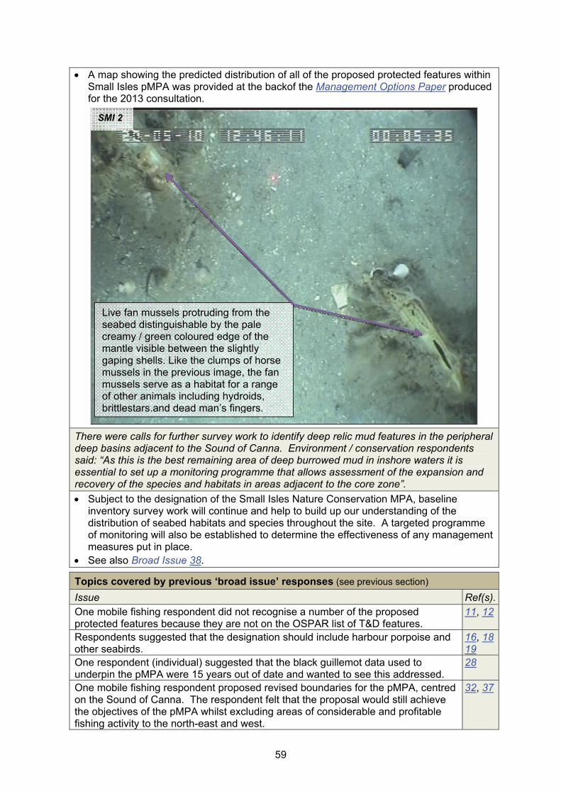
59
A map showing the predicted distribution of all of the proposed protected features within Small Isles pMPA was provided at the backof the Management Options Paper produced for the 2013 consultation.
There were calls for further survey work to identify deep relic mud features in the peripheral deep basins adjacent to the Sound of Canna. Environment / conservation respondents said: “As this is the best remaining area of deep burrowed mud in inshore waters it is essential to set up a monitoring programme that allows assessment of the expansion and recovery of the species and habitats in areas adjacent to the core zone”.
Subject to the designation of the Small Isles Nature Conservation MPA, baseline inventory survey work will continue and help to build up our understanding of the distribution of seabed habitats and species throughout the site. A targeted programme of monitoring will also be established to determine the effectiveness of any management measures put in place.
See also Broad Issue 38.
Topics covered by previous ‘broad issue’ responses (see previous section)
Issue Ref(s).One mobile fishing respondent did not recognise a number of the proposed protected features because they are not on the OSPAR list of T&D features.
11, 12
Respondents suggested that the designation should include harbour porpoise and other seabirds.
16, 18 19
One respondent (individual) suggested that the black guillemot data used to underpin the pMPA were 15 years out of date and wanted to see this addressed.
28
One mobile fishing respondent proposed revised boundaries for the pMPA, centred on the Sound of Canna. The respondent felt that the proposal would still achieve the objectives of the pMPA whilst excluding areas of considerable and profitable fishing activity to the north-east and west.
32, 37
SMI 2
Live fan mussels protruding from the seabed distinguishable by the pale creamy / green coloured edge of the mantle visible between the slightly gaping shells. Like the clumps of horse mussels in the previous image, the fan mussels serve as a habitat for a range of other animals including hydroids, brittlestars.and dead man’s fingers.
60
Respondents noted the partial overlap with the existing SPAs and emphasised the need for MPA management to also consider the requirements of these Natura sites (suggesting that this represented an opportunity to progress management for seabird interests in both designations).
34
There were calls for kelp habitats to be added to the list of protected features. 36 Some respondents felt that this pMPA should be considered in the context of Marine Scotland’s draft seaweed policy statement consultation paper.
36
There were calls from several of the environment / conservation respondents to extend implementation of best practice in the use of anti-predator measures associated with aquaculture facilities to a 5 km radius from black guillemot nest sites to encompass potential black guillemot foraging activity.
36
Respondents suggested that the conservation objectives for all protected features should be to ‘recover’ rather than to ‘conserve’.
37
Summary of any changes arising from the 2013 consultation
No changes are proposed to the Small Isles pMPA protected feature complement or conservation objectives. Any changes in our understanding of the distribution of the proposed protected features since the 2013 consultation will be reflected in the finalised site assessment documents. This will include the results of survey work undertaken in 2013 (Swann, 2013) to assess the status of the breeding black guillemot population within the pMPA. Small landward boundary refinements are recommended to ensure that all habitat at the back of the shoreline considered unsuitable for nesting black guillemots is excluded from the pMPA. Activities information provided by respondents will be incorporated into the finalised Management Options Paper for this site.
2.3.14 South Arran pMPA
Issues with site-specific responses
Some respondents commented that the development of the site boundaries had been too ‘broad-brush’.
In light of comments made regarding the application of a ‘broad-brush’ approach and in discussion with Marine Scotland, SNH reviewed the site boundaries of the pMPAs.
The South Arran pMPA boundary was inconsistent wrt: a number of the generic principles adopted across the rest of the MPA suite (see Broad Issue 32). SNH therefore recommends a simplified site boundary (adoption of a minimum convex polygon). The revised boundary gives rise to a loss of ~6 km2 in area, primarily of burrowed mud habitat around the margins of the site. The simplified boundary will not affect the functional role of the pMPA for the proposed protected features and would facilitate the preparation of a designation order for the site and subsequent management discusions (subject to Ministerial decisions on progression).
Figure A4.7 (Annex 4) illustrates the recommended changes to the South Arran pMPA boundary.
A number respondents to the MPA consultation expressed a preference that the MPA extend all-round the Isle of Arran.
SNH recognises that there may be potential biodiversity benefits associated with calls for an extension of the pMPA. However, we do not have sufficient information to assess the wider area against the MPA Selection Guidelines and therefore do not recommend any change to the proposed boundary (beyond ‘simplification’ - see above).
One local authority noted that within the data confidence assessment produced for this pMPA, whilst there is high confidence in the presence of the proposed protected features, it appears that there is less confidence in the distribution of these features.

61
We have a good understanding of the distribution and extent of the proposed protected features within Lamlash Bay, where previous survey efforts have focused in connection with the No Take Zone (NTZ) established in 2008.
As outlined in the Data confidence assessment document, outwith the NTZ there has generally been a lower intensity of sampling and less information is available to define the extent of individual seabed proposed protected features. This applies particularly to the maerl beds, maerl or coarse shell gravel with burrowing sea cucumbers, and, shallow tide-swept coarse sands with burrowing bivalves features and ocean quahogs.
The programme of survey work completed under the auspices of the Scottish MPA Project over the last 2 - 3 years has greatly improved our understanding of the distribution of the proposed protected features more broadly throughout the pMPA and the results of the most recent sampling in March 2013 (Moore, 2013b; Allen, 2014) have helped us to further refine our initial mapping. This will inform the finalisation of the site documents (please also refer to the feedback provided to issues raised below in relation to selected coarser sediment habitats). The 2013 sampling confirmed the widespread distribution of the ocean quahog Arctica islandica, largely within a band of muddy sands running around the south of the island. Dense siphons constituting 'aggregations’ of the species were observed at one site, building on the results of the 2012 survey work (reported in Moore & Atkinson, 2012), which recorded aggregations of ‘Arctica islandica-like’ siphons at two additional locations. These records have now been confirmed as the ocean quahog A. islandica. The 2013 survey also validated initial predictions regarding the extent and distribution of the burrowed mud proposed protected feature that in some areas was noted as supporting a rich megafaunal component (see also the site-specific issue on the burrowed mud feature within the South Arran pMPA).
These data now supersede the provisional 2013 field results used in the consultation documents (that were labelled as ‘subject to change’).
The work undertaken to date (both the marine biological sampling and a recent review of the evidence-base to refine the feature distribution mapping - see site-specific issue below) has confirmed the presence and broad distribution of all of the proposed protected features within the pMPA. Additional sampling in nearshore waters around the south coast of Arran is recommended in 2014 to refine our understanding of the distribution of these habitats in waters shallower than 15 - 20 m.
In lengthy and detailed responses, mobile fishing respondents submitted views on the 3rd party proposal to draw the boundary for this pMPA at the old 3 mile limit. These respondents said no evidence had been produced, and erroneous assumptions made, in producing the proposal. In addition, the mobile fishing respondents said there had been no corroboration of the evidence submitted to support the existence of maerl at the Iron Rock Ledges.
The evidence used to inform the development of the South Arran pMPA is outlined in the Data confidence assessment and considered in more detail within our site evaluation Detailed assessment against the MPA Selection Guidelines document. Relevant data sources are referenced within both documents with links to published research reports provided where applicable.
The results of the most recent survey work undertaken in 2013 (Allen, 2014 and Moore, 2013b) are available via the SNH commissioned research web pages48 (see Broad Issue 26). Remote video sampling undertaken in 2013 (Moore, 2013b) corroborated the presence of the maerl beds proposed protected feature at the Iron Rock Ledges as initially reported in Howson & Steel (2013).
48 http://www.snh.gov.uk/publications-data-and-research/publications/search-the-
catalogue/?q=commissioned%20report

62
In light of the significance of the concerns raised regarding the quality of the evidence-base underpinning the South Arran pMPA, SNH undertook an audit of available feature records. Further details in relation to the specific concerns raised by respondents regarding SNH Commissioned Report 620 (Howson & Steel, 2013) are provided under the next site-specific issue. Following our consideration of the evidence associated with that report, we cross-referenced existing records with the finalised results of survey work undertaken in 2013 (Moore, 2013b; Allen, 2014). This highlighted possible inaccuracies in the predicted extent of three of the proposed protected features (as displayed in Annex 1 of the Management Options Paper) and / or inconsistencies in habitat assignments by different surveyors / analysts.
To explore these issues in greater detail we commissioned an external review of all of the data available to support three of the nearshore coarse sediment habitat proposed protected features around the south of Arran (namely maerl beds, maerl or coarse shell gravel with burrowing sea cucumbers, and, shallow tide-swept coarse sands with burrowing bivalves).
The relevant data were reassessed to integrate the results from previous surveys employing different biotope assignment criteria with the aim of understanding the distribution of these three habitats. Biotopes were reassigned where this was deemed appropriate and where the level of data (particularly photographic and video imagery) permitted this. In order to more clearly distinguish the distribution and extent of the closely related maerl beds and maerl or coarse shell gravel with burrowing sea cucumbers features, the review adopted a criterion requiring at least 5% cover of living maerl for ascription of the maerl beds feature (NB all sites allocated to maerl beds in the study actually had areas of live maerl cover estimated as >10% - see Moore, 2014 for details). On the basis of the habitat definition adopted, the study re-categorised 12 feature records, of which seven were to habitats that are not considered proposed protected features within the South Arran pMPA.
The work confirmed the presence of all three of the protected features around the south of Arran and in accordance with the consultation site documents, established that live maerl cover is generally very low (most of the live maerl records are of very sparsely scattered thalli), rarely exceeding 5% cover. Following the feature record reassignments, beds of living maerl were confined to small pockets (smaller than originally predicted in the consultation documents but in the same geographical locations) off the south coast in areas of low demersal fishing intensity. These beds are to the south of Iron Rock Ledges and to the north-east of Pladda. Vessel Monitoring System (VMS) data (2007 - 2011) suggests that both areas are subject to low fishing intensity, with dead maerl and sparser live maerl records elsewhere coinciding with markedly higher levels of fishing activity, especially off the south of Holy Isle. Both live maerl grounds occur in relatively shallow water (6 - 17 m) and are close to shallow rocky reefs with pockets of boulders present and so may represent suboptimal conditions for scallop dredging (Moore, 2014). The proportion of live maerl to the south of Holy Isle was insufficient to meet the 5% threshold set for the purposes of the study and the existing predicted feature polygon in this location will no longer be considered in the MPA process (see summary of substantive changes in Table A3.1, Annex 3).
Conversely, the study concluded that the maerl or coarse shell gravel with burrowing sea cucumbers habitat is more widely distributed around the south-western coastline of Arran than previously thought, running from Bennan Head to just north of Drumadoon Point, with a further expansion of the predicted area of this habitat to the south of Holy Isle (encompassing the area previously ascribed to the maerl beds feature).
Recognition of the shallow tide-swept coarse sands with burrowing bivalves feature within the South Arran pMPA is complicated by intergradation with other biotopes and the study concluded that the lack of certainty in feature identification precludes accurate polygon mapping of the distribution of the habitat around the existing records. Whilst confident that the shallow tide-swept coarse sands with burrowing bivalves feature is

63
present, the predicted habitat extent polygons (outwith Lamlash Bay) have therefore also been dropped pending additional sampling effort to refine the currently scattered and widely distributed records of the feature (Allen, 2014).
The proposed changes arising from the internal audit and external review will be carried forward into the completion of the finalisation of relevant supporting documentation (e.g. Data confidence assessments and Detailed assessment against the MPA Selection Guidelines) and the evidence-base underpinning the pMPA.
Moore (2014) identifies more extensive areas, extending approximately to the 20 m depth contour, that incorporate clusters of records of sparse living maerl and relatively unbroken dead maerl, which may represent areas of historically richer maerl. These clusters are around the two confirmed beds to the south of the island but also includean area to the south of Holy Isle. Based on current knowledge and given the requirement for live maerl vegetative propagation to underpin any recovery of the maerl beds feature within the pMPA (conservation objective set to ‘recover’), these areas appear to offer the most suitable targets for possible conservation management action for this feature within the outer parts of the pMPA.
Figure 10 from Moore (2014) shows the revised indicative distribution and extent of the maerl beds and maerl or coarse shell gravel with burrowing sea cucumbers proposed protected features of interest within the South Arran pMPA (apart from Lamlash Bay). The three areas encompassing ‘live maerl record clusters’ represent the most suitable areas for possible conservation management action to support any recovery of the maerl beds feature within the outer parts of the pMPA.
Reproduced by permission of Ordnance Survey on behalf of HMSO. © Crown copyright and database right [2014]. All rights reserved. Ordnance Survey Licence number 100017908. Bathymetry © Crown Copyright, 2014. All rights reserved. Licence No. EK001-201310001. Not to be used for navigation.

64
One mobile fishing respondent cited an SNH commissioned report (CR620) as an example that demonstrates significant issues associated with the data used in the pMPA identification process. The respondent raised concerns that the scrutiny of data entailed the viewing of photographs and dive logs recorded by untrained members of the public, not accompanied by evidence of accurate and corrected position fixing nor of accurate depth recording, thus rendering the records ‘worthless’.
SNH Commissioned Report 620 (Howson & Steel, 2013) presents the findings of a review undertaken to validate records of seabed habitat MPA search features included within the COAST49 third-party MPA proposal50 that were not held by SNH. The study encompassed records from Seasearch and COAST divers. The validation exercise was undertaken by a highly experienced marine biologist using available underwater photographs, video and volunteer diver data recording forms. The findings of the work (a series of validated proposed protected feature records) informed SNH’s subsequent Detailed assessment against the MPA Selection Guidelines.
The review validated a number of records of four of the proposed protected features (PPFs) of the South Arran pMPA (namely, kelp and seaweed communities on sublittoral sediment, maerl beds, maerl or coarse shell gravel with burrowing sea cucumbers, and, seagrass beds). A further PPF, shallow tide-swept coarse sands with burrowing bivalves was considered likely to be present but relevant records were not validated and therefore not used in the MPA assessment process. This feature cannot be confirmed from photos alone, requiring supplementary infaunal sampling and analyses (survey work subsequently undertaken in 2013 confirmed the presence of this feature around the south of Arran - see Allen, 2014 for details). Another MPA search feature, but not one proposed for protection within the pMPA, tide-swept algal communities, was also recorded.
Howson & Steel (2013) found no evidence to support the presence of several other MPA search features included within the original third-party MPA proposal (e.g. horse mussel beds and native oysters). These were not recommended by SNH as proposed protected features of the pMPA.
This ‘atypical’ project (the vast majority of feature records used in the Scottish MPA Project have been derived from statutory agency-led survey and monitoring programmes) represented an opportunity to maximise the potential contribution of volunteer diver observations to the development of the pMPA. It highlighted potential areas of interest for subsequent detailed sampling etc.
In light of the significance of the concerns raised regarding SNH CR 620 we undertook a review of the evidence-base behind the validated proposed protected feature records. Our review highlighted that there was insufficient evidence in relation to three of the COAST data points and these have been dropped from the MPA assessment process. One additional record has been assigned to a different proposed protected feature category. The following bullets provide further details in relation to these changes -
- The study accepted a ‘verbal record’ (KC3) of the maerl beds feature. In the absence of supporting evidence, this record should not have been used. The record is situated within a cluster of other maerl bed records for which recording forms / underwater photos exist and the presence of the feature was verified (within the maerl bed situated to the north-east of Pladda - see Moore, 2014). Therefore although the record was dropped, this has not changed our understanding of where the maerl beds are.
- Recording forms were not available for two of the seagrass bed records (SS11 & SS21). Spatial analysis of these samples indicated that they represented the shoreward ‘entry positions’ for two other seagrass bed records that were verified from survey recording forms. Whilst the shoreward entry points have been removed
49 Community of Arran Seabed Trust - http://www.arrancoast.com/ 50 http://arrancoast.com/website_pdf/COAST_Arran_South_MPA_proposal_9May_FinalP.pdf

65
(because they were essentially duplicates) the associated seaward points on the beds themselves have been retained. This has not affected the predicted extent of the seagrass beds in Whiting Bay which were drawn in the appropriate depth zone away from the shoreline.
- Since publication of SNH CR620 we have received a routine update of formal Seasearch records and adopted their feature assignments for relevant records (as data ‘owners’). This resulted in a change of protected feature category at one location (SB5) where Seasearch assigned the kelp and seaweed communities on sublittoral sediment PPF rather than the maerl beds PPF.
The results of the most recent Marine Scotland-commissioned survey work undertaken in 2013, (presented in Allen, 2014 and Moore, 2013b) have subsequently validated the presence and broad distribution of the four proposed protected features referenced in Howson & Steel (2013). Maerl beds were confirmed off the Iron Rock Ledges (see also the previous site-specific issue for full details), the maerl or coarse shell gravel with burrowing sea cucumbers feature is now known to be widely distributed around the south of the island and off Holy Isle (Moore, 2013b; Moore, 2014) and the shallow tide-swept coarse sands with burrowing bivalves PPF was recorded at multiple discrete locations (Allen, 2014; Moore, 2014). Kelp and seaweed communities on sublittoral sediment were recorded in deeper water along the margins of the seagrass beds in Whiting Bay (Moore, 2013b).
We propose to re-issue SNH CR620 to address the evidential issues identified (removal of relevant records throughout etc.) and also to provide a new ‘evidence’ annex displaying the COAST images and recording forms for relevant PPF records. We believe that this will help improve transparency in the decision-making process by ensuring that the original evidence is available for others to review.
See also the previous site-specific issue in relation to a subsequent external research project undertaken to further refine our understanding of the distribution and extent of specific coarse sediment seabed habitat proposed protected features within the pMPA (Moore, 2014).
On the basis of the detailed assessments provided as part of the consultation, respondents from aquaculture and local authority groups questioned whether the burrowed mud within the South Arran pMPA represents a ‘good’ example of the feature within the network?
Burrowed mud within the South Arran MPA is the most southerly example of this feature within the Scottish MPA network. As well as reflecting the range of this habitat, the geographic setting is considered likely to provide important connectivity between the Clyde sea lochs to the north and the open coast to the south. The feature also conforms to the OSPAR T&D ‘sea-pen and burrowing megafauna communities’51 habitat, with available particle size analysis (PSA) records indicating some heterogeneity in the sediment but likely extensive areas of fine mud plains.
As noted in the Detailed assessment against the MPA Selection Guidelines, it is currently not known whether the low numbers of seapens on the surface of the burrowed mud here, and low numbers of different species living within the muddy substrates in some areas, are linked to pressures e.g. arising from the established Nephrops fishery. It is also unclear whether unmodified / more natural burrowed mud in the Clyde Sea would actually support significantly more diverse associated communities. Based on our current understanding, the proposed protected feature is therefore considered characteristic of burrowed mud within the Clyde Sea.
The MPA Selection Guidelines (2d) clarify that whilst the identification of MPAs initially focused on least damaged / more natural examples of features, the network is expected to contain some features that have been modified by human activity. Whilst respondents asked whether the burrowed mud within the South Arran MPA is a ‘good’
51 SS.SMu.CFiMu.SpnMeg habitat code.

66
example, our focus in determining whether or not it should be recommended as a proposed protected feature was on whether it would make a significant contribution to the network in Scotland’s seas. In our view it would make a significant contribution.
The most recent remote video sampling work within the pMPA (Moore, 2013b) observed that the pMPA encompasses ‘an extensive development of high quality burrowed mud (SS.SMu.CFiMu.SpnMeg) in deeper water, with a rich megafaunal component’.
See also Broad Issues 12, 13 and 15.
The mobile fishing respondents indicated that seagrass beds are already protected.
SNH understands that this observation relates to our existing assessment which considers seagrass beds to be adequately represented within the Scottish MPA network in OSPAR Region III (see Carruthers et al., 2011 for details of the contribution of existing protected areas to the MPA network and Table A6.1, Appendix 6 of our 2012 MPA network advice - SNH & JNCC, 2012a).
Within the 2012 MPA network advice we highlight that ‘the seagrass beds within the South Arran pMPA are not required to achieve adequacy [see Broad Issue 2 for details regarding the adequacy assessment] because of the protection already provided by existing measures’.
Seagrass beds52 are of considerable ecological and biodiversity importance. They can support a high density and diversity of associated flora and fauna, and may provide valuable nursery and feeding grounds for fishes, including some commercially important species (Davison & Hughes, 1998). Collectively, the beds within the South Arran pMPA represent the largest known area of this habitat within the Clyde Sea.
We have recommended the inclusion of the seagrass beds here to add to the integrity of the pMPA and to complement existing protection in OSPAR Region III. The beds would represent the most southerly known examples of the feature within the Scottish MPA network.
Topics covered by previous ‘broad issue’ responses (see previous section)
Issue Ref(s).There were calls from individuals, environment / conservation groups and a local group for seabirds (including black guillemots), basking sharks and coastal mammals (e.g. otters and seals etc.) to be protected within this pMPA.
8, 17
Mobile fishing respondents commented that kelp and seaweed communities on sublittoral sediment, shallow tide-swept coarse sands with burrowing bivalves and maerl or coarse shell gravel with burrowing sea cucumbers, do not appear on the OSPAR list of threatened and/or declining species.
12, 13
Respondents, from the environment / conservation group asked that the objectives for protected features in all three pMPAs in the Clyde be set to recover rather than conserve as there is evidence of a decline in species richness.
33
Summary of any changes arising from the 2013 consultation
No changes are proposed to the South Arran pMPA protected feature complement or conservation objectives. The provisional results from survey work undertaken in 2013 were included in the MPA consultation materials and these will be updated within the finalised site documentation in spring 2014. The proposed changes arising from our internal audit and external commissioned review (Moore, 2014) will also be carried forward into relevant supporting documentation and the underpinning evidence-base. Refinements to the site boundary are recommended to reflect the full implementation of boundary setting principles (shown in Figure A4.7; Annex 4). Activities information provided by respondents will be incorporated into the finalised Management Options Paper for this site.
52 http://www.snh.gov.uk/about-scotlands-nature/species/flowering-plants/coastal-and-marine-
plants/eelgrass/

67
2.3.15 Upper Loch Fyne and Loch Goil pMPA
Issues with site-specific responses
Environment / conservation responents wanted to see fireworks anemones and the Artic relic seasquirt Styela gelatinosa in Loch Goil added to the protected features as well as the sheltered rock reefs in both lochs.
Fireworks anemones are an integral component species of the burrowed mud feature within both discrete parts of the Upper Loch Fyne and Loch Goil pMPA. These anemones are most numerous within Loch Shira in Upper Loch Fyne but as outlined in the Detailed assessment against the MPA Selection Guidelines, they are also present around the mouth of Loch Goil, along the gently sloping shelves on the eastern side of the loch and at its head.
The Arctic sea squirt Styela gelatinosa is encompassed within the sublittoral mud and mixed sediment communities representative feature of the pMPA (as the characterising species of one of the component habitats - scientific ref. code SSMu.OMu.StyPse). Within the site assessment document, we note that considerable uncertainty remains regarding the current status of this species which has not been recorded since being found in large numbers during the 1989 Northern Clyde sea lochs survey of Loch Goil.
Our initial assessment of the coverage of seabed habitats within the MPA network (at EUNIS Level 3) concluded that sheltered rocky reefs were adequately represented within OSPAR Region III. Therefore the reefs within the pMPA were not recommended as proposed protected features.
Environment / conservation responents raised concerns about the resolution of the protected feature mapping - seeking clarity regarding the distribution of fireworks anemones and mud volcano worms.
The distribution of the component habitats and species of the burrowed mud proposed protected feature within the Upper Loch Fyne and Loch Goil pMPA is described within the Detailed assessment against the MPA Selection Guidelines and mapped within the Management Options Paper for this site (see Map 2).
One local authority respondent believed that there were inconsistencies between site-specific documents regarding the conservation objective set for burrowed mud within the pMPA and requested that these be clarified and corrected where appropriate.
The conservation objective for burrowed mud feature within the Upper Loch Fyne and Loch Goil pMPA was set to ‘conserve (feature condition uncertain)’ at the time of the 2013 MPA consultation (see Broad Issue 37 in relation to the terminology used).
This conservation objective was stated within the Site summary (shortened for simplicity in this succinct document against an aim to ‘conserve’), Detailed assessment against the MPA Selection Guidelines and the Management Options Paper. No details regarding conservation objectives were provided in the Data confidence assessment document.
The draft conservation objective for the burrowed mud feature in this pMPA presented within our earlier 2012 MPA network advice was given as ‘recover’ (see greyed text in Table A5.1, Appendix 5 of SNH & JNCC, 2012a).
An addendum53 to our 2012 advice (SNH & JNCC, 2012a) provides full details of any changes made to the feature complement of the pMPAs and their respective conservation objectives prior to the launch of the MPA consultation in 2013.
An aquaculture respondent asked for clarification on the pressures that sublittoral mud and mixed sediment communities are sensitive to as, they commented, this feature is not considered in the Feature Activity Sensitivity Tool (FEAST matrix).
53 http://www.snh.gov.uk/docs/A1005868.pdf
68
Issues with site-specific responses
Work is currently underway to confirm the pressures to which the sublittoral mud and specific mixed sediment communities proposed protected feature are sensitive (see Broad Issue 24 for recommended changes to the name of this feature within the pMPA).
For the purposes of the consultation version of the Management Options Paper, we considered a number of the more sensitive component species that characterise the different habitats comprising this broad proposed protected feature, these included slender seapens and horse mussels.
The conclusions of the final proposed protected feature sensitivity assessment will be made available through FEAST shortly.
An aquaculture respondent asked whether the sublittoral mud and mixed sediment communities feature would be managed in a different way because it wasn’t an MPA search feature.
As outlined under Broad Issue 24, a number of broad sublittoral sediment habitats were proposed as protected features within six of the pMPAs to ensure that the MPA network encompasses the range of habitats and species considered representative of Scotland’s seas more generally.
Further details on the sublittoral mud and specific mixed sediment communities feature within the Upper Loch Fyne and Loch Goil pMPA are provided within the Detailed assessment against the MPA Selection Guidelines document.
Following the assessment against the guidelines, this representative feature and the applicable MPA search features (e.g. flame shell beds) became proposed protected features of the pMPA. All of the proposed protected features are treated in the same way, with conservation objectives set for each and management options identified on the basis of the perceived risk of the feature not achieving these objectives.
A respondent (individual) sought clarity about the implications of the MPA for rod and line fishing within Loch Fyne.
Without prejudicing any future advice SNH may give on this issue, we do not envisage any requirement to restrict recreational rod and line fishing within the Loch Fyne area of the pMPA.
See Broad Issue 34 (general approach to MPA management).
Environment / conservation respondents sought clarification as to how protection for the low or variable salinity habitats feature is being progressed now that the feature has been dropped from the pMPA.
The low or variable salinity habitats feature is afforded protection as part of qualifying or notified features within a number of existing protected areas (SACs and SSSIs) within OSPAR Region III. Further details are provided in Appendix 6 of our 2012 MPA network advice (SNH & JNCC, 2012a).
Topics covered by previous ‘broad issue’ responses (see previous section)
Issue Ref(s).An environment / conservation respondent wanted all conservation objectives to be set to ‘recover’ rather than ‘conserve’.
37
Environment / conservation respondents highlighted the need for monitoring of activities to ensure these did not affect achievement of the conservation objectives.
38
Some respondents disagreed wth SNH’s recommendations on trawling and dredging, suggesting the need for ‘proper regulation’ such that these activities should not take place within the Clyde pMPAs.
34, 45 46
One environment / conservation respondent said that a more holistic approach to managing fishing activity across all three Clyde pMPAs should be adopted and that the cumulative impact rather than case by case should be considered.
43, 45

69
Summary of any changes arising from the 2013 consultation
No changes are proposed to the Upper Loch Fyne and Loch Goil pMPA protected feature complement, conservation objectives or site boundary. The provisional results of the 2013 survey were included in the MPA consultation materials and these will be updated in the finalisation of the site documentation in spring 2014. Activities information provided by respondents will be incorporated into the finalised Management Options Paper for this site.
2.3.16 Wester Ross pMPA (formerly North-west sea lochs and Summer Isles54)
Issues with site-specific responses
Environment / conservation respondents supported the designation or called for it to be extended to cover “all maerl beds and other seabed habitats used as fish spawning grounds around Wester Ross”. In particular, most individuals wanted to see the area extended to include Loch Gairloch.
SNH does not currently have sufficient information regarding the distribution and significance of fish spawning grounds more broadly around the Wester Ross coastline (and the relationship with different seabed habitats in this regard) to inform an assessment against the MPA Selection Guidelines.
Loch Gairloch and Wester Loch Ewe were assessed at an earlier stage in the Scottish MPA Project as part of our consideration of the third-party proposal submitted by the Gairloch and Wester Loch Ewe Community. The assessment was underpinned by good recent survey information for this area (Moore et al., 2011) and recommended that only Loch Ewe should be considered further. Part of the reason for this is that including Loch Gairloch would not add anything different to the MPA network. Loch Gairloch is afforded some spatial protection through existing fisheries management measures.
Therefore, whilst SNH recognises that there are potential biodiversity benefits associated with the calls for an extension of the pMPA and the inclusion of diverse biogenic habitats such as maerl beds more generally, we do not recommend any specific boundary changes. See also Broad Issue 9.
Aquaculture respondents and one individual questioned the scale of the pMPA. They felt that the boundary relates to geographically convenient reference points rather than delineating the protected features. The respondents felt that the pMPA should be smaller and focus on specific locations / features, which they felt were primarily situated close to the shore.
See Broad Issues 32 and 33 (these describe how were the boundaries of the pMPAs were derived and their relationship with management boundaries).
As outlined in the Detailed assessment against the MPA Selection Guidelines for this pMPA (see Stage 3), the proposed boundary was drawn to encompass the distribution and extent of the range of proposed biodiversity and geodiversity protected features. The outer north-western boundary encompasses records of the burrowed mud with tall seapens habitat in an exposed open coast setting, as well as the more sheltered examples of this feature around the Summer Isles and within the three sea lochs. The lateral extents of the possible MPA at Rubha na Còigach to the north-east and Rubha Rèidh to the west mirror the outer margins of the Summer Isles to Sula Sgeir Fan key geodiversity area (see SNH Commissioned Report No. 432 - Brooks et al., 2013 for details), maximising the representation of the Quaternary of Scotland geodiversity feature. Our view is that the proposed boundary is suitable for maintaining the integrity of the features for which the MPA is being considered.
54 As a result of feedback received during the 2013 MPA consultation we have changed the name of
the North-west sea lochs and Summer Isles pMPA to the Wester Ross pMPA.
70
One respondent (individual) felt that burrowed mud should not be included as a proposed feature of the pMPA. A mobile fishing respondent proposed that only the larger aggregations of tall seapens (part of the burrowed mud feature) within the inner lochs needed protecting.
The Wester Ross pMPA provides representation of burrowed mud with tall seapens within sheltered sea loch settings but also in an exposed, open coast setting towards the outer boundary of the site. This represents distinct and important aspects of geographic and ecological variation.
See Broad Issues 1, 2 and 12 in relation to the representation and replication of features within the Scottish MPA network, Stage 5 of the MPA Selection Guidelines, and the burrowed mud MPA search feature.
A number of respondents suggested that the area should be the Wester Ross MPA to give a clear local identity, foster local interest and give a greater sense of local ownership.
SNH supports the proposed change in the name of the pMPA and recommends that the North-west sea lochs and the Summer Isles pMPA now becomes the Wester Ross pMPA.
A mobile fishing respondent voiced concerns regarding the evidence relating to a number of features including the maerl or coarse shell gravel feature and northern feather star aggregations on mixed substrates.
Within the Detailed assessment against the MPA Selection Guidelines and Data confidence assessment documents we note that considerable uncertainty remains regarding the current status of the maerl or coarse shell gravels with burrowing sea cucumbers feature within the pMPA. There are only three records of the feature and these date back to 1996. All three of these locations were resurveyed in 2010 and were assigned to a coarser resolution (non-protected feature) habitat in the absence of evidence of the presence of the characterising sea cucumbers (Moore et al., 2011).
The feature, which is frequently encountered in circalittoral dead maerl plains adjacent to maerl beds (another recommended feature of the pMPA), was proposed for protection to provide additional representation within the MPA network. The three 1996 records lie adjacent to maerl beds around the Summer Isles.
The habitat can be difficult to identify with certainty because the characterising sea cucumber is a permanently infaunal species that exhibits periodicity in emergence of its feeding tentacles. However, occurrences of suitable habitat and the potential presence of the feature were noted in all areas of the possible MPA surveyed in 2010 apart from Loch Broom (where it is probably absent due to the sheltered conditions) and Gruinard Bay (where it is likely to be present) (Moore et al., 2011).
The Detailed assessment against the MPA Selection Guidelines also provides the details of our understanding regarding the status and distribution of the northern feather star aggregations on mixed substrata feature within the pMPA. Dense fields of this species on mud and muddy sand substrates with scattered cobbles at the mouth of Loch Broom, and on the inner and outer sills of Little Loch Broom, have persisted in these locations since the early 1990s (see Moore et al., 2011 and Moore, 2012 for details). Moore (2012) considers dense northern feather stars to extend over an area in the order of 2 ha on the outer sill of Little Loch Broom but notes that the north-eastern margin of the aggregation remains poorly defined.
Video footage from the survey work undertaken in 2011 (reported in Moore, 2012) is available on the Marine Scotland Science (MSS) YouTube pages. Examples of video samples that observe dense northern feather star aggregations on mixed substrata (on the outer sill of Little Loch Broom) include MV306 and MV307. The descriptive details

71
for these sampling stations are provided in Appendices 1 and 2 of Moore (2012). On the MSS YouTube pages the corresponding video files are labelled as TV30655 and TV30756 (together with the date and sampling location).
Other respondents wanted to see research to investigate interactions between active / mobile gear and the protected features.
SNH are currently exploring collaborative research opportunities to investigate the interactions between the pressures arising from different anthropogenic activities and a number of the proposed protected features. This is particularly relevant to those features where management options to ‘reduce or limit’ such pressures have been proposed.
See also Broad Issues 38 and 43.
Topics covered by previous ‘broad issue’ responses (see previous section)
Issue Ref(s).There were calls to add seagrass beds and sea trout to the protected features. 8, 9 One mobile fishing respondent did not recognise a number of the proposed protected features because they are not on the OSPAR list of T&D features.
11, 12
Environment / conservation respondents recommended that harbour porpoise be added as a protected feature.
18, 19
Summary of any changes arising from the 2013 consultation
We recommend that the North-west sea lochs and Summer Isles pMPA be renamed as the Wester Ross pMPA. No changes are proposed to the Wester Ross pMPA protected feature complement, conservation objectives or site boundary. Any changes in our understanding of the distribution of the proposed protected features since the 2013 consultation will be reflected in the finalised site assessment documents (see Broad Issue 26). Activities information provided by respondents will be incorporated into the finalised Management Options Paper for this site.
2.3.17 Wyre and Rousay Sounds pMPA
Issues with site-specific responses
One local group wanted to see the pMPA extended around the south and east of Wyre.
SNH recognises that there may be potential biodiversity benefits associated with the call for an extension of the pMPA. However, SNH does not have any information on the distribution of the MPA features to the south of Wyre and are therefore not in a position to recommend any change to the initial proposal. The area of the pMPA meets the requirements of the Scottish MPA Selection Guidelines in terms of shape and size and ability to maintain the integrity of the proposed protected features.
One mobile fishing respondent sought reassurances regarding credible evidence and clarity in relation to the rarity of the features proposed for protection. The same respondent felt that the proposed boundary was rather ambiguous wrt: the known distribution of the protected features.
SNH recognises that maerl beds are widely distributed in the high quality clear waters around Orkney. Orkney represents a stronghold for this biologically-rich seabed habitat and whilst not rare per se in this region, our improved understanding on the distribution of this habitat in Scottish waters emphasised the need for enhanced representation in the Northern Isles (we have also included this as a proposed feature within the Fetlar to Haroldswick pMPA). Kelp and seaweed communities on sublittoral sediment are already quite well represented within the MPA network and the feature is not required
55 http://www.youtube.com/watch?v=prCl56NHCgE&list=PL0DA9E070E7EBE934 56 http://www.youtube.com/watch?v=Lxz_BI88Fmo&list=PL0DA9E070E7EBE934

72
within the Wyre and Rousay Sounds pMPA to achieve adequacy but is recommended to add to the integrity of the proposal (because it is interspersed with the maerl beds feature).
The proposed boundary for the pMPA was drawn around the margins of the sounds, and recognises these as functional ecological units. There is potential for management boundaries to be drawn within this wider site boundary if only parts of the site need to be managed. SNH recognises that there are still gaps in survey coverage within the pMPA and would be interested in exploring opportunities to fill these gaps in collaboration with local stakeholders.
We do not have a detailed understanding of the wider distribution of the protected features in adjacent areas and therefore do not propose any extension to the current boundary (see previous site-specific issue).
A recreation / tourism respondent was concerned about the effect on maerl beds of a number of salmon farms in the area. The same respondent raised concerns in relation to wild fish and the proximity of aquaculture facilities to known sea trout spawning burns.
The fish farms within Wyre and Rousay Sounds have been in operation since 1987. The footprint of waste deposition (known as the AZE - Allowable Zone of Effect) is modelled by SEPA and is regulated through farm compliance monitoring, audit and inspection of farms. This monitoring (which includes seabed sampling for biological, chemical and physical parameters) is to ensure the level of impacts do not breach environmental quality standards.
As highlighted within the Management Options Paper, there are three finfish farms located within the pMPA at Kirk Noust, Bay of Vady and Bay of Ham. The fish farm at Kirk Noust lies very close to maerl records whilst those at Bay of Vady and Bay of Ham lie further away from records of both maerl and kelp and seaweed communities on sublittoral sediment. Any impacts on the maerl beds at Kirk Noust will have already occurred and it is unlikely the continued operation of these sites would contribute to a deterioration in the current condition of the feature. However, there is a risk to achieving the conservation objectives for the maerl beds and kelp and seaweed communities on sublittoral sediment from future development and any plans for new fish farms or expansion of current farms would need careful consideration.
As outlined under Section 2.3.3 (Fetlar to Haroldswick pMPA site-specific issues), there is no legal duty to carry out a review of existing licence consents within newly designated Nature Conservation MPAs. This means that existing licensed operations are normally expected to continue as consented.
The main risks that salmon farms pose to wild salmonids are from escapes (potential genetic implications / disease transfer) and elevated sealice levels. The Aquaculture and Fisheries (Scotland) Act 2007 gives the Fish Health Inspectorate powers to enforce regulations over both containment and sealice levels at fish farm sites and carry out regular inspections and audits. SNH supports the industry Code of Good Practice standards for sealice control and the recently adopted Scottish Technical Standard for containment issues.
A mobile fishing respondent queried a limit on hand-diving saying that “if conserving maerl is the objective of the designation then this management option would seem to be irrelevant.”
SNH considers that management for the maerl beds feature of interest should consider human activities that have the potential to affect the structure and functional role of the beds, including diver harvesting of bivalves such as scallops. As noted in the respondent’s consultation submission, infaunal bivalves are an important component of biodiversity within maerl communities and unsustainable diver collection can result in removal of large, fecund individuals from the population broodstock. The objective of the pMPA is not solely the conservation of a proportion of ‘live’ maerl, rather, that the maerl beds remain healthy with a biodiverse associated community that can in turn continue to serve as a source of harvestable bivalves in the long-term.

73
Topics covered by previous ‘broad issue’ responses (see previous section)
Issue Ref(s).Environment / conservation respondents wanted to see objectives for all protected features in this area as recover rather than conserve.
37
There were calls from environment / conservation groups to monitor the potential effects of fisheries activities on the proposed protected features.
38
Summary of any changes arising from the 2013 consultation
No changes are proposed to the Wyre and Rousay Sounds pMPA protected feature complement, conservation objectives or site boundary. Any changes in our understanding of the distribution of the proposed protected features since the 2013 consultation will be reflected in the finalised site assessment documents (see Broad Issue 26). Activities information provided by respondents will be incorporated into the finalised Management Options Paper for this site.
2.4 Opportunities identified
Marine Scotland (2014a) concluded that of the 332 discrete consultation responses, most (257) supported the development of the MPA network in Scotland’s seas. 14,628 campaign responses also expressed their support. Few (12) said that they did not support the development of the network and these respondents came from individual and mobile fishing groups. This group expressed concern that the impact on mobile fishing would have disproportionate consequences for both individual concerns and on coastal communities. They felt that the designation and management of Nature Conservation MPAs would:
“……. substantially, and quite unnecessarily, reduce fishing in Scotland’s Seas endangering, at one and the same time, employment and well-being, in coastal Scotland and the Country’s food security.”
Many of the consultation responses considered the potential benefits and disbenefits associated with the designation of pMPAs in Scotland’s seas (both in terms of likely direct and indirect effects). Marine Scotland will be considering all of the points raised in more detail when finalising the MPA network Impact Assessment and the site-specific Business and Regulatory Impact Assessments (BRIAs).
Within this section of the report we provide a summary of some of the benefits proposed by those respondents supportive of the development of the MPA network that are often hard to quantify. We use quotes drawn from a number of different consultation submissions.
2.4.1 Sustaining local economies
The potential links between pMPAs and the maintenance of sustainable local economies were explored in a number of responses:
“The message for the North-west sea lochs and the Summer Isles pMPA [now Wester Ross pMPA] is that there is substantial scope for tangible socio-economic benefits to offset any perceptions of negative impact (real or otherwise) from essential management measures”.
“For many small coastal communities a rich environment and fully functioning ecosystem underpin the entire economic structure - in our case particularly nature tourism, arts, crafts and cultural identity with the sea”.

74
“Additionally, [as] we are in a Priority Regeneration Area, and as a sustainable economy is given as one of the five guiding principles, protecting the rich wildlife of the area is one way to assist this aim”.
There are currently very few detailed case studies available to support many of the comments made regarding the potential socio-economic and other benefits of MPAs for local coastal communities in a Scottish context. Suitable studies will form an important aspect of future assessments of the success of the network. 2.4.2 Benefits to the fishing industry
Some respondents highlighted the potential negative socio-economic consequences for the fishing industry from MPA designation. However, others saw the creation of MPAs as vital to maintaining and improving both Scotland’s commercial and recreational fisheries. Respondents pointed to evidence from MPAs around the world and weighed the longer-term benefits to the industry against potential short-term costs. The protection of seabed habitats that serve as spawning and nursery areas (e.g. maerl and seagrass beds), was considered vital to the continuation of Scotland’s sea fishing industry as well as playing a potential role in the conservation of sea trout and Atlantic salmon.
“It might reasonably be speculated that exclusion of fishing activities from a particular area now may result in long-term benefits in terms of the site becoming a nursery area from which mature fish can enter the fishery in the longer-term, potentially providing greater benefits for future generations”.
“The effective implementation of an MPA network around Scotland can help to protect and recover marine habitats some of which we believe are of importance to valuable fin-fish species including sea trout (sea-going brown trout), populations of which collapsed around Skye during the 1980s and 1990s”.
“There is much potential for the restoration of fish and shellfish populations associated with the recovery of seabed habitats within the area. I believe that the successful development of the MPA will benefit the majority of local fishing business by helping to promote harvesting methods and management that can secure the long-term sustainability of fisheries resources of the area”.
In relation to fisheries, SNH acknowledges that the pMPAs (and the proposed protected features within them) are relevant to fisheries management considerations, and that they may be able to make a contribution to the sustainability of (certain) fisheries, but this role needs to be viewed in the context of the fishery as a whole and should not be over-estimated. The MPAs were not identified to serve as a fisheries management tool. But nonetheless there is a relationship between the management of MPAs and fisheries. 2.4.3 Recreation and tourism
The suggested benefits pMPAs may bring for sport and leisure activities mainly revolved around the continued existence of a diverse range of habitats for a range of pursuits, the role pMPAs may have in maintaining or recovering the numbers of a given target species, or more general cleanliness and health of the marine environment to support and enhance leisure activities (ensuring that diving, angling, sailing, wildlife watching and snorkelling remain high quality experiences). A significant number of responses noted the transition that many Scottish coastal and island communities are making to tourism-based economies. While some responses provided a more anecdotal account on the increased value of local tourism over the years, a number of

75
responses pointed towards specific sectors or geographic areas and quoted figures such as tourism numbers and overall spend. Collectively these responses emphasised the current value tourism brings to the local economies and the tangible benefits pMPAs could bring to local tourism operators and wider service providers (accommodation, food and transport).
“In 1999 there was one wildlife tourism boat and one angling boat operating out of Gairloch. Come 2013, eight boats now have some involvement in the exploitation of natural resources for tourism”. “The Scottish sailing tourism industry is estimated to contribute between £101m (SE, 2010) and, depending on definition, £200m (Mackenzie Wilson, 2006 [SE, 2006]) each year to the economy and supports in excess of 2730 FTE jobs (SE, 2010). Indeed Mackenzie-Wilson (2006) suggest that including tourism this reaches as high as 7000 FTE jobs”. “The Scottish Government’s own figures show marine wildlife tourism contributes £63 million to the Scottish economy annually57”. “A recent report (Kenter et al., 201358) indicates the annual current recreational use value of diving and angling in 20 of the proposed MPAs is £67 million - £117 million”. “Recovery of marine habitats would help valuable wild fish populations including sea trout, herring, cod, haddock, various flatfish and other species; and could help to support and regenerate a valuable angling tourism industry”.
2.4.4 Ecosystem services
Exploring the points raised on the indirect benefits of MPAs, a number of responses recognised that at a basic level pMPAs will support our marine environment and help it to continue to deliver the ecosystem services currently provided. Food production, carbon sequestration and storage, and coastal protection were just a few of the services noted by respondents.
“The Council recognises the important contribution that marine biodiversity and geodiversity make to support the services that seas supply to society”.
2.4.5 Intrinsic benefits
A number of respondents considered the less quantifiable benefits that pMPAs may bring to individuals and local communities. Existence values were discussed; the value or benefit that people place on simply knowing that something exists, even if they will never see it or use it. Some responses explored this aspect using intergenerational equity, the notion our seas should be protected for our children and grandchildren. Others highlighted the non-use monetary values of pMPAs, quoting figures from both the Scottish Government’s Sustainability Appraisal (Scottish Government, 2013) and an economic-worth study of recreational diving and angling within the pMPAs.
57 http://www.scotland.gov.uk/Resource/Doc/311951/0098489.pdf 58 Note that wording used by the respondents could be taken to mean that the study by Kenter et al.
found that the figures quoted represented the likely spend associated with use of the possible MPA by recreational users. Our understanding is that the figures quoted represent the values that recreational users stated a possible MPA would be worth to them, regardless of whether or not they were likely to visit a particular site.

76
“The Scottish Government’s Sustainability Appraisal for the MPA network estimated the range of non-use values of Scottish waters by Scottish households at between £239 million and £583 million”. “I count myself as privileged to have seen so many wonderful and beautiful wild animals whilst diving around Scotland but fear that the opportunities for those younger than me to witness such wonder are diminishing”.
3. SUMMARY AND RECOMMENDATIONS
There was support for an MPA network from almost all of the 14,703 respondents. Many also stressed the need for protection of the marine environment. Marine Scotland requested that SNH consider the scientific and evidential aspects of 137 discrete responses. The JNCC considered a subset of responses focusing on the pMPAs in offshore waters and have provided separate post-consultation advice on these to Marine Scotland (JNCC, 2014). Respondents commented on a range of higher-level aspects regarding MPA network design and the selection process through to more detailed site-specific issues. The individual pMPAs attracted varying levels of comments, generally reflecting the perceived implications of future management. We have provided feedback on relevant scientific and evidential concerns raised through the consultation. This included comments on site boundaries, conservation objectives, the proposed protected features, and the management options. Note that many of the questions raised in relation to management, including for fisheries, are outwith SNH’s remit. We expect Marine Scotland will consider these comments when developing management measures. We recognise that at present there is not complete certainty in terms of how best to achieve the conservation objectives across the full range of protected features in the different Nature Conservation MPAs. Therefore, alongside our advice on management options, and Marine Scotland’s developing work on management measures, we are also working to develop collaborative research projects that will enable decisions to be better informed in future. 3.1 Overview of proposed changes to the suite of pMPAs
In light of comments made regarding the application of a ‘broad-brush’ approach to boundary setting, SNH reviewed the site boundaries of all of the pMPAs within territorial waters. We recommend changes to the outer boundaries of seven individual pMPAs which collectively reflect the full implementation of the boundary setting principles set out in the Scottish MPA Selection Guidelines. The seven pMPAs are East Caithness Cliffs, the Monach Isles, Noss Head, Loch Sunart to the Sound of Jura, Lochs Duich, Long and Alsh, the Small Isles, and South Arran. For the three pMPAs that include black guillemot as a proposed protected feature (East Caithness Cliffs, Monach Isles, and the Small Isles), these changes represent small alterations to the landward boundaries to ensure that only habitat considered suitable for breeding birds is included. For Noss Head, we have recommended drawing the boundary closer to our records of horse mussel beds and for Loch Sunart to the Sound of Jura we have recommended excluding three harbour areas from the site boundary. For South Arran, following discussion with Marine Scotland, we have recommended drawing the site boundary using a minimum number of straight lines as per our boundary setting principles. This does not change the proposed protected features for this site (see also the paragraph below for further discussion

77
of South Arran). We propose a small extension to the Lochs Duich, Long and Alsh pMPA to reflect the findings of recent survey work (March 2014) and the exciting revelation that the flame shell bed proposed protected feature within the Kyle Akin Narrows is even larger than first thought. The bed, which is believed to support at least 100 million individual flame shells, was considered the largest known example of this habitat in the world when first mapped in 2012. A small number of consultation submissions suggested that the boundaries of specific pMPAs (Wester Ross and the Small Isles) should be extended. We had sufficient information to carry out an assessment for the proposed Wester Ross extension, however, our recommendation is that the proposed extension is not required to achieve adequacy of coverage of the features concerned (maerl beds etc.). We do not have sufficient information to undertake a full assessment for the proposed extension of the Small Isles pMPA to include sea lochs along the south coast of Skye. We therefore recommend that the boundary of the Small Isles pMPA remains as originally recommended but that additional information gathering be undertaken to inform a detailed assessment of the merits of the proposed extension as part of the first review of the network in 2018. A number of consultation responses queried the evidence-base for the South Arran pMPA. We summarise the findings of an audit undertaken to review the evidence-base. Insufficient evidence was available to support a small number of individual records of the proposed protected features and these will be dropped from the MPA process. We commissioned a follow-up study (Moore, 2014 - SNH Commissioned Report 749) in an attempt to more clearly distinguish the distribution and extent of three of the seabed sediment proposed protected features within that site (maerl beds, maerl or coarse shell gravel with burrowing sea cucumbers, and, shallow tide-swept coarse sands gravel with burrowing bivalves). The study recommends refinements to a number of the individual protected feature records and also to the current predicted extents of these habitats. These changes in our understanding of the distribution of the proposed protected features will be carried forward into the finalised site assessment documents and evidence-base for the South Arran pMPA. In summary, we recommend that there is sufficient evidence to support all of the proposed protected features recommended for designation as part of the South Arran pMPA. SNH Commissioned Report 620, which provided a review of the data submitted by the Community of Arran Seabed Trust (COAST) as part of their third-party MPA proposal, will be republished to reflect the results of our recent audit. The COAST seabed habitat images and Seasearch recording forms that relate to the proposed protected feature records subsequently used in the MPA process will be included as an annex to the republished report (to improve transparency in the decision making process). We propose a series of changes to the draft Management Options Papers prepared for the pMPAs. These include edits to reflect the helpful feedback received during the consultation and ongoing work to refine our data on activities (e.g. in relation to anchorages and aquaculture facilities). On review of the draft MOPs, it became clear that there were a small number of inconsistencies between the papers in the way that they addressed the interactions between different activities and features. Changes have been recommended to address these as well as to clarify (but not change) our advice in some papers e.g. being more specific about whether our advice applies across the whole of a pMPA. We have also now completed our work on the management of geodiversity features and, as a result, have identified additional management options for two sites, the Monach Isles and Papa Westray. The substantive changes arising from our detailed consideration of the consultation responses reviewed are outlined in Table A3.1, Annex 3.

78
3.2 Recommendations and next steps
SNH recommends designation of all 17 of the pMPAs in Scottish territorial waters that were part of Marine Scotland’s public consultation in 2013. This is subject to the changes we have recommended following consideration of the consultation responses and our subsequent review of the supporting evidence. The detail of recommended changes is presented in Section 2.2 and the recommended pMPAs are shown in Figure 3. SNH will update and finalise all site documents in late spring 2014 to support decisions by Scottish Ministers on which sites to designate as Nature Conservation MPAs. The revised documents will reflect the changes we have recommended to individual pMPAs. SNH will continue to support Marine Scotland in their work on the development of management measures, including engaging with stakeholders. Pending decisions on designation, SNH will also support Marine Scotland in the development of management plans for these sites. Following Ministerial decisions on which sites to designate, SNH and JNCC will update our assessment59 of the coherence of the Scottish MPA network and the contribution that it would make to wider networks. This revised assessment will also take account of any progress made in ongoing work on the suite of Natura sites i.e. marine SPAs and SACs.
59 See Section 9 and Appendix 9 of SNH & JNCC (2012a) for further details.

79
Figure 3. Possible Nature Conservation MPAs in Scottish territorial waters recommended to Minsters for designation in 2014 (this map does not show the remaining 4 MPA search locations in territorial waters or the pMPAs in Scottish offshore waters which are the subject of distinct separate advice packages to Marine Scotland).

80
4. REFERENCES
Allen, J.H. 2014. Infaunal and PSA analyses of grab samples collected from the Clyde Sea, in March 2013. Scottish Natural Heritage Commissioned Report No. 745. Available from <http://www.snh.org.uk/pdfs/publications/commissioned_reports/745.pdf> Ardon, J.A. 2008. Three initial OSPAR tests of ecological coherence: heuristics in a data-limited situation. ICES Journal of Marine Science 65: 1527-1533. Axelsson, M., Allen, C. & Dewey, S. 2012. Infaunal analysis of grab samples collected from Canna, Small Isles, in June 2011. Scottish Natural Heritage Commissioned Report No. 504. Available from <http://www.snh.org.uk/pdfs/publications/commissioned_reports/504.pdf> Bates, C.R., Moore, C.G., Harries, D.B., Austin, W. & Lyndon, A.R. 2004. Broad scale mapping of sublittoral habitats in Loch Sunart, Scotland. Scottish Natural Heritage Commissioned Report No. 006. Available from <http://www.snh.org.uk/pdfs/publications/commissioned_reports/F01AA401C.pdf> Baxter, J.M., Boyd, I.L., Cox, M., Donald, A.E., Malcolm, S.J., Miles, H., Miller, B. & Moffat, C.F., (Editors). 2011. Scotland’s Marine Atlas: Information for the national marine plan. Marine Scotland, Edinburgh. pp. 191. Available from <http://www.scotland.gov.uk/Topics/marine/science/atlas> Brooks, A.J. 2013. Assessing the sensitivity of geodiversity features in Scotland’s seas to pressures associated with human activities. Scottish Natural Heritage Commissioned Report No. 590. Available from <http://www.snh.org.uk/pdfs/publications/commissioned_reports/590.pdf> Brooks, A.J. Kenyon, N.H. Leslie, A., Long, D. & Gordon, J.E. 2013. Characterising Scotland's marine environment to define search locations for new Marine Protected Areas. Part 2: The identification of key geodiversity areas in Scottish waters. Scottish Natural Heritage Commissioned Report No. 432. Available from <http://www.snh.org.uk/pdfs/publications/commissioned_reports/432.pdf> Cameron, A. & Askew, N. (eds). 2011. EUSeaMap - Preparatory Action for development and assessment of a European broad-scale seabed habitat map final report. Available from <http://jncc.defra.gov.uk/Files/20110228_FinalReport_EUSeaMap_v2.8.zip> Carruthers, M., Chaniotis, P.D., Clark, L., Crawford-Avis, O., Gillham, K., Linwood, M., Oates, J., Steel, L. & Wilson, E. 2011. Contribution of existing protected areas to the MPA network and identification of remaining MPA search feature priorities. Report produced by Scottish Natural Heritage, the Joint Nature Conservation Committee and Marine Scotland for the Scottish Marine Protected Areas Project. Available from <http://www.scotland.gov.uk/Resource/Doc/295194/0121926.pdf> Chaniotis, P.D., Crawford-Avis, O.T., Cunningham, S., Gillham, K., Tobin, D. & Linwood, M. 2011a. Identifying locations considered to be least damaged/more natural in Scotland’s seas. Report produced by the Joint Nature Conservation Committee, Scottish Natural Heritage and Marine Scotland for the Scottish Marine Protected Areas Project. Available from <www.scotland.gov.uk/Resource/Doc/295194/0121828.pdf>

81
Chaniotis, P.D., Crawford-Avis, O.T., Cunningham, S., Gillham, K., Tobin, D. & Linwood, M. 2011b. Profiles of locations considered to be least damaged/more natural in Scotland’s seas. Supplementary report produced by the Joint Nature Conservation Committee, Scottish Natural Heritage and Marine Scotland for the Scottish Marine Protected Areas Project. Available from <http://www.scotland.gov.uk/Resource/Doc/295194/0121829.pdf> Chaniotis, P.D., Crawford-Avis, O.T., Cunningham, S., Gillham, K., Tobin, D. & Linwood, M. 2011c. Identifying locations considered to be least damaged/more natural in Scotland’s seas. Technical annex. Supplementary report produced by the Joint Nature Conservation Committee, Scottish Natural Heritage and Marine Scotland for the Scottish Marine Protected Areas Project. Available from <http://www.scotland.gov.uk/Resource/Doc/295194/0121830.pdf> Cunningham, S., Gillham, K., Chaniotis, P.D., Crawford-Avis, O., Linwood, M. & Payne, O. 2011. Assessing the contribution of other area-based measures to the ecological coherence of the MPA network in Scotland’s seas. Report produced by Scottish Natural Heritage, the Joint Nature Conservation Committee and Marine Scotland for the Scottish Marine Protected Areas Project. Available from <www.scotland.gov.uk/Resource/Doc/295194/0121831.pdf> Davison, D.M. 1996. An estimation of the total number of marine species that occur in Scottish coastal waters. Scottish Natural Heritage Review No. 63. Available from <http://www.snh.org.uk/pdfs/publications/review/063.pdf> Davison, D.M. & Hughes, D.J. 1998. Zostera biotopes: An overview of dynamics and sensitivity characteristics for conservation management of marine SACs, Vol. 1. Scottish Association for Marine Science, (UK Marine SACs Project). Available from <http://www.ukmarinesac.org.uk/pdfs/zostera.pdf> Eleftheriou, A. & Robertson, M.R. 1992. The effects of experimental scallop dredging on the fauna and Physical environment of a shallow sandy community. Netherlands Journal of Sea Research 30: 289-299. Envision Mapping Ltd. 2014. Predictive Mapping of MPA protected features within selected possible Nature Conservation MPAs in Scottish territorial waters using available datasets. Scottish Natural Heritage Commissioned Report No. 600. Available from <http://www.snh.org.uk/pdfs/publications/commissioned_reports/600.pdf> Gallego, A., Gibb, F.M., Tulett, D. & Wright, P.J. 2013. Connectivity of benthic priority marine species within the Scottish MPA network. Scottish Marine and Freshwater Science 4(2). Available from <http://www.scotland.gov.uk/Resource/0042/00427638.pdf> Gordon, J.E., Brooks, A.J., Rennie, A.G., James, B.D., Chaniotis, P.D., Kenyon, N.H., Leslie, A.B. & Long, D. 2013. The selection of Nature Conservation Marine Protected Areas (MPAs) in Scotland - assessment of geodiversity interests. Scottish Natural Heritage Commissioned Report No. 633. Available from <http://www.snh.org.uk/pdfs/publications/commissioned_reports/633.pdf> Hall-Spencer, J.M., Grall, J., Moore, P.G. & Atkinson, R.J.A. 2003. Bivalve fishing and maërl-bed conservation in France and the UK - retrospect and prospect. Aquatic Conservation: Marine and Freshwater Ecosystems, 13: S33-S41. Hiscock, K. (ed.). 1996. Marine Nature Conservation Review: rationale and methods. Peterborough, Joint Nature Conservation Committee. (Coasts and seas of the United Kingdom. MNCR series.)

82
Howson, C. & Steel, L. 2013. Validation of seabed habitat MPA search feature records relating to the South Arran possible Nature Conservation MPA. Scottish Natural Heritage Commissioned Report No. 620. Available from <http://www.snh.org.uk/pdfs/publications/commissioned_reports/620.pdf> Howson, C.M., Mercer, T. & Moore, J.J. 2006. Site Condition Monitoring: survey of rocky reefs in the Firth of Lorn marine Special Area of Conservation. Scottish Natural Heritage Commissioned Report No. 190. Available from <http://www.snh.org.uk/pdfs/publications/commissioned_reports/f05ac701.pdf> Howson, C.M., Clark, L., Mercer, T.S. & James, B. 2012. Marine biological survey to establish the distribution and status of fan mussels Atrina fragilis and other Marine Protected Area (MPA) search features within the Sound of Canna, Inner Hebrides. Scottish Natural Heritage Commissioned Report No. 438. Available from <http://www.snh.org.uk/pdfs/publications/commissioned_reports/438.pdf> JNCC. 2014. JNCC’s advice on selected responses to the 2013 Marine Scotland consultation on Nature Conservation Marine Proected Areas (MPAs). JNCC Report 581. Kerr, G. 1912. Loch Sween. The Journal of the Natural History Society of Glasgow. Transactions and Proceedings of the Society, Third Series IV(2): 34-48. Available from <http://archive.org/stream/glasgownaturalis04ande/glasgownaturalis04ande_djvu.txt> Kenter, J.O., Bryce, R., Davies, A., Jobstvogt, N., Watson, V., Ranger, S., Solandt, J.L., Duncan, C., Christie, M., Crump, H., Irvine, K.N., Pinard, M. & Reed, M.S. 2013. The value of potential marine protected areas in the UK to divers and sea anglers. UNEP-WCMC, Cambridge, UK. Available from <http://uknea.unep-wcmc.org/LinkClick.aspx?fileticket=Mb8nUAphh%2BY%3D&tabid=82> Kober, K., Wilson, L.J., Black, J., O’Brien, S., Allen, S., Win, I., Bingham, C. & Reid, J.B. 2012. The identification of possible marine SPAs for seabirds in the UK: The application of Stage 1.1 - 1.4 of the SPA selection guidelines. JNCC Report No 461. Available from <http://jncc.defra.gov.uk/pdf/461_final_web.pdf> Marine Scotland. 2011a. Marine Protected Areas in Scotland's Seas. Guidelines on the selection of MPAs and development of the MPA network. Available from <http://www.scotland.gov.uk/Resource/Doc/295194/0114024.pdf> Marine Scotland. 2011b. Marine Nature Conservation Strategy. Available from http://www.scotland.gov.uk/Resource/Doc/295194/0115590.pdf Marine Scotland. 2013a. Nature Conservation Marine Protected Areas: Draft Management Handbook. Available from <http://www.scotland.gov.uk/Resource/0042/00428637.pdf> Marine Scotland. 2013b. Features, Activities, Sensitivities Tool (FEAST) online resource. Version 1.0 (August 2013). Available from <http://www.marine.scotland.gov.uk/FEAST/> Marine Scotland. 2014a. Planning Scotland’s Seas: Possible Nature Conservation Marine Protected Areas. Analysis of consultation responses. Why Research. Marine Scotland. 2014b. Scottish Marine Protected Area (MPA) Project. Draft principles for spatial fisheries management boundaries for protected features. Available from <http://www.scotland.gov.uk/Resource/0044/00442782.pdf>

83
McBreen, F., Askew, N., Cameron, A., Connor, D., Ellwood, H. & Carter, A. 2011. UKSeaMap 2010: Predictive mapping of seabed habitats in UK waters. JNCC Report No. 446. Available from <http://jncc.defra.gov.uk/PDF/jncc446_web.pdf> Mercer, T., Howson, C.M. & Moore, J.J. 2007. Site Condition Monitoring: Loch Sunart marine SAC and SSSI. Scottish Natural Heritage Commissioned Report No. 286. Available from <http://www.snh.org.uk/pdfs/publications/commissioned_reports/286.pdf> Mitchell, P.I., Newton, S.F., Ratcliffe, N. & Dunn, T.E. (eds). 2004. Seabird Populations of Britain and Ireland: results of the Seabird 2000 census (1998-2002). T and A.D. Poyser, London, pp 511. ISBN 0 7136 6901 2. Available from <http://jncc.defra.gov.uk/page-1548> Moore, C.G. 2012. An assessment of the conservation importance of benthic epifaunal species and habitats identified during a series of research cruises around NW Scotland and Shetland in 2011. Scottish Natural Heritage Commissioned Report No. 507. Available from <http://www.snh.org.uk/pdfs/publications/commissioned_reports/507.pdf> Moore, C.G. 2013a. Biological analyses of underwater video from research cruises in Lochs Kishorn and Sunart, off the Mull of Kintyre and islands of Rum, Tiree and Islay, and in the Firth of Lorn and Sound of Mull approaches. Scottish Natural Heritage Commissioned Report No. 574. Available from <http://www.snh.org.uk/pdfs/publications/commissioned_reports/574.pdf> Moore, C.G. 2013b. Biological analyses of underwater video from research cruises in the Clyde Sea (Loch Goil and the south of Arran) and in Orkney (Rousay Sound and Stronsay Firth. Scottish Natural Heritage Commissioned Report No. 631. Available from <http://www.snh.org.uk/pdfs/publications/commissioned_reports/631.pdf> Moore, C.G. 2014. The distribution of maerl and other coarse sediment proposed protected features within the South Arran pMPA - a data review to inform management options. Scottish Natural Heritage Commissioned Report No. 749. Available from <http://www.snh.org.uk/pdfs/publications/commissioned_reports/749.pdf> Moore, C.G. & Atkinson, R.J.A. 2012. Biological analyses of underwater video from research cruises in the Clyde Sea, Loch Torridon and the Inner Sound, the North Minch, Loch Eriboll and off Orkney. Scottish Natural Heritage Commissioned Report No. 536. Available from <http://www.snh.org.uk/pdfs/publications/commissioned_reports/536.pdf> Moore, C.G. & Roberts, J.M. 2011. An assessment of the conservation importance of species and habitats identified during a series of recent research cruises around Scotland. Scottish Natural Heritage Commissioned Report No. 446. Available from <http://www.snh.org.uk/pdfs/publications/commissioned_reports/446.pdf> Moore, C.G., Harries, D.B., Trigg, C., Porter, J.S. & Lyndon, A.R. 2011. The distribution of Priority Marine Features and MPA search features within the Ullapool Approaches: a broadscale validation survey. Scottish Natural Heritage Commissioned Report No. 422. Available from <http://www.snh.org.uk/pdfs/publications/commissioned_reports/422.pdf> Moore, C.G., Harries, D.B., Atkinson, R.J.A., Clark, L., Cook, R.L., Hirst, N.E., Saunders, G.R., Lyndon, A.R., Sanderson, W.G. & Porter, J.S. 2013a. The distribution and condition of proposed protected features within the Loch Sween possible Nature Conservation MPA. Scottish Natural Heritage Commissioned Report No. 621. Available from <http://www.snh.org.uk/pdfs/publications/commissioned_reports/621.pdf>

84
Moore, C.G., Harries, D.B., Cook, R.L., Hirst, N.E., Saunders, G.R., Kent, F.E.A., Trigg, C. and Lyndon, A.R. 2013b. The distribution and condition of selected MPA search features within Lochs Alsh, Duich, Creran and Fyne. Scottish Natural Heritage Commissioned Report No. 566. Available from <http://www.snh.org.uk/pdfs/publications/commissioned_reports/566.pdf> Olsen, E.M., Johnson, D., Weaver, P., Goñi, R., Ribeiro, M.C., Rabaut, M., Macpherson, E., Pelletier, D., Fonseca, L., Katsanevakis, S. & Zaharia, T. 2013. Achieving Ecologically Coherent MPA Networks in Europe: Science Needs and Priorities. Marine Board Position Paper 18. Larkin, K.E. and McDonough, N. (Eds). European Marine Board, Ostend, Belgium. Available from <http://www.esf.org/fileadmin/Public_documents/Publications/EMB_PP18_Marine_Protected_Areas.pdf> OSPAR. 2003. Guidelines for the identification and selection of MPAs in the OSPAR Maritime Area. Reference 2003-17. Available from <http://www.ospar.org/documents/dbase/decrecs/agreements/03-17e_guidelines%20identification%20mpa%20update%202007.doc> OSPAR Commission. 2006. Guidance on developing an ecologically coherent network of OSPAR Marine Protected Areas. Reference number 2006-3. Available from <http://jncc.defra.gov.uk/pdf/06-03e_Guidance%20ecol%20coherence%20MPA%20network.pdf> OSPAR Commission. 2008a. Background document on three initial spatial tests used for assessing the ecological coherence of the OSPAR MPA network. Available from <http://www.ospar.org/documents/dbase/publications/p00360/p00360_3_initial_tests_ospar_mpa_network%20.pdf> OSPAR Commission. 2008b. List of Threatened and/or Declining Species and Habitats. Reference Number: 2008-6. Available from <http://www.ospar.org/documents/DBASE/DECRECS/Agreements/08-06e_OSPAR%20List%20species%20and%20habitats.doc> OSPAR Commission. 2008c. Case Reports for the OSPAR List of Threatened and/or Declining Species and Habitats. OSPAR Commission. Biodiversity Series. Available from <http://qsr2010.ospar.org/media/assessments/p00358_case_reports_species_and_habitats_2008.pdf> OSPAR Commission. 2010. Background document for maerl beds. OSPAR Commission. Biodiversity series. Publication Number: 491/2010. Available from <http://qsr2010.ospar.org/media/assessments/Species/P00491_maerl.pdf> OSPAR Commission. 2013. An assessment of the ecological coherence of the OSPAR Network of Marine Protected Areas. OSPAR Commission. Biodiversity Series. Available from <http://www.ospar.org/documents/dbase/publications/p00619/p00619_ecological_coherence_report.pdf> Scottish Enterprise. 2006. Sailing in the Clyde Estuary: the potential for future development. A market assessment, economic impact study and action plan. McKenzie Wilson Network Partnership Group. Scottish Enterprise. 2010. Sailing tourism in Scotland. Tourism Resources Company in association with EKOS and The British Marine Federation. Available from

85
<http://www.evaluationsonline.org.uk/evaluations/Documents.do?action=download&id=405&ui=browse> Scottish Government. 2013. Planning Scotland’s Seas. 2013 Possible Nature Conservation Marine Protected Areas consultation overview: Sustainability Appraisal, August 2013. Available from <http://www.scotland.gov.uk/Resource/0043/00430642.pdf> SNH & JNCC. 2012a. Advice to the Scottish Government on the selection of Nature Conservation Marine Protected Areas (MPAs) for the development of the Scottish MPA network. Scottish Natural Heritage Commissioned Report No. 547. Available from <http://www.snh.gov.uk/docs/A990246.pdf> SNH & JNCC. 2012b. Marine Protected Areas and burrowed mud. A position paper produced for the 4th MPA Stakeholder Workshop, Heriot-Watt University, 14-15 March 2012. Produced by SNH and JNCC for the Scottish MPA Project. Available from <http://www.scotland.gov.uk/Resource/0038/00389464.doc> SNH & JNCC. 2012c. A summary of the ‘burrowed mud’ MPA search feature. A summary report produced by Scottish Natural Heritage and the Joint Nature Conservation Committee, for the Scottish Marine Protected Areas Project. Available from <http://www.scotland.gov.uk/Resource/0039/00394205.doc> SNH & JNCC. 2012d. Large-scale MPA search features - Case studies. A paper produced for the 4th MPA Stakeholder Workshop, Heriot-Watt University, 14-15 March 2012. Produced by SNH and JNCC for the Scottish MPA Project. Available from <http://www.scotland.gov.uk/Resource/0038/00389524.doc> Swann, R. 2013. Marine Protected Area and Marine Renewable - related black guillemot surveys. Scottish Natural Heritage Commissioned Report No. 612. Available from <http://www.snh.org.uk/pdfs/publications/commissioned_reports/612.pdf> Tyler-Walters, H., James, B., Wilding, C., Durkin, O., Lacey, C., Philpott, E., Adams, L., Chaniotis, P.D., Wilkes, P.T.V., Seeley, R., Neilly, M., Dargie, J. & Crawford-Avis, O.T. 2012. Descriptions of Marine Protected Area (MPA) search features. Report produced by MarLIN, Scottish Natural Heritage and the Joint Nature Conservation Committee, for the Scottish Marine Protected Areas Project. Available from <http://www.scotland.gov.uk/Resource/0038/00389527.doc> van Deurs, M., Koski, M. & Rindorf, A. 2013. Does copepod size determine food consumption of particulate feeding fish? ICES Journal of Marine Science 71: 35-43.

86
5. GLOSSARY
Additional features / add value - Reference to the inclusion and subsequent protection of other features (not restricted to MPA search features) that could benefit from site-based protection measures within an MPA. These features may be necessary to achieve coherence in the network and would be recognised as protected features (i.e. they would be formally designated as part of an MPA). Adequate - The conclusion (adequacy assessment is the process) reached when the coverage of an MPA search feature within the Scottish MPA network meets the five parts of Stage 5 of the MPA Selection Guidelines: representation, replication, geographic range and variation, linkages, and resilience. If all parts of the Stage 5 guidelines are met then the Scottish MPA network is assessed as adequate for that feature. Biogeographic zones or regions - Major subdivisions of the Earth’s surface, encompassing plant and animal communities with common characteristics. Connectivity - Measure of the extent to which the component MPAs in the network, and the features which they support, are connected to one another. As outlined in the MPA Selection Guidelines, the MPA network should take into account the linkages between marine ecosystems and the dependence of species and habitats on processes that occur outside the MPA concerned. The focus is more on mobile species. Ecologically coherent - OSPAR states that an ecologically coherent network of MPAs: i. Interacts with and supports the wider environment; ii. Maintains the processes, functions and structures of the intended protected features
across their natural range; iii. Functions synergistically as a whole, such that the individual protected sites benefit
from each other in order to achieve the other two objectives.
Additionally, an ecologically coherent network of MPAs may:
iv. Be designed to be resilient to changing conditions. Ecological variation - The MPA Selection Guidelines (Stage 5) require that the range and geographic variation of features across Scotland’s seas be reflected in the network of sites selected (see also Geographic range). Part of this involves consideration of the different environmental parameters to which features are subject and identifying examples of habitats that are present in different environmental conditions (with additional examples / sites identified as required to achieve this). For example, parameters such as depth zones, energy levels or substrate type influence the species that would be found within given examples of habitats. EUNIS - The European Nature Information System (EUNIS) habitat classification is a pan-European system, developed by the European Environment Agency (EEA) in collaboration with experts from throughout Europe. It covers all types of natural and artificial habitats, both aquatic and terrestrial. Geodiversity features - Specified geodiversity interests of the Scottish seabed categorised under themed ‘blocks’ that are analogous to the MPA search features for biodiversity. Geographic range - The MPA Selection Guidelines (Stage 5) apply the principle of ensuring that the geographic range of the search features across Scotland’s seas is represented in the network of sites selected.

87
Insignificant - In relation to Nature Conservation MPAs, Section 82 of the Marine (Scotland) Act 2010 requires public authorities to exercise any function capable of affecting (other than insignificantly) any protected feature in a manner which helps achieve the stated conservation objectives for the site. These principles also apply at the MPA network level. Determining whether an impact is ‘insignificant’ is a judgement that will need to be made in each case. MPA search feature - The MPA search features are features of importance for nature conservation or ecosystem function in Scotland’s seas that will benefit from spatial protection. They are mostly drawn from the list of Priority Marine Features, together with certain other features such as black guillemot, seamounts, shelf banks and mounds. MPA search features are being used to underpin the selection of MPAs. Together with features that are already included within existing protected areas, we think protecting the MPA search features will help us to deliver wider commitments including achieving Good Environmental Status under the Marine Strategy Framework Directive. MPA search location - An area that is identified as a result of the application of the Stage 1 guidelines. An area remains a search location until it passes through Stage 4 of the guidelines (note some search locations are likely to drop out of the selection process during Stages 2 - 4). MPA proposal - The term MPA proposal refers to the package of advice submitted to Scottish Ministers outlining the case for the designation of an MPA. The Selection Guidelines allow for third parties to propose Demonstration & Research or Nature Conservation MPAs and these are referred to as MPA proposals once submitted for consideration (initially by the SCNBs or Marine Scotland respectively, prior to progression to the Minister). There will be a public consultation on each MPA proposal. OSPAR - The Convention by which fifteen Governments of the western coasts and catchments of Europe, together with the European Community, cooperate to protect the marine environment of the North-East Atlantic. Possible MPA - An MPA proposal approved by Scottish Ministers for public consultation. From this time the location is given policy protection as if it were designated. Potential area for an MPA - If an MPA search location passes the assessment at Stage 4 it goes on to become a potential area for an MPA for consideration at Stage 5. Proposed protected feature - Any feature (habitats, species, large-scale features and/or geodiversity features) that has been proposed by SNH and/or JNCC for designation as part of a Nature Conservation MPA. Protected feature - Features that are formally protected by the designation order for a Nature Conservation MPA. May include MPA search features and other features that are considered to add to the broader representivity of the network (see Section 7.5). A conservation objective will be set for each protected feature on each Nature Conservation MPA. Representation - The MPA Selection Guidelines state that the sustainable use, protection and conservation of marine biological diversity and ecosystems mean areas that best represent the range of species, habitats and ecological processes (for which MPAs are a suitable measure) should be considered for inclusion in MPAs. Representation will be assessed primarily at the scale of Scotland’s seas, with consideration given to the contribution to wider networks, particularly the UK.

88
Representative features - Habitats and/or species which are not MPA search features or key geodiversity features. They have been assessed to determine whether they would add to the broader representativity of the network. Replication - Replication of features in separate MPAs in each biogeographic area is desirable where it is possible in order to contribute to the aims of the network. The Scottish MPA Selection Guidelines state that replication will be met if there is more than one example of each feature within the Scottish MPA network. SACs - Special Areas of Conservation that protect habitats and species listed on the EC Habitats Directive, such as reefs, sandbanks and bottlenose dolphin. A possible SAC (pSAC) is a site that has had approval to go out to formal consultation. A site remains a pSAC until it is submitted to the European Commission when it becomes a candidate SAC (cSAC). A site remains a cSAC until it has been formally designated as a SAC by the UK Government, following approval as a Site of Community Importance (SCI) by the European Commission. Sensitivity - The degree to which species or habitats are resilient and resistant to pressure. Site - A catch-all expression referring to any Marine Protected Area formally designated by Scottish Ministers. Including, but not limited to, new MPAs identified under provisions in the Marine (Scotland) Act and UK Marine and Coastal Access Act, Special Areas of Conservation (SACs), Special Protection Areas (SPAs) and Sites of Special Scientific Interest (SSSIs). SPAs - Special Protection Areas, which protect wild birds listed on the EC Birds Directive, such as red-throated diver and common scoter. SSSIs - Sites of Special Scientific Interest, which protect nationally important habitats, species and geological features and generally fall above the mean low water mark. Where they do extend into the marine environment, SSSIs can be used to protect lagoon or intertidal features such as beds of eelgrass and sealoch egg wrack. Third-party proposal - An MPA proposal submitted by a coastal community or marine interest group (essentially anyone other than the partners of the Scottish MPA Project e.g. Marine Scotland, SNH, JNCC, Historic Scotland and SEPA).

89
ANNEX 1: SUPPORTING THE 2013 ‘PLANNING SCOTLAND’S SEAS’ CONSULTATION - A SUMMARY OF SNH’S ROLE

90
Summary of SNH’s role in the 2013 ‘Planning Scotland’s Seas’ consultation SNH staff supported 36 of the 56 public events held as part of the ‘Planning Scotland’s Seas’ consultation. The events attended by SNH staff are mapped on Figure A1.1 (opposite). The consultation events were run as ‘drop-in’ sessions, open to all throughout the day and, at those led by Marine Scotland, were followed by a series of more formal presentations and a Q&A session in the early evening. In addition to providing support at a number of the events organised by Marine Scotland, JNCC (in relation to the offshore pMPAs) and SNH hosted additional events to offer those further afield a chance to hear what was being planned. SNH’s main role during the consultation was to be on hand to chat to people about the proposals and to answer questions about the science, the evidence-base and the draft management options. SNH (and JNCC) prepared a series of site-specific documents for respondents to consider as part of the process, covering the supporting evidence; application of the Scottish MPA Selection Guidelines; draft management options; and detailed boundary maps. An illustrated summary glossy leaflet was also produced for each of the pMPAs. The assorted consultation materials remain available on the SNH web pages (links provided below). Table A1.1. Web links to MPA consultation documents available on the SNH website.
Document title Web address
SNH and JNCC’s 2012 MPA network advice http://www.snh.gov.uk/docs/A990246.pdf
Summary of SNH and JNCC’s 2012 MPA network advice
http://www.snh.gov.uk/docs/A990244.pdf
SNH and JNCC 2012 MPA network advice addendum - Updated Table A5.1 - Proposed features and conservation objectives
http://www.snh.gov.uk/docs/A1005868.pdf
What is a Nature Conservation MPA? http://www.snh.gov.uk/docs/A1000602.pdf
Scotland’s Special Seas http://www.snh.gov.uk/docs/A1030160.pdf
Interpretation of site-specific assessment documents
What are the data confidence assessments? http://www.snh.gov.uk/docs/A1034925.pdf
What are the assessements against the MPA Selection Guidelines?
http://www.snh.gov.uk/docs/A1003630.pdf
Developing MPA management options http://www.snh.gov.uk/docs/A1000604.pdf
Figure A1.1. Events attended by SNH staff as part of the 2013 ‘Planning Scotland’s Seas’ consultation

91
ANNEX 2: LIST OF NATURE CONSERVATION MPA CONSULTATION RESPONSES REVIEWED BY SNH AT THE REQUEST OF MARINE SCOTLAND

92
Table A2.1. Sectoral allocations of the subset of 137 MPA consultation submissions reviewed by SNH on behalf of Marine Scotland as part of the wider ‘Planning Scotland’s seas’ consultation.
Full responses from organisations and individuals who gave their permission to publish are available online - http://www.scotland.gov.uk/Publications/2013/12/5987/downloads Sector Submission reference number
Individuals MPA00003; MPA00017; MPA00022; MPA00033; MPA00034; MPA00038; MPA00042; MPA00043; MPA00070; MPA00077; MPA00082; MPA00084; MPA00092; MPA00096; MPA00097; MPA00104; MPA00106; MPA00110; MPA00112; MPA00120; MPA00121; MPA00123; MPA00124; MPA00128; MPA00136; MPA00139; MPA00161; MPA00167; MPA00170; MPA00190; MPA00208; MPA00219; MPA00221; MPA00224; MPA00226; MPA00227; MPA00230; MPA00235; MPA00236; MPA00245; MPA00251; MPA00252; MPA10040; MPA10044; MPA10052; MPA10053; MPA10073; MPA10075; MPA10089; MPA10091; MPA10104; MPA10105; MPA10106; MPA10108; MPA10111; MPA10112; MPA10120; MPA10125; MPA10127
Sector Organisation names Submission
Academic / Scientific
Marine Spatial Planning Section, NAFC Marine Centre; University of Aberdeen MSc Applied Marine and Fisheries Science students
MPA00155; MPA10070
Aquaculture Scottish Salmon Producers’ Organisation (SSPO); Wester Ross Fisheries Ltd.; Seafood Shetland; The Scottish Salmon Company; Marine Harvest (Scotland) Limited
MPA00102; MPA00111; MPA00130; MPA00146; MPA00171
Energy Scottish Power Renewables; Beatrice Offshore Wind Ltd; EDPR-UK; National Grid; Scottish Renewables; Scottish and Southern Energy (SSE)
MPA00135; MPA00195; MPA00198; MPA00204; MPA00206; MPA00256
Environment / Conservation
Tayside Biodiversity Partnership; COAST; RSPB Scotland; Skye Fisheries Trust; Whale and Dolphin Conservation; Sea-changers; The Scottish Sea Angling Conservation Network; Scottish Geodiversity Forum; John Muir Trust; The Wildlife Trusts; National Trust For Scotland; Scottish Wildlife Trust; Scottish Environment Link; SIFT - Sustainable Inshore Fisheries Trust (SIFT); Wester Ross Fisheries Trust; Marine Concern; Animal Concern; Marine Conservation Society
MPA00107; MPA00114; MPA00129; MPA00131; MPA00138; MPA00142; MPA00147; MPA00148; MPA00150; MPA00159; MPA00175; MPA00178; MPA00182; MPA00199; MPA00242; MPA00244; MPA00247; MPA00254

93
Sector Organisation names Submission
Industry / Transport
Tobermory Harbour Association; UK Chamber of Shipping; Aggregate Industries UK Ltd
MPA00085; MPA00100; MPA00127
Local authority
The Highland Council; Shetland Islands Council; Orkney Islands Council; Argyll and Bute Council; Comhairle nan Eilean Siar
MPA00101; MPA00118; MPA00164; MPA00194; MPA00205
Local coastal partnership
East Grampian Coastal Partnership MPA00173
Local group Arran Natural History Society Bird Recorder; Fair Isle Marine Environment & Tourism Initiative; Arran Natural History Society; Banff and Macduff Community Council; Kyle Rhea Community; Sleat Community Council; No Tiree Array; Knoydart Foundation; Wyre Community Association
MPA00010; MPA00059; MPA00105; MPA00108; MPA00137; MPA00156; MPA00255; MPA10097; MPA10114
Mobile fishing Mull Aquaculture and Fisheries Association; Mull Fishermen's Association; Northern Ireland Fish Producers Organisation; Orkney Fisheries Association; Outer Hebrides Inshore Fisheries Group (OHIFG); Scottish Fishermen’s Federation; West of Scotland Fish Producers' Organisation Ltd. (WSFPO); Western Isles Fishermen's Association; Clyde Fishermen's Association; South West Inshore Fisheries Group; North West Scotland Inshore Fisheries Group; Mallaig & North West Fishermen's Association Ltd; Ross Sutherland Skye & Lochalsh Fishermen's Association; Scottish White Fish Producers Association Limited (SWFPA)
MPA00065; MPA00067; MPA00076; MPA00090; MPA00141; MPA00157; MPA00165; MPA00169; MPA00193; MPA00196; MPA00200; MPA00201 MPA00209; MPA00253
Public sector Northern Lighthouse Board; The Crown Estate; SeaFish Industry Authority; Scottish Water
MPA00019; MPA00132; MPA00154; MPA00163
Recreation / Tourism
Pentland Firth Yacht Club; Arran Wild Walks; Basking Shark Scotland; Royal Yachting Association Scotland; Orkney Trout Fishing Association
MPA00078; MPA00125; MPA00126; MPA00151; MPA00243
Static fishing Scottish Scallop Divers Association (SSDA); Scottish Creel Fishermen's Federation; Kintyre Waters Static Gear FA
MPA00153; MPA00191; MPA00246
Other Association of Salmon Fishery Boards; Wester Ross Area Salmon Fishery Board; Monk Castles Associates
MPA00166; MPA00188; MPA00220

94
ANNEX 3: KEY CHANGES TO SNH’S MPA ADVICE ARISING FROM THE 2013 MPA CONSULTATION

95
Table A3.1. Summary of substantive proposed changes to SNH’s MPA advice arising from the analysis of selected 2013 consultation submissions and recent research projects.
Ref. Possible MPA
Code Change description Comments
A Boundary changes
A1 Loch Sunart to the Sound of Jura to
SJU Exclusions - Tobermory Bay, Craignure Bay and the Glensanda Harbour area.
Application of boundary setting principles. We recommend excluding the following active harbour areas from the Loch Sunart to the Sound of Jura pMPA - Tobermory Bay, Craignure Bay and the Glensanda Harbour area in Loch Linnhe. The exclusions are not considered to affect the functional role of the site for the common skate or geodiversity features of interest.
A2 Noss Head NOH Re-shaping of the outer pMPA boundary.
Following our review of the boundaries of all of the pMPAs within territorial waters, we recommend changes to the Noss Head pMPA to better reflect the distribution of available ‘null’ and confirmed feature records. The refined boundary retains a suitable area adjacent to confirmed records at the margins of the predicted habitat extent polygon.
A3 South Arran
ARR Re-shaping (application of small number of straight lines) of the outer pMPA boundary.
Our review of the pMPA boundaries highlighted that the South Arran pMPA was inconsistent wrt: a number of the generic principles adopted across the rest of the MPA suite. SNH therefore recommend a simplified outer boundary (adoption of a minimum convex polygon). The revisions are not considered to affect the functional role of the pMPA for the proposed protected features and would facilitate the preparation of a designation order for the site and subsequent management discusions (subject to Ministerial decisions on progression).
A4 East Caithness Cliffs; Monach Isles; and Small Isles
ECC; MOI; SMI
Small refinements to landward boundaries of three pMPAs with black guillemots as a proposed protected feature.
Following our review of the pMPA boundaries, we recommend minor refinements to the landward boundaries of three of the six sites that have black guillemots as a proposed protected feature. These changes ensure that only suitable nesting habitat at the back of the shoreline is included within the sites.
A5 Lochs Duich, Long and Alsh
DLA A small extension to the pMPA at the mouth of Loch Alsh, extending northwards into the Inner Sound.
The flame shell bed in the Kyle Akin Narrows entrance to Loch Alsh was found to be more extensive than originally envisaged during new survey work undertaken in late March 2014. We recommend a small extension and re-shaping of the outer pMPA boundary in this location to encompass the full extent of this proposed protected feature. Areas of unsuitable habitat derived from 2014 ‘null’ records and consideration of aerial photography / bathymetric data have been excluded from the revised pMPA boundary. The re-shaping of the boundary in this part of the pMPA has resulted in an increase in size of 0.15 km2.

96
Ref. Possible MPA
Code Change description Comments
B Feature complement
B1 Clyde Sea Sill; and Upper Loch Fyne and Loch Goil
CSS; LFG
Minor name changes to the representative habitat features to improve clarity and facilitate data mobilisation.
There was considerable uncertainty in the consultation responses regarding the composition of the representative features identified within six pMPAs in Scottish territorial waters. Originally derived from the component broad sediment groups they represented, this resulted in only four distinctly named features that actually comprised differing finer scale habitats. To provide clarity and aid future differentiation of the six distinct representative seabed sediment features, we recommend small changes to the names of the features within the Clyde Sea Sill pMPA and the Upper Loch Fyne and Loch Goil pMPA (highlighted in blue font below) -
FTH - Circalittoral sand and coarse sediment communities CSS - Circalittoral and offshore sand and coarse sediment communities LSW - Sublittoral mud and mixed sediment communities NWS - Circalittoral muddy sand communities SMI - Circalittoral sand and mud communities LFG - Sublittoral mud and specific mixed sediment communities
The composition of the features remains exactly the same - only the names have changed.

97
Ref. Possible MPA
Code Change description Comments
C Evidence-base
C1 South Arran
ARR Updating of the evidence-base for the South Arran pMPA to reflect the conclusions of a detailed review of records for selected proposed protected features (see also C2 below regarding updates following completion of 2013 sample analyses).
Several of the consultation responses questioned the evidence-base behind the South Arran pMPA. On the basis of these concerns, SNH undertook an audit of the pMPA evidence-base and concluded that there was insufficient evidence available to support three individual records of proposed protected features. These records (two assigned to the seagrass beds feature and one of maerl beds) are not considered further in the MPA process. One further record has been reassigned to a different proposed protected feature of the site (from the maerl beds feature to kelp and seaweed communities on sublittoral sediment). On the basis of analyses presented in Moore (2014) we have re-categorised a further 12 records, of which seven are to habitats that are not considered proposed protected features within the South Arran pMPA. These changes have resulted in refinements to the predicted extent of the maerl beds, maerl or coarse shell gravel with burrowing sea cucumbers, and, shallow tide-swept coarse sands with burrowing bivalves features (derived through Envision, 2014, as illustrated in Annex 1 of the Management Options Paper) around the south coast of Arran (parts of the pMPA outwith Lamlash Bay). The maerl beds off the Iron Rock Ledges and to the north-east of Pladda are smaller than originally predicted and the maerl beds feature polygon to the south of Holy Isle will no longer be considered within the MPA process. The two proposed polygons depicting the distribution of the maerl or coarse shell gravel with burrowing sea cucumbers feature off the south coast have been merged and expanded, running from Bennan Head to just north of Drumadoon Point. The predicted area of this habitat to the south of Holy Isle has also been extended (encompassing the area previously ascribed to the maerl beds feature). The predicted polygons of the shallow tide-swept coarse sands with burrowing bivalves feature (outwith Lamlash Bay) will not be considered further in the MPA process pending additional sampling effort to refine the currently scattered and widely distributed records of the feature (Allen, 2014). The proposed changes arising from the data audit will be carried forward into the completion of the finalisation of relevant supporting documentation (e.g. Data confidence assessment and Detailed assessment against the MPA Selection Guidelines) and the evidence-base underpinning the pMPA.

98
Ref. Possible MPA
Code Change description Comments
C2 Upper Loch Fyne and Loch Goil; and, Loch Sween
LFG; LSW
Updating of the evidence-base for the Upper Loch Fyne and Loch Goil; and Loch Sween pMPAs to reflect final results of 2013 survey analyses.
Provisional results from Marine Scotland-commissioned survey work in 2013 were used in the site consultation documents for the Loch Sween and Upper Loch Fyne and Loch Goil pMPAs. These provisional results have now been finalised (Moore, 2013b; Moore et al., 2013a; Allen, 2014) and any changes in proposed protected feature distribution will be carried forward into the finalisation of the supporting documents and evidence-base for these sites.
D Possible MPA name change
D1 North-west sea lochs and the Summer Isles
NWS Name change to Wester Ross pMPA
A number of the MPA consultation submissions recommended that the name of the pMPA be amended to better reflect local identity and engender buy-in and support. We fully support these recommendations.
E Management options changes (references to tables in the text are specific to the draft management documents rather than this paper)
E1 All where relevant
- Inclusion of advice in relation to geodiversity features.
The consultation versions of the Management Options Papers produced for the pMPAs in Scottish territorial waters did not include consideration of geodiversity features. An initial review suggested that this would not affect the draft management measures / scoping undertaken in relation to Marine Scotland’s fisheries management / displacement study. Following a more detailed review of the geodiversity features proposed as protected features of the possible MPAs, our view is that if management measures are put in place to deliver the conservation objectives of the biodiversity features, there are only two sites (Papa Westray and Monach Isles) for which we need to provide additional advice. Details are provided below for each site, alongside the changes to the management options for biodiversity.
E2 Several pMPAs
- Changes in relation to draft Management Options Paper (MOP) contents.
Text changes only - for clarification. No change to management options or way in which activities are discussed in the MOPs.
E3 2 MPAs ECC; FTH
Changes in relation to draft MOP contents.
Add geophysical / seismic surveys in relation to black guillemot (as per CSS). For ECC the advice needs to recognise remove / avoid option within the pMPA. For both sites should be reduce / limit for seismic survey outwith the sites.

99
Ref. Possible MPA
Code Change description Comments
E4 Wyre and Rousay Sounds
WYR Changes in relation to draft MOP contents.
• Fishing - static gear - Need to add in consider reduce / limit option to make consistent with all other sites with maerl. Change to be made to both static gear section and summary. Will also apply to kelp and seaweed on mixed sediment for this site only because can’t separate the two features.
• Anchorages and Moorings - Consultation response highlights that locations need to be checked. Advice would only be changed if locations were close to remove / avoid features. To be confirmed.
• Infrastructure - cables - Clarification required over whether new cables are being proposed. If existing cables only then no change to MOP. If new cables then should be added to ‘capable of affecting other than insignificantly’ and a reduce / limit option for both features because can’t separate them.
• Renewables - Flag-up the Sectoral Plan Option for Tidal under Table 1 but no further consideration because no current proposals.
E5 Loch Sween
LSW Changes in relation to draft MOP contents.
• Fishing - collection of native oysters - Clarify that this applies to diver collection as well. • Fishing - hand collection - Change recommendation to consider reduce or limit for hand
collection to be consistent with other sites with sublittoral mud and mixed sediment communities.
• Anchorages and Moorings - Consultation response highlights that locations need to be checked. Advice would only be changed if locations were close to remove/avoid features. To be confirmed
E6 North-west sea lochs and the Summer Isles
NWS Changes in relation to draft MOP contents.
• Missing discussion of flame shell beds in static gear section and summary. Need to include same text as other sites i.e. no information on interaction but likely to be an intensity relationship. Reduce or limit should be considered.
• Fishing - mobile gear - Add in text on northern feather stars to consider reduce / limit. Needs to be consistent with Loch Sunart text. For kelp and seaweed communities and circalittoral muddy sand communities, reduce or limit should be considered. A comment is also included on whether it is possible to distinguish between maerl beds and maerl and coarse shell gravel with burrowing bivalves. Advice has not changed because this may be possible in some locations but not in others to support development of measures.
• Moorings - Consultation response highlights that locations need to be checked. Advice would only be changed if locations were close to maerl or flame shell beds. To be confirmed.

100
Ref. Possible MPA
Code Change description Comments
E7 Small Isles SMI Changes in relation to draft MOP contents.
• Recommendations on use of set nets and black guillemots are missing from the relevant section and summary. Need to be added as recommend remove / avoid.
• Introduction of predators - Missing section and text under Table 1 (as per e.g. Fetlar to Haroldswick). Remove or avoid.
• Fishing - static gear - Add northern sea fan and sponge communities with reduce or limit consider advice. Emphasise relationship with white cluster anemones.
• Fishing - mobile gear - Amend text on northern feather stars to be consistent with considering reduce or limit. Consistent with Loch Sunart advice. Amend text outside boxes as well as sector and summary advice.
E8 South Arran
ARR Changes in relation to draft MOP contents.
• Aquaculture - finfish and shellfish - No additional management for existing farms is fine but need to be consistent with other papers for extensions or new farms i.e. remove / avoid for most sensitive features and reduce / limit for others. Change to be consistent with other papers but clarify that only considered within Lamlash Bay so hence restricted list of features.
• Infrastructure - cables. • Fishing - mobile gear - Wording amended in both this MOP and the Upper Loch Fyne and
Loch Goil MOP to ensure consistency. This doesn’t change our advice but clarifies it. Note comment also included on whether it is possible to distinguish between maerl beds and maerl and coarse shell gravel with burrowing bivalves to support development of measures. Advice has not changed because this may be possible in some locations but not in others.
E9 Upper Loch Fyne and Loch Goil
LFG Changes in relation to draft MOP contents.
• Aquaculture - shellfish - Have used both remove / avoid and reduce / limit for horse mussels and ocean quahog. Should be remove or avoid for horse mussels and reduce or limit for ocean quahog.
• Fishing - mobile gear - Wording amended in both this MOP and the South Arran MOP to ensure consistency. This doesn’t change our advice but clarifies it.
E10 Clyde Sea Sill
CSS Changes in relation to draft MOP contents.
• Infrastructure - cables - in RHC of Table 1. Other cables proposed and / or going through the consenting process should be in LHC i.e. Western Link HVDC, Moyle Interconnector and export cables for Islay Offshore Windfarm and Argyll Tidal lease. Relevant to black guillemot during cable laying - reduce / limit. No additional management for other features.
• Geophysical/seimic survey - clarified text but no change to advice.

101
Ref. Possible MPA
Code Change description Comments
E11 Papa Westray
PWY Changes in relation to draft MOP contents.
• Renewables - Flag-up Sectoral Plan Option in text under Table 1 but no further consideration required because no current proposal. If proposal does come forward it would need careful consideration because of known sensitivity of black guillemots to tidal developments.
• Infrastructure - cables - As above no current proposals. • Fishing - mobile/active gear - Need to add ‘recommend reduce/limit’ for Marine
Geomorphology of the Scottish Shelf Seabed - sand wave field. We would recommend taking this forward as part of the discussions with Orkney Fishermen’s Association over the development of their proposal for a Regulating Order.
E12 Loch Sunart to Sound of Jura
LSJ No change to MOP but comment on BRIA.
• Infrastructure - cables.
E13 Mousa to Boddam
MTB Changes in relation to draft MOP contents.
• Infrastructure - cables - Remove cables from Table 1 because there are no current proposals. Offshore Wind Plan Option considered too remote and large uncertainty over any cable route.
E14 Monach Isles
MOI Changes in relation to draft MOP contents.
• Fishing - mobile gear - Need to add ‘recommend reduce/limit’ for Marine Geomorphology of the Scottish Shelf Seabed (part of the Outer Hebrides carbonate production area).

102
ANNEX 4: RECOMMENDED POSSIBLE NATURE CONSERVATION MPA BOUNDARY REFINEMENTS

103
Figure A4.1. Proposed refinements to the East Caithness Cliffs pMPA.

104
Figure A4.2. Proposed refinements to the Loch Sunart to the Sound of Jura pMPA.

105
Figure A4.3. Proposed refinements to the Lochs Duich, Long and Alsh pMPA.

106
Figure A4.4. Proposed refinements to the Monach Isles pMPA.

107
Figure A4.5. Proposed refinements to the Noss Head pMPA boundary.

108
Figure A4.6. Proposed refinements to the Small Isles pMPA.

109
Figure A4.7. Proposed refinements to the South Arran pMPA boundary.

110
ANNEX 5: POSSIBLE NATURE CONSERVATION MARINE PROTECTED AREAS IN SCOTTISH TERRITORIAL WATERS RECOMMENDED FOR DESIGNATION IN 2014 FOLLOWING CONSIDERATION OF SELECTED 2013 MPA CONSULTATION SUBMISSIONS

111
Table A5.1. The suite of Nature Conservation pMPAs in Scottish territorial waters recommended for designation following the 2013 MPA consultation with proposed protected features and their respective conservation objectives. A series of maps illustrating the possible MPAs in territorial waters follow Table A5.1 (Figures A5.1 - A5.4).
Name Code OSPAR Size (km2) Proposed protected features Conservation objectives
Clyde Sea Sill CSS III 712 Biodiversity Black guillemot; circalittoral and offshore sand and coarse sediment communities; fronts Geodiversity Marine Geomorphology of the Scottish Shelf Seabed - sand banks, sand ribbon fields, sand wave fields
Conserve - all features
East Caithness Cliffs
ECC II 116 Biodiversity Black guillemot
Conserve (feature condition uncertain)
Fetlar to Haroldswick
FTH II 218 Biodiversity Black guillemot; circalittoral sand and coarse sediment communities; horse mussel beds; kelp and seaweed communities on sublittoral sediment; maerl beds; shallow tide-swept coarse sands with burrowing bivalves Geodiversity Marine Geomorphology of the Scottish Shelf Seabed (components to be confirmed)
Conserve - all features except horse mussel beds Conserve (feature condition uncertain) - horse mussel beds
Loch Creran LCR III 12 Biodiversity Flame shell beds Geodiversity Quaternary of Scotland (components to be confirmed)
Conserve - all features
Loch Sunart LSU III 49 Biodiversity Flame shell beds, northern feather star aggregations on mixed substrata; serpulid aggregations
Conserve - all features
Loch Sunart to the Sound of Jura
SJU III 741 Biodiversity Common skate Geodiversity Quaternary of Scotland - glaciated channels/troughs (other components to be confirmed)
Conserve - Quaternary of Scotland Conserve (feature condition uncertain) - common skate
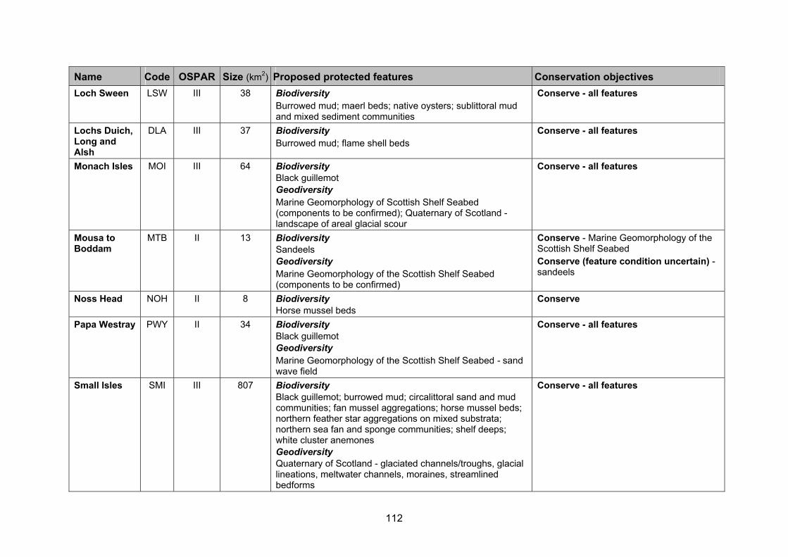
112
Name Code OSPAR Size (km2) Proposed protected features Conservation objectives
Loch Sween LSW III 38 Biodiversity Burrowed mud; maerl beds; native oysters; sublittoral mud and mixed sediment communities
Conserve - all features
Lochs Duich, Long and Alsh
DLA III 37 Biodiversity Burrowed mud; flame shell beds
Conserve - all features
Monach Isles MOI III 64 Biodiversity Black guillemot Geodiversity Marine Geomorphology of Scottish Shelf Seabed (components to be confirmed); Quaternary of Scotland - landscape of areal glacial scour
Conserve - all features
Mousa to Boddam
MTB II 13 Biodiversity Sandeels Geodiversity Marine Geomorphology of the Scottish Shelf Seabed (components to be confirmed)
Conserve - Marine Geomorphology of the Scottish Shelf Seabed Conserve (feature condition uncertain) - sandeels
Noss Head NOH II 8 Biodiversity Horse mussel beds
Conserve
Papa Westray PWY II 34 Biodiversity Black guillemot Geodiversity Marine Geomorphology of the Scottish Shelf Seabed - sand wave field
Conserve - all features
Small Isles SMI III 807 Biodiversity Black guillemot; burrowed mud; circalittoral sand and mud communities; fan mussel aggregations; horse mussel beds; northern feather star aggregations on mixed substrata; northern sea fan and sponge communities; shelf deeps; white cluster anemones Geodiversity Quaternary of Scotland - glaciated channels/troughs, glacial lineations, meltwater channels, moraines, streamlined bedforms
Conserve - all features

113
Name Code OSPAR Size (km2) Proposed protected features Conservation objectives
South Arran ARR III 277 Biodiversity Burrowed mud; herring spawning grounds; kelp and seaweed communities on sublittoral sediment; maerl beds; maerl or coarse shell gravel with burrowing sea cucumbers; ocean quahog (species); seagrass beds; shallow tide-swept coarse sands with burrowing bivalves
Conserve - kelp and seaweed communities on sublittoral sediments; seagrass beds Conserve (feature condition uncertain) - burrowed mud; herring spawning grounds; maerl or coarse shell gravel with burrowing sea cucumbers; shallow tide-swept coarse sands with burrowing bivalves; ocean quahog Recover - maerl beds
Upper Loch Fyne and Loch Goil
LFG III 87 Biodiversity Burrowed mud; flame shell beds; horse mussel beds; ocean quahog (species); sublittoral mud and specific mixed sediment communities
Conserve (feature condition uncertain) - burrowed mud; horse mussel beds; ocean quahog (species); sublittoral mud and mixed sediment communities Recover - flame shell beds
Wester Ross60 WER III 601 Biodiversity Burrowed mud; circalittoral muddy sand communities; flame shell beds; kelp and seaweed communities on sublittoral sediment; maerl beds; maerl or coarse shell gravel with burrowing sea cucumbers; northern feather star aggregations on mixed substrata Geodiversity Marine Geomorphology of the Scottish Shelf Seabed - banks of unknown substrate; Quaternary of Scotland - glaciated channels/troughs, megascale glacial lineations, moraines; Seabed Fluid and Gas Seep - pockmarks; Submarine Mass Movement - slide scars
Conserve - burrowed mud; circalittoral muddy sand communities; kelp and seaweed communities on sublittoral sediment; northern feather star aggregations on mixed substrata; all geodiversity features Conserve (feature condition uncertain) - maerl or coarse shell gravel with burrowing sea cucumbers Recover - flame shell beds; maerl beds
Wyre and Rousay Sounds
WYR II 16 Biodiversity Kelp and seaweed communities on sublittoral sediment; maerl beds Geodiversity Marine Geomorphology of the Scottish Shelf Seabed (components to be confirmed)
Conserve - all features
60 Formerly the North-west sea lochs and Summer Isles pMPA.

114
Figure A5.1. Possible Nature Conservation MPAs recommended for designation in nearshore waters off the north-east coast of Scotland and in Orkney waters. This map shows the North-west Orkney pMPA (straddles the 12 nm administrative boundary) which is the subject of separate advice from JNCC to Marine Scotland.

115
Figure A5.2. Possible Nature Conservation MPAs recommended for designation in the waters around Shetland.

116
Figure A5.3. Possible Nature Conservation MPAs recommended for designation in nearshore waters around the Inner and Outer Hebrides on the west coast of Scotland.
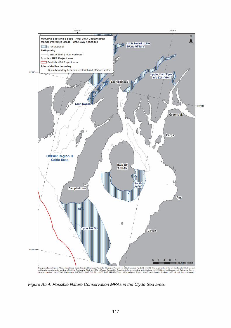
117
Figure A5.4. Possible Nature Conservation MPAs in the Clyde Sea area.

www.snh.gov.uk© Scottish Natural Heritage 2014 ISBN: 978-1-78391-143-1
Policy and Advice Directorate, Great Glen House,Leachkin Road, Inverness IV3 8NWT: 01463 725000
You can download a copy of this publication from the SNH website.