snake river - usgs
TRANSCRIPT

197
Figure 18. Schematic diagram showing gaging stations in Snake River Basinbetween Idaho Falls and Snake River at Neeley.
Idaho Power
Blackfoot River068495
0660
Spring Creek
Marsh Creek
0625
Bypass
Bannock Creek
0755
0685
Ririe Lake100,000 acre-feet
Storage began 1975
div
ersi
on
Portneuf River
Ross Fork
0600
SN
AK
E
RIV
ER
0580
Willow Creek
0730
075983
0695
057155
UpperIdaho Falls
Middle andLower
Idaho Falls
Gem
Willow Creek
American Falls Reservoir1,700,000 acre-feetStorage began 1926
Sand
C
reek
FloodwayChannel
058510
Sand
C
reek
Blackfoot Reservoir413,000 acre-feet
Storage began 1910
057940
Grays LakeDiversions
began 1924
058520
058530
058529
0630
0750
0770
0685
EXPLANATION
Streamflow gaging station
Stream, showing direction of flow
Canal, showing direction of flow
Powerhouse
Portneuf Reservoir
Willow Cr.
075910
057132
0575

198WILLOW CREEK BASIN
13057500 GRAYS LAKE OUTLET NEAR HERMAN, ID
LOCATION.--Lat 43°08'05", long 111°29'42"(revised), (NAD83), in NW1⁄4NE1⁄4NE1⁄4 sec.26, T.3 S., R.42 E., Bonneville County,Herman quad., Hydrologic Unit 17040205, on right bank 200 ft upstream from road crossing, 3.5 mi west of Herman, and 8 mi upstreamfrom Brockman Creek.
DRAINAGE AREA.-- 137 mi2.
PERIOD OF RECORD.--1916-25 (irrigation seasons only), June 1966 to October 1970, June 2002 to current year (irrigationseason only).
REVISED RECORDS.--WDR-ID-1969: 1967.
GAGE.--Water-stage recorder. Elevation of gage is 6,384 ft, from topographic map. Prior to Oct. 18, 1917, non-recording gage, andOct. 18, 1917 to Sept. 30, 1925, water-stage recorder at site 2 mi downstream at different datum.
REMARKS.--Records fair.
EXTREMES FOR PERIOD OF RECORD.--Maximum discharge observed, 1,350 ft3⁄s May 15, 1917, gage height 5.9 ft (site and datumthen in use); no flow Apr. 25, 1917.
EXTREMES FOR CURRENT YEAR.--Maximum daily discharge, 4.3 ft3⁄s Apr. 17; minimum daily, 0.07 ft3⁄s Apr. 1.
Discharge, cubic feet per secondWATER YEAR OCTOBER 2004 TO SEPTEMBER 2005
DAILY MEAN VALUES
DAY OCT NOV DEC JAN FEB MAR APR MAY JUN JUL AUG SEP
1 --- --- --- --- --- --- 0.07 0.45 1.2 0.38 0.31 0.28 2 --- --- --- --- --- --- 0.08 0.43 1.0 0.38 0.39 0.28 3 --- --- --- --- --- --- 0.11 0.59 1.00 0.38 0.48 0.28 4 --- --- --- --- --- --- 0.11 0.80 1.1 0.40 0.53 0.28 5 --- --- --- --- --- --- 0.09 0.65 1.1 0.34 0.43 0.26
6 --- --- --- --- --- --- 0.09 0.63 1.7 0.31 0.29 0.27 7 --- --- --- --- --- --- 0.10 1.1 1.3 0.29 0.40 0.32 8 --- --- --- --- --- --- 0.10 0.84 1.1 0.30 0.34 0.52 9 --- --- --- --- --- --- 0.09 0.87 1.1 0.34 0.27 0.50 10 --- --- --- --- --- --- 0.10 0.91 0.94 0.42 0.26 0.54
11 --- --- --- --- --- --- 0.12 0.99 0.86 0.39 0.25 0.54 12 --- --- --- --- --- --- 0.22 0.97 1.3 0.32 0.24 0.62 13 --- --- --- --- --- --- 0.28 0.85 1.0 0.27 0.24 0.61 14 --- --- --- --- --- --- 0.20 0.69 0.90 0.25 0.22 0.52 15 --- --- --- --- --- --- 0.20 0.71 0.83 0.24 0.22 0.53
16 --- --- --- --- --- --- 0.45 0.90 0.79 0.24 0.29 0.45 17 --- --- --- --- --- --- 4.3 0.99 0.78 0.25 0.32 0.41 18 --- --- --- --- --- --- 2.1 0.76 0.78 0.24 0.55 0.40 19 --- --- --- --- --- --- 0.87 0.80 0.75 0.23 0.51 0.32 20 --- --- --- --- --- --- 0.74 0.76 0.73 0.22 0.29 0.28
21 --- --- --- --- --- --- 0.52 0.76 0.72 0.21 0.26 0.30 22 --- --- --- --- --- --- 0.61 0.76 0.65 0.22 0.27 0.30 23 --- --- --- --- --- --- 0.89 0.86 0.64 0.27 0.26 0.30 24 --- --- --- --- --- --- 1.2 0.74 0.58 0.31 0.25 0.45 25 --- --- --- --- --- --- 0.87 0.68 0.64 0.29 0.24 0.43
26 --- --- --- --- --- --- 2.2 0.75 0.69 0.24 0.23 0.36 27 --- --- --- --- --- --- 0.77 0.78 0.60 0.24 0.24 0.31 28 --- --- --- --- --- --- 0.78 0.77 0.52 0.23 0.26 0.28 29 --- --- --- --- --- --- 0.53 0.86 0.49 0.26 0.28 0.27 30 --- --- --- --- --- --- 0.51 0.95 0.44 0.27 0.27 0.26 31 --- --- --- --- --- --- --- 0.94 --- 0.28 0.27 ---
TOTAL --- --- --- --- --- --- 19.30 24.54 26.23 9.01 9.66 11.47 MEAN --- --- --- --- --- --- 0.64 0.79 0.87 0.29 0.31 0.38 MAX --- --- --- --- --- --- 4.3 1.1 1.7 0.42 0.55 0.62 MIN --- --- --- --- --- --- 0.07 0.43 0.44 0.21 0.22 0.26 AC-FT --- --- --- --- --- --- 38 49 52 18 19 23

199WILLOW CREEK BASIN
13057940 WILLOW CREEK BELOW TEX CREEK, NEAR RIRIE, ID
LOCATION.--Lat 43°26'31", long 111°43'42"(revised), (NAD83), in NE1⁄4SE1⁄4 sec.3, T.1 N., R.40 E., Bonneville County, Lone PineRidge quad., Hydrologic Unit 17040205, on right bank, 0.3 mi below Tex Creek and 13.2 mi southeast of Ririe.
DRAINAGE AREA.--568 mi2.
PERIOD OF RECORD.--August 1977 to September 1979, October 1985 to current year.
GAGE.--Water-stage recorder. Elevation of gage is 5,200 ft above NGVD of 1929, from topographic map.
REMARKS.--Records good except for estimated daily discharges, which are fair. Station equipment includes satellite telemetry.Diversions above station for irrigation of about 7,300 acres, of which 100 acres are irrigated by withdrawals from ground water(1966 determination). Since May 1924, water has been diverted from Grays Lake into Meadow Creek basin and thence intoBlackfoot Reservoir.
EXTREMES FOR PERIOD OF RECORD.--Maximum discharge, 2,420 ft3⁄s May 7, 1997, gage height, 6.73 ft; minimum, 2.1 ft3⁄sAug. 23, 1992, gage height, 1.62 ft.
EXTREMES FOR CURRENT YEAR.--Maximum discharge, 585 ft3⁄s Apr. 26, gage height, 4.39 ft; minimum, 12 ft3⁄s Aug. 30,gage height, 2.01 ft.
Discharge, cubic feet per secondWATER YEAR OCTOBER 2004 TO SEPTEMBER 2005
DAILY MEAN VALUES
DAY OCT NOV DEC JAN FEB MAR APR MAY JUN JUL AUG SEP
1 25 e28 e20 e25 e22 e30 44 228 201 72 23 14 2 24 e25 e21 e24 e20 e28 44 208 228 66 21 15 3 21 e26 e20 e24 e20 e28 48 200 192 60 21 15 4 20 e28 e19 e22 e20 e30 66 246 176 57 21 14 5 19 e27 e20 e20 e23 e28 70 280 165 51 19 14
6 19 e26 e21 e22 e22 e27 63 257 216 48 16 14 7 19 e26 e22 e22 e27 e29 69 262 278 45 16 15 8 19 e27 e23 e23 e26 e30 84 436 240 43 17 14 9 19 e28 24 23 e28 e34 86 397 211 40 16 14 10 19 29 27 e24 e25 e34 77 382 191 41 16 14
11 20 30 31 e23 e20 e32 75 392 173 43 14 16 12 20 31 36 e21 e24 e32 85 402 197 39 14 19 13 19 30 e34 e22 e28 e30 122 394 249 35 14 20 14 19 29 e35 e20 e28 e28 181 336 203 32 14 21 15 20 27 e31 e18 e18 e33 226 297 170 30 14 20
16 20 28 e28 e23 e15 e36 206 297 150 28 14 19 17 19 28 e30 e26 e16 e38 216 385 140 27 18 19 18 21 e26 e25 26 e19 e35 288 439 130 26 28 21 19 23 e25 e26 27 e24 e38 265 378 124 24 30 22 20 27 e24 e27 e26 e28 44 240 362 115 24 25 20
21 33 e23 e25 e24 e27 45 269 333 98 23 21 21 22 43 e24 e23 e22 e24 45 241 302 98 22 21 24 23 41 e25 e19 e23 e18 50 285 281 95 22 17 26 24 46 e25 e22 e22 e19 60 345 261 94 24 16 26 25 42 e26 e23 e20 e20 50 386 242 90 24 17 32
26 36 e24 e22 e22 e22 48 469 226 85 22 16 30 27 32 e22 e24 e24 e24 45 439 213 84 20 16 29 28 32 e20 25 27 e25 45 377 201 81 20 15 26 29 37 e18 25 27 --- 50 334 195 79 19 14 25 30 38 e16 26 27 --- 50 264 208 74 21 13 24 31 38 --- e25 e24 --- 43 --- 197 --- 24 14 ---
TOTAL 830 771 779 723 632 1175 5964 9237 4627 1072 551 603 MEAN 26.8 25.7 25.1 23.3 22.6 37.9 199 298 154 34.6 17.8 20.1 MAX 46 31 36 27 28 60 469 439 278 72 30 32 MIN 19 16 19 18 15 27 44 195 74 19 13 14 AC-FT 1650 1530 1550 1430 1250 2330 11830 18320 9180 2130 1090 1200
STATISTICS OF MONTHLY MEAN DATA FOR WATER YEARS 1977 - 2005, BY WATER YEAR (WY)
MEAN 35.5 39.6 38.3 38.3 40.5 83.1 312 397 160 55.0 31.2 28.0 MAX 73.6 80.0 67.7 101 65.1 264 867 1427 409 148 93.1 72.7 (WY) 1987 1999 1999 1997 1986 1986 1986 1997 1999 1997 1997 1997 MIN 10.5 14.9 15.7 18.5 17.2 26.1 63.5 25.3 15.2 6.34 3.16 7.38 (WY) 1993 2004 2004 2003 2004 2002 1992 1992 1992 2003 1992 1992
SUMMARY STATISTICS FOR 2004 CALENDAR YEAR FOR 2005 WATER YEAR WATER YEARS 1977 - 2005
ANNUAL TOTAL 19548.5 26964 ANNUAL MEAN 53.4 73.9 105 HIGHEST ANNUAL MEAN 287 1997 LOWEST ANNUAL MEAN 27.4 1992 HIGHEST DAILY MEAN 440 Apr 9 469 Apr 26 2210 May 7 1997 LOWEST DAILY MEAN 9.2 Aug 12 13 Aug 30 2.4 Aug 22 1992 ANNUAL SEVEN-DAY MINIMUM 9.5 Aug 9 14 Aug 29 2.7 Aug 18 1992 ANNUAL RUNOFF (AC-FT) 38770 53480 76120 10 PERCENT EXCEEDS 138 240 243 50 PERCENT EXCEEDS 24 27 45 90 PERCENT EXCEEDS 13 18 15
e Estimated

200WILLOW CREEK BASIN
13058000 WILLOW CREEK NEAR RIRIE, ID
LOCATION.--Lat 43°35'00", long 111°44'46"(revised), (NAD83), in SE1⁄4SE1⁄4 sec.16, T.3 N., R.40 E., Bonneville County, Poplar quad.,Hydrologic Unit 17040205, on right bank 0.25 mi downstream from Ririe Dam, 3.4 mi southeast of Ririe, and at mile 20.2.
DRAINAGE AREA.--627 mi2.
PERIOD OF RECORD.--April 1903 to September 1904, October 1916 to September 1925, May to August 1928, October 1962 toSeptember 1979, October 1985 to current year. Monthly discharge only for some periods, published in WSP 1317.
GAGE.--Water-stage recorder. Elevation of gage is 4,950 ft above NGVD of 1929, from topographic map. Prior to September 1904,nonrecording gage at site about 3.25 mi downstream at different datum. October 1916 to June 1921, nonrecording gage, June 1921 toAugust 1928, water-stage recorder at present site. October 1962 to September 1979, at site 1.75 mi downstream at different datum.Records comparable.
REMARKS.--No estimated daily discharges. Records good. Diversions above station for irrigation of about 7,300 acres, of which about100 acres are irrigated by withdrawals from ground water (1966 determination). Since May 1924, water has been diverted from GraysLake some years, about 40 mi upstream, into Meadow Creek basin and thence into Blackfoot Reservoir. Flow regulated by RirieReservoir beginning December 1975, with some storage beginning July 1974. During winter months when gates at Ririe Dam areclosed, seepage may pass the gage, but sinks into the gravels; consequently this flow is not published.
EXTREMES FOR PERIOD OF RECORD.--Maximum discharge observed (1903-74), 4,200 ft3⁄s May 15, 1917, gage height, 16.30 ft;minimum daily, 1.2 ft3⁄s Aug. 12, 1974.
Maximum discharge since regulation began in 1975, 2,320 ft3⁄s May 20, 1975, gage height, 14.07 ft; no flow for long periodsmost years.
EXTREMES OUTSIDE PERIOD OF RECORD.--Maximum discharge since 1899, 5,080 ft3⁄s Feb. 11, 1962, from estimate based onfield survey, gage height, 15.0 ft from floodmarks; stream reported practically dry during summers of 1899 and 1934.
EXTREMES FOR CURRENT YEAR.--Maximum daily discharge, 194 ft3⁄s Sept. 21-24; no flow for long periods.
Discharge, cubic feet per secondWATER YEAR OCTOBER 2004 TO SEPTEMBER 2005
DAILY MEAN VALUES
DAY OCT NOV DEC JAN FEB MAR APR MAY JUN JUL AUG SEP
1 21 0.00 0.00 0.00 0.00 0.00 0.00 105 117 91 27 26 2 20 0.00 0.00 0.00 0.00 0.00 0.00 105 117 92 27 26 3 20 0.00 0.00 0.00 0.00 0.00 0.00 105 117 91 27 26 4 20 0.00 0.00 0.00 0.00 0.00 0.00 105 117 91 27 26 5 20 0.00 0.00 0.00 0.00 0.00 0.00 106 117 69 27 27
6 20 0.00 0.00 0.00 0.00 0.00 0.00 106 118 54 27 27 7 20 0.00 0.00 0.00 0.00 0.00 0.00 106 118 54 26 27 8 20 0.00 0.00 0.00 0.00 0.00 0.00 106 118 54 26 27 9 19 0.00 0.00 0.00 0.00 0.00 0.00 107 118 54 26 26 10 19 0.00 0.00 0.00 0.00 0.00 0.00 107 118 54 26 26
11 19 0.00 0.00 0.00 0.00 0.00 0.00 107 118 54 26 26 12 10 0.00 0.00 0.00 0.00 0.00 0.00 107 118 43 26 26 13 0.00 0.00 0.00 0.00 0.00 0.00 0.00 108 118 38 26 27 14 0.00 0.00 0.00 0.00 0.00 0.00 0.00 108 118 38 26 28 15 0.00 0.00 0.00 0.00 0.00 0.00 0.00 109 118 38 26 28
16 0.00 0.00 0.00 0.00 0.00 0.00 0.00 110 118 38 26 28 17 0.00 0.00 0.00 0.00 0.00 0.00 0.00 111 118 37 26 28 18 0.00 0.00 0.00 0.00 0.00 0.00 0.00 111 118 31 26 28 19 0.00 0.00 0.00 0.00 0.00 0.00 0.00 112 118 28 26 66 20 0.00 0.00 0.00 0.00 0.00 0.00 0.00 112 118 28 26 144
21 0.00 0.00 0.00 0.00 0.00 0.00 0.00 113 107 28 26 194 22 0.00 0.00 0.00 0.00 0.00 0.00 0.00 113 103 28 26 194 23 0.00 0.00 0.00 0.00 0.00 0.00 0.00 114 103 28 26 194 24 0.00 0.00 0.00 0.00 0.00 0.00 0.00 115 103 28 26 194 25 0.00 0.00 0.00 0.00 0.00 0.00 0.00 115 102 28 26 193
26 0.00 0.00 0.00 0.00 0.00 0.00 72 115 102 28 26 192 27 0.00 0.00 0.00 0.00 0.00 0.00 105 115 96 28 26 192 28 0.00 0.00 0.00 0.00 0.00 0.00 105 116 91 28 26 191 29 0.00 0.00 0.00 0.00 --- 0.00 105 116 91 27 26 191 30 0.00 0.00 0.00 0.00 --- 0.00 105 116 91 27 26 191 31 0.00 --- 0.00 0.00 --- 0.00 --- 117 --- 27 26 ---
TOTAL 228.00 0.00 0.00 0.00 0.00 0.00 492.00 3418 3344 1382 812 2619 MEAN 7.35 0.00 0.00 0.00 0.00 0.00 16.4 110 111 44.6 26.2 87.3 MAX 21 0.00 0.00 0.00 0.00 0.00 105 117 118 92 27 194 MIN 0.00 0.00 0.00 0.00 0.00 0.00 0.00 105 91 27 26 26 AC-FT 452 0.00 0.00 0.00 0.00 0.00 976 6780 6630 2740 1610 5190

201WILLOW CREEK BASIN
13058000 WILLOW CREEK NEAR RIRIE, ID--Continued
STATISTICS OF MONTHLY MEAN DATA FOR WATER YEARS 1903 - 1974, BY WATER YEAR (WY) (UNREGULATED)
OCT NOV DEC JAN FEB MAR APR MAY JUN JUL AUG SEP
MEAN 50.0 53.6 49.0 58.5 64.3 102 401 851 358 111 48.4 42.3 MAX 92.6 81.4 91.6 160 155 274 750 2133 1325 313 117 73.1 (WY) 1973 1973 1965 1969 1963 1972 1919 1917 1917 1917 1917 1917 MIN 20.5 30.4 25.3 25.4 35.0 35.5 124 234 85.9 35.3 12.5 16.6 (WY) 1964 1967 1970 1963 1904 1964 1970 1966 1924 1919 1966 1924
SUMMARY STATISTICS a WATER YEARS 1903 - 1974
ANNUAL MEAN 176 HIGHEST ANNUAL MEAN 280 1971 LOWEST ANNUAL MEAN 88.0 1963 HIGHEST DAILY MEAN 4200 May 15 1917 LOWEST DAILY MEAN 1.2 Aug 12 1974 ANNUAL SEVEN-DAY MINIMUM 4.3 Aug 7 1974 ANNUAL RUNOFF (AC-FT) 127700 10 PERCENT EXCEEDS 546 50 PERCENT EXCEEDS 66 90 PERCENT EXCEEDS 32
STATISTICS OF MONTHLY MEAN DATA FOR WATER YEARS 1975 - 2005, BY WATER YEAR (WY) (REGULATED)
OCT NOV DEC JAN FEB MAR APR MAY JUN JUL AUG SEP
MEAN 168 54.1 11.2 4.91 10.0 34.6 73.2 289 184 80.2 139 239 MAX 443 223 116 51.9 67.5 360 434 1360 824 340 670 610 (WY) 1998 1999 1996 1975 1978 1986 1976 1997 1975 1976 1994 1993 MIN 0.00 0.00 0.00 0.00 0.00 0.00 0.00 29.5 30.4 23.5 25.1 17.7 (WY) 2002 1992 1986 1986 1987 1987 1988 1977 2001 2003 1977 1977
SUMMARY STATISTICS FOR 2004 CALENDAR YEAR FOR 2005 WATER YEAR b WATER YEARS 1975 - 2005
ANNUAL TOTAL 17988.00 12295.00 ANNUAL MEAN 49.1 33.7 108 HIGHEST ANNUAL MEAN 295 1997 LOWEST ANNUAL MEAN 32.4 2002 HIGHEST DAILY MEAN 385 Aug 24 194 Sep 21 2290 May 20 1975 LOWEST DAILY MEAN 0.00 Jan 1 0.00 Oct 13 0.00 Nov 22 1985 ANNUAL SEVEN-DAY MINIMUM 0.00 Jan 1 0.00 Oct 13 0.00 Nov 22 1985 ANNUAL RUNOFF (AC-FT) 35680 24390 77980 10 PERCENT EXCEEDS 110 115 369 50 PERCENT EXCEEDS 0.00 0.00 32 90 PERCENT EXCEEDS 0.00 0.00 0.00
a Unregulated b Regulated

202WILLOW CREEK BASIN
13058510 SAND CREEK ABOVE WILLOW CREEK DIVERSION, NEAR UCON, ID
LOCATION.--Lat 43°34'27", long 111°53'42", (NAD83), in NE1⁄4SW1⁄4 sec.20, T.3 N., R.39 E., Bonneville County, Ucon quad.,Hydrologic Unit 17040201, on right bank about 300 ft downstream from Sand Creek control gates, about 0.6 mi east of U.S.Highway 26 crossing with Willow Creek, and 3.3 mi southeast of Ucon.
PERIOD OF RECORD.--March 1978 to September 1979, October 1985 to current year.
GAGE.--Water-stage recorder. Elevation of gage is 4,850 ft above NGVD of 1929, from topographic map.
REMARKS.--No estimated daily discharges. Records fair. Station equipment includes satellite telemetry. Flow controlled by headgates.Water is diverted during the irrigation season from the Snake River through Eagle Rock Canal to Willow Creek 5.5 mi upstream fromthe station. Diversions below Ririe Lake (13057950) and above station for irrigation of about 1,500 acres.
EXTREMES FOR PERIOD OF RECORD.--Maximum daily discharge, 797 ft3⁄s June 13, 1996; no flow for long periods.
Discharge, cubic feet per secondWATER YEAR OCTOBER 2004 TO SEPTEMBER 2005
DAILY MEAN VALUES
DAY OCT NOV DEC JAN FEB MAR APR MAY JUN JUL AUG SEP
1 225 0.00 0.00 0.00 0.00 0.00 0.00 149 409 504 416 414 2 220 0.00 0.00 0.00 0.00 0.00 0.00 142 435 499 399 396 3 228 0.00 0.00 0.00 0.00 0.00 0.00 194 422 527 397 357 4 234 0.00 0.00 0.00 0.00 0.00 0.00 258 406 565 388 373 5 230 0.00 0.00 0.00 0.00 0.00 0.00 184 391 540 383 364
6 242 0.00 0.00 0.00 0.00 0.00 0.00 184 422 504 362 367 7 234 0.00 0.00 0.00 0.00 0.00 0.00 201 422 522 358 348 8 230 0.00 0.00 0.00 0.00 0.00 0.00 211 379 538 358 329 9 243 0.00 0.00 0.00 0.00 0.00 0.00 182 356 544 329 346 10 241 0.00 0.00 0.00 0.00 0.00 0.00 239 330 559 332 341
11 233 0.00 0.00 0.00 0.00 0.00 0.00 235 354 555 321 358 12 225 0.00 0.00 0.00 0.00 0.00 0.00 225 397 552 332 353 13 219 0.00 0.00 0.00 0.00 0.00 0.00 211 415 562 327 321 14 230 0.00 0.00 0.00 0.00 0.00 0.00 197 429 566 332 328 15 228 0.00 0.00 0.00 0.00 0.00 0.00 193 452 556 337 331
16 200 0.00 0.00 0.00 0.00 0.00 0.00 209 439 551 345 332 17 183 0.00 0.00 0.00 0.00 0.00 0.00 251 377 543 329 347 18 189 0.00 0.00 0.00 0.00 0.00 0.00 235 366 528 302 338 19 189 0.00 0.00 0.00 0.00 0.00 0.00 215 408 499 296 286 20 179 0.00 0.00 0.00 0.00 0.00 0.00 207 427 510 300 293
21 157 0.00 0.00 0.00 0.00 0.00 0.00 214 481 498 312 319 22 151 0.00 0.00 0.00 0.00 0.00 0.00 190 507 494 319 301 23 158 0.00 0.00 0.00 0.00 0.00 0.00 183 513 462 302 297 24 153 0.00 0.00 0.00 0.00 0.00 0.00 191 521 453 342 297 25 145 0.00 0.00 0.00 0.00 0.00 0.00 241 513 471 368 276
26 144 0.00 0.00 0.00 0.00 0.00 59 262 527 441 395 255 27 142 0.00 0.00 0.00 0.00 0.00 130 272 501 439 386 247 28 146 0.00 0.00 0.00 0.00 0.00 133 305 491 448 393 240 29 108 0.00 0.00 0.00 --- 0.00 143 347 505 435 397 239 30 2.3 0.00 0.00 0.00 --- 0.00 135 360 499 406 393 232 31 0.00 --- 0.00 0.00 --- 0.00 --- 353 --- 417 406 ---
TOTAL 5708.30 0.00 0.00 0.00 0.00 0.00 600.00 7040 13094 15688 10956 9625 MEAN 184 0.00 0.00 0.00 0.00 0.00 20.0 227 436 506 353 321 MAX 243 0.00 0.00 0.00 0.00 0.00 143 360 527 566 416 414 MIN 0.00 0.00 0.00 0.00 0.00 0.00 0.00 142 330 406 296 232 AC-FT 11320 0.00 0.00 0.00 0.00 0.00 1190 13960 25970 31120 21730 19090
CAL YR 2004 TOTAL 62412.24 MEAN 171 MAX 516 MIN 0.00 AC-FT 123800 WTR YR 2005 TOTAL 62711.30 MEAN 172 MAX 566 MIN 0.00 AC-FT 124400

203WILLOW CREEK BASIN
13058520 WILLOW CREEK FLOODWAY CHANNEL NEAR UCON, ID
LOCATION.--Lat 43°34'35", long 111°54'47", (NAD83), in SW1⁄4NE1⁄4 sec.19, T.3 N., R.39 E., Bonneville County, Ucon quad.,Hydrologic Unit 17040201, on right bank 300 ft below Willow Creek floodway channel diversion structure, 2 mi southeast of Ucon.
PERIOD OF RECORD.--April 1978 to September 1979, October 1985 to current year.
GAGE.--Water-stage recorder. Elevation of gage is 4,840 ft above NGVD of 1929, from topographic map.
REMARKS.--No estimated daily discharges. Records fair. Station equipment includes satellite telemetry. Flow controlled by headgates.Floodway channel built to carry excess flow from Willow Creek and Sand Creek during periods of flooding.
EXTREMES FOR PERIOD OF RECORD.--Maximum daily discharge, 1,030 ft3⁄s Feb. 11, 1979; no flow for long periods.
Discharge, cubic feet per secondWATER YEAR OCTOBER 2004 TO SEPTEMBER 2005
DAILY MEAN VALUES
DAY OCT NOV DEC JAN FEB MAR APR MAY JUN JUL AUG SEP
1 0.00 0.00 0.00 0.00 0.00 0.00 0.00 0.00 0.00 0.48 0.00 0.00 2 0.00 0.00 0.00 0.00 0.00 0.00 0.00 0.00 0.11 0.50 0.00 0.00 3 0.00 0.00 0.00 0.00 0.00 0.00 0.00 0.00 0.00 0.06 0.00 0.00 4 0.00 0.00 0.00 0.00 0.00 0.00 0.00 0.00 0.00 0.00 0.00 0.00 5 0.00 0.00 0.00 0.00 0.00 0.00 0.00 0.00 0.00 0.00 0.00 0.00
6 0.00 0.00 0.00 0.00 0.00 0.00 0.00 0.00 0.00 0.35 0.00 0.00 7 0.00 0.00 0.00 0.00 0.00 0.00 0.00 0.00 0.00 0.05 0.00 0.00 8 0.00 0.00 0.00 0.00 0.00 0.00 0.00 0.00 0.00 0.00 0.00 0.00 9 0.00 0.00 0.00 0.00 0.00 0.00 0.00 0.00 0.00 0.00 0.00 0.00 10 0.00 0.00 0.00 0.00 0.00 0.00 0.00 0.03 0.00 0.00 0.00 0.00
11 0.00 0.00 0.00 0.00 0.00 0.00 0.00 0.00 0.00 0.00 0.00 0.00 12 0.00 0.00 0.00 0.00 0.00 0.00 0.00 0.00 0.00 0.16 0.00 0.00 13 0.00 0.00 0.00 0.00 0.00 0.00 0.00 0.00 0.00 0.00 0.00 0.00 14 0.00 0.00 0.00 0.00 0.00 0.00 0.00 0.00 0.00 0.00 0.00 0.00 15 0.00 0.00 0.00 0.00 0.00 0.00 0.00 0.00 0.00 0.00 0.00 0.00
16 0.00 0.00 0.00 0.00 0.00 0.00 0.00 0.00 0.00 0.00 0.00 0.00 17 0.00 0.00 0.00 0.00 0.00 0.00 0.00 0.00 0.00 0.00 0.00 0.00 18 0.00 0.00 0.00 0.00 0.00 0.00 0.00 0.00 0.00 0.00 0.00 0.00 19 0.00 0.00 0.00 0.00 0.00 0.00 0.00 0.00 0.00 0.00 0.00 0.25 20 0.00 0.00 0.00 0.00 0.00 0.00 0.00 0.00 0.00 0.00 0.00 60
21 0.00 0.00 0.00 0.00 0.00 0.00 0.00 0.00 0.00 0.00 0.00 175 22 0.00 0.00 0.00 0.00 0.00 0.00 0.00 0.00 0.00 0.00 0.00 183 23 0.00 0.00 0.00 0.00 0.00 0.00 0.00 0.00 0.67 0.00 0.00 171 24 0.00 0.00 0.00 0.00 0.00 0.00 0.00 0.00 0.81 0.00 0.00 179 25 0.00 0.00 0.00 0.00 0.00 0.00 0.00 0.00 0.74 0.00 0.00 204
26 0.00 0.00 0.00 0.00 0.00 0.00 7.2 0.00 0.44 0.00 0.00 226 27 0.00 0.00 0.00 0.00 0.00 0.00 40 0.00 0.69 0.00 0.00 208 28 0.00 0.00 0.00 0.00 0.00 0.00 18 0.00 0.63 0.00 0.00 204 29 0.00 0.00 0.00 0.00 --- 0.00 0.00 0.00 0.64 0.00 0.00 196 30 0.00 0.00 0.00 0.00 --- 0.00 0.00 0.00 0.19 0.00 0.00 203 31 0.00 --- 0.00 0.00 --- 0.00 --- 0.00 --- 0.00 0.00 ---
TOTAL 0.00 0.00 0.00 0.00 0.00 0.00 65.20 0.03 4.92 1.60 0.00 2009.25 MEAN 0.00 0.00 0.00 0.00 0.00 0.00 2.17 0.00 0.16 0.05 0.00 67.0 MAX 0.00 0.00 0.00 0.00 0.00 0.00 40 0.03 0.81 0.50 0.00 226 MIN 0.00 0.00 0.00 0.00 0.00 0.00 0.00 0.00 0.00 0.00 0.00 0.00 AC-FT 0.00 0.00 0.00 0.00 0.00 0.00 129 0.06 9.8 3.2 0.00 3990
CAL YR 2004 TOTAL 7287.67 MEAN 19.9 MAX 350 MIN 0.00 AC-FT 14460 WTR YR 2005 TOTAL 2081.00 MEAN 5.70 MAX 226 MIN 0.00 AC-FT 4130

204WILLOW CREEK BASIN
13058529 WILLOW CREEK FLOODWAY CHANNEL AT MOUTH NEAR IDAHO FALLS, ID
LOCATION.--Lat 43°34'29", long 112°02'53", (NAD83), in NE1⁄4 NW1⁄4 SE1⁄4 sec.24, T.3 N., R.37 E., Bonneville County, Idaho FallsNorth quad., Hydrologic Unit 17040201, on left bank 80 ft upstream from mouth, and 4.5 mi north of Idaho Falls.
PERIOD OF RECORD.--October 1987 to current year. Published 1988-91 as station number 13058549.
GAGE.--Water-stage recorder. Elevation of gage is 4,745 ft above NGVD of 1929, from topographic map. October 1987 to April 14, 1988at datum 10.00 ft higher.
REMARKS.--Records good except for estimated daily discharges, which are fair. Station equipment includes satellite telemetry. Flowcontrolled by headgates. Floodway channel built to carry excess flow from Willow Creek and Sand Creek during periods of flooding.
EXTREMES FOR PERIOD OF RECORD.--Maximum daily discharge, 913 ft3⁄s May 11, 1997; no flow for long periods.
Discharge, cubic feet per secondWATER YEAR OCTOBER 2004 TO SEPTEMBER 2005
DAILY MEAN VALUES
DAY OCT NOV DEC JAN FEB MAR APR MAY JUN JUL AUG SEP
1 4.3 0.00 0.00 0.00 0.00 0.00 0.00 1.6 2.7 0.00 0.00 0.84 2 4.9 0.00 0.00 0.00 0.00 0.00 0.00 0.00 5.7 0.00 0.00 0.00 3 4.1 0.00 0.00 0.00 0.00 0.00 0.00 0.00 6.8 0.00 0.00 0.00 4 3.1 0.00 0.00 0.00 0.00 0.00 0.00 1.2 21 0.00 0.00 0.00 5 2.6 0.00 0.00 0.00 0.00 0.00 0.00 7.1 18 1.7 0.19 0.00
6 2.7 0.00 0.00 0.00 0.00 0.00 0.00 2.6 26 0.00 0.00 0.00 7 8.9 0.00 0.00 0.00 0.00 0.00 0.00 0.00 39 0.00 1.7 1.7 8 8.7 0.00 0.00 0.00 0.00 0.00 0.00 0.00 42 0.00 1.1 4.2 9 4.8 0.00 0.00 0.00 0.00 0.00 0.00 1.1 46 0.00 2.4 4.1 10 1.7 0.00 0.00 0.00 0.00 0.00 0.00 0.22 40 0.00 4.4 7.4
11 6.7 0.00 0.00 0.00 0.00 0.00 0.00 4.0 32 2.2 0.00 2.4 12 12 0.00 0.00 0.00 0.00 0.00 0.00 3.8 25 7.9 0.90 0.29 13 8.9 0.00 0.00 0.00 0.00 0.00 0.00 7.7 23 1.7 1.0 6.8 14 7.3 0.00 0.00 0.00 0.00 0.00 0.00 4.2 13 0.11 0.00 6.9 15 6.8 0.00 0.00 0.00 0.00 0.00 0.00 3.2 7.1 1.0 0.00 3.0
16 7.0 0.00 0.00 0.00 0.00 0.00 0.00 2.3 2.6 1.1 0.00 0.00 17 13 0.00 0.00 0.00 0.00 0.00 0.00 11 6.0 2.2 0.00 0.00 18 24 0.00 0.00 0.00 0.00 0.00 0.00 18 4.1 1.3 0.00 0.36 19 31 0.00 0.00 0.00 0.00 0.00 0.00 15 0.43 0.00 0.05 26 20 34 0.00 0.00 0.00 0.00 0.00 0.00 14 0.00 0.38 e1.0 44
21 18 0.00 0.00 0.00 0.00 0.00 0.00 11 0.66 1.7 e0.00 148 22 16 0.00 0.00 0.00 0.00 0.00 0.00 11 3.0 0.00 e0.00 162 23 16 0.00 0.00 0.00 0.00 0.00 0.00 7.7 5.6 0.00 0.00 147 24 16 0.00 0.00 0.00 0.00 0.00 0.00 4.4 5.9 0.69 0.26 156 25 16 0.00 0.00 0.00 0.00 0.00 0.00 3.8 5.7 5.1 1.1 176
26 16 0.00 0.00 0.00 0.00 0.00 2.7 2.9 8.0 4.8 0.65 192 27 16 0.00 0.00 0.00 0.00 0.00 27 0.95 11 5.6 1.00 186 28 15 0.00 0.00 0.00 0.00 0.00 14 11 4.6 6.2 0.00 180 29 13 0.00 0.00 0.00 --- 0.00 0.00 14 3.7 4.0 0.35 165 30 0.19 0.00 0.00 0.00 --- 0.00 0.00 1.9 2.0 2.2 3.4 169 31 0.00 --- 0.00 0.00 --- 0.00 --- 1.8 --- 1.2 1.4 ---
TOTAL 338.69 0.00 0.00 0.00 0.00 0.00 43.70 167.47 410.59 51.08 20.90 1788.99 MEAN 10.9 0.00 0.00 0.00 0.00 0.00 1.46 5.40 13.7 1.65 0.67 59.6 MAX 34 0.00 0.00 0.00 0.00 0.00 27 18 46 7.9 4.4 192 MIN 0.00 0.00 0.00 0.00 0.00 0.00 0.00 0.00 0.00 0.00 0.00 0.00 AC-FT 672 0.00 0.00 0.00 0.00 0.00 87 332 814 101 41 3550
CAL YR 2004 TOTAL 6521.90 MEAN 17.8 MAX 273 MIN 0.00 AC-FT 12940 WTR YR 2005 TOTAL 2821.42 MEAN 7.73 MAX 192 MIN 0.00 AC-FT 5600
e Estimated
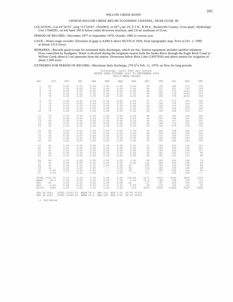
205WILLOW CREEK BASIN
13058530 WILLOW CREEK BELOW FLOODWAY CHANNEL, NEAR UCON, ID
LOCATION.--Lat 43°34'33", long 111°54'43", (NAD83), in SE1⁄4 sec.19, T.3 N., R.39 E., Bonneville County, Ucon quad., HydrologicUnit 17040201, on left bank 100 ft below outlet diversion structure, and 2.0 mi southeast of Ucon.
PERIOD OF RECORD.--December 1977 to September 1979, October 1985 to current year.
GAGE.--Water-stage recorder. Elevation of gage is 4,840 ft above NGVD of 1929, from topographic map. Prior to Oct. 1, 1990,at datum 3.0 ft lower.
REMARKS.--Records good except for estimated daily discharges, which are fair. Station equipment includes satellite telemetry.Flow controlled by headgates. Water is diverted during the irrigation season from the Snake River through the Eagle Rock Canal toWillow Creek about 6.5 mi upstream from the station. Diversions below Ririe Lake (13057950) and above station for irrigation ofabout 1,500 acres.
EXTREMES FOR PERIOD OF RECORD.--Maximum daily discharge, 279 ft3⁄s Feb. 11, 1979; no flow for long periods.
Discharge, cubic feet per secondWATER YEAR OCTOBER 2004 TO SEPTEMBER 2005
DAILY MEAN VALUES
DAY OCT NOV DEC JAN FEB MAR APR MAY JUN JUL AUG SEP
1 83 0.00 0.00 0.00 0.00 0.00 0.00 65 129 184 153 150 2 77 0.00 0.00 0.00 0.00 0.00 0.00 66 157 181 153 152 3 75 0.00 0.00 0.00 0.00 0.00 0.00 66 162 179 e153 153 4 75 0.00 0.00 0.00 0.00 0.00 0.00 58 159 179 e153 153 5 75 0.00 0.00 0.00 0.00 0.00 0.00 62 158 178 e153 152
6 75 0.00 0.00 0.00 0.00 0.00 0.00 67 157 175 153 152 7 75 0.00 0.00 0.00 0.00 0.00 0.00 67 156 176 153 152 8 75 0.00 0.00 0.00 0.00 0.00 0.00 64 146 175 153 151 9 75 0.00 0.00 0.00 0.00 0.00 0.00 62 135 166 153 147 10 75 0.00 0.00 0.00 0.00 0.00 0.00 62 143 165 153 127
11 73 0.00 0.00 0.00 0.00 0.00 0.00 66 151 166 154 102 12 72 0.00 0.00 0.00 0.00 0.00 0.00 66 151 164 151 102 13 64 0.00 0.00 0.00 0.00 0.00 0.00 65 149 167 152 101 14 56 0.00 0.00 0.00 0.00 0.00 0.00 65 148 173 153 102 15 55 0.00 0.00 0.00 0.00 0.00 0.00 65 145 179 154 103
16 55 0.00 0.00 0.00 0.00 0.00 0.00 65 150 188 155 104 17 55 0.00 0.00 0.00 0.00 0.00 0.00 64 154 195 155 103 18 55 0.00 0.00 0.00 0.00 0.00 0.00 60 153 209 147 103 19 53 0.00 0.00 0.00 0.00 0.00 0.00 58 152 205 143 102 20 52 0.00 0.00 0.00 0.00 0.00 0.00 57 152 204 142 101
21 52 0.00 0.00 0.00 0.00 0.00 0.00 57 152 203 144 101 22 47 0.00 0.00 0.00 0.00 0.00 0.00 56 161 205 145 101 23 44 0.00 0.00 0.00 0.00 0.00 0.00 53 185 204 146 101 24 44 0.00 0.00 0.00 0.00 0.00 0.00 50 187 192 147 99 25 43 0.00 0.00 0.00 0.00 0.00 0.00 49 185 181 147 86
26 43 0.00 0.00 0.00 0.00 0.00 0.00 84 185 181 146 74 27 43 0.00 0.00 0.00 0.00 0.00 0.00 102 185 169 146 69 28 43 0.00 0.00 0.00 0.00 0.00 43 104 185 156 146 69 29 32 0.00 0.00 0.00 --- 0.00 66 112 185 156 148 69 30 0.00 0.00 0.00 0.00 --- 0.00 59 117 185 158 148 69 31 0.00 --- 0.00 0.00 --- 0.00 --- 117 --- 156 149 ---
TOTAL 1741.00 0.00 0.00 0.00 0.00 0.00 168.00 2171 4802 5569 4648 3350 MEAN 56.2 0.00 0.00 0.00 0.00 0.00 5.60 70.0 160 180 150 112 MAX 83 0.00 0.00 0.00 0.00 0.00 66 117 187 209 155 153 MIN 0.00 0.00 0.00 0.00 0.00 0.00 0.00 49 129 156 142 69 AC-FT 3450 0.00 0.00 0.00 0.00 0.00 333 4310 9520 11050 9220 6640
CAL YR 2004 TOTAL 21243.50 MEAN 58.0 MAX 162 MIN 0.00 AC-FT 42140 WTR YR 2005 TOTAL 22449.00 MEAN 61.5 MAX 209 MIN 0.00 AC-FT 44530
e Estimated

206SNAKE RIVER MAIN STEM
13060000 SNAKE RIVER NEAR SHELLEY, ID
LOCATION.--Lat 43°24'47", long 112°08'06"(revised), (NAD83), in SE1⁄4SW1⁄4 sec.17, T.1 N., R.37 E., Bingham County, Woodvillequad., Hydrologic Unit 17040206, on right bank 0.3 mi southeast of Woodville, 2.5 mi north of Shelley, and at mile 787.8.
DRAINAGE AREA.--9,790 mi2, approximately, excluding indeterminate nontributary area on Snake River Plain.
PERIOD OF RECORD.--March 1915 to current year (prior to October 1931, irrigation seasons only).
REVISED RECORDS.--WSP 1317: 1916.
GAGE.--Water-stage recorder. Datum of gage is 4,599.0 ft above NGVD of 1929.
REMARKS.--Records good except for estimated daily discharges, which are fair. Station equipment includes satellite telemetry. Someregulation by Jackson Lake, Palisades Reservoir, Island Park Reservoir, Henrys Lake (sta 13039000), and Grassy Lake. Initial fillingof forebay pool at Gem Power plant 2 mi upstream, occurred during March and April of 1988. Diversions above station for irrigationof about 39,000 acres below and about 637,000 acres above station, of which about 100,000 acres are irrigated by withdrawals fromground water (1966 determination). Considerable water leaks above station into Snake River Plain aquifer.
EXTREMES FOR PERIOD OF RECORD.--Maximum discharge, 67,300 ft3⁄s June 6, 1976, gage height, 19.12 ft, result of Teton Damfailure.
Maximum discharge excluding 1976, 47,800 ft3⁄s June 17, 1997, gage height, 16.05 ft; maximum gage height, 16.97 ft, June 17, 1918;minimum, 288 ft3⁄s Nov. 5, 1934, gage height, 2.22 ft.
EXTREMES OUTSIDE PERIOD OF RECORD.--Flood of June 6, 1894, reached an estimated discharge of 75,000 ft3⁄s at former station(13059000) at Eagle Rock (now Idaho Falls), 7 mi upstream from present site.
EXTREMES FOR CURRENT YEAR.--Maximum discharge, 13,000 ft3⁄s June 16, gage height, 8.93 ft; minimum, 1,340 ft3⁄s Mar. 15,gage height, 4.47 ft, caused by regulation at Gem Lake.
Discharge, cubic feet per secondWATER YEAR OCTOBER 2004 TO SEPTEMBER 2005
DAILY MEAN VALUES
DAY OCT NOV DEC JAN FEB MAR APR MAY JUN JUL AUG SEP
1 2800 3780 2280 e2300 2150 1960 2160 3710 5140 5730 5570 4250 2 2520 3430 e2200 e2250 2090 2020 2200 3630 5230 5130 5470 4200 3 2400 3250 e2200 e2300 2070 1980 2050 3390 6120 4880 5460 4180 4 2170 3070 e2300 e2250 2020 1950 1990 3840 6350 4950 5480 4310 5 2120 3050 e2200 e2100 2010 1940 2030 4280 6120 5090 5060 4460
6 2160 3010 e2100 2050 2050 1960 2070 4120 6100 4590 4900 4430 7 2290 2970 2190 2020 2070 1950 1840 4360 6540 4320 4750 4500 8 2200 2860 2440 1920 2050 1990 1750 4950 7520 4720 4710 4360 9 2200 2910 2660 e2000 1960 2000 1890 5300 8030 5240 4640 4090 10 2180 2810 2670 e2200 2040 2000 1970 5430 8040 5330 4550 4240
11 2120 2830 2590 e2300 2030 2010 1790 5870 7740 5560 4720 4570 12 2060 2810 2570 e2200 1910 2130 1670 6340 7940 5530 4810 4810 13 2130 2770 2570 e2100 2090 2100 1590 6370 8740 5430 5140 4560 14 2300 2790 2420 e2100 2030 2110 1810 6300 10300 5560 5290 4380 15 2480 2670 2440 e1900 2080 2050 2490 5880 11400 5460 5340 4420
16 2630 2680 2890 e1600 1890 2090 2770 5680 12200 5450 5310 4510 17 2430 2630 2610 e1650 e1550 2000 2540 6280 11400 5870 5320 4480 18 2330 2620 2400 e2100 e1400 2090 3070 7580 10300 5910 4790 4640 19 2510 2590 2350 e2500 e1800 2020 3820 8200 9360 5660 4820 4770 20 2650 2590 2260 e2550 e2200 1980 3920 8320 8640 5250 5030 4480
21 2610 2580 e2100 e2550 e2300 2110 3920 8540 7330 5480 5200 4320 22 2600 2570 e1900 e2450 e2100 2140 3100 8890 6140 5640 5120 4330 23 2590 2410 e1600 e2300 2030 2350 2830 9130 5890 5870 4940 4330 24 2660 2520 e1700 e2200 2010 2280 2690 8850 6070 5770 4450 3950 25 2930 2530 1890 e2150 2010 2290 2930 8190 6150 5640 4130 3990
26 3030 2560 2290 e2200 2010 2230 3690 7300 6030 5540 4000 4160 27 3040 2630 2450 2250 1960 2080 4640 6350 5950 5280 4040 4150 28 3190 2520 2500 2290 1960 2090 4680 5340 5870 5430 3980 3810 29 3480 2090 2590 2290 --- 2100 4390 4850 5860 5490 4190 3800 30 4060 e2200 2430 2250 --- 2250 4130 5280 5900 5460 4210 3760 31 3910 --- e2400 2210 --- 2240 --- 5460 --- 5350 4210 ---
TOTAL 80780 82730 72190 67530 55870 64490 82420 188010 224400 166610 149630 129240 MEAN 2606 2758 2329 2178 1995 2080 2747 6065 7480 5375 4827 4308 MAX 4060 3780 2890 2550 2300 2350 4680 9130 12200 5910 5570 4810 MIN 2060 2090 1600 1600 1400 1940 1590 3390 5140 4320 3980 3760 AC-FT 160200 164100 143200 133900 110800 127900 163500 372900 445100 330500 296800 256300
STATISTICS OF MONTHLY MEAN DATA FOR WATER YEARS 1915 - 2005, BY WATER YEAR (WY)
MEAN 3143 3506 3566 3476 3707 4605 7359 12320 13030 7361 4808 3773 MAX 9465 7841 8334 8210 11460 15150 19620 28240 34380 19650 9073 7682 (WY) 1972 1984 1984 1984 1997 1997 1986 1928 1997 1917 1997 1971 MIN 646 827 1584 1515 1599 1401 1559 3261 2432 2213 1342 1119 (WY) 1932 1935 1935 1932 1932 1934 1934 1931 1934 1934 1919 1934
SUMMARY STATISTICS FOR 2004 CALENDAR YEAR FOR 2005 WATER YEAR WATER YEARS 1915 - 2005
ANNUAL TOTAL 1399640 1363900 ANNUAL MEAN 3824 3737 5864 HIGHEST ANNUAL MEAN 12330 1997 LOWEST ANNUAL MEAN 1998 1934 HIGHEST DAILY MEAN 14000 May 24 12200 Jun 16 50500 Jun 7 1976 LOWEST DAILY MEAN 1100 Jan 7 1400 Feb 18 350 Nov 5 1934 ANNUAL SEVEN-DAY MINIMUM 1440 Jan 3 1780 Apr 8 412 Nov 2 1934 ANNUAL RUNOFF (AC-FT) 2776000 2705000 4248000 10 PERCENT EXCEEDS 5810 6050 12700 50 PERCENT EXCEEDS 2840 2830 4240 90 PERCENT EXCEEDS 1900 2000 2180
e Estimated

207SNAKE RIVER MAIN STEM
13062500 SNAKE RIVER AT BLACKFOOT, ID
LOCATION.--Lat 43°11'51", long 112°22'09", (NAD83), in SE1⁄4SW1⁄4 sec.33, T.2 S., R.35 E., Bingham County, Blackfoot quad.,Hydrologic Unit 17040206, on left bank immediately upstream from old Riverside Highway bridge, 0.25 mi downstream fromnew U.S. Highway 26 bridge, 1.2 mi west of Blackfoot, and at mile 764.3.
DRAINAGE AREA.--9,950 mi2.
PERIOD OF RECORD.--August 1978 to current year. Records for May 1924 to September 1932 at site downstream, published as“Snake River below Blackfoot Bridge, near Blackfoot”, are not equivalent because diversions were not included.
GAGE.--Water-stage recorder and crest-stage gage. Elevation of gage is 4,490 ft above NGVD of 1929, from topographic map.May 1924 to Sept. 1932, water-stage recorder at site downstream at different datum.
REMARKS.--Records good except for estimated daily discharges, which are fair. Station equipment includes satellite telemetry.Flow regulated by Jackson Lake, Palisades Reservoir, Henrys Lake, Island Park Reservoir, and Grassy Lake, having a combinedcapacity of 2,570,000 acre-ft. Diversions above station for irrigation of about 750,000 acres. Considerable water leaks above thestation into the Snake River Plain aquifer.
EXTREMES FOR PERIOD OF RECORD.--Maximum discharge, 43,200 ft3⁄s June 17, 1997, gage height, 13.55 ft; maximum gage height,14.71 ft, Feb. 7, 1985, result of backwater from ice; minimum, 2.7 ft3⁄s Apr. 29, 1992, gage height, 0.91 ft, caused by irrigationdiversions.
EXTREMES FOR CURRENT YEAR.--Maximum discharge, 9,540 ft3⁄s June 17, gage height, 7.45 ft; minimum, 836 ft3⁄s July 7,gage height, 4.31 ft.
Discharge, cubic feet per secondWATER YEAR OCTOBER 2004 TO SEPTEMBER 2005
DAILY MEAN VALUES
DAY OCT NOV DEC JAN FEB MAR APR MAY JUN JUL AUG SEP
1 1940 3530 e2100 e2100 e2000 1670 1900 2330 1820 2290 2800 1530 2 1750 3200 e2000 e2100 e1900 1690 1830 2150 1850 1940 2880 1550 3 1570 2980 e2100 e2100 e1900 1720 1810 1810 2450 1670 2690 1510 4 1400 2780 e2200 e2000 e1800 1660 1700 1900 3050 1550 2910 1600 5 e1200 2770 e2100 e2000 e1800 1640 1670 2360 2950 1760 2450 1750
6 1290 2710 e1900 e1900 e1800 1650 1770 2310 2880 1440 2210 1820 7 1390 2670 e2100 e1700 e1800 1660 1600 2310 3220 992 2050 1880 8 1390 2610 e2200 e1800 e1900 1690 1410 2740 4210 1190 1960 1830 9 1400 2600 e2300 e1700 e1800 1690 1440 3230 4950 1680 1960 1600 10 1440 2540 e2500 e1900 e1800 1700 1650 3330 5120 1820 1840 1620
11 1430 2540 e2400 e2000 e1800 1700 1520 3690 4980 2020 1930 1880 12 1400 2550 e2300 e2000 e1800 1750 1350 4290 4860 2070 1900 2330 13 1320 2480 2340 e1900 e1800 1820 1240 4480 5450 2010 2390 2180 14 1520 2490 2190 e1700 e1900 1820 1200 4460 6620 2120 2510 2050 15 1710 2430 2120 e1700 e1800 1750 1930 4100 7690 2100 2640 2110
16 2240 2390 2410 e1600 e1800 1780 2300 3830 8430 2050 2680 2230 17 2180 2380 2470 e1400 e1500 1750 2290 4170 8130 2390 2650 2280 18 1980 2330 2110 e1600 e1400 1750 2360 5260 7160 2580 2400 2480 19 2120 2310 2070 e2200 e1600 1760 2990 6060 6290 2610 2220 2730 20 2310 2330 1970 e2400 e1900 1750 3130 6280 5510 2160 2370 2590
21 2240 2310 e1950 e2400 e2200 1720 3100 6350 4310 2180 2550 2410 22 2340 2310 e1800 e2400 e2100 1860 2570 6770 3020 2420 2510 2450 23 2300 2170 e1400 e2200 1840 2020 2140 6870 2460 2710 2400 2500 24 2370 2220 e1400 e2000 1750 2030 2010 6570 2470 2830 1980 2160 25 2510 2240 e1500 e2000 1740 1970 2030 5770 2620 2690 1580 2160
26 2740 e2200 e1700 e1900 1740 2000 2240 4870 2540 2760 1250 2270 27 2660 e2300 e2200 e2000 1690 1840 2960 3730 2450 2450 1290 2380 28 2860 e2200 e2200 e2100 1670 1830 3130 2460 2280 2540 1250 2100 29 3050 e2000 e2300 e2100 --- 1760 3070 1710 2320 2730 1390 1960 30 3520 e1900 e2200 e2100 --- 1870 2620 1790 2340 2680 1450 1930 31 3700 --- e2200 e2000 --- 1980 --- 2140 --- 2680 1470 ---
TOTAL 63270 74470 64730 61000 50530 55280 62960 120120 124430 67112 66560 61870 MEAN 2041 2482 2088 1968 1805 1783 2099 3875 4148 2165 2147 2062 MAX 3700 3530 2500 2400 2200 2030 3130 6870 8430 2830 2910 2730 MIN 1200 1900 1400 1400 1400 1640 1200 1710 1820 992 1250 1510 AC-FT 125500 147700 128400 121000 100200 109600 124900 238300 246800 133100 132000 122700
STATISTICS OF MONTHLY MEAN DATA FOR WATER YEARS 1978 - 2005, BY WATER YEAR (WY)
MEAN 2563 3396 3381 3495 3658 4881 6447 9420 9702 4847 2954 2585 MAX 6093 7926 8271 7995 10910 15280 19450 22080 30360 13150 7400 6099 (WY) 1984 1984 1984 1984 1997 1997 1986 1986 1997 1983 1997 1984 MIN 871 1810 1535 1398 1511 1489 1254 1535 2050 1726 1156 726 (WY) 1982 1982 1989 1989 2002 1988 2003 1988 1988 1985 1981 1981
SUMMARY STATISTICS FOR 2004 CALENDAR YEAR FOR 2005 WATER YEAR WATER YEARS 1978 - 2005
ANNUAL TOTAL 906364 872332 ANNUAL MEAN 2476 2390 4783 HIGHEST ANNUAL MEAN 11120 1997 LOWEST ANNUAL MEAN 2019 1988 HIGHEST DAILY MEAN 11600 May 25 8430 Jun 16 42600 Jun 17 1997 LOWEST DAILY MEAN 426 Apr 20 992 Jul 7 35 Apr 28 1992 ANNUAL SEVEN-DAY MINIMUM 1150 Apr 18 1360 Oct 4 141 Oct 2 1980 ANNUAL RUNOFF (AC-FT) 1798000 1730000 3465000 10 PERCENT EXCEEDS 3370 3220 10900 50 PERCENT EXCEEDS 2180 2110 2760 90 PERCENT EXCEEDS 1500 1560 1500
e Estimated
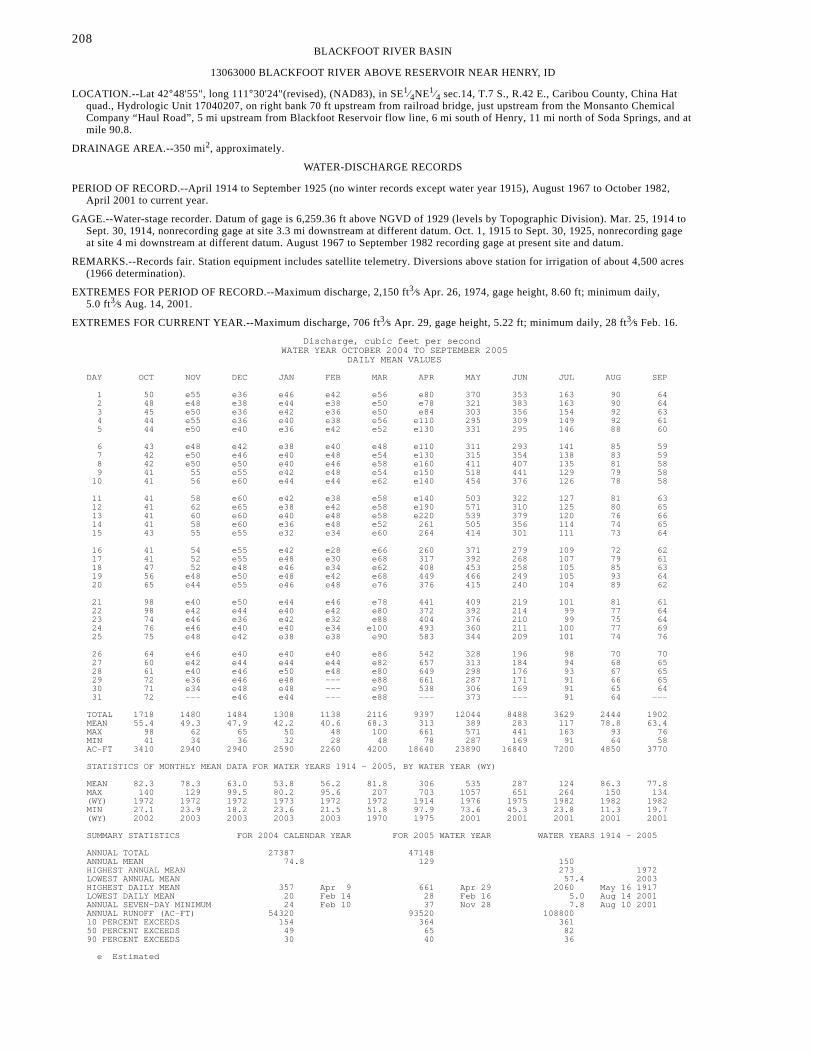
208BLACKFOOT RIVER BASIN
13063000 BLACKFOOT RIVER ABOVE RESERVOIR NEAR HENRY, ID
LOCATION.--Lat 42°48'55", long 111°30'24"(revised), (NAD83), in SE1⁄4NE1⁄4 sec.14, T.7 S., R.42 E., Caribou County, China Hatquad., Hydrologic Unit 17040207, on right bank 70 ft upstream from railroad bridge, just upstream from the Monsanto ChemicalCompany “Haul Road”, 5 mi upstream from Blackfoot Reservoir flow line, 6 mi south of Henry, 11 mi north of Soda Springs, and atmile 90.8.
DRAINAGE AREA.--350 mi2, approximately.
WATER-DISCHARGE RECORDS
PERIOD OF RECORD.--April 1914 to September 1925 (no winter records except water year 1915), August 1967 to October 1982,April 2001 to current year.
GAGE.--Water-stage recorder. Datum of gage is 6,259.36 ft above NGVD of 1929 (levels by Topographic Division). Mar. 25, 1914 toSept. 30, 1914, nonrecording gage at site 3.3 mi downstream at different datum. Oct. 1, 1915 to Sept. 30, 1925, nonrecording gageat site 4 mi downstream at different datum. August 1967 to September 1982 recording gage at present site and datum.
REMARKS.--Records fair. Station equipment includes satellite telemetry. Diversions above station for irrigation of about 4,500 acres(1966 determination).
EXTREMES FOR PERIOD OF RECORD.--Maximum discharge, 2,150 ft3⁄s Apr. 26, 1974, gage height, 8.60 ft; minimum daily,5.0 ft3⁄s Aug. 14, 2001.
EXTREMES FOR CURRENT YEAR.--Maximum discharge, 706 ft3⁄s Apr. 29, gage height, 5.22 ft; minimum daily, 28 ft3⁄s Feb. 16.
Discharge, cubic feet per secondWATER YEAR OCTOBER 2004 TO SEPTEMBER 2005
DAILY MEAN VALUES
DAY OCT NOV DEC JAN FEB MAR APR MAY JUN JUL AUG SEP
1 50 e55 e36 e46 e42 e56 e80 370 353 163 90 64 2 48 e48 e38 e44 e38 e50 e78 321 383 163 90 64 3 45 e50 e36 e42 e36 e50 e84 303 356 154 92 63 4 44 e55 e36 e40 e38 e56 e110 295 309 149 92 61 5 44 e50 e40 e36 e42 e52 e130 331 295 146 88 60
6 43 e48 e42 e38 e40 e48 e110 311 293 141 85 59 7 42 e50 e46 e40 e48 e54 e130 315 354 138 83 59 8 42 e50 e50 e40 e46 e58 e160 411 407 135 81 58 9 41 55 e55 e42 e48 e54 e150 518 441 129 79 58 10 41 56 e60 e44 e44 e62 e140 454 376 126 78 58
11 41 58 e60 e42 e38 e58 e140 503 322 127 81 63 12 41 62 e65 e38 e42 e58 e190 571 310 125 80 65 13 41 60 e60 e40 e48 e58 e220 539 379 120 76 66 14 41 58 e60 e36 e48 e52 261 505 356 114 74 65 15 43 55 e55 e32 e34 e60 264 414 301 111 73 64
16 41 54 e55 e42 e28 e66 260 371 279 109 72 62 17 41 52 e55 e48 e30 e68 317 392 268 107 79 61 18 47 52 e48 e46 e34 e62 408 453 258 105 85 63 19 56 e48 e50 e48 e42 e68 449 466 249 105 93 64 20 65 e44 e55 e46 e48 e76 376 415 240 104 89 62
21 98 e40 e50 e44 e46 e78 441 409 219 101 81 61 22 98 e42 e44 e40 e42 e80 372 392 214 99 77 64 23 74 e46 e36 e42 e32 e88 404 376 210 99 75 64 24 76 e46 e40 e40 e34 e100 493 360 211 100 77 69 25 75 e48 e42 e38 e38 e90 583 344 209 101 74 76
26 64 e46 e40 e40 e40 e86 542 328 196 98 70 70 27 60 e42 e44 e44 e44 e82 657 313 184 94 68 65 28 61 e40 e46 e50 e48 e80 649 298 176 93 67 65 29 72 e36 e46 e48 --- e88 661 287 171 91 66 65 30 71 e34 e48 e48 --- e90 538 306 169 91 65 64 31 72 --- e46 e44 --- e88 --- 373 --- 91 64 ---
TOTAL 1718 1480 1484 1308 1138 2116 9397 12044 8488 3629 2444 1902 MEAN 55.4 49.3 47.9 42.2 40.6 68.3 313 389 283 117 78.8 63.4 MAX 98 62 65 50 48 100 661 571 441 163 93 76 MIN 41 34 36 32 28 48 78 287 169 91 64 58 AC-FT 3410 2940 2940 2590 2260 4200 18640 23890 16840 7200 4850 3770
STATISTICS OF MONTHLY MEAN DATA FOR WATER YEARS 1914 - 2005, BY WATER YEAR (WY)
MEAN 82.3 78.3 63.0 53.8 56.2 81.8 306 535 287 124 86.3 77.8 MAX 140 129 99.5 80.2 95.6 207 703 1057 651 264 150 134 (WY) 1972 1972 1972 1973 1972 1972 1914 1976 1975 1982 1982 1982 MIN 27.1 23.9 18.2 23.6 21.5 51.8 97.9 73.6 45.3 23.8 11.3 19.7 (WY) 2002 2003 2003 2003 2003 1970 1975 2001 2001 2001 2001 2001
SUMMARY STATISTICS FOR 2004 CALENDAR YEAR FOR 2005 WATER YEAR WATER YEARS 1914 - 2005
ANNUAL TOTAL 27387 47148 ANNUAL MEAN 74.8 129 150 HIGHEST ANNUAL MEAN 273 1972 LOWEST ANNUAL MEAN 57.4 2003 HIGHEST DAILY MEAN 357 Apr 9 661 Apr 29 2060 May 16 1917 LOWEST DAILY MEAN 20 Feb 14 28 Feb 16 5.0 Aug 14 2001 ANNUAL SEVEN-DAY MINIMUM 24 Feb 10 37 Nov 28 7.8 Aug 10 2001 ANNUAL RUNOFF (AC-FT) 54320 93520 108800 10 PERCENT EXCEEDS 154 364 361 50 PERCENT EXCEEDS 49 65 82 90 PERCENT EXCEEDS 30 40 36
e Estimated

209BLACKFOOT RIVER BASIN
13063000 BLACKFOOT RIVER ABOVE RESERVOIR NEAR HENRY, ID--Continued
WATER QUALITY RECORDS
PERIOD OF RECORD.--April 2001 to current year.
WATER-QUALITY DATA, WATER YEAR OCTOBER 2004 TO SEPTEMBER 2005
Specif. pH, Dis-Instan- conduc- water, solved Chrom-
Sam- taneous tance, unfltrd Temper- Temper- Dis- oxygen, Arsenic Cadmium ium, Copper,pling dis- wat unf field, ature, ature, solved percent water, water, water, water,
Date Time method, charge, uS/cm std air, water, oxygen, of sat- fltrd, fltrd, fltrd, fltrd,code cfs 25 degC units deg C deg C mg/L uration ug/L ug/L ug/L ug/L
(82398) (00061) (00095) (00400) (00020) (00010) (00300) (00301) (01000) (01025) (01030) (01040)
OCT11... 0350 50 41 357 -- -- -- -- -- .5 <.04 <.8 E.323... 1510 50 72 375 -- -- -- -- -- .5 <.04 <.8 .525... 1250 50 74 387 -- -- -- -- -- .5 <.04 <.8 .4
APR13... 1500 50 323 352 -- -- -- -- -- .7 <.04 <.8 .619... 1845 50 416 300 -- -- -- -- -- .8 E.04 <.8 1.022... 2252 50 385 305 -- -- -- -- -- .8 <.04 <.8 .924... 1214 50 486 265 -- -- -- -- -- .9 E.03 <.8 .927... 1211 50 674 244 -- -- -- -- -- .7 E.03 .12 1.629... 1452 50 688 267 -- -- -- -- -- .9 E.02 <.8 .930... 0416 50 622 287 -- -- -- -- -- .7 E.02 .05 1.330... 2204 50 441 309 -- -- -- -- -- 1.0 <.04 <.8 .8
MAY01... 2119 50 343 325 -- -- -- -- -- .6 <.04 .10 1.202... 2330 50 317 328 -- -- -- -- -- .7 <.04 .07 1.304... 0341 50 292 334 -- -- -- -- -- .6 <.04 .06 1.205... 0615 50 339 319 -- -- -- -- -- .6 <.04 .06 1.106... 1250 50 305 331 8.1 -- 9.3 9.3 103 1.0 .04 <.8 .606... 1300 70 305 331 8.1 -- 9.3 9.3 103 .9 <.04 <.8 .606... 1320 10 305 331 8.1 -- 9.3 9.3 103 1.0 <.04 <.8 .707... 1610 50 319 339 -- -- -- -- -- .6 <.04 .06 1.009... 0602 50 517 308 -- -- -- -- -- .9 <.04 <.8 .910... 1655 50 445 328 -- -- -- -- -- .6 <.04 .07 1.412... 1550 50 581 315 -- -- -- -- -- .8 E.04 <.8 .914... 1521 50 510 332 -- -- -- -- -- .6 <.04 .06 1.215... 1037 50 411 343 -- -- -- -- -- .6 <.04 .06 1.416... 0839 50 372 347 -- -- -- -- -- 1.0 <.04 <.8 .617... 0656 50 381 343 -- -- -- -- -- .6 <.04 .07 .618... 2039 50 481 332 -- -- -- -- -- .8 <.04 E.4 .722... 0321 50 396 342 -- -- -- -- -- .7 <.04 .05 1.129... 0839 50 288 360 -- -- -- -- -- .8 <.04 <.8 .4
JUN02... 0949 50 383 351 -- -- -- -- -- .8 <.04 <.8 .507... 1732 50 372 358 -- -- -- -- -- .7 <.04 <.8 .514... 1300 50 351 366 8.3 21.4 12.7 9.8 117 .7 <.04 <.8 .414... 1310 70 351 366 8.3 21.4 12.7 9.8 117 .7 E.04 <.8 E.4
AUG16... 1320 50 72 290 8.3 -- 17.8 9.3 123 .6 .06 <.8 .416... 1330 70 72 290 8.3 -- 17.8 9.3 123 .6 .09 <.8 E.316... 1350 10 72 290 8.3 -- 17.8 9.3 123 .6 .26 <.8 E.3
< Less than. E Estimated.
Sampling Method Codes: 10 EWI sample 50 Automatic point sample 70 Manual point sample

210BLACKFOOT RIVER BASIN
13063000 BLACKFOOT RIVER ABOVE RESERVOIR NEAR HENRY, ID--Continued
Selen- Vanad- Nickel, ium, ium, Zinc, water, water, water, water, Date fltrd, fltrd, fltrd, fltrd, ug/L ug/L ug/L ug/L (01065) (01145) (01085) (01090)
OCT 11... .20 .9 .9 1.0 23... .32 .8 .8 E.6 25... .39 1.1 .7 .7 APR 13... 2.16 1.1 1.1 1.1 19... 2.47 3.4 1.1 3.8 22... 2.65 3.7 1.1 1.0 24... 2.23 3.2 1.3 1.5 27... .83 2.8 1.4 10.7 29... 2.45 5.1 1.1 .9 30... .89 5.8 1.1 E.3 30... 2.66 7.4 1.2 E.5 MAY 01... .71 7.0 1.3 E.4 02... .63 6.5 1.3 <.6 04... .67 6.7 1.2 <.6 05... .61 5.6 1.1 .6 06... 1.20 7.1 1.1 1.1 06... 1.17 7.2 1.2 E.6 06... 1.30 7.5 1.2 E.5 07... .58 6.2 1.1 E.4 09... 2.95 5.0 1.1 .6 10... .93 6.1 1.1 E.3 12... 3.19 5.0 1.1 1.2 14... .92 5.2 1.1 E.3 15... .72 6.0 1.2 E.4 16... 2.71 6.3 1.1 E.4 17... .56 5.6 1.1 <.6 18... 2.65 4.9 1.0 E.4 22... .55 4.2 1.2 <.6 29... 2.47 3.2 1.1 <.6 JUN 02... 2.66 2.1 1.1 E.3 07... 2.73 1.8 .8 .7 14... 2.54 1.9 .9 E.3 14... 2.58 1.8 1.0 E.4 AUG 16... 1.33 1.2 1.9 1.0 16... 1.20 1.2 2.1 .7 16... 1.09 1.3 2.0 E.6
< Less than. E Estimated.

211BLACKFOOT RIVER BASIN
13066000 BLACKFOOT RIVER NEAR SHELLEY, ID
LOCATION.--Lat 43°15'46", long 112°02'52", (NAD83), in NW1⁄4SW1⁄4NE1⁄4 sec.7, T.2 S., R.38 E., Bingham County, Goshen quad.,Hydrologic Unit 17040207, on right bank 1.2 mi downstream from Wolverine Creek, 8.5 mi southeast of Shelley, and at mile 30.5.
DRAINAGE AREA.--909 mi2.
PERIOD OF RECORD.--July 1909 to November 1926, May 1927 to September 1950 (irrigation seasons only, monthly means, furnishedby the Office of Indian Affairs), August 1975 to current year.
GAGE.--Water-stage recorder. Elevation of gage is 4,650 ft above NGVD of 1929, from topographic map. Prior to Aug. 19, 1975, atnearby site at different datum.
REMARKS.--Records good except for estimated daily discharges, which are fair. Flow regulated by Blackfoot Reservoir (sta 13065000)38.5 mi upstream. Water diverted from reservoir and several other diversions upstream for irrigation. Water diverted at times fromGrays Lake near Wayan (Willow Creek basin).
EXTREMES FOR PERIOD OF RECORD.--Maximum discharge, 3,220 ft3⁄s May 16, 1987, gage height, 9.10 ft, from flash flood;maximum gage height, 19.97 ft, Nov. 29, 1975, backwater from ice; minimum observed, 15 ft3⁄s Jan. 23, 1919, gage height, 2.83 ft,site and datum then in use.
EXTREMES FOR CURRENT YEAR.--Maximum daily discharge, 668 ft3⁄s July 14; minimum daily, 50 ft3⁄s Jan. 15.
Discharge, cubic feet per secondWATER YEAR OCTOBER 2004 TO SEPTEMBER 2005
DAILY MEAN VALUES
DAY OCT NOV DEC JAN FEB MAR APR MAY JUN JUL AUG SEP
1 140 93 e60 e70 72 72 88 116 314 597 502 383 2 134 90 e60 e70 e70 66 89 112 314 600 367 421 3 135 90 e60 e75 e65 68 103 112 298 587 356 382 4 135 96 e65 e75 e65 72 117 121 294 572 350 367 5 135 91 e75 e70 e70 69 103 121 294 570 353 347
6 120 91 e75 e70 e65 69 97 118 355 567 355 345 7 107 90 e80 e70 e70 70 114 133 355 562 358 291 8 106 90 e85 e70 e70 74 126 174 197 558 365 288 9 106 90 89 73 e70 80 129 164 146 633 363 291 10 108 90 90 78 e70 85 123 174 134 637 398 298
11 108 91 88 82 e70 84 121 199 129 631 399 298 12 107 90 84 e80 74 89 125 218 144 629 396 297 13 107 90 79 e70 72 94 156 181 135 622 397 266 14 107 89 74 e55 71 80 196 166 129 668 396 259 15 108 89 77 e50 e65 76 180 148 218 666 391 259
16 108 88 77 e55 e60 77 142 153 257 660 395 288 17 108 89 e65 e65 e60 79 144 182 477 650 397 304 18 115 88 e65 e80 e60 75 165 194 656 642 402 302 19 113 89 e70 81 e80 80 151 180 659 552 369 304 20 115 85 e70 81 e75 98 146 169 641 549 361 311
21 118 e80 69 77 e75 89 158 159 637 546 359 293 22 109 e75 e65 73 e75 87 145 151 633 641 354 287 23 109 e75 e60 e80 e70 96 134 146 630 647 357 281 24 115 e85 e65 e80 e70 104 133 140 622 640 322 290 25 106 96 e70 e75 e70 88 131 137 578 640 312 281
26 105 97 e80 e80 e70 87 131 132 583 579 312 278 27 99 e75 e85 e80 e70 85 128 129 574 558 308 227 28 96 e70 85 77 e70 95 133 127 572 553 308 212 29 105 e55 85 75 --- 104 143 245 565 559 305 171 30 99 e55 82 74 --- 95 124 294 551 508 302 148 31 100 --- 77 71 --- 88 --- 298 --- 502 363 ---
TOTAL 3483 2562 2311 2262 1944 2575 3975 5093 12091 18525 11272 8769 MEAN 112 85.4 74.5 73.0 69.4 83.1 132 164 403 598 364 292 MAX 140 97 90 82 80 104 196 298 659 668 502 421 MIN 96 55 60 50 60 66 88 112 129 502 302 148 AC-FT 6910 5080 4580 4490 3860 5110 7880 10100 23980 36740 22360 17390
STATISTICS OF MONTHLY MEAN DATA FOR WATER YEARS 1909 - 2005, BY WATER YEAR (WY)
MEAN 211 161 129 124 141 192 314 558 742 729 561 396 MAX 626 563 760 783 1065 966 1042 1832 1852 1349 959 827 (WY) 1915 1985 1984 1984 1997 1986 1913 1986 1984 1984 1922 1977 MIN 64.3 49.7 43.0 40.6 45.0 69.1 74.9 132 138 89.1 188 112 (WY) 1993 1993 1993 1993 1993 1992 2003 1991 1925 1910 1993 2003
SUMMARY STATISTICS FOR 2004 CALENDAR YEAR FOR 2005 WATER YEAR WATER YEARS 1909 - 2005
ANNUAL TOTAL 63772 74862 ANNUAL MEAN 174 205 359 HIGHEST ANNUAL MEAN 807 1984 LOWEST ANNUAL MEAN 143 1925 HIGHEST DAILY MEAN 632 Jun 10 668 Jul 14 2020 May 18 1976 LOWEST DAILY MEAN 30 Feb 12 50 Jan 15 27 Dec 26 1919 ANNUAL SEVEN-DAY MINIMUM 44 Feb 8 61 Nov 28 34 Jan 31 1921 ANNUAL RUNOFF (AC-FT) 126500 148500 259800 10 PERCENT EXCEEDS 424 558 823 50 PERCENT EXCEEDS 109 115 213 90 PERCENT EXCEEDS 55 70 68
e Estimated

212BLACKFOOT RIVER BASIN
13068495 BLACKFOOT RIVER BYPASS NEAR BLACKFOOT, ID
LOCATION.--Lat 43°10'15", long 112°23'16", (NAD83), in SE1⁄4SW1⁄4 sec.8, T.3 S., R.35 E., Bingham County, Moreland quad.,Hydrologic Unit 17040207, on right bank of the Blackfoot River at the flood diversion structure, about 400 ft downstream fromInterstate 15 bridges, and 2.5 mi southwest of Blackfoot.
PERIOD OF RECORD.--April 1964 to current year. (Prior to 1978, only combined monthly flows of main river and of bypass channelwere published.)
GAGE.--Water-stage recorder. Datum of gage is 4,469.0 ft above NGVD of 1929 (levels by U.S. Army Corps of Engineers).
REMARKS.--Records fair except for estimated daily discharges, which are poor. Station equipment includes satellite telemetry.Flow regulated by Blackfoot Reservoir (sta 13065000). Diversions above station for irrigation.
EXTREMES FOR PERIOD OF RECORD.--Maximum daily discharge, 1,460 ft3⁄s May 5, 1974; no flow for long periods.
Discharge, cubic feet per secondWATER YEAR OCTOBER 2004 TO SEPTEMBER 2005
DAILY MEAN VALUES
DAY OCT NOV DEC JAN FEB MAR APR MAY JUN JUL AUG SEP
1 7.5 15 e0.50 e1.0 e0.00 3.9 0.75 124 0.07 1.00 44 0.00 2 15 10 e1.0 e0.50 e0.00 2.4 2.0 128 2.1 1.9 59 0.00 3 17 10 e1.0 e0.50 e0.00 1.7 2.0 73 20 0.59 13 0.00 4 19 11 e1.0 e0.50 e0.00 2.3 10 39 48 1.7 1.6 0.00 5 38 11 e1.5 e0.50 e0.00 1.5 11 49 53 0.34 1.1 0.50
6 77 9.8 e2.0 e0.50 e0.00 1.5 4.7 41 68 0.00 0.54 0.73 7 134 9.9 e2.5 e0.50 e0.00 1.7 3.9 22 93 0.04 0.00 0.66 8 103 9.6 e3.0 e0.20 e0.00 1.5 12 23 123 0.27 0.00 0.10 9 63 9.9 e3.5 e1.0 e0.00 2.5 18 16 88 0.00 0.00 0.00 10 50 9.2 e4.0 e0.50 e0.00 3.8 17 12 33 1.1 0.00 0.00
11 37 9.2 e5.0 e0.50 e1.0 4.0 14 13 11 2.8 0.48 0.57 12 39 9.4 e4.5 e0.50 1.6 3.6 14 24 10 1.2 0.16 5.0 13 38 9.0 e4.0 e0.50 1.1 6.6 17 42 5.2 0.00 0.00 6.8 14 43 8.4 e2.5 e0.00 1.4 3.6 39 33 4.2 0.19 0.00 22 15 76 8.0 e2.5 e0.00 e0.00 1.3 55 22 0.11 0.11 0.00 6.5
16 91 7.2 e2.0 e0.00 e0.00 0.63 39 19 1.1 0.54 0.00 1.3 17 23 7.3 e1.0 e0.00 e0.00 0.37 28 55 0.60 5.1 0.00 0.00 18 15 7.3 e0.00 e0.00 e1.5 0.21 33 111 0.00 17 0.00 0.93 19 20 7.2 e0.50 e0.00 e3.0 0.00 41 150 0.00 17 0.27 2.2 20 21 7.0 e1.0 e0.00 6.2 2.8 36 127 6.7 2.8 0.00 0.67
21 45 e1.0 e0.50 e0.00 3.5 5.6 36 93 2.7 1.9 0.00 0.00 22 39 e0.50 e0.00 e0.00 2.8 3.5 47 57 1.1 1.7 0.21 0.58 23 26 1.9 e0.00 e0.00 2.9 4.9 43 25 0.32 7.2 0.45 0.40 24 32 11 e0.00 e0.00 1.7 10 38 13 3.0 35 0.17 0.50 25 30 9.4 e0.00 e0.00 1.8 7.1 27 4.1 3.1 33 0.00 0.69
26 31 11 e0.00 e0.50 2.0 2.7 12 2.9 2.3 29 0.00 0.71 27 28 e3.5 e1.0 e1.0 2.3 1.7 11 1.8 0.09 7.8 0.00 0.78 28 24 e0.35 e3.0 e1.0 2.5 2.2 31 0.07 0.00 1.5 0.00 0.74 29 32 e0.00 e4.5 e0.50 --- 7.7 47 0.00 0.00 1.4 0.00 0.44 30 31 e1.0 e4.0 e0.00 --- 7.3 77 0.00 0.00 3.8 0.00 0.00 31 19 --- e3.0 e0.00 --- 4.4 --- 1.6 --- 15 0.00 ---
TOTAL 1263.5 225.05 59.00 10.20 35.30 103.01 766.35 1321.47 579.69 190.98 120.98 52.80 MEAN 40.8 7.50 1.90 0.33 1.26 3.32 25.5 42.6 19.3 6.16 3.90 1.76 MAX 134 15 5.0 1.0 6.2 10 77 150 123 35 59 22 MIN 7.5 0.00 0.00 0.00 0.00 0.00 0.75 0.00 0.00 0.00 0.00 0.00 AC-FT 2510 446 117 20 70 204 1520 2620 1150 379 240 105
CAL YR 2004 TOTAL 3837.91 MEAN 10.5 MAX 254 MIN 0.00 AC-FT 7610 WTR YR 2005 TOTAL 4728.33 MEAN 13.0 MAX 150 MIN 0.00 AC-FT 9380
e Estimated

213BLACKFOOT RIVER BASIN
13068500 BLACKFOOT RIVER NEAR BLACKFOOT, ID
LOCATION.--Lat 43°07'50", long 112°28'36", (NAD83), near E1⁄4 corner, sec.28, T.3 S., R.34 E., Bingham County, Moreland quad.,Hydrologic Unit 17040207, Fort Hall Indian Reservation, on left bank 11 ft upstream from highway bridge, 8 mi southwest ofBlackfoot, and at mile 3.4.
DRAINAGE AREA.--1,295 mi2, including that of Sand Creek, flow of which is diverted to Blackfoot River through the Idaho Canal.
WATER-DISCHARGE RECORDSPERIOD OF RECORD.--July 1913 to current year (prior to October 1931, summer months only). Monthly discharge only for some
periods, published in WSP 1317.
REVISED RECORDS.--WSP 1217: Drainage area.
GAGE.--Water-stage recorder. Elevation of gage is 4,420 ft above NGVD of 1929, from river-profile survey. Prior to May 8, 1926,nonrecording gage, and May 8, 1926 to June 25, 1937, water-stage recorder at site 0.5 mi upstream at different datum. June 26, 1937to Aug. 16, 1963, water-stage recorder at site 175 ft downstream at same datum.
REMARKS.--Records good except for estimated daily discharges and discharges below 10 ft3⁄s, which are poor. Station equipmentincludes satellite telemetry. Flow regulated by Blackfoot Reservoir. Diversions above station for irrigation of about 28,000 acres belowand about 32,000 acres above station, of which about 900 acres are irrigated by withdrawals from ground water (1966 determination).Part of flow is supplied by waste water from Snake River canals. Diversions to bypass channel 5.5 mi upstream from station began inApril 1964. For records and statistics of combined discharges, see station 13068501.
EXTREMES FOR PERIOD OF RECORD.--Maximum discharge, 1,710 ft3⁄s Feb. 11, 1962, gage height, 7.68 ft, prior to Blackfoot RiverBypass channel diversion.
Since 1964, river only: maximum discharge, 740 ft3⁄s June 12, 1984, gage height, 5.53 ft; maximum gage height, 6.77 ft, June 16, 1997,(backwater from the Snake River); no flow at times some years.
Combined flow since 1913: maximum discharge, 2,130 ft3⁄s May 5, 1974; no flow at times some years.
EXTREMES FOR CURRENT YEAR.--River only: maximum daily discharge, 279 ft3⁄s Aug. 2; no flow July 16, Aug. 21, Sept. 4.
Combined flow with Bypass channel: maximum daily discharge, 375 ft3⁄s May 19; no flow Aug. 21, Sept. 4.
Discharge, cubic feet per secondWATER YEAR OCTOBER 2004 TO SEPTEMBER 2005
DAILY MEAN VALUES
DAY OCT NOV DEC JAN FEB MAR APR MAY JUN JUL AUG SEP
1 45 81 e50 e60 81 78 77 197 3.3 15 230 3.5 2 73 73 e50 e60 82 89 80 199 9.0 6.9 279 2.8 3 80 72 e50 e65 e70 82 75 142 32 6.9 e107 0.74 4 79 73 e55 e60 e65 84 89 100 52 11 e44 0.00 5 94 74 e65 e55 e65 87 98 115 47 1.5 e33 0.98
6 133 70 e65 e55 e60 78 89 105 88 0.14 51 15 7 174 70 e70 e55 e65 78 83 60 134 0.10 3.6 20 8 165 68 e75 e55 e65 78 91 38 185 3.4 0.41 17 9 132 66 e80 e60 e65 80 101 55 190 0.56 2.9 7.6 10 117 66 e80 e65 e65 85 107 53 91 6.4 7.2 13
11 102 66 79 e70 e65 89 103 26 41 36 14 26 12 111 66 78 e65 e65 86 100 38 20 5.1 30 73 13 111 65 74 e55 e80 89 100 83 35 2.1 1.5 135 14 115 65 67 e40 e80 96 120 98 17 2.0 3.8 163 15 138 64 65 e35 e75 82 147 90 19 5.6 5.3 162
16 168 63 66 e40 e65 78 140 77 13 0.00 7.3 71 17 96 63 52 e50 e60 77 117 76 12 20 2.5 32 18 76 63 e55 e60 e70 79 115 170 0.89 68 6.2 28 19 80 63 e60 e70 e80 71 132 225 0.62 85 21 109 20 89 64 e60 e75 e85 79 125 228 9.2 63 1.9 66
21 63 e55 e60 e75 e85 93 134 198 12 26 0.00 20 22 118 e50 e55 e70 e85 85 108 171 15 33 12 35 23 95 49 e50 e70 e80 87 137 113 15 44 5.1 43 24 103 69 e55 e70 78 96 126 80 15 134 4.3 40 25 108 76 e60 e65 77 101 122 35 36 179 0.23 35
26 106 74 e65 e75 77 85 86 44 8.5 184 1.7 73 27 97 68 e75 e80 74 81 75 16 9.0 114 0.77 81 28 89 e60 e75 e85 75 80 101 5.4 17 89 0.09 81 29 95 e40 e75 e85 --- 86 123 3.8 16 26 2.9 76 30 101 e42 e70 e85 --- 96 157 16 12 64 10 39 31 87 --- e65 86 --- 88 --- 16 --- 183 2.6 ---
TOTAL 3240 1938 2001 1996 2039 2623 3258 2873.2 1154.51 1414.70 891.30 1468.62 MEAN 105 64.6 64.5 64.4 72.8 84.6 109 92.7 38.5 45.6 28.8 49.0 MAX 174 81 80 86 85 101 157 228 190 184 279 163 MIN 45 40 50 35 60 71 75 3.8 0.62 0.00 0.00 0.00 AC-FT 6430 3840 3970 3960 4040 5200 6460 5700 2290 2810 1770 2910

214BLACKFOOT RIVER BASIN
13068500 BLACKFOOT RIVER NEAR BLACKFOOT, ID--Continued
STATISTICS OF MONTHLY MEAN DATA FOR WATER YEARS 1964 - 2005, BY WATER YEAR (WY)
OCT NOV DEC JAN FEB MAR APR MAY JUN JUL AUG SEP
MEAN 196 167 109 104 116 150 189 221 173 111 124 125 MAX 314 318 314 302 345 386 428 587 469 288 323 263 (WY) 1977 1984 1984 1985 1997 1986 1986 1983 1984 1984 1984 1971 MIN 37.2 45.1 22.3 20.1 21.9 57.5 45.1 34.7 19.9 1.21 0.26 1.11 (WY) 1993 1993 1993 1993 1993 1967 2003 2003 2003 2003 1992 1992
SUMMARY STATISTICS FOR 2004 CALENDAR YEAR FOR 2005 WATER YEAR a WATER YEARS 1964 - 2005
ANNUAL TOTAL 23119.25 24897.33 ANNUAL MEAN 63.2 68.2 149 HIGHEST ANNUAL MEAN 298 1984 LOWEST ANNUAL MEAN 48.7 1992 HIGHEST DAILY MEAN 288 Jun 13 279 Aug 2 733 Jun 12 1984 LOWEST DAILY MEAN 0.00 May 3 0.00 Jul 16 0.00 Jun 2 1977 ANNUAL SEVEN-DAY MINIMUM 0.15 Sep 2 2.2 Aug 23 0.00 Aug 10 1992 ANNUAL RUNOFF (AC-FT) 45860 49380 107900 10 PERCENT EXCEEDS 117 121 296 50 PERCENT EXCEEDS 62 70 120 90 PERCENT EXCEEDS 5.1 5.5 40
a Monthly and Summary Statistics for period since the diversion of water began intoBlackfoot River Bypass channel (Apr. 1964).
e Estimated

215BLACKFOOT RIVER BASIN
13068500 BLACKFOOT RIVER NEAR BLACKFOOT, ID--Continued
WATER-QUALITY RECORDS
PERIOD OF RECORD.--Water years 1966, 1968-1970, 1972-1981, July 1989 to November 2002, July to September 2003, April toSeptember 2004, April to September 2005.
PERIOD OF DAILY RECORD.--WATER TEMPERATURE: May to September 1996, May to September 1999, April to September 2001, December 2001 to November 2002, April 2004 to current year.
INSTRUMENTATION.--Temperature recording data logger.
EXTREMES FOR PERIOD OF DAILY RECORD.--WATER TEMPERATURE: Maximum, 34.1 oC July 12, 2002; minimum, 0.0 oC many days during winter months.
EXTREMES FOR CURRENT YEAR.--WATER TEMPERATURE: Maximum, 29.8 oC July 12-13; minimum, 0.0 oC many days during winter months.
WATER-QUALITY DATA, WATER YEAR OCTOBER 2004 TO SEPTEMBER 2005
Turbdty Ammonia NitriteSpecif. pH, white Dis- E coli, + +
Instan- conduc- water, light, solved modif. Ammonia org-N, nitratetaneous tance, unfltrd Temper- Temper- det ang Dis- oxygen, m-TEC, water, water, water
dis- wat unf field, ature, ature, 90+/-30 solved percent water, fltrd, unfltrd fltrd,Date Time charge, uS/cm std air, water, corrctd oxygen, of sat- col/ mg/L mg/L mg/L
cfs 25 degC units deg C deg C NTRU mg/L uration 100 mL as N as N as N(00061) (00095) (00400) (00020) (00010) (63676) (00300) (00301) (90902) (00608) (00625) (00631)
APR14... 1100 130 530 8.4 5.7 7.3 47 10.3 100 270 .013 .77 E.011
MAY10... 1400 52 341 8.9 13.8 13.7 5.9 12.2 140 55 .011 .28 <.016
JUN09... 1540 138 323 9.0 17.2 16.3 8.3 11.9 143 25 <.010 .25 <.016
JUL11... 1620 36 302 8.9 30.0 25.4 2.7 14.7 210 110 E.005 .49 <.016
AUG17... 1555 5.0 274 9.2 29.4 24.6 3.6 5.2 74 190 <.010 .37 <.016
SEP14... 1630 173 343 9.0 22.1 15.2 4.3 11.6 136 130 <.010 .48 <.016
Ortho- Bicar- Carbon- ANC,phos- bonate, ate, wat unfphate, Phos- Hard- Magnes- Potas- wat unf wat unf fixed Chlor-water, phorus, ness, Calcium ium, Sodium, sium, fixed fixed end pt, Sulfate ide,fltrd, water, water, water, water, water, water, end pt, end pt, field, water, water,
Date mg/L unfltrd mg/L as fltrd, fltrd, fltrd, Sodium, fltrd, field, field, mg/L as fltrd, fltrd,as P mg/L CaCO3 mg/L mg/L mg/L percent mg/L mg/L mg/L CaCO3 mg/L mg/L
(00671) (00665) (00900) (00915) (00925) (00930) (00932) (00935) (00440) (00445) (00410) (00945) (00940)
APR14... .006 .151 -- -- -- -- -- -- -- -- -- -- --
MAY10... E.004 .031 -- -- -- -- -- -- -- -- -- -- --
JUN09... E.003 .034 -- -- -- -- -- -- -- -- -- -- --
JUL11... <.006 .036 -- -- -- -- -- -- -- -- -- -- --
AUG17... E.003 .017 -- -- -- -- -- -- -- -- -- -- --
SEP14... <.006 .065 170 45.1 13.5 10.8 12 2.34 151 7 135 31.6 8.84
Sus- pended Fluor- sedi- ide, Silica, ment water, water, concen- Date fltrd, fltrd, tration mg/L mg/L mg/L (00950) (00955) (80154)
APR 14... -- -- 95 MAY 10... -- -- 8 JUN 09... -- -- 16 JUL 11... -- -- 2 AUG 17... -- -- 2 SEP 14... .6 9.9 39
< Less than. E Estimated.

216BLACKFOOT RIVER BASIN
13068500 BLACKFOOT RIVER NEAR BLACKFOOT, ID--Continued
Temperature, water, degrees CelsiusWATER YEAR OCTOBER 2004 TO SEPTEMBER 2005
DAY MAX MIN MAX MIN MAX MIN MAX MIN MAX MIN MAX MIN
OCTOBER NOVEMBER DECEMBER JANUARY FEBRUARY MARCH
1 16.4 13.0 4.9 2.6 0.1 0.1 0.3 0.0 3.0 0.3 7.0 2.1 2 16.8 12.4 5.3 2.3 0.1 0.0 0.2 0.1 2.9 0.7 7.1 1.7 3 16.8 12.2 5.1 2.8 0.1 0.0 0.1 0.1 2.5 0.1 5.0 2.3 4 16.1 12.2 6.3 3.4 0.1 0.0 0.1 0.1 1.7 0.1 6.8 2.2 5 16.1 11.9 6.8 3.7 0.1 0.0 0.1 0.1 1.2 0.1 7.6 1.7
6 15.5 11.1 7.1 3.9 --- --- 0.1 0.1 0.6 0.1 9.0 3.3 7 15.3 12.1 7.0 3.9 --- --- 0.2 0.1 2.3 0.0 8.1 4.1 8 16.3 12.5 4.9 4.0 --- --- 0.1 0.1 1.6 0.1 10.2 4.0 9 15.0 12.2 6.8 3.7 0.1 0.0 0.1 0.0 1.6 0.1 11.5 5.3 10 13.3 11.8 6.8 4.9 3.9 0.0 0.1 0.1 2.3 0.0 12.3 6.5
11 13.3 10.4 6.5 5.3 3.9 2.4 0.1 0.1 0.6 0.1 12.2 6.3 12 13.3 9.7 7.2 4.6 3.8 2.4 0.1 0.1 2.1 0.3 10.9 6.3 13 13.3 9.3 6.3 4.8 3.1 1.5 0.1 0.1 2.9 1.0 9.3 4.1 14 13.3 9.3 5.6 4.3 2.7 0.7 0.2 0.1 2.6 0.3 7.8 2.8 15 12.4 9.6 6.3 3.8 3.1 1.7 0.2 0.1 2.0 0.1 6.5 2.7
16 12.4 9.9 5.0 3.2 3.3 1.2 0.2 0.1 0.6 0.1 5.8 2.6 17 12.2 10.1 5.3 3.4 1.7 0.3 0.1 0.1 0.2 0.1 7.5 2.5 18 10.5 8.1 4.6 2.7 1.0 0.1 0.1 0.0 0.2 0.1 7.1 2.6 19 10.1 7.7 4.0 2.8 1.1 0.1 0.1 0.0 0.2 0.1 8.4 4.5 20 9.6 8.7 3.4 1.7 1.7 0.0 0.1 0.0 0.2 0.1 9.1 5.3
21 9.9 7.6 2.2 0.0 0.3 0.0 0.1 0.1 5.0 0.1 8.5 4.6 22 8.1 6.5 1.6 0.0 0.2 0.1 0.2 0.0 5.1 1.0 6.0 4.3 23 7.4 6.7 2.5 0.5 0.2 0.1 0.2 0.0 5.4 0.3 6.5 4.5 24 6.7 5.6 2.0 1.1 0.2 0.1 0.2 0.0 4.8 0.2 7.2 3.1 25 7.4 4.9 2.9 2.0 0.2 0.1 0.2 0.0 5.1 0.2 7.0 3.2
26 7.6 5.7 2.9 1.1 0.2 0.0 0.2 0.0 5.2 0.4 9.2 2.6 27 8.8 6.7 1.3 0.4 0.1 0.0 0.1 0.0 5.5 0.5 9.9 4.9 28 8.1 6.8 0.4 0.0 0.1 0.0 0.1 0.0 4.2 0.7 9.0 5.4 29 7.1 5.7 0.2 0.0 0.1 0.1 0.4 0.1 --- --- 5.5 3.5 30 6.3 5.6 0.1 0.0 1.7 0.1 2.9 0.4 --- --- 6.2 2.2 31 5.9 3.8 --- --- 1.3 0.3 3.1 1.5 --- --- 8.7 1.5
MONTH 16.8 3.8 7.2 0.0 --- --- 3.1 0.0 5.5 0.0 12.3 1.5
DAY MAX MIN MAX MIN MAX MIN MAX MIN MAX MIN MAX MIN
APRIL MAY JUNE JULY AUGUST SEPTEMBER
1 10.0 3.2 16.0 10.3 18.3 13.4 25.2 18.9 24.5 20.7 22.5 14.9 2 13.1 5.4 16.9 11.1 19.4 10.3 24.6 18.8 24.1 21.2 21.9 15.8 3 11.6 8.0 15.7 12.0 19.4 13.4 24.5 16.1 --- --- 25.3 16.4 4 10.0 7.0 17.3 10.9 21.5 14.1 24.8 16.8 --- --- 25.3 16.9 5 11.4 4.8 17.2 11.9 19.6 14.1 27.4 17.4 --- --- 22.6 15.3
6 14.5 6.4 18.7 12.5 16.6 14.0 28.6 18.9 25.9 20.3 21.4 15.9 7 12.2 9.5 15.5 12.3 14.7 12.2 27.8 20.1 27.0 20.6 21.3 15.9 8 11.7 8.3 18.4 11.3 14.5 10.6 27.5 20.1 26.8 20.7 22.0 16.0 9 11.0 6.4 17.1 13.3 17.8 10.7 26.9 19.5 27.0 20.8 21.5 17.0 10 12.0 6.5 15.8 11.6 20.6 11.4 24.5 19.5 26.6 22.0 17.1 13.3
11 13.3 6.9 13.5 10.8 21.2 13.8 26.0 18.8 23.6 20.0 17.8 13.8 12 14.4 7.8 12.8 10.7 19.1 14.3 29.8 19.7 23.1 18.4 15.7 13.6 13 15.2 9.1 17.6 9.3 21.1 12.4 29.8 22.0 25.7 16.2 15.4 12.6 14 11.1 6.2 19.5 11.4 22.7 14.2 28.0 20.6 23.6 17.6 15.8 12.4 15 11.9 6.6 18.1 13.4 23.4 16.4 29.4 21.2 23.6 16.5 16.8 12.4
16 14.4 7.7 17.3 13.2 23.1 17.6 27.5 21.6 21.3 18.1 17.1 12.7 17 15.9 9.5 15.9 10.7 22.6 16.4 25.4 20.2 24.5 17.4 15.5 13.5 18 13.4 8.5 16.0 11.9 24.9 14.3 24.5 19.5 21.5 18.8 17.0 11.2 19 11.9 6.8 18.5 13.1 26.0 15.4 24.5 19.1 22.3 16.7 16.9 12.1 20 11.8 7.9 20.7 15.3 25.0 17.5 26.1 19.7 27.3 16.1 17.9 12.5
21 14.3 8.6 20.1 15.3 22.6 18.8 26.5 20.0 28.4 17.7 16.9 14.7 22 15.4 8.1 21.9 14.8 25.6 18.9 26.2 21.6 22.9 19.7 18.2 12.7 23 15.1 10.3 21.8 15.4 25.8 19.3 25.4 21.2 24.1 17.7 18.3 14.3 24 13.4 10.7 20.9 15.0 26.4 20.0 24.8 20.1 22.4 16.5 16.5 13.3 25 17.6 11.0 22.1 13.7 24.6 19.0 23.7 20.5 22.7 13.1 15.2 11.7
26 19.4 12.3 22.1 14.3 25.1 18.4 23.7 19.1 24.4 15.2 15.9 10.7 27 19.5 13.7 23.7 14.0 21.5 17.3 23.9 18.3 26.2 15.4 14.9 12.2 28 16.9 11.0 26.2 15.2 21.2 18.2 24.9 18.2 25.5 16.8 15.9 11.3 29 15.3 9.4 21.7 17.7 23.6 17.4 23.0 20.1 23.4 16.0 15.6 10.7 30 15.4 9.9 22.0 15.0 24.6 18.0 23.6 19.7 19.5 15.8 16.2 10.9 31 --- --- 22.7 16.3 --- --- 24.3 20.1 21.4 11.9 --- ---
MONTH 19.5 3.2 26.2 9.3 26.4 10.3 29.8 16.1 --- --- 25.3 10.7

217BLACKFOOT RIVER BASIN
13068501 COMBINATION BLACKFOOT RIVER AND BYPASS CHANNEL NEAR BLACKFOOT, ID
Discharge, cubic feet per secondWATER YEAR OCTOBER 2004 TO SEPTEMBER 2005
DAILY MEAN VALUES
DAY OCT NOV DEC JAN FEB MAR APR MAY JUN JUL AUG SEP
1 52 96 e50 e61 e81 82 78 321 3.4 16 274 3.5 2 88 83 e51 e60 e82 91 82 327 11 8.8 338 2.8 3 97 82 e51 e66 e70 84 77 215 52 7.5 120 0.74 4 98 84 e56 e60 e65 86 99 139 100 13 46 0.00 5 132 85 e66 e56 e65 88 109 164 100 1.8 34 1.5
6 210 80 e67 e56 e60 80 94 146 156 0.14 52 16 7 308 80 e72 e56 e65 80 87 82 227 0.14 3.6 21 8 268 78 e78 e55 e65 80 103 61 308 3.7 0.41 17 9 195 76 e84 e61 e65 82 119 71 278 0.56 2.9 7.6 10 167 75 e84 e66 e65 89 124 65 124 7.5 7.2 13
11 139 75 e84 e70 e66 93 117 39 52 39 14 27 12 150 75 e82 e66 e67 90 114 62 30 6.3 30 78 13 149 74 e78 e56 e81 96 117 125 40 2.1 1.5 142 14 158 73 e70 e40 e81 100 159 131 21 2.2 3.8 185 15 214 72 e68 e35 e75 83 202 112 19 5.7 5.3 168
16 259 70 e68 e40 e65 79 179 96 14 0.54 7.3 72 17 119 70 e53 e50 e60 77 145 131 13 25 2.5 32 18 91 70 e55 e60 e72 79 148 281 0.89 85 6.2 29 19 100 70 e60 e70 e83 71 173 375 0.62 102 21 111 20 110 71 e61 e75 e91 82 161 355 16 66 1.9 67
21 108 e56 e60 e75 e88 99 170 291 15 28 0.00 20 22 157 e50 e55 e70 e88 88 155 228 16 35 12 36 23 121 51 e50 e70 e83 92 180 138 15 51 5.5 43 24 135 80 e55 e70 80 106 164 93 18 169 4.5 40 25 138 85 e60 e65 79 108 149 39 39 212 0.23 36
26 137 85 e65 e76 79 88 98 47 11 213 1.7 74 27 125 e72 e76 e81 76 83 86 18 9.1 122 0.77 82 28 113 e60 e78 e86 78 82 132 5.5 17 90 0.09 82 29 127 e40 e80 e86 --- 94 170 3.8 16 27 2.9 76 30 132 e43 e74 e85 --- 103 234 16 12 68 10 39 31 106 --- e68 e86 --- 92 --- 18 --- 198 2.6 ---
TOTAL 4503 2161 2059 2009 2075 2727 4025 4195.3 1734.01 1605.98 1011.90 1522.14 MEAN 145 72.0 66.4 64.8 74.1 88.0 134 135 57.8 51.8 32.6 50.7 MAX 308 96 84 86 91 108 234 375 308 213 338 185 MIN 52 40 50 35 60 71 77 3.8 0.62 0.14 0.00 0.00 AC-FT 8930 4290 4080 3980 4120 5410 7980 8320 3440 3190 2010 3020
STATISTICS OF MONTHLY MEAN DATA FOR WATER YEARS 1913 - 2005, BY WATER YEAR (WY)
MEAN 269 265 159 135 155 204 314 365 229 117 143 136 MAX 674 789 825 793 937 956 1085 1579 1411 635 834 444 (WY) 1984 1984 1984 1984 1997 1986 1986 1983 1984 1984 1984 1916 MIN 0.00 27.0 22.3 17.7 21.6 31.4 47.7 0.77 0.00 0.00 0.00 0.00 (WY) 1935 1935 1993 1932 1932 1932 2003 1934 1934 1934 1934 1934
SUMMARY STATISTICS FOR 2004 CALENDAR YEAR FOR 2005 WATER YEAR WATER YEARS 1913 - 2005
ANNUAL TOTAL 26953.25 29628.33 ANNUAL MEAN 73.6 81.2 210 HIGHEST ANNUAL MEAN 751 1984 LOWEST ANNUAL MEAN 41.1 1935 HIGHEST DAILY MEAN 542 Jun 13 375 May 19 2130 May 5 1974 LOWEST DAILY MEAN 0.00 May 3 0.00 Aug 21 0.00 Jun 18 1919 ANNUAL SEVEN-DAY MINIMUM 0.15 Sep 2 2.2 Aug 23 0.00 Jun 23 1919 ANNUAL RUNOFF (AC-FT) 53460 58770 152000 10 PERCENT EXCEEDS 150 160 500 50 PERCENT EXCEEDS 64 74 128 90 PERCENT EXCEEDS 5.1 6.0 18
e Estimated

218SNAKE RIVER MAIN STEM
13069500 SNAKE RIVER NEAR BLACKFOOT, ID
LOCATION.--Lat 43°07'31", long 112°31'08"(revised), (NAD83), in SE1⁄4SE1⁄4 sec.30, T.3 S., R.34 E., Bingham County, Rockfordquad., Hydrologic Unit 17040206, on right bank 0.3 mi downstream from highway bridge, 0.7 mi downstream from Blackfoot River,10 mi southwest of Blackfoot, and at mile 750.1.
DRAINAGE AREA.--11,310 mi2, approximately, excluding indeterminate nontributary area on Snake River Plain.
PERIOD OF RECORD.--June 1910 to current year. Monthly discharge only for some periods, published in WSP 1317. Published as“at Clough ranch, near Blackfoot”, 1924-45.
GAGE.--Water-stage recorder. Datum of gage is 4,399.83 ft above NGVD of 1929. Prior to July 6, 1913, nonrecording gages; July 6, 1913to Aug. 19, 1962, water-stage recorder at site 0.1 mi upstream at datum 1.00 ft higher.
REMARKS.--No estimated daily discharges. Records good. Station equipment includes satellite telemetry. Flow regulated byJackson Lake, Palisades Reservoir, Henrys Lake (see sta 13039000), Grassy Lake, Island Park Reservoir, and Blackfoot Reservoir(see sta 13065000), having a combined capacity of 2,883,000 acre-ft. Diversions above station for irrigation of about 121,000 acresbelow and about 832,000 acres above station, 155,000 acres of which are irrigated by withdrawals from ground water (1966determination). Considerable water leaks above the station into the Snake River Plain aquifer.
EXTREMES FOR PERIOD OF RECORD.--Maximum discharge, 53,500 ft3⁄s June 7, 1976, gage height, 15.44 ft, result of Teton Damfailure.
Maximum discharge excluding 1976, 46,200 ft3⁄s June 18, 1918, gage height, 14.80 ft, site and datum then in use;minimum, 111 ft3⁄s Nov. 10, 1934, gage height, 0.80 ft, site and datum then in use.
EXTREMES OUTSIDE PERIOD OF RECORD.--Late in summer of 1905 there was no flow in Snake River for a distance of 10 mi invicinity of Blackfoot. Aug. 9, 1905, discharge of Snake River just below mouth of Blackfoot was 39 ft3⁄s, supplied by ground-waterinflow a short distance upstream.
EXTREMES FOR CURRENT YEAR.--Maximum discharge, 9,060 ft3⁄s June 17, gage height, 6.14 ft; minimum, 509 ft3⁄s July 8,gage height, 1.03 ft.
Discharge, cubic feet per secondWATER YEAR OCTOBER 2004 TO SEPTEMBER 2005
DAILY MEAN VALUES
DAY OCT NOV DEC JAN FEB MAR APR MAY JUN JUL AUG SEP
1 1830 3230 1900 1950 1800 1590 1790 2490 1710 2040 2600 1280 2 1710 3010 1840 1960 1740 1600 1710 2240 1660 1720 2780 1310 3 1530 2740 1950 1940 1700 1640 1750 1860 2040 1370 2520 1280 4 1420 2560 1990 1880 1680 1580 1650 1720 2810 1190 2670 1310 5 1220 2530 1930 1850 1640 1570 1600 2130 2810 1340 2260 1440
6 1280 2460 1720 1780 1690 1560 1670 2190 2780 1080 1970 1530 7 1400 2440 1870 1510 1670 1580 1570 2050 3100 728 1800 1570 8 1470 2390 2000 1630 1750 1590 1420 2370 4100 664 1690 1570 9 1390 2340 2190 1590 1620 1600 1400 2930 4990 1100 1700 1400 10 1390 2320 2310 1780 1640 1600 1560 3090 5170 1440 1600 1350
11 1400 2280 2180 1870 1640 1600 1510 3370 5040 1650 1600 1560 12 1400 2310 2160 1810 1620 1630 1370 4000 4760 1740 1600 1990 13 1310 2250 2140 1760 1690 1700 1280 4400 5280 1670 1950 2000 14 1430 2240 2050 1560 1750 1690 1260 4400 6220 1790 2090 1890 15 1570 2220 1980 1560 1670 1650 1690 4110 7450 1780 2260 1890
16 2090 2150 2130 1390 1680 1670 2120 3820 8260 1710 2310 1920 17 2030 2170 2350 1290 1320 1650 2160 4020 8420 1980 2300 1970 18 1830 2100 1990 1430 1260 1650 2090 5150 7450 2250 2170 2130 19 1880 2100 1930 2060 1440 1640 2820 6250 6470 2360 1940 2390 20 2080 2120 1870 2280 1740 1640 3040 6600 5790 2020 1990 2330
21 2030 2080 1870 2220 2120 1610 2960 6570 4620 1820 2130 2150 22 2170 2070 1700 2290 1990 1740 2630 6870 3160 2070 2160 2200 23 2120 2020 1280 2050 1770 1850 2100 7050 2310 2370 2080 2230 24 2150 1980 1320 1850 1650 1910 1970 6830 2180 2620 1790 2040 25 2250 2070 1400 1800 1640 1850 1900 6010 2380 2480 1390 1960
26 2470 2060 1640 1770 1640 1870 1980 5140 2310 2610 1120 2050 27 2410 2130 2060 1810 1610 1760 2610 3910 2200 2230 1080 2170 28 2590 2050 2060 1940 1590 1700 3100 2530 2040 2240 1050 2010 29 2750 1870 2170 1940 --- 1680 3050 1690 2050 2400 1130 1810 30 3070 1710 2120 1930 --- 1750 2650 1560 2040 2400 1200 1750 31 3430 --- 2070 1890 --- 1850 --- 1880 --- 2520 1240 ---
TOTAL 59100 68000 60170 56370 46750 52000 60410 119230 121600 57382 58170 54480 MEAN 1906 2267 1941 1818 1670 1677 2014 3846 4053 1851 1876 1816 MAX 3430 3230 2350 2290 2120 1910 3100 7050 8420 2620 2780 2390 MIN 1220 1710 1280 1290 1260 1560 1260 1560 1660 664 1050 1280 AC-FT 117200 134900 119300 111800 92730 103100 119800 236500 241200 113800 115400 108100
STATISTICS OF MONTHLY MEAN DATA FOR WATER YEARS 1910 - 2005, BY WATER YEAR (WY)
MEAN 2754 3534 3355 3099 3334 4133 6646 10330 10790 4564 2554 2219 MAX 9682 7852 8227 8026 11810 15410 19200 25360 31130 18480 7965 9173 (WY) 1972 1984 1984 1984 1997 1997 1971 1928 1997 1917 1912 1912 MIN 165 175 1125 975 1028 1192 330 395 325 214 193 147 (WY) 1935 1935 1935 1935 1932 1934 1934 1934 1931 1931 1924 1934
SUMMARY STATISTICS FOR 2004 CALENDAR YEAR FOR 2005 WATER YEAR WATER YEARS 1910 - 2005
ANNUAL TOTAL 813996 813662 ANNUAL MEAN 2224 2229 4757 HIGHEST ANNUAL MEAN 11350 1997 LOWEST ANNUAL MEAN 983 1934 HIGHEST DAILY MEAN 10400 May 25 8420 Jun 17 46200 Jun 18 1918 LOWEST DAILY MEAN 425 Apr 20 664 Jul 8 111 Nov 10 1934 ANNUAL SEVEN-DAY MINIMUM 1020 Apr 18 1070 Jul 3 116 Nov 8 1934 ANNUAL RUNOFF (AC-FT) 1615000 1614000 3446000 10 PERCENT EXCEEDS 2950 3090 11000 50 PERCENT EXCEEDS 1940 1940 3130 90 PERCENT EXCEEDS 1400 1400 1110

219PORTNEUF RIVER BASIN
13073000 PORTNEUF RIVER AT TOPAZ, ID
LOCATION.--Lat 42°37'29"(revised), long 112°05'17", (NAD83), in SE1⁄4 sec.23, T.9 S., R.37 E., Bannock County, Haystack Mountainquad., Hydrologic Unit 17040208, on right bank 200 ft upstream from Bob Smith Creek, 800 ft downstream from Topaz siding, 1.5 miupstream from diversion dam of Portneuf-Marsh Valley Canal Co., 4 mi west of Lava Hot Springs, and at mile 55.5.
DRAINAGE AREA.--570 mi2, approximately (includes that of Bob Smith Creek). Mean elevation, 6,080 ft.
PERIOD OF RECORD.--January 1913 to September 1915, July 1919 to current year. Monthly discharge only for some periods, publishedin WSP 1317.
REVISED RECORDS.--WSP 1347: 1920-22, 1924-25(M). WSP 1567: Drainage area.
GAGE.--Water-stage recorder. Datum of gage is 4,918.00 ft above NGVD of 1929. Prior to July 20, 1919, nonrecording gage at site 0.3 midownstream at datum 3.0 ft lower. July 20, 1919 to June 22, 1954, nonrecording gage at site 0.3 mi downstream at datum 2.00 ft lowerthan present datum.
REMARKS.--No estimated daily discharges. Records good. Station equipment includes satellite telemetry. Flow regulated byChesterfield Reservoir, capacity 24,000 acre-ft, and Twenty-Four Mile Reservoir on Twenty-Four Mile Creek, capacity 685 acre-ft.Diversions above station for irrigation of about 29,000 acres, of which about 7,400 acres are irrigated by withdrawals from groundwater (1966 determination).
EXTREMES FOR PERIOD OF RECORD.--Maximum discharge, 7,120 ft3⁄s Feb. 1, 1963, gage height, 8.22 ft, result of highway fillfailure 2 mi upstream.
Maximum discharge excluding highway fill failure events of 1962 and 1963, 1,740 ft3⁄s Dec. 23, 1964, gage height, 6.00 ft;minimum, 33 ft3⁄s Sept. 25, 1994, gage height, 2.10 ft.
EXTREMES FOR CURRENT YEAR.--Maximum discharge, 329 ft3⁄s May 17, gage height, 3.48 ft; minimum daily, 58 ft3⁄s Oct. 3-6.
Discharge, cubic feet per secondWATER YEAR OCTOBER 2004 TO SEPTEMBER 2005
DAILY MEAN VALUES
DAY OCT NOV DEC JAN FEB MAR APR MAY JUN JUL AUG SEP
1 61 89 97 99 95 93 151 194 259 204 159 92 2 59 99 97 97 91 93 153 187 242 217 164 96 3 58 101 96 98 92 94 159 183 226 215 170 95 4 58 100 96 97 93 95 166 188 219 223 150 94 5 58 97 96 96 94 96 161 199 214 226 144 95
6 58 96 96 97 92 96 153 215 264 235 146 96 7 59 96 97 96 94 97 151 243 274 236 147 94 8 59 96 100 98 92 99 155 250 273 240 144 92 9 59 95 105 101 94 102 152 259 254 235 143 90 10 60 95 103 99 92 105 148 277 237 233 149 88
11 61 97 104 99 90 108 144 293 227 233 158 87 12 60 100 102 96 95 115 143 283 243 231 157 85 13 59 101 101 95 94 126 150 272 229 231 156 84 14 59 99 105 92 95 119 169 254 231 251 158 83 15 61 99 102 92 91 127 158 243 227 238 168 82
16 61 98 102 95 88 128 152 251 219 236 173 80 17 61 98 100 97 89 137 154 305 220 230 177 71 18 66 96 99 95 90 144 169 294 217 226 178 68 19 72 96 98 95 96 152 155 276 209 227 177 66 20 84 94 98 95 95 227 170 269 205 227 176 68
21 81 92 95 95 93 234 166 278 196 226 157 66 22 71 92 94 94 93 205 165 284 182 225 102 71 23 72 95 94 93 91 218 162 276 178 225 95 72 24 76 95 94 93 91 226 167 273 184 215 90 82 25 72 97 95 93 92 180 169 262 172 209 85 77
26 70 98 95 94 92 164 180 249 171 201 96 74 27 69 96 95 96 92 167 192 237 171 196 94 74 28 77 96 95 96 92 181 256 227 169 190 95 74 29 82 90 97 96 --- 184 230 225 203 180 94 74 30 81 93 103 96 --- 167 209 251 202 171 93 74 31 85 --- 103 93 --- 156 --- 235 --- 156 92 ---
TOTAL 2069 2886 3054 2968 2588 4435 5009 7732 6517 6788 4287 2444 MEAN 66.7 96.2 98.5 95.7 92.4 143 167 249 217 219 138 81.5 MAX 85 101 105 101 96 234 256 305 274 251 178 96 MIN 58 89 94 92 88 93 143 183 169 156 85 66 AC-FT 4100 5720 6060 5890 5130 8800 9940 15340 12930 13460 8500 4850
STATISTICS OF MONTHLY MEAN DATA FOR WATER YEARS 1913 - 2005, BY WATER YEAR (WY)
MEAN 138 151 151 151 168 203 261 341 265 200 172 145 MAX 284 283 279 271 484 475 589 875 735 347 331 361 (WY) 1985 1985 1985 1985 1962 1972 1986 1984 1984 1984 1986 1986 MIN 51.1 84.9 91.1 87.4 87.5 116 103 127 97.4 77.4 74.5 61.2 (WY) 2004 1993 2004 2004 2004 1964 1992 1961 1934 2003 1992 2003
SUMMARY STATISTICS FOR 2004 CALENDAR YEAR FOR 2005 WATER YEAR WATER YEARS 1913 - 2005
ANNUAL TOTAL 40160 50777 ANNUAL MEAN 110 139 195 HIGHEST ANNUAL MEAN 362 1984 LOWEST ANNUAL MEAN 104 2003 HIGHEST DAILY MEAN 222 May 23 305 May 17 3250 Feb 12 1962 LOWEST DAILY MEAN 52 Sep 25 58 Oct 3 41 Sep 28 2003 ANNUAL SEVEN-DAY MINIMUM 55 Sep 23 58 Oct 2 42 Sep 25 2003 ANNUAL RUNOFF (AC-FT) 79660 100700 141500 10 PERCENT EXCEEDS 178 235 294 50 PERCENT EXCEEDS 95 100 172 90 PERCENT EXCEEDS 72 75 105

220PORTNEUF RIVER BASIN
13075000 MARSH CREEK NEAR MCCAMMON, ID
LOCATION.--Lat 42°37'48", long 112°13'32"(revised), (NAD83), in SW1⁄4NE1⁄4NE1⁄4 sec.22, T.9 S., R.36 E., Bannock County,McCammon quad., Hydrologic Unit 17040208, 70 ft upstream from county road crossing, 2 mi southwest of McCammon, and atmile 11.0.
DRAINAGE AREA.--353 mi2. Mean elevation, 5,630 ft.
PERIOD OF RECORD.--September 1954 to current year.
REVISED RECORDS.--WDR ID-1980-1: Drainage area.
GAGE.--Water-stage recorder. Elevation of gage is 4,610 ft above NGVD of 1929, by barometer. Prior to July 14, 1965, nonrecordinggage 10 ft upstream at same datum.
REMARKS.--No estimated daily discharges. Records fair. Station equipment includes satellite telemetry. Diversions above station forirrigation of about 19,000 acres, of which about 5,500 acres are by withdrawals from ground water and about 5,000 acres are bydiversions into Marsh Creek basin from Portneuf River through the Marsh Valley Canal (1966 determination). Part of Birch Creek(tributary to Marsh Creek) is diverted into Devil Creek in Bear River basin.
EXTREMES FOR PERIOD OF RECORD.--Maximum discharge observed, 1,120 ft3⁄s Feb. 12, 1962, gage height, 13.25 ft;minimum daily, 7.2 ft3⁄s June 1, 2003.
EXTREMES FOR CURRENT YEAR.--Maximum daily discharge, 174 ft3⁄s Mar. 13; minimum daily, 27 ft3⁄s Aug. 10.
Discharge, cubic feet per secondWATER YEAR OCTOBER 2004 TO SEPTEMBER 2005
DAILY MEAN VALUES
DAY OCT NOV DEC JAN FEB MAR APR MAY JUN JUL AUG SEP
1 56 63 45 57 51 53 73 78 100 73 36 38 2 51 62 46 56 50 55 70 75 95 72 36 39 3 50 60 46 55 50 57 69 74 91 71 37 37 4 48 58 45 54 49 61 73 82 92 71 38 44 5 47 56 44 53 50 67 76 93 92 72 35 42
6 49 55 45 53 49 74 73 89 118 70 32 40 7 47 54 46 50 49 78 71 92 130 70 32 40 8 45 53 49 50 49 87 71 97 124 70 29 37 9 44 53 64 47 49 103 70 98 121 65 29 34 10 43 51 80 57 48 131 67 111 112 60 27 37
11 46 48 77 57 46 150 65 120 105 56 28 41 12 46 53 67 52 48 156 64 123 103 54 31 44 13 45 51 63 45 49 174 63 120 102 51 36 43 14 46 49 60 48 50 133 62 110 100 48 36 44 15 44 49 59 46 51 116 64 106 96 45 35 47
16 45 48 57 51 49 103 64 107 92 44 37 46 17 43 48 55 51 46 96 63 124 88 42 38 47 18 46 47 53 50 47 87 64 125 86 43 39 54 19 48 47 51 50 51 83 71 120 85 47 36 49 20 75 47 50 50 49 89 81 117 83 48 36 51
21 106 46 50 50 50 92 84 115 83 44 38 56 22 78 45 46 49 51 89 77 112 83 41 42 50 23 66 46 46 47 51 94 61 110 81 38 38 52 24 69 47 47 45 52 111 70 107 79 38 39 64 25 66 48 45 46 53 98 65 103 77 38 38 64
26 63 49 44 46 53 86 68 102 76 37 37 61 27 59 48 46 49 53 80 73 100 75 32 38 60 28 66 46 47 48 53 79 108 96 74 33 39 60 29 82 46 49 50 --- 81 95 91 74 30 41 62 30 73 45 64 51 --- 80 82 106 74 34 52 68 31 68 --- 58 51 --- 76 --- 104 --- 37 39 ---
TOTAL 1760 1518 1644 1564 1396 2919 2157 3207 2791 1574 1124 1451 MEAN 56.8 50.6 53.0 50.5 49.9 94.2 71.9 103 93.0 50.8 36.3 48.4 MAX 106 63 80 57 53 174 108 125 130 73 52 68 MIN 43 45 44 45 46 53 61 74 74 30 27 34 AC-FT 3490 3010 3260 3100 2770 5790 4280 6360 5540 3120 2230 2880
STATISTICS OF MONTHLY MEAN DATA FOR WATER YEARS 1955 - 2005, BY WATER YEAR (WY)
MEAN 77.4 79.9 77.7 80.6 103 115 106 102 77.4 52.6 54.5 68.6 MAX 152 158 143 224 329 196 256 309 238 117 124 129 (WY) 1985 1984 1984 1980 1962 1986 1985 1984 1984 1984 1983 1984 MIN 35.3 40.7 40.7 39.0 41.1 44.8 37.6 26.6 10.5 14.2 15.1 22.2 (WY) 2004 2004 2004 2004 2004 2003 2003 1992 2003 2003 2003 2003
SUMMARY STATISTICS FOR 2004 CALENDAR YEAR FOR 2005 WATER YEAR WATER YEARS 1955 - 2005
ANNUAL TOTAL 16885 23105 ANNUAL MEAN 46.1 63.3 82.7 HIGHEST ANNUAL MEAN 166 1984 LOWEST ANNUAL MEAN 34.2 2003 HIGHEST DAILY MEAN 134 Mar 18 174 Mar 13 1100 Feb 12 1962 LOWEST DAILY MEAN 25 Jun 17 27 Aug 10 7.2 Jun 1 2003 ANNUAL SEVEN-DAY MINIMUM 29 Aug 13 30 Aug 6 7.8 May 31 2003 ANNUAL RUNOFF (AC-FT) 33490 45830 59910 10 PERCENT EXCEEDS 64 102 134 50 PERCENT EXCEEDS 43 53 71 90 PERCENT EXCEEDS 32 38 40

221PORTNEUF RIVER BASIN
13075500 PORTNEUF RIVER AT POCATELLO, ID
LOCATION.--Lat 42°52'18", long 112°28'05", (NAD83), in SE1⁄4NW1⁄4 sec.27, T.6 S., R.34 E., Bannock County, Pocatello South quad.,Hydrologic Unit 17040208, on left bank 1,400 ft downstream from Carson Street Bridge at Pocatello, 1.2 mi upstream from PocatelloCreek, and at mile 16.8.
DRAINAGE AREA.--1,250 mi2, approximately. Mean elevation, 5,850 ft.
PERIOD OF RECORD.--May to September 1897, March 1898 to October 1899, August 1911 to current year.
REVISED RECORDS.--WSP 1567: Drainage area.
GAGE.--Water-stage recorder. Datum of gage is 4,418.41 ft above NGVD of 1929 (U.S. Army Corps of Engineers datum). May 18, 1897to Oct. 14, 1899, nonrecording gage at site 1.6 mi upstream at different datum. Aug. 31, 1911 to May 13, 1927, and Oct. 13, 1927 toJune 13, 1928, nonrecording gage 0.3 mi upstream at different datum. May 14 to Oct. 12, 1927, water-stage recorder near present siteat different datum. June 14, 1928 to Sept. 28, 1950, water-stage recorder near Carson Street Bridge, 0.3 mi upstream at same datum asformer nonrecording gages at this site. Sept. 29, 1950 to May 20, 1968, water-stage recorder at Fremont Street site, 1.0 mi upstreamat datum 18.57 ft higher.
REMARKS.--Records good except for estimated daily discharges, which are fair. Station equipment includes satellite telemetry. Flowregulated by Portneuf Reservoir, an earthen dam completed in 1912 and raised 7 ft in 1950; capacity, 23,695 acre-ft (capacity prior to1950, 16,410 acre-ft); and Chesterfield Reservoir, capacity, 685 acre-ft. Diversions above station for irrigation of about 55,000 acres,of which about 13,000 acres are irrigated by withdrawals from ground water (1966 determination).
EXTREMES FOR PERIOD OF RECORD.--Maximum discharge, 2,990 ft3⁄s Feb. 14, 1962, gage height, 11.35 ft, site and datum thenin use; maximum gage height, 14.56 ft, Jan. 21, 1987, backwater from ice; minimum daily, 0.23 ft3⁄s July 19, 1979.
EXTREMES FOR CURRENT YEAR.--Maximum daily discharge, 673 ft3⁄s May 18; minimum, 30 ft3⁄s July 28, Aug. 12-13,gage height, 2.12 ft.
Discharge, cubic feet per secondWATER YEAR OCTOBER 2004 TO SEPTEMBER 2005
DAILY MEAN VALUES
DAY OCT NOV DEC JAN FEB MAR APR MAY JUN JUL AUG SEP
1 62 145 e150 187 162 164 259 367 296 110 40 55 2 64 142 e160 176 159 169 248 336 291 106 50 49 3 60 150 e160 176 157 176 251 320 255 98 54 50 4 58 152 e150 174 155 182 273 319 229 94 43 47 5 57 148 e140 170 161 187 277 339 223 89 41 48
6 57 140 e150 169 160 196 265 372 326 85 39 50 7 60 144 e160 166 160 210 261 405 538 81 34 45 8 61 141 e160 173 160 224 266 453 521 78 35 46 9 59 144 e170 176 158 246 272 478 491 73 33 45 10 58 144 e180 175 157 278 261 514 458 71 32 48
11 58 144 207 184 151 308 252 559 501 70 33 49 12 61 148 197 182 157 327 243 588 505 66 31 53 13 62 153 182 172 162 348 245 575 499 60 31 55 14 60 153 175 e150 163 331 264 520 465 55 37 58 15 69 150 174 e120 159 297 280 494 451 51 40 57
16 65 150 171 e140 152 285 262 533 431 48 43 62 17 65 146 170 e170 e140 286 257 617 408 48 47 67 18 70 145 165 e160 e150 283 267 673 359 47 50 64 19 70 144 e160 157 158 286 291 638 331 45 50 69 20 81 142 e160 158 169 308 317 609 311 45 48 63
21 113 139 e150 159 165 389 330 581 247 46 46 85 22 151 134 e150 157 164 384 323 560 250 46 45 70 23 146 138 e140 154 162 369 311 523 201 48 45 67 24 130 142 e140 e150 161 412 292 477 162 40 46 71 25 125 144 e150 e140 161 392 305 445 155 37 44 85
26 117 151 e150 e150 162 324 309 385 155 34 43 87 27 116 151 e150 e160 163 292 342 334 139 31 40 83 28 122 146 e150 e160 163 297 404 305 126 31 42 85 29 149 e125 158 169 --- 310 467 284 120 32 44 83 30 153 e130 176 166 --- 306 416 289 116 37 47 84 31 147 --- 193 165 --- 278 --- 306 --- 37 54 ---
TOTAL 2726 4325 5048 5065 4451 8844 8810 14198 9560 1839 1307 1880 MEAN 87.9 144 163 163 159 285 294 458 319 59.3 42.2 62.7 MAX 153 153 207 187 169 412 467 673 538 110 54 87 MIN 57 125 140 120 140 164 243 284 116 31 31 45 AC-FT 5410 8580 10010 10050 8830 17540 17470 28160 18960 3650 2590 3730
STATISTICS OF MONTHLY MEAN DATA FOR WATER YEARS 1897 - 2005, BY WATER YEAR (WY)
MEAN 194 254 264 270 313 401 512 510 270 98.7 91.8 127 MAX 477 479 493 513 754 1054 1251 1986 1416 416 324 480 (WY) 1987 1984 1984 1984 1986 1986 1986 1984 1984 1984 1984 1986 MIN 66.8 90.5 152 153 155 179 62.9 27.3 26.2 11.0 11.2 25.8 (WY) 2004 1935 2004 2004 2004 1934 1934 1992 1992 2003 1992 1992
SUMMARY STATISTICS FOR 2004 CALENDAR YEAR FOR 2005 WATER YEAR WATER YEARS 1897 - 2005
ANNUAL TOTAL 47615 68053 ANNUAL MEAN 130 186 274 HIGHEST ANNUAL MEAN 705 1984 LOWEST ANNUAL MEAN 118 1934 HIGHEST DAILY MEAN 434 Mar 26 673 May 18 2850 May 17 1984 LOWEST DAILY MEAN 22 Aug 14 31 Jul 27 0.23 Jul 19 1979 ANNUAL SEVEN-DAY MINIMUM 24 Aug 10 33 Aug 7 2.4 Jun 29 1961 ANNUAL RUNOFF (AC-FT) 94440 135000 198400 10 PERCENT EXCEEDS 237 387 516 50 PERCENT EXCEEDS 138 155 236 90 PERCENT EXCEEDS 38 46 61
e Estimated

222PORTNEUF RIVER BASIN
13075910 PORTNEUF RIVER AT TYHEE, ID
LOCATION.--Lat 42°56'41", long 112°32'40"(revised), (NAD83), in NE1⁄4 sec.36, T.5 S., R.33 E., Bannock-Power County line, Michaudquad., Hydrologic Unit 17040208, on right bank 250 ft from gravel road, approximately 6 mi northwest of Chubbuck, and 4 mi westof Tyhee.
DRAINAGE AREA.--1,324 mi2.
PERIOD OF RECORD.--April 1927 to October 1928, June 1932 to September 1978 and April 1984 (discharge measurements only);May 1985 to September 1994, March 2001 to current year.
GAGE.--Water-stage recorder. Elevation of gage is 4,370 ft above NGVD of 1929, from topographic map.
REMARKS.--No estimated daily discharges. Records fair. Station equipment includes satellite telemetry. Many diversions upstreamfor irrigation.
EXTREMES FOR PERIOD OF RECORD.--Maximum discharge, 1,740 ft3⁄s May 6, 1986, gage height, 6.76 ft; minimum daily, 32 ft3⁄sJuly 4, 2003.
EXTREMES FOR CURRENT YEAR.--Maximum daily discharge, 887 ft3⁄s May 18; minimum daily, 105 ft3⁄s July 7.
Discharge, cubic feet per secondWATER YEAR OCTOBER 2004 TO SEPTEMBER 2005
DAILY MEAN VALUES
DAY OCT NOV DEC JAN FEB MAR APR MAY JUN JUL AUG SEP
1 263 415 387 428 365 402 497 637 403 165 223 245 2 298 408 390 417 361 406 487 603 397 186 221 237 3 314 411 388 416 360 412 487 585 370 184 227 232 4 308 415 375 416 358 422 508 580 337 166 227 228 5 302 411 359 411 362 429 504 594 353 142 220 237
6 298 398 365 407 361 442 495 633 399 112 188 242 7 257 399 381 402 362 458 491 667 542 105 184 238 8 243 396 387 403 362 477 493 730 564 107 186 239 9 242 400 410 404 361 499 496 764 547 154 178 245 10 277 410 417 403 361 531 487 693 514 194 180 245
11 299 402 442 406 357 568 479 785 538 209 201 261 12 304 405 444 404 367 587 472 844 539 203 193 260 13 304 413 427 389 374 601 473 831 543 200 193 266 14 305 413 419 369 379 596 485 713 480 206 204 265 15 312 410 417 314 374 561 505 697 508 207 214 262
16 308 408 417 371 369 543 494 722 442 217 211 273 17 307 404 415 395 364 536 492 840 382 210 208 279 18 317 400 410 379 365 530 501 887 367 216 229 268 19 316 396 404 367 376 532 526 791 356 212 224 264 20 330 393 402 364 393 547 564 726 331 210 194 262
21 366 388 400 364 390 607 568 685 261 209 190 297 22 428 382 394 366 390 618 565 681 248 209 187 287 23 430 385 369 362 388 599 558 627 219 223 185 310 24 411 389 364 358 389 634 542 587 193 225 185 348 25 400 392 368 345 392 625 558 549 191 208 184 358
26 387 400 389 351 393 564 560 495 205 192 194 365 27 383 403 405 361 394 529 594 442 183 188 190 309 28 389 400 401 365 398 529 648 406 155 190 191 255 29 422 362 396 367 --- 543 726 386 151 198 199 273 30 431 344 411 367 --- 541 688 390 152 217 190 282 31 420 --- 433 366 --- 519 --- 399 --- 219 205 ---
TOTAL 10371 11952 12386 11837 10465 16387 15943 19969 10870 5883 6205 8132 MEAN 335 398 400 382 374 529 531 644 362 190 200 271 MAX 431 415 444 428 398 634 726 887 564 225 229 365 MIN 242 344 359 314 357 402 472 386 151 105 178 228 AC-FT 20570 23710 24570 23480 20760 32500 31620 39610 21560 11670 12310 16130
STATISTICS OF MONTHLY MEAN DATA FOR WATER YEARS 1985 - 2005, BY WATER YEAR (WY)
MEAN 413 477 478 471 514 615 602 472 243 182 256 308 MAX 787 732 668 633 1016 1313 1535 1430 665 328 517 729 (WY) 1987 1987 1987 1987 1986 1986 1986 1986 1986 1986 1986 1986 MIN 243 371 381 354 347 456 322 92.8 73.3 132 143 183 (WY) 2004 1993 1993 1993 1993 2003 1992 1992 2003 2003 2003 2003
SUMMARY STATISTICS FOR 2004 CALENDAR YEAR FOR 2005 WATER YEAR WATER YEARS 1985 - 2005
ANNUAL TOTAL 115721 140400 ANNUAL MEAN 316 385 418 HIGHEST ANNUAL MEAN 833 1986 LOWEST ANNUAL MEAN 309 2003 HIGHEST DAILY MEAN 652 Mar 26 887 May 18 1730 May 6 1986 LOWEST DAILY MEAN 56 Jul 8 105 Jul 7 32 Jul 4 2003 ANNUAL SEVEN-DAY MINIMUM 75 Jul 5 139 Jul 3 51 Jun 17 2003 ANNUAL RUNOFF (AC-FT) 229500 278500 303200 10 PERCENT EXCEEDS 466 573 653 50 PERCENT EXCEEDS 357 388 404 90 PERCENT EXCEEDS 118 196 165

223PORTNEUF RIVER BASIN
13075983 SPRING CREEK AT SHEEPSKIN ROAD NEAR FORT HALL, ID
LOCATION.--Lat 43°02'33", long 112°33'00", (NAD83), in NW1⁄4NW1⁄4SW1⁄4 sec.25, T.4 S., R.33 E., Bingham County, Pingree quad.,Hydrologic Unit 17040206, on left bank, 300 yards upstream from county road bridge, and 5.9 mi west of Fort Hall.
DRAINAGE AREA.--18 mi2, approximately.
PERIOD OF RECORD.--July 1980 to current year (prior to July 1980, miscellaneous measurements only).
GAGE.--Water-stage recorder. Elevation of gage is 4,380 ft above NGVD of 1929, from topographic map.
REMARKS.--No estimated daily discharges. Records fair. Station equipment includes satellite telemetry.
EXTREMES FOR PERIOD OF RECORD.--Maximum daily discharge, 605 ft3⁄s June 8, 1998; maximum gage height, 6.09 ft, June 18,1997 (backwater from Snake River); minimum daily, 220 ft3⁄s July 2, 2004.
EXTREMES FOR CURRENT YEAR.--Maximum daily discharge, 301 ft3⁄s Sept. 26; minimum daily, 233 ft3⁄s July 15.
Discharge, cubic feet per secondWATER YEAR OCTOBER 2004 TO SEPTEMBER 2005
DAILY MEAN VALUES
DAY OCT NOV DEC JAN FEB MAR APR MAY JUN JUL AUG SEP
1 288 270 262 286 271 273 269 251 264 247 258 258 2 286 269 263 284 271 274 269 251 262 244 258 260 3 287 270 263 284 271 274 270 256 266 250 259 262 4 287 268 266 285 272 275 275 261 272 256 258 263 5 283 267 265 280 272 274 268 265 278 250 259 267
6 280 267 265 282 271 274 268 261 285 243 261 265 7 278 266 267 283 270 273 267 260 283 241 262 266 8 275 266 268 284 268 273 269 257 279 237 268 266 9 274 267 270 283 268 273 267 264 275 239 269 268 10 276 268 273 283 267 273 263 260 270 247 265 266
11 276 268 274 284 268 272 261 269 272 247 260 271 12 274 268 275 281 270 273 261 273 271 240 260 273 13 272 269 274 282 272 272 260 272 269 241 262 272 14 272 269 275 283 275 271 257 266 263 238 264 271 15 270 270 277 281 271 271 255 272 262 233 264 275
16 269 272 278 281 269 272 254 280 257 237 261 274 17 271 272 278 281 268 272 255 289 254 242 263 276 18 273 271 280 280 267 271 255 286 255 246 264 277 19 271 269 282 277 272 272 258 292 254 238 267 280 20 276 272 277 277 273 274 261 288 256 238 266 286
21 274 270 279 276 276 272 259 287 253 238 269 294 22 273 271 279 276 277 275 256 284 252 237 269 296 23 275 269 277 275 275 282 255 280 252 238 264 300 24 274 268 278 274 274 278 255 276 254 240 261 299 25 273 269 278 273 274 275 255 270 251 242 260 298
26 273 269 280 273 274 272 253 267 252 242 260 301 27 271 270 279 273 273 272 253 267 265 245 260 299 28 276 270 279 273 273 274 254 264 252 244 262 296 29 279 265 284 272 --- 273 252 264 251 246 272 292 30 274 264 285 271 --- 271 253 266 250 248 263 292 31 273 --- 286 272 --- 269 --- 261 --- 251 260 ---
TOTAL 8553 8063 8516 8649 7602 8469 7807 8359 7879 7525 8148 8363 MEAN 276 269 275 279 272 273 260 270 263 243 263 279 MAX 288 272 286 286 277 282 275 292 285 256 272 301 MIN 269 264 262 271 267 269 252 251 250 233 258 258 AC-FT 16960 15990 16890 17160 15080 16800 15490 16580 15630 14930 16160 16590
STATISTICS OF MONTHLY MEAN DATA FOR WATER YEARS 1980 - 2005, BY WATER YEAR (WY)
MEAN 364 356 352 345 339 339 336 352 349 328 337 356 MAX 438 419 398 404 400 392 414 477 574 403 417 435 (WY) 1985 1985 1985 1998 1986 1985 1985 1998 1998 1998 1984 1984 MIN 245 244 273 266 260 265 253 243 238 239 248 261 (WY) 2004 2004 2004 2004 2004 2004 2004 2004 2003 2004 2004 2003
SUMMARY STATISTICS FOR 2004 CALENDAR YEAR FOR 2005 WATER YEAR WATER YEARS 1980 - 2005
ANNUAL TOTAL 94960 97933 ANNUAL MEAN 259 268 346 HIGHEST ANNUAL MEAN 410 1998 LOWEST ANNUAL MEAN 255 2004 HIGHEST DAILY MEAN 294 Sep 21 301 Sep 26 605 Jun 8 1998 LOWEST DAILY MEAN 220 Jul 2 233 Jul 15 220 Jul 2 2004 ANNUAL SEVEN-DAY MINIMUM 225 Jun 29 239 Jul 19 225 Jun 29 2004 ANNUAL RUNOFF (AC-FT) 188400 194300 250700 10 PERCENT EXCEEDS 278 283 399 50 PERCENT EXCEEDS 261 270 348 90 PERCENT EXCEEDS 239 252 282

224SNAKE RIVER MAIN STEM
13077000 SNAKE RIVER AT NEELEY, ID
LOCATION.--Lat 42°46'03", long 112°52'46", (NAD83), in NE1⁄4SW1⁄4 sec.31, T.7 S., R.31 E., Power County, American Falls SW quad.,Hydrologic Unit 17040209, on right bank 400 ft upstream from fish hatchery buildings, 0.9 mi downstream from American Falls Dam,and at mile 714.1.
DRAINAGE AREA.--13,600 mi2, approximately, excluding indeterminate nontributary area on Snake River Plain.
PERIOD OF RECORD.--March 1906 to current year. Monthly discharge only for some periods, published in WSP 1317.
REVISED RECORDS.--WSP 1317: 1910.
GAGE.--Water-stage recorder. Datum of gage is 4,241.6 ft above NGVD of 1929 (levels by U.S. Bureau of Reclamation). Prior toAug. 8, 1910, nonrecording gage, and Aug. 8, 1910 to June 6, 1930, water-stage recorder at site 2.5 mi downstream at different datum.June 7, 1930 to Mar. 19, 1945, water-stage recorder at site 0.4 mi upstream at datum 0.4 ft higher.
REMARKS.--No estimated daily discharges. Records good. Flow regulated by American Falls Reservoir and other reservoirs, having acombined usable capacity of 4,600,000 acre-ft. Diversions above station for irrigation of about 1,080,000 acres, of which about228,000 acres are irrigated by withdrawals from ground water (1966 determination). Considerable water leaks into the Snake RiverPlain aquifer above the station, some of which returns above American Falls Reservoir. Records computed to show flow at former sitein sec.11, T.8 S., R.30 E., 0.5 mi north of Neeley, and 2.5 mi downstream from present site, by adding 30 ft3⁄s for inflow between sites.
EXTREMES FOR PERIOD OF RECORD.--Maximum discharge prior to regulation by American Falls Dam (1907-26), 48,400 ft3⁄sJune 20, 1918, gage height, 13.5 ft, site and datum then in use; minimum daily, 2,180 ft3⁄s Oct. 7, 1924.
Maximum discharge since regulation began in 1927, 46,100 ft3⁄s June 19, 20, 24, 25, 1997, gage height, 11.46 ft, present site and datum;minimum, 50 ft3⁄s Oct. 22, 23, Nov. 14-16, 1941, Oct. 29, 1961, Nov. 6, 1970; minimum gage height, 0.82 ft, Oct. 29, 1961.
EXTREMES FOR CURRENT YEAR.--Maximum daily discharge, 13,500 ft3⁄s July 4, 9; minimum daily, 358 ft3⁄s Dec. 14.
Discharge, cubic feet per secondWATER YEAR OCTOBER 2004 TO SEPTEMBER 2005
DAILY MEAN VALUES
DAY OCT NOV DEC JAN FEB MAR APR MAY JUN JUL AUG SEP
1 3300 379 372 370 372 384 401 3890 7260 12700 12200 9690 2 3330 376 367 368 372 384 400 4060 7660 12900 12000 9770 3 3350 372 367 374 372 386 400 4630 7760 13400 11800 9200 4 3260 373 367 363 374 386 914 5130 7630 13500 11500 8730 5 2080 376 369 366 376 386 1400 4480 7390 12900 11100 8640
6 1450 377 372 367 373 386 1390 4180 6850 12400 10800 8690 7 1460 377 378 365 375 387 1860 4240 6950 12500 10800 8670 8 1480 375 379 373 376 386 2380 4400 7400 13100 10900 8550 9 1490 377 376 368 375 379 2350 4830 7970 13500 10800 8380 10 1480 380 376 367 376 372 2370 5420 8340 13200 10900 8290
11 1470 382 376 368 376 379 2400 5410 8160 13300 11000 8370 12 1470 382 377 372 377 385 2620 4640 7980 13200 11000 8160 13 980 386 369 373 380 382 3690 3910 8570 13100 11000 7750 14 410 386 358 372 380 385 4440 3630 9090 13200 10500 7330 15 374 369 359 372 389 386 4690 4060 9190 13100 9950 7060
16 378 367 359 372 375 386 4780 4050 9420 13100 9890 6890 17 381 372 360 372 376 386 4980 3260 10200 13300 9390 6670 18 386 366 362 372 376 386 5310 2970 10600 13400 9050 6660 19 388 363 363 372 378 387 5290 2970 10600 12900 9190 6400 20 392 365 364 373 377 387 5220 2970 10700 12700 9580 6310
21 395 367 363 376 378 387 4900 3230 10900 12600 9780 5990 22 397 367 364 376 378 394 3460 4230 10800 12900 9990 5550 23 404 381 362 376 379 398 2100 5620 12000 13400 10400 5160 24 405 367 364 376 380 396 2150 6400 12800 13400 10000 4730 25 387 368 364 377 381 399 2930 6430 13000 13400 9410 4740
26 364 364 365 377 381 399 3610 5260 12900 13200 9320 4510 27 367 359 367 373 381 402 3580 5530 12500 12900 9440 4320 28 371 359 367 368 383 401 3520 6690 12400 12300 9830 4310 29 373 360 369 371 --- 395 3400 7520 12300 12100 10000 4400 30 374 360 370 372 --- 400 3710 7050 12600 12100 10000 4430 31 377 --- 370 372 --- 401 --- 6960 --- 12200 9760 ---
TOTAL 33523 11152 11395 11513 10566 12057 90645 148050 291920 401900 321280 208350 MEAN 1081 372 368 371 377 389 3022 4776 9731 12960 10360 6945 MAX 3350 386 379 377 389 402 5310 7520 13000 13500 12200 9770 MIN 364 359 358 363 372 372 400 2970 6850 12100 9050 4310 AC-FT 66490 22120 22600 22840 20960 23920 179800 293700 579000 797200 637300 413300

225SNAKE RIVER MAIN STEM
13077000 SNAKE RIVER AT NEELEY, ID--Continued
STATISTICS OF MONTHLY MEAN DATA FOR WATER YEARS 1907 - 1926, BY WATER YEAR (WY) (UNREGULATED)
OCT NOV DEC JAN FEB MAR APR MAY JUN JUL AUG SEP
MEAN 6610 7034 6134 5757 5957 6760 9783 16870 20590 11890 6821 6058 MAX 10490 9209 7590 7111 6920 11650 18480 24120 35470 23940 10610 12420 (WY) 1913 1913 1908 1914 1911 1910 1910 1910 1909 1907 1912 1912 MIN 3911 5254 4411 4526 4889 5089 6084 6047 6028 5162 2783 2565 (WY) 1923 1925 1920 1916 1923 1920 1920 1924 1924 1919 1924 1919
SUMMARY STATISTICS a WATER YEARS 1907 - 1926
ANNUAL MEAN 8957 HIGHEST ANNUAL MEAN 11890 1913 LOWEST ANNUAL MEAN 5375 1924 HIGHEST DAILY MEAN 48400 Jun 20 1918 LOWEST DAILY MEAN 2180 Oct 7 1924 ANNUAL SEVEN-DAY MINIMUM 2440 Sep 21 1919 ANNUAL RUNOFF (AC-FT) 6489000 10 PERCENT EXCEEDS 18200 50 PERCENT EXCEEDS 7010 90 PERCENT EXCEEDS 4630
STATISTICS OF MONTHLY MEAN DATA FOR WATER YEARS 1927 - 2005, BY WATER YEAR (WY) (REGULATED)
OCT NOV DEC JAN FEB MAR APR MAY JUN JUL AUG SEP
MEAN 3640 2764 3097 3602 3658 4458 8286 12960 13950 12340 10850 7345 MAX 12630 12420 10600 12640 18080 19940 22500 25160 35580 16570 13280 13560 (WY) 1985 1985 1987 1984 1997 1997 1971 1976 1997 1950 1997 1997 MIN 276 56.3 55.2 123 92.7 306 1688 4776 6062 7561 5664 3140 (WY) 1962 1967 1962 1967 1961 1993 1935 2005 1934 1934 1934 1934
SUMMARY STATISTICS FOR 2004 CALENDAR YEAR FOR 2005 WATER YEAR b WATER YEARS 1927 - 2005
ANNUAL TOTAL 1513813 1552351 ANNUAL MEAN 4136 4253 7263 HIGHEST ANNUAL MEAN 13800 1997 LOWEST ANNUAL MEAN 3834 1934 HIGHEST DAILY MEAN 11700 Jun 12 13500 Jul 4 46000 Jun 24 1997 LOWEST DAILY MEAN 345 Jan 8 358 Dec 14 50 Oct 22 1941 ANNUAL SEVEN-DAY MINIMUM 346 Jan 6 361 Dec 14 51 Nov 10 1941 ANNUAL RUNOFF (AC-FT) 3003000 3079000 5262000 10 PERCENT EXCEEDS 9900 12200 13200 50 PERCENT EXCEEDS 2570 1490 6810 90 PERCENT EXCEEDS 358 367 582
a Prior to regulation by American Falls Dam.b Since regulation by American Falls Dam.