smooth point pier extension killybegs fishery harbour ... · pdf filedoran onsulting ltd...
TRANSCRIPT

Smooth Point Pier Extension Killybegs Fishery Harbour
Centre (F.H.C) Killybegs, Co. Donegal
Assessment of Impact on the Receiving Environment
(Volume 1)
November 2016
For
insp
ectio
n pur
pose
s only
.
Conse
nt of
copy
right
owne
r req
uired
for a
ny ot
her u
se.
EPA Export 03-12-2016:02:12:49

Smooth Point Pier Extension Killybegs Fishery Harbour
Centre (F.H.C) Killybegs, Co. Donegal
Assessment of Impact on the Receiving Environment
(Volume 1)
Client: Doran Consulting Ltd
Status: Final
Author: Various
Reviewer: Dr Campbell Fleming
Date of issue: 18 November 2016
Glasgow Aberdeen Inverness Edinburgh
Craighall Business Park
8 Eagle Street
Glasgow
G4 9XA
0141 341 5040
www.envirocentre.co.uk
Banchory Business
Centre
Burn O’Bennie Road
Banchory
AB31 5ZU
01330 826 596
Alder House
Cradlehall Business Park
Inverness
IV2 5GH
01463 794 212
Suite G16
Gyleview House
3 Redheughs Rigg
Edinburgh
EH12 9DQ
0131 516 9530
This report has been prepared by EnviroCentre Limited with all reasonable skill and care, within the terms of
the Contract with Doran Consulting Ltd (“the Client”). The report is confidential to the Client, and EnviroCentre
Limited accepts no responsibility of whatever nature to third parties to whom this report may be made known.
No part of this document may be reproduced or altered without the prior written approval of EnviroCentre
Limited.
For
insp
ectio
n pur
pose
s only
.
Conse
nt of
copy
right
owne
r req
uired
for a
ny ot
her u
se.
EPA Export 03-12-2016:02:12:49

Doran Consulting Ltd November 2016
Smooth Point Pier Extension Killybegs Fishery Harbour Centre (F.H.C) Killybegs, Co. Donegal; Assessment of Impact on the Receiving
Environment (Volume 1)
i
EXECUTIVE SUMMARY
The proposed development comprises an extension to the pier at Killybegs Harbour and an Assessment of
Impact on the Receiving Environment (AIRE) has consequently been prepared in support of the accompanying
application for planning permission being submitted to the planning authority, Donegal County Council.
The Non-Technical Summary provides a summary of the AIRE in non-technical language. Technical Appendices
also accompany the AIRE along with a volume of Figures and Drawings.
This AIRE describes the environmental effects of the proposals, examines the nature and scale of these effects
and recommends measures to manage and control adverse impacts (mitigation measures). Beneficial impacts
are also considered if they have the potential to occur.
The environmental topics addressed include: Water Environment, Ecology, Noise and Archaeology. The results
of these studies are summarised in this document.
The document has been compiled by
In conjunction with the following companies
For
insp
ectio
n pur
pose
s only
.
Conse
nt of
copy
right
owne
r req
uired
for a
ny ot
her u
se.
EPA Export 03-12-2016:02:12:49

Doran Consulting Ltd November 2016
Smooth Point Pier Extension Killybegs Fishery Harbour Centre (F.H.C) Killybegs, Co. Donegal; Assessment of Impact on the Receiving
Environment (Volume 1)
ii
Contents Executive Summary ................................................................................................................................................... i 1 INTRODUCTION ............................................................................................................................................... 1
1.1 Background ............................................................................................................................................. 1 1.2 Objectives of the Assessment of Impact on the Receiving Environment (AIRE) ..................................... 1 1.3 Legislative Context .................................................................................................................................. 1 1.4 Sources of Information ............................................................................................................................ 1 1.5 Structure of the Assessment of Impact on the Receiving Environment ................................................. 2 1.6 Project Team ........................................................................................................................................... 2 1.7 Limitations ............................................................................................................................................... 2
2 PROJECT BACKGROUND................................................................................................................................... 3 2.1 Introduction ............................................................................................................................................ 3 2.2 Site History .............................................................................................................................................. 4 2.3 2004 Pier Construction ............................................................................................................................ 5 2.4 Proposed Smooth Point Pier Extension................................................................................................... 8 2.5 Description of the Proposed Development ............................................................................................. 8 2.6 Consideration of Alternatives ............................................................................................................... 13
3 SCOPING OUTCOME ...................................................................................................................................... 14 3.1 Scoping the Assessment of Impact on the Receiving Environment ...................................................... 14 3.2 Consultation .......................................................................................................................................... 14 3.3 Scope of the AIRE .................................................................................................................................. 15
4 PLANNING CONTEXT ...................................................................................................................................... 18 4.1 Planning Policies .................................................................................................................................... 18 4.2 Conclusion ............................................................................................................................................. 22
5 WATER ENVIRONMENT ................................................................................................................................. 23 5.1 Context .................................................................................................................................................. 23 5.2 Assessment Methodology ..................................................................................................................... 23 5.3 Baseline Conditions ............................................................................................................................... 25 5.4 Impact Assessment ............................................................................................................................... 30 5.5 Mitigation Measures ............................................................................................................................. 33 5.6 Residual Impacts ................................................................................................................................... 35
6 ECOLOGY........................................................................................................................................................ 37 6.1 Context .................................................................................................................................................. 37 6.2 Assessment Methodology ..................................................................................................................... 37 6.3 Baseline Conditions ............................................................................................................................... 40 6.4 Impact Assessment ............................................................................................................................... 45 6.5 Mitigation Measures ............................................................................................................................. 48 6.6 Residual Impacts ................................................................................................................................... 49 6.7 Natura Impact Statement ..................................................................................................................... 49
7 NOISE ............................................................................................................................................................. 50 7.1 Context .................................................................................................................................................. 50 7.2 Assessment Methodology ..................................................................................................................... 50 7.3 Baseline Conditions ............................................................................................................................... 52 7.4 Impact Assessment ............................................................................................................................... 54 7.5 Assessment of Impacts .......................................................................................................................... 59 7.6 Mitigation Measures ............................................................................................................................. 59 7.7 Assessment and Residual Effects .......................................................................................................... 60
For
insp
ectio
n pur
pose
s only
.
Conse
nt of
copy
right
owne
r req
uired
for a
ny ot
her u
se.
EPA Export 03-12-2016:02:12:49

Doran Consulting Ltd November 2016
Smooth Point Pier Extension Killybegs Fishery Harbour Centre (F.H.C) Killybegs, Co. Donegal; Assessment of Impact on the Receiving
Environment (Volume 1)
iii
8 UNDERWATER ARCHAEOLOGY ...................................................................................................................... 61 8.1 Context .................................................................................................................................................. 61 8.2 Study Methodology ............................................................................................................................... 61 8.3 Baseline ................................................................................................................................................. 61 8.4 Impact Assessment ............................................................................................................................... 65 8.5 Predicted Impacts ................................................................................................................................. 66 8.6 Mitigation Measures ............................................................................................................................. 66
9 CUMULATIVE IMPACTS .................................................................................................................................. 68 9.1 Introduction .......................................................................................................................................... 68 9.2 Methodology ......................................................................................................................................... 68 9.3 Assessment ........................................................................................................................................... 68
Figures Figure 2-1: Site Location .......................................................................................................................................... 3 Figure 2-2: Pre-2004 Harbour Layout...................................................................................................................... 5 Figure 2-3: Admiralty Chart 2792 ............................................................................................................................ 7 Figure 2-4: Location of proposed dredge disposal site (600m by 600m) in Donegal Bay 14km SW of Killybegs,
Co. Donegal. ............................................................................................................................................................ 9 Figure 2-5: Typical Trailer Dredge set-up .............................................................................................................. 11 Figure 2-6: Backhoe Dredging set-up .................................................................................................................... 11 Figure 5-1: Natura 2000 sites in the vicinity of the dredge and disposal sites. .................................................... 26 Figure 6-1: McSwynes Bay .................................................................................................................................... 43 Figure 6-2: Licensed Finfish Areas ......................................................................................................................... 44 Figure 7-1: Noise Monitoring Locations ................................................................................................................ 53 Figure 8-1: Location of cultural heritage features taken from the Killybegs Local Area Plan 2008 ‐ 2014 ........... 62 Figure 8-2: Aerial photograph showing the un-dredged section of seabed at the north western end of the pier
.............................................................................................................................................................................. 63
Tables Table 2-1: Summary of the Quantities of materials to be dredged ........................................................................ 9 Table 2-2: Granulometric analysis results of sediment samples collected at the proposed dredge area in
Killybegs Harbour, Co. Donegal. ............................................................................................................................ 10 Table 3-1: Transient vibration guide for cosmetic damage .................................................................................. 17 Table 4-1: Hierarchy of Plans ................................................................................................................................ 18 Table 5-1: Criteria for assessing impact magnitude .............................................................................................. 25 Table 5-2: Criteria for assessing receptor sensitivity ............................................................................................ 25 Table 5-3: Impact significance matrix ................................................................................................................... 25 Table 5-4: Tidal range at Killbegs Harbour ............................................................................................................ 27 Table 5-5: Summary of dredge material quantities and classifications ................................................................ 29 Table 5-6: Summary of residual impacts ............................................................................................................... 36 Table 7-1: Threshold of significant effect at dwellings. ........................................................................................ 51 Table 7-2: Investigative Equipment Utilised & Technical Details .......................................................................... 53 Table 7-3: Noise Levels .......................................................................................................................................... 54 Table 7-4: Construction Noise Sources ................................................................................................................. 55 Table 7-5: Construction Noise Sensitive Receptors .............................................................................................. 56 Table 7-6: Predicted Construction Noise Levels at SR5 ......................................................................................... 58 Table 7-7: Construction Noise Assessment ........................................................................................................... 59 Table 8-1: Artefacts found in the vicinity of Killybegs ........................................................................................... 61 Table 8-2: Details for the building listed on the NIAH in close proximity to the pier extension ........................... 62
For
insp
ectio
n pur
pose
s only
.
Conse
nt of
copy
right
owne
r req
uired
for a
ny ot
her u
se.
EPA Export 03-12-2016:02:12:49

Doran Consulting Ltd November 2016
Smooth Point Pier Extension Killybegs Fishery Harbour Centre (F.H.C) Killybegs, Co. Donegal; Assessment of Impact on the Receiving
Environment (Volume 1)
iv
Volume 2: Drawings and Figures
SP_001 Site Location Plan
151080 –DC-DR-SK-C-101 Dredge General Arrangement
151080 –DC-DR-SK-C-102 Dredge Pocket Sections Sheet 1
151080 –DC-DR-SK-C-103 Dredge Pocket Sections Sheet 2
151080 –DC-PE-SK-C-001 Existing Plan
151080 –DC-PE-SK-C-002 Existing Plan and Elevation
151080 –DC-PE-SK-C-003 Existing Sections
151080 –DC-PE-SK-C-004 Existing Borehole Plan and Cross Section Locations
151080 –DC-PE-SK-C-005 Existing Cross Sections Sheet 1
151080 –DC-SK-C-111A Grab Sample Results for Sum of DBT & TBT
151080 –DC-DR- SK-C-112 Dredge Samples Class of Material
267172-003 Noise Monitoring Locations
Volume 3: Technical Appendix Technical Appendix 2.1 Preliminary Working Methods Technical Appendix 2.2 Site selection process for the disposal of dredge spoil from Killybegs Harbour to a
location in Donegal Bay Technical Appendix 5.1 Mathematical modelling for a dredge and a spoil disposal site in Donegal Bay. Part
of the development works proposed for Killybegs Harbour Technical Appendix 5.2 Sediment Chemistry Analysis: Killybegs Harbour Technical Appendix 5.3 Monitoring Plan for Dredging & Disposal Operations for Killybegs Harbour Technical Appendix 6.1 Killybegs Harbour Development Phase 1 Habitat & Otter Survey Technical Appendix 6.2 Marine Sediment and Benthic Studies for Killybegs Harbour Dredging and Disposal
Operations Technical Appendix 6.3 Killybegs Harbour expansion project, Impact risk assessment for large megafauna in
Donegal bay Technical Appendix 6.4 Natura Impact Statement (Screening) Technical Appendix 6.5 Natura Impact Statement (Informative) Technical Appendix 7.1 Noise Assessment Notes Technical Appendix 8.1 Archaeological Impact Assessment of a Proposed Extension and Dredging
Programme at Killybegs Harbour
For
insp
ectio
n pur
pose
s only
.
Conse
nt of
copy
right
owne
r req
uired
for a
ny ot
her u
se.
EPA Export 03-12-2016:02:12:49

Doran Consulting Ltd November 2016
Smooth Point Pier Extension Killybegs Fishery Harbour Centre (F.H.C) Killybegs, Co. Donegal; Assessment of Impact on the Receiving
Environment (Volume 1)
1
1 INTRODUCTION
1.1 Background
The Department of Agriculture Food and the Marine (DAFM) are seeking to provide approximately 120 metres
of additional berthing space in the vicinity of Smooth Point at Killybegs Harbour, and to provide mooring
dolphins to the western end of the pier to aid stern on mooring. The proposed development outlined in this
document the option currently being considered by The Department of Agriculture Food and the Marine.
The development site under this proposed option is located on the existing harbour at Killybegs in County
Donegal (Grid Ref: 171588, 375962). It should be noted that under the development options the operational
activities at Killybegs Harbour will remain the same as those that have been carried out at the site in the recent
past.
1.2 Objectives of the Assessment of Impact on the Receiving Environment
(AIRE)
This document is a statement of the findings of the Assessment of Impact on the Receiving Environment (AIRE)
carried out by the project team in 2016.
The objectives of the AIRE are as follows:
To provide an assessment of the potential environmental impacts of the proposal and to determine
which of these, if any, are likely to result in a significant effect on the environment;
Where significant effects are predicted to determine mitigation measures to avoid, minimise and
reduce the residual effects to acceptable levels;
To provide supporting information for a Planning Application; and
To assess how the proposals have been developed to achieve a satisfactory level of environmental
protection.
1.3 Legislative Context
The proposed development option is subject to European and National legislation of which the following is of
principal relevance:
• European Directive 2011/92/EU;
• The Planning and Development Act, 2000 (As Amended): and
• The Planning and Development (Amendment) Act 2010.
Topic specific regulation is cited in the corresponding chapters.
1.4 Sources of Information
Primary sources of information have included:
• Development related information provided by Doran Consulting;
• Outline engineering design studies provided by Doran Consulting;
• Study specific investigations and surveys;
For
insp
ectio
n pur
pose
s only
.
Conse
nt of
copy
right
owne
r req
uired
for a
ny ot
her u
se.
EPA Export 03-12-2016:02:12:49

Doran Consulting Ltd November 2016
Smooth Point Pier Extension Killybegs Fishery Harbour Centre (F.H.C) Killybegs, Co. Donegal; Assessment of Impact on the Receiving
Environment (Volume 1)
2
• Literature review; and
• Consultation with stakeholders.
Topic specific information sources are referenced throughout the document.
1.5 Structure of the Assessment of Impact on the Receiving Environment
The ES is presented in four volumes, which incorporate:
A Non-technical summary (NTS) is also provided although this is a stand-alone document and summarises the
key issues as highlighted throughout the AIRE.
Assessment of Impact on the Receiving Environment (AIRE) (Volume 1)
The main text of the AIRE which sets out the findings of the assessments relative to the impacts of the
proposed development option consisting of the following Chapters:
• Chapter 2 Project Background;
• Chapter 3 Scoping Outcome;
• Chapter 4 Planning Context;
• Chapter 5 Water Environment;
• Chapter 6 Ecology;
• Chapter 7 Noise;
• Chapter 8 Underwater Archaeology; and
• Chapter 9 Cumulative Impacts.
Figures and Technical Drawings (Volume 2) - as referenced throughout this report.
Technical Appendix (Volume 3) - provides additional technical data.
1.6 Project Team
The AIRE was managed and compiled by EnviroCentre Ltd who also retained technical responsibility for
preparing the Water Environment, Ecology and Noise Chapters.
The report was managed and complied by EnviroCentre with contributions by following project team members:
• EnviroCentre (Water Environment, Ecology and Noise)
• Doran Consulting Ltd (Technical Feasibility Study and the Engineering Design elements)
• Aquafact International Services Ltd (Benthic Study, Sediment Sampling and Sediment Dispersion
Modelling, Megafauna Risk Assessment)
• Geomara Ltd (Archaeology)
1.7 Limitations
The AIRE has been written based on the data, design and engineering specifications provided by Doran
Consulting.
For
insp
ectio
n pur
pose
s only
.
Conse
nt of
copy
right
owne
r req
uired
for a
ny ot
her u
se.
EPA Export 03-12-2016:02:12:49
Doran Consulting Ltd November 2016
Smooth Point Pier Extension Killybegs Fishery Harbour Centre (F.H.C) Killybegs, Co. Donegal; Assessment of Impact on the Receiving
Environment (Volume 1)
3
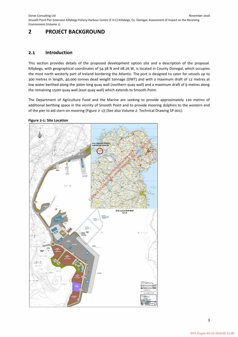
2 PROJECT BACKGROUND
2.1 Introduction
This section provides details of the proposed development option site and a description of the proposal.
Killybegs, with geographical coordinates of 54.38 N and 08.26 W, is located in County Donegal, which occupies
the most north westerly part of Ireland bordering the Atlantic. The port is designed to cater for vessels up to
300 metres in length, 40,000 tonnes dead weight tonnage (DWT) and with a maximum draft of 12 metres at
low water berthed along the 300m long quay wall (northern quay wall) and a maximum draft of 9 metres along
the remaining 150m quay wall (east quay wall) which extends to Smooth Point.
The Department of Agriculture Food and the Marine are seeking to provide approximately 120 metres of
additional berthing space in the vicinity of Smooth Point and to provide mooring dolphins to the western end
of the pier to aid stern on mooring (Figure 2-1)( (See also Volume 2: Technical Drawing SP 001).
Figure 2-1: Site Location
For
insp
ectio
n pur
pose
s only
.
Conse
nt of
copy
right
owne
r req
uired
for a
ny ot
her u
se.
EPA Export 03-12-2016:02:12:49

Doran Consulting Ltd November 2016
Smooth Point Pier Extension Killybegs Fishery Harbour Centre (F.H.C) Killybegs, Co. Donegal; Assessment of Impact on the Receiving
Environment (Volume 1)
4
2.2 Site History
The construction of the new harbour in 2004 provided facilities suitable for large deep sea trawlers, visiting
cruise liners and other commercial cargo vessels (see Photograph 1). The older harbour consisted of the
Landing Pier, the Town Pier, the slipway, the Blackrock Pier and the Department Shipyard (including a 600t
vessel lift facility) (Figure 2-2). These facilities were very busy all year round and together with the new pier
development, aimed to cater for the needs of medium to large vessels using the harbour. Most small vessels
either berthed alongside large vessels at the piers or used the swing moorings located between the Blackrock
Pier and the slipway.
Photograph 1 – Aerial View of 2004 Harbour Development (Source: Department of Agriculture, Food and the
Marine, Feasibility Study at Smooth Point, May 2015)
For
insp
ectio
n pur
pose
s only
.
Conse
nt of
copy
right
owne
r req
uired
for a
ny ot
her u
se.
EPA Export 03-12-2016:02:12:49

Doran Consulting Ltd November 2016
Smooth Point Pier Extension Killybegs Fishery Harbour Centre (F.H.C) Killybegs, Co. Donegal; Assessment of Impact on the Receiving
Environment (Volume 1)
5
Figure 2-2: Pre-2004 Harbour Layout
(Source: Killybegs Harbour Development Environmental Impact Statement (January 2001)
2.3 2004 Pier Construction
The 2004 harbour development in Killybegs provides facilities for the largest trawlers in Europe, visiting cruise
liners and other commercial cargo vessels. The development, completed in 2004, required the infilling of tidal
waters over an area of approximately 11 hectares. The footprint for the harbour development covered the tidal
waters between two small islands adjacent to the approaches to Killybegs, at Smooth Point and Rough Point
and the existing shoreline to the west (Photograph 2 and 3).
For
insp
ectio
n pur
pose
s only
.
Conse
nt of
copy
right
owne
r req
uired
for a
ny ot
her u
se.
EPA Export 03-12-2016:02:12:49

Doran Consulting Ltd November 2016
Smooth Point Pier Extension Killybegs Fishery Harbour Centre (F.H.C) Killybegs, Co. Donegal; Assessment of Impact on the Receiving
Environment (Volume 1)
6
Photograph 2 - Site Location
(Source: Killybegs Harbour Development Environmental Impact Statement (January 2001)
Photograph 3 - Aerial View of the Site Prior to the Harbour Development with Rough Point and Smooth Point adjacent to Syncrolift. (Source: Department of Agriculture, Food and the Marine, Feasibility Study at Smooth Point, May 2015)
Approximate Line of Existing Quay
For
insp
ectio
n pur
pose
s only
.
Conse
nt of
copy
right
owne
r req
uired
for a
ny ot
her u
se.
EPA Export 03-12-2016:02:12:49
Doran Consulting Ltd November 2016
Smooth Point Pier Extension Killybegs Fishery Harbour Centre (F.H.C) Killybegs, Co. Donegal; Assessment of Impact on the Receiving
Environment (Volume 1)
7
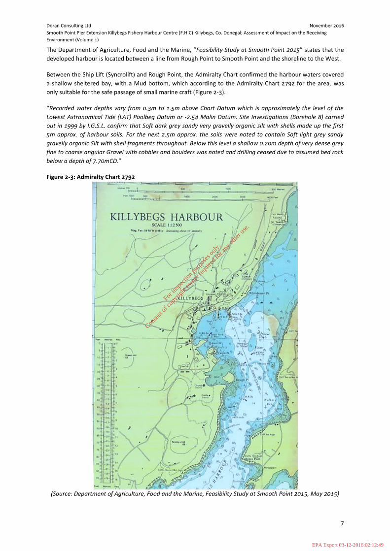
The Department of Agriculture, Food and the Marine, “Feasibility Study at Smooth Point 2015” states that the
developed harbour is located between a line from Rough Point to Smooth Point and the shoreline to the West.
Between the Ship Lift (Syncrolift) and Rough Point, the Admiralty Chart confirmed the harbour waters covered
a shallow sheltered bay, with a Mud bottom, which according to the Admiralty Chart 2792 for the area, was
only suitable for the safe passage of small marine craft (Figure 2-3).
“Recorded water depths vary from 0.3m to 1.5m above Chart Datum which is approximately the level of the
Lowest Astronomical Tide (LAT) Poolbeg Datum or -2.54 Malin Datum. Site Investigations (Borehole 8) carried
out in 1999 by I.G.S.L. confirm that Soft dark grey sandy very gravelly organic silt with shells made up the first
5m approx. of harbour soils. For the next 2.5m approx. the soils were noted to contain Soft light grey sandy
gravelly organic Silt with shell fragments throughout. Below this level a shallow 0.20m depth of very dense grey
fine to coarse angular Gravel with cobbles and boulders was noted and drilling ceased due to assumed bed rock
below a depth of 7.70mCD.”
Figure 2-3: Admiralty Chart 2792
(Source: Department of Agriculture, Food and the Marine, Feasibility Study at Smooth Point 2015, May 2015)
For
insp
ectio
n pur
pose
s only
.
Conse
nt of
copy
right
owne
r req
uired
for a
ny ot
her u
se.
EPA Export 03-12-2016:02:12:49

Doran Consulting Ltd November 2016
Smooth Point Pier Extension Killybegs Fishery Harbour Centre (F.H.C) Killybegs, Co. Donegal; Assessment of Impact on the Receiving
Environment (Volume 1)
8
During the 2004 development, the quay wall was formed using a tubular steel pile/ Larssen sheet pile
combined wall system with a reinforced concrete cast in-situ capping beam, precast concrete facing panels, tie
rods and sheet pile anchor wall. The quayside surface comprises a reinforced concrete deck slab along the
berthing quay finished to a level of 4.21m Malin Head or 6.55m Chart Datum. A short section of the Quay at the
shipyard end of Smooth Point was constructed using a rock armour revetment founded on the existing shore
level with the quay decking finished using a bitumen macadam running surface. At this location the Smooth
Point sediment bank remains in-situ. The historical maintenance of small fishing vessels has led to a degree of
contamination in this area. As a result the Smooth Point sediment bank was not removed during the 2004
project, primarily due to the potential costs associated with the dredging and disposal of any contaminated
sediments and other technical difficulties and time constraints.
2.4 Proposed Smooth Point Pier Extension
Due to the success of the 2004 harbour development, marine traffic associated with both commercial and the
fishing industry has increased significantly. Killybegs harbour now accommodates large cruise liners, service
vessels for the oil and gas industry, large scale delivery of wind farm components along with annual fish
landings from both foreign and Irish vessels.
As a consequence of this increased activity the demand for quayside berthing now exceeds available quay
space during peak periods. At present, due to depth restrictions caused by the existing sediment bank at
Smooth Point, approximately 80m of quayside is unusable. Smooth Point is clearly visible at low tide as can be
seen in Photograph 4 below.
Photograph 4 - Aerial View on Harbour Construction Works with Smooth Point Sand Bar (Source:
Department of Agriculture, Food and the Marine, Feasibility Study at Smooth Point, May 2015)
2.5 Description of the Proposed Development
The Smooth Point Extension will extend the existing quay wall by 120m in a north westerly direction across a
naturally occurring gravel spit known as Smooth Point. To create a berthing pocket of -9m CD it will be
necessary to remove smooth point and dredge silts, gravels and rock (Refer to Technical Appendix 2-1).
Smooth Point Sand Bar
For
insp
ectio
n pur
pose
s only
.
Conse
nt of
copy
right
owne
r req
uired
for a
ny ot
her u
se.
EPA Export 03-12-2016:02:12:49

Doran Consulting Ltd November 2016
Smooth Point Pier Extension Killybegs Fishery Harbour Centre (F.H.C) Killybegs, Co. Donegal; Assessment of Impact on the Receiving
Environment (Volume 1)
9
It is proposed that the rock will be brought ashore and stockpiled for future use, contaminated gravels and silts
will be disposed of to a licensed landfill and the clean gravel and silts disposed of to sea under licence from
EPA.
In total an estimated 128,500 m3 of bed material will be dredged from the Killybegs Harbour area, out of which
approximately 96,900 m3 will be disposed at the proposed dredge disposal site (Figure 2-4).
Figure 2-4: Location of proposed dredge disposal site (600m by 600m) in Donegal Bay 14km SW of Killybegs,
Co. Donegal.
The anticipated capital dredging campaign will last for potentially four weeks and continuous operation
represents a daily disposal volume of almost 6,000 tonnes. The disposal site is ca. 0.36km2 in area with depths
of ca. 70m below mean sea level. Table 2-1 presents a breakdown of the materials to be dredged;
Table 2-1: Summary of the Quantities of materials to be dredged
Material Quantity (m3)
Gravels forming Smooth Point (Class 1 or 2) 23,500
Silts (Class 1 & 2) 56,400
Silts (Class 3) 17,600
Gravel (Class 1 & 2) 17,000
Rock 14,000
Total volume to be dredged 128,500
Dredging: Silts & gravels not going to sea Circa. 17,600 m
3 of silts and gravels will be dredged from the dredge area which has been found to be
unsuitable for disposal at sea
• Some of this material can be excavated from land using a long reach excavator and placed directly into
dumper trucks for removal to the processing location within the site.
• The material which cannot be dredged from land will likely be dredged using an excavator mounted on
a barge and placed into a dump barge. This barge will be towed to the quay side and emptied by an
Disposal
Site
For
insp
ectio
n pur
pose
s only
.
Conse
nt of
copy
right
owne
r req
uired
for a
ny ot
her u
se.
EPA Export 03-12-2016:02:12:49

Doran Consulting Ltd November 2016
Smooth Point Pier Extension Killybegs Fishery Harbour Centre (F.H.C) Killybegs, Co. Donegal; Assessment of Impact on the Receiving
Environment (Volume 1)
10
excavator located on the quay and placed directly into dumper trucks for removal to the processing
location within the site.
Dredging: Silts & gravels going to sea The remaining 96,900m
3 of silts and gravels may be dredged by;
A long reach excavator mounted on a floating pontoon. The dredged material would be loaded
into either a split hopper barge to be towed to the disposal site or a self-propelled split hopper
barge which could steam to the sea disposal site by itself.
A trailer suction dredger could be utilised. In this instance the silt would be discharged directly
into a large sea going vessel for transport to the sea disposal site (final method to be confirmed
by the contractor).
At the licensed disposal site the dredged material will be released as a density flow to the seabed to minimise
turbidity.
It is proposed that all rock will be stockpiled within Killybegs FHC under agreement with EPA, for reuse on
future developments within the harbour.
According to the results of the granulometric analysis undertaken by Aquafact Ltd (Table 2-2) the material to be
dredged and disposed of offshore at the proposed disposal site consists of sandy mud, typically 5% clay, 59%
silt, 27% fine sand and 9% medium sand or coarser fractions (refer to Technical Appendix 5-1 for detailed
information).
Table 2-2: Granulometric analysis results of sediment samples collected at the proposed dredge area in
Killybegs Harbour, Co. Donegal.
The dredge working methods will be confirmed by the contractor, but are expected to consist of the methods
described below (combination thereof):
Suction Dredging
A Trailer Suction Hopper Dredger is suitable for removing granular, unconsolidated or softer material. This
vessel is equipped with one or two dragheads connected to the ship by a pipe, these are trailed along the sea
bed and a suction pump lifts sediment off the seabed, suspends it in water and draws the mixture up the pipe
into the vessel’s integral tank, or ‘hopper’. When the hopper is full, the vessel proceeds to the disposal ground
and opens doors along the keel to allow the mixture to be discharged. See Figure 2-5 below:
Particle Class particle size Killybegs Samples average median Adj. median
microns % % % % % % %
clay <4 3.0384 4.984 6.672 4.701 4.84885 4.8425 5.1
v fine silt 4 - 8 5.79 7.63 9.57 6.68 7.4175 7.155 7.5
fine silt 8 - 16 11.54 13 14.77 10.47 12.445 12.27 12.9
medium silt 16 - 31 18.85 17.26 18.57 13.35 17.0075 17.915 18.8
coarse silt 31 - 62 21.5 18.37 18.18 13.99 18.01 18.275 19.2
v fine sand 62 - 125 20.25 17.92 15.34 13.26 16.6925 16.63 17.5
fine sand 125 - 250 12.11 10.25 8.53 7.08 9.4925 9.39 9.9
medium sand 250 - 500 5.18 5.21 4.33 2.93 4.4125 4.755 5.0
coarse sand 500 - 1000 0.9824 1.661 1.048 0.39329 1.021173 1.0152 1.1
v Coarse Sand 1000 - 2000 0.367 1.58 1.125 4.92 1.998 1.3525 1.4
gravel >2000 0.3314 1.64 1.39 22.22 6.39535 1.515 1.6
Total % 99.9392 99.505 99.525 99.99429 99.74 95.12 100
For
insp
ectio
n pur
pose
s only
.
Conse
nt of
copy
right
owne
r req
uired
for a
ny ot
her u
se.
EPA Export 03-12-2016:02:12:49

Doran Consulting Ltd November 2016
Smooth Point Pier Extension Killybegs Fishery Harbour Centre (F.H.C) Killybegs, Co. Donegal; Assessment of Impact on the Receiving
Environment (Volume 1)
11
Figure 2-5: Typical Trailer Dredge set-up
Backhoe Dredging
Backhoe dredging is required to effectively remove ‘stiffer’ consolidated material like clay, as well as boulders
and weathered/weaker rock outcrops. It is also needed to remove the pre-treated bed rock after the drill and
blast process. Figure 2-6 shows the typical arrangement with a long reach excavator positioned on a barge; it
also shows the self-propelled disposal barge that is used to take the dredged material to the disposal ground.
The dredging barge is stabilised on spud legs, so it does not require anchors and can be easily and rapidly
moved. It is accurately positioned using a computer linked to a differential GPS system.
Figure 2-6: Backhoe Dredging set-up
1. Hopper
2. Suction Pipe
3. Draghead
2
3
For
insp
ectio
n pur
pose
s only
.
Conse
nt of
copy
right
owne
r req
uired
for a
ny ot
her u
se.
EPA Export 03-12-2016:02:12:49

Doran Consulting Ltd November 2016
Smooth Point Pier Extension Killybegs Fishery Harbour Centre (F.H.C) Killybegs, Co. Donegal; Assessment of Impact on the Receiving
Environment (Volume 1)
12
2.5.1 Harbour Wall Design
The works will include the provision of 53m of new combi wall, comprising 1067mm dia. (subject to detailed
design) steel tubular piles with infill sheet piles, in the location of the existing stone revetment. 67m of existing
combi wall will be strengthened to accommodate the extension of the -9mCD dredge pocket (110m in total)
(Refer to Volume 2: Drawings and Figures).
2.5.2 Form of Previous Quay Wall Construction.
1067 x 25.4mm tubular steel piles @ 2910mm centres with 3 No Larssen LX32 Sheet Piles fixed between each
tube to form the quay wall, with M105 Tie Bar connecting each tubular pile to a secondary Larssen LX20 Sheet
Pile Anchor Wall, installed 30m within harbour site, parallel to the outer quay wall installation.
2.5.3 Form of Proposed Quay Wall Construction.
The construction of the proposed quay wall will be constructed very similar to the existing quay wall. Tubular
steel piles with steel sheet piles between each tube will form the quay wall. Stability to the wall will be
provided by tie rods anchored to a buried sheet pile wall beneath the hinterland behind the new wall.
2.5.4 Length of Proposed Quay Wall Extension.
The existing quay wall will be extended by approximately 120m in the same alignment as the existing quay. See
Volume 2: Technical Drawing SP-001.
2.5.5 Proposed Deck Level.
The proposed finished deck level will match that of the existing quay i.e. 6.55mCD (4.21m OD Malin).
2.5.6 Proposed Dredged Level of berthing Pocket.
The area to the front of the new quay wall will require dredging to create a berthing pocket of -9.00m to the
front. This bed level will increase to -7m CD approximately 120m from the quay wall to tie into the navigable
shipping channel. From the existing site investigations an estimated figure of 128,500 cu.m. of material will be
dredged to allow clear access to and from this section of the harbour channel.
2.5.7 Breasting Dolphins
3 No breasting dolphins will be constructed perpendicular to the northern end of the quay to facilitate stern on
berthing of fishing vessels. The breasting dolphins will comprise a concrete deck, measuring approximately 8 x
5 x 2m (subject to detailed design), supported on 6No. 1067mm dia. (subject to detailed design) tubular steel
piles. Rock sockets and strand anchors will provide fixity to the rock. Each Dolphin will be fitted with 1No. cone
fender on the south elevation and 2No. timber rubbing strips on the north elevation, and walkways spanning
between the deck for access.
Preliminary construction sequence includes;
Tubular steel piles will be driven through the gravel and silt layers and socketed into the rock strata
below. This will be carried out by means of top rock socket drilling.
For
insp
ectio
n pur
pose
s only
.
Conse
nt of
copy
right
owne
r req
uired
for a
ny ot
her u
se.
EPA Export 03-12-2016:02:12:49

Doran Consulting Ltd November 2016
Smooth Point Pier Extension Killybegs Fishery Harbour Centre (F.H.C) Killybegs, Co. Donegal; Assessment of Impact on the Receiving
Environment (Volume 1)
13
Strand anchors will be drilled and constructed beyond the pile toe level, extending to the capping
beam.
A reinforced concrete deck will be cast and strand anchors tensioned.
A steel split sleeve collar will be constructed to facilitate connection of the lower fender cone on the
south elevation and extension of. Grout will be placed between the split sleeve collar and tubular pile
to provide a connection. The upper fender cone will be fixed to the 2m deep concrete deck. Timber
rubbing strips will be
Steel catwalks will be installed between the dolphins to provide access/egress.
2.5.8 Proposed Site Works
The existing rock armour revetment (Photograph 5) will be removed and set aside on site for reuse within the
harbour. All piling activity would proceed from the existing harbour deck, clear of the tidal water. The piles to
form the new quay wall will be placed through driving and rock coring techniques. Following completion of the
quay wall the gravel forming Smooth Point will be removed and the bed materials dredged and disposed of in a
responsible manner.
Photograph 5- Rock Armour Sea Wall at Smooth Point (Source: Department of Agriculture, Food and the
Marine, Feasibility Study at Smooth Point, May 2015).
As previously noted above, the existing bed rock profile at approximately -5.30mCD would need to be moved.
It is expected that the rock will be removed using suitable mechanical plant however it may be necessary to
blast rock should it be found to be stronger than indicated by the Site Investigation. Due to the close proximity
of the nearby Synchrolift structure, vibration will be closely monitored and controlled.
2.6 Consideration of Alternatives
The quay extension could not practically be implemented in a different location to the same effect.
The disposal ground location was investigated by AQUAFACT and their report ‘Site selection process for the
disposal of dredge spoil from Killybegs Harbour to a location in Donegal Bay’ of September 2016 is contained in
Technical Appendix 2.2. This report concluded that the existing disposal site would be suitable.
For
insp
ectio
n pur
pose
s only
.
Conse
nt of
copy
right
owne
r req
uired
for a
ny ot
her u
se.
EPA Export 03-12-2016:02:12:49

Doran Consulting Ltd November 2016
Smooth Point Pier Extension Killybegs Fishery Harbour Centre (F.H.C) Killybegs, Co. Donegal; Assessment of Impact on the Receiving
Environment (Volume 1)
14
3 SCOPING OUTCOME
3.1 Scoping the Assessment of Impact on the Receiving Environment
In April 2016 a Scoping Report was submitted to Donegal County Council. The key objective of the Scoping
Report was to engage with the relevant Statutory and Non‐Statutory Consultees to: obtain their views on the
project; identify potential impacts; identify existing environmental information; and agree methods for the
assessment of the nature and significance of these impacts, thus ensuring that all relevant environmental
issues were covered by the AIRE. Furthermore, the scoping process enables the topics to be covered in the
AIRE to be agreed and for those topics not considered pertinent to be scoped out or reduced in scope (i.e. not
meriting a full chapter).
At the time of producing the AIRE, no formal consultation responses have been received; nevertheless, a
degree of consultation has been undertaken as part of the design process and is described below.
3.2 Consultation
3.2.1 Donegal County Council: Planning
In addition to the formal Scoping Report process, Doran Consulting met with Mr Cillian Smith the local planning
officer to discuss the proposed project. Mr Smith was receptive to the scheme. Mr Smith stated that the
Planning submission should be accompanied by;
Proposed drawings including a cross section of the dredge pocket, new wall and hinterland extending
back to the hill behind the harbour;
The location of any planned rock stockpiles including location and cross sections;
Confirmation that the rock generated by the dredging process and to be stockpiled is a resource and
not a waste (i.e. Article 27 Declaration from EPA);
Chemical Analysis of the sediments to be dredged;
Method statements for how the rock will be dredged;
Historic and current Archaeological reports on Smooth Point;
Ecological impacts associated with the proposed development require to be assessed;
Habitats Regulations Assessment;
Statement for mitigation of any identified impacts on St John’s Point SAC; and
Details of proposed noise and dust control measures to be put in place during the works.
Donegal County Council planning department concluded that a full AIRE section would not be required for
traffic and transport.
3.2.2 Dumping at Sea Licence from EPA
Doran Consulting have been in correspondence with Margot Cronin of the Marine Institute to discuss their
requirements for chemical testing of the material to be disposed of to sea. Margot confirmed these
requirements and Aquafact collected the required samples and arranged for the required testing. Consultation
with key stakeholders in the Disposal at Sea licensing process have begun.
For
insp
ectio
n pur
pose
s only
.
Conse
nt of
copy
right
owne
r req
uired
for a
ny ot
her u
se.
EPA Export 03-12-2016:02:12:49

Doran Consulting Ltd November 2016
Smooth Point Pier Extension Killybegs Fishery Harbour Centre (F.H.C) Killybegs, Co. Donegal; Assessment of Impact on the Receiving
Environment (Volume 1)
15
3.2.3 Article 11 Declaration from EPA
Dearn McClintock of Donegal County Council (DCC) confirmed that DCC would defer to EPA on the issue of the
rock generated from the dredging process being a resource or a waste.
Doran Consulting subsequently spoke to Brian Meaney of EPA who has confirmed that an Article 11 declaration
should be submitted to EPA for the proposed stockpile of rock.
3.3 Scope of the AIRE
Based on best practice and professional experience, a view was reached on the key topics to be assessed and included as a full impact assessment chapter as part of the AIRE. These were:
Planning;
Water Environment;
Ecology;
Noise; and
Underwater Archaeology.
On the basis of professional judgement and review of baseline conditions, full impact assessment is not
considered necessary for the following topics, the rationale for which is provided below:
• Air Quality;
• Geology, Soils and Contaminated Land; and
• Landscape and Visual;
• Traffic and Transport; and
• Vibration (Terrestrial).
A summary of the reasons why these topics have been discounted from full impact assessment as well as a
brief overview of the findings of each desk based assessment are provided below.
Air Quality
The site currently operates as a harbour facility which would remain relatively unchanged post construction.
The main impact on air quality is considered to occur during the construction phase when fugitive dust can be
generated through construction activities. The procedures to minimise dust arising’s can be addressed through
a Construction Environmental Management Plan (CEMP).
Geology, Soils and Contaminated Land
No geological designations are known to be present on the site or its surrounds. Previous site investigation information available indicates that there are not anticipated to be any significant effects on geology or soils.
The principal potential environmental impacts would be associated with the construction phase and the possible release of potential contaminants during dredging and disposal of sediments. The transport mechanism for such a release will be assessed within the Water Chapter of the AIRE based on site investigation information.
Landscape & Visual
The site is located within the Killybegs Harbour estate. The proposed development is not expected to be sensitive in terms of visual impact as works will be at the level of the existing quay.
For
insp
ectio
n pur
pose
s only
.
Conse
nt of
copy
right
owne
r req
uired
for a
ny ot
her u
se.
EPA Export 03-12-2016:02:12:49

Doran Consulting Ltd November 2016
Smooth Point Pier Extension Killybegs Fishery Harbour Centre (F.H.C) Killybegs, Co. Donegal; Assessment of Impact on the Receiving
Environment (Volume 1)
16
The proposed development site is not highly visible and views are likely to be similar to existing views (Figure 4-2). There are no significant ground features on completion of the project and no changes in landscape character from existing. The mooring dolphins and pontoons are also similar in character to existing ones.
The site is located next to large buildings owned by Mooneys Boat Yard. Land bordering the site rises to the west and are moderately planted with deciduous woodland tree species.
There are several residential properties at a high level north west of the harbour which face approximately east onto the bay with views over Killybegs Harbour.
The Smooth Point Extension will continue and extend the existing 2004 vertical quay wall (Rotary Core / Larssen Piling System) at Smooth Point, approximately 50m in length, remove tidal spoil by dredging to approximately -9m CD east of harbour and retain existing rock armour sea wall parallel to Syncrolift. The existing rock armour fronting the sand bar would be removed and set aside on site for further use with ongoing maintenance work at the harbour.
The scale of the proposed Smooth Point Pier extension is not significant relative to the existing harbour. When the proposed scheme is viewed from Binroe headland on the opposite shore of Killybegs Harbour the reduction in scale caused by the distances involved create a reduction in visual impact. Accordingly, it is not considered that the proposed development will have a significant environmental impact in terms of visual impact. The proposed development is set within an existing built up area and the proposed extension will not appear out of place in terms of their location, massing or height.
It is considered that given the type of works to be undertaken and the scale of works within the harbour setting that a full detailed landscape and visual assessment is not required.
Traffic and Transport
The proposal to upgrade the existing Killybegs Harbour and associated Vessel Berths provides opportunities to maximise the use of the existing infrastructure at the Harbour. It is considered that the proposed development is consistent with objectives set out in the national and regional documents for sustainable developments.
The local road network, particularly Shore Road, will not be unduly affected by the additional HGV traffic generated during the construction phase.
The existing roads and junctions in Killybegs are capable of coping with the increase in traffic expected as a result of the harbour development, it is unlikely that the increase in a significant impact with regard to air quality.
Initial consultation between Doran Consulting and the Local Authority determined that the effects in relation to the environment from road traffic will be negligible. Additional traffic during the construction phase and the day to day operation of the development are unlikely to unduly affect the noise levels or air quality in the area. It is therefore considered that there will be no adverse impacts on the environment in relation to traffic. Traffic and Transport and associated impacts are therefore scoped out of the Assessment of Impact on the Receiving Environment.
Vibration (Terrestrial)
The aspects to be considered from vibration impacts would be; the effects on people or equipment within
buildings and the effect on buildings (or other structures) themselves. The most common form of vibration
associated with construction is that from piling, which produces an intermittent type derived from
conventional driven piling. Due to the proximity of the eastern section of the site to residential properties as
well as the presence of buildings on site and within the immediate vicinity of the harbour, there is potential for
construction activities, especially piling, to have an impact. The criterion set out in Table 4-1 relates to the
effects of piling or similar construction activities on buildings and other structures. In most situations, although
cosmetic damage may be possible to buildings located within 20m from piling activities, at greater distances
For
insp
ectio
n pur
pose
s only
.
Conse
nt of
copy
right
owne
r req
uired
for a
ny ot
her u
se.
EPA Export 03-12-2016:02:12:49
Doran Consulting Ltd November 2016
Smooth Point Pier Extension Killybegs Fishery Harbour Centre (F.H.C) Killybegs, Co. Donegal; Assessment of Impact on the Receiving
Environment (Volume 1)
17
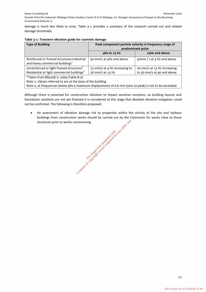
damage is much less likely to arise. Table 3-1 provides a summary of the research carried out and related
damage thresholds.
Table 3-1: Transient vibration guide for cosmetic damage
Type of Building
Peak component particle velocity in frequency range of predominant pulse
4Hz to 15 Hz 15Hz and above
Reinforced or framed structures Industrial and heavy commercial buildings
1
50 mm/s at 4Hz and above 50mm / s at 4 Hz and above
Unreinforced or light framed structures2
Residential or light commercial buildings2
15 mm/s at 4 Hz increasing to 20 mm/s at 15 Hz
20 mm/s at 15 Hz increasing to 50 mm/s at 40 and above
*Taken from BS5228-2: 2009 (Table B.2) Note 1, Values referred to are at the base of the building Note 2, at frequencies below 4Hz a maximum displacement of 0.6 mm (zero to peak) is not to be exceeded.
Although there is potential for construction vibration to impact sensitive receptors, as building layouts and
foundation solutions are not yet finalised it is considered at this stage that detailed vibration mitigation could
not be confirmed. The following is therefore proposed:
An assessment of vibration damage risk to properties within the vicinity of the site and harbour
buildings from construction works should be carried out by the Contractor for works close to those
structures prior to works commencing.
For
insp
ectio
n pur
pose
s only
.
Conse
nt of
copy
right
owne
r req
uired
for a
ny ot
her u
se.
EPA Export 03-12-2016:02:12:49

Doran Consulting Ltd November 2016
Smooth Point Pier Extension Killybegs Fishery Harbour Centre (F.H.C) Killybegs, Co. Donegal; Assessment of Impact on the Receiving
Environment (Volume 1)
18
4 PLANNING CONTEXT
4.1 Planning Policies
As part of the AIRE a review of planning policies was undertaken to determine whether or not the proposed
extension to Killybegs Harbour is consistent with the objectives and policies of the local, county and regional
development plans in terms of their views on sustaining and developing the harbour at Killybegs, County
Donegal and the border region.
The County and Town Development Plans are placed within a hierarchy of other plans detailed below and as
such the policies and objectives of the plans must accord with the National Spatial Strategy (2002) and Border
Regional Planning Guidelines (2010-2022) (Table 4-1).
Table 4-1: Hierarchy of Plans
National Spatial Strategy 2002
Border Regional Planning Guidelines 2010-2022
County Donegal Development Plan 2012-2018
Town Development Plans
The National Spatial Strategy (NSS) 2002 sets out the strategic vision for the spatial development of the
Country over a 20 year period, and identifies County Donegal as a distinct sub-region with the border region.
The Border Regional Planning Guidelines 2010-2022 builds on the provision of the NSS by providing for a
succinct settlement hierarchy throughout the County based on the Core Strategy requirements of the Planning
and Development Acts 2010. They set out a clear planning framework for growth in the County by setting out
population targets which will inform settlement and housing strategies in addressing the proper planning and
sustainable development of the County.
County Donegal Development Plan 2012-2018 Plan is the principle instrument that is used to manage land use
change within the County and the Plan accompanying this Environmental Report consists of a written
document containing the objectives and policies of the Plan, maps and appendices.
Town Development Plans (Local Area Plan) is a statutory land use planning document and map(s) (consistent
with the objectives of the County Development Plan) detailing policies and objectives to ensure the proper
planning and sustainable development of the town.
The Plans, provide a detailed and consistent framework for the determination of all planning applications. It
will also guide and anticipate land-use developments in a controlled and sustainable way, enabling the local
authority to focus resources and infrastructural improvements where they are most needed.
For
insp
ectio
n pur
pose
s only
.
Conse
nt of
copy
right
owne
r req
uired
for a
ny ot
her u
se.
EPA Export 03-12-2016:02:12:50

Doran Consulting Ltd November 2016
Smooth Point Pier Extension Killybegs Fishery Harbour Centre (F.H.C) Killybegs, Co. Donegal; Assessment of Impact on the Receiving
Environment (Volume 1)
19
County Donegal Development Plan 2012-2018 Plan
The County Donegal Development Plan 2012-2018 highlights the following key issues that are pertinent to the
proposed Smooth Point Pier Extension at Killybegs harbour.
AH-P-1 It is a policy of the Council to protect and enhance the integrity of Archaeological Monuments and
their settings and to secure the preservation in-situ of all archaeological monuments included in the Record of
Monuments and Places.
AH-P-2 It is the policy of the Council to conserve and protect Zones of Archaeological Potential located in the
urban areas of Ballyshannon, Donegal Town, Killybegs, Lifford, Ramelton, Rathmullan and St. Johnston as
identified in the Record of Monuments and Places.
AH-P-3 It is the policy of the Council to protect the character, settings of and views from National
Monuments/ Recorded Monuments and to manage development which would be considered to (visually or
physically) intrude upon or inhibit the enjoyment of the amenities of these sites. AH-P-4 It is a policy of the
Council to protect where appropriate, the character and setting of any unrecorded archaeological object or
site.
ED-P-16 It is a policy of the Council that any proposal for economic development use, in addition to other
policy provisions of this Plan, will be required to meet all the following criteria;
(a) it is compatible with surrounding land uses existing or approved; (b) it does not harm the amenities of nearby residents; (c) there is existing or programmed capacity in the water infrastructure (supply and/or effluent
disposal) or suitable developer-led improvements can be identified and delivered; (d) the existing road network can safely handle any extra vehicular traffic generated by the proposed
development or suitable developer-led improvements are identified and delivered to overcome any road problems;
(e) adequate access arrangements, parking, manoeuvring and servicing areas are provided in line with standards set out in Appendix B or as otherwise agreed in writing with the planning authority;
(f) it does not create a noise nuisance; (g) it is capable of dealing satisfactorily with any emission(s); (h) it does not adversely affect important features of the built heritage or natural heritage including
Natura 2000 sites; (i) it is not located in an area at flood risk and/or will not cause or exacerbate flooding; (j) the site layout, building design, associated infrastructure and landscaping arrangements are of
high quality and assist the promotion of sustainability and biodiversity; (k) appropriate boundary treatment and means of enclosure are provided and any areas of outside
storage proposed are adequately screened from public view; (l) in the case of proposals in the countryside, there are satisfactory measures to assist integration
into the landscape; (m) it does not compromise water quality nor the programme of measures contained within the
North Western River Basin (NWIRBD) Management Plan 2009-2015.
E-P-5 It is a policy of the Council to become a centre of excellence for research and development of renewable
energy technologies including wind, hydro, tidal and wave and specifically to facilitate the development of
Killybegs harbour [and Donegal Airport] as maintenance, service and supply centres for offshore energy
facilities in the context of other objectives and policies of this Plan.
F-P-1 It is a policy of the Council to ensure that all development proposals comply with ‘The Planning System
and Flood Risk Management - Guidelines for Planning Authorities’, November 2009, DoEHLG.
For
insp
ectio
n pur
pose
s only
.
Conse
nt of
copy
right
owne
r req
uired
for a
ny ot
her u
se.
EPA Export 03-12-2016:02:12:50

Doran Consulting Ltd November 2016
Smooth Point Pier Extension Killybegs Fishery Harbour Centre (F.H.C) Killybegs, Co. Donegal; Assessment of Impact on the Receiving
Environment (Volume 1)
20
F-P-4 It is a policy of the Council to employ a precautionary principle using the sequential approach towards
development proposals where there is a known flood risk and to make best use of the available information
including the Flood Risk Indicators, unless it is fully justified (see F-P-7) that there are wider sustainability
grounds for appropriate development and the flood risk can be managed to an acceptable level without
increasing flood risk elsewhere and where possible, reducing flood risk overall.
F-P-5 It is a policy of the Council to require applicants/developers to submit, where appropriate, independent
‘Flood Risk Assessment’ in accordance with the Flood Risk Management Guidelines, DEHLG, 2009 (or as
updated) and/or ‘Surface Water Drainage Calculations’, from suitably qualified persons.
G-P-1 It is a policy of the Council to protect County Geological Sites (CGS). Accordingly the Council will adopt a
precautionary approach to development proposals with the potential to impact upon a CGS. Proposals should
be accompanied by a detailed report from a competent person setting out the potential impact to ensure that
an informed decision can be made. Where significant harm to the CGS is deemed likely, planning permission
will not be granted unless there are overriding considerations of public importance to the County.
MCZM-P-4 It is a policy of the Council to facilitate the appropriate development and upgrade of marina, boat
stations and/or sea angling facilities throughout the County, including the offshore islands.
Ballyhoorisky, Bunagee (Culdaff), Burtonport, Fahan, Killybegs and Tory Island are priority areas for the
development of marinas and associated ancillary infrastructure but potential projects at other locations that
will encourage tourism will also be considered.
MCZM-P-7 It is a policy of the Council to safeguard and enhance the roles of Killybegs, Greencastle,
Burtonport, Downings and Rathmullan as centres of fleet activity, processing and ancillary services, and, to
facilitate the diversification of such locations into new areas of appropriate investment and employment
opportunities, including marine related economic activity, that accords with the proper planning and
sustainable development of the area.
MCZM-P-8 It is a policy of the Council to facilitate the development of Killybegs as a Centre of Excellence for
training, research and development, transit and logistics, manufacture and retrofit of renewable and other
offshore energies, in the context of the proper planning and sustainable development of the area.
NH-P-1 It is a policy of the Council to ensure development proposals do not damage or destroy any sites of
international or national importance, designated for their wildlife/habitat significance.
NH-P-2 It is a policy of the Council to ensure the protection of Natura 2000 sites in accordance with the EU
Habitats Directive (92/43/EEC) and have regard to the relevant conservation objectives, qualifying interests and
threats to the integrity of these Natura 2000 sites.
NH-P-3 It is a policy of the Council to require the consideration of Designated Shellfish Waters and their
Shellfish Pollution Reduction Programmes in all development proposals that fall within their catchment.
NH-P-5 It is a policy of the Council to require consideration of the impact of potential development on
habitats of natural value that are key features of the County’s ecological network and to incorporate
appropriate mitigating biodiversity measures into development proposals.
NH-P-6 It is the policy of the Council to safeguard the scenic context, cultural landscape significance,
recreational and environmental amenities of the County’s coastline from inappropriate development.
NH-P-10 It is a policy of the Council to protect landscapes of Especially High Scenic Amenity (EHSA) and views
and prospects and to preserve the character of distinctive regional, local and cultural landscapes in the County.
For
insp
ectio
n pur
pose
s only
.
Conse
nt of
copy
right
owne
r req
uired
for a
ny ot
her u
se.
EPA Export 03-12-2016:02:12:50

Doran Consulting Ltd November 2016
Smooth Point Pier Extension Killybegs Fishery Harbour Centre (F.H.C) Killybegs, Co. Donegal; Assessment of Impact on the Receiving
Environment (Volume 1)
21
T-P-26 It is a policy of the Council to promote and facilitate the further development and expansion of Killybegs
Harbour Centre as a strategically important deep water commercial and leisure port, subject to environmental
considerations.
TOU-P-6 It is a policy of the Council to enhance facilities and attractions for the development of the cruise ship
market in Killybegs in accordance with the proper planning and sustainable development of the area.
TOU-P-10 It is a policy of Council to permit appropriate proposals for extensions to existing
approved/authorised multiple static caravan/mobile home parks where any such extension does not negatively
impact on existing designated Natura 2000’s, EHSA’s, or area protected under the North West International
River Basin District Plan or conflicts with any other objective or policy of this Plan.
Objective CS-O-9 To support economic growth in the county at key locations of strategic and infrastructural
importance as well as high level, large employment generating growth in the Gateway. This will be achieved
through:
C) The establishment of the tier 2 settlements of Killybegs and Bridgend as key growth centres for new
economic activity. Focus in Killybegs will be in relation to the fisheries and associated industries, harbour
related, tourism, oil exploration and as a centre of excellence for renewables and services including
investigating the potential of establishing a Strategic Development Zone under Part IX of the Acts for
appropriate areas in Killybegs. In the case of Bridgend, the Council recognises the strategic cross border
location of Bridgend on the strategic transportation corridor connecting the linked Gateway of Letterkenny-
Derry and the opportunities that arise from the positioning of Project Kelvin. This together, with the substantial
supply of zoned land in the Northern Ireland jurisdiction (described as H1 and H2 residential zonings in the
Derry Area Plan 2011) position Bridgend as a location of economic growth, and for only limited growth of new
residential development.
Accessibility to Tourism
Killybegs harbour offers a unique opportunity for tourism in the North West as it enables cruise ships to berth
overnight. Between 2010 and 2011, 6 cruise vessels chose Killybegs as a destination. Greencastle has promoted
this sector for the past number of years. The Council recognises that this is a unique opportunity for Killybegs
or Greencastle to establish a niche market, which could sustain a seasonal Cruise Ship Centre.
Killybegs Local Area Plan 2008 – 2014 (Expired)
Section 2.5.4 Harbour/Port Related states “The Council recognises the importance of clusters for fishing related
socio-economic activity centred on Killybegs (Greencastle and Burtonport). Such centres act as vital economic
catalysts for their respective local economies and the achievement of critical mass is essential for future
development. Consequently the Council are committed to safeguarding the role of Killybegs as a centre of fleet
activity, processing and ancillary services.
It is a policy of the Council to:
HP 1 Safeguard and enhance the role of Killybegs, as a centre of fleet activity, processing, and ancillary services
and to promote the diversification of such locations into new areas of marine related economic activity.
HP 2 Promote the development of a strong and prosperous fishing industry and associated land use activities
capable of adapting to changing markets and supporting the communities that depend thereon.
HP 3 Facilitate the development of a Fisherman’s Wharf along the Old Pier with shops and restaurants that
promote a strong Maritime ethos.
For
insp
ectio
n pur
pose
s only
.
Conse
nt of
copy
right
owne
r req
uired
for a
ny ot
her u
se.
EPA Export 03-12-2016:02:12:50
Doran Consulting Ltd November 2016
Smooth Point Pier Extension Killybegs Fishery Harbour Centre (F.H.C) Killybegs, Co. Donegal; Assessment of Impact on the Receiving
Environment (Volume 1)
22
HP 4 Facilitate the development of a Marina, Boat Station and ancillary infrastructure for Sea Angling within
the inner harbour area.
NE 4 To protect and maintain the sensitive environmental habitat of the estuary identified as Area of Local
Nature Conservation. This area shall be maintained and enhanced to provide a high quality environmental
image along a major approach route to the town, the development of a public pedestrian / cycleway around
this estuary shall be promoted.
TMR 2 Facilitate developments that support the tourist economy.
TMR 5 Encourage the development of the cruise ship market in Killybegs by providing a range of facilities and
attractions, thereby encouraging the development of a sustainable tourism market in the area.
4.2 Conclusion
The Planning Policy framework is an iterative process, subject to change through revisions to Strategic and
Local Development Plans. It is consequently only possible to consider the impacts in terms of Planning Policy
against the policies in force at the time of assessment. In this respect the policies in force at the different
construction and operational phases are considered to be the same.
The potential impacts in relation to specific topic areas, such as ecology, noise, etc., are considered in the
relevant chapters.
The proposed extension to Killybegs Harbour is consistent with the objectives and policies of the local, county
and regional development plans in terms of their views on sustaining and developing the harbour at Killybegs,
County Donegal and the border region. The Smooth Point Pier Extension and deepening of the harbour will
allow Killybegs to:
Develop the cruise ship market by providing a range of facilities and attractions, thereby encouraging
the development of a sustainable tourism market in the area;
Safeguard and enhance the role of Killybegs, as a centre of fleet activity, processing, and ancillary
services and promoting diversification into new areas of marine related economic activity;
The establishment of new economic activity. Focus in Killybegs will be in relation to the fisheries and
associated industries, harbour related, tourism, oil exploration and as a centre of excellence for
renewables and services; and
Development of renewable energy technologies including wind, hydro, tidal and wave and specifically
to facilitate the development of Killybegs harbour as maintenance, service and supply centres for
offshore energy facilities in the context of other objectives and policies of this Plan.
For
insp
ectio
n pur
pose
s only
.
Conse
nt of
copy
right
owne
r req
uired
for a
ny ot
her u
se.
EPA Export 03-12-2016:02:12:50

Doran Consulting Ltd November 2016
Smooth Point Pier Extension Killybegs Fishery Harbour Centre (F.H.C) Killybegs, Co. Donegal; Assessment of Impact on the Receiving
Environment (Volume 1)
23
5 WATER ENVIRONMENT
5.1 Context
The water environment is considered to encompass coastal processes, hydrology and water quality. This
chapter of the AIRE will therefore address all of these subject areas.
The Water Framework Directive (WFD) (Council Directive 2000/60/EC) aims to protect and enhance water
bodies within Europe and covers all estuarine and coastal waters out to 1 nautical mile. This requires that there
is no deterioration in the quality of surface or groundwater bodies and aims to achieve good ecological status
or potential. The implications of the WFD must be considered when assessing this project and the details of
how compliance will be achieved provided in the AIRE.
The development proposals for the pier extension have the potential to cause changes to the baseline
hydrological conditions at the site, and in the wider area. Given the importance of the water environment as a
valued resource, and the importance of ensuring sustainable development, an assessment of coastal processes,
hydrology and water quality is considered essential.
The assessment will identify sensitive issues within the site by establishing the current baseline and examining
the proposed development option design within this context.
The natural deep water inlet of Killybegs Harbour is located to the north of McSwyne's Bay on the northern
shore of Donegal Bay, approximately 21km (13 miles) west of Donegal. The location and character of this inlet
makes it one of the safest and most sheltered deep water harbours on the Irish coast, extending approximately
4 km in length with an area of circa 10 km2.
5.2 Assessment Methodology
5.2.1 Legislation and Guidance
The assessment for the water environment will be based upon the following legislation and guidance;
• Directive 2000/60/EC of the European Parliament and of the Council establishing a framework for the
Community action in the field of water policy (The Water Framework Directive (WFD));
• The Groundwater Directive 2006/118/EC;
• European Communities (Water Policy) Regulations (2003) (as amended (most recently by S.I. No. 350
of 2014));
• The Surface Water Regulations, 2009;
• European Communities Environmental Objectives (Groundwater) Regulations, 2010;
• Donegal Bay Water Management Plan (2002);
• Working Together: The North Western International River Basin District (2008);
• The River Basin Management Plan for the North Western International River Basin District (RBMP)
2009-2015.
For
insp
ectio
n pur
pose
s only
.
Conse
nt of
copy
right
owne
r req
uired
for a
ny ot
her u
se.
EPA Export 03-12-2016:02:12:50

Doran Consulting Ltd November 2016
Smooth Point Pier Extension Killybegs Fishery Harbour Centre (F.H.C) Killybegs, Co. Donegal; Assessment of Impact on the Receiving
Environment (Volume 1)
24
5.2.2 Methodology
The components of the assessment are as follows:
Desk based review of the design of the proposed development in relation to the local water
environment;
Consultation with key stakeholders to obtain relevant information and to ensure their concerns are
addressed within the study;
Baseline assessment
o Review topography and ground conditions at the site and environs;
o Review of hydrology, catchment characteristics, and water quality conditions;
o Review of coastal processes including bathymetry, tidal levels, river and tidal flow currents,
wave action, surge and funnelling, bed sediment type and distribution, sediment transport
and deposition; and
o Reporting of baseline conditions to provide a basis for assessment of the potential impact.
• Impact assessment
o Identification of sensitive receptors and environmental constraints;
o Identification of potential impacts;
o Assessment of impact significance during Construction Phase and Operational
Phase;
o Identification and assessment of mitigation measures to reduce or avoid any
potential impacts of the proposed development; and
o Statement of residual impacts.
Assessment of the potential for particulate and chemical contamination of water will be central to the
assessment. The prevention of pollution during construction and operational phases will be a specific focus of
the AIRE and recommendations made for the adoption of good working practices in line with appropriate
guidance.
The proposed development will be considered in light of potential flood risk.
Potential impacts arising from the development will be predicted and evaluated by comparison with
environmental quality standards, sediment quality standards, and water and sediment quality objectives. The
observed baseline data will initially be used along with expert opinion to qualitatively assess the potential
impacts and the significance to receptors.
5.2.3 Consultation Outcomes
Consultation responses are detailed in Chapter 3 of this AIRE.
5.2.4 Assessment Criteria
The assessment criteria set out in Table 5-1 and Table 5-2 have been used to develop a matrix to assess the
significance of impacts from the proposed development on the local water environment (Table 5-3).
For
insp
ectio
n pur
pose
s only
.
Conse
nt of
copy
right
owne
r req
uired
for a
ny ot
her u
se.
EPA Export 03-12-2016:02:12:50

Doran Consulting Ltd November 2016
Smooth Point Pier Extension Killybegs Fishery Harbour Centre (F.H.C) Killybegs, Co. Donegal; Assessment of Impact on the Receiving
Environment (Volume 1)
25
Table 5-1: Criteria for assessing impact magnitude
Definition Impact Magnitude
Negligible Very light change from baseline conditions. Change barely distinguishable,
approximating to the ’no change’ situation.
Low Minor shift away from baseline conditions. Change arising from the loss/alteration
will be discernible but underlying character/composition/attributes of the baseline
condition will be similar to pre-development circumstances/patterns.
Medium Loss or alteration to one or more key elements/features of the baseline conditions
such that post-development character/ composition/ attributes of baseline will be
partially changed.
High Total loss or major alteration to key elements/features of the baseline (pre-
development) conditions such that post-development
character/composition/attributes will be fundamentally changed.
Table 5-2: Criteria for assessing receptor sensitivity
Receptor Sensitivity Description
Low Characteristics and features that do not make a significant contribution to the local
regime or are already altered from natural conditions.
Medium Natural features or characteristics that are of local importance.
High High value natural features or characteristics that are of regional importance or
sensitive to small scale change.
Table 5-3: Impact significance matrix
Sensitivity of Receptor Magnitude of Impact Predicted Effect
High High High
High Medium
Medium High
High Low Medium
Low High
Medium Medium
Medium Low Low
Low Medium
Low Low
High, Medium or Low Negligible Negligible
5.3 Baseline Conditions
5.3.1 Site Description
The proposed development site is situated to the north-western end of the existing Killybegs Harbour Pier, at
Smooth Point. Smooth Point is a sediment bar truncated by the existing rock armour of Killybegs Harbour to
the south-west, and surrounded by the dredged navigation channels of Killybegs Harbour in all other
directions.
The proposed dredge disposal site is located in the open waters of Donegal Bay, around 14km south-west of
the dredge site.
For
insp
ectio
n pur
pose
s only
.
Conse
nt of
copy
right
owne
r req
uired
for a
ny ot
her u
se.
EPA Export 03-12-2016:02:12:50
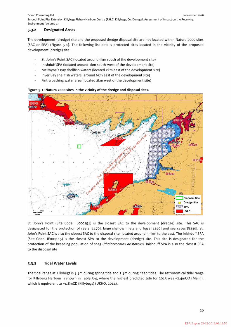
Doran Consulting Ltd November 2016
Smooth Point Pier Extension Killybegs Fishery Harbour Centre (F.H.C) Killybegs, Co. Donegal; Assessment of Impact on the Receiving
Environment (Volume 1)
26
5.3.2 Designated Areas
The development (dredge) site and the proposed dredge disposal site are not located within Natura 2000 sites
(SAC or SPA) (Figure 5-1). The following list details protected sites located in the vicinity of the proposed
development (dredge) site:
- St. John’s Point SAC (located around 5km south of the development site)
- Inishduff SPA (located around 7km south-west of the development site)
- McSwyne’s Bay shellfish waters (located 2km east of the development site)
- Inver Bay shellfish waters (around 6km east of the development site)
- Fintra bathing water area (located 2km west of the development site)
Figure 5-1: Natura 2000 sites in the vicinity of the dredge and disposal sites.
St. John’s Point (Site Code: IE000191) is the closest SAC to the development (dredge) site. This SAC is
designated for the protection of reefs [1170], large shallow inlets and bays [1160] and sea caves [8330]. St.
John’s Point SAC is also the closest SAC to the disposal site, located around 5.5km to the east. The Inishduff SPA
(Site Code: IE004115) is the closest SPA to the development (dredge) site. This site is designated for the
protection of the breeding population of shag (Phalacrocorax aristotelis). Inishduff SPA is also the closest SPA
to the disposal site
5.3.3 Tidal Water Levels
The tidal range at Killybegs is 3.5m during spring tide and 1.5m during neap tides. The astronomical tidal range
for Killybegs Harbour is shown in Table 5-4, where the highest predicted tide for 2015 was +2.4mOD (Malin),
which is equivalent to +4.8mCD (Killybegs) (UKHO, 2014).
For
insp
ectio
n pur
pose
s only
.
Conse
nt of
copy
right
owne
r req
uired
for a
ny ot
her u
se.
EPA Export 03-12-2016:02:12:50

Doran Consulting Ltd November 2016
Smooth Point Pier Extension Killybegs Fishery Harbour Centre (F.H.C) Killybegs, Co. Donegal; Assessment of Impact on the Receiving
Environment (Volume 1)
27
Table 5-4: Tidal range at Killbegs Harbour
Tide Condition Ordnance Datum (Malin) Chart Datum (Killybegs)
Highest Astronomical Tide (HAT) +2.4m +4.8m
Mean High Water Spring (MHWS) +1.7m +4.1m
Mean High Water Neap (MHWN) +0.6m +3.0m
Mean Low Water Neap (MLWN) -0.9m +1.5m
Mean Low Water Spring (MLWS) -1.8m +0.6m
An extreme value analysis for coastal water levels in the vicinity of Killybegs Harbour has been carried out as
part of the Irish Coastal Protection Strategy Study, commissioned by the Office of Public Works. The 1 in 200
year event water level is calculated to be +3.204mOD (Malin), whilst the 1 in 1,000 year event water level is
calculated to be +3.427mOD (Malin). These values translate to +5.604mCD (Killybegs) and +5.827mCD
(Killybegs) respectively1.
5.3.4 Tidal Currents
A number of studies have shown that tidal currents are weak (less than 10 cm/s) within the semi-enclosed bays
of Killybegs Harbour, McSwynes Bay and Inver Bay2,3, associated with weak tidal flushing. Modelling
4 has
shown that tidal circulation within the Killybegs Harbour inlet is rectilinear, dictated by incoming flood and
outgoing ebb tides, with the highest velocities occurring at the narrow inlet mouth to the south of the harbour.
The main non-tidal current in the wider Donegal Bay area has been shown by both measurement and
hydrodynamic modelling to circulate in an anti-clockwise direction3. At the proposed dredge disposal site this
current circulation produces a net north-western current direction3.
5.3.5 Waves
Wave penetration from outside Killybegs Harbour
Previous studies5 of the wave climate within Killbegs Harbour show that relatively short period waves (6 second
mean period) approaching from between 200-220° penetrate furthest into the harbour. Larger swells
approaching from a similar direction are refracted into the coast at the harbour entrance. Significant wave
heights in the area of smooth point under existing conditions are predicted to be in the order of 0.9 – 1.2m
during a 1 in 50 year return period storm from 200 - 220°.
Local wave generation within Killybegs Harbour
Previous studie5s have shown that there will be a variation in locally generated wave climate depending on the
prevailing storm direction, with south easterly storms likely to produce the largest locally generated waves (up
to 0.67m significant wave height).
1 RPS (2013) United Fish Industries (UFI) Fishmeal Plant Reconfiguration Environmental Impact Statement (EIS) 2 Cronin et.al (February 2004). The Salmon Mortalities at Inver Bay and McSwyne’s Bay Finfish farms, County Donegal, Ireland, during 2003 report 3 Department of Communications, Marine And Natural Resources (January 2004). Investigations of Salmon Mortalities at Inver Bay and McSwynes Bay
Fish Farms, Summer 2003 (Kirk McClure Morton, 4 Aquafact (2016) Mathematical modelling for a dredge and a spoil disposal site in Donegal Bay. Part of the development works proposed for Killybegs Harbour ( Refer to Technical Appendix 5.1) 5 Department of Communications, Marine And Natural Resources (2005). Killybegs Marina Wave Climate Analysis, Kirk McClure Morton.
For
insp
ectio
n pur
pose
s only
.
Conse
nt of
copy
right
owne
r req
uired
for a
ny ot
her u
se.
EPA Export 03-12-2016:02:12:50

Doran Consulting Ltd November 2016
Smooth Point Pier Extension Killybegs Fishery Harbour Centre (F.H.C) Killybegs, Co. Donegal; Assessment of Impact on the Receiving
Environment (Volume 1)
28
5.3.6 Morphology
Killybegs Harbour
The dominant habitats within Killybegs Harbour and neighbouring McSwynes Bay consist of shallow sublittoral
muds and sands, with shallow sublittoral rock and reef also present6. Recent sampling has shown the
sediments overlying bedrock within the proposed dredge area consist of a mix of sands and muds with some
gravel also present7.
Smooth Point is the tip of a larger relict depositional feature which is no longer present following the recent
harbour developments. It is now surrounded by dredged navigation channels and backed by a rip-rap wall. The
morphological processes involved in the formation of this feature are therefore absent or have been
significantly modified.
Killybegs harbour is designated as a Heavily Modified Water Body (HMWB) under WFD regulations, due to the
significant alterations to the coastline resulting from the development of harbour infrastructure.
Dredge Disposal Site
The dredge disposal site is located in the outer open waters of Donegal Bay. The dominant habitat at this
location is shelf sublittoral sands7. This site has been used for disposal of dredge sediments during previous
phases of harbour development at Killybegs. Recent sampling at the disposal site (Technical Appendix 6.2) has
shown sediments to consist of very fine sand and silt-clay, indicative of a low energy depositional environment
(low wave energy and weak tidal streams).
5.3.7 Hydrology
The main freshwater inflow to Killybegs Harbour is Bungosteen River also referred to as Stragar River. The river
enters Killybegs Harbour at the northern end of the harbour inlet, north-east of Killybegs itself. An additional
minor inflow of freshwater is delivered from the Cashelcummin River through Killybegs town, this is a minor
watercourse draining a small catchment of around 2km2(8)
.
The cumulative contributing fluvial catchment discharging to the bay is approximately 44km2, producing a
mean freshwater inflow of 1.4m3/s. This combined inflow of freshwater is insignificant in comparison to the
much larger volumes of seawater exchanged within the harbour inlet 9,10
5.3.8 Water Quality and Water Body Status
Killybegs Harbour is classified under the Water Framework Directive (WFD) monitoring programme as a coastal
waterbody. The harbour is classified as being of overall ‘Moderate’ status based upon the final River Basin
Management Plan, 2009 – 2015, due to reduced levels of dissolved oxygen measured within the waterbody.
The harbour is also classified as a heavily modified waterbody.
The Stragar (Bungosteen) River is classified as being of overall ‘Poor’ status based upon the final River Basin
Management Plan, 2009 – 2015, due to poor macroinvertebrate status and a resultant poor ecological status.
The river is not classified as being heavily modified.
6 http://atlas.marine.ie/ 7 Aquafact (2016) Marine Sediment and Benthic Studies for Killybegs Harbour Dredging and Disposal Operations (Refer to Technical Appendix 6.2) 8 North Western – Neagh Bann (NWNB) (2015). Catchment Flood Risk Assessment and Management (CFRAM) Study, HA01 Hydraulics Report Killybegs Model 9 RPS (2013) United Fish Industries (UFI) Fishmeal Plant Reconfiguration Environmental Impact Statement (EIS) 10 Mathematical modelling for a dredge and a spoil disposal site in Donegal Bay. Part of the development works proposed for Killybegs Harbour
For
insp
ectio
n pur
pose
s only
.
Conse
nt of
copy
right
owne
r req
uired
for a
ny ot
her u
se.
EPA Export 03-12-2016:02:12:50
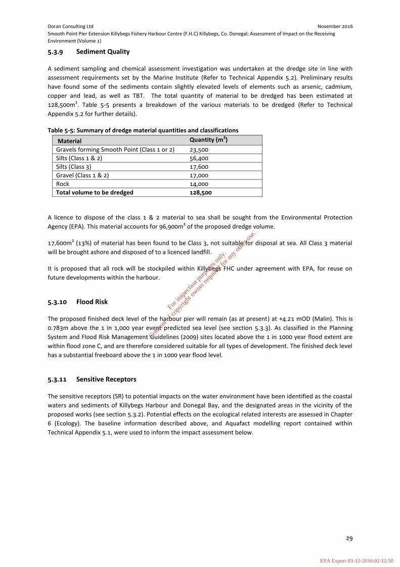
Doran Consulting Ltd November 2016
Smooth Point Pier Extension Killybegs Fishery Harbour Centre (F.H.C) Killybegs, Co. Donegal; Assessment of Impact on the Receiving
Environment (Volume 1)
29
5.3.9 Sediment Quality
A sediment sampling and chemical assessment investigation was undertaken at the dredge site in line with
assessment requirements set by the Marine Institute (Refer to Technical Appendix 5.2). Preliminary results
have found some of the sediments contain slightly elevated levels of elements such as arsenic, cadmium,
copper and lead, as well as TBT. The total quantity of material to be dredged has been estimated at
128,500m3. Table 5-5 presents a breakdown of the various materials to be dredged (Refer to Technical
Appendix 5.2 for further details).
Table 5-5: Summary of dredge material quantities and classifications
Material Quantity (m3)
Gravels forming Smooth Point (Class 1 or 2) 23,500
Silts (Class 1 & 2) 56,400
Silts (Class 3) 17,600
Gravel (Class 1 & 2) 17,000
Rock 14,000
Total volume to be dredged 128,500
A licence to dispose of the class 1 & 2 material to sea shall be sought from the Environmental Protection
Agency (EPA). This material accounts for 96,900m3 of the proposed dredge volume.
17,600m3 (13%) of material has been found to be Class 3, not suitable for disposal at sea. All Class 3 material
will be brought ashore and disposed of to a licenced landfill.
It is proposed that all rock will be stockpiled within Killybegs FHC under agreement with EPA, for reuse on
future developments within the harbour.
5.3.10 Flood Risk
The proposed finished deck level of the harbour pier will remain (as at present) at +4.21 mOD (Malin). This is
0.783m above the 1 in 1,000 year event predicted sea level (see section 5.3.3). As classified in the Planning
System and Flood Risk Management Guidelines (2009) sites located above the 1 in 1000 year flood extent are
within flood zone C, and are therefore considered suitable for all types of development. The finished deck level
has a substantial freeboard above the 1 in 1000 year flood level.
5.3.11 Sensitive Receptors
The sensitive receptors (SR) to potential impacts on the water environment have been identified as the coastal
waters and sediments of Killybegs Harbour and Donegal Bay, and the designated areas in the vicinity of the
proposed works (see section 5.3.2). Potential effects on the ecological related interests are assessed in Chapter
6 (Ecology). The baseline information described above, and Aquafact modelling report contained within
Technical Appendix 5.1, were used to inform the impact assessment below.
For
insp
ectio
n pur
pose
s only
.
Conse
nt of
copy
right
owne
r req
uired
for a
ny ot
her u
se.
EPA Export 03-12-2016:02:12:50

Doran Consulting Ltd November 2016
Smooth Point Pier Extension Killybegs Fishery Harbour Centre (F.H.C) Killybegs, Co. Donegal; Assessment of Impact on the Receiving
Environment (Volume 1)
30
5.4 Impact Assessment
5.4.1 Potential Impacts
This section identifies the potential environmental impacts on the coastal processes, hydrology and water
quality at and around the site during the construction of the proposed works. The site is not considered to be
at risk of flooding, and the proposed works will not alter the existing flood risk, therefore flooding is not
considered further in this assessment.
The proposed works will involve the following key construction and operation activities which have the
potential to impact the water environment within the site and environs:
Dredging of Smooth Point and adjacent sediments;
Drilling and blasting to soften rock;
Construction activities (harbour wall extension and breasting dolphins); and
Disposal of dredged sediments.
The potential environmental impacts on the water environment and around the site during the construction
phase are described in the following sections. These potential impacts include:
Tidal current velocities alterations (changes in flow current velocities and direction and resulting
changes in sedimentation/erosion) caused by removal of Smooth Point shallows and deepening of
navigation channel;
Changes in wave climate caused by removal of Smooth Point shallows and deepening of navigation
channel;
Changes to sediment transport caused by removal of Smooth Point shallows and deepening of
navigation channel;
Contamination of coastal water and sediments through spillages and/or sediment transfer (oil, fuels
and suspended solids);
Contamination of coastal water and sediments through dispersal and disposal of dredged sediments;
and
Interactions between water environment impacts and ecology (assessed within Chapter 6 Ecology).
The following sections consider the potential impacts and provide an assessment of likely level of significance.
5.4.2 Construction Phase Assessment
The potential impacts identified are assessed under the following headings:
Tidal current velocities alterations;
Wave action;
Changes to sediment transport; and
Water and sediment quality.
The degree of potential environmental impact is provided as appropriate.
Tidal current velocities alterations
The removal of the Smooth Point sediments, and associated deepening and widening of the navigation
channel, could result in alterations to the tidal current velocities. The proposed works could decrease average
tidal velocity magnitudes in the vicinity of Smooth Point due to the increased depth and resultant reduction in
For
insp
ectio
n pur
pose
s only
.
Conse
nt of
copy
right
owne
r req
uired
for a
ny ot
her u
se.
EPA Export 03-12-2016:02:12:50

Doran Consulting Ltd November 2016
Smooth Point Pier Extension Killybegs Fishery Harbour Centre (F.H.C) Killybegs, Co. Donegal; Assessment of Impact on the Receiving
Environment (Volume 1)
31
flow constriction. The proposed works could also therefore produce a more uniform velocity profile in the
vicinity of the works.
As described in Technical Appendix 5.1, the Killybegs harbour inlet is subject to slack tidal current velocities.
Given the slack tidal currents within the harbour inlet, and the location of Smooth Point within the centre of
the working harbour, surrounded by dredged berths and navigation channels, it is considered that any
alterations to current velocities will be minor and localised. Therefore no significant impact is predicted and
alterations to current velocities within the dredge zone are not considered further in this assessment.
The proposed dredge disposal works are not considered likely to have an impact on currents at the disposal site
given the depth of the site (circa 70m below mean sea level). Therefore alterations to current velocities within
the disposal site are not considered further in this assessment.
Wave action
The proposed dredging works have the potential to alter the local wave climate. Increased water depth could
produce an increase in wave magnitude within the harbour as a result of a reduction in wave breaking. The
proposed area of dredging could also increase the distance of wave penetration into the harbour. However,
given the location of Smooth Point within the centre of the working harbour, surrounded by dredged berths
and navigation channels, it is considered that any alterations to wave action will be minor and localised.
Therefore no significant impact is predicted and alterations to wave action within the dredge zone are not
considered further in this assessment.
Any localised increase in wave action will have negligible impact on the stability of the foreshore given the
engineered nature of the foreshore in the vicinity of the proposed works.
The proposed dredge disposal works are not considered likely to have an impact on wave action at the disposal
site given the depth of the site. Therefore alterations to wave action within the disposal site are not considered
further in this assessment.
Changes to sediment transport
The proposed dredging has the potential to alter the existing sediment transport regime within the harbour. It
is likely that the new deepened area would act similarly to the existing adjacent dredged areas, as a zone of low
energy and deposition. Hydraulic modelling and field measurements indicate that Killybegs Harbour, and the
surrounding area of Donegal Bay, are subject to weak tidal currents11
. This in combination with the naturally
deep nature of the outer harbour indicates there is only a limited supply of sediment to the dredge site. This is
confirmed by the lack of requirement for maintenance dredging of the harbour navigation channels and berths.
Therefore it is considered that the proposed dredging works will have a negligible impact on sediment
transport processes.
Site investigations and modelling of the disposal site (Appendix X) indicate that this is a low energy depositional
environment, located in deep water. Given the limited potential for sediment transport at the disposal site it is
considered that the proposed dredge disposal activities will not impact on existing sediment transport
processes.
Water and sediment quality
The proposed site activities may lead to physical and chemical contamination of the environment. The level of
significance strongly depends on the potential magnitude of the impact in relation to the scale of the receiving
water.
11 Mathematical modelling for a dredge and a spoil disposal site in Donegal Bay. Part of the development works proposed for Killybegs Harbour
For
insp
ectio
n pur
pose
s only
.
Conse
nt of
copy
right
owne
r req
uired
for a
ny ot
her u
se.
EPA Export 03-12-2016:02:12:50
Doran Consulting Ltd November 2016
Smooth Point Pier Extension Killybegs Fishery Harbour Centre (F.H.C) Killybegs, Co. Donegal; Assessment of Impact on the Receiving
Environment (Volume 1)
32
Suspended solids from dredging works
The proposed dredging works could potentially cause plumes of suspended solids and a reduction in water
quality with a resultant impact on aquatic life. Based on information available to date including sampling, as
reported in Aquafact report Marine Sediment and Benthic Studies for Killybegs Harbour Dredging and Disposal
Operations (Technical Appendix 6.2), the bed sediments predominantly consist of sands. Within the intertidal
dredge area there is a significant proportion of gravel within the bed sediment, whilst in the subtidal area there
is a significant proportion of silt-clay. There is therefore a greater potential for sediment suspension within the
subtidal portion of the dredge requirement.
Sediment transport modelling simulations (refer to Technical Appendix 5.1) indicate that due to the slack
currents present within the harbour inlet, heavier fractions will settle out within the dredge area, and any
suspended sediment plume produced during the dredge works will remain within the harbour inlet. Due to the
rectilinear circulation within the harbour inlet on the flood and ebb tides, mixing across the inlet is likely to be
limited. The most significant transport occurs during spring tides, with the plume modelled to elongate in a
southerly direction along the western shoreline during the ebbing tide, and in a northerly direction during the
flood tide. During a spring flood tide there is greater mixing of the plume across the harbour channel. Under
neap tide conditions the transport of any suspended sediment plume is reduced, remaining locally within the
dredge zone.
The sediment transport modelling used a conservative approach, implementing a conservative 5% spillage rate
during dredging works, considered to be well in exceedance of expected levels. The model results show that
sediment plume concentrations decrease with distance away from the dredge site, and also decrease with
elevation towards the water surface. Across the wider harbour channel typical sediment concentrations in the
bottom layer are 10 to 15mg/l on the spring ebb tide, and approximately 25 mg/l on the spring flood tide.
Modelled concentrations in the surface layer are lower, typically ranging between 5 and 10 mg/l. Within the
dredge area and active harbour modelled concentrations are slightly higher.
The predicted suspended sediment plume has been shown within the Aquafact Mathematical modelling for a
dredge and a spoil disposal site in Donegal Bay. Part of the development works proposed for Killybegs Harbour
report (Technical Appendix 5.1) to be of localised extent, confined to the Killybegs Harbour inlet and
predominantly within the active harbour area. This is also a short term impact, limited to the duration of the
proposed dredging works. Therefore it is considered that the proposed dredging works will have a localised low
to medium and short-term impact on water quality within the Killybegs Harbour inlet as a result of suspended
sediment.
Suspended solids from dredge disposal
The proposed dredge disposal works could potentially cause plumes of suspended solids and a reduction in
water quality with a resultant impact on aquatic life. Based on the Aquafact modelling report ((Technical
Appendix 5.1) the suspended sediment plume during dredge disposal operations will remain well offshore in
deep water during the dumping period. The heavier sand fractions will drop out within the disposal area, whilst
finer silts will be subject to suspension and transport outside the disposal area. The plume is predicted to
disperse around the disposal site, with peak modelled sediment concentrations of approximately 125mg/l
immediately east and west of the disposal site, and mean concentrations of less than 50mg/l. To the north and
south of the disposal site peak concentrations are predicted to be lower (50mg/l) with median concentrations
also lower (20mg/l). The elevated concentrations will only be present in the bottom layer, and will quickly
disperse. Modelled suspended sediment concentrations decrease with distance from the disposal site.
The predicted suspended sediment plume has been shown within the Aquafact modelling report ((Technical
Appendix 5.1) to be restricted to deep offshore waters within the vicinity of the disposal site. Elevated
concentrations are predicted within the bottom layer, and will be localised and of short duration. Therefore it is
For
insp
ectio
n pur
pose
s only
.
Conse
nt of
copy
right
owne
r req
uired
for a
ny ot
her u
se.
EPA Export 03-12-2016:02:12:50

Doran Consulting Ltd November 2016
Smooth Point Pier Extension Killybegs Fishery Harbour Centre (F.H.C) Killybegs, Co. Donegal; Assessment of Impact on the Receiving
Environment (Volume 1)
33
considered that the proposed dredge disposal works will have a localised low and short-term impact on water
quality within the open water vicinity of the proposed disposal site.
Suspended solids from drilling and blasting
There may be a requirement for drilling and blasting to remove bedrock within the dredge area. Should drilling
or blasting be required these activities have the potential to cause localised suspension of sediments. The areas
to be drilled and blasted will have been dredged to remove all other sediment in advance, therefore reducing
the potential to generate significant suspended solids during blasting. The potential impact is therefore
considered to be medium to low, short term and limited to the construction phase.
Oil and fuels contamination
The operation of dredging plant within the harbour area has the potential for releases of oils or fuels during the
works. The potential impacts are dependent on the nature of a release. The potential impacts may therefore
range from low to high.
Sediment quality (dredged material)
The proposed dredging works could potentially lead to chemical contamination of the environment as a result
of suspension and dispersal of poor quality sediment during dredging operations. The sediment sampling and
assessment investigation carried out for the proposed dredge site found 17,600m3 of silt within the dredge
requirement to be Class 3, with chemical levels in exceedance of action level 2, and therefore not suitable for
disposal at sea. The potential impact is therefore considered to be low to high.
5.5 Mitigation Measures
Mitigation aims to avoid, manage, control and further minimise pollution impacts. Two forms of mitigation are
applicable to the potential impacts predicted:
Design led active mitigation, and
Procedural and best practice mitigation.
5.5.1 Design Mitigation
Design led mitigation that has been applied can be summarised as follows:
Water and sediment quality
Identified contaminated sediment found unsuitable for disposal at sea to be removed by excavator
with environmental bucket for processing and disposal on land;
The use of trailer suction dredger or environmental bucket for capital dredge of fine and medium
sediment to limit spillage; and
The direction of the dredging works will be orientated with the current, instead of across the current,
and the programme of works will be planned, monitored and managed to minimise the potential
negative impacts on water quality.
For
insp
ectio
n pur
pose
s only
.
Conse
nt of
copy
right
owne
r req
uired
for a
ny ot
her u
se.
EPA Export 03-12-2016:02:12:50

Doran Consulting Ltd November 2016
Smooth Point Pier Extension Killybegs Fishery Harbour Centre (F.H.C) Killybegs, Co. Donegal; Assessment of Impact on the Receiving
Environment (Volume 1)
34
5.5.2 Construction Phase Mitigation
As described in the impact assessment above, the proposed development is not predicted to have any
significant effects in terms of tidal currents, wave action or sediment transport. Therefore mitigation in relation
to these coastal processes is not required and the following mitigation therefore focuses on water and
sediment quality.
Water and sediment quality
Avoiding water pollution impacts during construction is in reality relatively straightforward albeit it relies on
good management to implement the appropriate mitigation. There are a number of good practice guides which
can be used by Contractors and supervisory personnel. In the absence of Irish equivalent Pollution Prevention
Guidelines (PPGs) it is recommended that Scottish Environment Protection Agency (SEPA) guidance are utilised,
including:
PPG 1: General guide to the prevention of pollution;
PPG 2: Above ground oil storage tanks;
PPG3: Use and design of oil separators in surface water drainage systems;
PPG5: Works and maintenance in/near water;
PPG 6: Working at construction and demolition sites;
PPG 7: Safe Storage – The safe operation of refuelling facilities;
PPG 8: Safe storage and disposal of used oils;
PPG 18: Managing fire water and major spillages;
PPG 21: Pollution incident response planning;
PPG26: Safe Storage – Drums and Intermediate bulk containers;
WAT-SG-26: Good Practice Guide – Sediment Management;
WAT-SG-29: Good Practice Guide – Construction Methods; and
Guidelines for Water Pollution Prevention from Civil Engineering Contracts.
The following specific mitigation will be adopted:
An Accident Management Plan will also be prepared for the construction phase, taking full
consideration of best practice, statutory requirements and identification of areas of highest sensitivity.
This will provide site spill response procedures, emergency contact details and equipment inventories
and their location. All operation staff will be made aware of this document, and its content, during site
induction and it will be available in the site office (PPG1, PPG7, PPG18, and PPG21);
Appropriate spill kits or absorbent material will be stored adjacent to site during works (PPG1);
Any refuelling facilities will be inspected regularly and the maintenance record will be available for
inspection (PPG7);
Staff/contractor will be trained in the use of spill kits and other pollution control equipment and the
operation of pollution control devices (PPG22);
Use of suitably internally bunded fuel bowsers (i.e. bund to contain volume of bowser plus 10%);
Waste rock from the dredge removal will be stored, handled, reused/recycled where possible and
disposed according to legal requirement (PPG1, PPG6);
Visual inspections of harbour to be carried out during works;
The Dredging & Disposal Operation Monitoring Plan (Technical Appendix 5.3) will be implemented
prior to, during and after construction (further details are provided in section 5.5.3 below); and
It is recommended that the construction works be carried out under the guide of a Construction
Environmental Management Plan (CEMP).
For
insp
ectio
n pur
pose
s only
.
Conse
nt of
copy
right
owne
r req
uired
for a
ny ot
her u
se.
EPA Export 03-12-2016:02:12:50

Doran Consulting Ltd November 2016
Smooth Point Pier Extension Killybegs Fishery Harbour Centre (F.H.C) Killybegs, Co. Donegal; Assessment of Impact on the Receiving
Environment (Volume 1)
35
5.5.3 Monitoring
A monitoring plan for the proposed dredging and disposal operations has been prepared by Aquafact
International, and is presented in Technical Appendix 5.3. The proposed monitoring programme covers a pre-
dredge baseline phase, the active dredge and disposal operations, and a post-works monitoring phase.
Monitoring buoys will be deployed at 5 targeted locations, covering the Killybegs harbour area, the dredge
disposal site, McSwynes Bay and St. John’s Point. An additional mobile monitoring campaign is proposed during
the dredging operation, along with sampling of plankton, sediment and fauna.
5.6 Residual Impacts
A summary of the impact analysis and residual impacts following mitigation is provided within Table 5-6 below.
Predicted potential impacts range from high to negligible. Following the application of the proposed mitigation
described above, residual impacts range from low to negligible.
For
insp
ectio
n pur
pose
s only
.
Conse
nt of
copy
right
owne
r req
uired
for a
ny ot
her u
se.
EPA Export 03-12-2016:02:12:50

Doran Consulting Ltd November 2016
Smooth Point Pier Extension Killybegs Fishery Harbour Centre (F.H.C) Killybegs, Co. Donegal; Assessment of Impact on the Receiving Environment (Volume 1)
36
Table 5-6: Summary of residual impacts
Effect Source of Impact Type of Effect Duration Probability of
occurrence
Magnitude of
impact Pre-
mitigation
Significance of
impact pre-
mitigation
Mitigation measure Residual impact
(post mitigation)
Tidal current alterations Dredging works Negative Permanent Likely Negligible Negligible None proposed Negligible
Changes in wave
climate Dredging works Negative Permanent Likely Negligible Negligible None proposed Negligible
Changes to sediment
transport Dredging works Negative Permanent Likely Negligible Negligible None proposed Negligible
Contamination of
coastal water and
sediments through
spillages and/or
sediment transfer
Suspended
sediments -
Dredging works
Negative Short term Possible Low Low
Use of suction dredger and/or
environmental bucket.
Direction and programme of
dredging works.
Low
Oils and fuels Negative Short term Possible Low to High Low to Medium
Accident Management Plan for
spills and other releases.
Storage of appropriate spills
kits.
Staff/contractor training on
usage of spill kits and pollution
control equipment.
Low
Suspended
sediments -
Drilling and
blasting
Negative Short term Possible Medium to Low Low
Adherence to general best
practice and construction
method statement by
Contractor.
Appropriate timing of works.
Low
Contamination of
coastal water and
sediments through
dispersal and
disposal of dredged
sediments
Suspended
sediments –
Dredge disposal
Negative Short term Possible Low Low Monitoring of works and
appropriate licencing. Low
For
insp
ectio
n pur
pose
s only
.
Conse
nt of
copy
right
owne
r req
uired
for a
ny ot
her u
se.
EPA Export 03-12-2016:02:12:50
Doran Consulting Ltd November 2016
Smooth Point Pier Extension Killybegs Fishery Harbour Centre (F.H.C) Killybegs, Co. Donegal; Assessment of Impact on the Receiving
Environment (Volume 1)
37
6 ECOLOGY
6.1 Context
This assessment considers the potential effects of the development on the ecological interests in and around
the quay construction area, the dredging area and disposal ground. It contains a description of the baseline
conditions, the predicted effects and proposes mitigation measures where appropriate.
In assessing the potential impacts on the ecology of the harbour, consideration has been given to level of
current activity taking place, as the harbour is one with a high volume of vessel movements and associated
harbour activities.
Terrestrial and coastal margin surveys and assessments were carried out by EnviroCentre, with marine
assessments carried out by Aquafact. The various inputs are referenced in the assessment below for clarity.
6.2 Assessment Methodology
In general, the assessments considered previous information from reports available, desktop published
information, and where necessary the desktop information available was supplemented by field surveys and
sampling. Given the diversity of the types of surveys carried out the survey methodologies varied as described
in the reports referenced in this chapter.
Following collation of desktop and survey data, potential impacts were considered and described along with
appropriate mitigation where required. Residual impacts are also acknowledged.
Surveys carried out by EnviroCentre included Otter surveys and a Phase 1 Habitat Survey. The full report for
these surveys is contained in Technical Appendix 6.1. Summary of the methods employed is provided below.
Otter
An otter survey was undertaken on Friday 10th
June 2016 in good conditions, (air temperature 180C , 76-100%
cloud cover and dry). The antecedent conditions were similar.
The survey was undertaken by experienced and competent ecologists, who are members of the Chartered
Institute of Ecology and Environmental Management (CIEEM). The survey followed best practice guidelines
(Chanin, 2003), and searched for suitable habitat along with field signs, including:
Spraints (otter faeces/droppings used as territorial signposts. Often located in prominent positions and can be placed on deliberate piles of soil or sand). Three categories are used for describing otter spraint: Dried fragmented (Df); Dried intact (Di); Not fully dry (Nd);
Footprints;
Feeding remains (can often be a useful indication of otter presence);
Paths/slides (otter can often leave a distinctive path from and into the watercourse);
Holts (underground shelter) are generally found: o Within trees roots at the edge of the bank of a river; o Within hollowed out trees;
o In naturally formed holes in the river banks that can be easily extended;
o Or preferably in ready-made holes created by other large mammals or humans such as badger setts, rabbit burrows or outlet pipes; and
For
insp
ectio
n pur
pose
s only
.
Conse
nt of
copy
right
owne
r req
uired
for a
ny ot
her u
se.
EPA Export 03-12-2016:02:12:50

Doran Consulting Ltd November 2016
Smooth Point Pier Extension Killybegs Fishery Harbour Centre (F.H.C) Killybegs, Co. Donegal; Assessment of Impact on the Receiving
Environment (Volume 1)
38
o Couches/lay-ups (couches or lay-ups are places for lying up above ground are usually located
near a watercourse, between rocks or boulders, under dense vegetation).
The site and buffer was walked prior to low tide. At low tide the immediate vicinity of the site was searched
and the foreshore was accessed where practicable to search for any spraint sites or footprints. This was
followed by a survey of the harbour area by boat. Due to the site being within a working harbour binoculars
were used to view the rock armour and harbour wall from a boat where access was limited due to safety
constraints.
Terrestrial Phase 1 Habitat Survey
A Phase 1 Habitat Survey was also undertaken. Phase 1 Habitat survey is a method that rapidly records
vegetation and habitat over large areas. The output of this survey comprises a habitat map, associated target
notes and photographs. The information is used to identify ecologically sensitive features, inform additional
species surveys and, ultimately, recommend broad mitigation and optional enhancement measures in relation
to the proposed development. The Phase 1 Habitat Survey was undertaken according to the standard Joint
Nature Conservation Committee method (JNCC, 2010).
For the marine environment Aquafact carried out several different surveys and assessments. The scope and
method for each of these is described below.
Marine Sediment and Benthic Studies for Killybegs Harbour Dredging and Disposal Operations
A subtidal benthic assessment of the dredge and disposal areas was undertaken by, Aquafact who sampled a
total of 12 stations. Sampling took place on the 15th
March and 15th
August 2016 from Sinbad Marine’s SMS
Cian (The full report is provided within Technical Appendix 6.2).
Aquafact has in-house standard operational procedures for benthic sampling and these were followed for this
project. Additionally, the recently published MESH report on “Recommended Standard methods and
procedures” was adhered to.
A Sediment Profile Imagery (SPI) survey was also carried out to characterise the baseline seafloor conditions at
the disposal site and the reference stations prior to the planned disposal operations taking place. The survey
was envisaged as the first phase of a Before After Control Impact (BACI) study. The main aim of this BACI study
is to detect variability in environmental conditions and to differentiate between anthropogenic driven change
and natural variability in the ecosystem following the disposal of dredge spoil. To that effect appropriate
controls were chosen as reference for ambient conditions for the area (see Underwood, 1991 and references
therein).
A Sediment Profile Imaging (SPI) camera apparatus was used in Donegal Bay to examine the nature of the
seafloor and its associated faunal communities. SPI facilitates the assessment of the biophysical processes that
occur in the benthic environment through the acquisition of high resolution images of vertical sections and
plane views of the seafloor.
Impact Risk Assessment for Large Megafauna in Donegal Bay
The potential for noise impacts and collision risk impacts on a variety of marine megafauna was carried out by
Aquafact using desk based information for the various species. The full report including methods and other
referenced studies is provided in Technical Appendix 6.3.
Fisheries
A desk based assessment was also carried out which considered the general setting of the area, existing
fisheries (shellfish and finfish), and migratory fish.
For
insp
ectio
n pur
pose
s only
.
Conse
nt of
copy
right
owne
r req
uired
for a
ny ot
her u
se.
EPA Export 03-12-2016:02:12:50

Doran Consulting Ltd November 2016
Smooth Point Pier Extension Killybegs Fishery Harbour Centre (F.H.C) Killybegs, Co. Donegal; Assessment of Impact on the Receiving
Environment (Volume 1)
39
6.2.1 Other Sources of Information
To inform the AIRE many sources of information were used which included:
National Parks & Wildlife Service (NPWS) - www.npws.ie;
National Biodiversity Data Centre online mapping – www.biodiversityireland.ie;
Botanical Society of the British Isles - www.bsbi.org.uk;
Invasive Species Ireland - www.invasivespeciesireland.com;
Geological Survey Ireland (GSI) Area Maps (http://www.gsi.ie/mapping.htm);
Water Framework Directive Ireland (http://www.wfdireland.ie/maps.html);
Chartered Institute of Ecology & Environmental Management (CIEEM) - www.cieem.net;
Killybegs Harbour Development, Environmental Impact Statement (EIS) (2001); and
United Fish Industries (UFI) Fishmeal Plant Reconfiguration Environmental Impact Statement
(EIS) (2013).
6.2.2 Assessment Criteria
As each individual technical report has individually assessed the impact on the specific subject area, those
assessments have been used within this document. For full criteria of the various assessment methods within
this Ecology Chapter, please refer to the following individual technical reports (provided as Technical
Appendices):
Technical Appendix 5.1 - Mathematical modelling for a dredge and a spoil disposal site in Donegal Bay. Part of the development works proposed for Killybegs Harbour;
Technical Appendix 6.1 - Killybegs Harbour Development Phase 1 Habitat & Otter Survey;
Technical Appendix 6.2 - Marine Sediment and Benthic Studies for Killybegs Harbour Dredging and Disposal Operations; and
Technical Appendix 6.3 - Killybegs Harbour expansion project, Impact risk assessment for large megafauna in Donegal Bay.
Where relevant, a basic negligible - low – medium – high scale has been used as a summary assessment for this document.
6.2.3 Legislation, Policy and Guidance
There is a significant amount of legislation to be considered in relation to ecology. The most important
legislation underpinning biodiversity and nature conservation in Ireland includes:
The Wildlife Act, 1976 as amended by the Wildlife Act 1976 (Protection of Wild Animals) Regulations,
1980, the Wildlife (Amendment) Act 2000 and the Wildlife (Amendment) Act 2010 (The Wildlife Act);
European Communities (Conservation of Wild Birds) Regulations 1985 (as amended by S.I. 31/1995);
European Communities (Natural Habitats) Regulations, S.I. 94/1997 as amended by S.I. 233/1998 & S.I.
378/2005 (The Habitats Regulations);
European Communities (Birds and Natural Habitats) Regulations 2011 (S.I. 477/2011);
Guidance on the implementation of the EU nature legislation in estuaries and coastal zones with
particular attention to port development and dredging (EC 2012);
The Flora (Protection) Order, 1999 (S.I. No. 94/1999);
The Planning & Development Acts, 2000-2010;
National Biodiversity Plan, 2002;
Biodiversity Species List for County Donegal (with priorities)(2009); and
For
insp
ectio
n pur
pose
s only
.
Conse
nt of
copy
right
owne
r req
uired
for a
ny ot
her u
se.
EPA Export 03-12-2016:02:12:50
Doran Consulting Ltd November 2016
Smooth Point Pier Extension Killybegs Fishery Harbour Centre (F.H.C) Killybegs, Co. Donegal; Assessment of Impact on the Receiving
Environment (Volume 1)
40
Threat Response Plan: Otter 2009-2011 (DEHLG, 2009).
6.3 Baseline Conditions
The baseline ecological status of the development and the dredge and disposal areas and wider Donegal Bay
are described below.
6.3.1 Designated Sites
Killybegs Harbour is not located within any designated sites, however, there are a range of conservation
designations within 15km of the site, including designations through the Natura 2000 network.
A Natura Impact Statement (NIS) screening report and NIS Informative report has been prepared for the
proposed Killybegs Harbour pier extension (Refer to Technical Appendix 6.4 and 6.5). An assessment of
potential effects on Natura 2000 sites is therefore not repeated here within this chapter.
6.3.2 Otter
There are historical records of otter in the vicinity of Killybegs Harbour. The Killybegs Harbour Development
(2001) EIS states that the upper reaches of Killybegs harbour support several families of otter. A survey was
undertaken at that time to locate otter holts in the vicinity of the works. Two otter shelters were identified
within the proposed development area. Neither otter shelter had a breeding function and both appeared to be
in only occasional use. No otter holts or field signs of otter were found on Smooth Point, in the immediate
vicinity of Smooth Point or within the 250m buffer north and south of the site along the harbour wall. During
the development of the harbour in 2001 a wildlife corridor was established that links the coastline from the
where the harbour rock armour starts to more suitable habitat to the west of the harbour development. This
corridor was not surveyed within the scope of this work but would provide refuge for otter in the area.
The otter survey undertaken on Friday 10th
June 2016 found no otter holts or field signs on Smooth Point, in
the immediate vicinity of Smooth Point or within the 250m buffer north and south of the site along the harbour
wall (Refer to Technical Appendix 6.1).
6.3.3 Benthic Environment - Results
Benthic communities were sampled to provide an indication of baseline conditions. In total, 12 stations were
sampled. 5 stations plus 3 control sites were sampled at the disposal site and 3 stations plus 1 control site was
sampled at the dredge site. Details of sample locations and sample processing are provided within the Aquafact
report in Technical Appendix 6.2. The results are summarised below from the same referenced report.
Dredge Site - Fauna
The taxonomic identification of the benthic infauna across all 4 stations sampled at the dredge site yielded a
total count of 76 taxa ascribed to 10 phyla. Of the 76 taxa, 1 could not be enumerated due to its colonial nature
(sponge) and the remaining 75 taxa consisted of 1,252 individuals. Of the 76 taxa recorded, 46 were identified
to species level. The remaining 30 could not be identified to species level as they were either juveniles, partial,
damaged or indeterminate.
Of the 76 taxa present, 1 was a poriferan (sponge), 1 was a cnidarian (corals, anemones, jellyfish etc.), 1 was a
platyhelminth (flatworm), 1 was a nematode (roundworm), 2 were a nemerteans (ribbon worms), 38 were
annelids (segmented worms including sipunculids), 10 were crustaceans (crabs, shrimps, prawns), 21 were
For
insp
ectio
n pur
pose
s only
.
Conse
nt of
copy
right
owne
r req
uired
for a
ny ot
her u
se.
EPA Export 03-12-2016:02:12:50
Doran Consulting Ltd November 2016
Smooth Point Pier Extension Killybegs Fishery Harbour Centre (F.H.C) Killybegs, Co. Donegal; Assessment of Impact on the Receiving
Environment (Volume 1)
41
molluscs (mussels, cockles, snails etc.), 1 was an echinoderm (brittlestars, starfish, sea cucumbers) and 1 was a
tunicate (sea squirt). Technical Appendix 6.2 provides full analysis.
Dredge Site - Sediment
The sediment sampled from the area was classified according to Folk (1954) as a mix of sandy gravel, slightly
gravelly muddy sand, muddy sand and the control site was classified as gravelly muddy sand.
Water
Suspended solids concentrations were 11.3 mg/l at surface and 11.9 mg/l at depth. The suspended solid levels
correspond to a turbidity value of 5 FTU (Formazin Turbidity Unit).
Disposal Site - Fauna
The taxonomic identification of the benthic infauna across all 8 stations sampled at the disposal site yielded a
total count of 209 taxa ascribed to 10 phyla. The 209 taxa consisted of 2,449 individuals. Of the 209 taxa
identified, 148 were identified to species level. The remaining 61 could not be identified to species level as they
were either juveniles, partial, damaged or indeterminate.
Of the 209 taxa present, 4 were cnidarians (corals, anemones, jellyfish etc.), 1 was a nematode (roundworm), 5
were nemerteans (ribbon worms), 89 were annelids (segmented worms including sipunculids), 1 was a
chelicerate (sea spider), 44 were crustaceans (crabs, shrimps, prawns), 47 were molluscs (mussels, cockles,
snails etc.), 1 was a phoronid (horseshoe worm), 16 were echinoderms (brittlestars, starfish, sea cucumbers)
and 1 was a hemichordate (acorn worm).
Disposal Site - Sediment
The sediment sampled from the area was classified according to Folk (1954) as muddy sand with one exception
of sand at a single station sampled.
Water
Suspended solids concentrations were 7.93 mg/l at surface and 14.2 mg/l at depth. The suspended solid levels
correspond to a turbidity value of 1.4 and 4.2 respectively.
6.3.4 Benthic Communities and Discussion
Dredge Site - Killybegs Harbour
The sheltered nature of the area and the weak current speeds and poor flushing characteristics give rise to a
depositional site where fine materials and organics settle to the seafloor. The sediment type within the dredge
site varied from a sandy gravel close to smooth point in waters <5m deep to muddy sand and slightly gravelly
muddy sand in waters >5m deep. The muddy sand stations had high silt-clay fractions and associated with
these were high organic carbon levels.
The faunal assemblage recorded from these stations is similar to the JNCC SS.SMU.SMuVS.Cap.Tubi Capitella
capitata and Tubificoides spp. in reduced salinity infralittoral muddy sediment biotope (EUNIS A5.325). The
presence of dense Capitella has classically been associated with organically enriched and physically disturbed
habitats in the marine environment (Warren, 1977; Pearson & Rosenberg, 1978). Capitella and or Tubificoides
were the main components of the other stations sampled in the area along with a number of other polychates.
These assemblages did not resemble any predefined JNCC biotopes. In general, the assemblages observed in
the dredge are species poor and not very diverse.
For
insp
ectio
n pur
pose
s only
.
Conse
nt of
copy
right
owne
r req
uired
for a
ny ot
her u
se.
EPA Export 03-12-2016:02:12:50

Doran Consulting Ltd November 2016
Smooth Point Pier Extension Killybegs Fishery Harbour Centre (F.H.C) Killybegs, Co. Donegal; Assessment of Impact on the Receiving
Environment (Volume 1)
42
Disposal Site
Regarding the disposal site, the high percentage of very fine sand and silt-clay in the area is indicative of low
wave energy/weak tidal streams that allow fine sediments to settle out the sea bed. The measurements made
by the current meter at the site support this hypothesis as only low velocities i.e. + 10 cms.sec were recorded.
Organic material has a high affinity for fine material and the levels encountered are typical of muddy sand
habitats. These stable communities tend to support a rich infaunal community. The species that are
characteristic of the disposal site are typical of stable muddy sand habitats and they are dominated by deposit
feeding polychaetes feeding on the organics present in the sediment.
All sites within the disposal site and the 2 control sites could not be statistically differentiated from each other
based on the faunal assemblage. All sites were characterised by the same polychaete species: Galathowenia
oculata, Owenia borealis, Chaetozone setosa, Prionospio sp., Prionospio fallax and Cirratulidae. This assemblage
was classified as slightly disturbed according to AMBI. This is due to the fact that there is a fairly even split
between the abundance of species that are sensitive or indifferent to disturbance and those who can tolerate
or thrive in disturbed sediments.
A characteristic feature of the molluscan fauna collected was the fact that many specimens were juveniles. This
feature was also a finding of the initial base line survey carried out by the Aquatic Services Unit of University
College Cork in 2001 (ASU, 2001) and a post-disposal survey carried by Wood Environmental Management Ltd
in August 2002 (WEML, 2002).
These latter two surveys record the faunal assemblage as a Clausinella fasciata-type grouping. However, the
faunal assemblage recorded from the site does not fit into one of the predefined EUNIS or JNCC biotopes. This
is not to say that the assemblage is rare or unusual. All species recorded are common and typical of this type of
sedimentary environment. It may however, be attributable to a variety of Thorson’s (1957) Amphiura
assemblage. Natural spatial variations and seasonal variations between assemblages and amongst the
dominating species within assemblages result is heterogeneous communities that cannot all be captured in
predefined classification models.
6.3.5 Megafauna
The Irish Whale and Dolphin Group (IWDG) operates an all-Ireland database of casual cetacean sightings. Since
2001, regular monthly effort-related surveys from land-based stations have been included in the IWDG
database. All records are validated and available on the National Biodiversity Mapping System
(http://maps.biodiversityireland.ie).
The Aquafact Report “Killybegs Harbour expansion project: Impact risk assessment for large megafauna in
Donegal bay” (Refer to Technical Appendix 6.3) identifies the locations of recent sightings such as baleen whale
(Mysticeti) records validated by the IWDG in the Donegal Bay area. In total, only two species have been
recorded within Donegal Bay i.e. minke whale and fin whale (dead stranded animals only).
As regards to toothed whales (Odontoceti), a total of ten species has been recorded within Donegal Bay, the
three most abundant being bottlenose dolphin, common dolphin and harbour porpoise, in that order. Other
species include orca, Risso’s dolphin, white-beaked dolphin, striped dolphin, white-sided dolphin, Cuvier’s
beaked whale and sperm whale. Of those, only orca and Risso’s dolphin were live animals, the rest being
reported as stranded (dead) specimens.
Common seals and grey seals are common in the Donegal Bay area, particularly in the inner section where a
haul-out and a breeding site exists.
Although Donegal Bay historically supported a basking shark fishery, there are no recent records of live basking
shark in the area.
For
insp
ectio
n pur
pose
s only
.
Conse
nt of
copy
right
owne
r req
uired
for a
ny ot
her u
se.
EPA Export 03-12-2016:02:12:50

Doran Consulting Ltd November 2016
Smooth Point Pier Extension Killybegs Fishery Harbour Centre (F.H.C) Killybegs, Co. Donegal; Assessment of Impact on the Receiving
Environment (Volume 1)
43
Leatherback turtle is recorded annually in Irish waters, and six have been recorded within Donegal Bay, four of
which were stranded animals.
6.3.6 Fisheries
Shellfish Farms
Killybegs Harbour is situated c. 5 kilometres northwest of the McSwynes Bay, designated Shellfish Waters
under the EC (Quality of Shellfish Waters) Regulations 2006 (SI 268 of 2006) (as amended in 2009) (Figure 6-1).
McSwynes Bay is situated on the southwest coast of County Donegal in the North Western International River
Basin District. The bay is exposed to the southwest but is protected to the east by the long arm of St. Johns
Point and to the west by Carntullagh Head. The substrate varies from clean sand to rock. Inter-tidal areas are
very limited and only at Bruckless Harbour does much of the sea bed become exposed at low water. A number
of shallow rocky reefs are located in the north of the bay, a single tiny island known as the Green Island is also
located in the north of the bay12
.
Figure 6-1: McSwynes Bay
The designated shellfish area within the bay is 2.7 km2 in area. It covers all of McSwynes Bay within a line
south-east from Multins and west from Kiln Port. The dedicated shellfish samples available for this shellfish
area are compliant with shellfish mandatory and guideline values outlined in Annex I of the Shellfish Waters
12
Shellfish Pollution Reduction Programme: Characterisation Report Number 21 McSwynes Bay Shellfish Area County Donegal
For
insp
ectio
n pur
pose
s only
.
Conse
nt of
copy
right
owne
r req
uired
for a
ny ot
her u
se.
EPA Export 03-12-2016:02:12:50
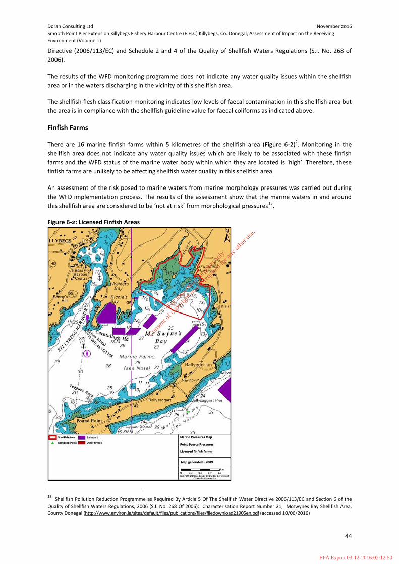
Doran Consulting Ltd November 2016
Smooth Point Pier Extension Killybegs Fishery Harbour Centre (F.H.C) Killybegs, Co. Donegal; Assessment of Impact on the Receiving
Environment (Volume 1)
44
Directive (2006/113/EC) and Schedule 2 and 4 of the Quality of Shellfish Waters Regulations (S.I. No. 268 of
2006).
The results of the WFD monitoring programme does not indicate any water quality issues within the shellfish
area or in the waters discharging in the vicinity of this shellfish area.
The shellfish flesh classification monitoring indicates low levels of faecal contamination in this shellfish area but
the area is in compliance with the shellfish guideline value for faecal coliforms as indicated above.
Finfish Farms
There are 16 marine finfish farms within 5 kilometres of the shellfish area (Figure 6-2)2. Monitoring in the
shellfish area does not indicate any water quality issues which are likely to be associated with these finfish
farms and the WFD status of the marine water body within which they are located is ‘high’. Therefore, these
finfish farms are unlikely to be affecting shellfish water quality in this shellfish area.
An assessment of the risk posed to marine waters from marine morphology pressures was carried out during
the WFD implementation process. The results of the assessment show that the marine waters in and around
this shellfish area are considered to be ‘not at risk’ from morphological pressures13
.
Figure 6-2: Licensed Finfish Areas
13
Shellfish Pollution Reduction Programme as Required By Article 5 Of The Shellfish Water Directive 2006/113/EC and Section 6 of the
Quality of Shellfish Waters Regulations, 2006 (S.I. No. 268 Of 2006): Characterisation Report Number 21, Mcswynes Bay Shellfish Area,
County Donegal (http://www.environ.ie/sites/default/files/publications/files/filedownload21905en.pdf (accessed 10/06/2016)
For
insp
ectio
n pur
pose
s only
.
Conse
nt of
copy
right
owne
r req
uired
for a
ny ot
her u
se.
EPA Export 03-12-2016:02:12:50

Doran Consulting Ltd November 2016
Smooth Point Pier Extension Killybegs Fishery Harbour Centre (F.H.C) Killybegs, Co. Donegal; Assessment of Impact on the Receiving
Environment (Volume 1)
45
Migratory Fish
There is a migratory run of salmon and sea trout through Killybegs Harbour to and from the Bungosteen
(Stragar) River.
The Bungosteen River rises in the Crockanpeast Mountains, northwest of Killybegs and flows into Donegal Bay
at the most northerly point of Killybegs Harbour. The catchment of the Bungosteen River is greatly extended by
a number of tributaries. The largest of which are the Stragar, Loughaderry, Roechrow, and Meengilcarry Rivers.
Loughaderry Reservoir, which provides the water supply for Killybegs Town, is the only major lake on this river
system.
The Standing Scientific Committee on Salmon produced an independent scientific report to Inland Fisheries
Ireland (The Status of Irish Salmon Stocks in 2014 with Precautionary Catch Advice for 2015) stated Irish Salmon
Stocks in the Bungosteen River fell below Conservation Limits.
The Conservation Limit (CL) is the number of spawning salmon required to produce the next generation of
salmon. A group of expert fisheries scientists (the Scientific Standing Committee) develop the CL using the
wetted area of each river along with its latitude to determine the number of salmon eggs required to populate
this area. An assessment is made annually as to whether the conservation limit is reached by using the average
fish counter data, salmon rod catches, redd counts, or by catchment wide electro fishing from the previous five
years of data. The conservation limit for a river is the number of spawning salmon required to produce the next
generation of salmon. The conservation limit is fixed for each river based on the wetted area latitude and other
river specific factors i.e. the proportion of one sea winter salmon and multi sea winter salmon in the population
the average weight of these salmon proportions of male and female salmon and average numbers of eggs per
female fish.
Atlantic salmon and sea trout may be present in the area with different life stages and species likely to be
present at different times of year and possibly at different states of the tide, etc. Some of the in-migrating adult
fish may wait in the development area for suitable conditions to ascend. Smolts moving downstream may also
pass through the area. Adult salmon migrate upstream between August and September/October and prefer
shallow water, 1m-3m deep. Smolts migrate downstream in May and June with the main flow, i.e. in the
deeper channels. Seasonal timings of the return of trout from the sea depend on their place of origin.
6.4 Impact Assessment
This assessment has focused on the potential for direct or indirect impact impacts in relation to the following:
Otter;
Benthic Environments (Dredge Site and Disposal Site Fauna and Sediment, and Water);
Benthic Communities (Dredge Site (Killybegs Harbour) and Disposal Site);
Megafauna; and
Fisheries (Shellfish and Finfish Farms and Migratory Fish).
6.4.1 Existing Impacts
Killybegs is an operational harbour, and an insignificant level of ecological impact already occurs. E.g. the sea
bed is disturbed from dredging and propeller wash from boats entering and leaving the harbour. In addition,
there is generation of underwater noise, and the terrestrial area is artificially illuminated at unnatural times.
For
insp
ectio
n pur
pose
s only
.
Conse
nt of
copy
right
owne
r req
uired
for a
ny ot
her u
se.
EPA Export 03-12-2016:02:12:50

Doran Consulting Ltd November 2016
Smooth Point Pier Extension Killybegs Fishery Harbour Centre (F.H.C) Killybegs, Co. Donegal; Assessment of Impact on the Receiving
Environment (Volume 1)
46
6.4.2 Identified Potential Impacts
The sources of additional impacts on ecological receptors arising from the construction of a pier extension are
considered to be:
Direct habitat loss or habitat disturbance and faunal disturbance or displacement from construction
activity and increased levels of activity once the pier extension is operational;
Impacts from increased dredging activity and sediment disposal; and
Higher levels of collision risk for cetaceans and pinnipeds and increased underwater noise from vessel
movement and construction activity.
Increased illumination of the Killybegs Harbour area, and increased likelihood of oil spillage due to a higher
level of activity once the new pier is operational, are not considered to constitute additional risks to ecological
receptors, as current operational mitigation measures are in place to minimise any impact these actions may
cause. Therefore, they are not considered further within this assessment.
6.4.3 Otter
Suitable resting places were recorded, and there is anecdotal evidence of their presence around the harbour.
However, no signs of otter have been recorded recently, and although construction of the pier extension may
result in disturbance to otter habitat, or to any animals present in the area, any impact is assessed as negligible.
6.4.4 Benthic Environments
Dredge Site
The Aquafact technical report, “Mathematical modelling for a dredge and a spoil disposal site in Donegal Bay.
Part of the development works proposed for Killybegs Harbour” (Technical Appendix 5.1) concludes the impact
of the capital dredge works on sediment deposition is local to the commercial port area and represents a minor
impact to the wider Killybegs Harbours area and negligible impact outside of Killybegs Harbour.
Disposal Site
The Aquafact technical report, “Mathematical modelling for a dredge and a spoil disposal site in Donegal Bay.
Part of the development works proposed for Killybegs Harbour” (Technical Appendix 5.1) concludes that
sediment depositional depths that could give rise to benthic impact at coastal sites would generally be above
2cm. The sediment transport simulations show that such depths and above are generally confined to the
disposal site and the immediate area surrounding it and therefore a wider impact outside the disposal site is
not predicted.
Water
The Aquafact technical report, “Mathematical modelling for a dredge and a spoil disposal site in Donegal Bay.
Part of the development works proposed for Killybegs Harbour” (Technical Appendix 5.1) concludes that the
modelling clearly shows that the sediment plume impact is confined to the receiving waters of Killybegs
Harbour and does not extend out into the adjoining bays of Fintragh, Richie’s and McSwyne’s Bays, or the
approaches to Killybegs Harbour. Therefore the operational impact of the proposed dredging works will be
confined to this bay and will not have implications further afield.
For
insp
ectio
n pur
pose
s only
.
Conse
nt of
copy
right
owne
r req
uired
for a
ny ot
her u
se.
EPA Export 03-12-2016:02:12:50

Doran Consulting Ltd November 2016
Smooth Point Pier Extension Killybegs Fishery Harbour Centre (F.H.C) Killybegs, Co. Donegal; Assessment of Impact on the Receiving
Environment (Volume 1)
47
6.4.5 Benthic Communities
Dredge Site (Killybegs Harbour)
The Aquafact technical report, “Mathematical modelling for a dredge and a spoil disposal site in Donegal Bay.
Part of the development works proposed for Killybegs Harbour” (Technical Appendix 5.1) concludes the impact
of the capital dredge works on sediment deposition is local to the commercial port area and represents a minor
impact to the wider Killybegs Harbours area and negligible impact outside of Killybegs Harbour.
Disposal Site
The Aquafact report, “Marine Sediment and Benthic Studies for Killybegs Harbour Dredging and Disposal
Operations” (Technical Appendix 6.2) states that the impact of the disposal of hypoxic sediments dredged in
Killybegs Harbour and disposed of at sea will be to smother the existing sea floor biology at the disposal site. As
current velocities have been shown to be low, the lateral drift of the sediment plume will restrict its
distribution outside the disposal site and the smothering impact will be restricted to within the area of the
disposal site. Benthic infauna react to smothering by actively burrowing up through the sediment to regain
access to the sea floor/water column interface. The report concludes that sedimentary habitats that dominate
the existing disposal site and adjacent areas can be regarded as similar to ambient conditions for this area of
Donegal Bay. Although it is clear that previous disposal operations have impacted the sedimentary structure of
the site (chiefly sediment compactness), sediment granulometry consisting of fine sands and relatively deep
redox layers are similar to those recorded from ambient conditions. The relatively quick recolonisation of the
site by an array of bioturbating taxa has contributed to the recovery of the site. This bioturbating activity
continues to be relatively intense, both at the existing disposal site and the general surrounding area.
The Aquafact report, “Site selection process for the disposal of dredge spoil from Killybegs Harbour to a location
in Donegal Bay”14
concludes that at previous disposal sites in Donegal Bay of dredged material, the benthos
recovered relatively quickly with negative impacts being limited to the centre of the disposal site, the
surrounding areas remaining largely unaffected.
6.4.6 Megafauna
Potential impacts on the megafauna of Donegal Bay are likely to be from an increase in underwater noise levels
generated during construction of the pier extension, and by dredging and disposal operations, and an increase
in collision risk with vessels.
The Aquafact report, “Killybegs Harbour expansion project, Impact risk assessment for large megafauna in
Donegal Bay” (Technical Appendix 6.3) concludes that the likelihood of noise impact on marine mammals is
unlikely, while consequence of any potential negative impact is negligible (direct injury) or moderate
(behavioural disturbance on foraging seals or dolphins caused by the dredging). Considering the infrequent and
temporary nature of the dredging and transport operations the overall the risk is regarded as low.
Regarding collision risk for cetaceans and pinnipeds within Donegal Bay, the report continues - considering the
nature and intensity of the existing traffic in the area and that transit and operational speeds of the vessel
involved in the transport of dredge spoil to and from the site it is unlikely that collision with marine mammals,
basking sharks and turtles will be of significance. The consequences of a potential impact at the predicted
vessel speeds are regarded to range from minor (whales and dolphins) to medium (basking shark, turtles) while
the likelihood of occurrence is regarded to range from possible (basking sharks, turtles) to remote (whales and
dolphins). Considering that the impact will be temporary and intermittent during the duration of the transport
14 Aquafact report “Site selection process for the disposal of dredge spoil from Killybegs Harbour to a location in Donegal Bay” (September 2016)
For
insp
ectio
n pur
pose
s only
.
Conse
nt of
copy
right
owne
r req
uired
for a
ny ot
her u
se.
EPA Export 03-12-2016:02:12:50

Doran Consulting Ltd November 2016
Smooth Point Pier Extension Killybegs Fishery Harbour Centre (F.H.C) Killybegs, Co. Donegal; Assessment of Impact on the Receiving
Environment (Volume 1)
48
operations, the overall impact is thus regarded as low (whales, dolphins) or medium for basking sharks and
turtles.
Regarding seal collisions with vessel propellers, Aquafact states that it is unlikely, but there is still a medium risk
of such incidents occurring especially if the vessels are fitted with ducted propellers.
6.4.7 Fisheries
Shellfish Farms
The Aquafact technical report, “Mathematical modelling for a dredge and a spoil disposal site in Donegal Bay.
Part of the development works proposed for Killybegs Harbour” (Technical Appendix 5.1) concludes that higher
concentrations of sediment are expected from the increased dredging and subsequent disposal of the material.
The modelling shows no significant deposition outside of Killybegs Harbour itself (i.e. < 1mm) and this includes
no depositional impact on the adjoining bays of Fintragh to the west and McSwyne’s to the east. Therefore
sediment concentrations do not appear to be affected in areas of shellfish farming.
Finfish Farms
The Aquafact technical report, “Mathematical modelling for a dredge and a spoil disposal site in Donegal Bay.
Part of the development works proposed for Killybegs Harbour” (Technical Appendix 5.1) concludes that higher
concentrations of sediment are expected from the increased dredging and subsequent disposal of the material.
In areas where the nearest finfish farms operate in Richie’s Bay, the highest predicted concentrations of 5 mg/l
are unlikely to cause problems for fish farms, particularly as the highest concentrations are confined to the
bottom layer. The modelling shows no significant deposition outside of Killybegs Harbour itself (i.e. < 1mm) and
this includes no depositional impact on the adjoining bays of Fintragh to the west and McSwyne’s to the east.
Migratory Fish
The Aquafact technical report, “Mathematical modelling for a dredge and a spoil disposal site in Donegal Bay.
Part of the development works proposed for Killybegs Harbour” (Technical Appendix 5.1) concludes that in
terms of fish passage into and out of Killybegs Harbour the overall impact on the harbour channel width is the
critical factor. Typically on spring tides the sediment concentration in the bottom layer is 10 to 15 mg/l and it
the surface layer it is 5 to 10 mg/l and on the flooding tide this increases only in the lower layer to
approximately 25 mg/l. On neap tides the impact across the width is below 5 mg/l both in the bottom and top
layers. These predicted concentrations are unlikely to cause problems for fish passage and particularly as the
highest concentrations are confined to the bottom layer.
6.5 Mitigation Measures
Mitigation seeks to:
Avoid negative ecological impacts – especially those that could be significant;
Reduce negative impacts that cannot be avoided; and
Compensate for any remaining significant ecological impacts.
Much of the relevant/necessary mitigation is already built into the design and will also be covered by following
standard best practice guidance (e.g. pollution prevention measures) during the construction period. This
For
insp
ectio
n pur
pose
s only
.
Conse
nt of
copy
right
owne
r req
uired
for a
ny ot
her u
se.
EPA Export 03-12-2016:02:12:50

Doran Consulting Ltd November 2016
Smooth Point Pier Extension Killybegs Fishery Harbour Centre (F.H.C) Killybegs, Co. Donegal; Assessment of Impact on the Receiving
Environment (Volume 1)
49
section therefore focuses on additional mitigation that will be required for the specific ecological receptors
assessed in this chapter.
Mitigation is possible for the following negative impacts during construction:
Underwater noise (drilling and blasting).
The success of this mitigation is assessed as certain. The methods provided below have been applied on other
projects within the harbour and have shown to be successful.
No mitigation is possible for negative impacts during operation.
6.5.1 Mitigation
Underwater Noise
1. A ‘soft start’ method will be employed, whereby a Marine Mammal Observer (MMO) surveys the
potential impact zone, covering a minimum radius of 750m and beyond (where practicable), for
cetaceans and pinnipeds prior to drilling and blasting operations. The impact zone being measured
from the outermost boreholes on any given blast sequence.
The MMO will observe the impact zone for 30minutes prior to the start of works, if no marine
mammals are seen works can commence. If a cetacean or pinniped enters the zone during works the
activity will cease until the animal has moved away. Whereby the process will recommence. MMO
logs should be kept by the contractor as part of the Environmental Management Plan (EMP) for the
contract.
2. In applying the MMO procedure all drilling activity would cease until marine mammals move away
from blast area. If marine mammals move into the area, then health and safety will take precedent,
particularly where vessels need to access or egress the harbour. In this instance, ‘pingers’ would be
deployed to encourage the mammals to move out of the area.
Pingers would be used as a ‘last resort’ as these cause deliberate disturbance to cetaceans and
pinnipeds. As such the use of pingers may need to be assessed as part of a European Protected
Species (EPS) licence application.
6.6 Residual Impacts
As little or no mitigation is possible these would remain the same.
6.7 Natura Impact Statement
See the EnviroCentre Reports enclosed as Technical Appendices 6.4 (Natura Impact Statement (Screening)) and
6.5 (Natura Impact Statement (Informative)).
For
insp
ectio
n pur
pose
s only
.
Conse
nt of
copy
right
owne
r req
uired
for a
ny ot
her u
se.
EPA Export 03-12-2016:02:12:50

Doran Consulting Ltd November 2016
Smooth Point Pier Extension Killybegs Fishery Harbour Centre (F.H.C) Killybegs, Co. Donegal; Assessment of Impact on the Receiving
Environment (Volume 1)
50
7 NOISE
7.1 Context
This chapter presents the assessment of potential noise impacts associated with the proposed pier extension at
Killybegs Harbour during the construction phase. The potential impact of noise on ecology is covered in Section
6 Ecology of this AIRE.
There is potential for the noise environment of residents located in close proximity to Killybegs Harbour to be
impacted by construction activities. The activities associated with the actual operation of the harbour are not
anticipated to be significantly noisy once construction works are complete. As stated in Section 3.2,
consultation with the Local Authority has determined that although there will be an increase in traffic during
the construction and operation of the development it is unlikely to affect noise levels within the area. As such
traffic noise has been scoped out of the assessment. The Noise Impact Assessment will therefore focus on the
noise generated by construction of the development only.
7.2 Assessment Methodology
7.2.1 Assessment Methodology
The noise impact assessment was undertaken to assess the potential for construction activities to impact
surrounding sensitive receptors located in the vicinity of the harbour. The assessment involved the following
stages:-
Identification of relevant issues and potential impacts from the Project on the local noise
environment;
Design and completion of day, evening and night time noise monitoring adjacent to the closest noise
sensitive receptors to the proposed development area;
Review of noise source data for the proposed plants to be working onsite during the construction
phase of the proposed development;
Review of other relevant data regarding noise sources for the site e.g. dredging;
Assessment of change in noise levels at the noise sensitive receptors by comparing the predicted
construction noise levels with the background noise levels; and
Proposal of mitigation measures (if required) and assessment of cumulative impacts.
7.2.2 Legislation and Guidance
The noise impact assessment has been undertaken in accordance with the following legislation and guidance
documents.
Legislation
EU Directive 2002/49/EC deals with the assessment and management of environmental noise. The directive is
implemented in Ireland by the Environmental Noise Regulations 2006 (SI 140/2006).
For
insp
ectio
n pur
pose
s only
.
Conse
nt of
copy
right
owne
r req
uired
for a
ny ot
her u
se.
EPA Export 03-12-2016:02:12:50

Doran Consulting Ltd November 2016
Smooth Point Pier Extension Killybegs Fishery Harbour Centre (F.H.C) Killybegs, Co. Donegal; Assessment of Impact on the Receiving
Environment (Volume 1)
51
British Standards
BS 7445-1:2003 “Description and Measurement of Environmental Noise. Guide to Quantities and
Procedures” (BSI, 2003); and
BS 5228-1:2009 “Code of practice for noise and vibration control on construction and open sites.
Noise” (BSI, 2009).
“Guidelines for Community Noise” (World Health Organisation, 1999); and
“Night Noise Guidelines for Europe” (World Health Organisation, 2009).
7.2.3 Consultation Outcomes
The Environment Impact Statement Scoping Report was submitted to Donegal County Council on 13 May 2016.
No formal response was received at the time of writing.
Note: The assessment methodology has altered since the scoping report was submitted as a result of the noise
monitoring exercise which indicated that there would minimal noise impacts as a result of construction noise.
7.2.4 Noise Assessment Criteria
BS 5228 (2009), ‘Noise and Vibration Control on Construction and Open Sites’’ provides a “best practice” guide
for noise control and includes sound power level (SPL) data for individual plant as well as a calculation method
for noise from construction activities.
Part 1 of BS5228:2009 provides practical information on noise reduction measures, and promotes “best
practice means” approach to control noise. BS 5228-1:2009 provides example guidance on assessing the
significance of construction noise impacts on sensitive receptors.
The ambient noise level for an appropriate period i.e. day, night, or evening/weekends, is determined and
rounded to the nearest 5dB. This identifies the threshold value to use to assess significance by comparison
with the total predicted construction noise level at the sensitive receptor. If the threshold value is exceeded
then a significant effect is predicted, the level of significance being related to the level of exceedance. The
threshold value criteria are detailed below in Table 7.1 which is taken from BS 5228-1: 209.
Table 7-1: Threshold of significant effect at dwellings.
Assessment category and threshold value period Threshold value, in decibels (dB)
Category A(A) Category B(
B) Category C(
C)
Night-time (23.00-07.00) 45 50 55
Evenings and weekends(D) 55 60 65
Daytime (07.00-19.00) and Saturdays (07.00-13.00) 65 70 75
Notes 1 A significant effect has been deemed to occur if the total LAeq noise level, including construction, exceeds
the threshold level for the Category appropriate to the ambient noise level. 2 If the ambient noise level exceeds the threshold values given in the table (i.e. the ambient noise level is
higher than the above values), then a significant effect is deemed to occur if the total LAeq noise level for the period increases by more than 3 dB due to construction activity.
3 Applied to residential receptors only.
For
insp
ectio
n pur
pose
s only
.
Conse
nt of
copy
right
owne
r req
uired
for a
ny ot
her u
se.
EPA Export 03-12-2016:02:12:50
Doran Consulting Ltd November 2016
Smooth Point Pier Extension Killybegs Fishery Harbour Centre (F.H.C) Killybegs, Co. Donegal; Assessment of Impact on the Receiving
Environment (Volume 1)
52
A: threshold values to use when ambient noise levels (when rounded to the nearest 5 dB) are less than these
values. B: threshold values to use when ambient noise levels (when rounded to the nearest 5dB) are the same as
Category A values. C: threshold values to use when ambient noise levels (when rounded to the nearest 5dB) are higher than
Category A values. D: 19.00-23.00 weekdays, 13.00-23.00 Saturdays and 07.00-23.00 Sundays
The noise impact at the local houses is then obtained by adding the predicted noise levels associated with the
construction activities to the monitored noise levels (LAeq) for each of the residential dwellings included in this
noise assessment. The combined noise levels are then assessed as detailed in Table 7.1.
7.3 Baseline Conditions
7.3.1 Sensitive Receptors
The proposed development is located in an operational harbour with the closest residential property located
on St Catherines Road circa 300 metres distance from the harbour development. In addition, Sensitive
Receptors considered to have a view of the harbour development site are as follows:
Residential properties located around Fintra Road;
Killybegs Community Hospital; and
Binroe Hamlet (located across the water from the harbour).
7.3.2 Baseline Noise Levels
A noise survey was carried out at Killybegs during June 2016. The purpose of the survey was to establish
baseline noise conditions at each of the potentially sensitive noise receptors.
Noise Monitoring Locations
Four noise monitoring locations were used to obtain representative baseline noise levels as listed below and
shown in Figure 7-1 (also refer to Drawing No 267172-003 Noise Monitoring Locations, in Volume 2. Drawings
and Figures).
1 Residential properties located around Fintra Road;
2 Killybegs Community Hospital;
3 Binroe Hamlet (North); and
4 Binroe Hamlet (South).
The residential property located on St Catherine’s Road (Location 5) was not used as a monitoring location as it is mainly affected by existing traffic on the road, while existing harbour buildings such as Mooneys Boats, are located directly between the property and the harbour development area, thus acting as a screen. Therefore background noise level monitoring to assess the impact of on-site construction activities was not carried out at this location.
Given the location of the proposed development works within Killybegs Harbour it was concluded that the sensitive receptor most likely to be impacted was in the vicinity of Killybegs Community Hospital. It was determined that the hospital directly faces the proposed development, has a number of residential properties within a short distance and the Tara Hotel is located approximately 140m to the west, as such would be the most appropriate monitoring location.
For
insp
ectio
n pur
pose
s only
.
Conse
nt of
copy
right
owne
r req
uired
for a
ny ot
her u
se.
EPA Export 03-12-2016:02:12:50

Doran Consulting Ltd November 2016
Smooth Point Pier Extension Killybegs Fishery Harbour Centre (F.H.C) Killybegs, Co. Donegal; Assessment of Impact on the Receiving
Environment (Volume 1)
53
Figure 7-1: Noise Monitoring Locations
Investigation Equipment and Technical Details
A fully calibrated Type 1 sound level meter was used to undertake the noise monitoring during weekday day
evening and night time periods and weekend day time periods as detailed in Table 7-2 below. All
measurements were carried out in good weather conditions (e.g. wind speed was low, weather was dry and
road conditions were free from surface water and / or ice). The sound level meter was calibrated both before
and after measurements were taken and no significant drift was noted.
Table 7-2: Investigative Equipment Utilised & Technical Details
Monitoring Period: Weekday day – 60 Minutes per location Weekday evening – 20 Minutes per location Weekday Night - 20 Minutes per location Weekend Day – 60 Minutes per location
Instrument: Norsonic 140 sound analyser
Calibration: At the start and finish of each monitoring event calibration was completed using a Norsonic NOR-1251 Sound Calibrator
Measurement Settings:
Environmental logging mode: A-weighted sound pressure level with time weighting F
Measurement Positions:
Measurements taken at least 3.5m from reflective surfaces and between 1.2m and 1.5m above the ground.
Baseline Noise Levels
A summary of the noise monitoring results can be found below (Table 7-3).
For
insp
ectio
n pur
pose
s only
.
Conse
nt of
copy
right
owne
r req
uired
for a
ny ot
her u
se.
EPA Export 03-12-2016:02:12:50

Doran Consulting Ltd November 2016
Smooth Point Pier Extension Killybegs Fishery Harbour Centre (F.H.C) Killybegs, Co. Donegal; Assessment of Impact on the Receiving
Environment (Volume 1)
54
Table 7-3: Noise Levels
Date Period Monitoring Location
Time Noise Levels
LAeq LA90 LA10
9&10/06/2016 Night time
1 20 mins 58.1 39.9 55.2
2 20 mins 59.7 37.4 58.9
3 20 mins 37.1 34.7 38.8
4 20 mins 35.2 32.5 37.6
10/06/2016 Week day
1 60 mins 60.6 45.2 65.2
2 60 mins 67.6 50.1 71.9
3 60 mins 40.5 32.6 41.1
4 60 mins 46.8 33.0 39.6
10/06/2016 Week day Evening
1 20 Mins 61.4 46.4 64.9
2 20 Mins 68.9 46.6 73.2
3 20 mins 44.1 36.7 47.5
4 20 mins 44.7 36.8 44.0
11/06/2016 Weekend day
1 60 mins 58.8 41.3 63.9
2 60 mins 65.3 48.2 69.8
3 60 mins 46.0 38.7 43.3
4 Strong wind and rain – unable to do last location
Noise Monitoring Observations
During the monitoring period, notes of significant noise sources affecting each of the monitoring locations were
recorded and are provided in Technical Appendix 7.1.
Observed day time noise sources included:
Operational noise from harbour, i.e. fork lift trucks reversing, “bangs”;
Traffic and pedestrians;
Birds;
Church bells (noon); and
Generator within harbour
Observed night time noise sources included:
Occasional traffic (both distant and close); and
Operational noise from harbour, i.e. generators etc.
7.4 Impact Assessment
This section discusses the potential impacts to existing sensitive receptors associated with noise arising from
the proposed pier extension at Killybegs during construction.
7.4.1 Potential Impacts
In general the noise impacts associated with construction activities are considered to be temporary with the
noise environment returning to background noise levels once construction is completed. In the case of the
construction of the pier extension at Killybegs, it has been assumed this will take place between January 2017
and December 2017.
For
insp
ectio
n pur
pose
s only
.
Conse
nt of
copy
right
owne
r req
uired
for a
ny ot
her u
se.
EPA Export 03-12-2016:02:12:50

Doran Consulting Ltd November 2016
Smooth Point Pier Extension Killybegs Fishery Harbour Centre (F.H.C) Killybegs, Co. Donegal; Assessment of Impact on the Receiving
Environment (Volume 1)
55
The construction activities (as noted in Chapter 2 of the AIRE) have been analysed within this section, in order
to assess the potential for noise associated with construction works to impact the noise environment at
sensitive receptors.
Construction of the harbour extension can be divided into 4 distinct phases as follows:-
Removing existing rock armour and stockpiling within harbour boundary;
Formation of quay wall through piling using driving and rock coring techniques;
Formation of quay slab;
Dredging; and
Generator to power facilities associated with security during the night time period.
In relation to dredging, at this stage of the development site investigations indicate that mechanical plant
should be sufficient to dredge bed rock to the required depth and that no blasting is required. The noise
assessment therefore focuses on the potential for noise from mechanical plant to impact surrounding
receptors. If it is determined that blasting is required to achieve the required depth, the potential for noise to
impact receptors will be assessed and measures put in place to minimise any impacts from this activity.
Activities associated with quay slab formation are not considered to be as noisy as the other phases of the
development. In addition the activities associated with quay slab formation can be controlled through best
practise techniques. The activities associated with this phase of the construction have therefore been
discounted from the assessment.
A detailed construction methodology and associated plant specifications were unknown at the time of the
noise impact assessment being undertaken. In order to predict potential impacts at residential properties,
typical plant were identified based on previous experience of this type of development. The plant that could
be used for each of the construction activities are listed in Table 7-4. The table also provides associated sound
levels obtained from either BS5228 or from EnviroCentre’s noise database.
Table 7-4: Construction Noise Sources
Construction Phase
Construction Activity Plant
Individual Noise Unit
(dBA) at 10m
Quantity
Total Noise
Unit (dBA) at 10m
Removing existing rock armour and stockpiling
Excavation 25t long reach excavator 77 1
80
Dumper Truck tipping / emptying
23t dumper truck 74 1
Wheeled Backhoe Loader
8 t loader 68 1
Dozer 11 t dozer 78 1
Quay Wall Piling
Installing steel sheets Vibratory piling rig 88 1 91
Tubular Steel Piling Hydraulic hammer 4t hammer
87 1
Dredging Dredging / loading onto barges
Backhoe Dredger 105* 1 74
Security Power Supply Diesel Generator 61 1 61
*sound power level at source
During each construction phase it is assumed that plant can operate simultaneously to provide a worst-case
scenario. On review of the combined noise for each phase of the development it is noted that the phase with
the highest predicted noise level is that associated with piling works to form the quay way.
For
insp
ectio
n pur
pose
s only
.
Conse
nt of
copy
right
owne
r req
uired
for a
ny ot
her u
se.
EPA Export 03-12-2016:02:12:50

Doran Consulting Ltd November 2016
Smooth Point Pier Extension Killybegs Fishery Harbour Centre (F.H.C) Killybegs, Co. Donegal; Assessment of Impact on the Receiving
Environment (Volume 1)
56
7.4.2 Sensitive Receptors
Sensitive receptors have been identified in relation to each of the above areas as detailed in Table 7-5 and
shown in Drawing No 267172-003 Noise Monitoring Locations, (Volume 2. Drawings and Figures). To provide a
conservative scenario, the distances from the each of the residents / monitoring locations to the closest part of
each construction area have been measured.
Table 7-5: Construction Noise Sensitive Receptors
SR ID Location Construction Area / Activity ~ Distance (m)
SR1 Residents on Fintra Road
Dredging 690
Rock Armour removal/storage/ re-placement 700
Pier Extension – piling 700
Night time security 650
SR2 Killybegs Community Hospital
Dredging 720
Rock Armour removal/storage/ re-placement 700
Pier Extension – piling 785
Night time security 840
SR3 Binroe Residents (North)
Dredging 650
Rock Armour removal/storage/ re-placement 700
Pier Extension – piling 775
Night time security 830
SR4 Binroe Residents (South)
Dredging 630
Rock Armour removal/storage/ re-placement 700
Pier Extension – piling 770
Night time security 820
SR5 St Catherine’s Road Resident
Dredging 322
Rock Armour removal/storage/ re-placement 322
Pier Extension – piling 311
Night time security 300
Although the Binroe residents (north and south, SR3 and SR4) have a clear view of the harbour construction
site, the closest resident to the harbour is SR5 located on St Catherine’s Road.
7.4.3 Predicted Construction Noise Levels at Sensitive Receptor
In order to provide a conservative scenario the closest receptor i.e. SR5 to the construction site has been taken
forward for assessment purposes. The construction noise assessment requires ambient noise levels to be
defined. As there was no noise monitoring undertaken at SR5 we have assumed that noise levels at this
location can range between the lowest levels recorded across the bay at SR3 and SR4 and the higher levels
recorded at SR1 and SR2. The lowest baseline LAeq’s detailed in Table 7-3 have therefore been considered in
the assessment, again to provide a robust assessment.
The predicted construction noise levels at SR5 were added to the appropriate ambient LAeq noise levels to
calculate the noise levels that will be experienced at the receptor during construction. A summary of the
predicted construction noise levels at SR5 is provided in Table 7-6 with detailed calculations provided in
Technical Appendix 7.1.
For
insp
ectio
n pur
pose
s only
.
Conse
nt of
copy
right
owne
r req
uired
for a
ny ot
her u
se.
EPA Export 03-12-2016:02:12:50

Doran Consulting Ltd November 2016
Smooth Point Pier Extension Killybegs Fishery Harbour Centre (F.H.C) Killybegs, Co. Donegal; Assessment of Impact on the Receiving
Environment (Volume 1)
57
Assumptions
The calculations to predict the construction noise levels at sensitive receptors are based on the following
assumptions.
The percentage on time for all activities have been adjusted to account for worker breaks during the
assessment period;
Distance corrections for all construction activities have been calculated using 100% “hard” ground
calculations to provide a conservative scenario;
The calculations assume the sensitive receptors have a clear line of sight of the activity therefore no
screening correction has been applied;
A -3dB correction has been applied to take into account the influence of reflective surfaces and
thereby provide a conservative scenario
It has been assumed that a plywood construction screen will be in place around the construction area
therefore SR5 will not have a direct line of site of work within this area. A -5dB correction factor has
therefore been applied to the rock armour removal and piling phases of construction. No correction
factor has been applied to the dredging operations and a -10dB correction factor is applied to power
generation during the night time period.
For
insp
ectio
n pur
pose
s only
.
Conse
nt of
copy
right
owne
r req
uired
for a
ny ot
her u
se.
EPA Export 03-12-2016:02:12:50
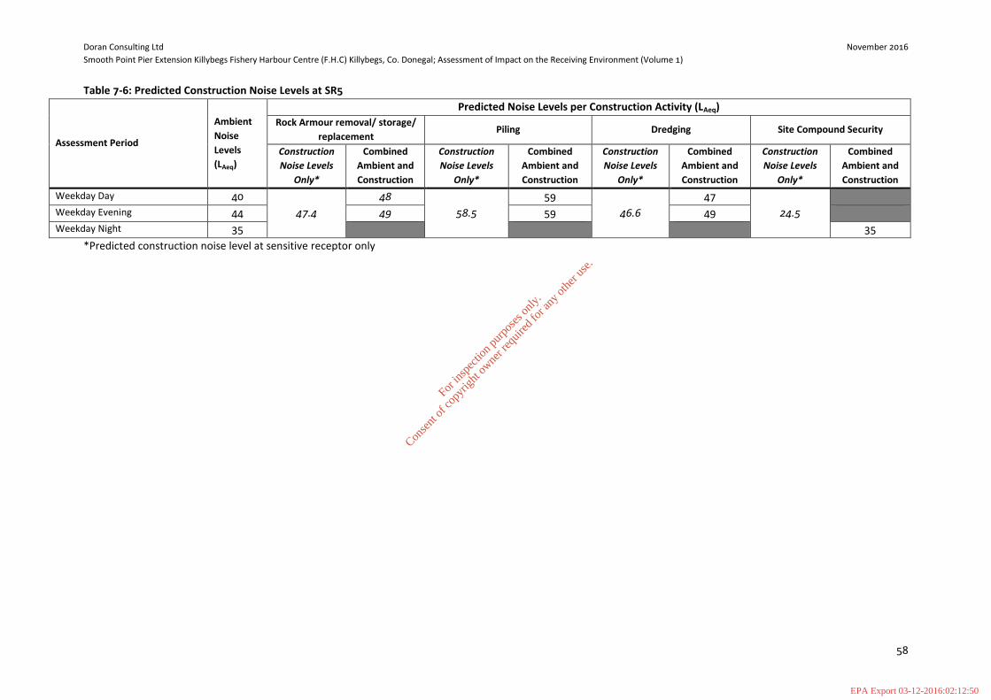
Doran Consulting Ltd November 2016
Smooth Point Pier Extension Killybegs Fishery Harbour Centre (F.H.C) Killybegs, Co. Donegal; Assessment of Impact on the Receiving Environment (Volume 1)
58
Table 7-6: Predicted Construction Noise Levels at SR5
Assessment Period
Ambient
Noise
Levels
(LAeq)
Predicted Noise Levels per Construction Activity (LAeq)
Rock Armour removal/ storage/
replacement Piling Dredging Site Compound Security
Construction
Noise Levels
Only*
Combined
Ambient and
Construction
Construction
Noise Levels
Only*
Combined
Ambient and
Construction
Construction
Noise Levels
Only*
Combined
Ambient and
Construction
Construction
Noise Levels
Only*
Combined
Ambient and
Construction
Weekday Day 40
47.4
48
58.5
59
46.6
47
24.5
Weekday Evening 44 49 59 49
Weekday Night 35 35
*Predicted construction noise level at sensitive receptor only
For
insp
ectio
n pur
pose
s only
.
Conse
nt of
copy
right
owne
r req
uired
for a
ny ot
her u
se.
EPA Export 03-12-2016:02:12:50
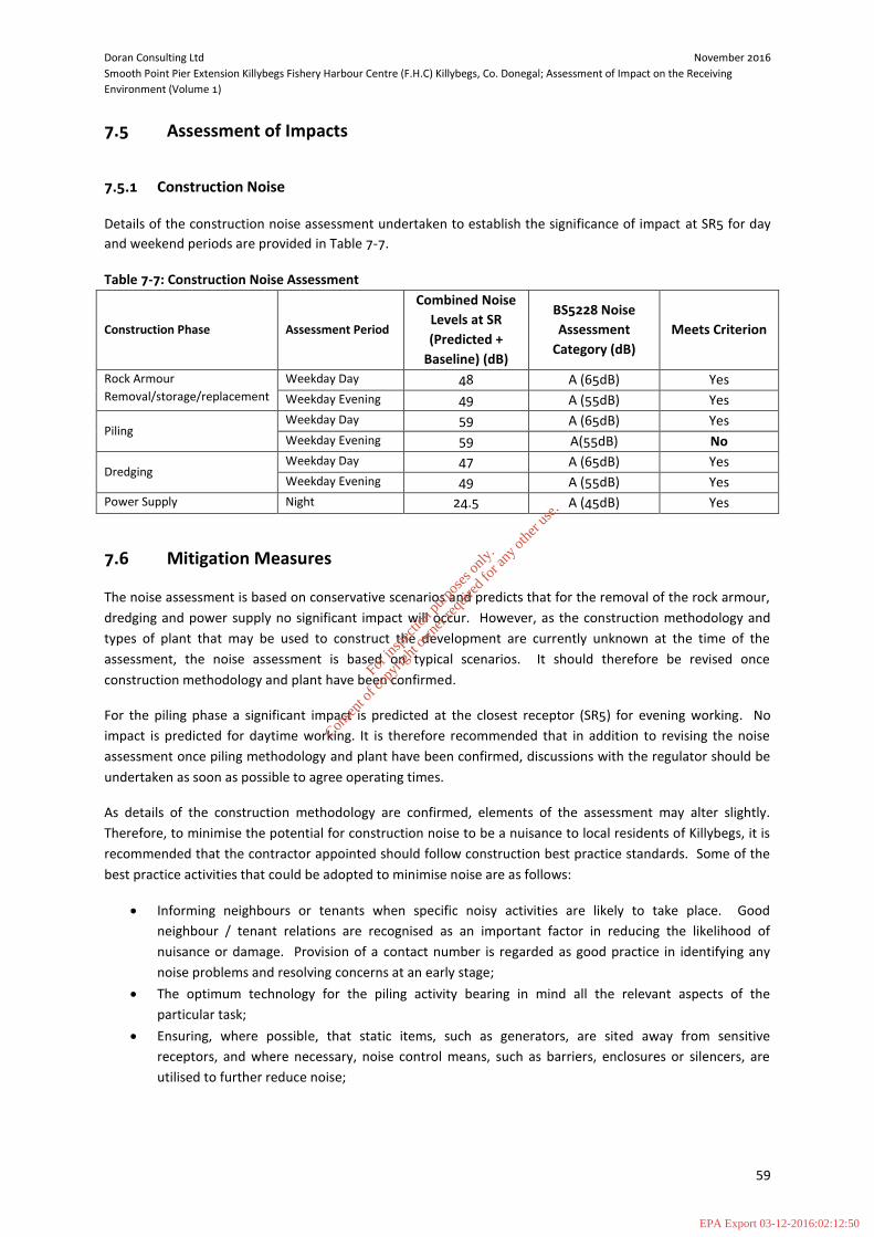
Doran Consulting Ltd November 2016
Smooth Point Pier Extension Killybegs Fishery Harbour Centre (F.H.C) Killybegs, Co. Donegal; Assessment of Impact on the Receiving
Environment (Volume 1)
59
7.5 Assessment of Impacts
7.5.1 Construction Noise
Details of the construction noise assessment undertaken to establish the significance of impact at SR5 for day
and weekend periods are provided in Table 7-7.
Table 7-7: Construction Noise Assessment
Construction Phase Assessment Period
Combined Noise
Levels at SR
(Predicted +
Baseline) (dB)
BS5228 Noise
Assessment
Category (dB)
Meets Criterion
Rock Armour
Removal/storage/replacement
Weekday Day 48 A (65dB) Yes
Weekday Evening 49 A (55dB) Yes
Piling Weekday Day 59 A (65dB) Yes
Weekday Evening 59 A(55dB) No
Dredging Weekday Day 47 A (65dB) Yes
Weekday Evening 49 A (55dB) Yes
Power Supply Night 24.5 A (45dB) Yes
7.6 Mitigation Measures
The noise assessment is based on conservative scenarios and predicts that for the removal of the rock armour,
dredging and power supply no significant impact will occur. However, as the construction methodology and
types of plant that may be used to construct the development are currently unknown at the time of the
assessment, the noise assessment is based on typical scenarios. It should therefore be revised once
construction methodology and plant have been confirmed.
For the piling phase a significant impact is predicted at the closest receptor (SR5) for evening working. No
impact is predicted for daytime working. It is therefore recommended that in addition to revising the noise
assessment once piling methodology and plant have been confirmed, discussions with the regulator should be
undertaken as soon as possible to agree operating times.
As details of the construction methodology are confirmed, elements of the assessment may alter slightly.
Therefore, to minimise the potential for construction noise to be a nuisance to local residents of Killybegs, it is
recommended that the contractor appointed should follow construction best practice standards. Some of the
best practice activities that could be adopted to minimise noise are as follows:
Informing neighbours or tenants when specific noisy activities are likely to take place. Good
neighbour / tenant relations are recognised as an important factor in reducing the likelihood of
nuisance or damage. Provision of a contact number is regarded as good practice in identifying any
noise problems and resolving concerns at an early stage;
The optimum technology for the piling activity bearing in mind all the relevant aspects of the
particular task;
Ensuring, where possible, that static items, such as generators, are sited away from sensitive
receptors, and where necessary, noise control means, such as barriers, enclosures or silencers, are
utilised to further reduce noise;
For
insp
ectio
n pur
pose
s only
.
Conse
nt of
copy
right
owne
r req
uired
for a
ny ot
her u
se.
EPA Export 03-12-2016:02:12:50

Doran Consulting Ltd November 2016
Smooth Point Pier Extension Killybegs Fishery Harbour Centre (F.H.C) Killybegs, Co. Donegal; Assessment of Impact on the Receiving
Environment (Volume 1)
60
Ensuring that, as far as reasonably practicable, sources of significant noise are enclosed. The extent to
which this can be done depends on the nature of the machines to be enclosed and their ventilation
requirements; and
Regularly maintaining plant and equipment by trained personnel. Increases in plant noise are often
indicative of future mechanical failure.
7.7 Assessment and Residual Effects
The assessment is based on assumed low ambient noise levels. In reality, levels are anticipated to be higher in
view of the proximity of the receptor to an operational harbour.
The only construction activity predicted to have any noise impact is piling during the evening period. This will
be a short term activity and the site operatives should control this through a combination of restricted working
times where possible and good liaison with residents.
For
insp
ectio
n pur
pose
s only
.
Conse
nt of
copy
right
owne
r req
uired
for a
ny ot
her u
se.
EPA Export 03-12-2016:02:12:50

Doran Consulting Ltd November 2016
Smooth Point Pier Extension Killybegs Fishery Harbour Centre (F.H.C) Killybegs, Co. Donegal; Assessment of Impact on the Receiving
Environment (Volume 1)
61
8 UNDERWATER ARCHAEOLOGY
8.1 Context
Geomara was commissioned by Doran Consulting to carry out an archaeological assessment of the extension of
the quay wall at Smooth Point, Killybegs Co. Donegal and any associated dredging and dumping at sea
operations. Their report is in Technical Appendix 8.1 and is summarised here by EnviroCentre.
8.2 Study Methodology
The current assessment process involved two phases which followed in succession. These were a desk top
study followed by analysis and reporting.
8.3 Baseline
The RMP is a database recording all archaeological sites in Ireland known to the National Monuments Service
established under Section 12 of the 1994 National Monuments (Amendment) Act. It is based on Ordnance
Survey 6” sheets, which indicate the location of each monument or place of archaeological interest. For each, a
file contains further documentary and photographic data or information relating to an archaeological event
such as a site visit, survey or excavation. These are housed in the National Monuments Services in Dublin. The
record is constantly updated and focuses on monuments that pre-date 1700 (refer to Technical Appendix 8.1).
The discovery of artefacts can be an important indicator of past levels of activity in an area and therefore a
useful guide to the archaeological potential of a site. The National Museum in Dublin houses a national archive
of antiquities cataloguing artefacts which were found and reported between 1928 and 1995.They are
catalogued by year and accession number.
The following artefacts were found in the vicinity of Killybegs:
Table 8-1: Artefacts found in the vicinity of Killybegs
Reg No. Townland Type Description
SH 18:4
Killybegs Whalebone This whalebone ‘U’ shaped in section was found on the side of
a road and was presented to the National Museum of Ireland
as a gift from Dr. Donal Martin, Fintra Rd. Killybegs.
1934:244 Killybegs Stone This artefact was presented to the National Museum of Ireland
by Rev. J. Cunningham C.C. of Glenties, Co. Donegal.
8.3.1 Record of Protected Structures and the National Inventory of Architectural Heritage
The Killybegs Local Area Plan 2008 – 2014 sets out a strategy to protect and enhance the architectural and built
heritage of Killybegs. This includes the designation of structures as protected structures and their inclusion on
the Record of Protected Structures (RPS) (Figure 8-1).
For
insp
ectio
n pur
pose
s only
.
Conse
nt of
copy
right
owne
r req
uired
for a
ny ot
her u
se.
EPA Export 03-12-2016:02:12:50

Doran Consulting Ltd November 2016
Smooth Point Pier Extension Killybegs Fishery Harbour Centre (F.H.C) Killybegs, Co. Donegal; Assessment of Impact on the Receiving
Environment (Volume 1)
62
Figure 8-1: Location of cultural heritage features taken from the Killybegs Local Area Plan 2008 ‐ 2014
The purpose of the RPS is to record and maintain details of all protected structures within the county. A
protected structure is a structure, which the council considers, is of special architectural, historical,
archaeological, artistic, cultural, scientific, social or technical interest.
There are no protected structures in close proximity to the development site. The National Inventory of
Architectural Heritage (NIAH) records a representative sample of buildings and structures of architectural
importance on a county by county basis. Inclusion in the NIAH does not automatically afford statutory
protection, but does highlight the importance of these structures in terms of their architectural and built
heritage value.
One structure close to the development site is listed on the NIAH (Table 8.1).
Table 8-2: Details for the building listed on the NIAH in close proximity to the pier extension
NIAH Reg. No. Type Description
40845022 Industrial School Detached twelve‐bay three‐storey former industrial school, built
between 1894 – 98
Technical Appendix 8.1 provides a summary of selected previous archaeological fieldwork carried out in the
town of Killybegs for the period 1985-2013.
For
insp
ectio
n pur
pose
s only
.
Conse
nt of
copy
right
owne
r req
uired
for a
ny ot
her u
se.
EPA Export 03-12-2016:02:12:50
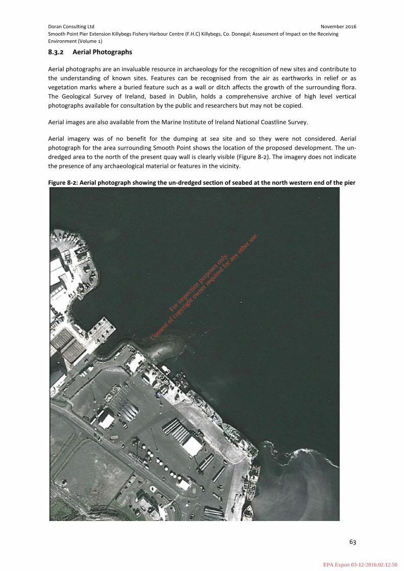
Doran Consulting Ltd November 2016
Smooth Point Pier Extension Killybegs Fishery Harbour Centre (F.H.C) Killybegs, Co. Donegal; Assessment of Impact on the Receiving
Environment (Volume 1)
63
8.3.2 Aerial Photographs
Aerial photographs are an invaluable resource in archaeology for the recognition of new sites and contribute to
the understanding of known sites. Features can be recognised from the air as earthworks in relief or as
vegetation marks where a buried feature such as a wall or ditch affects the growth of the surrounding flora.
The Geological Survey of Ireland, based in Dublin, holds a comprehensive archive of high level vertical
photographs available for consultation by the public and researchers but may not be copied.
Aerial images are also available from the Marine Institute of Ireland National Coastline Survey.
Aerial imagery was of no benefit for the dumping at sea site and so they were not considered. Aerial
photograph for the area surrounding Smooth Point shows the location of the proposed development. The un-
dredged area to the north of the present quay wall is clearly visible (Figure 8-2). The imagery does not indicate
the presence of any archaeological material or features in the vicinity.
Figure 8-2: Aerial photograph showing the un-dredged section of seabed at the north western end of the pier
For
insp
ectio
n pur
pose
s only
.
Conse
nt of
copy
right
owne
r req
uired
for a
ny ot
her u
se.
EPA Export 03-12-2016:02:12:50
Doran Consulting Ltd November 2016
Smooth Point Pier Extension Killybegs Fishery Harbour Centre (F.H.C) Killybegs, Co. Donegal; Assessment of Impact on the Receiving
Environment (Volume 1)
64
8.3.3 Previous Archaeological Investigations
Archaeological fieldwork has been carried out in the town of Killybegs for the period 1985-2013 (Refer to
Technical Appendix 8.1 for more details). The most significant of these, relating to the site were the
archaeological test trenches excavated by Tony Cummins of Aegis Archaeology in November 2001. His program
of investigations, excavated 10 no. archaeological test trenches across the sand spit at Smooth Point. His
investigations revealed that there were no obvious archaeological deposits at Smooth Point.
8.3.4 Shipwreck Inventory
The shipwreck inventory is a database of all marine archaeological sites around the coast (including
shipwrecks). The record includes data on historical wrecks contained in documentary sources such as Lloyd’s
List, Commons Sessions Papers and Historic Newspapers, Cartographic sources and other sources are also used.
Technical Appendix 8.1 details fourteen vessels recorded by the inventory as having been lost in, off or near
Killybegs, County Donegal.
8.3.5 The Ports and Harbours Archive
The following is a series of details relating to Killybegs as contained in the ports and harbours archives;
‘Memorial’ to complete 2 piers begun by locals, list of subscribers, Engineers, with report specifications.
Memorial to extend Rogers quay in Killybegs.
1836 ‘Killybegs harbour and inlets branching off are well sheltered, the depth of the high water is 4- 7
fathoms. The quay does not extend far enough to be useful at times’.
1st Report of Commission of Enquiry into state of Irish Fisheries. Dublin 220
1836 ‘Killybegs was a royal borough and has an extensive liberty. Its Lough and harbour is the safest on this
coast; and several hundred sail of vessels have been known to be there at one time buying and curing
herring.’
Mr. Nimmo’s coast survey of Ireland for the Commission of Irish Fisheries. P. 70.
1840 ‘Killybegs formerly one of the principal Irish seaports and still deserving of being such from its fine and
safe harbour, and eligible situation for commerce and manufactures. The harbour is nearly circuitous, well
sheltered and accessible to ships of any burden. Vessels not drawing more than 10 feet may anchor near
the town, but on the west side where there is good anchorage they may safely ride in 50 feet of water.
Marmion 1840-p. 422
1839-96 Construction of fishery pier.
OPW archives Piers and Harbours
1896 Construction of new pier.
Ref. 5448 Board of Trade; Harbour Improvements.
1900 ‘Killybegs Harbour’
(H7971)
Annotated Admiralty Chart of Killybegs Harbour.
Ref: 8552.1 Board of Trade, Green Series.
For
insp
ectio
n pur
pose
s only
.
Conse
nt of
copy
right
owne
r req
uired
for a
ny ot
her u
se.
EPA Export 03-12-2016:02:12:50

Doran Consulting Ltd November 2016
Smooth Point Pier Extension Killybegs Fishery Harbour Centre (F.H.C) Killybegs, Co. Donegal; Assessment of Impact on the Receiving
Environment (Volume 1)
65
8.3.6 Archaeological Field Surveys
A large amount of work has been carried out on the terrestrial aspect of the Smooth Point development,
however little had been completed on the submarine side. As a result, and in order to fully investigate the
submarine area surrounding Smooth Point, a geophysical survey of the areas was completed. No equivalent
survey was undertaken for the dumping at Sea site as the area had previously been the subject of an
archaeological assessment and there were no deposits or features noted in the area. Consequently, it was not
deemed necessary to resurvey the dumping at sea site.
The marine geophysical survey was undertaken at Smooth Point was carried out under Detection Device
Licence 15R0150 in February 2016. It comprised a high resolution side scan sonar, marine magnetometer and
sub bottom profiler survey.
The side scan sonar survey data indicated that the seafloor of the survey area consisted of medium to coarse
sand and gravel. The gravel bar that makes up Smooth Point could be differentiated from the surrounding
seafloor due to the high reflectivity noted in the sonar trace. This was partly due to the shallower water depths
in the vicinity of Smooth Point and the coarser nature of the sediment that made up Smooth Point itself.
There were no archaeological anomalies noted in the sonar data during processing. The only seabed features of
note in the area seem to be possibly related to ship movements. These features consisted of possible keel
scour or anchor drags associated with ships berthing and subsequent departure from the harbour.
The magnetometer survey took place at the same time as the side scan sonar survey. The magnetometer was
towed at a distance of 25m from the survey vessel to ensure the vessel itself had no impact on the
magnetometer data.
The proximity of the survey area to the existing harbour wall and large fishing vessels prevented the
magnetometer from acquiring any useable data. The magnetometer could not differentiate between the
ambient magnetic field of the area and that induced by the large steel fishing trawlers and the harbour
structure. This magnetic masking in effect washed out the magnetometer data rendering it largely un-usable in
that area.
A total of 14 lines of sub bottom data were collected during the survey. These consisted of 10 lines parallel to
the harbour wall and 4 lines perpendicular to the harbour wall. The sub bottom data collected was of good
quality. A clear differentiation between the seafloor and another underlying layer can be seen in the sub
bottom traces. No discernible archaeological anomalies were recorded by the sub bottom profiler. In most
cases the trace consists of the seafloor overlying another reflector. It is possible that this reflector is bedrock or
a layer of more consolidated sand or gravel as it seems that in the immediate area surrounding Smooth Point
that this layer continues upward to form the seabed surface (Refer to Technical Appendix 8.1 for more details).
8.4 Impact Assessment
The baseline environment has been divided into four categories, each of which is addressed individually. These
are as follows:
1. Cultural heritage assets listed by DAHG and National Museum of Ireland;
2. Known wrecks and obstructions as per Shipwreck Inventory/Receiver of Wreck and UKHO;
3. Unrecorded maritime archaeological sites, features and deposits identified through assessment of
geophysical and hydrographic data; and
4. Areas of archaeological potential.
For
insp
ectio
n pur
pose
s only
.
Conse
nt of
copy
right
owne
r req
uired
for a
ny ot
her u
se.
EPA Export 03-12-2016:02:12:51
Doran Consulting Ltd November 2016
Smooth Point Pier Extension Killybegs Fishery Harbour Centre (F.H.C) Killybegs, Co. Donegal; Assessment of Impact on the Receiving
Environment (Volume 1)
66
8.5 Predicted Impacts
The development site at Smooth Point is located in close proximity to a series of recorded archaeological sites
many of which are associated with St Catherine and an early ecclesiastical foundation. There is also a recorded
Fulachta Fiadh and a series of seventeenth century buildings.
Notwithstanding this, the previous archaeological site survey carried out in the area including the programme
of archaeological testing indicated that there were no archaeological materials at the subject site.
The dumping at sea site was the subject of a programme of archaeological survey and assessment in 2002 and
no archaeological material was noted.
Fourteen vessels have been recorded as been lost in off or near Killybegs harbour but none were recorded for
the dumping at sea site. Two stray archaeological finds have also been recorded from the vicinity of the
harbour but none were recorded for the dumping at sea site.
Five structures on Rough Point were excavated prior to the original pier development and were shown to be of
seventeenth century date. A number of burnt mounds, one with an associated trough have been identified
during test excavations close to Rough Point, indicate Bronze Age activity in the area.
Archaeological test trenches excavated at the Smooth Point spit, prior to the original pier development did not
reveal any archaeological features and a number of timbers were also shown to be not archaeological in
nature. Two underwater surveys conducted within the broad harbour area which included metal detecting also
did not reveal any features of an archaeological nature.
As indicated, the proposed dredging activities associated with the proposed pier extension is located within an
area of known archaeological potential, however all previous surveys in the area indicated that there were no
archaeological materials.
Similarly, the previous archaeological assessment of the dumping at sea site, indicated that there were no
archaeological remains or features present.
Notwithstanding this, there is potential for works at Smooth Point to disturb previously unrecorded materials
associated with the nearby Bronze Age activity or intense early medieval settlement and seventeenth century
settlement. Although the geophysical survey did not appear to record the presence of any shipwrecks or
associated materials, the number of 17 recorded shipwrecks for Killybegs harbour indicates that there is a
possibility that the works may have the potential to disturb features associated previously unknown
shipwrecks.
Previous surveys have indicated that there are no archaeological features or materials at the dumping at sea
site. As a result, the likelihood of the sediment dumping operations having the potential to impact
archaeological material or features is low.
8.6 Mitigation Measures
Based on the results of the program of impact assessment, it is considered that the potential for the dumping
at sea operations to have an impact on archaeological material and/or features is low. Consequently, it is
suggested that no further mitigation measures should be required.
The development at Smooth Point is located in an area of high archaeological significance, where there is a
potential for the development works to impact previously unrecorded archaeological material. Although
previous field surveys have not located any archaeological materials in the area, the potential remains. As a
For
insp
ectio
n pur
pose
s only
.
Conse
nt of
copy
right
owne
r req
uired
for a
ny ot
her u
se.
EPA Export 03-12-2016:02:12:51

Doran Consulting Ltd November 2016
Smooth Point Pier Extension Killybegs Fishery Harbour Centre (F.H.C) Killybegs, Co. Donegal; Assessment of Impact on the Receiving
Environment (Volume 1)
67
result, it is recommended that any groundworks associated with Smooth Point should be monitored by a
suitably qualified archaeologist.
For
insp
ectio
n pur
pose
s only
.
Conse
nt of
copy
right
owne
r req
uired
for a
ny ot
her u
se.
EPA Export 03-12-2016:02:12:51

Doran Consulting Ltd November 2016
Smooth Point Pier Extension Killybegs Fishery Harbour Centre (F.H.C) Killybegs, Co. Donegal; Assessment of Impact on the Receiving
Environment (Volume 1)
68
9 CUMULATIVE IMPACTS
9.1 Introduction
This chapter addresses the assessment of potential cumulative impacts associated with the proposed
development; the aim being to identify if any significant cumulative environmental impacts could occur as a
result of this proposed development option.
Consideration has been given as to whether cumulative impacts could occur in two distinct ways:
1. What interactions exist between topic areas and whether any of the individual impacts will combine to
create a cumulative impact within the proposed development that is greater than the sum of the
individual effects; and
2. Whether cumulative impacts could occur as a result of other nearby developments interacting with
the proposal to create a wider or indirect impact.
9.2 Methodology
In terms of the potential for cumulative effects, consideration has been given as to whether they could occur in
three ways:
i. The cumulative effects of the proposed development with other developments that are planned or committed within the local or regional area;
ii. The potential cumulative effects of the construction and operation of the development with existing operations within the surrounding area; and
iii. The cumulative effect of the interaction of a combination of predicted effects on a particular receptor; this is also covered to some extent within each chapter of the AIRE.
9.3 Assessment
It has been have identified that there are no other planned or committed developments within the surrounding
area that could have the potential for a cumulative impact when considered in conjunction with the proposed
upgrade to the existing harbour at Killybegs.
For
insp
ectio
n pur
pose
s only
.
Conse
nt of
copy
right
owne
r req
uired
for a
ny ot
her u
se.
EPA Export 03-12-2016:02:12:51

For
insp
ectio
n pur
pose
s only
.
Conse
nt of
copy
right
owne
r req
uired
for a
ny ot
her u
se.
EPA Export 03-12-2016:02:12:51