smittle cave - kansas city area · pdf filesmittle cave plus caves of barbuda, ... david...
TRANSCRIPT
The The Kansas City Area Grotto
Volume 20Issue 3November 2006
Smittle CaveplusCaves of Barbuda, High Guads Restoration, Green�s Cave & Little Hamilton Cave, Fall 2006 MVOR & Sandy Dome Cave, Three Creeks Conservation Area,and Geronimo Springs Cave
Smittle CaveplusCaves of Barbuda, High Guads Restoration, Green�s Cave & Little Hamilton Cave, Fall 2006 MVOR & Sandy Dome Cave, Three Creeks Conservation Area,and Geronimo Springs Cave
The Guano2
December 16KCAG Christmas Party & Dinner � Saturday, 6:00 p.m. at the home of Rick and Kay Hines,16525 Orchard Lane, Stilwell, KS 66085.Directions: From 159th and Mission Rd., go south0.7 miles to Orchard Lane. Turn left (east) onOrchard Lane. It�s the second house on left.Meat and drinks provided. Bring a dish to share.RSVP Rick at 913.897.4258 or rickhines ataol.com.
January 10KCAG monthly meeting � 7:00 p.m. at theMagg Conference Center on the UMKCcampus, at the corner of Volker and Cherry.
February 10Hunter�s Cave trip � Three Creeks ConservationArea, about five miles south of Columbia, MO.We�ll probably drive to Columbia in themorning, visit the cave, and then return home,all on the same day. However, if the weathercooperates, this trip could also involve visitingother caves in the vicinity (and possiblycamping overnight). Details to be determinedcloser to the trip date. It all depends on theweather. This should be considered an experi-enced caver trip. The entrance passage has awatercrawl with only a few inches of air. Allparticipants should be prepared to bring achange of clothes for the long uphill walk backto the trailhead (so a backpack is recom-mended). If you�re interested in this trip, contactGary Johnson by e-mail.
February 14KCAG monthly meeting � 7:00 p.m. at theMagg Conference Center on the UMKCcampus, at the corner of Volker and Cherry.
EventsTable of Contents
Smittle Cavetrip report by Gary Johnson � photos by Rick Hines, Steve Potter, and Kathleen Holemn
page 4
Fall 2006 MVORtrip report by Gary Johnson � photos by Steve Potter, Laurel Dunn, and Kathleen Holeman
page 10
High Guads Restorationtrip report and photos by Jerry Cindric
page 13
Jerry�s Barbuda Chroniclestrip report and photos by Jerry Cindric
page 16
Floating the Meramectrip report by Gary Johnson � photos by Gary Johnson and Jean-Philippe Rey
page 21
Three Creeks: Seven Year Itchtrip report and photos by John McGuire
page 28
Geronimo Springs Cavetrip report by Andy Isbell � photos by Bill Gee
page 30
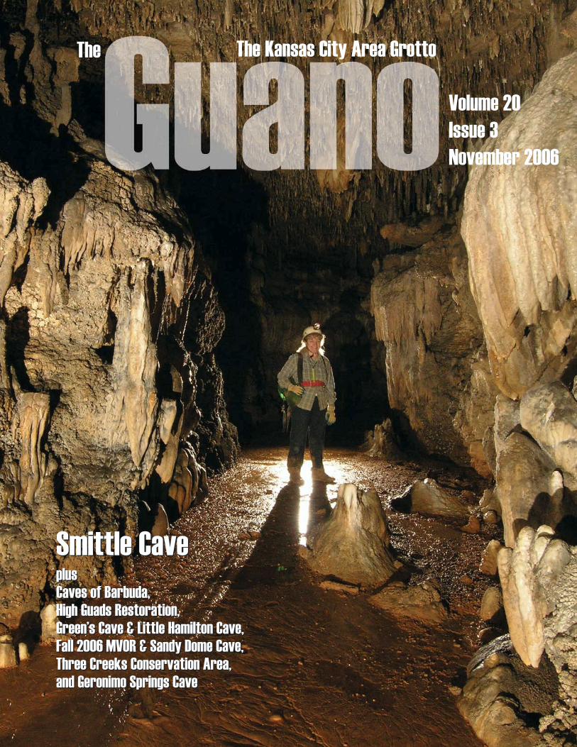
Cover photoLorely Lather in the Formation Passage of Smittle Cave. This passage was part of thevisitor trail when the cave was operated commercially by the Smittle family from the 1920sthrough the 1950s. Photo by Rick Hines.
In the Next IssueKCAG performs clean-upwork on the grounds atOzark Underground Laband visits Tumbling CreekCreek ... a trip with Dr.David Ashley and Jonathan Beard to Smallin Cavein search of cave crayfish ... Jerry Cindric joinsChuck Bitting of the NPS on a visit to CorkscrewCave in Arkansas to monitor bat usage ... JerryCindric visits TAG caves ... and much more.(Crayfish photo by Dr. David Ashley.)
The Guano 3
The GuanoNovember 2006, Vol. 20, Issue 3
The Guano is published on an irregular schedule as
dictated by the trip reports submitted to the editor.
Submit articles via e-mail to the editor:
[email protected]. Preferred file format for trip
report attachments: Microsoft Word. Multiple photos
are typically required for each trip report.
Guano subscription rate for nonmembers: $6.00 annu-
ally. Electronic: FREE.
President: Sam Clippinger ([email protected])
V.P./Treasurer: Bill Gee ([email protected])
Secretary: Gary Johnson ([email protected])
Web Master: Sam Clippinger ([email protected])
Editor: Gary Johnson ([email protected])
Copy editors: Bill Gee & Pam Rader
The Kansas City Area Grotto is affiliated with the
National Speleological Society and the Missouri
Speleological Survey. In addition, KCAG is a founding
member of the Missouri Caves & Karst Conservancy.
Meetings are held monthly. Check www.kcgrotto.org
to determine the dates.
Annual Dues: $15 for full members (three caving trips
with KCAG, nomination, and vote of membership
required.)
NCRC Callout number � Emergency use only: Central
Region (502) 564-7815. This number may be used for
cave rescue emergencies in the states of Illinois,
Indiana, Iowa, Kentucky, Michigan, Missouri, Ohio,
and Wisconsin.
In early 2006, KCAG monthly meetings were sparsely attended. Maybe a half dozenpeople would show up at the Magg Conference Center. The implications were
discouraging. How much longer could the grotto continue when interest in grottomeetings was waning? As absurd as it might sound, I was the newest KCAG memberregularly attending meetings, and I've been around since 2002. Did the grotto have afuture?
Since then, however, there has been a resurgence of interest in the grotto. Newpeople have started attended meetings, some completely new to caving, somemoving to Kansas City after caving elsewhere, and even some long AWOL membershave returned. And once again the grotto's future looks good. However, this resur-gence of interest in the grotto is also pure happenstance. We didn't do anything toaddress the problem. Rather, the solution found us, which means the underlying issuescontributing to diminished interest in the grotto still exist and may once again in thenot-so-distant future begin eating away at meeting attendance.
The life blood of any grotto is the flow of new members. Without a flow of newmembers, grottos dry up and die. Unlike some grottos, where a nearby university helpssupply a constant flow of new members, we have no university connection in KansasCity. So it's especially important that we encourage people who show an interest incaving. In addition, we must help foster attitudes and situations in which cavers canmake contributions to the caving community. KCAG can't make any contributions tothe caving community if we have no members participating in projects.
In the pages of this issue of The Guano, you'll see several new faces, and the trend willcontinue in the next issue with a work trip to Ozark Underground Laboratory. It's a trendI hope continues far into the future.
Best,
Gary JohnsonThe Guano editor
MessageEditor
A From
the
Ever since I started attending KCAGmeetings in 2002, I�d heard stories ofSmittle Cave, but over the past four
years, no one had set up a trip to Smittle,until now, when both Peddgie Heinz ofKCAG and Steve Potter of PEG acquiredseparate permits for trips just a few daysapart.
Peddgie�s group visited the cave onSeptember 24th. Most of the photos accom-panying this article come from Peddgie�s trip(including this issue�s cover), when RickHines brought his photo equipment.
I went to Smittle with Steve Potter�sgroup. He had set up the Smittle trip as awarm-up before the Fall 2006 MVOR. So wemet at John Alva Fuson, M.D., ConservationArea late on a Thursday afternoon. I arrivedfirst and drove to the camping area by LittleSmittle Cave and found it was already occu-pied by a group from a home for troubledboys. The leaders were nice guys who said
it�d be okay for us to camp there, but Ithought it might be best to look elsewhere. Iknew there was another camping area in theconservation area, so I went to check it out.
The second camping area wasn�t as nice asthe one by Little Smittle, which is moresecluded and shaded. In contrast, the secondcamping area was out in the open, with acouple trees beside it to the east and a roadin front on the west. I�ve seen old photos ofa farmhouse sitting on this site. This mayhave been where the Smittle family, the cave�snamesake, once lived, but most signs of theold farmhouse are gone.
Within 50 yards of the camping area isLowell Cave. A wide trail leads to the cave�sentrance. More on this cave in a minute �
I spent most of the next hour trying tomake telephone calls so the others wouldknow where to find me, while two armadillosrummaged through the leaves and brush,making quite a racket. But I�d left word at the
other campsite where I�d be. Soon enough,the others started to arrive�first, StevePotter and Jan Gerling, and then EricHertzler. Later, Dan Myatt arrived, thenKathleen (Steve�s wife, who had a singing gigearlier that evening at Lake of the Ozarks)and several hours later the Dunns arrived. Soour group was complete.
Before it got too late, we checked outLowell Cave. I hadn�t seen a map of the cave,but I�d read somewhere that you have to gothrough a long, long belly crawl not far fromthe entrance (and eventually, it opens up). Weweren�t going to do any belly crawling. Wewere just interested in a little look-see. Theentrance is fairly large and the passage insidehas a high ceiling, at least 20 feet high. Wecontinued into the passage as the ceilingdescended to stoop-walking height, but there
The Guano4
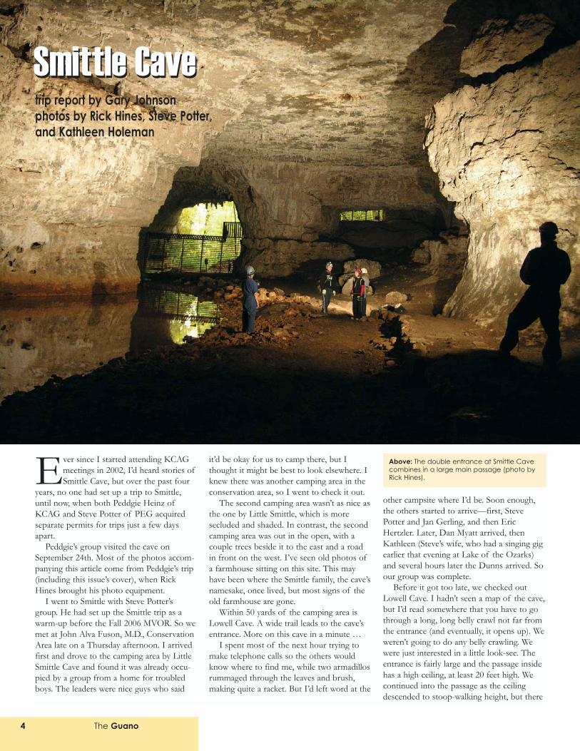
Above: The double entrance at Smittle Cavecombines in a large main passage (photo byRick Hines).
Smittle Cavetrip report by Gary Johnsonphotos by Rick Hines, Steve Potter, and Kathleen Holeman
Smittle Cave
The Guano 5
was a narrow ceiling channel thatcould be walked. This channel wasinteresting because entrenchedmeanders were apparently respon-sible for cutting down through therock. The channel followed atorturous route that could befollowed for a couple hundredfeet. At one point it looked like itmight have been possible to climbup one of the walls of the channelto a higher level of the cave.
We followed the channel as faras we could. It became intermit-tent and required some minorhands-and-knees crawling to findthe channel sections. We soonreached the point where thechannel disappeared altogetherand crawling was the only way tocontinue. Here is where we turnedaround. We were probably about300 feet into the cave. I�ll have toreturn and investigate this cavefurther.
On Friday morning, Steve, Jan,and Kathleen drove to the conser-vation area office to pick up thekey for Smittle. Once they gotback, we geared up for caving.Our party broke into two groups.Kathleen would lead a small groupinto Little Smittle Cave, while therest of us planned for a moreaggressive trip in Smittle. Stevehad been in Smittle before, but hehad not been to the WaterfallRoom. So this time the Waterfall Room wasour target destination. I had talked toJonathan Beard about this room, and it�squite notorious because this is the place thatyou continue further in the cave by climbingup the left wall, onto a small ledge. Then youjump across to the right wall, over about a15-foot drop.
The group from the home for troubledboys was packing up when we arrived. LittleSmittle was only about 100 yards away. Theroad to Smittle is gated, but the same keythat opens the cave gate also opens the roadgate. So everyone piled into the back of mypickup, and then we bounced down the roadfor about a half mile to the cave entrance.
I had read about Smittle Cave in bothMissouri: The Cave State by Dwight Weaverand Caves of Missouri by J. Harlan Bretz, aswell as Kenneth Thomson�s description fromthe Spring 1981 MVOR Handbook. So thefollowing is a short description of the caveculled from these sources.
Smittle Cave has been known for at least150 years. A family by the name of Smittleused to farm the land nearby. Somemembers of the family explored the caveand even reported that they found the bonesof an Indian encased by flowstone in theWater Passage. (Bretz reported this story;however, I asked Jonathan Beard about theskeleton and he said he had never seen itand didn�t know where it might be�if infact it ever existed.)
In the 1920s, the Smittle family turnedthe cave into a commercial venture. Theybuilt a dam near the entrance with the inten-tion of creating a lake in the main passagethat could be navigated by way of flat-bottom boat. This plan didn�t work very welland was eventually discarded in favor ofbuilding a boardwalk along the left side of
the main passage forover 1,000 into the cave.The remains of thisboardwalk are stillvisible today. The hori-zontal planks are longgone, but the verticalsupport posts remain,blackened and rottingbut still in place.
The commercial toursvisited the FormationPassage (a dirt walkwaylined with stones is stillvisible at the beginningof the passage), theMeander CanyonPassage (for a couplehundred feet, where thepassage is a high canyonthat can easily bewalked), and the BallDiamond (a wide, dryroom with a ceiling onlyabout five-feet high).The commercial tourwent as far back as theJumping-off Place,which is at the far sideof the Ball Diamond. Inaddition, the commercialtour reportedly enteredthe Water Passage, but Ifind it hard to believethat the tour entered thispassage: almost immedi-ately the mud is deep
and crawling is required. Maybe there was aplatform built at the entrance of thispassage, but if so, all evidence is long gone.The Smittles operated the cave commerciallyuntil the 1950s, when diminishing returnsforced them to concentrate on their farmingoperations and close the cave. Since then thecave has not reopened commercially.
The farm land was eventually purchasedby the Missouri Department ofConservation and turned into the John AlvaFuson, M.D., Conservation Area. The area isrelatively small as conservation areas go, only1280 acres. It�s roughly shaped like an L,with the two parts of the letter each beingabout a mile wide and two miles long. ParkCreek cuts through the lower portion of theL. The bottom lands here are about aquarter mile wide. This area was undoubt-edly farmed heavily by the Smittle family.The park map shows a hiking trail system inthe western section of the conservation area(the upright part of the L), but I haven�tread any descriptions of this trail so I don�t
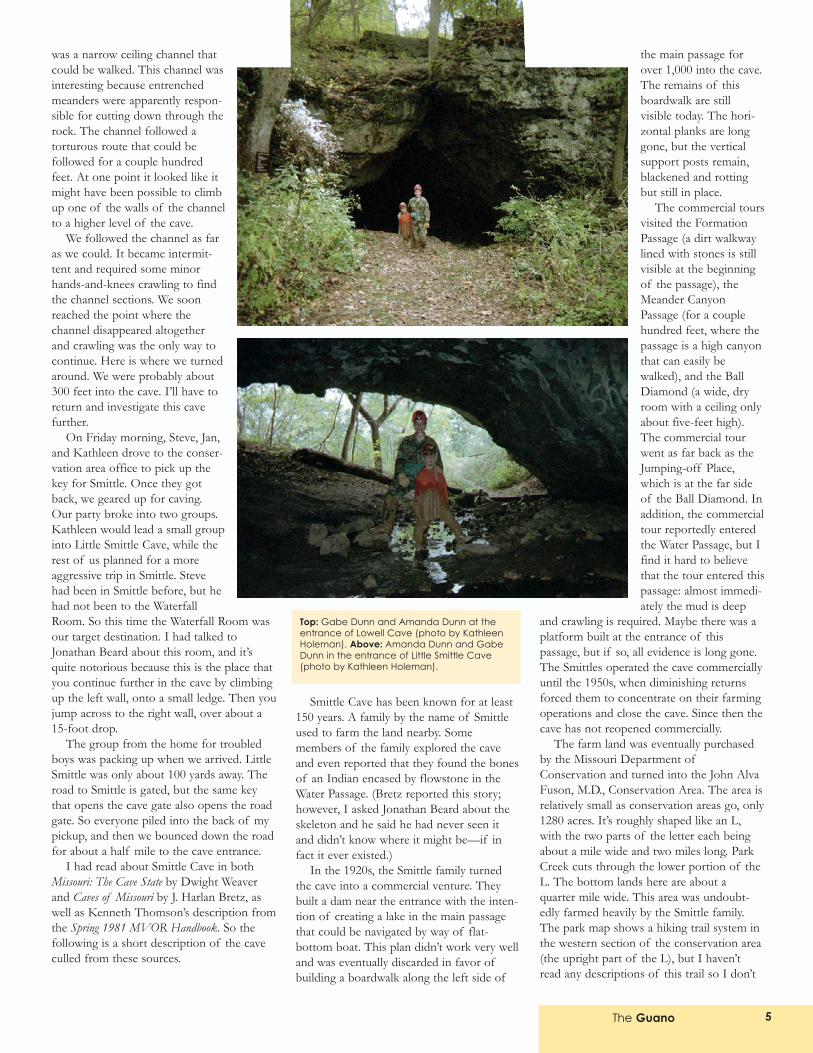
Top: Gabe Dunn and Amanda Dunn at theentrance of Lowell Cave (photo by KathleenHoleman). Above: Amanda Dunn and GabeDunn in the entrance of Little Smittle Cave(photo by Kathleen Holeman).
The Guano6
know what to expect. From the map, it lookslike the trail heads up to a ridge at a gentleincline, gaining about 150 feet in elevationfrom the trailhead at the Little Smittle camp-ground.
Both Little Smittle and Smittle Cave areon the west side of the Parks Creek valley.Little Smittle is reportedly muddy, with fewformations. But Kathleen and her group,including six-year-old Gabe Dunn, had funexploring it. Gabe was excited about caving.It was fun to see someone so young who wasso interested in caves.
Smittle Cave has a double entrance. Theleft entrance is up high on a talus slope. Thisentrance is protected by a heavy fence. (Wedidn�t inspect this entrance closely, but Idoubt the fence has a gate.) The rightentrance is at creek level. A heavy gate with asmall door protects the lower half of theentrance, allowing bats to use the upper half.A horizontal extension keeps people fromsimply crawling over the top. This entrance isabout 30 feet high and 60 feet wide.
Everyone geared up, and Steve opened thegate. We stepped through. The entrancepassage is quite large. The passages from thetwo entrances join to form an area about 120feet wide. From here the passage narrowsslightly, to about 70 feet wide with a 30-foothigh ceiling. The cave maintains these dimen-
sions (narrowing gradually) for about 2,000feet.
From the map, it looked like we could beencountering long stretches of standingwater up to three feet deep. I�d heard storiesabout how nasty this passage can be. But thepast several weeks had been pretty dry, so wedidn�t have much trouble navigating the mainpassage. The first 300 feet follow a dry footpath. Then remains of the boardwalk can beseen as the mud begins. We plowed forwardthrough the mud, looking for the areas thatoffered firmer footing. We made a fewmistakes and occasionally stumbled into kneehigh water and mud, but usually the mudwasn�t too bad.
We passed the Formation Passage on theleft. Steve wanted to focus all our energy ongetting to the Waterfall Room. So we trudgedforward. If we had time, we�d visit theFormation Passage later. We passed theMeander Passage on the right. Same storyhere. If we had time, later.
Near the Ball Diamond and a little over2,000 feet into the cave, the character of thecave changes. Here, the creek disappearsalong the left side of the passage. For severalhundred feet, the stream goes AWOL beforeagain appearing beyond the Ball Diamond.Where the creek disappears, a side passageon the left is obvious. Well, it�s obvious aslong as you haven�t climbed the slope up intothe Ball Diamond, which sits on the right.We kept our attention to the far left, knowingthat�s where we�d find the Water Passage.
A hand-lettered sign marks this sidepassage and strongly suggests that anyoneentering the passage should bring along aspray bottle and brush with which they canclean any formations that get splattered withmud. A bucket full of brushes and spraybottles sat by the sign. We loaded up withbrushes and spray bottles and steppedforward into the infamous Water Passagemud.
Now, I�ve been down Lower ThunderRiver in Carroll Cave, but that mud ain�t gotnothing on Smittle�s Water Passage. The mudin Lower Thunder River at least has abottom. The Water Passage mud remainsslushy far deeper. You absolutely must keepyour momentum moving forward. As long asyou can do that, you�re okay. But if you standin one place for more than a second � yousink down to your thighs. And then everystep forward becomes a struggle. On the waythrough the Water Passage, everyone did agreat job of moving forward. That meant wedidn�t have the opportunity to really appre-ciate the profuse display of flowstone thatfrequently covers the walls of this passage.
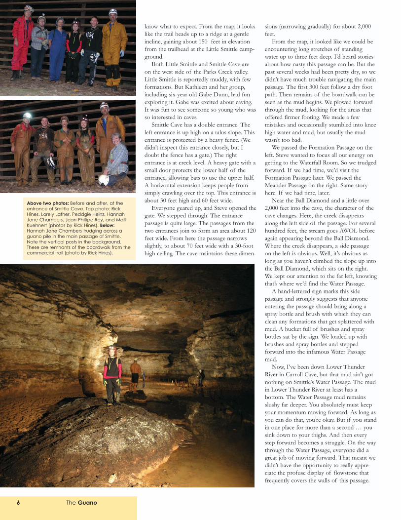
Above two photos: Before and after, at theentrance of Smittle Cave. Top photo: RickHines, Lorely Lather, Peddgie Heinz, HannahJane Chambers, Jean-Phillipe Rey, and MattKuehnert (photos by Rick Hines). Below:Hannah Jane Chambers trudging across aguano pile in the main passage of Smittle.Note the vertical posts in the background.These are remnants of the boardwalk from thecommercial trail (photo by Rick Hines).
The Guano 7
We curved around columns and stalagmites,ducking under stalactites and other forma-tions on the ceiling. Occasionally, we had tocrawl for a few feet, but for the most part,this was walking passage. Or rather sloshingpassage.
This passage continues south from themain passage for about 1,000 feet before itcurves to the right (west). At this point,
you�re about 150 feet away from the pointwhere you must make a left and leave theWater Passage. I�d talked to Jonathan Beardabout finding this area and he gave me sometips. I knew when to start looking up highfor a way out of the water. And soon wefound a twisty crawl that headed up. PeddgieHeinz�s group earlier in the week missed thisturn and ended up in the Meander Passage,
although they eventually made a left and mayhave entered the Waterfall Passage for a fewhundred feet before stopping short of theWaterfall Room.
We crawled up through breakdown andnarrow tubes until we emerged in the DomeRoom. Here, the map completely agreed withwhat we were seeing, so I knew we were inthe right place. At this point, we were about300 feet from the Waterfall Room. To getthere, we would have to negotiate severalsmall passages. After only about 100 feet intothe Waterfall Room Passage, we had to makea choice: go to an upper passage or stay low.Most people in our group went up. Beingsomewhat contrary, I decided to stay low, andafter a little squeeze around a nice three-foothigh stalagmite in a little alcove, I foundmyself in walking passage. Meanwhile, theothers were struggling with an upper passagethat occasionally intersected the passage Iwas in, leaving them with no alternative thanto climb back down. This passage remainedwalking height for 100 feet as it meanderedleft and right. But then we were back in anarrow crawling passage. That continued foranother 100 feet and then I popped up into aroom with a high ceiling.
As I stood up, I saw two thin lines againstthe ceiling. Ropes. This was it. This was theentrance to the Waterfall Room and I waslooking at the place where you jump acrossfrom the left wall to the right. JonathanBeard told me that ropes marked this place,but he also warned me not to rely on theropes. They were potentially a couple decadesold. This wasn�t quite what I expected. I�dsomehow thought we�d be jumping across achannel by the waterfall. No, the waterfallwas on the other side of the room. Now themap made sense. Sometimes you have toactually be standing in a cave room in orderto understand what a cave map is attemptingto depict. This is one of those instances.
I stepped forward. I was in a little canyononly about 20 feet long. The ledge on the leftwall was about 15 feet high. It was a smallledge with little headroom. The right ledge,where we would jump to, looked bigger.About three feet of air separated the twoledges. This little canyon led forward to alarger space, about 20 feet across thatslumped down to the right. The far wall wascovered in flowstone, a light beige in color.
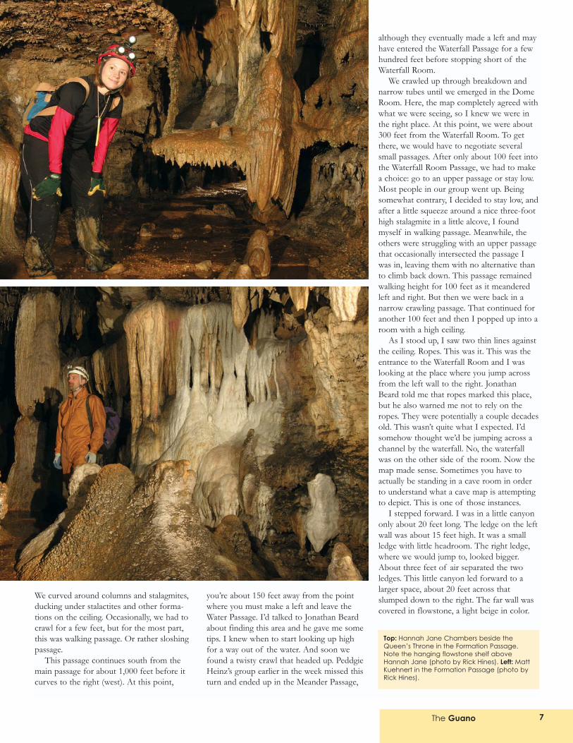
Top: Hannah Jane Chambers beside theQueen�s Throne in the Formation Passage.Note the hanging flowstone shelf aboveHannah Jane (photo by Rick Hines). Left: MattKuehnert in the Formation Passage (photo byRick Hines).
The Guano8
The floor slumped to a clear pool of waterthat looked at least a couple feet deep. Withlittle rain in recent weeks, the waterfall wasnot running, but the room was still veryimpressive. We didn�t go any further than thetop of the slope that leads to the pool. Wedidn�t want to spoil this impressive place withour footsteps. We could only see the far leftportion of the pool, but the map indicated itwas about 25 feet long and 15 feet wide. Ithink it was a little smaller than that when wewere there.
Okay, now what should we do? Can wecontinue? Can we get across the jump? Dowe dare attempt it? How�s everyone feeling?We pretty much came directly to theWaterfall Room. We made no real mistakes.So we were about as fresh as we could havehoped to be. It was time to assess how wewere doing physically. Eric had started theday with an impending case of the commoncold threatening to sap his energy. Now, helooked drained.
Because we totally lacked someone withmuch experience in situations like this, itdidn�t seem wise to go further. I kept imag-ining someone missing the jump and falling15 feet. That seemed a very realistic scenario.
Dan and Jan started looking for alterna-tives. They climbed into a small upperpassage and took off crawling. I waited forseveral minutes, mulling over our choices. Idecided to get a closer look at the jump, so Iclimbed up the left wall and slid belly firstonto a shelf. There wasn�t much room here,just enough to push my body in a shallowniche. I twisted to the left, and pulled myselfforward. Now, I was only about six feet awayfrom the point where I could rise onto myfeet, from the place where you jump. I turnedmy head to the right and saw a large passageon the far side. While the ledge on the left isnarrow with little headroom, on the right, theledge was large with a good-sized passagewaiting for everyone who makes the jump.Assuming everyone could make the jumpacross, could we make the return jump? Yikes!A mass of rock loomed above the ledge.Anyone jumping back would have to shrinkto their knees to avoid bashing their head.This just didn�t look like a good idea. Itlooked like an accident waiting to happen.
Meanwhile, Dan and Jan had returnedwith stories of following a crawlway passagefor about 100 feet. What? How could thatbe? I pulled out the map and saw an upperpassage heading back the direction we came.This was the upper passage that occasionallycriss-crossed with the lower passage. �Thatjust goes back toward the Water Passage,� Iyelled. They seemed convinced that wasn�t
possible, but then I started describing thepassage to them. And they had to admit thedescription matched the passage exactly.
So that meant we either had to make thejump or retreat. Well � with the group wehad, with no one who had been acrossbefore, with no one with much vertical expe-rience, it just didn�t seem wise to go anyfurther. So we retreated. Now we know a
little better what to expect, I suspect, andmaybe we can plan better for our nextattempt (i.e., get someone who knows some-thing about situations like this!).
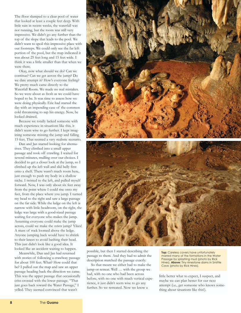
Top: Careless cavers have unfortunatelymarred many of the formations in the WaterPassage by splashing mud (photo by RickHines). Above: Tiny rimestone dams in SmittleCave (photo by Rick Hines).
The Guano 9
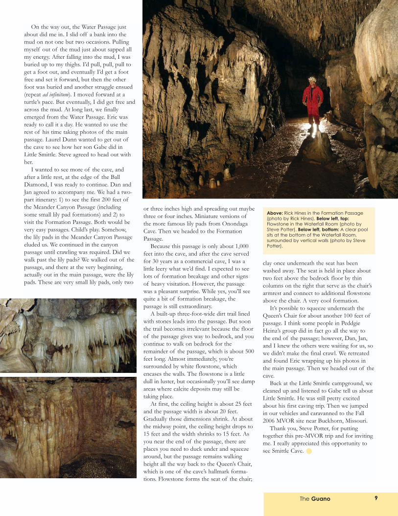
On the way out, the Water Passage justabout did me in. I slid off a bank into themud on not one but two occasions. Pullingmyself out of the mud just about sapped allmy energy. After falling into the mud, I wasburied up to my thighs. I�d pull, pull, pull toget a foot out, and eventually I�d get a footfree and set it forward, but then the otherfoot was buried and another struggle ensued(repeat ad infinitum). I moved forward at aturtle�s pace. But eventually, I did get free andacross the mud. At long last, we finallyemerged from the Water Passage. Eric wasready to call it a day. He wanted to use therest of his time taking photos of the mainpassage. Laurel Dunn wanted to get out ofthe cave to see how her son Gabe did inLittle Smittle. Steve agreed to head out withher.
I wanted to see more of the cave, andafter a little rest, at the edge of the BallDiamond, I was ready to continue. Dan andJan agreed to accompany me. We had a two-part itinerary: 1) to see the first 200 feet ofthe Meander Canyon Passage (includingsome small lily pad formations) and 2) tovisit the Formation Passage. Both would bevery easy passages. Child�s play. Somehow,the lily pads in the Meander Canyon Passageeluded us. We continued in the canyonpassage until crawling was required. Did wewalk past the lily pads? We walked out of thepassage, and there at the very beginning,actually out in the main passage, were the lilypads. These are very small lily pads, only two
or three inches high and spreading out maybethree or four inches. Miniature versions ofthe more famous lily pads from OnondagaCave. Then we headed to the FormationPassage.
Because this passage is only about 1,000feet into the cave, and after the cave servedfor 30 years as a commercial cave, I was alittle leery what we�d find. I expected to seelots of formation breakage and other signsof heavy visitation. However, the passagewas a pleasant surprise. While yes, you�ll seequite a bit of formation breakage, thepassage is still extraordinary.
A built-up three-foot-wide dirt trail linedwith stones leads into the passage. But soonthe trail becomes irrelevant because the floorof the passage gives way to bedrock, and youcontinue to walk on bedrock for theremainder of the passage, which is about 500feet long. Almost immediately, you�resurrounded by white flowstone, whichencases the walls. The flowstone is a littledull in luster, but occasionally you�ll see dampareas where calcite deposits may still betaking place.
At first, the ceiling height is about 25 feetand the passage width is about 20 feet.Gradually those dimensions shrink. At aboutthe midway point, the ceiling height drops to15 feet and the width shrinks to 15 feet. Asyou near the end of the passage, there areplaces you need to duck under and squeezearound, but the passage remains walkingheight all the way back to the Queen�s Chair,which is one of the cave�s hallmark forma-tions. Flowstone forms the seat of the chair;
clay once underneath the seat has beenwashed away. The seat is held in place abouttwo feet above the bedrock floor by thincolumns on the right that serve as the chair�sarmrest and connect to additional flowstoneabove the chair. A very cool formation.
It�s possible to squeeze underneath theQueen�s Chair for about another 100 feet ofpassage. I think some people in PeddgieHeinz�s group did in fact go all the way tothe end of the passage; however, Dan, Jan,and I knew the others were waiting for us, sowe didn�t make the final crawl. We retreatedand found Eric wrapping up his photos inthe main passage. Then we headed out of thecave.
Back at the Little Smittle campground, wecleaned up and listened to Gabe tell us aboutLittle Smittle. He was still pretty excitedabout his first caving trip. Then we jumpedin our vehicles and caravanned to the Fall2006 MVOR site near Buckhorn, Missouri.
Thank you, Steve Potter, for puttingtogether this pre-MVOR trip and for invitingme. I really appreciated this opportunity tosee Smittle Cave.
Above: Rick Hines in the Formation Passage(photo by Rick Hines). Below left, top:Flowstone in the Waterfall Room (photo bySteve Potter). Below left, bottom: A clear poolsits at the bottom of the Waterfall Room,surrounded by vertical walls (photo by StevePotter).
The Guano10
The Fall 2006 MVOR returned to a sitefrom just three years ago, the Shinerscampground near Buckhorn,
Missouri. Hosted by MSM Spelunkers, thispromised to be an excellent MVOR, and weweren�t disappointed. From all the MVORevents that I�ve attended over the past severalyears, this was one of the best organized.The site is great. It�s so big that everyone hasas much room as they want. It�s hard to sayhow many people were there because mostpeople set up their camps back in the treesand hollows. The central area in front of thestage was off limits for camping. So youdidn�t see a sea of tents and RVs. You saw asea of green, with campsites on the farfringes.
I rolled in on Friday afternoon along withseveral car loads of Pony Express Grotto(PEG) cavers. I�d been caving with themearlier in the day, and because few KCAGmembers had voiced any interest at the lastgrotto meeting in coming to this MVOR, Ididn�t expect there to be a KCAG area. OnlyBill Gee from KCAG had indicated he�d bethere. So I camped with PEG. We drovearound the campground and finally picked aplace back near the entrance. Not exactly agood choice even though it was in the QuietArea because heavy metal music blasted fromthe bandstand less than 100 yards away.When Lorin O�Daniell of PEG showed uplater that day, he questioned the wisdom ofour campsite choice and promptly chose toset up his camp further away, where he wassheltered from the bandstand by at least afew trees.
Some grottos reserved pavilions, whichcould be had for a fee, and set up elaboratedecorations. Back at the PEG camp, we setup a pole tent in case it rained. But the poletent was largely irrelevant because theweather was perfect the entire weekend.
My only complaint about the MVOR wasthe heavy metal music. I guess if you host anMVOR you get to pick the music, but whysubject everyone to this stuff? Oh, well. Ibummed some earplugs off of KathleenHoleman and ultimately didn�t really have anytrouble getting to sleep.
Vendor row was a little thin this timearound. Howie�s Harnesses made itscustomary appearance, and later that eveningI spent a little money on new equipment.Other vendor tents included Barnwood Bats,MSS, and several others.
On Friday night, the Howdy Party offeredhot dogs and chips. Bottomless beer cupswere available at registration, so many peoplestood close to the beer wagon, intent ongetting their money�s worth.
On Saturday morning, cave trip signupsstarted early with trips leaving at 9 A.M. Onthe schedule were photo trips to Berry Caveand York Cave; recreational trips to Perkins,Skaggs, Rattlesnake, Sandy Dome,Kiesewetter, and Finley Cave #2; and abiology trip to Merrill Cave. In addition,Conor Watkins offered a return engagementof his geology tour.
Top two photos: Scenes from the MVORbanquet (photos by Steve Potter). Next tobottom: Gabe Dunn, Steve Potter, andKathleen Holeman (photo by Laurel Dunn).Bottom: The MVOR bonfire roared to impressiveheights. Left to right: Kathleen Holemn, DanMyatt, Steve Potter, Gabe Dunn, Jan Gerling,and Lorin O�Daniell (photo by Laurel Dunn).
Fall 2006 MVORtrip report by Gary Johnsonphotos by Steve Potter, Laurel Dunn, and Kathleen Holeman
The Guano 11
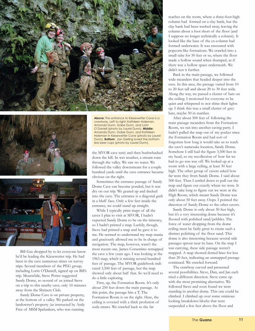
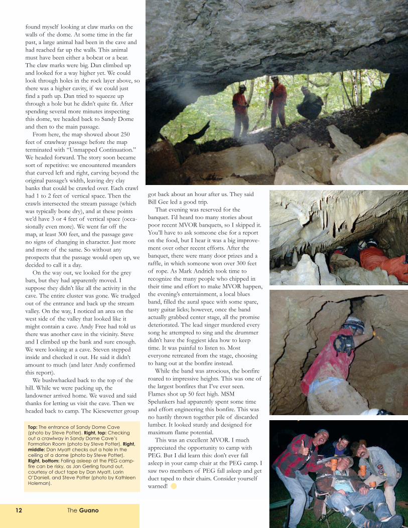
Bill Gee dropped by to let everyone knowhe�d be leading the Kiesewetter trip. He hadbeen in the cave numerous times on surveytrips. Several members of the PEG group,including Lorin O�Daniell, signed up on Bill�strip. Meanwhile, Steve Potter suggestedSandy Dome, so several of us joined Steveon a trip to this nearby cave, only 10 minutesaway from the Shriners Club.
Sandy Dome Cave is on private property,at the bottom of a valley. We parked on thelandowner�s property (as instructed by AndyFree of MSM Spelunkers, who was running
the MVOR cave tent) and then bushwhackeddown the hill. In wet weather, a stream runsthrough the valley. We saw no water. Wefollowed the valley downstream for a couplehundred yards until the cave entrance becameobvious on the right.
Sometimes the entrance passage of SandyDome Cave can become ponded, but it wasdry on our trip. We geared up and duckedinto the cave. The entrance is a diagonal gashin a bluff face. Only a few feet inside theentrance, we could stand up straight.
While I typically print maps of all thecaves I plan to visit at MVOR, I hadn�texpected Sandy Dome to be on the itinerary,so I hadn�t printed a map. Luckily, though,Steve had printed a map and he gave it tome. He seemed to understand my map maniaand graciously allowed me to be in charge ofnavigation. The map, however, wasn�t themost recent one. James Corsentino remappedthe cave a few years ago. I was looking at the1963 map, which is missing several hundredfeet of passage. The MVOR guidebook indi-cated 3,500 feet of passage, but the mapshowed only about half that. So we�d need todo a little exploring.
First, up, the Formation Room. It�s onlyabout 250 feet down the main passage. Atthis point, the passage hits a T. TheFormation Room is on the right. Here, theceiling is covered with a thick profusion ofsoda straws. We crawled back to the far
reaches on the room, where a three-foot-highcolumn had formed on a clay bank, but theclay bank had been washed away, leaving thecolumn about a foot short of the floor (andI suppose no longer technically a column). Itlooked like the base of the ex-column hadformed underwater. It was encrusted withpopcorn-like formations. We crawled into asmall tube for 50 feet or so, where the floormade a hollow sound when thumped, as ifthere was a hollow space underneath. Wedidn�t test it further.
Back in the main passage, we followedwide meanders that headed deeper into thecave. In this area, the passage varied from 10to 20 feet tall and about 20 to 30 feet wide.Along the way, we passed a cluster of bats onthe ceiling. I motioned for everyone to bequiet and whispered to not shine their lightsup. I think this was a small cluster of greybats, maybe 50 in number.
After about 500 feet of following themain passage meanders from the FormationRoom, we ran into another caving party. Ihadn�t pulled the map out of my pocket sincethe Formation Room and had sort offorgotten how long it would take us to reachthe cave�s namesake location, Sandy Dome.Somehow I still had the figure 3,500 feet inmy head, so my recollection of how far wehad to go was way off. We looked up at aroom with a large ceiling, at least 30 feethigh. The other group of cavers asked howfar were they from Sandy Dome. I said about500 feet. Then I settled down to pull out themap and figure out exactly where we were. Itdidn�t take long to figure out we were at theHigh Room, which meant Sandy Dome wasonly about 50 feet away. Oops. I pointed thedirection of Sandy Dome to the other cavers.
Sandy Dome is only about 30 feet high,but it�s a very interesting dome because it�sfloored with polished sand/pebbles. Theforce of water dropping from the domeceiling must be fairly great to create such adistinct polishing of the floor sand. Thisdome is also interesting because several sidepassages sprout near its base. On the map Iwas carrying, these side passage weren�tmapped. A map showed dotted lines for lessthan 20 feet, indicating an unmapped passagecontinued. We crawled forward.
The crawlway curved and presentedseveral possibilities. Steve, Dan, and Jan eachtried a different direction. Steve came upwith the most promising alternative. Wefollowed Steve and soon found we werestanding in another dome. This one could beclimbed. I climbed up over some ominouslooking breakdown blocks that weresuspended a few feet above the floor and
Above: The entrance to Kiesewetter Cave is acrawlway. Left to right: Kathleen Holeman,Amanda Dunn, Gabe Dunn, and LorinO�Daniell (photo by Laurel Dunn). Middle:Amanda Dunn, Gabe Dunn, and KathleenHoleman in Kiesewetter Cave (photo by LaurelDunn). Bottom: Jan Gerling loved the bottom-less beer cups (photo by Laurel Dunn).
The Guano12
found myself looking at claw marks on thewalls of the dome. At some time in the farpast, a large animal had been in the cave andhad reached far up the walls. This animalmust have been either a bobcat or a bear.The claw marks were big. Dan climbed upand looked for a way higher yet. We couldlook through holes in the rock layer above, sothere was a higher cavity, if we could justfind a path up. Dan tried to squeeze upthrough a hole but he didn�t quite fit. Afterspending several more minutes inspectingthis dome, we headed back to Sandy Domeand then to the main passage.
From here, the map showed about 250feet of crawlway passage before the mapterminated with �Unmapped Continuation.�We headed forward. The story soon becamesort of repetitive: we encountered meandersthat curved left and right, carving beyond theoriginal passage�s width, leaving dry claybanks that could be crawled over. Each crawlhad 1 to 2 feet of vertical space. Then thecrawls intersected the stream passage (whichwas typically bone dry), and at these pointswe�d have 3 or 4 feet of vertical space (occa-sionally even more). We went far off themap, at least 300 feet, and the passage gaveno signs of changing in character. Just moreand more of the same. So without anyprospects that the passage would open up, wedecided to call it a day.
On the way out, we looked for the greybats, but they had apparently moved. Isuppose they didn�t like all the activity in thecave. The entire cluster was gone. We trudgedout of the entrance and back up the streamvalley. On the way, I noticed an area on thewest side of the valley that looked like itmight contain a cave. Andy Free had told usthere was another cave in the vicinity. Steveand I climbed up the bank and sure enough.We were looking at a cave. Steven steppedinside and checked it out. He said it didn�tamount to much (and later Andy confirmedthis report).
We bushwhacked back to the top of thehill. While we were packing up, thelandowner arrived home. We waved and saidthanks for letting us visit the cave. Then weheaded back to camp. The Kiesewetter group
got back about an hour after us. They saidBill Gee led a good trip.
That evening was reserved for thebanquet. I�d heard too many stories aboutpoor recent MVOR banquets, so I skipped it.You�ll have to ask someone else for a reporton the food, but I hear it was a big improve-ment over other recent efforts. After thebanquet, there were many door prizes and araffle, in which someone won over 300 feetof rope. As Mark Andrich took time torecognize the many people who chipped intheir time and effort to make MVOR happen,the evening�s entertainment, a local bluesband, filled the aural space with some spare,tasty guitar licks; however, once the bandactually grabbed center stage, all the promisedeteriorated. The lead singer murdered everysong he attempted to sing and the drummerdidn�t have the foggiest idea how to keeptime. It was painful to listen to. Mosteveryone retreated from the stage, choosingto hang out at the bonfire instead.
While the band was atrocious, the bonfireroared to impressive heights. This was one ofthe largest bonfires that I�ve ever seen.Flames shot up 50 feet high. MSMSpelunkers had apparently spent some timeand effort engineering this bonfire. This wasno hastily thrown together pile of discardedlumber. It looked sturdy and designed formaximum flame potential.
This was an excellent MVOR. I muchappreciated the opportunity to camp withPEG. But I did learn this: don�t ever fallasleep in your camp chair at the PEG camp. Isaw two members of PEG fall asleep and getduct taped to their chairs. Consider yourselfwarned!
Top: The entrance of Sandy Dome Cave(photo by Steve Potter). Right, top: Checkingout a crawlway in Sandy Dome Cave�sFormation Room (photo by Steve Potter). Right,middle: Dan Myatt checks out a hole in theceiling of a dome (photo by Steve Potter).Right, bottom: Falling asleep at the PEG camp-fire can be risky, as Jan Gerling found out,courtesy of duct tape by Dan Myatt, LorinO�Daniell, and Steve Potter (photo by KathleenHoleman).
The Guano 13
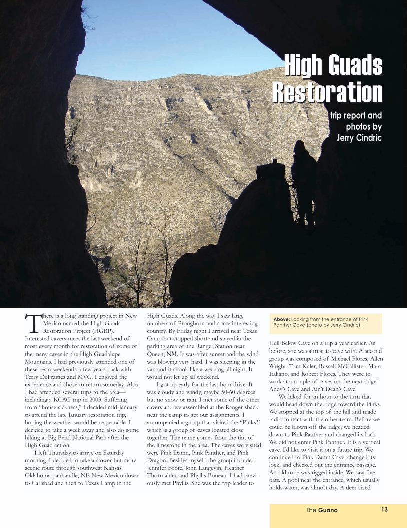
There is a long standing project in NewMexico named the High GuadsRestoration Project (HGRP).
Interested cavers meet the last weekend ofmost every month for restoration of some ofthe many caves in the High GuadalupeMountains. I had previously attended one ofthese resto weekends a few years back withTerry DeFraities and MVG. I enjoyed theexperience and chose to return someday. AlsoI had attended several trips to the area�including a KCAG trip in 2003. Sufferingfrom �house sickness,� I decided mid-Januaryto attend the late January restoration trip,hoping the weather would be respectable. Idecided to take a week away and also do somehiking at Big Bend National Park after theHigh Guad action.
I left Thursday to arrive on Saturdaymorning. I decided to take a slower but morescenic route through southwest Kansas,Oklahoma panhandle, NE New Mexico downto Carlsbad and then to Texas Camp in the
High Guads. Along the way I saw largenumbers of Pronghorn and some interestingcountry. By Friday night I arrived near TexasCamp but stopped short and stayed in theparking area of the Ranger Station nearQueen, NM. It was after sunset and the windwas blowing very hard. I was sleeping in thevan and it shook like a wet dog all night. Itwould not let up all weekend.
I got up early for the last hour drive. Itwas cloudy and windy, maybe 50-60 degreesbut no snow or rain. I met some of the othercavers and we assembled at the Ranger shacknear the camp to get our assignments. Iaccompanied a group that visited the �Pinks,�which is a group of caves located closetogether. The name comes from the tint ofthe limestone in the area. The caves we visitedwere Pink Damn, Pink Panther, and PinkDragon. Besides myself, the group includedJennifer Foote, John Langevin, HeatherThormahlen and Phyllis Boneau. I had previ-ously met Phyllis. She was the trip leader to
Hell Below Cave on a trip a year earlier. Asbefore, she was a treat to cave with. A secondgroup was composed of Michael Flores, AllenWright, Tom Kaler, Russell McCallister, MarcItaliano, and Robert Flores. They were towork at a couple of caves on the next ridge:Andy�s Cave and Ain�t Dean�s Cave.
We hiked for an hour to the turn thatwould head down the ridge toward the Pinks.We stopped at the top of the hill and maderadio contact with the other team. Before wecould be blown off the ridge, we headeddown to Pink Panther and changed its lock.We did not enter Pink Panther. It is a verticalcave. I�d like to visit it on a future trip. Wecontinued to Pink Damn Cave, changed itslock, and checked out the entrance passage.An old rope was rigged inside. We saw fivebats. A pool near the entrance, which usuallyholds water, was almost dry. A deer-sized
trip report andphotos by
Jerry Cindric
Above: Looking from the entrance of PinkPanther Cave (photo by Jerry Cindric).
High GuadsRestoration
High GuadsRestoration
The Guano14
skeleton was tucked in a niche in the wall.There was also some old-looking charcoal inthe entrance outside the gate.
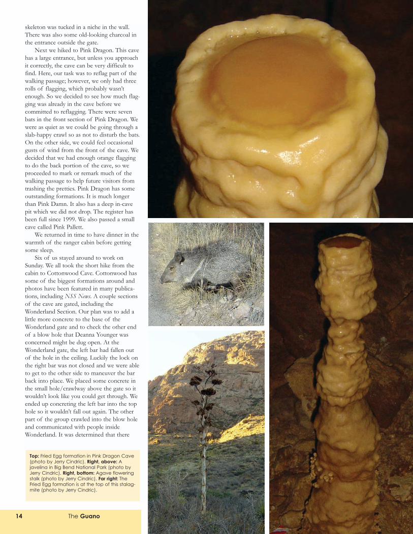
Next we hiked to Pink Dragon. This cavehas a large entrance, but unless you approachit correctly, the cave can be very difficult tofind. Here, our task was to reflag part of thewalking passage; however, we only had threerolls of flagging, which probably wasn�tenough. So we decided to see how much flag-ging was already in the cave before wecommitted to reflagging. There were sevenbats in the front section of Pink Dragon. Wewere as quiet as we could be going through aslab-happy crawl so as not to disturb the bats.On the other side, we could feel occasionalgusts of wind from the front of the cave. Wedecided that we had enough orange flaggingto do the back portion of the cave, so weproceeded to mark or remark much of thewalking passage to help future visitors fromtrashing the pretties. Pink Dragon has someoutstanding formations. It is much longerthan Pink Damn. It also has a deep in-cavepit which we did not drop. The register hasbeen full since 1999. We also passed a smallcave called Pink Pallett.
We returned in time to have dinner in thewarmth of the ranger cabin before gettingsome sleep.
Six of us stayed around to work onSunday. We all took the short hike from thecabin to Cottonwood Cave. Cottonwood hassome of the biggest formations around andphotos have been featured in many publica-tions, including NSS News. A couple sectionsof the cave are gated, including theWonderland Section. Our plan was to add alittle more concrete to the base of theWonderland gate and to check the other endof a blow hole that Deanna Younger wasconcerned might be dug open. At theWonderland gate, the left bar had fallen outof the hole in the ceiling. Luckily the lock onthe right bar was not closed and we were ableto get to the other side to maneuver the barback into place. We placed some concrete inthe small hole/crawlway above the gate so itwouldn�t look like you could get through. Weended up concreting the left bar into the tophole so it wouldn�t fall out again. The otherpart of the group crawled into the blow holeand communicated with people insideWonderland. It was determined that there
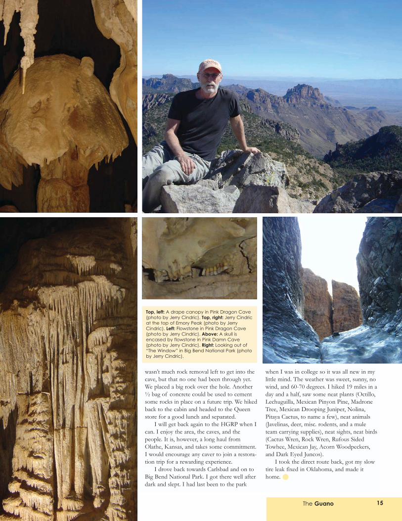
Top: Fried Egg formation in Pink Dragon Cave(photo by Jerry Cindric). Right, above: Ajavelina in Big Bend National Park (photo byJerry Cindric). Right, bottom: Agave floweringstalk (photo by Jerry Cindric). Far right: TheFried Egg formation is at the top of this stalag-mite (photo by Jerry Cindric).
The Guano 15
wasn�t much rock removal left to get into thecave, but that no one had been through yet.We placed a big rock over the hole. Another½ bag of concrete could be used to cementsome rocks in place on a future trip. We hikedback to the cabin and headed to the Queenstore for a good lunch and separated.
I will get back again to the HGRP when Ican. I enjoy the area, the caves, and thepeople. It is, however, a long haul fromOlathe, Kansas, and takes some commitment.I would encourage any caver to join a restora-tion trip for a rewarding experience.
I drove back towards Carlsbad and on toBig Bend National Park. I got there well afterdark and slept. I had last been to the park
when I was in college so it was all new in mylittle mind. The weather was sweet, sunny, nowind, and 60-70 degrees. I hiked 19 miles in aday and a half, saw some neat plants (Octillo,Lechuguilla, Mexican Pinyon Pine, MadroneTree, Mexican Drooping Juniper, Nolina,Pitaya Cactus, to name a few), neat animals(Javelinas, deer, misc. rodents, and a muleteam carrying supplies), neat sights, neat birds(Cactus Wren, Rock Wren, Rufous SidedTowhee, Mexican Jay, Acorn Woodpeckers,and Dark Eyed Juncos).
I took the direct route back, got my slowtire leak fixed in Oklahoma, and made ithome.
Top, left: A drape canopy in Pink Dragon Cave(photo by Jerry Cindric). Top, right: Jerry Cindricat the top of Emory Peak (photo by JerryCindric). Left: Flowstone in Pink Dragon Cave(photo by Jerry Cindric). Above: A skull isencased by flowstone in Pink Damn Cave(photo by Jerry Cindric). Right: Looking out of�The Window� in Big Bend National Park (photoby Jerry Cindric).
Since retiring in late 2005, I had somefrequent flyer points burning a holein my pocket. I worked hard on my
wife for a family Caribbean vacation, butshe was not excited by the idea. So Idecided to do something on my own. Whynot combine caving with some island fun? Ichecked the places in the Caribbean whereUS Air travels to see if they containedcaves. One destination was Antigua, but theisland seemed pretty void of caves. Ichecked Antigua�s sister island Barbuda andgot a few cave hits. I learned that Barbudahas less than 2,000 inhabitants and is lightlyvisited. At this point, how was I going toworm my way into some caving action? Isent an e-mail message to Ray Keeler, anArizona caver who worked in KC a fewyears back. Did he know a caver who
frequents Caribbean caves? He led me toDr. Donald McFarlane. Don is fromCalifornia and is the Chair of the NSSResearch Advisory Committee. Don haddone a bit of caving in both Antigua andBarbuda and had a good contact. Onesmall issue: his contact had recently died.Don had another name for me; however,he did not know much about the fellow.After some persistence, I got a phonenumber for a contact on Barbuda. E-mailsfollowed and I had myself a trip.
Saturday
I arrive in Antigua on Saturday, April 29,having lost a piece of luggage that containsmost of my caving supplies. From Antigua,I catch a short flight to Barbuda, landing atdusk just south of the village of
Codrington. My contact, John ______ hasarranged a taxi to meet me. It is a two-minute ride to the guesthouse. Driving ison the left, steering wheel on the right,British style. My guesthouse is above whatwould best be described as a drugstore runby the owner, Mr. Hartford John, who livesbehind the store and under the guesthouse.The store and guesthouse are a block fromvillage center. I settle in with a little TV andNBA basketball. My contact stops by for adiscussion. I tell him the bad newsconcerning the lost luggage. He informsme that because it is a holiday weekend Iwill need to wait some time to rent avehicle. John ______ is very amiable. We
The Guano16
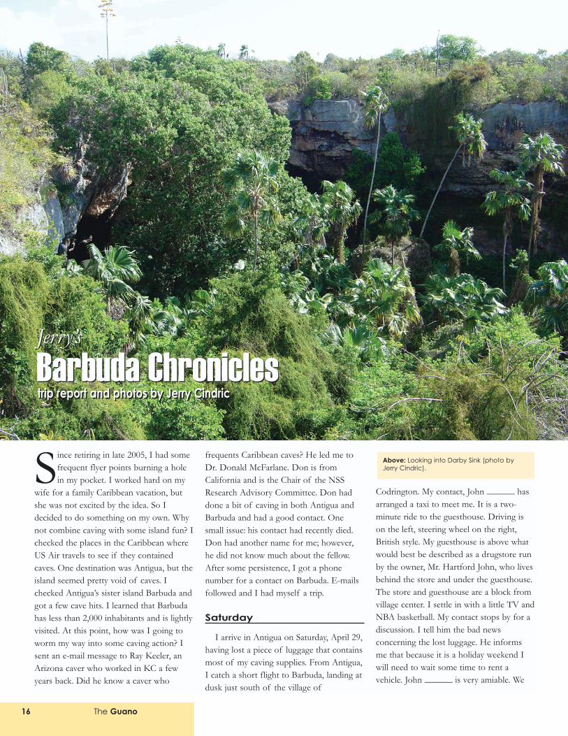
Above: Looking into Darby Sink (photo byJerry Cindric).
Jerry�s
Barbuda ChroniclesJerry�s
Barbuda Chroniclestrip report and photos by Jerry Cindrictrip report and photos by Jerry Cindric
The Guano 17
discuss my activities for the week. I ammissing my binoculars, GPS, snorkelingstuff, and much more. If the bag is notfound in a day or two, it will really dampenmy visit. I need to make the best of it. Ipull out my 1:10,000 Barbuda topographicalmaps. John discusses the locations of thecaves and the sinks. I had entered the coor-dinates of about 45 depressions/sinks inmy GPS unit.
We will go to Darby Sink Cave, which isconnected to a very large sink east ofCodrington; Dark Cave, which containsblind cave shrimp; and another cave nearDark Cave of special interest. John says hehas not been to this last cave in severalyears. The entrance is a small crack in asinkhole. He describes entering the caveand feeling much heat inside. He went intoa large room with a huge bat population,which he said provided the excessive heat(wow!). I hope we can find it (and histo-plasmosis isn�t a problem). We walk to thelocal grocery. There are interesting things atthe market: banana milk, local bananas, andfruit that I could not pronounce. I get afew things to eat, and we say goodnight.The bed is hard and the fan noisy, but Ieasily fall asleep.
Sunday
I am up at about 7:00 A.M. and my backis slightly sore. I finish reading Into the Wildon the porch, where it�s shady and there is awarm, light breeze. An Anglican church isholding service nearby. I can hear thesinging and the preaching. I see little birds Idon�t recognize in the trees. I take a walk tothe small lagoon pier where I will later headto the Frigate Bird Sanctuary. The peopleare polite and speak with a great accent. Ihave a bit of a problem understandingsome of them. The houses are small,mostly well-kept with tin roofs. Because itis Sunday morning, I hear many religiousshows from the radios. Chickens, lizards,and goats have a free reign of the village.There are only a few cars and a few asphaltstreets. Other roads are crushed stone.Bicycles far outnumber cars. The water inthe lagoon is a brilliant blue. The localscollect rain water in 200 gallon tanks forwashing clothes and whatever else. I havenot seen an open restaurant, so I eat abanana and some sardines for breakfast anddrink banana milk (great). (I also have aRed Bull to help kill my caffeine headache.)I had foresight to pack my alcohol stove,with coffee bags, oatmeal, and KASHI bars.
Unfortunately, it is all in the missing bag!Can I cave in sandals? John is supposed tolend me a cell phone. I can buy a phonecard to call home and the airline. There isno hot water in the guesthouse, but it is notneeded. The cold water is not cold. It�s alsoquite salty tasting. I remember Johndiscussing the island terrain. He said it�spretty flat (the highest point is about 130feet above sea level). This makes it easy toget lost while walking. Without the GPS, Iwill need to be careful. I had been warnedby Don McFarlane that a hiker got lost anddied on the island.
Monday
No luggage and no vehicle yet. I�ll needto make more phone calls. I walk to theCodrington pier in hope that I can get aride to Frigate Bird Sanctuary. I have a nicetalk with a few locals at the pier. Some ofthe people are pretty easy to understandwhile others are almost impossible. I findout there was a large hurricane in 1995.Some of the decrepit buildings in thevillage are due to this hurricane. There islots of bantering about fish, lobster, turtles,and the sea.
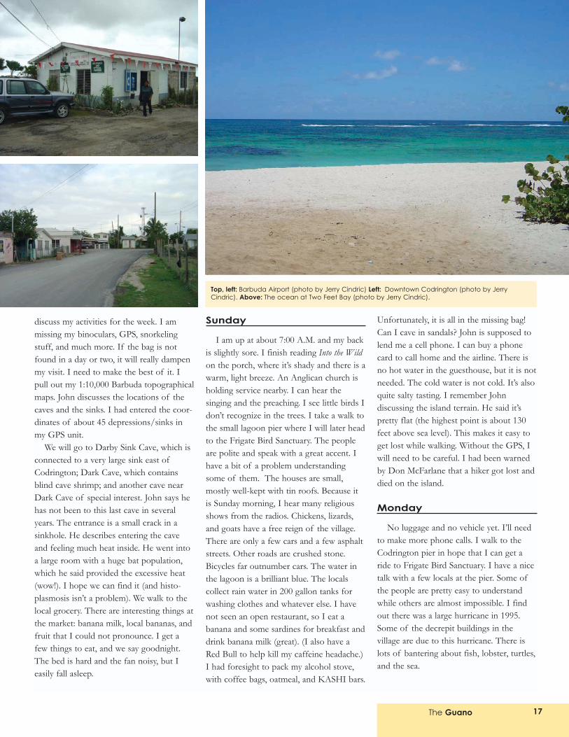
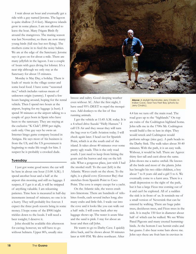
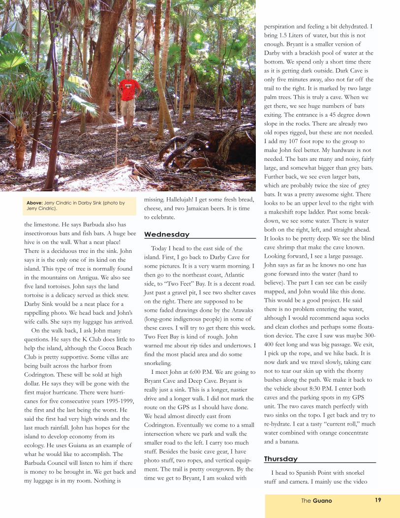
Top, left: Barbuda Airport (photo by Jerry Cindric) Left: Downtown Codrington (photo by JerryCindric). Above: The ocean at Two Feet Bay (photo by Jerry Cindric).
The Guano18
I wait about an hour and eventually get aride with a guy named Jerome. The lagoonis quite shallow (3-4 feet). Mangrove islandsgrow in some places. I am not allowed toleave the boat. Many Frigate Birds flyaround the mangroves. The mating seasonwas last November, so there are now manyyoung birds (full size but not flying). Themothers come in to feed the noisy babies.We are at the edge of the Sanctuary. Jeromesays it goes on for about a mile. There aremany jellyfish in the lagoon. I see a coupleof boats with guys diving for lobster. It�s aneat trip although we only stay at theSanctuary for about 15 minutes.
Monday is May Day, a holiday. There isloads of music in the village center andsome local food. I have some �seasonedrice,� which includes various meats ofunknown origin (yummy). I spend a fewhours hanging around, hoping for the rentalvehicle. Then I spend two hours at theairport, hoping for my luggage (a bust). Ispend 30 minutes at the airport talking to acouple of guys born in Spain who havebeen to the sanctuary. They are staying atthe exclusive �K Club�; $900 per night,cash only. One guy says he owns anInternet bingo game company located inAntigua. He says most of his business isfrom the US, and the US government isbeginning to make life tough for him. Isuspect he is probably a crooked dude.
Tuesday
I just got some good news: the car willbe here in about one hour (11:00 A.M.). Ispend another hour and a half at theairport this morning and still no luggage. Isuspect, if I get it at all, it will be strippedof anything valuable. I am relearningpatience. Time here is measured in half-dayincrements instead of minutes; no one is ina hurry. They will probably live forever. Iexpect the three posh resorts bring in somemoney. I hope some of the $900/nighttrickles down to the locals. I will need abeer tonight; I deserve it.
John should be available this afternoonfor caving; however, we will have to gowithout helmets. Upper 80�s, usually nice
breeze and sultry. Good sleeping weathereven without AC. After the first night, Ihave used 95% DEET to repel the mosqui-toes. Add donkeys to the list of freerunning animals.
I get the vehicle at 11:45 A.M. today. It isa 4-wheel drive Suzuki �Helly Hansen.� Icall US Air and they swear they will turnthe bag over to Carib Aviation today. I willcheck again later. I head out for SpanishPoint, which is at the south end of theisland. It takes about 40 minutes over somepretty ugly roads. This is the only roadsouth. I just need to keep from hitting thegoats and the burros and stay on the leftside. What a gorgeous place, just wish I hadthe snorkel stuff. To the east (left) is theAtlantic. Waves crash on the shore. To theright, is a placid cove (Grovenor Bay) thatstretches from Spanish Point to CocoPoint. The cove is empty except for a yacht.
On the Atlantic side, the waves crashinto limestone. There are hundreds of trilo-bites fossils, each several inches long; alsomany crabs and little fish. I wade out intothe cove and it looks like you can walk outa half mile. I will come back after myluggage shows up. The water is azure blueand the sand is pink. I stay for about anhour and then call John.
He wants to go to Darby Cave. I quicklydrive back, and he shows about 30 minuteslater at 4:00 P.M. We drive northeast. After
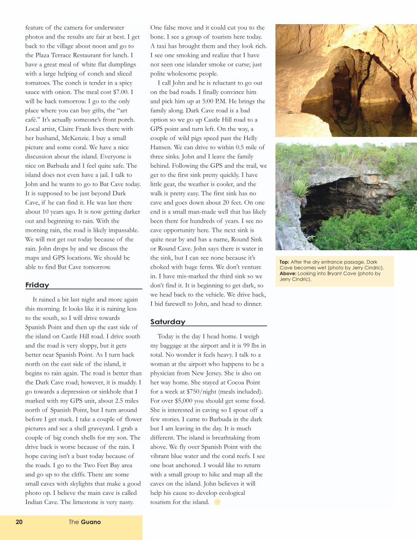
4.4 km we turn off the main road. Theroad goes up to the �highlands.� On topare ruins of the Codrington highland home.John tells me in the 1700s Mr. Codringtonwould build a fire to lure in ships. Theywould wreck and Codrington wouldperform salvage (nice guy). A path heads tothe Darby Sink. The walk takes about 30-40minutes. With the path, it is an easy walk.Without, it would be hell. There are Agavesthirty feet tall and cacti about the same.John shows me a native orchid. He knowsall the birds and most of the plants. Johnhas brought his two older children, a boyabout 7 to 8 years old and a girl 5 to 6. Weeventually come to a karst area. There is asmall depression to the right of the path,but it has a large Ficus tree coming out ofit and can�t be explored. All of a suddenthe sink is in front of us. It reminds me ofa small version of Neversink that can beentered by walking. There are huge palmtrees, deciduous trees, and Ficus trees in thesink. It is maybe 150 feet in diameter abouthalf of which can be walked. We see WhitePated Pigeons and many crested humming-birds. At the bottom I see hermit crabs andbat guano. I also hear some bats above me.John says these are fruit bats in crevices in
Above: A skylight illuminates Jerry Cindric inIndian Cave, near Two Feet Bay (photo byJerry Cindric).
The Guano 19
the limestone. He says Barbuda also hasinsectivorous bats and fish bats. A huge beehive is on the wall. What a neat place!There is a deciduous tree in the sink. Johnsays it is the only one of its kind on theisland. This type of tree is normally foundin the mountains on Antigua. We also seefive land tortoises. John says the landtortoise is a delicacy served as thick stew.Darby Sink would be a neat place for arappelling photo. We head back and John�swife calls. She says my luggage has arrived.
On the walk back, I ask John manyquestions. He says the K Club does little tohelp the island, although the Cocoa BeachClub is pretty supportive. Some villas arebeing built across the harbor fromCodrington. These will be sold at highdollar. He says they will be gone with thefirst major hurricane. There were hurri-canes for five consecutive years 1995-1999,the first and the last being the worst. Hesaid the first had very high winds and thelast much rainfall. John has hopes for theisland to develop economy from itsecology. He uses Guiana as an example ofwhat he would like to accomplish. TheBarbuda Council will listen to him if thereis money to be brought in. We get back andmy luggage is in my room. Nothing is
missing. Hallelujah! I get some fresh bread,cheese, and two Jamaican beers. It is timeto celebrate.
Wednesday
Today I head to the east side of theisland. First, I go back to Darby Cave forsome pictures. It is a very warm morning. Ithen go to the northeast coast, Atlanticside, to �Two Feet� Bay. It is a decent road.Just past a gravel pit, I see two shelter caveson the right. There are supposed to besome faded drawings done by the Arawaks(long-gone indigenous people) in some ofthese caves. I will try to get there this week.Two Feet Bay is kind of rough. Johnwarned me about rip tides and undertows. Ifind the most placid area and do somesnorkeling.
I meet John at 6:00 P.M. We are going toBryant Cave and Deep Cave. Bryant isreally just a sink. This is a longer, nastierdrive and a longer walk. I did not mark theroute on the GPS as I should have done.We head almost directly east fromCodrington. Eventually we come to a smallintersection where we park and walk thesmaller road to the left. I carry too muchstuff. Besides the basic cave gear, I havephoto stuff, two ropes, and vertical equip-ment. The trail is pretty overgrown. By thetime we get to Bryant, I am soaked with
perspiration and feeling a bit dehydrated. Ibring 1.5 Liters of water, but this is notenough. Bryant is a smaller version ofDarby with a brackish pool of water at thebottom. We spend only a short time thereas it is getting dark outside. Dark Cave isonly five minutes away, also not far off thetrail to the right. It is marked by two largepalm trees. This is truly a cave. When weget there, we see huge numbers of batsexiting. The entrance is a 45 degree downslope in the rocks. There are already twoold ropes rigged, but these are not needed.I add my 107 foot rope to the group tomake John feel better. My hardware is notneeded. The bats are many and noisy, fairlylarge, and somewhat bigger than grey bats.Further back, we see even larger bats,which are probably twice the size of greybats. It was a pretty awesome sight. Therelooks to be an upper level to the right witha makeshift rope ladder. Past some break-down, we see some water. There is waterboth on the right, left, and straight ahead.It looks to be pretty deep. We see the blindcave shrimp that make the cave known.Looking forward, I see a large passage.John says as far as he knows no one hasgone forward into the water (hard tobelieve). The part I can see can be easilymapped, and John would like this done.This would be a good project. He saidthere is no problem entering the water,although I would recommend aqua socksand clean clothes and perhaps some floata-tion device. The cave I saw was maybe 300-400 feet long and was big passage. We exit,I pick up the rope, and we hike back. It isnow dark and we travel slowly, taking carenot to tear our skin up with the thornybushes along the path. We make it back tothe vehicle about 8:30 P.M. I enter bothcaves and the parking spots in my GPSunit. The two caves match perfectly withtwo sinks on the topo. I get back and try tore-hydrate. I eat a tasty �current roll,� muchwater combined with orange concentrateand a banana.
Thursday
I head to Spanish Point with snorkelstuff and camera. I mainly use the video
Above: Jerry Cindric in Darby Sink (photo byJerry Cindric).
The Guano20
feature of the camera for underwaterphotos and the results are fair at best. I getback to the village about noon and go tothe Plaza Terrace Restaurant for lunch. Ihave a great meal of white flat dumplingswith a large helping of conch and slicedtomatoes. The conch is tender in a spicysauce with onion. The meal cost $7.00. Iwill be back tomorrow. I go to the onlyplace where you can buy gifts, the �artcafé.� It�s actually someone�s front porch.Local artist, Claire Frank lives there withher husband, McKenzie. I buy a smallpicture and some coral. We have a nicediscussion about the island. Everyone isnice on Barbuda and I feel quite safe. Theisland does not even have a jail. I talk toJohn and he wants to go to Bat Cave today.It is supposed to be just beyond DarkCave, if he can find it. He was last thereabout 10 years ago. It is now getting darkerout and beginning to rain. With themorning rain, the road is likely impassable.We will not get out today because of therain. John drops by and we discuss themaps and GPS locations. We should beable to find Bat Cave tomorrow.
Friday
It rained a bit last night and more againthis morning. It looks like it is raining lessto the south, so I will drive towardsSpanish Point and then up the east side ofthe island on Castle Hill road. I drive southand the road is very sloppy, but it getsbetter near Spanish Point. As I turn backnorth on the east side of the island, itbegins to rain again. The road is better thanthe Dark Cave road; however, it is muddy. Igo towards a depression or sinkhole that Imarked with my GPS unit, about 2.5 milesnorth of Spanish Point, but I turn aroundbefore I get stuck. I take a couple of flowerpictures and see a shell graveyard. I grab acouple of big conch shells for my son. Thedrive back is worse because of the rain. Ihope caving isn�t a bust today because ofthe roads. I go to the Two Feet Bay areaand go up to the cliffs. There are somesmall caves with skylights that make a goodphoto op. I believe the main cave is calledIndian Cave. The limestone is very nasty.
One false move and it could cut you to thebone. I see a group of tourists here today.A taxi has brought them and they look rich.I see one smoking and realize that I havenot seen one islander smoke or curse; justpolite wholesome people.
I call John and he is reluctant to go outon the bad roads. I finally convince himand pick him up at 5:00 P.M. He brings thefamily along. Dark Cave road is a badoption so we go up Castle Hill road to aGPS point and turn left. On the way, acouple of wild pigs speed past the HellyHansen. We can drive to within 0.5 mile ofthree sinks. John and I leave the familybehind. Following the GPS and the trail, weget to the first sink pretty quickly. I havelittle gear, the weather is cooler, and thewalk is pretty easy. The first sink has nocave and goes down about 20 feet. On oneend is a small man-made well that has likelybeen there for hundreds of years. I see nocave opportunity here. The next sink isquite near by and has a name, Round Sinkor Round Cave. John says there is water inthe sink, but I can see none because it�schoked with huge ferns. We don�t venturein. I have mis-marked the third sink so wedon�t find it. It is beginning to get dark, sowe head back to the vehicle. We drive back,I bid farewell to John, and head to dinner.
Saturday
Today is the day I head home. I weighmy baggage at the airport and it is 99 lbs intotal. No wonder it feels heavy. I talk to awoman at the airport who happens to be aphysician from New Jersey. She is also onher way home. She stayed at Cocoa Pointfor a week at $750/night (meals included).For over $5,000 you should get some food.She is interested in caving so I spout off afew stories. I came to Barbuda in the darkbut I am leaving in the day. It is muchdifferent. The island is breathtaking fromabove. We fly over Spanish Point with thevibrant blue water and the coral reefs. I seeone boat anchored. I would like to returnwith a small group to hike and map all thecaves on the island. John believes it willhelp his cause to develop ecologicaltourism for the island.
Top: After the dry entrance passage, DarkCave becomes wet (photo by Jerry Cindric).Above: Looking into Bryant Cave (photo byJerry Cindric).
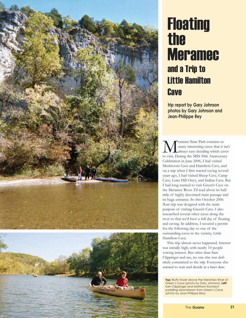
Meramec State Park contains somany interesting caves that it isn�talways easy deciding which caves
to visit. During the MSS 50th AnniversaryCelebration in June 2006, I had visitedMushroom Cave and Hamilton Cave, andon a trip when I first started caving severalyears ago, I had visited Sheep Cave, CampCave, Lone Hill Onyx, and Indian Cave. ButI had long wanted to visit Green�s Cave onthe Meramec River. I�d read about its halfmile of highly decorated main passage andits huge entrance. So this October 2006float trip was designed with the mainpurpose of visiting Green�s Cave. I alsoresearched several other caves along theriver so that we�d have a full day of floatingand caving. In addition, I secured a permitfor the following day to one of theoutstanding caves in the vicinity, LittleHamilton Cave.
This trip almost never happened. Interestwas initially high, with nearly 10 peoplevoicing interest. But other than SamClippinger and me, no one else was defi-nitely committed to the trip. Everyone elsewanted to wait and decide at a later date.
The Guano 21
Top: Bluffs tower above the Meramec River atGreen�s Cave (photo by Gary Johnson). Left:Sam Clippinger and Matthew Krumlaufpaddling downstream from Green�s Cave(photo by Jean-Philippe Rey).
FloatingtheMeramecand a Trip to Little HamiltonCavetrip report by Gary Johnsonphotos by Gary Johnson andJean-Philippe Rey
The Guano 23
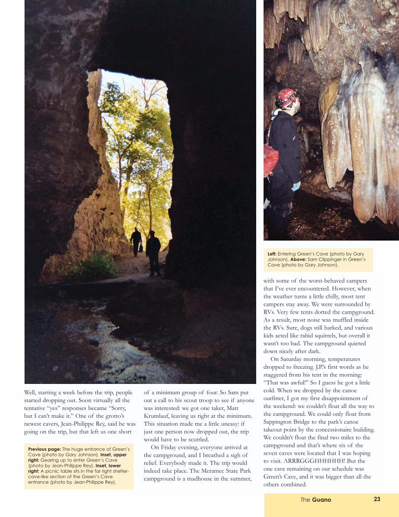
Well, starting a week before the trip, peoplestarted dropping out. Soon virtually all thetentative �yes� responses became �Sorry,but I can�t make it.� One of the grotto�snewest cavers, Jean-Philippe Rey, said he wasgoing on the trip, but that left us one short
of a minimum group of four. So Sam putout a call to his scout troop to see if anyonewas interested: we got one taker, MattKrumlauf, leaving us right at the minimum.This situation made me a little uneasy: ifjust one person now dropped out, the tripwould have to be scuttled.
On Friday evening, everyone arrived atthe campground, and I breathed a sigh ofrelief. Everybody made it. The trip wouldindeed take place. The Meramec State Parkcampground is a madhouse in the summer,
with some of the worst-behaved campersthat I�ve ever encountered. However, whenthe weather turns a little chilly, most tentcampers stay away. We were surrounded byRVs. Very few tents dotted the campground.As a result, most noise was muffled insidethe RVs. Sure, dogs still barked, and variouskids acted like rabid squirrels, but overall itwasn�t too bad. The campground quieteddown nicely after dark.
On Saturday morning, temperaturesdropped to freezing. J.P.�s first words as hestaggered from his tent in the morning:�That was awful!� So I guess he got a littlecold. When we dropped by the canoeoutfitter, I got my first disappointment ofthe weekend: we couldn�t float all the way tothe campground. We could only float fromSappington Bridge to the park�s canoetakeout point by the concessionaire building.We couldn�t float the final two miles to thecampground and that�s where six of theseven caves were located that I was hopingto visit. ARRRGGGHHHHHH! But theone cave remaining on our schedule wasGreen�s Cave, and it was bigger than all theothers combined.
Left: Entering Green�s Cave (photo by GaryJohnson). Above: Sam Clippinger in Green�sCave (photo by Gary Johnson).
Previous page: The huge entrance of Green�sCave (photo by Gary Johnson). Inset, upperright: Gearing up to enter Green�s Cave(photo by Jean-Philippe Rey). Inset, lowerright: A picnic table sits in the far right shelter-cave-like section of the Green�s Caveentrance (photo by Jean-Philippe Rey).
The Guano24
The guy who would be driving us to theput-in point said we could visit the othercaves by hiking upstream from the camp-ground. We�d have to wade across the river.I knew the caves in questions were all rela-tively short, with several in the 50-100 footlong range. If we could�ve floated right totheir entrances � maybe they would�vebeen worth visiting. But if we had to bush-whack and wade for these little caves �well, I suspected it wouldn�t be time wellspent.
Anyway, we set off for SappingtonBridge in the shuttle bus, with the driverproviding non-stop narration. Sam and J.P.seemed to enjoy the narration, which largelyconsisted of the driver playing the role ofSanta Claus (and yes, he did sort of looklike Santa Claus), but after 15 minutes ofthis, I was about ready to scream. However,the driver did provide one tasty bit of trivia:along Hwy. D, you�ll see some huge homes,with price tags of over $1,000,000, andthese homes are arranged to have a great
Top, left: Jean-Philippe Rey and MatthewKrumlauf with a terraced stalagmite (photo byGary Johnson). Top, right: Flowstone coats thewalls in Green�s Cave (photo by GaryJohnson). Left: Sam Clippinger in Green�sCave (photo by Gary Johnson).
The Guano 25
view over � a lake that never happened!Yes, the homes were built in anticipation ofMeramec Dam being built near HamiltonHollow, but of course, opposition arose andthe project was eventually abandoned. Sonow the stately homes look out over �cattle pasture!
Sappington Bridge Access has a fair-sizedparking lot (that might hold 20 cars) and along concrete ramp to the river. I suspectthings get sort of crazy in the summer,when several hundred people float theMeramec each weekend day, but on thisSaturday morning, there were just fivecanoes sitting on the bank. And as wefloated down the river, we didn�t encountermany other canoes, maybe a dozen. So itwas a fairly pleasant float.
The Meramec is an easy river to float,with no rapids or constrictions or largeobstructions. Frequently, J.P. and I ended upchoosing the tricky routes on purposebecause the wide, easy alternatives lookedplain boring. The river doesn�t help youmuch with your float speed. It frequentlylooks like a pond, so any downstreamvelocity you acquire is strictly based onpaddling. Having said this, though, therewere a few places where snags presentedsome minor problems, and overall, I sawmore snags on the Meramec than on theEleven Point, where the water runs wide,deep, and fast.
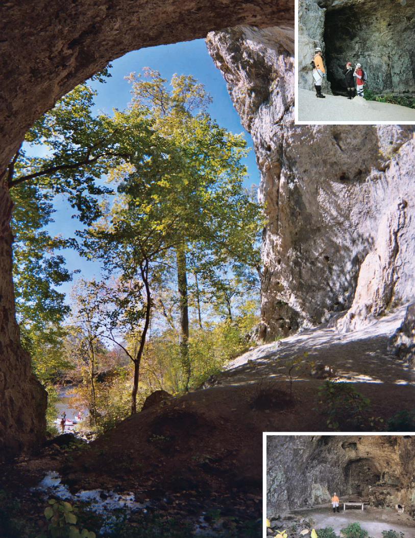
Green�s Cave sits about two miles downriver from the access point. I suppose aninattentive paddler could possibly float rightpast the cave without realizing it�s there.While the entrance dimensions at thedripline are approximately 100 wide by 90feet high, a line of trees does a middling jobof obscuring the entrance. As we floateddown the river, I noticed a light shadowbehind the trees, on the face of the bluff,forming a large arc in the background. MyGPS unit said we were within a couplehundred feet of the cave, so we paddled forthe river�s east bank and pulled our canoesout of the water.
The wide entrance of Green�s Caveresembles a shelter cave. The cave streambisects the entrance area. On the right, theremains of a concrete picnic table sits in adepression in the bluff. On the left, theentrance area looks like an undercut bluff.Sunlight hit this area full force.
Unlike, Jam Up Cave on the Jacks ForkRiver, where the huge entrance dimensionsare maintained for about 300 feet back intothe ridge, here at Green�s Cave, the main
passage immediately narrows beyond theshelter-cave-like entrance area to about 35feet high by 30 feet wide. The passage main-tains these dimensions for only about 100feet before narrowing again. At a small two-foot-high waterfall, the passage drops toabout 20 feet high by 8 feet wide. These arethe dimensions that the cave maintains formuch of the remainder of its length, untilthe final 300 feet when the passage finallypinches.
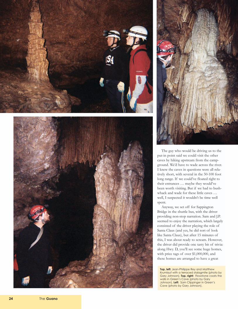
Immediately beyond the little waterfallnear the entrance, the passage is highlydecorated with white flowstone that coatsthe walls. This flowstone is dry and deterio-rating, but it�s impressive nonetheless. Fromhere on, you�re frequently sloshing throughwater, but you can remain standing. This iseasy walking passage, and I�m sure it getsvisited many times every day in the summerby flashlight cavers.
This is a remarkable cave. Once you�re atleast 200 feet into the cave, the formationsare moist and shiny. We kept pulling out ourcameras every few feet. I was only packing aone-time-use camera, which has a flash thatis only good for about 15 feet. But that wasjust about the right flash-to-subject distance.
You don�t enter any large rooms. Thepassage is sinuous, curving left, then right(repeat numerous times). Long sight linesare rare. So there is always limited distanceto work with when taking photographs.
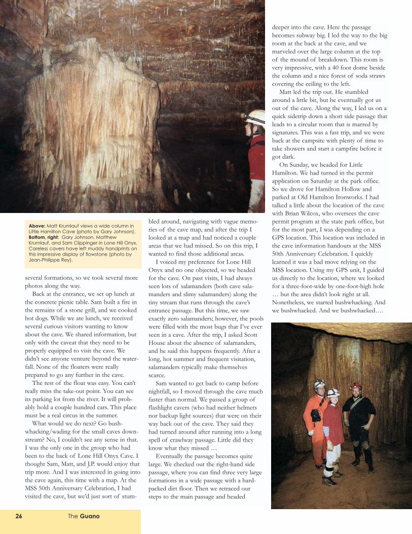
The main passage is typically coated onboth sides with flowstone. Sometimesmodest columns form on ledges. Sometimeslarge columns several feet thick stand in thepassage. I suspect many of the finer, more-delicate formations have been vandalized.For example, you typically just see soda-straw stubs. But there are plenty of impres-sive formations still remaining in this cave.
After a half mile of walking passage, theceiling finally descended. We crawled onhands and knees for a while. I pulled out thecave map and guessed we were near the end,but I wasn�t sure because I hadn�t reallylooked at the map until this point. Sam tookthe duties of belly crawling forward. Hecrawled about 50 feet and encountered alittle place where he could sit up. From here,he said the remaining passage looked small.His findings agreed with what the mapshowed for the final few feet of passage. Icalled him back. The walk back outpresented us with a new perspective on
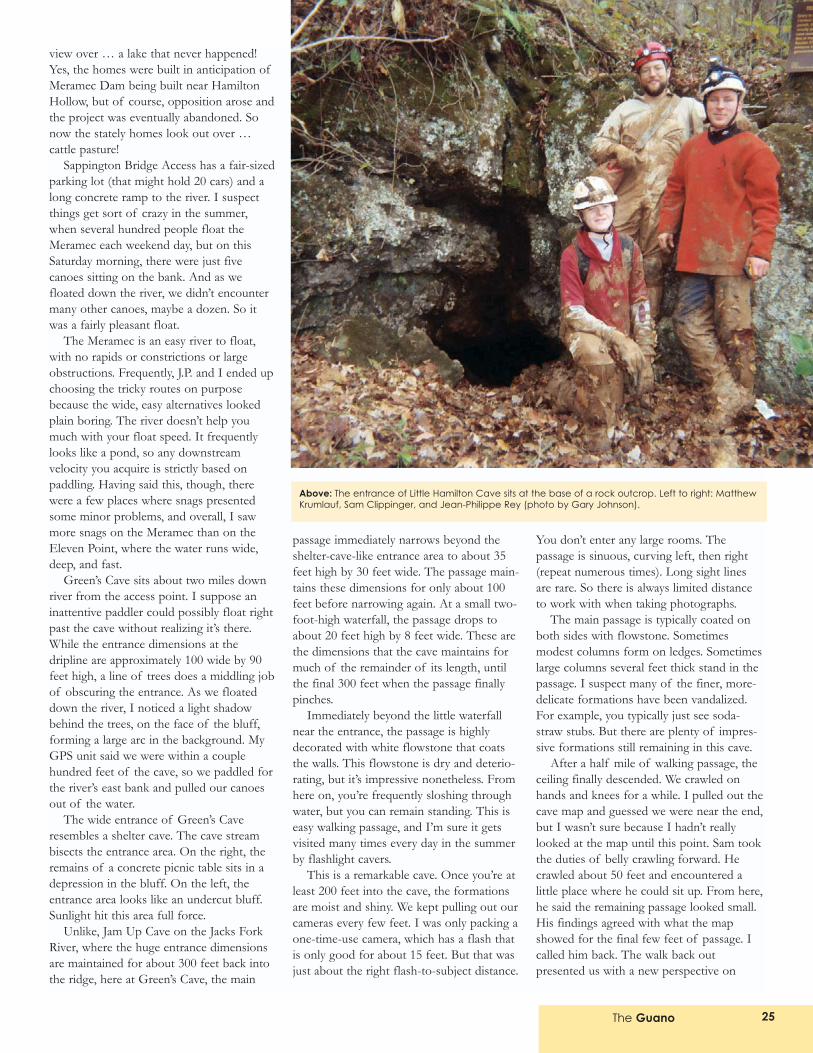
Above: The entrance of Little Hamilton Cave sits at the base of a rock outcrop. Left to right: MatthewKrumlauf, Sam Clippinger, and Jean-Philippe Rey (photo by Gary Johnson).
The Guano26
several formations, so we took several morephotos along the way.
Back at the entrance, we set up lunch atthe concrete picnic table. Sam built a fire inthe remains of a stone grill, and we cookedhot dogs. While we ate lunch, we receivedseveral curious visitors wanting to knowabout the cave. We shared information, butonly with the caveat that they need to beproperly equipped to visit the cave. Wedidn�t see anyone venture beyond the water-fall. None of the floaters were reallyprepared to go any further in the cave.
The rest of the float was easy. You can�treally miss the take-out point. You can seeits parking lot from the river. It will prob-ably hold a couple hundred cars. This placemust be a real circus in the summer.
What would we do next? Go bush-whacking/wading for the small caves down-stream? No, I couldn�t see any sense in that.I was the only one in the group who hadbeen to the back of Lone Hill Onyx Cave. Ithought Sam, Matt, and J.P. would enjoy thattrip more. And I was interested in going intothe cave again, this time with a map. At theMSS 50th Anniversary Celebration, I hadvisited the cave, but we�d just sort of stum-
bled around, navigating with vague memo-ries of the cave map, and after the trip Ilooked at a map and had noticed a coupleareas that we had missed. So on this trip, Iwanted to find those additional areas.
I voiced my preference for Lone HillOnyx and no one objected, so we headedfor the cave. On past visits, I had alwaysseen lots of salamanders (both cave sala-manders and slimy salamanders) along thetiny stream that runs through the cave�sentrance passage. But this time, we sawexactly zero salamanders; however, the poolswere filled with the most bugs that I�ve everseen in a cave. After the trip, I asked ScottHouse about the absence of salamanders,and he said this happens frequently. After along, hot summer and frequent visitation,salamanders typically make themselvesscarce.
Sam wanted to get back to camp beforenightfall, so I moved through the cave muchfaster than normal. We passed a group offlashlight cavers (who had neither helmetsnor backup light sources) that were on theirway back out of the cave. They said theyhad turned around after running into a longspell of crawlway passage. Little did theyknow what they missed �
Eventually the passage becomes quitelarge. We checked out the right-hand sidepassage, where you can find three very largeformations in a wide passage with a hard-packed dirt floor. Then we retraced oursteps to the main passage and headed
deeper into the cave. Here the passagebecomes subway big. I led the way to the bigroom at the back at the cave, and wemarveled over the large column at the topof the mound of breakdown. This room isvery impressive, with a 40 foot dome besidethe column and a nice forest of soda strawscovering the ceiling to the left.
Matt led the trip out. He stumbledaround a little bit, but he eventually got usout of the cave. Along the way, I led us on aquick sidetrip down a short side passage thatleads to a circular room that is marred bysignatures. This was a fast trip, and we wereback at the campsite with plenty of time totake showers and start a campfire before itgot dark.
On Sunday, we headed for LittleHamilton. We had turned in the permitapplication on Saturday at the park office.So we drove for Hamilton Hollow andparked at Old Hamilton Ironworks. I hadtalked a little about the location of the cavewith Brian Wilcox, who oversees the cavepermit program at the state park office, butfor the most part, I was depending on aGPS location. This location was included inthe cave information handouts at the MSS50th Anniversary Celebration. I quicklylearned it was a bad move relying on theMSS location. Using my GPS unit, I guidedus directly to the location, where we lookedfor a three-foot-wide by one-foot-high hole� but the area didn�t look right at all.Nonetheless, we started bushwhacking. Andwe bushwhacked. And we bushwhacked�.
Above: Matt Krumlauf views a wide column inLittle Hamilton Cave (photo by Gary Johnson).Bottom, right: Gary Johnson, MatthewKrumlauf, and Sam Clippinger in Lone Hill Onyx.Careless cavers have left muddy handprints onthis impressive display of flowstone (photo byJean-Philippe Rey).
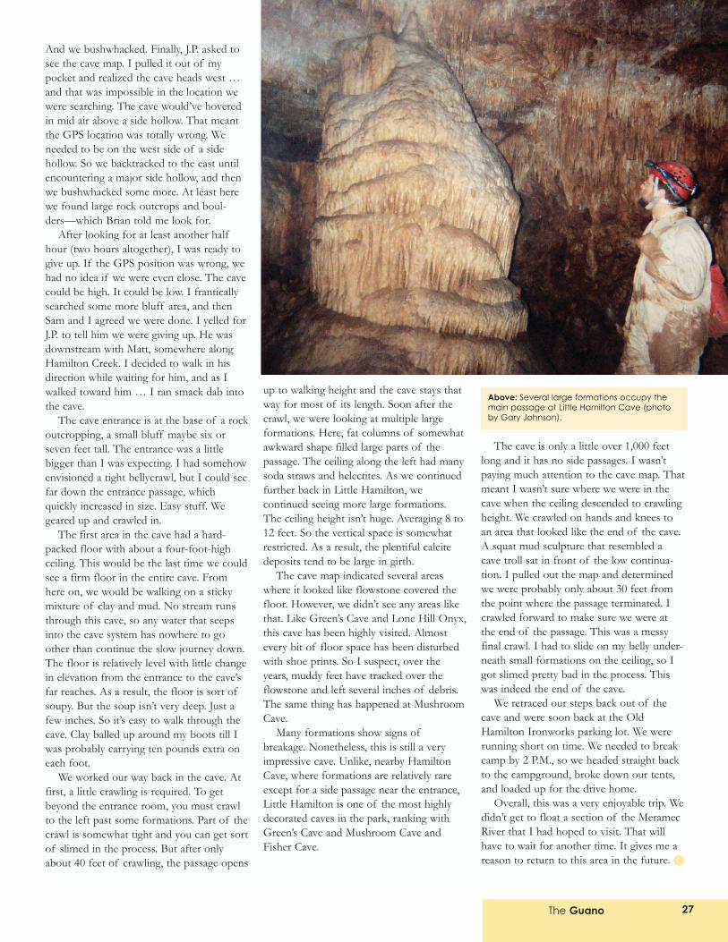
The Guano 27
And we bushwhacked. Finally, J.P. asked tosee the cave map. I pulled it out of mypocket and realized the cave heads west �and that was impossible in the location wewere searching. The cave would�ve hoveredin mid air above a side hollow. That meantthe GPS location was totally wrong. Weneeded to be on the west side of a sidehollow. So we backtracked to the east untilencountering a major side hollow, and thenwe bushwhacked some more. At least herewe found large rock outcrops and boul-ders�which Brian told me look for.
After looking for at least another halfhour (two hours altogether), I was ready togive up. If the GPS position was wrong, wehad no idea if we were even close. The cavecould be high. It could be low. I franticallysearched some more bluff area, and thenSam and I agreed we were done. I yelled forJ.P. to tell him we were giving up. He wasdownstream with Matt, somewhere alongHamilton Creek. I decided to walk in hisdirection while waiting for him, and as Iwalked toward him � I ran smack dab intothe cave.
The cave entrance is at the base of a rockoutcropping, a small bluff maybe six orseven feet tall. The entrance was a littlebigger than I was expecting. I had somehowenvisioned a tight bellycrawl, but I could seefar down the entrance passage, whichquickly increased in size. Easy stuff. Wegeared up and crawled in.
The first area in the cave had a hard-packed floor with about a four-foot-highceiling. This would be the last time we couldsee a firm floor in the entire cave. Fromhere on, we would be walking on a stickymixture of clay and mud. No stream runsthrough this cave, so any water that seepsinto the cave system has nowhere to goother than continue the slow journey down.The floor is relatively level with little changein elevation from the entrance to the cave�sfar reaches. As a result, the floor is sort ofsoupy. But the soup isn�t very deep. Just afew inches. So it�s easy to walk through thecave. Clay balled up around my boots till Iwas probably carrying ten pounds extra oneach foot.
We worked our way back in the cave. Atfirst, a little crawling is required. To getbeyond the entrance room, you must crawlto the left past some formations. Part of thecrawl is somewhat tight and you can get sortof slimed in the process. But after onlyabout 40 feet of crawling, the passage opens
up to walking height and the cave stays thatway for most of its length. Soon after thecrawl, we were looking at multiple largeformations. Here, fat columns of somewhatawkward shape filled large parts of thepassage. The ceiling along the left had manysoda straws and helectites. As we continuedfurther back in Little Hamilton, wecontinued seeing more large formations.The ceiling height isn�t huge. Averaging 8 to12 feet. So the vertical space is somewhatrestricted. As a result, the plentiful calcitedeposits tend to be large in girth.
The cave map indicated several areaswhere it looked like flowstone covered thefloor. However, we didn�t see any areas likethat. Like Green�s Cave and Lone Hill Onyx,this cave has been highly visited. Almostevery bit of floor space has been disturbedwith shoe prints. So I suspect, over theyears, muddy feet have tracked over theflowstone and left several inches of debris.The same thing has happened at MushroomCave.
Many formations show signs ofbreakage. Nonetheless, this is still a veryimpressive cave. Unlike, nearby HamiltonCave, where formations are relatively rareexcept for a side passage near the entrance,Little Hamilton is one of the most highlydecorated caves in the park, ranking withGreen�s Cave and Mushroom Cave andFisher Cave.
The cave is only a little over 1,000 feetlong and it has no side passages. I wasn�tpaying much attention to the cave map. Thatmeant I wasn�t sure where we were in thecave when the ceiling descended to crawlingheight. We crawled on hands and knees toan area that looked like the end of the cave.A squat mud sculpture that resembled acave troll sat in front of the low continua-tion. I pulled out the map and determinedwe were probably only about 30 feet fromthe point where the passage terminated. Icrawled forward to make sure we were atthe end of the passage. This was a messyfinal crawl. I had to slide on my belly under-neath small formations on the ceiling, so Igot slimed pretty bad in the process. Thiswas indeed the end of the cave.
We retraced our steps back out of thecave and were soon back at the OldHamilton Ironworks parking lot. We wererunning short on time. We needed to breakcamp by 2 P.M., so we headed straight backto the campground, broke down our tents,and loaded up for the drive home.
Overall, this was a very enjoyable trip. Wedidn�t get to float a section of the MeramecRiver that I had hoped to visit. That willhave to wait for another time. It gives me areason to return to this area in the future.
Above: Several large formations occupy themain passage at Little Hamilton Cave (photoby Gary Johnson).
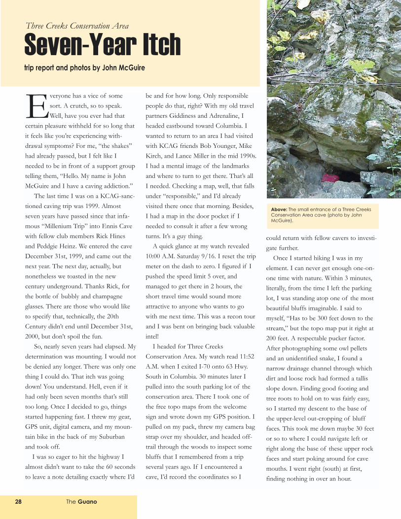
Everyone has a vice of somesort. A crutch, so to speak.Well, have you ever had that
certain pleasure withheld for so long thatit feels like you�re experiencing with-drawal symptoms? For me, �the shakes�had already passed, but I felt like Ineeded to be in front of a support grouptelling them, �Hello. My name is JohnMcGuire and I have a caving addiction.�
The last time I was on a KCAG-sanc-tioned caving trip was 1999. Almostseven years have passed since that infa-mous �Millenium Trip� into Ennis Cavewith fellow club members Rick Hinesand Peddgie Heinz. We entered the caveDecember 31st, 1999, and came out thenext year. The next day, actually, butnonetheless we toasted in the newcentury underground. Thanks Rick, forthe bottle of bubbly and champagneglasses. There are those who would liketo specify that, technically, the 20thCentury didn�t end until December 31st,2000, but don�t spoil the fun.
So, nearly seven years had elapsed. Mydetermination was mounting. I would notbe denied any longer. There was only onething I could do. That itch was goingdown! You understand. Hell, even if ithad only been seven months that�s stilltoo long. Once I decided to go, thingsstarted happening fast. I threw my gear,GPS unit, digital camera, and my moun-tain bike in the back of my Suburbanand took off.
I was so eager to hit the highway Ialmost didn�t want to take the 60 secondsto leave a note detailing exactly where I�d
be and for how long. Only responsiblepeople do that, right? With my old travelpartners Giddiness and Adrenaline, Iheaded eastbound toward Columbia. Iwanted to return to an area I had visitedwith KCAG friends Bob Younger, MikeKirch, and Lance Miller in the mid 1990s.I had a mental image of the landmarksand where to turn to get there. That�s allI needed. Checking a map, well, that fallsunder �responsible,� and I�d alreadyvisited there once that morning. Besides,I had a map in the door pocket if Ineeded to consult it after a few wrongturns. It�s a guy thing.
A quick glance at my watch revealed10:00 A.M. Saturday 9/16. I reset the tripmeter on the dash to zero. I figured if Ipushed the speed limit 5 over, andmanaged to get there in 2 hours, theshort travel time would sound moreattractive to anyone who wants to gowith me next time. This was a recon tourand I was bent on bringing back valuableintel!
I headed for Three CreeksConservation Area. My watch read 11:52A.M. when I exited I-70 onto 63 Hwy.South in Columbia. 30 minutes later Ipulled into the south parking lot of theconservation area. There I took one ofthe free topo maps from the welcomesign and wrote down my GPS position. Ipulled on my pack, threw my camera bagstrap over my shoulder, and headed off-trail through the woods to inspect somebluffs that I remembered from a tripseveral years ago. If I encountered acave, I�d record the coordinates so I
could return with fellow cavers to investi-gate further.
Once I started hiking I was in myelement. I can never get enough one-on-one time with nature. Within 3 minutes,literally, from the time I left the parkinglot, I was standing atop one of the mostbeautiful bluffs imaginable. I said tomyself, �Has to be 300 feet down to thestream,� but the topo map put it right at200 feet. A respectable pucker factor.After photographing some owl pelletsand an unidentified snake, I found anarrow drainage channel through whichdirt and loose rock had formed a tallisslope down. Finding good footing andtree roots to hold on to was fairly easy,so I started my descent to the base ofthe upper-level out-cropping of blufffaces. This took me down maybe 30 feetor so to where I could navigate left orright along the base of these upper rockfaces and start poking around for cavemouths. I went right (south) at first,finding nothing in over an hour.
The Guano28
Above: The small entrance of a Three CreeksConservation Area cave (photo by JohnMcGuire).
Seven-Year ItchThree Creeks Conservation Area
trip report and photos by John McGuire
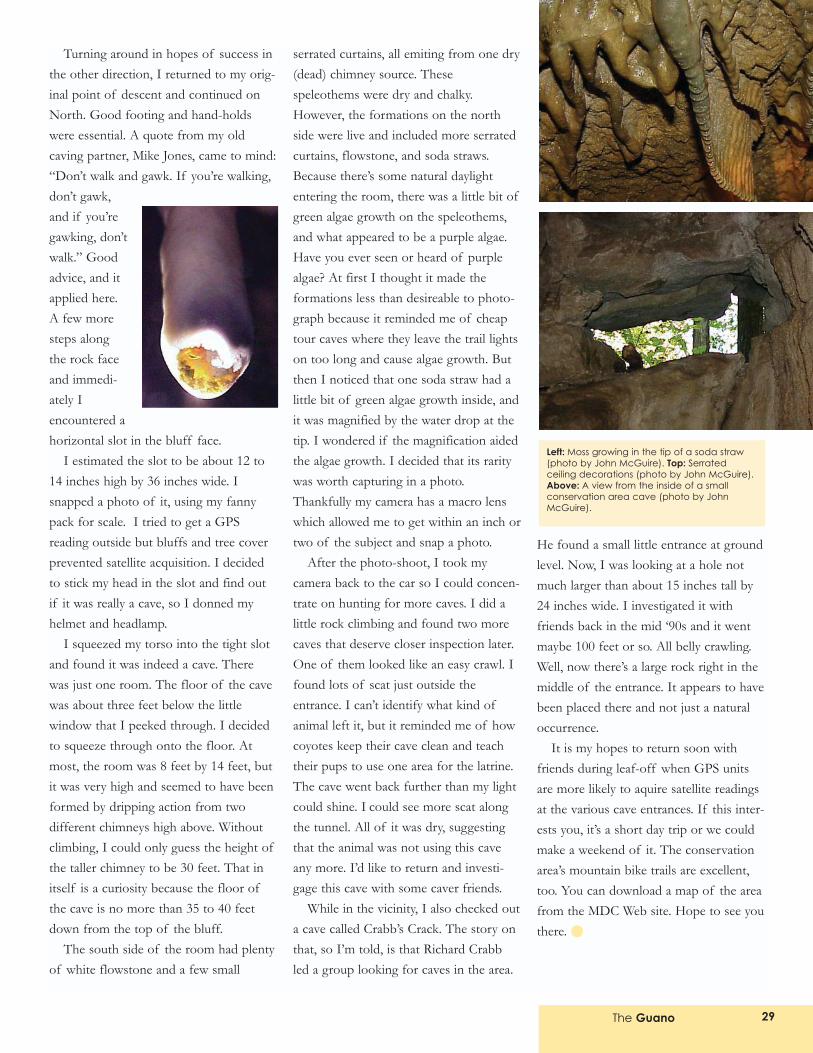
Turning around in hopes of success inthe other direction, I returned to my orig-inal point of descent and continued onNorth. Good footing and hand-holdswere essential. A quote from my oldcaving partner, Mike Jones, came to mind:�Don�t walk and gawk. If you�re walking,don�t gawk,and if you�regawking, don�twalk.� Goodadvice, and itapplied here.A few moresteps alongthe rock faceand immedi-ately Iencountered ahorizontal slot in the bluff face.
I estimated the slot to be about 12 to14 inches high by 36 inches wide. Isnapped a photo of it, using my fannypack for scale. I tried to get a GPSreading outside but bluffs and tree coverprevented satellite acquisition. I decidedto stick my head in the slot and find outif it was really a cave, so I donned myhelmet and headlamp.
I squeezed my torso into the tight slotand found it was indeed a cave. Therewas just one room. The floor of the cavewas about three feet below the littlewindow that I peeked through. I decidedto squeeze through onto the floor. Atmost, the room was 8 feet by 14 feet, butit was very high and seemed to have beenformed by dripping action from twodifferent chimneys high above. Withoutclimbing, I could only guess the height ofthe taller chimney to be 30 feet. That initself is a curiosity because the floor ofthe cave is no more than 35 to 40 feetdown from the top of the bluff.
The south side of the room had plentyof white flowstone and a few small
serrated curtains, all emiting from one dry(dead) chimney source. Thesespeleothems were dry and chalky.However, the formations on the northside were live and included more serratedcurtains, flowstone, and soda straws.Because there�s some natural daylightentering the room, there was a little bit ofgreen algae growth on the speleothems,and what appeared to be a purple algae.Have you ever seen or heard of purplealgae? At first I thought it made theformations less than desireable to photo-graph because it reminded me of cheaptour caves where they leave the trail lightson too long and cause algae growth. Butthen I noticed that one soda straw had alittle bit of green algae growth inside, andit was magnified by the water drop at thetip. I wondered if the magnification aidedthe algae growth. I decided that its raritywas worth capturing in a photo.Thankfully my camera has a macro lenswhich allowed me to get within an inch ortwo of the subject and snap a photo.
After the photo-shoot, I took mycamera back to the car so I could concen-trate on hunting for more caves. I did alittle rock climbing and found two morecaves that deserve closer inspection later.One of them looked like an easy crawl. Ifound lots of scat just outside theentrance. I can�t identify what kind ofanimal left it, but it reminded me of howcoyotes keep their cave clean and teachtheir pups to use one area for the latrine.The cave went back further than my lightcould shine. I could see more scat alongthe tunnel. All of it was dry, suggestingthat the animal was not using this caveany more. I�d like to return and investi-gage this cave with some caver friends.
While in the vicinity, I also checked outa cave called Crabb�s Crack. The story onthat, so I�m told, is that Richard Crabbled a group looking for caves in the area.
He found a small little entrance at groundlevel. Now, I was looking at a hole notmuch larger than about 15 inches tall by24 inches wide. I investigated it withfriends back in the mid �90s and it wentmaybe 100 feet or so. All belly crawling.Well, now there�s a large rock right in themiddle of the entrance. It appears to havebeen placed there and not just a naturaloccurrence.
It is my hopes to return soon withfriends during leaf-off when GPS unitsare more likely to aquire satellite readingsat the various cave entrances. If this inter-ests you, it�s a short day trip or we couldmake a weekend of it. The conservationarea�s mountain bike trails are excellent,too. You can download a map of the areafrom the MDC Web site. Hope to see youthere.
The Guano 29
Left: Moss growing in the tip of a soda straw(photo by John McGuire). Top: Serratedceiling decorations (photo by John McGuire).Above: A view from the inside of a smallconservation area cave (photo by JohnMcGuire).
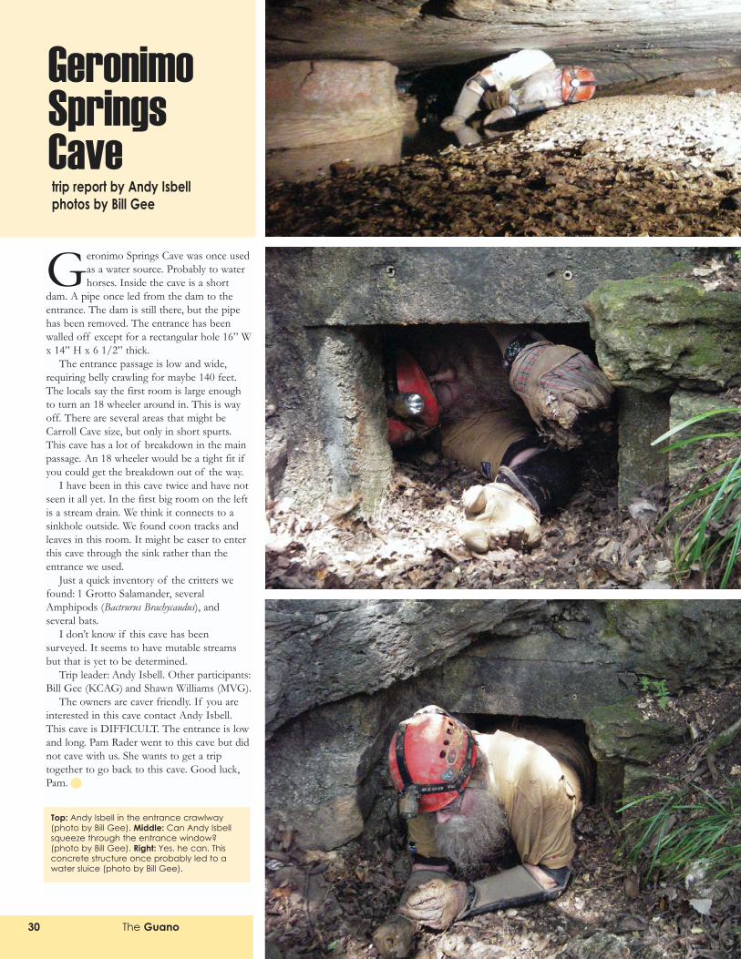
The Guano30
Geronimo Springs Cave was once usedas a water source. Probably to waterhorses. Inside the cave is a short
dam. A pipe once led from the dam to theentrance. The dam is still there, but the pipehas been removed. The entrance has beenwalled off except for a rectangular hole 16� Wx 14� H x 6 1/2� thick.
The entrance passage is low and wide,requiring belly crawling for maybe 140 feet.The locals say the first room is large enoughto turn an 18 wheeler around in. This is wayoff. There are several areas that might beCarroll Cave size, but only in short spurts.This cave has a lot of breakdown in the mainpassage. An 18 wheeler would be a tight fit ifyou could get the breakdown out of the way.
I have been in this cave twice and have notseen it all yet. In the first big room on the leftis a stream drain. We think it connects to asinkhole outside. We found coon tracks andleaves in this room. It might be easer to enterthis cave through the sink rather than theentrance we used.
Just a quick inventory of the critters wefound: 1 Grotto Salamander, severalAmphipods (Bactrurus Brachycaudus), andseveral bats.
I don�t know if this cave has beensurveyed. It seems to have mutable streamsbut that is yet to be determined.
Trip leader: Andy Isbell. Other participants:Bill Gee (KCAG) and Shawn Williams (MVG).
The owners are caver friendly. If you areinterested in this cave contact Andy Isbell.This cave is DIFFICULT. The entrance is lowand long. Pam Rader went to this cave but didnot cave with us. She wants to get a triptogether to go back to this cave. Good luck,Pam.
Geronimo SpringsCavetrip report by Andy Isbell photos by Bill Gee
Top: Andy Isbell in the entrance crawlway(photo by Bill Gee). Middle: Can Andy Isbellsqueeze through the entrance window?(photo by Bill Gee). Right: Yes, he can. Thisconcrete structure once probably led to awater sluice (photo by Bill Gee).