smart city services over a future internet platform based on internet of things and cloud: the smart...
TRANSCRIPT

energies
Article
Smart City Services over a Future Internet PlatformBased on Internet of Things and Cloud: The SmartParking Case
Jorge Lanza *, Luis Sánchez *, Verónica Gutiérrez, José Antonio Galache, Juan Ramón Santana,Pablo Sotres and Luis Muñoz
Network Planning and Mobile Communications Laboratory, University of Cantabria,Edificio de Ingeniería de Telecomunicaciones, Plaza de la Ciencia s/n, Santander 39005, Spain;[email protected] (V.G.); [email protected] (J.A.G.); [email protected] (J.R.S.);[email protected] (P.S.); [email protected] (L.M.)* Correspondence: [email protected] (J.L.); [email protected] (L.S.);
Tel.: +34-942-200-914 (J.L. & L.S.); Fax: +34-942-201-488 (J.L. & L.S.)
Academic Editor: Jukka HeinonenReceived: 17 May 2016; Accepted: 23 August 2016; Published: 6 September 2016
Abstract: Enhancing the effectiveness of city services and assisting on a more sustainable developmentof cities are two of the crucial drivers of the smart city concept. This paper portrays a field trial thatleverages an internet of things (IoT) platform intended for bringing value to existing and futuresmart city infrastructures. The paper highlights how IoT creates the basis permitting integrationof current vertical city services into an all-encompassing system, which opens new horizons forthe progress of the effectiveness and sustainability of our cities. Additionally, the paper describesa field trial on provisioning of real time data about available parking places both indoor and outdoor.The trial has been carried out at Santander’s (Spain) downtown area. The trial takes advantage ofboth available open data sets as well as of a large-scale IoT infrastructure. The trial is a showcase onhow added-value services can be created on top of the proposed architecture.
Keywords: internet of things (IoT); smart city; smart parking; field-trial
1. Introduction
The smart city paradigm has experienced a fast growth in popularity and attention recently.Recent predictions foresee that the majority of the world’s population will live in urban areas in thefuture (the World Health Organization [1] expects that, by 2050, 70% of the world’s population willlive in cities). Moreover, more than half of the world’s population already lives in cities. An evenhigher percentage can be observed in the industrialized countries, which are the ones that hold thelion’s share of the natural resources consumption. Many studies have highlighted the importance ofenvironment conservation strategies in urban areas [2] as the environmental footprint of these areasis, by large, the deepest one, and world urbanization augurs to make it even deeper. This is, on itsown, enough motivation for researchers and city administrators to find out novel mechanisms thatguarantee the sustainability and efficiency of such complex ecosystems.
Cities encompass a plethora of systems, people, organizations, services, and city infrastructuresthat are becoming more and more integrated into a cyber-physical scenario. However, coordinationbetween the different sub-systems is still poor and does not reach the operative level but remainsmainly at a strategic level. A set of standalone public services is run without cross-fertilizationbetween them. Several different approaches on how to achieve the smart city vision have been recentlyproposed [3–5]. However, there is a common aspect that all of them share. The capacity of gettingand sharing contextual information on how the different city sub-systems (e.g., traffic, energy, waste
Energies 2016, 9, 719; doi:10.3390/en9090719 www.mdpi.com/journal/energies
Energies 2016, 9, 719 2 of 14
management, etc.) are behaving has a crucial importance. Hence, information and communicationtechnologies (ICT) are perceived as fundamental enablers for the transformation of urban regions intosmart cities. Two of these technologies, namely internet of things (IoT) and big data, have a majorposition among all of them [6,7]. The capacity to “sense the city” and access all this informationto provide added-value services based on the knowledge derived from it are critical to achievingthe smart city vision. This revolution is still only in its infancy as suitable infrastructures are beingdeployed and important investments are being made in city infrastructures. The ability of existing andfuture city infrastructure to communicate must be exploited to enable homogeneous management ofthat infrastructure and open access to the available information. This information will be the basis fornovel added-value services that is not possible to deliver nowadays as data is not accessible.
In this context, the SmartSantander project [8] have set-up an experimental test facility forthe research and experimentation of key enabling technologies, services, and applications for theIoT in the context of a smart city. However, this testbed also supports the validation of new IoTapplications and the evaluation of service experience and performance with real end-users involvedin the process. In this sense, this paper presents the implementation of a smart parking serviceand the Key Performance Indicators (KPIs) extracted from the field trial carried out are presentedand discussed.
The smart parking service implemented has been developed and deployed on top of the smartcity platform that has been built around the SmartSantader IoT infrastructure. Hence, in addition tothe description of the smart parking service, this article will briefly summarize the smart city platformarchitecture. Further description and motivation for the platform design and implementation can befound in the references provided but, for the sake of self-completeness, main highlights are brought tothis paper.
The remainder of the paper is structured as follows. Section 2 presents some related worksand activities. The review is centered on existing activities, both in standardization and research,on similar IoT platforms and comparable IoT infrastructure deployments so that the reader can havea benchmark to assess the interest of the use case described in the paper. Section 3 briefly summarizesthe underlaying infrastructure focusing on the devices mainly supporting the smart parking service.It also sketches the smart city platform supporting the service. In Section 4, the smart parking serviceis described. The implementation of the applications supporting the service and the KPIs analyzedfor validating the overall system is presented. Finally, Section 5 concludes the article, highlighting itsmain contributions.
2. Related Work
There are two main ways of understanding the smart city term [9]. On the one hand,a technology-oriented one that considers a ubiquitous computing scenario where a plethora ofdevices are embedded into the very fabric of urban environments [10–12]. On the other hand, a moreeconomic-oriented vision that focuses on the opportunities that are created for the development ofa new knowledge-based economy [13]. However, there is an aspect that appears in both of them.They both put in a central role the ability to capture data related to the city operations and analyze it togenerate added-value information that will optimize these operations. IoT is seen as a key enablingtechnology in satisfying these functionalities.
Firstly, it is important to pay attention to the activities that are being carried out in the differentIoT-related existing standardization bodies. Most of the work in terms of standardization has focusedon the Machine-to-Machine (M2M) communications domain. ETSI M2M TG or the more recentlycreated OneM2M [14] have been working to standardize a common M2M service layer platform forglobally applicable and access-independent M2M services. Other standardizations for a common M2Morients their specifications to a more system-level view and considers a generic scenario demandingcontext information management. The specifications from open mobile alliance (OMA) in terms of nextgeneration services interfaces (NGSI) gathered in the two standards, OMA NGSI-9 and OMA NGSI-10,
Energies 2016, 9, 719 3 of 14
are at the core of the specification for the IoT Chapter of the FIWARE (https://www.fiware.org/)project. This project aims to establish a reference set of Future Internet enablers for the development ofsmart applications in multiple sectors.
Indeed, the literature abounds in software platforms that are horizontal to the IoT applicationdomains. The IoT architectural reference model (ARM) developed within the IoT-A project [15] definesa reference model for IoT platforms. It specifies a domain model that identifies the key concepts tobe supported in an IoT scenario and a functional model that describes the key functional groups thathave to be observed in the specification of an actual IoT platform [16]. For example, Kiljander et al. [17]make use of the guidelines designed by the IoT ARM and extend them by introducing semantic webenablement technologies to support interoperability at IoT scenarios. Undeniably, interoperabilityis a particularly important aspect that has to be taken into account since heterogeneity is one of themain challenges to be addressed in IoT environments. The IoT platform that is presented in this paperalso takes in part the reference of the IoT ARM for supporting the virtualization of the physical worldentities. They are exposed through services that offer, in an abstract manner, the values captured bythe underlaying sensors or the actions enabled by available actuators. In the case described in thisarticle, parking lots are virtualized and its occupancy is represented as an abstract property whichis fed by the sensors monitoring that parking spaces. Another important facet of IoT that has tobe addressed by any IoT platform is the scalability issue. In this sense, the scale of IoT is expectedto pose important challenges to any solution in this area. Mitton et al. [7] go a step further in theaforementioned physical-world abstraction and introduce the cloud concept to coin the cloud of things(COT) paradigm. The architecture for that system is certainly aligned with the solution proposedin this paper. However, work in this approach within the VITAL project [18] has not, to the bestof our knowledge, been challenged against an actual large-scale deployment. Specific to the smartcity development, in more recent works Vögler et al. [19] considers the software platform to workas operating systems do in modern computers, offering in an abstract and high-level manner theunderlying resources and management tasks. They follow a similar approach as the one presented inthis paper to address the main challenges in a smart city scenario, namely, homogenization of access toresources, management of massive amount of resources, and exposure of the services offered by theseresources. Although the approach is certainly convergent, this work is only presented as a design effortand does not identify how each of its architecture components are actually implemented and deployed.
Precisely, this is an aspect in which the case and platform presented in this paper really distinguishfrom existing works. Few smart city deployments are available nowadays to eventually validateproposed mechanisms addressing horizontal solutions or even specific technologies for the smartcity vision. Specifically related to the smart parking use case presented in this paper, in [20]a cloud-based car parking middleware for IoT-based smart cities is presented. Abundant details on theimplementation of the smart parking system is provided with special emphasis on the cloud aspectand its realization. While the work presented is focused on the smart parking system, the architecturefollows an analogous approach to the one proposed in this article which implicitly could supportadditional use cases, although not mentioned explicitly. However, the validation of the system is basedon randomly generated scenarios.
The case of Barcelona is presented in [21]. Many smart city initiatives have been organized thereunder a common strategy for the city but they are somehow independent. This fails on anotheraspect that we believe is critical for realizing the smart city vision, namely the federation of all citysystems in one holistic platform over which added-value and efficiency optimization services can beprovided. Open data approaches are also a trend in this respect but without appropriate organizationand architecture, the value of the information stored therein largely decreases. Oulu is another examplefor the employment of ICT technologies [22] to enhance efficiency and well-being in the city. In [23],some of the experiences implemented in this city are presented. However, they are focused on specificverticals and there is a lack of a common platform behind all of them. There are many projected pilotsmart cities under development. The Songdo city initiative [24], a fully ubiquitous city in South Korea,

Energies 2016, 9, 719 4 of 14
began in 2001 and was expected to be complete by 2015, the PlanIT Valley [25] in Northern Portugal,another pilot project for a fully ubiquitous city built from the ground up, scheduled for 2015, or theFujisawa Sustainable Smart Town [26] have not actually gone into a tangible large scale deployment atthe moment. In Malaga, another smart city action in Spain, the focus has been put on the smart gridaspects [27] with the aim to achieve a reduction in the carbon dioxide emissions. While the currentdeployment already includes more than 17,000 deployed smart meters, data flows are tailored for eachof the implemented use cases thus reducing the challenges regarding the management of data mainlyfrom the variety and heterogeneity viewpoints.
3. Cloud and Internet of Things (IoT)-Enabled Smart City Platform
The following sections briefly presents the context in which the smart parking service field trialhas been developed. Specifically, it summarizes the overall SmartSantander physical deployment,making emphasis on the part supporting the parking service, and sketches the IoT platform thatenables the parking service provision.
3.1. Deployed IoT Infrastructure Overview
The insights into this deployment and details of the installed devices have already been describedin [28,29]. In order to make the article self-contained, this paper will present a brief summaryand extend these by introducing detailed information on the IoT devices associated with the smartparking service.
The SmartSantander testbed comprises more than 12,000 sensing devices including regularsensors, NFC tag/QR code labels, as well as smartphones from citizens. Sensors are deployed bothat fixed locations (lampposts, buildings’ facades, bus stops) as well as onboard of mobile vehicles(buses, taxis). The deployment has an intentionally high density of IoT devices in the city center(a 1 km2 area) in order to achieve the maximum possible impact on the citizens but thanks to theembarked sensors, it has the capacity to get information from most of the city extension. Every markershown in Figure 1 represents a sensing device which might be equipped with several sensors.
Energies 2016, 9, 719 4 of 14
focus has been put on the smart grid aspects [27] with the aim to achieve a reduction in the carbon
dioxide emissions. While the current deployment already includes more than 17,000 deployed smart
meters, data flows are tailored for each of the implemented use cases thus reducing the challenges
regarding the management of data mainly from the variety and heterogeneity viewpoints.
3. Cloud and Internet of Things (IoT)-Enabled Smart City Platform
The following sections briefly presents the context in which the smart parking service field trial
has been developed. Specifically, it summarizes the overall SmartSantander physical deployment,
making emphasis on the part supporting the parking service, and sketches the IoT platform that
enables the parking service provision.
3.1. Deployed IoT Infrastructure Overview
The insights into this deployment and details of the installed devices have already been
described in [28,29]. In order to make the article self-contained, this paper will present a brief
summary and extend these by introducing detailed information on the IoT devices associated with
the smart parking service.
The SmartSantander testbed comprises more than 12,000 sensing devices including regular
sensors, NFC tag/QR code labels, as well as smartphones from citizens. Sensors are deployed both at
fixed locations (lampposts, buildings’ facades, bus stops) as well as onboard of mobile vehicles
(buses, taxis). The deployment has an intentionally high density of IoT devices in the city center (a 1
km2 area) in order to achieve the maximum possible impact on the citizens but thanks to the
embarked sensors, it has the capacity to get information from most of the city extension. Every marker
shown in Figure 1 represents a sensing device which might be equipped with several sensors.
Figure 1. Santander internet of things (IoT) infrastructure deployment excerpt view.
As already mentioned, the testbed, among other objectives, aims at enabling the test and
validation of new IoT-based added-value smart city services. In this sense, for the deployment of the
infrastructure specific application areas have been selected based on their high potential impact on
the citizens. The domains of interest are:
Environmental monitoring: Fixed and mobile sensors gather observations on several phenomena
related to the environmental conditions such as temperature, relative humidity, noise, air
pollution, or electromagnetic fields.
Figure 1. Santander internet of things (IoT) infrastructure deployment excerpt view.
As already mentioned, the testbed, among other objectives, aims at enabling the test and validationof new IoT-based added-value smart city services. In this sense, for the deployment of the infrastructurespecific application areas have been selected based on their high potential impact on the citizens.The domains of interest are:
Energies 2016, 9, 719 5 of 14
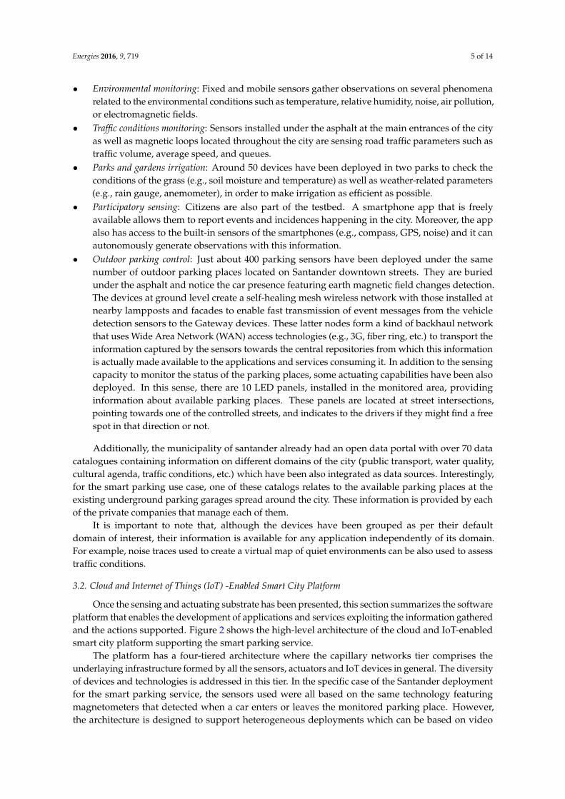
• Environmental monitoring: Fixed and mobile sensors gather observations on several phenomenarelated to the environmental conditions such as temperature, relative humidity, noise, air pollution,or electromagnetic fields.
• Traffic conditions monitoring: Sensors installed under the asphalt at the main entrances of the cityas well as magnetic loops located throughout the city are sensing road traffic parameters such astraffic volume, average speed, and queues.
• Parks and gardens irrigation: Around 50 devices have been deployed in two parks to check theconditions of the grass (e.g., soil moisture and temperature) as well as weather-related parameters(e.g., rain gauge, anemometer), in order to make irrigation as efficient as possible.
• Participatory sensing: Citizens are also part of the testbed. A smartphone app that is freelyavailable allows them to report events and incidences happening in the city. Moreover, the appalso has access to the built-in sensors of the smartphones (e.g., compass, GPS, noise) and it canautonomously generate observations with this information.
• Outdoor parking control: Just about 400 parking sensors have been deployed under the samenumber of outdoor parking places located on Santander downtown streets. They are buriedunder the asphalt and notice the car presence featuring earth magnetic field changes detection.The devices at ground level create a self-healing mesh wireless network with those installed atnearby lampposts and facades to enable fast transmission of event messages from the vehicledetection sensors to the Gateway devices. These latter nodes form a kind of backhaul networkthat uses Wide Area Network (WAN) access technologies (e.g., 3G, fiber ring, etc.) to transport theinformation captured by the sensors towards the central repositories from which this informationis actually made available to the applications and services consuming it. In addition to the sensingcapacity to monitor the status of the parking places, some actuating capabilities have been alsodeployed. In this sense, there are 10 LED panels, installed in the monitored area, providinginformation about available parking places. These panels are located at street intersections,pointing towards one of the controlled streets, and indicates to the drivers if they might find a freespot in that direction or not.
Additionally, the municipality of santander already had an open data portal with over 70 datacatalogues containing information on different domains of the city (public transport, water quality,cultural agenda, traffic conditions, etc.) which have been also integrated as data sources. Interestingly,for the smart parking use case, one of these catalogs relates to the available parking places at theexisting underground parking garages spread around the city. These information is provided by eachof the private companies that manage each of them.
It is important to note that, although the devices have been grouped as per their defaultdomain of interest, their information is available for any application independently of its domain.For example, noise traces used to create a virtual map of quiet environments can be also used to assesstraffic conditions.
3.2. Cloud and Internet of Things (IoT) -Enabled Smart City Platform
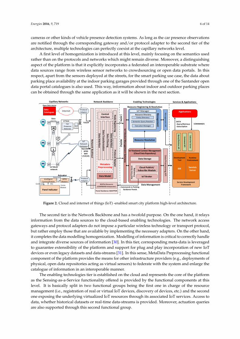
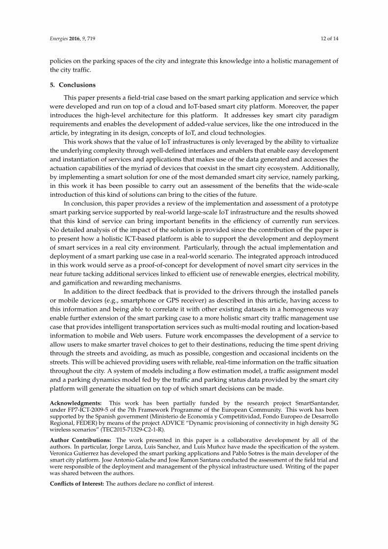
Once the sensing and actuating substrate has been presented, this section summarizes the softwareplatform that enables the development of applications and services exploiting the information gatheredand the actions supported. Figure 2 shows the high-level architecture of the cloud and IoT-enabledsmart city platform supporting the smart parking service.
The platform has a four-tiered architecture where the capillary networks tier comprises theunderlaying infrastructure formed by all the sensors, actuators and IoT devices in general. The diversityof devices and technologies is addressed in this tier. In the specific case of the Santander deploymentfor the smart parking service, the sensors used were all based on the same technology featuringmagnetometers that detected when a car enters or leaves the monitored parking place. However,the architecture is designed to support heterogeneous deployments which can be based on video
Energies 2016, 9, 719 6 of 14
cameras or other kinds of vehicle presence detection systems. As long as the car presence observationsare notified through the corresponding gateway and/or protocol adapter to the second tier of thearchitecture, multiple technologies can perfectly coexist at the capillary networks level.
A first level of homogenization is introduced at this level, mainly focusing on the semantics usedrather than on the protocols and networks which might remain diverse. Moreover, a distinguishingaspect of the platform is that it explicitly incorporates a federated an interoperable substrate wheredata sources range from wireless sensor networks to crowdsourcing or open data portals. In thisrespect, apart from the sensors deployed at the streets, for the smart parking use case, the data aboutparking place availability at the indoor parking garages provided through one of the Santander opendata portal catalogues is also used. This way, information about indoor and outdoor parking placescan be obtained through the same application as it will be shown in the next section.
Energies 2016, 9, 719 6 of 14
data sources range from wireless sensor networks to crowdsourcing or open data portals. In this
respect, apart from the sensors deployed at the streets, for the smart parking use case, the data about
parking place availability at the indoor parking garages provided through one of the Santander open
data portal catalogues is also used. This way, information about indoor and outdoor parking places
can be obtained through the same application as it will be shown in the next section.
Figure 2. Cloud and internet of things (IoT) -enabled smart city platform high-level architecture.
The second tier is the Network Backbone and has a twofold purpose. On the one hand, it relays
information from the data sources to the cloud-based enabling technologies. The network access
gateways and protocol adapters do not impose a particular wireless technology or transport protocol,
but rather employ those that are available by implementing the necessary adapters. On the other hand,
it completes the data modelling homogenization. Modelling of information is critical to correctly
handle and integrate diverse sources of information [30]. In this tier, corresponding meta-data is
leveraged to guarantee extensibility of the platform and support for plug and play incorporation of
new IoT devices or even legacy datasets and data-streams [31]. In this sense, MetaData Preprocessing
functional component of the platform provides the means for other infrastructure providers (e.g.,
deployments of physical, open data repositories acting as virtual sensors) to federate with the system
and enlarge the catalogue of information in an interoperable manner.
The enabling technologies tier is established on the cloud and represents the core of the platform
as the Sensing-as-a-Service functionality offered is provided by the functional components at this
level. It is basically split in two functional groups being the first one in charge of the resource
management (i.e., registration of real or virtual IoT devices, discovery of devices, etc.) and the second
one exposing the underlying virtualized IoT resources through its associated IoT services. Access to
data, whether historical datasets or real-time data-streams is provided. Moreover, actuation queries
are also supported through this second functional group.
Last but not least, the Services and Applications tier has again a twofold objective. Firstly, it
provides the tools to enable easy access to the Enabling Technologies services. Secondly, and critically
important, it enables a cloud of services concept by facilitating the generation of new applications
and services from software artefacts already available, creating new services by composition with
those already existing.
Data Catalogues
Panel Indicator
Intelligent Control Module
GPRSModem
Command InfoInfo
Command
Semantic Query Resolver
Entity Directory
Resource Directory
Execution Manager
Ma
na
ge
me
nt
Data P
rovisio
nin
g AP
IM
an
agem
ent A
PI
Resource Registering & Resolution
IoT NetworkGateway
3G/UMTSGPRSWiFi
(TCP/IP)
Protocol Adapter
Capillary Networks Network Backbone
Internet
IoT
IoT
IoT
IoT
IoT
IoT
IoT
IoT
IoT Mesh network
Actuator
Open Data source
IoT Manager
Comm. Module
Car Presence Detector
IoT Node
Comm. Module
Data source
Protocol Adapter
Panel Guidance ADAPTER
RESTful Resource (COMMAND Interpreter)
Ne
two
rk Ba
ckhau
l
Data Model
Control Interface
Nod
e Registering
Pro
tocol A
dap
ter
Data In
terface
Data Filte
ring
Data Transform
atio
n
Data In
terface
Metadata Preprocessing
TCP/IP
IoT D
evice M
anagem
ent G
ateway
{ JSON
}R
ESTful
Cloud Publish/Subscribe Module
Rea
l Tim
e E
ven
t P
roce
ssin
g
IoT Broker
IoT Backend Context Management(Cloud Data Repository)
Data Management
Data Storage
Resource Resolution
Enabling Technologies
Su
bscrito
r Se
rve
r
Service Development Framework
Runtime Environment
Applications
Development Tool
Servlets Server
IDE
Com
man
d AP
I
Commands to Parking Guidance Panels
Qu
ery/Re
triev
e A
PI
COMMANDSDATA-Query/Retrieve-Subscription
Services & Applications
Figure 2. Cloud and internet of things (IoT) -enabled smart city platform high-level architecture.
The second tier is the Network Backbone and has a twofold purpose. On the one hand, it relaysinformation from the data sources to the cloud-based enabling technologies. The network accessgateways and protocol adapters do not impose a particular wireless technology or transport protocol,but rather employ those that are available by implementing the necessary adapters. On the other hand,it completes the data modelling homogenization. Modelling of information is critical to correctly handleand integrate diverse sources of information [30]. In this tier, corresponding meta-data is leveragedto guarantee extensibility of the platform and support for plug and play incorporation of new IoTdevices or even legacy datasets and data-streams [31]. In this sense, MetaData Preprocessing functionalcomponent of the platform provides the means for other infrastructure providers (e.g., deployments ofphysical, open data repositories acting as virtual sensors) to federate with the system and enlarge thecatalogue of information in an interoperable manner.
The enabling technologies tier is established on the cloud and represents the core of the platformas the Sensing-as-a-Service functionality offered is provided by the functional components at thislevel. It is basically split in two functional groups being the first one in charge of the resourcemanagement (i.e., registration of real or virtual IoT devices, discovery of devices, etc.) and the secondone exposing the underlying virtualized IoT resources through its associated IoT services. Access todata, whether historical datasets or real-time data-streams is provided. Moreover, actuation queriesare also supported through this second functional group.
Energies 2016, 9, 719 7 of 14
Last but not least, the Services and Applications tier has again a twofold objective. Firstly,it provides the tools to enable easy access to the Enabling Technologies services. Secondly, and criticallyimportant, it enables a cloud of services concept by facilitating the generation of new applications andservices from software artefacts already available, creating new services by composition with thosealready existing.
4. Case Study: Smart Parking Trial
Modern cities traffic is one of the main challenges that municipalities have to face and it is notan easy task as it has many facets. Among them, management of limited parking including specificspaces for people with disabilities, control of load and unload areas, and traffic prediction are the mostrelevant elements to be considered.
4.1. Scenario Motivation
In the case of indoor parking lots, it is not unusual to have detailed information about theparking spaces availability. However, this is different when the outdoor parking areas are considered.In this latter case, similar information is rarely available. In Santander, the service of limited parkingmanagement consists in the time regulation of the parking places in the center of the city according tothe municipal traffic ordinance (MTO). A private company is in charge of its control, but its services arelimited to the management of the user payment management and the surveillance of parking lot usagein order to put fines to those exceeding the pre-paid parking time or parking without paying at all.
Company staff are in charge of patrolling the areas of the city where the Limited Parking isenforced checking that the cars parked have acquired the ticket and that their parking time has notexpired. The information about when the ticket has been obtained is also available but this is notchecked at all by the guard, thus, there is no record on the actual usage of the parking spaces but justthe control of the payment of the corresponding fee. From the users’ point of view, they need to findan available parking space without any assistance just driving around on the hope of a free space.
This leads to two important drains in the overall service performance. On the one hand,human resources are spent in tedious tasks and important service information is left unobservedand consequently unexploited. On the other hand, drivers have to face the painful process, sometimesfruitless, of finding parking places without further assistance while expending precious time and fuel.
ICT technologies in general and IoT in particular, characterized by its pervasiveness, are becominga very attractive transversal enabler in reducing carbon monoxide (CO) emissions and other pollutants,as well as petrol consumption. Ferromagnetic wireless sensors buried under the asphalt (or any otherparking spaces monitoring technology) can be used to continuously monitor parking spaces statusand detect when cars arrives and leaves such lots. Subsequently, this information can be gatheredand made available in real-time to drivers, traffic control responsible staff and local authorities sothat appropriate actions can be taken (i.e., plan the route to the nearest place, control the usage andestablish policies respectively). Figure 3 shows the satellite view of parking detection sensors deployedat some streets in Santander downtown area.
In this context, the deployment of such an infrastructure and making the correspondinginformation available is expected to: (i) make it easier for drivers to find available spaces in outdoorparking areas by informing them where and how many are available in a specific area and how toreach them (maximizing or minimizing some metrics); (ii) reduce CO emissions as well as petrolconsumption; (iii) facilitate the exploitation of the parking service by allowing extracting occupancymodels useful for further studies in terms of traffic prediction.

Energies 2016, 9, 719 8 of 14
Energies 2016, 9, 719 7 of 14
4. Case Study: Smart Parking Trial
Modern cities traffic is one of the main challenges that Municipalities have to face and it is not
an easy task as it has many facets. Among them, management of limited parking including specific
spaces for people with disabilities, control of load and unload areas, and traffic prediction are the
most relevant elements to be considered.
4.1. Scenario Motivation
In the case of indoor parking lots, it is not unusual to have detailed information about the
parking spaces availability. However, this is different when the outdoor parking areas are
considered. In this latter case, similar information is rarely available. In Santander, the service of
Limited Parking Management consists in the time regulation of the parking places in the center of
the city according to the municipal traffic ordinance (MTO). A private company is in charge of its
control, but its services are limited to the management of the user payment management and the
surveillance of parking lot usage in order to put fines to those exceeding the pre-paid parking time
or parking without paying at all.
Company staff are in charge of patrolling the areas of the city where the Limited Parking is
enforced checking that the cars parked have acquired the ticket and that their parking time has not
expired. The information about when the ticket has been obtained is also available but this is not
checked at all by the guard, thus, there is no record on the actual usage of the parking spaces but just
the control of the payment of the corresponding fee. From the users’ point of view, they need to find
an available parking space without any assistance just driving around on the hope of a free space.
This leads to two important drains in the overall service performance. On the one hand, human
resources are spent in tedious tasks and important service information is left unobserved and
consequently unexploited. On the other hand, drivers have to face the painful process, sometimes
fruitless, of finding parking places without further assistance while expending precious time and fuel.
ICT technologies in general and IoT in particular, characterized by its pervasiveness, are
becoming a very attractive transversal enabler in reducing carbon monoxide (CO) emissions and
other pollutants, as well as petrol consumption. Ferromagnetic wireless sensors buried under the
asphalt (or any other parking spaces monitoring technology) can be used to continuously monitor
parking spaces status and detect when cars arrives and leaves such lots. Subsequently, this
information can be gathered and made available in real-time to drivers, traffic control responsible
staff and local authorities so that appropriate actions can be taken (i.e., plan the route to the nearest
place, control the usage and establish policies respectively). Figure 3 shows the satellite view of
parking detection sensors deployed at some streets in Santander downtown area.
Figure 3. Detailed view of outdoor parking sensors deployment. Figure 3. Detailed view of outdoor parking sensors deployment.
4.2. Smart Parking Service and Smartphone App
In this scenario, the user needs an overview of the real-time occupancy of certain parking areas inthe city of Santander. The main use-cases that the developed smart parking application tried to coverare gathered in Figure 4:
• From their smart phones, tablets, and personal computers the citizens can check the availabilityof parking spaces in the city (both standard and for people with disabilities).
• Citizens can also get a route to a specific parking area; so they can easily reach a certainparking area.
Energies 2016, 9, 719 8 of 14
In this context, the deployment of such an infrastructure and making the corresponding
information available is expected to: (i) make it easier for drivers to find available spaces in outdoor
parking areas by informing them where and how many are available in a specific area and how to
reach them (maximizing or minimizing some metrics); (ii) reduce CO emissions as well as petrol
consumption; (iii) facilitate the exploitation of the parking service by allowing extracting occupancy
models useful for further studies in terms of traffic prediction.
4.2. Smart Parking Service and Smartphone App
In this scenario, the user needs an overview of the real-time occupancy of certain parking areas
in the city of Santander. The main use-cases that the developed smart parking application tried to
cover are gathered in Figure 4:
From their smart phones, tablets, and personal computers the citizens can check the availability
of parking spaces in the city (both standard and for people with disabilities).
Citizens can also get a route to a specific parking area; so they can easily reach a certain parking area.
Figure 4. Smart parking application use case diagram—Citizens’ perspective.
The smart parking application server is the component that holds the information about the
parking availability. It interacts with the smart city platform subscriptor server (Figure 2 at the
services and application tier) component through an asynchronous publish-subscribe mechanism;
i.e., it subscribes for events regarding parking sensors. From these subscriptions, it receives
notifications whenever there is a change of availability in one of the parking spaces. On consuming
this event, the parking server updates its data by setting the availability of a parking space to free or
occupied according to the event received.
The connection between the smart parking application server and the mobile client is done
through a Web Service interface the smart parking application server provides. The mobile client can
request the specified parking lots availability/occupancy as well as get immediate notifications about
just freed spots together with a route to them.
Three mobile applications have been developed: one for the iOS platform; one for the Android
platform; and one for the Windows mobile platform. The three applications have similar
functionalities and usability.
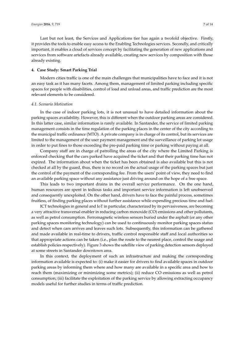
When the smart parking application starts it sends a request to the server for getting the list of
parking lots and its availability. The application displays in a map the information received. The user
can also see the parking lots organized in a list ordered by current distance. For visualizing the
current occupancy status of a certain parking lot, the user can click on the parking lot he/she wants.
A detailed view of the parking lot is loaded as it can be seen in Figure 5. Additionally, the user can
subscribe to be notified of the release of a parking lot in its surroundings (establishing through the
application the radius from its current location). Moreover, users can get a route from their current
location to that parking lot. On clicking on this button, the maps application of the phone is loaded
with the route(s) to the parking lot; this functionality is very useful for the users that are, for instance,
visiting the city and do not know the roads.
Citizens
Visualize parking lots
Visualize parking lots statuses
Visualize route to parking lot
Figure 4. Smart parking application use case diagram—Citizens’ perspective.
The smart parking application server is the component that holds the information about theparking availability. It interacts with the smart city platform subscriptor server (Figure 2 at theservices and application tier) component through an asynchronous publish-subscribe mechanism;i.e., it subscribes for events regarding parking sensors. From these subscriptions, it receives notificationswhenever there is a change of availability in one of the parking spaces. On consuming this event,the parking server updates its data by setting the availability of a parking space to free or occupiedaccording to the event received.
The connection between the smart parking application server and the mobile client is donethrough a Web Service interface the smart parking application server provides. The mobile client canrequest the specified parking lots availability/occupancy as well as get immediate notifications aboutjust freed spots together with a route to them.
Energies 2016, 9, 719 9 of 14
Three mobile applications have been developed: one for the iOS platform; one for the Androidplatform; and one for the Windows mobile platform. The three applications have similar functionalitiesand usability.
When the smart parking application starts it sends a request to the server for getting the list ofparking lots and its availability. The application displays in a map the information received. The usercan also see the parking lots organized in a list ordered by current distance. For visualizing the currentoccupancy status of a certain parking lot, the user can click on the parking lot he/she wants. A detailedview of the parking lot is loaded as it can be seen in Figure 5. Additionally, the user can subscribe to benotified of the release of a parking lot in its surroundings (establishing through the application theradius from its current location). Moreover, users can get a route from their current location to thatparking lot. On clicking on this button, the maps application of the phone is loaded with the route(s)to the parking lot; this functionality is very useful for the users that are, for instance, visiting the cityand do not know the roads.Energies 2016, 9, 719 9 of 14
Figure 5. Detailed view of outdoor parking sensors deployment.
Last but not least, in order to improve the overall service usability, 10 guiding panels have also
been deployed which inform drivers about the available places depending on which route they
choose. The smart parking application server makes use of the command application programming
interface (API) (Figure 2 at the services and application tier) to issue the commands that makes these
panels dynamically change the information displayed on them.
4.3. Field Trial Assessment
In order to improve, the main expected improvements in this scenario are: (i) making it easier
for the driver to find free places in outdoor parking areas by informing her/him where and how many
are available in a specific area and how to reach them (maximizing or minimizing some metrics); and
(ii) easing the use of the parking service by allowing the extraction of occupancy models useful for
further studies in terms of traffic prediction.
In order to evaluate the limited parking scenario from the perspective of the previous indicators,
statistical data obtained from the company in charge of its management were analyzed. The details
about these indicators were marked as confidential by the parking management company and, thus,
cannot be presented in this paper.
The main conclusions that were extracted from the various meetings that were held to better
understand current practices and parking service management experience was that the data
collection methodology could be greatly improved by using the automated process (IoT devices)
provided by SmartSantander (Santander, Spain). The data included from the report was collected
manually, once every 15 days, by the guards who supervise each area in the city. The method
basically consists of counting the places in a specific area and subtracts the result from the available
places in that zone. Based on the obtained result the occupancy average is calculated.
Taking into account the aforementioned aspects, the selected KPIs are shown in Table 1.
Figure 5. Detailed view of outdoor parking sensors deployment.
Last but not least, in order to improve the overall service usability, 10 guiding panels have alsobeen deployed which inform drivers about the available places depending on which route they choose.The smart parking application server makes use of the command application programming interface(API) (Figure 2 at the services and application tier) to issue the commands that makes these panelsdynamically change the information displayed on them.
4.3. Field Trial Assessment
In order to improve, the main expected improvements in this scenario are: (i) making it easier forthe driver to find free places in outdoor parking areas by informing her/him where and how manyare available in a specific area and how to reach them (maximizing or minimizing some metrics);and (ii) easing the use of the parking service by allowing the extraction of occupancy models useful forfurther studies in terms of traffic prediction.
In order to evaluate the limited parking scenario from the perspective of the previous indicators,statistical data obtained from the company in charge of its management were analyzed. The detailsabout these indicators were marked as confidential by the parking management company and,thus, cannot be presented in this paper.
Energies 2016, 9, 719 10 of 14
The main conclusions that were extracted from the various meetings that were held to betterunderstand current practices and parking service management experience was that the data collectionmethodology could be greatly improved by using the automated process (IoT devices) providedby SmartSantander (Santander, Spain). The data included from the report was collected manually,once every 15 days, by the guards who supervise each area in the city. The method basically consistsof counting the places in a specific area and subtracts the result from the available places in that zone.Based on the obtained result the occupancy average is calculated.
Taking into account the aforementioned aspects, the selected KPIs are shown in Table 1.
Table 1. Smart parking key performance indicators evaluated.
KPI Name Description (What?) Relevance (Why?) Methodology (How?)
Efficiency of the useof parking spaces
This KPI measures the usage ofparking spaces, in order toevaluate which parking areasare more in demand by citizensand also the rotation at thosesites. This measurement canhelp to balance the number ofavailable parking sites withina certain parking area.
One of the main goals of thelimited parking managementis to achieve a high turnover ofthe available places.The increase of efficiency isa clear indicator that this goalhas been achieved.
From the information provided bythe system, regarding to the amountof and exact time a site is occupied,it will be possible to estimate theefficiency of the use of parkingspaces. The value highly dependson the day and the hour (rush hour,weekend, etc.), in which themeasurements are carried out.
Service managementsatisfaction
This indicator aims to assess thedegree of satisfaction by thetechnical staff in charge of themanagement of the limitedparking area.
Such an assessment has beenselected as the managers relyon the information providedby the sensors deployed.Hence they are not biased bysubjective opinions oruncontrolled variables ascould be the case wheninterviewing citizens.
The methodology relied on personalinterviews with the technicians incharge of the management andsurveillance of parking areas whohave remarked on the degree ofimprovement achieved by usingthese technologies proposed inrelation to the methods that theyare currently using to performsimilar tasks.
In contrast, the information collected by sensors deployed in SmartSantander allows us to makea detailed study of each of the parking places either alone or taking sets of streets, areas, or variousother approaches. Data collection can be equally bounded temporarily at different levels of granularity,i.e., from a concrete day to weekly, monthly, or yearly periods. Last but not least, the infrastructure canbe easily extended to support electrical mobility by providing real time information about rechargingpoint’s availability.
Table 2 presents the key service features that were compared within the deployed field trial andpresents the conclusions that were reached through the analysis made together with the parkingmanagement company experts.
Table 2. IoT-based parking lot management compared to the traditional approach.
Service Feature Traditional Parking Space Management Field Trial Improved Management
Number of parking spacesavailable in real time Not possible. Managers and citizens are able to access the
information that the system provides in real time.
Facility map Not available. The parking spaces status is shown in real time.The information is shown in a map.
Informative panels Not available.The information about available parking spacesis shown in a panel so drivers are guided toavailable ones.
Daily control management The person responsible has to carry thisout manually. An up to date report is always available.
Average occupation No accurate control is possible. An up to date report is always available.
Additionally, although not included within the field trial described in this paper, further usageof data mining techniques would offer lots of useful information about the degree of occupation ofthe area under study as well as potential problems of congestion at different times or dates. In this
Energies 2016, 9, 719 11 of 14
sense, the Services and Applications tier could host pre-defined algorithms which can directly offerpost-processed information. Developers of such processing engines can use the platform itself to hostthese services so that on the one hand they have the necessary cloud-computing tools to support theirmodules, and, on the other hand, they benefit from the platform critical mass in terms of attractingconsumers of such value-added data. This is something that the manager of the concessionairecompany recognized and they showed a great interest in the adoption of these methodologies.
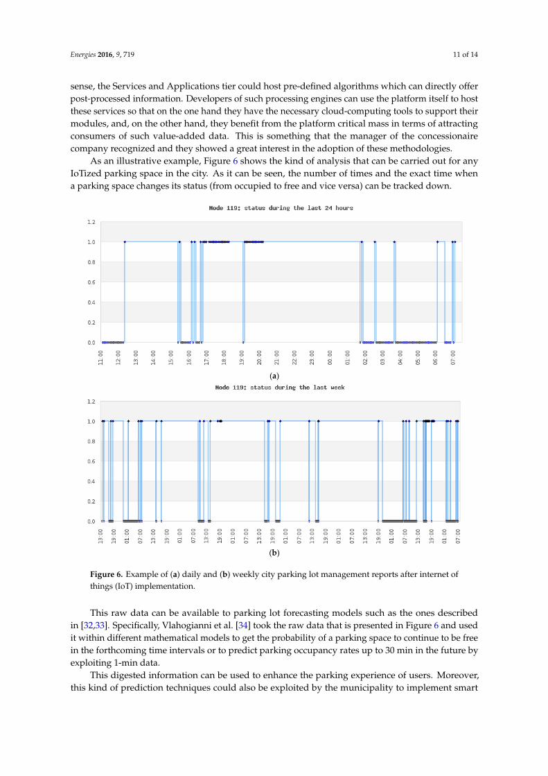
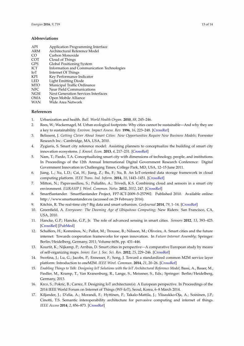
As an illustrative example, Figure 6 shows the kind of analysis that can be carried out for anyIoTized parking space in the city. As it can be seen, the number of times and the exact time whena parking space changes its status (from occupied to free and vice versa) can be tracked down.Energies 2016, 9, 719 11 of 14
(a)
(b)
Figure 6. Example of (a) daily and (b) weekly city parking lot management reports after internet of
things (IoT) implementation.
This raw data can be available to parking lot forecasting models such as the ones described in
[32,33]. Specifically, Vlahogianni et al. [34] took the raw data that is presented in Figure 6 and used it
within different mathematical models to get the probability of a parking space to continue to be free
in the forthcoming time intervals or to predict parking occupancy rates up to 30 min in the future by
exploiting 1-min data.
This digested information can be used to enhance the parking experience of users. Moreover,
this kind of prediction techniques could also be exploited by the municipality to implement smart
policies on the parking spaces of the city and integrate this knowledge into a holistic management of
the city traffic.
5. Conclusions
This paper presents a field-trial case based on the smart parking application and service which
were developed and run on top of a cloud and IoT-based smart city platform. Moreover, the paper
introduces the high-level architecture for this platform. It addresses key smart city paradigm
requirements and enables the development of added-value services, like the one introduced in the
article, by integrating in its design, concepts of IoT, and cloud technologies.
This work shows that the value of IoT infrastructures is only leveraged by the ability to virtualize
the underlying complexity through well-defined interfaces and enablers that enable easy
development and instantiation of services and applications that makes use of the data generated and
accesses the actuation capabilities of the myriad of devices that coexist in the smart city ecosystem.
Figure 6. Example of (a) daily and (b) weekly city parking lot management reports after internet ofthings (IoT) implementation.
This raw data can be available to parking lot forecasting models such as the ones describedin [32,33]. Specifically, Vlahogianni et al. [34] took the raw data that is presented in Figure 6 and usedit within different mathematical models to get the probability of a parking space to continue to be freein the forthcoming time intervals or to predict parking occupancy rates up to 30 min in the future byexploiting 1-min data.
This digested information can be used to enhance the parking experience of users. Moreover,this kind of prediction techniques could also be exploited by the municipality to implement smart
Energies 2016, 9, 719 12 of 14
policies on the parking spaces of the city and integrate this knowledge into a holistic management ofthe city traffic.
5. Conclusions
This paper presents a field-trial case based on the smart parking application and service whichwere developed and run on top of a cloud and IoT-based smart city platform. Moreover, the paperintroduces the high-level architecture for this platform. It addresses key smart city paradigmrequirements and enables the development of added-value services, like the one introduced in thearticle, by integrating in its design, concepts of IoT, and cloud technologies.
This work shows that the value of IoT infrastructures is only leveraged by the ability to virtualizethe underlying complexity through well-defined interfaces and enablers that enable easy developmentand instantiation of services and applications that makes use of the data generated and accesses theactuation capabilities of the myriad of devices that coexist in the smart city ecosystem. Additionally,by implementing a smart solution for one of the most demanded smart city service, namely parking,in this work it has been possible to carry out an assessment of the benefits that the wide-scaleintroduction of this kind of solutions can bring to the cities of the future.
In conclusion, this paper provides a review of the implementation and assessment of a prototypesmart parking service supported by real-world large-scale IoT infrastructure and the results showedthat this kind of service can bring important benefits in the efficiency of currently run services.No detailed analysis of the impact of the solution is provided since the contribution of the paper isto present how a holistic ICT-based platform is able to support the development and deploymentof smart services in a real city environment. Particularly, through the actual implementation anddeployment of a smart parking use case in a real-world scenario. The integrated approach introducedin this work would serve as a proof-of-concept for development of novel smart city services in thenear future tacking additional services linked to efficient use of renewable energies, electrical mobility,and gamification and rewarding mechanisms.
In addition to the direct feedback that is provided to the drivers through the installed panelsor mobile devices (e.g., smartphone or GPS receiver) as described in this article, having access tothis information and being able to correlate it with other existing datasets in a homogeneous wayenable further extension of the smart parking case to a more holistic smart city traffic management usecase that provides intelligent transportation services such as multi-modal routing and location-basedinformation to mobile and Web users. Future work encompasses the development of a service toallow users to make smarter travel choices to get to their destinations, reducing the time spent drivingthrough the streets and avoiding, as much as possible, congestion and occasional incidents on thestreets. This will be achieved providing users with reliable, real-time information on the traffic situationthroughout the city. A system of models including a flow estimation model, a traffic assignment modeland a parking dynamics model fed by the traffic and parking status data provided by the smart cityplatform will generate the situation on top of which smart decisions can be made.
Acknowledgments: This work has been partially funded by the research project SmartSantander,under FP7-ICT-2009-5 of the 7th Framework Programme of the European Community. This work has beensupported by the Spanish government (Ministerio de Economía y Competitividad, Fondo Europeo de DesarrolloRegional, FEDER) by means of the project ADVICE “Dynamic provisioning of connectivity in high density 5Gwireless scenarios” (TEC2015-71329-C2-1-R).
Author Contributions: The work presented in this paper is a collaborative development by all of theauthors. In particular, Jorge Lanza, Luis Sanchez, and Luis Muñoz have made the specification of the system.Veronica Gutierrez has developed the smart parking applications and Pablo Sotres is the main developer of thesmart city platform. Jose Antonio Galache and Jose Ramon Santana conducted the assessment of the field trial andwere responsible of the deployment and management of the physical infrastructure used. Writing of the paperwas shared between the authors.
Conflicts of Interest: The authors declare no conflict of interest.
Energies 2016, 9, 719 13 of 14
Abbreviations
API Application Programming InterfaceARM Architectural Reference ModelCO Carbon MonoxideCOT Cloud of ThingsGPS Global Positioning SystemICT Information and Communication TechnologiesIoT Internet Of ThingsKPI Key Performance IndicatorLED Light Emitting DiodeMTO Municipal Traffic OrdinanceNFC Near Field CommunicationsNGSI Next Generation Services InterfacesOMA Open Mobile AllianceWAN Wide Area Network
References
1. Urbanization and health. Bull. World Health Organ. 2010, 88, 245–246.2. Rees, W.; Wackernagel, M. Urban ecological footprints: Why cities cannot be sustainable—And why they are
a key to sustainability. Environ. Impact Assess. Rev. 1996, 16, 223–248. [CrossRef]3. Belissent, J. Getting Clever About Smart Cities: New Opportunities Require New Business Models; Forrester
Research Inc.: Cambridge, MA, USA, 2010.4. Zygiaris, S. Smart city reference model: Assisting planners to conceptualize the building of smart city
innovation ecosystems. J. Knowl. Econ. 2013, 4, 217–231. [CrossRef]5. Nam, T.; Pardo, T.A. Conceptualizing smart city with dimensions of technology, people, and institutions.
In Proceedings of the 12th Annual International Digital Government Research Conference: DigitalGovernment Innovation in Challenging Times, College Park, MD, USA, 12–15 June 2011.
6. Jiang, L.; Xu, L.D.; Cai, H.; Jiang, Z.; Bu, F.; Xu, B. An IoT-oriented data storage framework in cloudcomputing platform. IEEE Trans. Ind. Inform. 2014, 10, 1443–1451. [CrossRef]
7. Mitton, N.; Papavassiliou, S.; Puliafito, A.; Trivedi, K.S. Combining cloud and sensors in a smart cityenvironment. EURASIP J. Wirel. Commun. Netw. 2012, 2012, 247. [CrossRef]
8. SmartSantander. SmartSantander Project, FP7-ICT-2009–5-257992. Published 2010. Available online:http://www.smartsantander.eu (accessed on 29 February 2016).
9. Kitchin, R. The real-time city? Big data and smart urbanism. GeoJournal 2014, 79, 1–14. [CrossRef]10. Greenfield, A. Everyware: The Dawning Age of Ubiquitous Computing; New Riders: San Francisco, CA,
USA, 2010.11. Hancke, G.P.; Hancke, G.P., Jr. The role of advanced sensing in smart cities. Sensors 2012, 13, 393–425.
[CrossRef] [PubMed]12. Schaffers, H.; Komninos, N.; Pallot, M.; Trousse, B.; Nilsson, M.; Oliveira, A. Smart cities and the future
internet: Towards cooperation frameworks for open innovation. In Future Internet Assembly; Springer:Berlin/Heidelberg, Germany, 2011; Volume 6656, pp. 431–446.
13. Kourtit, K.; Nijkamp, P.; Arribas, D. Smart cities in perspective—A comparative European study by meansof self-organizing maps. Innov. Eur. J. Soc. Sci. Res. 2012, 25, 229–246. [CrossRef]
14. Swetina, J.; Lu, G.; Jacobs, P.; Ennesser, F.; Song, J. Toward a standardized common M2M service layerplatform: Introduction to oneM2M. IEEE Wirel. Commun. 2014, 21, 20–26. [CrossRef]
15. Enabling Things to Talk: Designing IoT Solutions with the IoT Architectural Reference Model; Bassi, A., Bauer, M.,Fiedler, M., Kramp, T., Van Kranenburg, R., Lange, S., Meissner, S., Eds.; Springer: Berlin/Heidelberg,Germany, 2013.
16. Krco, S.; Pokric, B.; Carrez, F. Designing IoT architecture(s): A European perspective. In Proceedings of the2014 IEEE World Forum on Internet of Things (WF-IoT), Seoul, Korea, 6–8 March 2014.
17. Kiljander, J.; D’elia, A.; Morandi, F.; Hyttinen, P.; Takalo-Mattila, J.; Ylisaukko-Oja, A.; Soininen, J.P.;Cinotti, T.S. Semantic interoperability architecture for pervasive computing and internet of things.IEEE Access 2014, 2, 856–873. [CrossRef]

Energies 2016, 9, 719 14 of 14
18. Petrolo, R.; Loscri, V.; Mitton, N. Towards a cloud of things smart city. IEEE COMSOC MMTC E Lett.2014, 9, 44–47.
19. Vögler, M.; Schleicher, J.M.; Inzinger, C.; Dustdar, S.; Ranjan, R. Migrating Smart City Applications to theCloud. IEEE Cloud Comput. 2016, 3, 72–79. [CrossRef]
20. Ji, Z.; Ganchev, I.; O’Droma, M.; Zhao, L.; Zhang, X. A cloud-based car parking middleware for IoT-basedsmart cities: Design and implementation. Sensors 2014, 14, 22372–22393. [CrossRef] [PubMed]
21. Bakıcı, T.; Almirall, E.; Wareham, J. A smart city initiative: The case of Barcelona. J. Knowl. Econ. 2013, 4,135–148. [CrossRef]
22. Ojala, T.; Kukka, H.; Lindén, T.; Heikkinen, T.; Jurmu, M.; Hosio, S.; Kruger, F. UBI-hotspot 1.0: Large-scalelong-term deployment of interactive public displays in a city center. In Proceedings of the 2010 FifthInternational Conference on Internet and Web Applications and Services (ICIW), Barcelona, Spain,9–15 May 2010.
23. Gil-Castineira, F.; Costa-Montenegro, E.; Gonzalez-Castano, F.J.; López-Bravo, C.; Ojala, T.; Bose, R.Experiences inside the ubiquitous Oulu smart city. Computer 2011, 44, 48–55. [CrossRef]
24. Strickland, E. Cisco bets on South Korean smart city. IEEE Spectr. 2011, 48, 11–12. [CrossRef]25. Carvalho, L.; Campos, J.B. Developing the PlanIT Valley: A view on the governance and societal embedding
of u-eco city pilots. Int. J. Knowl.-Based Dev. 2013, 4, 109–125. [CrossRef]26. Panasonic, Fujisawa Sustainable Smart Town. Available online: http://panasonic.net/es/fujisawasst/
(accessed on 17 May 2016).27. Carillo-Aparicio, S.; Heredia-Larrubia, J.R.; Perez-Hidalgo, F. SmartCity Málaga, a real-living lab and its
adaptation to electric vehicles in cities. Energy Policy 2013, 62, 774–779. [CrossRef]28. Sanchez, L.; Muñoz, L.; Galache, J.A.; Sotres, P.; Santana, J.R.; Gutierrez, V.; Ramdhany, R.; Gluahk, A.;
Krco, S.; Theodoridis, E.; et al. SmartSantander: IoT experimentation over a smart city testbed. Comput. Netw.2014, 61, 217–238. [CrossRef]
29. Lanza, J.; Sánchez, L.; Muñoz, L.; Galache, J.A.; Sotres, P.; Santana, J.R.; Gutiérrez, V. Large-Scale mobilesensing enabled internet-of-things testbed for smart city services. Int. J. Distrib. Sens. Netw. 2015, 2015, 157.[CrossRef]
30. Wang, W.; De, S.; Toenjes, R.; Reetz, E.; Moessner, K. A comprehensive ontology for knowledge representationin the internet of things. In Proceedings of the 2012 IEEE 11th International Conference on Trust, Securityand Privacy in Computing and Communications (TrustCom), Liverpool, UK, 25–27 June 2012.
31. Kotis, K.; Katasonov, A. Semantic interoperability on the web of things: The semantic smart gatewayframework. In Proceedings of the 2012 6th International Conference on the Complex, Intelligent andSoftware Intensive Systems (CISIS), Palermo, Italy, 4–6 July 2012.
32. Caicedo, F.; Blazquez, C.; Miranda, P. Prediction of parking space availability in real time. Expert Syst. Appl.2012, 39, 7281–7290. [CrossRef]
33. Olusina, J.O.; Desalu, T. Prediction of parking lot availability using Elang’s loss model. Int. J. Eng.2014, 5, 63–70.
34. Vlahogianni, E.I.; Kepaptsoglou, K.; Tsetsos, V.; Karlaftis, M.G. A real-time parking prediction system forsmart cities. J. Intell. Transp. Syst. 2016, 20, 192–204. [CrossRef]
© 2016 by the authors; licensee MDPI, Basel, Switzerland. This article is an open accessarticle distributed under the terms and conditions of the Creative Commons Attribution(CC-BY) license (http://creativecommons.org/licenses/by/4.0/).