slope stability assessment in and around taiz city, yemen ... · petrologi-cally tr1 is represented...
TRANSCRIPT

Available onlinewww.ejaet.com
European Journal of Advances in Engineering and Technology, 2018, 5(1): 8-17
Research Article ISSN: 2394 - 658X
8
Slope Stability Assessment in and around Taiz City, Yemen, Using
Landslide Possibility Index (LPI)
Janardhana M.R.1 and Abdul-Aleam Ahmed A.D. Al-Qadhi2
1Department of Geology, Yuvaraja’s College, University of Mysore, Mysuru, India 2Department of Geology, Applied Science College, University of Taiz, Taiz, Yemen
_____________________________________________________________________________________________
ABSTRACT
Every nation strives hard to achieve economic development for which adequate infrastructure is required to ac-
complish the desired goals. In mountainous terrain, road and highway networks play an important role for trans-
portation, public conveyance and other socio-economic activities. Infrastructure development in hilly areas war-
rants excavations for the construction or road widening purpose undermining the stability of the slopes. The un-
planned excavations of Tertiary rock slopes for construction and/or widening purposes before the political unrest
in and around Taiz city have caused the instability of the slopes and thus threatened the very purpose of achieving
the economic development. In the present work, evaluation of the stability of 12 rock slopes along road cuts and
natural outcrops in and around Taiz city was carried out, employing the Landslide Possibility Index (LPI) system.
The results showed that the possibility of failures and the degree of hazard in one rock slope location (No.25) is
'Moderate’, while in the eight rock slope locations (Nos. 15, 16, 17, 20, 22, 23, 24 and 26) are 'High’. The possi-
bility of failure in the slope location Nos. 18 and 19 are 'Very High’ while in the location No. 21 is 'Low’. The
areas of 'Moderate Hazard’ are represented by granite and jointed rhyolite /dacite rocks while the slopes of ‘High
Hazard’ are represented by different lithologies. The remedial measures for 12 slope locations are suggested
based on the degree of possibility of failure and field observations. The intensive field studies indicate that the var-
ious causal factors in addition to rainfall have a bearing on causing the instability along the rock slopes of the
study area.
Keywords: Taiz city in Yemen, Slope stability, Possibility of failure, Landslide Possibility Index
_____________________________________________________________________________________________
INTRODUCTION
Rock slope failure along roads, highways, railways and in urban and industrial areas is one of the geologic hazards
that will destroy engineering projects such as dams, buildings, roads and railroads [1]. In urban areas such as Taiz
city, rapid development of buildings and other infrastructure facilities have caused unfavourable changes in the con-
figuration of Tertiary rock slopes causing instability to the building foundations and development of cracks on their
walls, in addition to damages of roads and the local traffic and to obstruct the traffic for several hours. Foundation
problems triggered the collapse of the buildings and landslides [2]. These incidences made impacts on the socio-
economy and brought undesirable changes in the lives of the citizens. For these reasons, the slope stability evalua-
tion of rocks is vital for the assessment and designing safety measures for excavated slopes, and/or the equilibrium
conditions of a natural slope.
There are different geomechanical classification systems proposed by many researchers for the evaluation of the
rock slope stability such as rock mass rating (RMR, Bieniawski [3-4]), rock mass strength (RMS, Selby[5- 6], Moon
and Selby [7], slope mass rating (SMR, Romana[8], slope rock mass rating (SRMR, Robertson [9], modified min-
ing rock mass rating (MRMR, Haines and Terbrugge [10], natural slope methodology (NSM, Shuk [11], Chinese
slope mass rating (CSMR, Chen [12]), modified rock mass rating (M-RMR, Ünal [13], Rock slope Deterioration
Assessment (RDA, Nicholson and Hencher [14], Nicholson et al[15], Nicholson [16-18]), slope stability probability
classification (SSPC, Hack [19], Hack et al [20]), modified slope stability probability classification (SSPC, Lind-
say et al [21]), Volcanic Rock Face Safety Rating (VRFSR, Singh and Connolly [22], continuous rock mass rating
(Sen and Sadagah [23], Tomás et al [24]), Slope stability rating system (SSR, Taheri and Tani [25-26]) and the

Janardhana et al Euro. J. Adv. Engg. Tech., 2018, 5(1):8-17
______________________________________________________________________________
9
alternative rock mass classification system proposed by Pantelidis [27], Fuzzy Slope Mass Rating (FSMR, Daftari-
besheli et al [28]), New Slope Mass Rating (NSMR, Singh et al [29]).
These rock mass classification systems are based on the assessment of rock mass in the field and determination of
selected mechanical properties in the laboratory. Due to the increasing cost of site investigations and geotechnical
work, other methods were adopted for the evaluation of slope stability against landslide hazards including the de-
termination of Geological Strength Index (GSI, introduced by Hoek [30], and modified by Hoek et al [31], Hoek and
Brown [32], Marinos and Hoek [33], Marinos [34]) and Landslide Possibility Index (LPI) system suggested by Be-
jerman [35]). These two systems/indices are basically based on simple field observations of the rock mass.
In the present work, twelve slope locations along road cuts and natural outcrops in and around Taiz city have been
studied to evaluate their stability, employing the Landslide Possibility Index (LPI) system [35]. This system is
adopted because of its simplicity, effectiveness and to infer the actual field conditions.
STUDY AREA
Taiz city is located in the middle of the Central Highlands of Yemen, in the watershed area of upper Wadi Rasyan,
mainly at the foot hill and slope regions of Sabir mountain and bound by the latitudes, 13° 31' 49’ and 13° 44' 29’ N,
and longitudes, 43° 54' 17’ and 44° 09' 04’ E (Fig. 1).Topographically, the study area is well represented by moun-
tains, isolated hills, steep slopes, undulating eroded lands with major Wadis, and plains and loess covered plateau
(Al-Janad Plateau) with levels ranging from about 800 m to 3000 m above mean sea level. These features make the
rock slopes in Taiz city and its surrounding areas vulnerable for landslide hazards that threaten the lives and proper-
ties of the people living in the area. Hydrologically, the annual rainfall in the investigated area is bimodal, the first
season extends from April to June with peak in May and the second season is from August to October with peak in
September. During the month July, there is less rainfall while the dry months begin in mid-October and end in mid-
March. Rainfall record obtained from three rain gauge stations (Ussayfra/79-03, NWRA/ 98-04 and Taiz airport/76-
79 & 83-89) located in and around Taiz city reveal that the average annual rainfall in the study area is about 520
mm. During the rainfall periods, the meteoric water flows from high lands over steep slopes into natural flow chan-
nels which are in most cases are connected together forming the Wadis. Several intermittent Wadis pass through the
city of Taiz and/or in its vicinity. The principal Wadis are, Wadi Al- Hawban, Wadi Al-Lasab, Wadi Hasanat, Wadi
Salah, Wadi Kalabah, Wadi Al-Qadhi, Wadi Al-Madam and Wadi Mouasal. Water discharged through these Wadis
form the major tributaries of Wadi Rasyan and join Red Sea [36].
GEOLOGICAL SETTING
The major geological units and their distributions in the investigated area are shown in the geological map (Fig.2).
The Tertiary bimodal volcanic materials are represented by alternating sequences of volcanic lava flows and volcan-
iclastic deposits of variable composition ranging from the mafic to the silicic types. These sequences of volcanic
lava flows and volcaniclastic deposits were erupted in five phases [37-39] and in a repeated manner. From bottom
to top, the sequence is made up of the following (Fig.2):
1) Tertiary lower mafic sequence phase (Tb1, Eocene): Tb1 is represented by dark grey (in fresh surface) to choco-
late brown or dark reddish brown (on outer weathered/altered surface) jointed/ massive basaltic lava flows which
are associated with basaltic volcaniclastic materials. Often the jointed basaltic lava flows are interbedded
/alternated with basaltic volcaniclastic materials. They are affected by different types of discontinuities most of
them are irregular and columnar joints of thermal origin in addition to other discontinuities. The rock blocks
formed by these joints vary in their sizes and shapes such as columnar, polyhedral, tabular, prismatic and rhombo-
hedral blocks. It forms scarps and highly dissected mountain relief.
2) Tertiary lower silicic sequence phase (Tr1, Eocene -Oligocene): It forms plateaus and rarely small hills. Petrologi-
cally Tr1 is represented by jointed rhyolites /dacites, ignimbrites, rhyolitic tuffs, lapillistones volcaniclastic brecci-
as, and random pumice and obsidian [40]. The higher amounts of volcaniclastic rocks in Tr1 sequence indicate that
initially volcanism of silicic volcanic rocks was more explosive [39]. This sequence shows vertically change in li-
thology and colonnade columnar jointing features.
3) Tertiary middle mafic sequence phase (Tb2, Oligocene-Miocene): Tb2 is represented by the basaltic lava flows
and volcaniclastic deposits extruded primarily through the feeders’ like- dykes. Volcaniclastic deposits are classi-
fied into tuff-breccias, lapilli-tuffs, agglomerates and lapillistones based on their particles sizes [40]. In the study
area, the rocks and deposits of Tb2 have a greatest areal extent relative to all other units with a thickness reaching
up to 100 m, and covering an area of 39.61 % of total area. These lava flows have different physical characteristics
(colour, heterogeneity, discontinuity, thickness, horizontal attitude, weathering/alteration, intercalation and repeti-
tion with depth) in both vertical and horizontal directions implying variation in eruption type, mode of transport,

Janardhana et al Euro. J. Adv. Engg. Tech., 2018, 5(1):8-17
______________________________________________________________________________
10
distance travelled from the vent, temperature of the deposits, particle size, water content and paleorelief of older
Tr1 sequence [40].
4) Tertiary upper silicic sequence phase (Tr2, Oligocene-Miocene): The outcrops of Tr2 sequence are limited in
extent and are restricted to E-W trending Sabir fault system. They constitute isolated domal mountains and plugs of
different sizes and shapes. It covers an area of 41.47 sq.km of the total area (10. 6%).Tr2 is represented by fine-
grained, porphyritic, yellow to gray, white, red, green and pink jointed/massive rhyolites/dacites and/or varicolored
volcaniclastics of rhyolitic composition. Pitchstone is also observed in different locations as lava flows or as irregu-
lar bodies intercalated with volcaniclastic materials. Al-Qadhi et al [40] classified the volcaniclastic materials of the
study area into rhyolitic tuffs, rhyolitic lapilli-tuffs and rhyolitic lapillistones based on the particle sizes. The most
characteristic feature of Tr2 is its occurrence as alternating sequence of more than one lava flow with lateral and
vertical variations even in the same location, for the same reasons as mentioned in Tb2.Tertiary Sabir granitic plu-
ton, emplaced as laccolithic body inside the older stratified Tertiary Yemen volcanic rocks forms the dominant mor-
phological feature named Sabir Mountain, overlooking the city of Taiz in the southern part of the study area (Fig.2).
It is characterized by high lands, steep slopes and deep valleys. Physical weathering of varying intensities has pro-
duced different sizes of granitic blocks and boulders along the slope sides. Granite shows white to greyish white
colour, massive, medium to coarse-grained grading up to granite porphyry and contains almost < 5 % of dark col-
oured minerals. They belong to the alkaline or peralkaline suite of A-type granites [41]. These are produced by frac-
tional crystallization in the basic magmas [42, 43]. All the rock units are faulted and sheared to varying degrees, and
they have been subjected to different levels of weathering/ alteration and erosion.
Fig.1 Location map of the study area
LANDSLIDES IN AND AROUND TAIZ CITY
From the recent landslides and collapsing of houses and other facilities in the study area, it is inferred that this phe-
nomenon may become more hazardous in the future, especially where the rapid development of civic amenities and
other infrastructure facilities are causing unfavorable changes in the configuration of Tertiary rock slopes. Taiz city
is densely populated and three recently laid important highways viz., Taiz-Sana’a, Taiz –Hodeidah and Taiz-Aden in
addition to the internal road networks run through the mountains, hills and plains composed of diversified Tertiary
rock materials such as basalt, rhyolite/dacite, volcaniclastics and granite.As a result of the newly laid roads which
involved the rock cuts along the slopes, the slopes have become unsTable -posing danger to the vehicular traffic as
well as the other properties such as the houses built on or near the slopes. The study area has witnessed landslides
and consequent damages especially during the rainfall periods.A number of buildings have been damaged by cata-
strophic landslides, such as Jabal Amid Al-Habil, Jabal Al-Mahjoor Kalabah, Jabal Al-Abiad Wadi Al-Qadhi, Jabal
Al-Kahirah Castle etc.
The locations of all recorded landslides are shown on the geological map (Fig.2) of the study area. In-depth studies
carried out by the present investigators brought to light the following factors for most of the incidences of landslides
in the study area:

Janardhana et al Euro. J. Adv. Engg. Tech., 2018, 5(1):8-17
______________________________________________________________________________
11
a) ‘Poor’ to ‘Fair’ quality of the rock mass of the slope which is composed of jointed acid/basic lava flows alternat-
ed/intercalated with varicolored volcaniclastic of basaltic/rhyolitic composition.
b) Presence of weak volcaniclastic layers with poor geotechnical properties such as low density, high porosity, low
strength, low capacity, high plasticity, etc., at the bottom parts of the slopes [2].
c) Overhanging of the upper jointed lava flows (basalt/rhyolite) which often have discontinuities with unfavourable
orientation.
d) Poor drainage conditions of slope
e) The area has semiarid climatic conditions (about 520 mm/yr).
Fig. 2 Geological map of the study area (modified after [44, 38, 39, 40]) with locations of the landslides and LPI
METHODS AND MATERIALS
The rock masses of the slopes investigated comprise of Tertiary bimodal volcanic materials and their associated in-
trusive bodies. Site investigations were carried out on exposures along road cuts and on the natural rock outcrops at
110 locations, 12 of them representing various lithological and geotechnical conditions in and around Taiz city (Ta-
ble -1 and Fig. 2) were selected as rock slope stations. The stability of the investigated slopes was evaluated using
the LPI. The LPI system involves the study of ten main characteristic features encompassing geological, structural,
hydrological and geomorphological conditions of the given area.

Janardhana et al Euro. J. Adv. Engg. Tech., 2018, 5(1):8-17
______________________________________________________________________________
12
Table --1 Location and Lithologies of the Investigated Slope Stations in the Study Area
Slope St. No.
Location of slope St. (UTM) Lithology
X Y
28 402904 1506821 Volcaniclastic rocks
35 396829 1502984 Volcaniclastic rocks
38 390417 1505056 Co-Rhyolite
54b 402635 1501211 Co. rhyolite
78 393755 1498977 Granite
87 391429 1499513 Granite
88 391739 1498833 Granite
104 399781 1512145 J. rhyolite
105 393299 1503211 J. basalt
109 389291 1501146 Co. rhyolite
110 396549 1500899 Co. rhyolite/dacite
100 397281 1500393 J. rhyolite
J: Jointed; Co.: Columnar.
Table --2 Landslide Possibility Index (LPI) Calculation (after Bejerman [35])
The parameters are:
Each feature has a range of values (Table --2). The value of each feature is estimated and quantified in the field as
per the procedure prescribed by Bejerman [35]. Estimated values of 10 parameters are added to determine the Land-
slide Possibility Index (LPI) value for the slope as shown in the following equation:
1.Slope height 6.Spacing of the discontinuities
2.Slope angle 7.Orientation of the discontinuities
3.Grade of fracture of the rock mass 8.Vegetation cover
4.Grade of weathering of the rock mass 9.Water infiltration
5.Gradient of the discontinuities 10.Previous landslides

Janardhana et al Euro. J. Adv. Engg. Tech., 2018, 5(1):8-17
______________________________________________________________________________
13
LPI= (𝐞𝐬𝐭𝐢𝐦𝐚𝐭𝐞𝐝 𝐯𝐚𝐥𝐮𝐞𝟏𝟎
𝐢=𝟏𝐬) = 𝟏+ 𝟐+ 𝟑+ 𝟒 ± 𝟓 + 𝟔 + 𝟕+ 𝟖+ 𝟗+ 𝟏𝟎.
If the orientation of the discontinuities is favorable, the estimated value of the discontinuity gradient is subtracted
from the total LPI for the purpose of correcting the LPI value. The degree of the hazard of the slope is determined
based on the LPI value i.e., the sum of ten estimations (Table -2). Accordingly, the possibilities of failures of slopes
were classified into six categories as listed in the Table -3 [35]. These are: I (small) (when LPI=2-5), II (very low)
(when LPI=6-10), III (low) (when LPI= 11-15), IV (moderate) (when LPI 16-20), V (high) (when LPI=21-25) and
VI (very high) (when LPI >25). Also, based on the defined LPI category for each rock slope, the landslide hazard of
the rock slope can be evaluated. Three hazard categories were considered by Bejerman [45] as shown in the Table-4.
RESULTS AND DISCUSSION
LPI values of the investigated slopes are provided in Table -5. The degree of hazard and failure possibility for all the
investigated slope locations in different lithologies is shown in Figure 3. The computed values of LPI at slope loca-
tions 18 and 19 are 27 and 26.5 respectively indicating that the possibility of failure along these slopes is ‘Very
High’and the degree of hazard is’High’. These slopes are characterized by steep gradient, intensively fractured and
weathered rocks, and unfavourable orientation of discontinuities. Figure 3 is example for Very high hazard slopes.
The suggested remedial measures for the stability of these slopes are provided in Table -5.
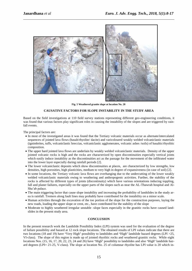
The LPI values for the rock slopes at location Nos.15, 16,17,20, 22, 23, 24 and 26 are 24, 21, 21, 22.5, 23, 23, 22
and 22.5 respectively that indicate the possibility of failure and the degree of hazard along these slopes are ‘High’
(Table -5). From the landslide inventory and field observations, maximum numbers of incidences of landslides have
been recorded along these slopes. The average heights and dips of these slopes range from 2.3 m to 14.5m and from
56 to more than 90° (overhanging) respectively. Almost all these slopes (except slopes of granite) are divisible into
two parts, upper and lower parts. The upper parts of these slopes consist of brown to yellowish brown coloured,
slight to highly weathered jointed rhyolite/dacite or light reddish brown coloured, pyroclastic textured, slightly
weathered, moderately weak huge blocks of volcanic lapilli-tuff of various dimensions. The lower parts are formed
from moderate to highly weathered, unconsolidated to semi-consolidated volcaniclastic deposits or volcanic ash
(volcanic soil) with different thickness. The upper jointed rhyolite/dacite or lapilli-tuff rock masses are cut by three
or four main joint sets in addition to randomly oriented joints. The average spacing of these main joint sets range
from 0.04m to 3m. Figure 5 depicts an example for high hazard slopes.
Table -4 Landslide Hazard Categories, according to LPI categories (after
Bejerman [45])
LPI Category Hazard Category
I- II (1-10) Low
III-IV (11-20) Moderate
V-VI >21 High
Table -3 Failure Category for Each LPI Category (after Bejerman [35])
LPI Category Failure Possibility LPI
(I) Small (0-5)
(II) Very Low (6-10)
(III) Low (11-15)
(IV) Moderate (16-20)
(V) High and (21-25)
(VI) Very High (>25)
Fig. 3 LPI values and slope categories (after Al-Qadhi [46])

Janardhana et al Euro. J. Adv. Engg. Tech., 2018, 5(1):8-17
______________________________________________________________________________
14
Table -5 Computed LPI values for the investigated rock slopes (12 locations) in and around Taiz city, Yemen (after Al-Qadhi, 2017)
M: Moderate, H: High, V.H: Very High, L: Low1: Volcaniclastic rocks, 2: Jointed/columnar rhyolite/dacite rocks, 3:Granite rocks, 4:Jointed/ columnar basalt rocks, 5: Big boulders and cobbles of rhyolitic rocks, *: Suggested remedial measures based on Failure possibility (Romana,1985) and field observations
No. Characteristic features of the slope
Rock slope stations
(locations)
281
(15) 351
(16) 382
(17) 54b2
(18) 783
(19) 873
(20) 883
(21) 1005
(22) 1042
(23) 1054
(24) 1092 (25)
1102
(26)
1 Slope Height 1 2 1 4 5 1 2 2 1 1 1 1
2 Slope angle 4 4 4 4 4 4 4 3 4 4 4 4
3 Grade of fracture of the rock mass 2 0 1 1.5 1 1 1 1 1 1.5 1 2
4 Grade of weathering of the rock mass 2.5 1 0 2.5 1.5 2.5 0 2.5 2.5 1.5 0.5 1.5
5 Gradient of the discontinuities + 4 + 4 + 4 + 4 + 4 + 3 -3 + 4 + 4 + 4 + 3.5 + 4
6 Spacing of the discontinuities 2.5 1 1 2 2 2 2 1.5 2 2 2 2
7 Orientation of the discontinuities 4 4 4 4 4 4 4 4 4 4 4 4
8 Vegetation cover 0 0 1 0 1 0 0 0 0 0 0 0
9 Water infiltration 3 3 3 3 3 3 3 3 3 3 3 3
10 Previous landslides 1 2 2 2 1 2 2 2 1.5 1 1 1
Landslide Possibility Index (LPI) 24 21 21 27 26.5 22.5 15 23 23 22 20 22.5
LPI category V V V VI VI V III V V V IV V
Failure possibility H H H V.H V.H H L H H H M H
Hazard category H H H H H H M H H H M H
Suggested remedial measures* (b) (c) (c) (b) (g) (b) (f) (a) (a) (a) (d) (e)
(a): Removing all unstable or potentially unstable rock blocks from upper part of the slope (head) and erection of gravity retaining wall along with drainage holes at slope toe
(b): Scaling and trimming of the upper portion of slope and erection of gravity retaining wall along with drainage holes at slope toe.
(c): Removing all unstable or potentially unstable rock blocks from upper part of the slope (head) and plant roots
(d): Scaling and trimming of the upper portions of the slope
(e): Erection of gravity retaining wall along with drainage holes at slope toe and use the surface drainage methods
(f): Removing all unstable or potentially unstable rock blocks from upper part of the slope (head) and construction of toe ditches.
(g): Removing all unstable or potentially unstable rock blocks from some parts of the slope and stabilization of the other parts by routing with cement. In
cast the unstable steep slope is inaccessible, the avoiding the construction of housings at slope toe is preferable.
LPI value for slope location no. 25 is 20 implying the possibility of failure and the degree of hazard of this slope
belong to the class’Moderate’ (Table -5), while at slope location no. 21, the possibility of failure and the degree of
hazard are ‘Moderate to Low’. The LPI values for jointed/columnar rhyolite/ dacite slopes vary from 20 to 27 while
for the granitic slopes are from 15 to 26.5 indicating that these slopes have ‘High to Very High’ and ‘Low to Very
High’ failure possibilities respectively (Table -5). Remedial measures required to thwart the incidences of slope fail-
ures and landslides for all the investigated slopes are provided in Table -5. These remedial measures have been sug-
gested based on the possibility of failure [8] and field observations.
Fig. 4 Jointed rhyolite slope at location No. 18.
Janardhana et al Euro. J. Adv. Engg. Tech., 2018, 5(1):8-17
______________________________________________________________________________
15
Fig. 5 Weathered granite slope at location No. 20
CAUSATIVE FACTORS FOR SLOPE INSTABILITY IN THE STUDY AREA
Based on the field investigations at 110 field survey stations representing different geo-engineering conditions, it
was found that various factors play significant roles in causing the instability of the slopes and are triggered by rain-
fall events.
The principal factors are:
In most of the investigated areas it was found that the Tertiary volcanic materials occur as alternate/intercalated
sequences of jointed lava flows (basalt/rhyolite/ dacite) and varicoloured weakly welded volcaniclastic materials
(ignimbrites, tuffs, volcaniclastic breccias, volcaniclastic agglomerates, volcanic ashes /soils) of basaltic/rhyolitic
composition.
The upper hard jointed lava flows are underlain by weakly welded volcaniclastic materials. Density of the upper
jointed volcanic rocks is high and the rocks are characterized by open discontinuities especially vertical joints
which easily induce instability as the discontinuities act as the passage for the movement of the infiltrated water
into the lower layer especially during rainfall periods [2].
The lower volcaniclastic deposits which show discontinuities at places, are characterized by low strengths, low
densities, high porosities, high plasticities, medium to very high in degree of expansiveness (in case of soil) [2].
In some locations, the Tertiary volcanic lava flows are overhanging due to the undercutting of the lower weakly
welded volcaniclastic materials owing to weathering and anthropogenic activities. Further, the stability of the
rocks is affected by different types of joints (discontinuity) which have various orientations inducing toppling,
fall and planer failures, especially on the upper parts of the slopes such as near the AL-Thawrah hospital and Al-
Sha’ab palace.
The main triggering factor that cause slope instability and increasing the probability of landslides in the study ar-
ea is rainfall. Tremors along fault lines may probably have contributed for the instability on a minor scale.
Human activities through the excavation of the toe portion of the slope for the construction purposes, laying the
new roads, loading the upper slope or crest, etc., have contributed for the stability of the slope
Moderate to highly weathered irregular unstable -slope faces especially in the granitic rocks have caused land-
slides in the present study area.
CONCLUSION
In the present research work the Landslide Possibility Index (LPI) system was used for the evaluation of the degree
of failure possibility and hazard at 12 rock slope locations. The obtained results of LPI values indicate that there are
two locations (18 and 19) have ‘Very High’ possibility to landslides and ‘High’ landslide hazard degrees (LPI >25,
VI-class). The slope of this region is made up of jointed rhyolitic rocks and weathered granitic rocks. While eight
locations Nos. (15, 16, 17, 20, 22, 23, 24 and 26) have ‘High’ possibility to landslides and also ‘High’ landslide haz-
ard degrees (LPI= 21-25, V-class). The slope at location No. 25 of columnar rhyolite has LPI value is 20 which in-

Janardhana et al Euro. J. Adv. Engg. Tech., 2018, 5(1):8-17
______________________________________________________________________________
16
dicates’ Moderate’ possibility to landslide and also ‘Moderate’ hazard rating (Table -5). Only one location (no.21)
has ‘Low’ possibility to landslides and ‘Moderate’ landslide hazard degree (LPI= 11-15, III-class) and is formed
from granitic rocks. The required remedial measures for all the cases are provided in Table -5. These remedial
measures have been suggested based on the failure possibility and field observations.
Based on this study, the factors that play a significant role in controlling the conditions of slope instability in the
study area can be grouped under two main categories namely -
I. Causal factors group: these include, 1) Geological factors (type of rock and mode of its emplacement, strength of
intact rock, strength along surface of discontinuities, presence of weakly welded volcaniclastic materials and dis-
continuities with unfavourable orientation), 2) Morphological factors (slope forms and the processes that shape
them) and 3) Hydrological factors (movement, distribution, drainage and infiltration)
II. Triggering factors group: these include, 1) Rainfall, 2) Weathering especially of granitic rocks and weakly
welded volcaniclastic materials,3) Human activities (excavation of the toe region of the slope for construction
purposes, road building, loading of the upper slope or crest, etc), 4) Undercutting (weathering/human activities),
or 5) A combination of all the above listed factors.
REFERENCES
[1] D Fereidooni, G Reza and M Heidari, Assessment of a Modified Rock Mass Classification System for Rock
Slope Stability Analysis in the Q-system. Earth Science Research Journal, 2015, 19 (2), 147-152.
[2] AAD Al-Qadhi and MR Janardhana, Geotechnical Characterization of the Volcaniclastic Rocks in and around
Taiz City, Yemen, Global Journal of Advanced Engineering, Technology and Science, 2016, 3(4), 14-31.
[3] ZT Bieniawski, Rock Mass Classification in Rock Engineering, Proceedings of Symposium on Exploration for
Rock Engineering, Ed: ZT Bieniawski, Balkema, Cape Town, 1976, 1, 97-106.
[4] ZT Bieniawski, Engineering Rock Mass Classifications, John Wiley-Inter. Science, New York, 1989.
[5] MJ Selby, A Rock Mass Strength Classification for Geomorphic Purposes: with Tests from Antarctica and New
Zeland, Zeit Geomorphology, 1980, 24(1), 31–51.
[6] MJ Selby, Rock Mass Strength and the Form of Some Inselbergs in the Central Namib Desert, Earth Surface
Process and Landforms, 1982, 7(5), 489–97.
[7] BP Moon and MJ Selby, Rock Mass Strength and Scarp Forms in Southern Africa, Geografiska Annaler —
Seriesr A, 1983, l.65A (1–2), 135–45.
[8] M Romana, New Adjustment Ratings for Application of Bieniawski Classification to Slopes, Proceedings Inter-
national Symposium on ‘The Role of Rock Mechanics’, Zacatecas, 1985, 49–53.
[9] AM Robertson, Estimating Weak Rock Strength, Proceedings of the SME Annual Meeting, Phoenix, 1988, 1–5.
[10] A Haines and P J Terbrugge, Preliminary Estimation of Rock Slope Stability using Rock Mass Classification
System, Proceedings of 7thCongress ISRM, Aachen, Germany, 1991, 887–92.
[11] T Shuk, Key Elements and Applications of the Natural Slope Methodology (NSM) with Some Emphasis on
Slope Stability Aspects, In: Proceedings of 4th South American Congress on Rock Mechanics, Santiago,1994, 255–
66.
[12] Z Chen, Recent Developments in Slope Stability Analysis, In: Proceedings of 8th International Congress ISRM,
Tokyo, 1995, 1041–8.
[13] E Ünal, Modified Rock Mass Classification: M-RMR System, In: Bieniawski ZT, ed. Milestones in Rock Engi-
neering, the Bieniawski Jubilee Collection, Rotterdam: Balkema. 1996, 203–230.
[14] DT Nicholson and S R Hencher, Assessing the Potential for Deterioration of Engineered Rock Slopes, Proceed-
ings of the IAEG Symposium, Athens, 1997, 911–917.
[15] DT Nicholson, AC Lumsden, S R Hencher, Excavation-Induced Deterioration of Rock Slopes, Landslides in
Research, Theory and Practice, Thomas Telford, London, 2000.
[16] DT Nicholson, Identification of Deterioration Hazard Potential for Quarried Rock Slopes, Quarry Management,
2002, 29(1), 43–52.
[17] DT Nicholson, Breakdown Mechanisms and Morphology for Man-Made Rock Slopes in North West England,
Geography, 2003, 3(1), 12–26.
[18] DT Nicholson, Hazard Assessment for Progressive, Weathering-Related Breakdown of Excavated Rock Slopes,
Quarternary Journal of Engineering Geology and Hydrogeology, 2004, 37, 327–346.
[19] HRGK Hack, Slope Stability Probability Classification (SSPC), 2ndEdn. ITC, Enschede, the Netherlands. 1998.
[20] R Hack, D Price and N Rengers, A New Approach to Rock Slope Stability-A Probability Classification (SSPC),
Bulletin of Engineering Geology and the Environment, 2003, 62, 167–184.
[21] P Lindsay, RN Campbell, DA Fergusson, GR Gillard and TA Moore, Slope Stability Probability Classification,
Waikato Coal Measures, New Zealand, International Journal of Coal Geology, 2001, l45, 127–145.
[22] A Singh and M Connolly, VRFSR—An Empirical Method for Determining Volcanic Rock Excavation Safety
On Construction Sites, Journal of the Institution of Engineers (India), 2003, 84, 176–191.

Janardhana et al Euro. J. Adv. Engg. Tech., 2018, 5(1):8-17
______________________________________________________________________________
17
[23] Z Sen and H Sadagah, Modified Rock Mass Classification System by Continuous Rating, Engineering Geology,
2003, 67, 269–80.
[24] R Tomás, J Delgado and J B Serón, Modification of Slope Mass Rating (SMR) by Continuous Functions, Inter-
national Journal of Rock Mechanics and Mineral Science, 2007, 44 (7), 1062–1069.
[25] A Taheri and AK Tani, Assessment of the Stability of Rock Slopes by the Slope Stability Rating Classification
System, Rock Mechanics and Rock Engineering, 2007, 43(3), 321–333.
[26] A Taheri and AK Tani, Rock Slope Design using Slope Stability Rating (SSR), Application and Field Verifica-
tions, Proceedings of the 1stCanada-US Rock Mechanics Symp-Rock Mechanics Meeting Society’s Challenges and
Demands. Taylor and Francis, 2010, Two Volume Set, 215–221.
[27] L Pantelidis, An Alternative Rock Mass Classification System for Rock Slopes, Bulletin of Engineering Geolo-
gy and the Environment, 2010, 69, 29–39.
[28] A Daftaribesheli, M Ataei and F Sereshki, Assessment of Rock Slope Stability using the Fuzzy Slope Mass Rat-
ing (FSMR) System, Appl. Soft Computing, 2011, 11 (8), 4465–4473.
[29] RP Singh, CS Dubey, S K Singh, DP Shukla, BK Mishra, M Tajbakhsh, PS Ningthoujam, M Sharma and N
Singh, A New Slope Mass Rating in Mountainous Terrain, Jammu and Kashmir Himalayas: Application of Geo-
physical Technique in Slope Stability Studies, Landslides, 2013, 10(3), 255–265.
[30] E Hoek, Strength of Rock and Rock Masses, ISRM News Journal, 1994, 2(2) 4-16.
[31] E Hoek, PK Kaiser and WF Bawden, Support of Underground Excavations in Hard Rock, Rotterdam, Balkema,
1995.
[32] E Hoek and ET Brown, Practical Estimates of Rock Mass Strength, International Journal of Rock Mechanics
and Mineral Science, 1997, 134(8), 1165–1186.
[33] P Marinos and E Hoek, Estimating the Geotechnical Properties of Heterogeneous Rock Masses such as Flysch,
Bulletin of Engineering Geology and Environment, 2001, l.60, 1-15.
[34] V Marinos, Geotechnical Classification and Engineering Geological Behaviour of Weak and Complex Rock
Masses in Tunnelling, Doctoral Thesis, School of Civil Engineering, Geotechnical Engineering Department, Nation-
al Technical University of Athens (NTUA), Athens, 2007.
[35] NJ Bejerman, Landslide Possibility Index System, Proceedings 7th International Association for Engineering
and Environment, Balkema, Rotterdam,1994,3, 1303-1306.
[36] AAD Al-Qadhi, Preliminary Engineering Geological Studies of Taiz City, Yemen Republic, Unpublished M. Sc.
thesis, Sana’a University, Yemen, 2007.
[37] W Kruck, U Schäffer and J Thiele, Explanatory Notes on the Geological Map of the Republic of Yemen- West-
ern part, Geologisches Jahrbuch, Hannover, 1996.
[38] Dey and UN/DDSMS, Hydrological and Land-use Studies in Taiz Region (Upper Wadi Rasyan Catchment)
(TCD Contarct No: YEM/93/010-3), l.1: Main Report. Dar El-Yemen Hydro-Consultants DEY and SOAS, 1997.
[39] AH M Malek, MR Janardhana and AAD Al-Qadhi, Cenozoic Eruptive Stratigraphy and Structure in Taiz Area
of Yemen, Earth Sciences, Science Publishing Group, USA, 2014, 3(3) 85-96.
[40] AAD Al-Qadhi, MR Janardhana and KN Prakash, Field Occurrence and Petrographic Characteristics of Tertiary
Volcanic Rocks and Associated Intrusions in and around Taiz City, Yemen, International Journal of Advanced
Earth Science and Engineering, 2016, 5(1), 390-429.
[41] RI El-Gharbawy, Petrogenesis of Granitic Rocks of the Jabal Sabir Area, South Taiz City, Yemen Republic,
Chin. J. Geochem, CAS and Springer-Verlag Berlin Heidelberg, 2011, 30, 193–203.
[42] G Capaldi, SChiesa, PManetti, G Orsi and G Poli, Tertiary Anorogenic Granites of the Western Border of the
Yemen Plateau, Lithos, 1987, 20, 433- 444.
[43] G Chazot and H Bertrand, Genesis of Silicic Magmas During Tertiary Continental Rifting in Yemen, Lithos,
1995, 36, 69-83.
[44] W Kruck and U Schaffer, Geological map of Republic of Yemen (ROY), Taiz sheet, Ministry of Oil and Miner-
al Resources, Sana’a, Yemen, Federal Institute of Geoscience and Natural Resources, Hanover (FRG), 1991.
[45] NJ Bejerman, Evaluation of Landslide Susceptibility Along State Road5Cordoba, Argentina, Proceedings of
8thInternational Congress of IAEG Vancouver, Canada, Balkema, Rotterdam, 1998, l (2),1175-1178.
[46] AAD Al-Qadhi, Geoengineering Characterization of Rock Masses in and around Taiz City, Yemen, Un-
published Ph.D. Thesis, Mysore University, Mysore, India, 2017.