slope movements in callejón de huaylas, peru
TRANSCRIPT

1. Introduction
Callejón de Huaylas (Santa River – Rio Santa) which is situated between two parallelmountain ranges in the Cordillera Occidental in the northern part of the Peruvian Andesis densely inhabited (Fig. 1). Both ranges – Cordillera Blanca and Cordillera Negra – arerelatively young mountains with a high degree of seismic activity, steep slopes and anintensive valley erosion resulting locally in slope instability. The area has been affectedby several natural catastrophes; slope movements belong to the main ones. Apart from themost catastrophic rock and ice avalanche of 1970, triggered by an earthquake (e.g. Cluff1971, Plafker et al. 1971), there are other hazardous processes. Most of them areconnected with slope movements (Zamora, Zapata 1982, Reynolds 1989, Vilímek 1995).
From the geological point of view the Santa River valley is formed by Tertiary – Quaternary sediments which infilled the depression located between two parallel mountain ranges – Cordillera Blanca in the East and Cordillera Negra in the West. Therange of Cordillera Blanca consist of granites of Miocene age. The slopes inclined intothe valley bottom are covered by remnants of Quaternary glacio-fluvial sediments andthey follow the right bank of the Santa River along the main Cordillera Blanca fault. Thevalley bottom is formed by alluvial sediments and glacio-fluvial sediments of Holoceneage. From the grid of longitudinal and transversal faults, the normal Cordillera Blancafault (longitudinal) forming the border between batholith and sediments, is of mainimportance. In the area of Cordillera Negra the anticlinal – synclinal deformationsprevail. The axis of deformations follow the direction of Cordillera Blanca fault too.
39
ACTA UNIVERSITATIS CAROLINAE2000 GEOGRAPHICA, XXXV, SUPPLEMENTUM, PAG. 39–51
Slope movements in Callejón de Huaylas, Peru
VÍT VILÍMEK 1 , MARCO LUYO ZAPATA2 , JOSEF STEMBERK3
1 Faculty of Science, Charles University in Prague, Czech Republic2 INRENA, Huaraz, Ancash, Peru3 Department of Engineering Geology, Institute of Rock Structure and Mechanics, Academy
of Science, Prague, Czech Republic
ABSTRACT
Slope movements in Callejón de Huaylas (the Santa River valley) are of different origin according to the variety of their causes. This paper is describing the area of Huascarán Mt. andCañón del Pato. Rock and ice falls belong to the most well known, but also debris flows andslumps occurred in this area. The high dynamic of the relief in connection with seismic shakingand local heavy rains are the main triggering factors. The slope movements are also of differentsizes from huge catastrophes which belong to the most serious in the western hemisphere tolocal ones which influence daily life in densely populated areas of Peru.
Key words: slope movements, natural hazards, Cordillera Blanca, Huascarán, Peru

Generally, we can distinguish the two main processes strongly influencing slopestability – recent earthquakes and climatic abnormalities like the El Niño effects. Theearthquake effect was strongly manifested during 1970 event when the Yungay wascompletely destroyed (e.g. Plafker et al. 1971, Cluff 1971).
Strong El Niño effects are registered and described by Wells (1987), from the northerncoastal region of Peru as well. She presented stacked sequences of flood depositsthroughout the Late Pleistocene (a minimum of 21 events) and Holocene (a minimum of15 events). A relative chronology of the deposits is based on terrace and soil stratigraphyand on the degree of preservation of surficial features. Episodic El Niño events usuallybring torrential flooding to the northern coast. Such a record is missing from Callejón deHuaylas, but due to the regional effect of El Niño it could be supposed.
2. The Huascarán Mt. area
On January 10, 1962, rock and ice avalanche on the western face of the northernsummit produced a debris flow which devastated Ranrahirca village and several smallersettlements (9 in total). Another disaster came in 1970, this time following an earthquake.On May 31, at 3:23 local time, an earthquake occurred with its epicentre some 25 km
40
Fig. 1: Callejón de Huaylas.

west of the coastal town Chimbote. Almost all towns in Callejón de Huaylas weredamaged, Yungay among them. Both the events were described many times (e.g. Cluff1971, Lomnitz 1971, Plafker et al. 1971, Plafker – Ericksen 1978).
The possibility of huge pre-Columbian avalanche was discussed by Plafker - Ericksen(1978). They mentioned that any such event occurred after the Spaniards arrival. In ouropinion the extent of such a large avalanche remains a question. The presented upper limitis marked on the western site 260 m above the limit of the 1970 event (!). It seems to berather high up the slope. The other site (eastern) was not marked. In fact there also existhuge blocks of granodiorites like the ones described by Plafker – Ericksen (1978). Fig. 2shows the extent of such blocks near Musho village. But the question of origin remains.The other explanation could be secondary transport from morainic deposits which arespread all over the upper part of the studied area. It is possible to see similar blocks inlateral moraines on the right hand bank of Lagoons Llanganuco valley. In this case wewould not like to make conclusions about the extent of an pre-Columbian avalanche.
On the other hand there exists an area, where the limit of debris flow is markedundoubtedly. The rock- and ice avalanche continued as a debris flow. The area is situatedat the foothill of the Cordillera Negra, on the slope opposite the Huascarán Mt. It isalready the left hand bank of the Santa River. The advantage of this locality is that theHuascarán origin of debris flow deposits can not be mixed with other influences becausethe Cordillera Negra consists in the large surrounding of this area of volcanic material.The locality does not bear any traces of glacial modelling.
According to Plafker – Ericksen (1978) debris runs up to a vertical distance of 123 m,40 m higher than the 1970 deposit. They describe blocks several meters across whichcontrast with the much smaller size of the rocks that make up the 1970 deposit at thislocation. According to our field investigation the limit is at a level of 2, 540 m a.s.l., closeto Matacoto village. It means 150 m above the river water level.
Two boulders (30 x 50 cm) were found in a small, shallow stream channel underapproximately 20 cm of local slope debris and pure soil. About 3 m down stream wasanother block found, partly rounded. This could mean that boulders might have beenpartly transported after deposition from an upper locality. Also the above mentioned factthat only larger blocks from a pre-Columbian avalanche were found, compared with thatof 1970, could suggest that the extent was in fact larger and small stones could not havesurvived on the steep slope up to now. The rather coherent cover of pre-Columbiandeposits is developed at a level of 2, 525 m a.s.l. The blocks measure up to 1,5 m indiameter. In the river bed it is possible to see huge blocks from the pre-Columbiandeposits. They were exhumed by the river action. In contrary, the large blocks describedby Plafker – Ericksen (1978) at the slope of the Huascarán Mt. and similar ones registeredby authors on the opposite site of the 1970 event are at the surface, only party buried inslope deposits due to their weight. We know that this huge avalanche occurred somehowbefore the Spaniards arrived and due to the 20 cm thick cover of local debris and soil itwas not „just before“.
The youngest event took place in December 1987 (Ames 1987), but was not risky forthe inhabitants settled below. The mixture of ice, snow and rocks accumulated relativelyhigh up slope of the Huascarán Mt. this time at an altitude of 2, 950 – 3, 000 m a.s.l. at
41

42
Fig. 2: The Huascarán Mt. area1. recent glaciation, 2. roads, 3. rivers, 4. supposed remnants of pre-Columbian rockfall.

the crossing of the Armapampa and Shacsha (Llanganuco River) valleys. According toPlafker – Ericksen (1978), fresh linear cracks in the summit ice cap that extended far fromthe avalanche source were observed. Their continuity and vertical offsets suggest thatthey may have reached bedrock and produced instability of the peak for future.
The origin of the lakes in Quebrada Llanganuco (Llanganuco valley), betweenNevados Huascarán and Huandoy, is also partly associated with slope movements. Thelakes are dammed by dejection cones coming from both the above mentionedmountains. Slope material from the lateral walls of the “U” shaped valley is partlyinvolved, partly glacio-fluvial material from frontal moraine of tributaries, and, duringthe 1970 earthquake, some deposition took place from northern summit of Huascarán(but the total volume of rocks and ice can not be compared with that which buriedYungay).
From its issue to the broader Callejón de Huaylas the general character of theLlanganuco valley is changing towards the upper parts (behind Llanganuco lakes). Mostrockfalls from steep walls are in the lower part of the valley close to the main CordilleraBlanca fault. This area is also much more dissected by fissures parallel to the longitudinalfault system and the valley is in this part rather narrow. The primary jointing in this areais 81° and due to the exfoliation 59°. The process of exfoliation is known to playa significant role in creating suitable conditions for rockfalls. Higher, in the upper andbroader part of the Llanganuco valley (above the lakes), the bottom is flat due to fluvialaccumulation and lateral walls do not suffer from significant slope movements.Continuous accumulation of debris only takes place at the foot of steep slopes. But theintensive support of material from the lateral slopes or from the crest above slopes isending at the level of dammed Llanganuco lakes.
Between Yungay and Yanama, on 11 January 1995 after 3-days rains the road wasdestroyed for a total length of 300 meters. The material was washed out from the youngunconsolidated frontal moraine (4,700 m a.s.l.) situated under the southern peak ofHuandoy (6,166 m a.s.l.). The frontal part of the debris flow reached one of theLlanganuco lakes (between Huascarán and Huandoy Mts.) According to the airphotosthis area is endangered by the melting tongue of the Huandoy glacier. Its water isbreaking through the moraine. The retreat of the glaciation in Cordillera Blanca is veryclear in last 30 years.
3. Cañón del Pato
The Santa River eroded the deep and narrow Cañón del Pato on its crossing of theCordillera Negra. The water level of the Santa River is 1,813 m a.s.l. at the beginning ofthe canyon. The main fault separates Plio-Pleistocene volcanics and, slightly to north,Mesozoic sediments from the Pliocene granodioritic batholith to the east (Dalmayrac1974). The 1970 earthquake left the area highly unstable. There are reactivated normalfaults, rock slides, detached slabs creeping under gravity and perched alluvium on steeprock slabs (Reynolds 1989). At the very beginning of the canyon several types ofinstability were registered and mapped by Zapata (1987). The main plant at Cañón del
43

44
Photo 1: A blockslide in the right tributary of the Santa River (below the village of Monterrey. (Photo by V. Vilímek)
Photo 2. Transported material from the above mentioned blockslide (Photo 1) which changed the cross profileof the valley (close to the main road going through Callejón de Huaylas). (Photo by V. Vilímek)
45
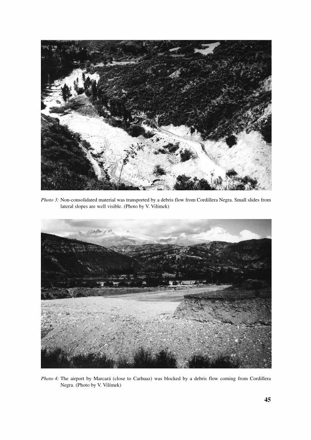
Photo 3: Non-consolidated material was transported by a debris flow from Cordillera Negra. Small slides fromlateral slopes are well visible. (Photo by V. Vilímek)
Photo 4: The airport by Marcará (close to Carhuaz) was blocked by a debris flow coming from CordilleraNegra. (Photo by V. Vilímek)

46
Photo 6: The upper part of the rockslide (Photo 5) is heavily disturbed with large open trenches betweenseparate blocks. (Photo by V. Vilímek)
Photo 5: Cañón del Pato could be blocked by a rock slide especially during an earthquake. Detached slabs arecreeping under gravity. (Photo by V. Vilímek)

47
Photo 7: Large blocks of granodiorites are spread on the SW slope of Huascarán Mt., due to ice- and rockfalls.(Photo by V. Vilímek)
Photo 8: Some blocks of granodiorites reached the lower part of the Cordillera Negra slope, which consists ofvolcanic material in this area, after the rockslide from Huascarán Mt. It means that these blocks wentacross the Santa River up into the opposite slope of Huascarán. (Photo by V. Vilímek)

48
Fig. 3: Cañón del Pato1. buildings, 2. fluvial deposits, 3. alluvial deposits, 4. rock slides, 5. rock platforms, 6. slip directions, 7. supposed fault, 8. direction of slope movements.

Pato is threatened by general slippage of a zone 900 m long and about 360 m wide froman altitude of about 2,320 m. The volume of potentially unstable huge main blocks isabout 600,000 m3 in area about 315,000 m2. The metamorphic rocks occurred in slabs ofdifferent thickness and other parts are covered by debris. In the case of the slabs, naturalstratification (foliation) prevails. For understanding the intensive fracturing, it isimportant to study the mechanism of batholith intrusion. Due to both the steepness of theslope and the inclination of stratification down the slope, gravitational processes play animportant role in slope movement development.
It is possible to divide the area of sliding into different parts according to the typeand intensity of process (Fig. 3). A rockslide of about 86,000 m2 (Zapata 1987) issituated on the right bank of the Santa River. In the lower part, the slabs are partlysitting in the river bed supporting the upper part of the hanging rocks. The blocks weremoved and they found temporary equilibrium. The general inclination of the masswhich slid is 42°. In addition the rock slide narrowed the river bed and the flowingwater must produce considerable stress on rocks. Visible lateral erosion was not seen.But the locality could be under strong pressure during a high water level, especially atthe time of carrying debris from some local tributary debris flow. The other processwhich could trigger a slide is the seismic shaking. Seismic hazards are rather strong inthis area.
There is a step like crest at the confluence of Rio Cedros (a fault based valley) and RioSanta, which consists again of a triangular block. The influence of crossing faults issupposed. The area is also significant by enormous accumulation of transported materialfrom the tributary (Rio Cedros) which is presented by a dissected fan and moreoverremnants of this material coming from a huge debris flow are hanging up in the oppositewall – the left hand bank of the Santa River valley.
Rock platforms are situated at a level of 1880–1900 m. Some of their blocks have signsof rotation and some are chaotically distributed. They are also source of potential hazard,especially in the case of an earthquake.
The sliding area in general was influenced by contact metamorphism and, moreover, issituated at a fault crossing (the main Cordillera Blanca fault and the perpendicular faultof the Los Cedros valley). The intensity of fracturing could coincide with the intensity offaulting. The weathered material does not contain clay – this is not the reason for sliding.
Apart from the described rocksliding, there are, in the upper zone, open trenches whichcomprise a considerable hazard during an earthquake. Any significant slope movementcould totally block the Santa River and form a lake, which after sudden break wouldproduce a flooding situation. The present equilibrium, determined only from visualobservations, is only a temporary state.
4. Conclusions
There are different types of slope movements in Callejón de Huaylas according tovariability of geological and tectonical setting. Most of them were triggered by intensiverains or earthquakes. The anthropological factor does not belong to the main ones. Apart
49

from local investigations, no inventory of slope movements exists. The youngest faultzone is also accompanied by small landslides.
Using a combination of geological, geomorphological and recent geodynamicalinvestigations we are able to distinguish 3 basic engineering geological zones withdifferent conditions and types of slope deformation. The first one is the mountain rangeof the Cordillera Blanca, formed predominantly by Miocene granitic rocks disrupted bytectonic ruptures and affected by recent exogenous geodynamic processes like glaciers.The geological setting is appropriate for huge rockfalls.
The second one is the mountain range of the Cordillera Negra formed previously byCretaceous formation with volcanic rocks and sediments. Volcanic rocks weatherrelatively quickly and produce material for debris flows of different volume.
The third one is a zone of Tertiary-Quaternary filling sediments of the Santa Rivervalley, formed by slightly or not cemented fluvio-glacial sediments. There, it is possibleto observe different types of slope deformations from rotational slides, block slopedeformations or debris flows.
About 93 slope movements with propriety damage or lives lost were observed duringthe first half of 1998 due to the El Niño effect. Some other slope movements did not causeany damage and therefore were not registered by regional offices. In the Santa Rivervalley (between Huaraz and Yungay towns) we observed some tens of such landslides.The main road along the Santa River was constructed previously in the fluvial and glacio-fluvial sediments. During February 1998 the road was damaged in 4 places betweenHuaraz and Yungay by debris flows from the west side, from the Cordillera Negramountain range.
In these registered landslides 25 people died, 856 houses were destroyed and 2,917damaged. Some 62 bridges were destroyed, 56 of them damaged and 4.8 km of roadswere totally destroyed (83.7 km were damaged) by flood and slope movements
Using a detailed field investigation, the reach of pre-Columbian rockfall has beenidentified at a level of 2,540 m a.s.l. It means 150 m above the water level of Santa Rivernear Matacoto village, higher than has been mentioned in previous works. On the otherhand, it is not possible to distinguish so precisely the description of the remnants of pre-Columbian rockfall on the slopes of the Huascarán Mt.
The area of considerable slope movements on the right bank of Santa River in Cañóndel Pato consists of different parts (Fig. 3). A rockslide of about 86,000 m2 moved downto the river bed, but a lot of slabs are still hanging higher in the slope under temporaryequilibrium which could be disrupted by any stronger earthquake. Another potentialhazard results from rock platforms situated at a level of 1,880–1,900 m a. s. l. They arechaotically distributed and some of them bear signs of rotation.
Acknowledgements
The research was supported by the Research Plan No. MSM 1131 00007 and by theGrant Agency of Charles University No. 224/2001/B-GEO/PrF which is fullyappreciated.
50

References
AMES A. M. (1987): Informe de la inspeccion del alud del Nevado Huascaran producido el 16 de Diciembrede 1987. Report Hidrandia s.a., Glaciologia e Hidrologia, 4 p., Huaraz, Peru.
CLUFF L. S. (1971): Peru earthquake of May 31, 1970; Engineering geology observations. Bulletin of theSeismological Society of America, 61 (3), June, 511–533.
DALMAYRAC B. (1974): Un exemple de tectonique vivante: les failles subactuelles du pied de la CordilléreBlanche (Pérou). Cahier ORSTOM, sér. Géologique, 7 (1), 19–27.
LOMNITZ C. (1971): The Peru earthquake of May 31, 1970: Some preliminary seismological results. Bulletinof the Seismological Society of America, 61 ( 3), June, 535–542.
PLAFKER G., ERICKSEN G. E., CONCHA J. F. (1971): Geological aspects of the May 31, 1970, Perúearthquake. Bulletin of the Seismological Society of America, 61 ( 3), June, 543–578.
PLAFKER G., ERICKSEN G. E. (1978): Nevados Huascarán avalanches, Peru. In Rockslides and avalanches,Natural Phenomena, 277–314, Voight B. ed., Elsevier. Amsterdam – Oxford – New York.
REYNOLDS J. M. (1989): Hazards assessment in the Callejón de Huaylas, Cordillera Blanca, Peru. Report forHidrandia S. A., Glaciología e Hidrología, No. 857, 71 p., Huaraz, Peru.
VILÍMEK V., ZAPATA M. L. (1998): Geomorphological response of neotectonic activity along the CordilleraBlanca fault zone, Peru. In: J. Kalvoda, Ch. Rosenfeld eds., Geomorphological Hazards in High MountainsAreas, 1998, 245–262, Kluwer Academic Publishers, 314 p., London.
WELLS L. E. (1987): An alluvial record of El Niño events from northern coastal Peru. Journal of GeophysicalResearch, 92, C13, 14 643–14 470.
ZAPATA M. L. (1987): Estudio geologico definitivo sobre deslizamientos y derrumbes de roca en la zona deBocatoma de la central hidroelectrica Canon del Pato. Report for Hidrandia s.a., Glaciologia e Hidrologia,Huaraz, 31 p., Peru.
SVAHOVÉ POHYBY V CALLEJÓN DE HUAYLAS V PERU
R é s u m é
Cordillera Blanca je budována především z granitických hornin, byla porušena tektonickými pohyby a údolíjsou přehloubena ledovci. Strmé skalní stěny porušené exfoliací podléhají skalním řícením. Některá skalní čiledová řícení jsou podmíněna výskytem zemětřesení. Cordillera Negra je tvořena především z vulkanickýcha sedimentárních hornin. V důsledku intenzivního zvětrávání je na svazích velké množství nesoudržnéhomateriálu pro různé typy svahových pohybů (např. bahnotoky, přívalové proudy). Sedimenty v údolí řeky Santymají charakter fluvio-glaciální, místy s vulkanickými sedimenty. Většinou se jedná o nezpevněné materiály, vekterých vznikají rotační sesuvy, svahové pohyby blokového typu či kamenné proudy.
Terénní výzkum a studium leteckých snímků z oblasti Huascaránu byly zaměřeny na upřesnění rozsahustarého skalního řícení, ke kterému došlo v prehistorickém období. Na jeho existenci upozornili již Plafker,Ericksen (1978). Při našem detailním terénním průzkumu protilehlého svahu Huascaránu byly identifikoványzřícené hmoty v nadmořské výšce až 2540 m n.m., a to 150 m nad úrovní řeky u obce Matacoto. Relativně-souvislejší výskyt těchto zřícených hmot, který je odkryt říční erozí, leží v nadmořské výšce 2525 m n. m., tedy135 m nad hladinou řeky. Mohutné balvany, kterými zmínění autoři dokládají rozsah prehistorického řícení nasvazích Huascaránu, mohly být přemístěny ledovcem a nelze je tedy jednoznačně považovat za důkaz. Obdobnébloky se vyskytují také v boční moréně na pravém břehu řeky Shacsha (vytéká z jezer Llanganuco); tedy zdejiž prokazatelně mimo akumulační oblast dávného skalního řícení ze severního vrcholu Huascaránu.
Svahové pohyby v kaňonu del Pato jsou převážně blokové skalní sesuvy, které ohrožují ústí vodníhopřivaděče podzemní hydroelektrárny, včetně doprovodných staveb. Spodní část porušené zóny dosahuje okrajeřečiště a při zemětřesení či větší povodni hrozí další aktivace svahového pohybu. Vzhledem k úzkému korytuřeky Santy může při rozsáhlejším svahovém pohybu dojít k úplnému přehrazení toku akumulační haldousesuvu, jejíž protržení by mělo katastrofické následky.
51