slide: 1 oceanobs 2009, 24 september 2009 session 4b satellite operational satellite missions...
TRANSCRIPT
Slide: 1OceanObs 2009, 24 September 2009Session 4b Satellite
Operational Satellite Missions
Francois Parisot (EUMETSAT)
with contributions from the plenary paper co-authors
Slide: 2OceanObs 2009, 24 September 2009Session 4b Satellite
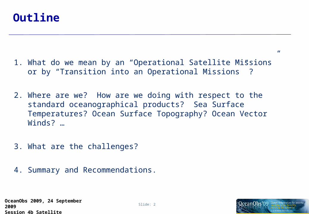
Outline
1. What do we mean by an “Operational Satellite Missions” or by “Transition into an Operational Missions” ?
2. Where are we? How are we doing with respect to the standard oceanographical products? Sea Surface Temperatures? Ocean Surface Topography? Ocean Vector Winds? …
3. What are the challenges?
4. Summary and Recommendations.

Slide: 3OceanObs 2009, 24 September 2009Session 4b Satellite
Differences Operational versus Research Mission
Operational Mission Research MissionKey Driver User/Service Requirements Technological/Scientific challenge
Budget Operational Agencies(NOAA, EUMETSAT,…)
R & D agencies (NASA, ESA,CNES,…)
Users Operational forecaster Scientists
Availability Guaranteed, Monitored Best Effort
Dissemination Operational Networks FTP, by and to science consortia
Support Pro-active 24/7 Ad Hoc
Sustainment Continuous Incremental
We know, there is not always a so strong distinction, but rather a mixing from both categories.

Slide: 4OceanObs 2009, 24 September 2009Session 4b Satellite
Example
Is altimetry now operational ?
YES if we consider the routine availability of timely, accurate, and validated individual and multi-mission products from the current flying missions.
NO if we look at “fragility” of the system and the time it takes to decide any new mission, or the lack of use and maybe even lack of awareness of the key products in substantial number of countries.

Slide: 5OceanObs 2009, 24 September 2009Session 4b Satellite
Operational Transition
• When research missions have clearly demonstrated operational usefulness, this usefulness must become the strongest driver behind follow-on missions.
• Programmatically this follow-on mission or rather a sequence of missions have to make a transition to become a component in a wider operational structure and planning.
This represents new challenges and constraints on the mission itself, the programmatic procurements and the mission operations.

Slide: 6OceanObs 2009, 24 September 2009Session 4b Satellite
Transition: From the R&D phase to operations
1. Transition Scenario’sOceanObs 1999 St. Raphael France:
[Ratier,1999]
“… Missions may well fall between two stools, if development and
operational agencies do not balance their respective investments, or if
they compete for the same resources or fail to agree on
appropriate transition scenarios.”
Slide: 7OceanObs 2009, 24 September 2009Session 4b Satellite
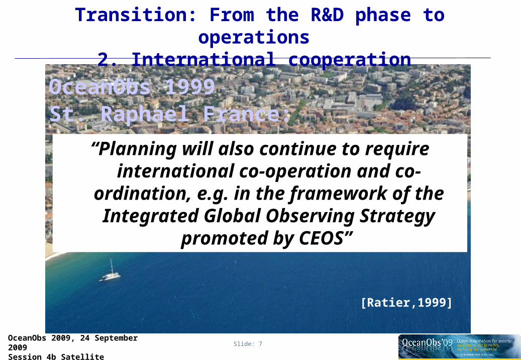
Transition: From the R&D phase to operations
2. International cooperation
OceanObs 1999 St. Raphael France:
[Ratier,1999]
“Planning will also continue to require international co-operation and co-
ordination, e.g. in the framework of the Integrated Global Observing
Strategy promoted by CEOS”

Slide: 8OceanObs 2009, 24 September 2009Session 4b Satellite
Transition: From the R&D phase to operations3. User pull
We need Timely Data Access!
GODAE Final Symposium 2008 Nice France:
[Wilson et al, 2008]

Slide: 9OceanObs 2009, 24 September 2009Session 4b Satellite
OCEAN OBS 2009
Deamons
OceanObs 2009: How far are we to transition into operational satellite oceanography?
OceanObs 1999:Development and Demonstration
Slide: 10OceanObs 2009, 24 September 2009Session 4b Satellite
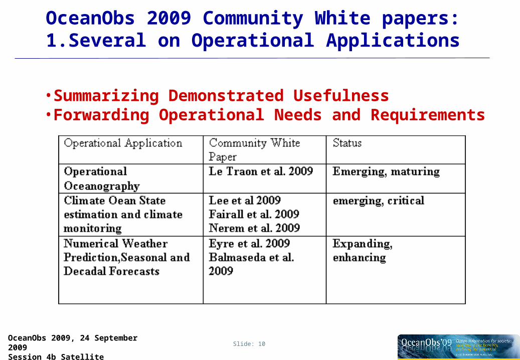
OceanObs 2009 Community White papers:1.Several on Operational Applications
•Summarizing Demonstrated Usefulness •Forwarding Operational Needs and Requirements

Slide: 11OceanObs 2009, 24 September 2009Session 4b Satellite
OceanbObs 2009 Community White Papers:2.Several on the standard products
•Summarizing Demonstrated Usefulness •Forwarding Operational Needs and Requirements

Slide: 12OceanObs 2009, 24 September 2009Session 4b Satellite
No time to discuss the mission schedules in detail !
Slide: 13OceanObs 2009, 24 September 2009Session 4b Satellite
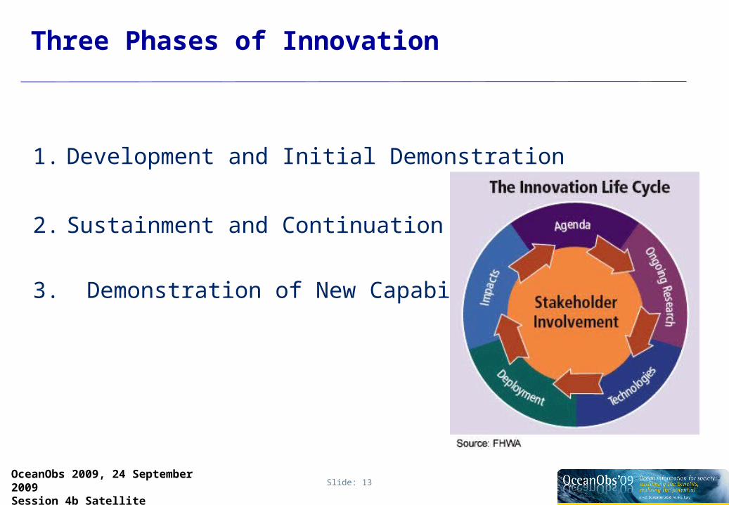
Three Phases of Innovation
1. Development and Initial Demonstration
2. Sustainment and Continuation
3. Demonstration of New Capabilities

Slide: 14OceanObs 2009, 24 September 2009Session 4b Satellite
Ocean Missions: Sea Surface Temperature
Development and Demonstration
Sustainment and Continuation New capabilities
SLTSR (Sentinel 3A, 3B, 3C, 3D ..)
AVHRR/3 on METOP and NOAA series (IJPS)
and follow-on’s as part of JPS
AVHRR onTIROS-N, AHRR/2 on NOAA-7
MicroWat concept
ATSR (ERS), AATSR (ENVISAT)
AMSR-E on Aqua
We don’t cover the geostationary missions in this overviewAMSR-2 on GCOM-W 1, 2 and 3.

Slide: 15OceanObs 2009, 24 September 2009Session 4b Satellite
Ocean Missions: Ocean Surface Topography
Development and Demonstration
Sustainment and Continuation New Capabilities
HY-2B, HY-2C, HY-2D
GFO, GFO2GEOSAT
SWOTTopex/Poseidon, Jason1 Jason2, Jason3, Jason-CS
RA (ERS), RA2 (Envisat)SARAL
SRAL (Sentinel 3A, 3B, 3C, 3D .. )
IRAC
CFOSAT
HY-2A

Slide: 16OceanObs 2009, 24 September 2009Session 4b Satellite
Ocean Missions: Ocean Surface Vector Winds
Development and Demonstration
Sustainment and Continuation New Capabilities
SCAT on HY-2B, HY-2C, HY-2D
ASCAT (METOP,1,2,3), SCA on Post EPS
QuikSCAT, ADEOS I,II XOVWM
AMI (ERS1, ERS2)
DFS on GCOM W1,W2
SCAT on OceanSat 2
CFOSAT
SCAT on HY-2A
SCAT on OceanSat 3
We don’t cover Sea State Applications of SARMissions in this overview

Slide: 17OceanObs 2009, 24 September 2009Session 4b Satellite
Ocean Missions: Ocean Colour
Development and Demonstration
Sustainment and Continuation New Capabilities
SeaWifs, MODIS,VIIRS on NPP
OLCI (Sentinel 3A, 3B, … )
MERIS (envisat)
VIIRS on NPOESS-C1
GOCI (geostationary!)
OCM on OceanSat 2,3OCM on IRS-P4
Geo-cape, Geo-Oculus
Slide: 18OceanObs 2009, 24 September 2009Session 4b Satellite
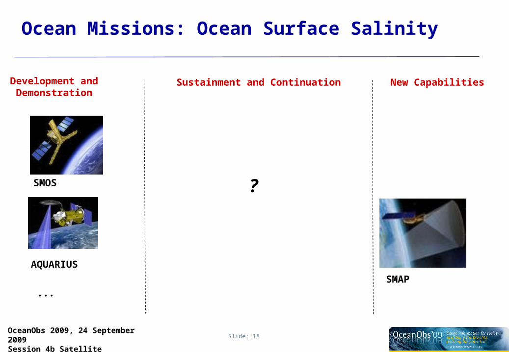
Ocean Missions: Ocean Surface Salinity
Development and Demonstration
Sustainment and Continuation New Capabilities
SMOS
AQUARIUS
?
SMAP
...

Slide: 19OceanObs 2009, 24 September 2009Session 4b Satellite
International Coordination and Cooperation
Slide: 20OceanObs 2009, 24 September 2009Session 4b Satellite
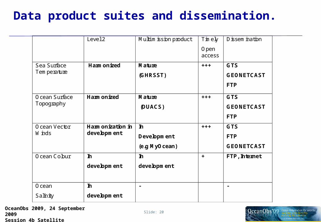
Data product suites and dissemination.
Level 2 Multi mission product Timely
Open access
Dissemination
Sea Surface Temperature
Harmonized Mature
(GHRSST)
+++ GTS
GEONETCAST
FTP
Ocean Surface Topography
Harmonized Mature
(DUACS)
+++ GTS
GEONETCAST
FTP
Ocean Vector Winds
Harmonization in development
In
Development
(e.g MyOcean)
+++ GTS
FTP
GEONETCAST
Ocean Colour In
development
In
development
+ FTP, Internet
Ocean
Salinity
In
development
- -

Slide: 21OceanObs 2009, 24 September 2009Session 4b Satellite
Summary
We can restate the GODAE final symposium conclusion of Wilson et al [2008] that
Impressive progress made over the last decade!
Sea Surface Temperature FineOcean Surface Topography FineOcean Vector Winds Fine enhancing international scientific
cooperation and coordinationOcean Colour On the right trackOcean Salinity Emerging…
•Based on a qualitative assessment of e.g. the OceanObs2009 Community White Paper’s one could argue that indeed operational maturity is most advanced in those chains where the international cooperation and coordination is the most intense.

Slide: 22OceanObs 2009, 24 September 2009Session 4b Satellite
Recommendations for the Future
• Keep on making work of timely data access to really establish the user pull. Develop integrated, easy-to-use products, each available from a single point of access in a common format and in a timely manner
• Keep up and enhance international cooperation to ensure that all data are freely available to all in a timely manner; to share experience in how to calibrate the sensors, use the data, harmonize orbits for optimal coverage
• Foster the interplay between science teams and operational teams and program officers. Initiate/strengthen/maintain partnerships between research and operational users
• Ensure an adequate programmatic answer to the observations sustainment challenge widely expressed here
Slide: 23OceanObs 2009, 24 September 2009Session 4b Satellite
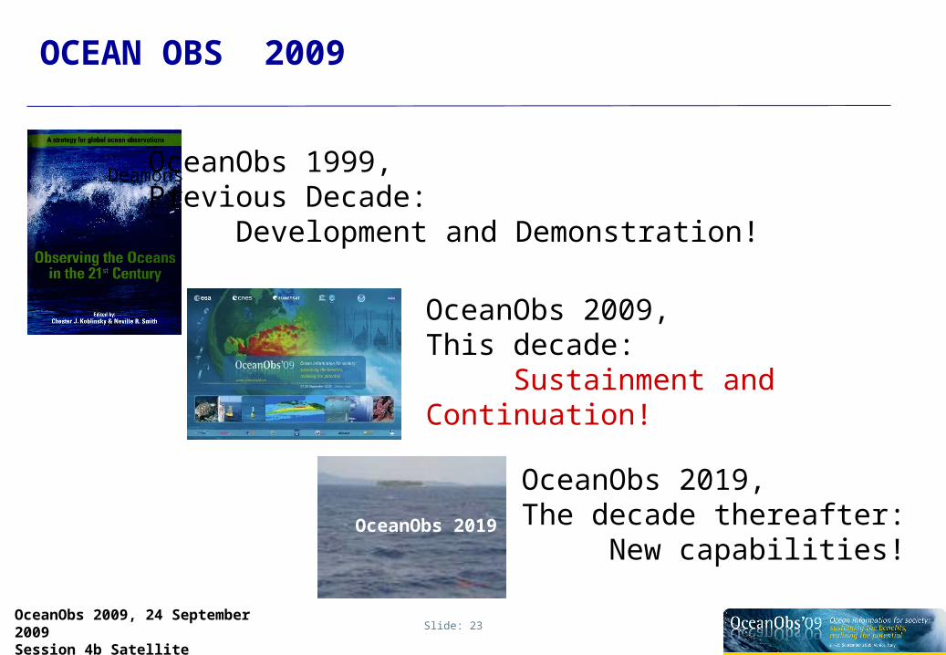
OCEAN OBS 2009
Deamons
OceanObs 2009, This decade:
Sustainment and Continuation!
OceanObs 1999,Previous Decade:
Development and Demonstration!
OceanObs 2019
OceanObs 2019, The decade thereafter:
New capabilities!

Slide: 24OceanObs 2009, 24 September 2009Session 4b Satellite
END