“sitting on the dock of the bay” 100 years of photographs ... · “sitting on the dock of the...
TRANSCRIPT

“Sitting on the Dock of the Bay” 100 years of Photographs from the
San Diego Historical SocietyLinda A. Canada
San Diego Bay is one of the region’s greatest natural resources. For the earliest inhibitants, it was a place of beauty, a source of food and refuge, a transportation corridor, and a meeting place. Photographs from the San Diego Historical Society’s collection, spanning more than one hundred years, illustrate the many changes the bay has undergone.1
Physical forces have transformed the bay. Although it is still approximately fourteen miles long from the entry off Point Loma to the salt pans at its southern end, the depth and contours of the bottom of the bay have changed as military and commercial uses required removal of sand bars and deepening of the main channel. As early as 1850, city leaders realized the importance of improving the harbor for commerce. However, significant amounts of dredging were required to build and maintain an adequate shipping channel. This expensive work was not within the budget of the City of San Diego. Members of the Chamber of Commerce and local businessmen strongly encouraged the Navy to add new facilities around San Diego Bay. In fact, the greater part of bay improvements were eventually funded by the United States government.2
Other physical changes involved redirecting the San Diego River into Mission Bay, using dredge spoils to create Harbor and Shelter Islands and much of the land beneath the airport, and reshaping the shores of Coronado for military needs. These changes included filling in Spanish Bight and Whaler’s Bight, both on Coronado’s North Island, and broadening that area by placing dredge spoils along its north shore. They allowed for construction of more runways and additional military housing, and training facilities during World War II. Just south of Glorietta Bay in Coronado, a new peninsula was built as a training base for the Navy’s underwater demolition teams, later known as SEALs.3
Transportation and commerce have always been complementary uses of San Diego Bay. Goods and people arrived in San Diego by ship during the nineteenth and early twentieth centuries. As early as 1850, William Heath Davis built a wharf to accommodate ships and to draw people to his “New San Diego” settlement— 160 acres of land located approximately three miles south of Old Town.4 By 1887, wharves and the small businesses and residences that supplied their needs were common sights along the bay. As time passed, the nature of these businesses changed, ranging from shipyards and chandlers, to lumberyards and canneries. Fishing boats unloaded their catch along the Embarcadero.
Today, land along the bay supports both recreational and military uses. The
�
Linda A. Canada is a local historian who returned to the field of history following a twenty–year career as a lawyer. She was curator of the Museum of San Diego History’s exhibition for children, Romp!, and has curated public exhibitions for local historical societies.

Major physical changes to the bay are apparent when comparing this map to the 1983 map, opposite. The 1873 Hensley map shows the San Diego River flowing into the bay between Roseville and Old Town. Coronado’s Spanish Bight dividing the island is readily apparent, as is the much smaller Whaler’s Bight at its northwestern edge. The narrow opening of the bay near the tip of Point Loma is also clearly visible. ©SDHS #88:16984.
The Journal of san Diego History
�
marketing website for the San Diego Unified Port District lists ten miles of jogging trails, sixteen public parks, sixteen marinas and three museums. Because military facilities along the bay are not within the jurisdiction of the Port District, the Port’s comprehensive summary of land uses for its 2,500 acres of land and 2,660 acres of water includes in its Master Plan only one small 26 acre parcel leased to the Navy for its Fleet School.5
The following photographs all come from the Research Library and Photographic Collections of the San Diego Historical Society. They depict the bay as it has evolved over ten decades, from the late 1880s to the early 1980s.

This 1983 aerial photograph shows the area between Roseville and Old Town filled in for use as San Diego International Airport, also known as Lindbergh Field. Coronado’s appearance is very different, with its size swelled by the addition of dredge spoils to create an expanded northwestern shore. A new peninsula below the curve of the San Diego-Coronado Bay Bridge is a Navy installation. Notice the wide shipping channel to support commerce and the Navy. ©SDHS, Map Collection.
�
“Sitting on the Dock of the Bay”
This etching, ca. 1890, shows ships carrying passengers and goods heading toward wharves to discharge their cargoes. ©SDHS #80:3988.

The Journal of san Diego History
�
An early military use of the bay front is recorded in this photograph of two cannons on Market Street at the foot of Kettner Boulevard. The first military barracks were built on land donated by William Heath Davis, founder of New Town, in 1850. ©SDHS #1026.
In 1887, mudflats along the water’s edge were home to people working on the wharves or in small businesses supporting the shipping trade. Tracks laid along the bay linked San Diego by train to markets and potential immigrants on the East Coast. ©SDHS #3082.

�
“Sitting on the Dock of the Bay”
By 1905, lumberyards were a common sight along the bay as the demand for building materials increased for new housing. Beyond Western Lumber Company, seen here, the open land was a tidal flat where boats settled on their keels, awaiting the incoming tide. ©SDHS #484.
Lumberyards around San Diego Bay included Russ, Benson, Frost and Western Lumber Company. In this 1910 image, Western Lumber Company had increased its storage capacity by building out over the bay. In the distance, the long wharf is where the Pacific Coast Steam Ship Company brought passengers to San Diego beginning in the 1850s. ©SDHS #12578.

The Journal of san Diego History
�
The dredging of San Diego harbor in order to create Harbor Drive is shown in this photo, ca. December 1913 ©SDHS UT #5149, Union–Tribune Collection.
New Navy technology came to San Diego with the first aircraft carrier, the USS Langley, in 1924. This 1927 photograph, taken when she was moored at North Island Naval Station (lower left), shows her awkward appearance due to the wooden deck added to the top of a former coal carrying ship.6 ©SDHS #80:7714.

�
“Sitting on the Dock of the Bay”
Sailors engaged in a race against four other “pulling” boats duringWorld War I, ca. 1918. Large ships often had competitive rowing teams as part of their athletic program. The sailors’ neckerchiefs indicate that they are wearing dress whites so this event may have taken place on a Sunday. ©SDHS 4382-7.
Transportation across the bay to Coronado and Point Loma was solved by a system of ferries. Here, in 1910, a small ferry has left the West Santa Fe Wharf at the foot of Market Street. Also visible at the left are the coal bunkers of the Spreckels Company. ©SDHS #81:9628.

The Journal of san Diego History
�
View of the piers and wharves of the San Diego waterfront, looking northwest towards Point Loma. ©SDHS #90:17839.
Ferry transportation became more important by 1925 and evolved from passenger-only service to a series of car ferries. After the East Santa Fe Wharf was removed in the mid-1920s, a new ferry dock was built. Car parks for the ferry were adjacent to the ferry terminal.7 ©SDHS #90:18138-544.

�
“Sitting on the Dock of the Bay”
Members of the ZLAC rowing club standing on a pier, ca. 1929. The club, founded in 1892 by Zulette Lamb and three sisters, Lena, Agnes, and Caroline Polhamus, remains vital in 2006. ©SDHS UT #8284-106, Union–Tribune Collection.
Coal bunkers operated by the Spreckels Company were a landmark on the bay from the time of their construction in 1888 until the late 1920s when they were torn down. Seen at top center of this 1911 image, the S–shaped wooden wharf with its tall black bunkers held 15,000 tons of coal.8 ©SDHS #82:13208.

The Journal of san Diego History
�0
People in bathing suits on a swimming platform in San Diego Bay, 1922. ©SDHS #94:19136-179.
Japanese sailors load coal into the coal bunkers of a cruiser, ca. 1908. ©SDHS #7348.

��
“Sitting on the Dock of the Bay”
Several freighters tied to two piers in San Diego harbor, ca. 1935. San Diego Water Taxi is between the rows of ships. The ship Oakland is on the right. ©SDHS Sensor #24-48, Sensor Collection.
A 1936 dredging operation created the site for a new police station that would be constructed on Harbor Drive. In the 1980s, the remaining land became Seaport Village. In this 1936 photograph, lumber company wharves are almost gone. Fish brokers and markets occupy a small pier to the left of the ferry terminal. ©SDHS #79:741-145.

The Journal of san Diego History
��
San Diego’s rich supply of fish created an industry in which immigrants from many countries worked as laborers on the boats and in the canneries. In 1936, boats unloaded at the Van Camp Seafood dock. Perched over the mudflat to the right is the pier known as “fish camp,” basic housing that Van Camp provided to Japanese fishing families. ©SDHS Sensor #5-22, Sensor Collection.
The police station had been completed in this 1940 view looking north. The declining number of piers and docks suggests that the commercial center of San Diego, by this time, had moved north, toward the foot of Broadway. Much of the Embarcadero had been completed, but fishing boats were still moored north of the City-County Administration Building. ©SDHS #79:741-573.

��
“Sitting on the Dock of the Bay”
Boatbuilding, both wooden and steel, was another important industry along the bay. Not to be forgotten was San Diego’s venture into building reinforced concrete-hulled ships in the 1920s. After World War II ended, requests for newer and bigger fishing boats replaced military orders. In this 1947 photograph, the Mary Barbara is launched at National Iron Works.9 ©SDHS #1998/032-10.
The entire San Diego Bay is shown in this 1936 photograph taken over Otay Mesa. The curve of the Strand portion of the Coronado peninsula on the left ends at the large flat area of North Island Naval Air Station. White areas are sand and rock that have been dredged from the bay to enlarge the base. Dark areas that appear to be fenced in the bottom part of this image are evaporation ponds for producing salt from sea water. ©SDHS OP #16315-10.
The Journal of san Diego History
��
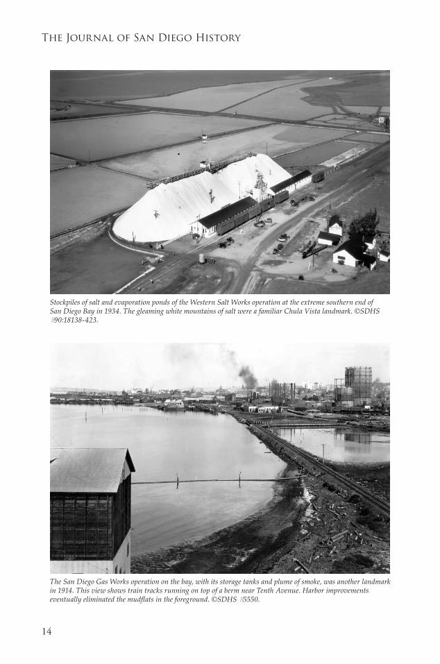
The San Diego Gas Works operation on the bay, with its storage tanks and plume of smoke, was another landmark in 1914. This view shows train tracks running on top of a berm near Tenth Avenue. Harbor improvements eventually eliminated the mudflats in the foreground. ©SDHS #5550.
Stockpiles of salt and evaporation ponds of the Western Salt Works operation at the extreme southern end of San Diego Bay in 1934. The gleaming white mountains of salt were a familiar Chula Vista landmark. ©SDHS #90:18138-423.

��
“Sitting on the Dock of the Bay”
In June 1941, the Star of India, an iron-hulled sailing ship built in 1863, was a derelict moored near the site of today’s Marriott Hotel. The ship had been brought to San Diego by the Zoological Society of San Diego as a possible site for a floating aquarium in 1927 but not refurbished until years later. In 1976, she was put to sea for the first time in fifty years to honor the U. S. Bicentennial.10 ©SDHS #P-1261.
Even before World War II, a shortage of dock space in San Diego Bay caused vessels to be moored in the main channel. In the foreground, automobile parking also appears to be a problem in 1936 as evidenced by cars parked around Lane Field where a baseball game is underway. Bill Lane brought his Pacific Coast League Padres to San Diego in 1936, and they played at this field with its wooden bleachers adjacent to the Bay until 1958 when the team moved to the newly built Westgate Park in Mission Valley.11 ©SDHS, UT 8285, Union-Tribune Collection.

The Journal of san Diego History
��
This 1985 view of the downtown area of San Diego completes this one-hundred-year photographic survey of changes around San Diego Bay. In this single image, many of the present land uses around the Bay are represented: (from left) Navy Region Southwest buildings; fishing boats moored at the docks; Seaport Village representing tourism and retail uses; and Embarcadero Park and a pleasure boat marina for recreation. For all its changes, San Diego Bay remains the premier natural resource of our region. ©SDHS #1998/042-01408.
This 1943 high aerial view is rare. Wartime photography restrictions permitted few such photographs to be taken. It shows the new runways built at North Island and the new site for the SEAL base to the right of Coronado. Dredging to fill in the Spanish Bight at Coronado had begun. ©SDHS #15098.

��
“Sitting on the Dock of the Bay”
NOTESFor more information, see a special issue of Mains’l Haul, published by the Maritime Museum of
San Diego, with articles by Ray Ashley, Bruce Linder, John Fry, August Felando, James Mills, Karen Scanlon, Robert Wright and Abraham Shragge: “Developing San Diego Bay in the 20th Century,” Mains’l Haul: A Journal of Pacific Maritime History 38, no. 4, 39, no. 1 (2002-03).
Abraham J. Shragge, “Boosters and Bluejackets: the Civic Culture of Militarism in San Diego, California, 1900-1945,” PhD diss., University of California, San Diego 1998, 63-64.
Bruce Linder, San Diego’s Navy (Annapolis, Maryland: Naval Institute Press, 2001), 134.
See William E. Smythe, History of San Diego 1542-1908 (San Diego: The History Company, 1908).
San Diego Bay: The Big Bay Fast Facts http://www.thebigbay.com/mediacenter/fastfacts.asp (accessed July 8, 2006); Port Master Plan, August 2004, Table Four: Land and Water Use Allocation Summary. This plan was provided to the author by Tim Deuel, archivist for San Diego Unified Port District, on July 12, 2006. It is also available on the Unified Port of San Diego’s website, http://www.portofsandiego.org/ (accessed July 14, 2006).
The USS Langley was eventually joined by the Lexington and the Saratoga as part of the Pacific Fleet. In 1931, when Saratoga entered the freshly dredged harbor, she was the largest vessel ever to enter San Diego Bay. Linder, 81-89.
Jerry MacMullen, who chronicled much of San Diego’s maritime history, devoted an entire chapter to the discussion of the various ferries that crossed San Diego Bay until completion of the San Diego-Coronado Bay Bridge in 1969 rendered them obsolete. Jerry MacMullen, They Came By Sea (San Diego: Ward Ritchie Press, 1969).
MacMullen, 23.
Robert Eberhardt, “Concrete Shipbuilding in San Diego 1918-1920,” The Journal of San Diego History (JSDH) 41, no. 2 (1995): 110-135.
Trudie Casper, ed., “Jerry MacMullen, an Uncommon Man Part II,” JSDH 28, no. 1 (1982): 11-34. See also the special issue, “New Tales of Euterpe: Star of India as a British Emigrant Ship,” Mains’l Haul 39, nos. 3 & 4 (2003).
William G. Swank and James D. Smith III, “This was Paradise: Voices of the Pacific Coast League Padres 1936-1958,” JSDH 41, no. 1 (1995): 3-37.
1.
2.
3.
4.
5.
6.
7.
8.
9.
10.
11.