sitka ranger district preliminary photo trip report...
TRANSCRIPT

Sitka Ranger District
Preliminary Photo Trip Report: Starrigavan Landslide – September 18/19, 2014
Martin Becker – Watershed Program Coordinator
Last week, either late Thursday night (9/18) or early Friday morning (9/19), a significant
landslide occurred on the North Fork of Starrigavan Creek. Two smaller slides also occurred in
the valley, one at the very head of the NF and one on the side slopes of the South Fork. The SF
slide has crossed and blocked the “C Loop” of the OHV trail. The Starrigavan Creek watershed is
located on the north end of the Sitka Road system. The first report of the slide came from Phil
Mooney (ADF&G) early Friday morning as he was trying to download a few of his deer cameras
that were located in the upper valley. I was out of town on a riparian thinning trip at False
Island and was not able to investigate till this Monday morning (9/22), when I, Mike Mullin
(SRD-Rec), Jacquie Foss (SO-Soils) and KK Prussian (SO-Hydro) made a site visit. Below are some
pictures of the slide and its impacts with descriptions. The slide and its run out zone
encompass approximately 75-100 acres, with an unknown number of additional acres also
affected. The slide also directly impacted approximately 850m of Class I fish habitat along the
mainstem North Fork Starrigavan Creek along with unknown lengths along several Class I
tributaries. Other known damage at this time includes: 3 Coho rearing bonds obliterated with 1
more severely impaired, 2 fish pipes blown out, 1 log stringer bridge destroyed, 2 trail sections
blocked and approximately 300m of OHV trail/ road eroded or buried. A more detailed report
will follow in the coming months after more in-depth site investigations can be made once the
slide areas have fully stabilized and are safe to traverse.

PHOTO 1. Initiation point of main slide on North slope of Starrigavan Valley. Photo curtesy of Harris Air.

PHOTO 2. Base of main slide entering North Fork Starrigavan. Photo curtesy of Harris Air.
PHOTO 3. Base of main slide and run out along North Fork. Photo curtesy of Harris Air.

PHOTO 4. Starrigavan OHV Trail/Road (TROAD). The entire NF has been diverted to the north side of the valley through the woods and enters onto the TROAD below the Pond Spur road. Approximately 175m of TROAD have been impacted at this site. Three quarters of the flow leaves the road surface at the blown fish pipe (new 2013) seen in the middle of this photo. The remaining flow continues down the road and exits at next blown fish pipe (also new 2013) approximately 50m further down the road.

PHOTO 5. Terminus of main debris field. Jacquie (green hardhat) is standing at the junction of the Pond Spur road (left) and the upper Log Stringer Bridge (right).

PHOTO 6. Nice Catch! Upper log Stringer Bridge and now dry mainstem NF Starrigavan
Creek. The bridge has been knocked off its footers and has shifted downstream
approximately 8-10 feet.

PHOTO 7. Looking upstream on the NF from on top of the bridge. This debris jam extends approximately 150m upstream.

PHOTO 8. Looking downstream from upper end of lower debris jam. KK (yellow hardhat) is standing approximately mid jam, with bridge located just beyond the right leaning Red Alders in center of photo.

PHOTO 9. Upper Coho rearing pond obliterated by slide. The two other ponds were to the left of this photo and are covered by the debris jam. The location of this photo is approximately 20m to the right (as looking) from PHOTO 8.

PHOTO 10. Looking upstream alsonfrom PHOTO 8. A second smaller slide can be seen on the forested slope at the head of the valley in the middle of the photo.

PHOTO 11. Looking downstream along slide runout from upper end seen in PHOTO 10.

PHOTO 12. Looking downstream approximately 75m upstream from PHOTO 11.
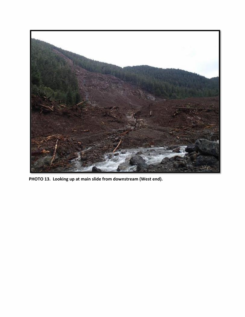
PHOTO 13. Looking up at main slide from downstream (West end).

PHOTO 14. Looking downstream from West end of main slide.

PHOTO 15. Looking up at main slide from center of slide zone.

PHOTO 16. Looking up at East end of main slide.

PHOTO 17. Looking downstream from East end of main slide. Third landslide on North facing slide on the South Fork Starrigavan drainage can be seen in distance.

PHOTO 18. Close up of third landslide. This slide currently blocks the ‘C Loop’ of the OHV trail.

PHOTO 19. Looking downstream at the center of the runout zone from a portion of intact road section in the NF drainage.

PHOTO 20. Sedimentation and filling of New Pond #2 (installed 2013). This pond has lost over half its depth, along with damage to inlet and outlet control structures. Notice the ‘bathtub ring’ of debris along the margins of the pond, which indicates water levels were approximately 4-5 feet higher than that seen in this photo.