site selection document - broxtowe borough council electionssite selection document july 2018...
TRANSCRIPT

Site Selection Document Main Report
Site Selection Document July 2018
Contents
INTRODUCTION .............................................................................................................................3
KEY PRINCIPLES FROM THE ACS...............................................................................................3
THE ACUTENESS OF THE NEED..................................................................................................3
TABLE 1 HOUSING REQUIREMENTS...................................................................................................4
CONSTRAINTS ON SUPPLY AND DIFFICULTIES IN ACHIEVING SUSTAINABLE DEVELOPMENT WITHOUT GREEN BELT DEVELOPMENT........................................................5
TABLE 2 - WHOLE PLAN SUPPLY (2011 TO 2028) URBAN SITES ONLY ..................................................7 TABLE 3 - FIVE YEAR SUPPLY (2018 TO 2023)..................................................................................7 TABLE 4 - WHOLE PLAN SUPPLY (2011 TO 2028) INCLUDING GREEN BELT ALLOCATIONS AT THE POINT
OF ADOPTION OF THE LOCAL PLAN....................................................................................................8 TABLE 5 - FIVE YEAR SUPPLY (2018 TO 2023)..................................................................................8
HARM SPECIFIC TO THE GREEN BELT AND THE EXTENT TO WHICH THE HARM CAN BE AMELIORATED...............................................................................................................................9
SUSTAINABILITY APPRAISAL....................................................................................................10
INFRASTRUCTURE DELIVERY PLAN INCLUDING VIABILITY .................................................10
PUBLIC PARTICIPATION.............................................................................................................11
CONCLUSION...............................................................................................................................11
SITE DETAILS...............................................................................................................................11
CHETWYND BARRACKS.............................................................................................................12
TOTON STRATEGIC LOCATION FOR GROWTH .......................................................................15
BRAMCOTE (EAST OF COVENTRY LANE)................................................................................19
STAPLEFORD (WEST OF COVENTRY LANE) ...........................................................................22
LAND NORTH OF NEWTONS LANE AND EAST OF AWSWORTH BYPASS............................24
EAST OF CHURCH LANE, BRINSLEY ........................................................................................26
WALKER STREET, EASTWOOD .................................................................................................28
SOUTH OF KIMBERLEY INCLUDING KIMBERLEY DEPOT ......................................................30
EMPLOYMENT PROVISION.........................................................................................................32
RETAIL PROVISION .....................................................................................................................33
Page 2 of 33
Site Selection Document July 2018
Introduction The Broxtowe Local Plan comprises two parts. Part 1 is the Aligned Core Strategy (ACS) which was prepared in close cooperation with all of our Neighbours across the Greater Nottingham Housing Market Area and the Broxtowe Core Strategy is fully aligned with the Core Strategies of Nottingham and Gedling. The ACS was adopted in 2014 and withstood a legal challenge in April 2015. Part 2 is the Allocations and Development Managements Policies and this Part 2 Local Plan needs to be in general conformity with and deliver the development requirements set out in the ACS. This document focuses primarily on housing provision, but also explains how the approach to retail and employment provision is undertaken in addition to the approach to development at the Toton Strategic Location for growth near the proposed HS2 station.
Key Principles from the ACS The reason for working together to produce the ACS is a shared belief across the HMA that planning for the future of the area will be more consistent, and the administrative areas of the local authorities will not get in the way of good planning and service delivery (ACS paragraph 1.2.1). The fundamental and shared strategy across the HMA is one of urban concentration with regeneration which is considered to be the most appropriate strategy for the area. This is because it makes the most of existing infrastructure, and because of the significant regeneration challenges faced by parts of the plan area, especially in the main built up area of Nottingham itself, where many of the brownfield development opportunities lie (ACS paragraph 3.2.2). In Broxtowe the majority of the housing provision is to be provided within or adjoining the main built up area of Nottingham which amounts to focussing most development in the urban south of Broxtowe. The reasons for this are explained in paragraph 3.2.22 of the ACS below-‘Areas in the Urban south of Broxtowe benefit from being in the strongest housing sub market, having the most comprehensive public transport links particularly to Nottingham and being in the area of greatest affordable housing need. This strategy therefore performs best in terms of deliverability, sustainability, maximising opportunities for economic development, job creation and contributing to local housing needs.’ There is a strong reference to the importance of neighbourhood plans in delivering this growth (ACS paragraph 3.2.25). In successfully resisting the High Court challenge to the plan by Calverton Parish Council Judge Jay set out a process which would be ideal to follow in paragraph 51 of his judgement which is to identify and then grapple with-
• The acuteness of the need (for new homes)
• Constraints on supply
• Difficulties in achieving sustainable development without Green Belt development
• Harm specific to the Green Belt
• The extent to which the harm can be ameliorated This judgement was focussed on the interaction of Policies 2 and 3 of the ACS and the search sequence they required for sites as follows-
• Within the main built up area of Nottingham
• Within key settlements for growth
• On the edge of the main built up area of Nottingham
• On the edge of key settlements for growth It is within this context that the site selection process in undertaken in this Part 2 Local plan
The Acuteness of the Need Nottingham City Council have worked collaboratively with Broxtowe and other Councils in the HMA to consider whether the housing need to be addressed in the ACS remained appropriate. The conclusion in the Comparison Of The Household Projections Underlying The Greater Nottingham Core Strategies and the CLG 2012-Based Household Projections report is that the population and household projections support the housing provision figures set out in the ACS and there is no need to review them at this time.
Page 3 of 33
Site Selection Document July 2018
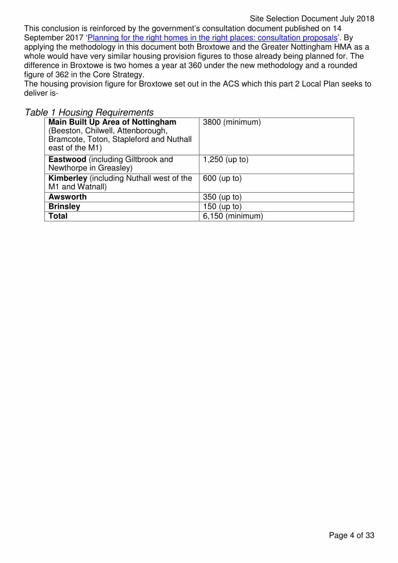
This conclusion is reinforced by the government’s consultation document published on 14 September 2017 ‘Planning for the right homes in the right places: consultation proposals’. By applying the methodology in this document both Broxtowe and the Greater Nottingham HMA as a whole would have very similar housing provision figures to those already being planned for. The difference in Broxtowe is two homes a year at 360 under the new methodology and a rounded figure of 362 in the Core Strategy. The housing provision figure for Broxtowe set out in the ACS which this part 2 Local Plan seeks to deliver is-
Table 1 Housing Requirements Main Built Up Area of Nottingham (Beeston, Chilwell, Attenborough, Bramcote, Toton, Stapleford and Nuthall east of the M1)
3800 (minimum)
Eastwood (including Giltbrook and Newthorpe in Greasley)
1,250 (up to)
Kimberley (including Nuthall west of the M1 and Watnall)
600 (up to)
Awsworth 350 (up to) Brinsley 150 (up to) Total 6,150 (minimum)
Page 4 of 33
Site Selection Document July 2018
Constraints on Supply and difficulties in achieving sustainable development without Green Belt development The Broxtowe SHLAA is a comprehensive document reviewed annually which identifies the urban supply over the whole plan and five year time periods The assessment of a five year supply above follows advice on calculating the supply as set out in the National Planning Practice Guidance (NPPG). This includes the following steps:
1. Applying the need for new homes on the most recently adopted plan taking full account of the objectively assessed need for housing across the whole housing market area. The Core Strategy does this and this is the housing requirement.
2. Applying a buffer of 20% to the requirement where there has been a persistent under-delivery of housing (which in Broxtowe there has been).
3. Applying the shortfall in houses required, compared to those built, in full to the five year requirement (known as the Sedgefield approach).
4. Applying a discount rate based on historical data on lapsed permissions. These are sites with planning permission that are not built.
5. Applying a windfall allowance based on historical data of small sites. These are sites coming forward for development that have not been allocated for housing. Large sites would be allocated in the Part 2 Local Plan.
The justification for following this approach is given below and follows the same numbering.
1. The Core Strategy set the housing provision figure for Broxtowe at a minimum of 6,150 homes of the plan period (2011-28) giving an average of 362 a year albeit with a stepped trajectory with the higher rate of delivery required for the five years between 2018 and 2023. This figure was examined through the Core Strategy process and found to amount to the Broxtowe share of the full and objectively assessed housing need for the housing market area as a whole. As mentioned above the conclusion in the Comparison Of The Household Projections Underlying The Greater Nottingham Core Strategies and the CLG 2012-Based Household Projections report is that the population and household projections support the housing provision figures set out in the ACS and this conclusion is reinforced by the government’s consultation document published on 14 September 2017 ‘Planning for the right homes in the right places: consultation proposals’.
2. Housing completions have risen in Broxtowe for each of the past four years demonstrating an overall upward trend, and for the previous monitoring year the completion figure was 324 homes which is just 36 fewer than the Core Strategy requirement. Nevertheless, it is accepted that the underprovision of new housing in Broxtowe is persistent and that it requires the timely adoption of this Part 2 Local Plan to fully remedy the situation. Consideration has also been given to whether it is appropriate to apply the buffer to both the required housing figure and the shortfall. The buffer has not been applied to the shortfall for a number of reasons. The NPPF at paragraph 47 refers to the buffer to be ‘moved forward from later in the plan period’ to increase the choice of sites. Broxtowe is taking decisive steps to accelerate delivery as explained in more detail below. Also the purpose of applying the buffer is to provide a ‘realistic prospect of achieving the planned supply’. The trajectory on page 79 of the Part 2 Local Plan indicates that anticipated housing completions of over 1000 homes a year for the two monitoring years of 2020/21 and 2021/22 which is more than double the amount BBC has ever achieved. To extend this anticipated delivery rate even further is not realistic. Many of these sites are to be allocated in this Local Plan and are currently in the Green Belt and require the adoption of this Local Plan to make them available for housing. The adoption cannot occur before the Spring/ Summer of 2019 and clear evidence in the BBC SHLAA is that delivery on site takes approximately two years from the grant of planning permission. This would mean that an extension of the requirement for further houses in the early years of the plan would add to the theoretical supply at a period where there are anticipated completions of over 1000 per
Page 5 of 33
Site Selection Document July 2018
annum already. There is not a shortage of sites for new homes coming forward later in the plan period and there is no prospect of any additional allocations coming forward for development before 2021. Additional Green Belt release will therefore do nothing to assist with delivery over the next year or so when it is most needed.
3. Advice in the NPPG is that the Sedgefield approach should be used where possible and subject to the point under section 2 at Broxtowe, this achieves the more substantial boost to housing delivery. There is already a stepped trajectory with lower completions in the early years of the plan and this combined with the low rates of housing delivery in previous years, means the Sedgefield approach is appropriate to use.
4. Evidence in the SHLAA is that 9% of permissions lapse. It is therefore realistic to apply this lapse rate to sites in the supply.
5. The windfall allowance is small, in line with evidence of small site completions excluding gardens and was accepted in an appeal decision at Hempshill Hall in 2014. This is lower that the windfall allowance in the Core Strategy and the actual annual rate of windfalls on all sites at BBC.
Broxtowe over a number of years has been taking steps to boost significantly the supply of housing as required by the NPPF. A summary of these steps is given below and the full details are included in the SHLAA
• Developer panels and workshops to test assumptions including on inclusion of sites (mainly with planning permission). This has been done in Broxtowe and a routine offer is provided for a panel on an annual basis. In addition a HMA wide workshop was held in October 2017 to investigate barriers to housing delivery and how they may be resolved. A HMA wide protocol as a result of this is expected to be approved by the Greater Nottingham Joint Planning Advisory Board later in 2018.
• Call for sites – this was undertaken in 2012 and 2015.
• Work with Greater Nottingham Councils on a consistent methodology (with variations on 20% or 5% buffer to the supply depending on circumstances).
• A buffer of 20% is applied to the housing supply in Broxtowe.
• Understanding of housing sub markets and tailor assumptions on this basis. This is in evidence to support the Core Strategy with a further update proposed in the Autumn 2017 SHLAA review to inform the submission of the Part 2 Local Plan.
• Testing delivery assumptions of sites on an ongoing basis with the development industry.
• Working closely with Parish and Town Councils on their neighbourhood plans. This includes efforts to achieve local support for new development and an understanding of the community benefits that should be required in support of this.
• Looking critically at Employment sites to ascertain which may be suitable for housing (this was done 2012 and again to inform the SHLAA published in February 2017).
• Applying a limited windfall allowance based on 5 years data and small sites only. This approach has been accepted in an appeal decision at Hempshill Hall with the same national policy framework as now.
• Applying a discount rate based on previous years data on non-implementation.
• Engaging positively in pre-application discussions with a development team approach.
• Taking a pragmatic approach to S106 negotiations (there have been reductions in £8m of policy compliant S106 in the previous 2 years).
• Applying the Sedgefield approach to the shortfall. This is applying the shortfall in full to the five year supply period and is the approach preferred both by the Core Strategy Inspector and national policy in the NPPG.
• A Planning Department re-structure with an Economic Development team specifically focussed on securing new housing on previously developed sites. Two new posts were created in 2014 and 2016.
• An Economic Development Strategy published in 2015 with re-development of brownfield sites a priority. A revised strategy was published in November 2017
Page 6 of 33
Site Selection Document July 2018
• Use of CPO powers such as at Moults Yard in Stapleford.
• Putting developers directly in touch with housebuilders in an effort to unlock stalled sites.
• Use of Council land such as at Beeston Town Centre.
• Constructive use of planning conditions looking at innovative ways of ensuring housing is delivered. For example requiring housing to be delivered at the same time or earlier than other development on mixed use sites.
• Consistent and on-going dialogue with infrastructure providers and environmental groups either via workshops, or in other meetings.
• A plan led approach to addressing the shortfall in this Part 2 Local Plan.
• A self-build register has been prepared with partners across the housing market area.
• Broxtowe was one of the pilot authorities for the Brownfield Land Register
• Use of workshops and the Design Council for the East Midlands (OPUN) to secure greater public buy in to housing development.
• Use of training on Neighbourhood Plan preparation (three events) and BIMBY (Beauty in my back yard) all with a view to getting communities to accept more housing development.
• Work with the County Council to address infrastructure requirements.
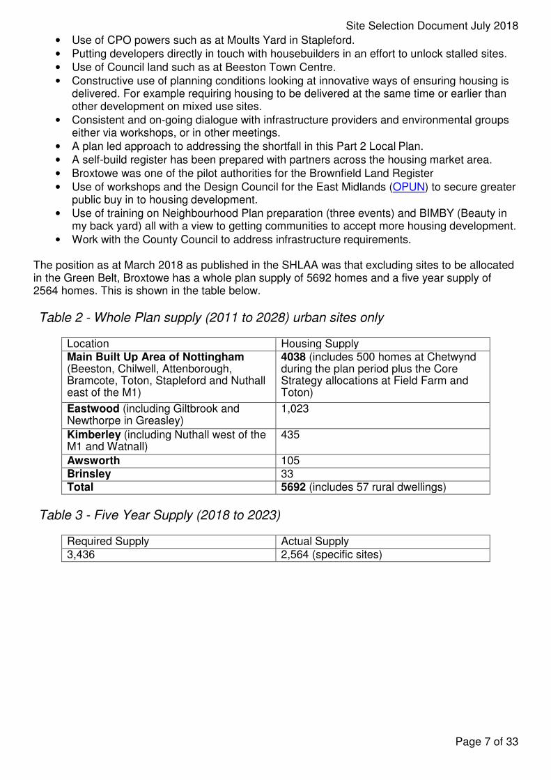
The position as at March 2018 as published in the SHLAA was that excluding sites to be allocated in the Green Belt, Broxtowe has a whole plan supply of 5692 homes and a five year supply of 2564 homes. This is shown in the table below.
Table 2 - Whole Plan supply (2011 to 2028) urban sites only
Location Housing Supply Main Built Up Area of Nottingham (Beeston, Chilwell, Attenborough, Bramcote, Toton, Stapleford and Nuthall east of the M1)
4038 (includes 500 homes at Chetwynd during the plan period plus the Core Strategy allocations at Field Farm and Toton)
Eastwood (including Giltbrook and Newthorpe in Greasley)
1,023
Kimberley (including Nuthall west of the M1 and Watnall)
435
Awsworth 105 Brinsley 33 Total 5692 (includes 57 rural dwellings)
Table 3 - Five Year Supply (2018 to 2023)
Required Supply Actual Supply 3,436 2,564 (specific sites)
Page 7 of 33

Site Selection Document July 2018
Table 4 - Whole Plan supply (2011 to 2028) including Green Belt allocations at the point of adoption of the Local Plan
Location Housing Supply Main Built Up Area of Nottingham (Beeston, Chilwell, Attenborough, Bramcote, Toton, Stapleford and Nuthall east of the M1)
4829 (includes 500 homes at Chetwynd during the plan period plus the Core Strategy allocations at Field Farm and Toton and the Part 2 Local Plan allocations at Bramcote and Stapleford)
Eastwood (including Giltbrook and Newthorpe in Greasley)
1,023 (includes revised delivery assumptions at Walker Street following more detailed discussions with the County Council)
Kimberley (including Nuthall west of the M1 and Watnall)
532 (includes the allocation at Kimberley Depot including Kimberley Caravans)
Awsworth 355 (Includes the allocation west of the village inside the bypass)
Brinsley 153 (includes the allocation east of Church Lane)
Total 6949 (includes 57 rural dwellings)
Table 5 - Five Year Supply (2018 to 2023)
Required Supply Actual Supply 3,436 3,716 (Specific Sites)
The housing delivery anticipated during the whole plan period at Broxtowe is on page 79 of the Plan (in the trajectory) and this shows total housing completions between 2011 and 2028 of 7249 which includes a windfall allowance of 300 in total for the final 5 years of the plan which is consistent with the Core Strategy.
Figures from the SHLAA (updated for the submission of this Local Plan) is that for the five year supply the requirement is 430 x 5 = 2150 to which needs to be added a 20% buffer (raising the figure to 2580) and applying the under-delivery of 856 from the early years of the plan. This gives a total requirement of 3436
Anticipated annual delivery in year order between 2018 and 2023 is 293, 557, 1079, 1019, and 768 giving a supply of 3716. A lapse rate of sites with planning permission needs to be applied and in Broxtowe this is linked to previous years’ lapse rate which is 9% which reduces the figure by 334, and a small windfall allowance is made in line with evidence on historic delivery of small sites (40 a year giving 200 in total). The supply therefore amounts to 3582.
The five year supply taking into account the Green Belt sites to be allocated in this plan is therefore 3582/3436 *5 = 5.2 years with a surplus of 146 homes.
The sites that are delivering housing into the later years of the plan beyond the five year supply period include sites such as Boots, Chetwynd, Beeston Business Park and numerous others as well and it is these sites being built beyond the five year period that are contributing to the overprovision for the whole plan period. This gives a total housing completion figure of 7249 which is a surplus for the whole plan period of 1099 homes or 18%, and to have overall delivery figures exceeding the minimum by 18% gives a sensible and proportionate buffer (additional to that required by the NPPF) taking into account risks to delivery over the whole plan period. The Broxtowe Local Development Scheme also has a review of the Part 1 Local Plan (the Aligned Core Strategy) to be adopted in December 2021 which will address the issue of revised housing
Page 8 of 33
Site Selection Document July 2018
need and its delivery over the whole housing market area and gives nearly 7 years from adoption before the expiry of the end date of this Part 2 Local Plan.
All of the sites assessed through the SHLAA process are deliverable housing sites which have been assessed in most cases via a planning application process and in SA terms amount to sustainable development. The only urban sites that are rejected are ones that have a constraint so severe that they are undeliverable. Following this process more sites are needed which in Broxtowe are all in the Green Belt. As a result of the process described in the remainder of this report the housing supply figures anticipated at the point of adoption of the Local Plan which includes the proposed Green Belt release sites is given below.
Harm specific to the Green Belt and the extent to which the harm can be ameliorated There has been substantial background work to inform the ACS which remains relevant. Tribal Urban Studio were commissioned by the Greater Nottingham Councils to undertake two studies firstly into an appraisal of sustainable urban extensions which focussed on strategic sites on the edge of the main built up area of Nottingham, and secondly on strategic locations for growth on the edge of various sustainable settlements. In addition Broxtowe, Gedling and Nottingham Councils prepared a Green Belt Review Background Paper to inform the Core Strategy examination. Taking into account this background work, Broxtowe has worked collaboratively with Councils across the HMA to develop a shared methodology for undertaking a Green Belt Review (the Green Belt Review Framework). This work was undertaken in 2014 and was published and consulted on in February 2015. Areas around the main built up area of Nottingham and the four key settlements were identified
Page 9 of 33
Site Selection Document July 2018
The Green Belt issues comprise an assessment of the five purposes of including land in the Green Belt which are:
• To check the unrestricted sprawl of large built up areas,
• To prevent neighbouring towns from merging into one another,
• To assist in safeguarding the countryside from encroachment,
• To preserve the setting and special character of historic towns,
• To assist in urban regeneration, by encouraging the recycling of derelict and other urban land.
Each site selected outside of settlement boundaries has been selected on the basis of its lesser impact on the purposes of including land in the Green Belt when compared to alternatives. These site specific issues together with the need for new homes outside of settlement limits, and development amounting to sustainable development amount to the exceptional circumstances to justify Green Belt boundary change. All site selection decisions involving Green Belt boundary change are consistent with recommendations in the two Tribal Reports and the more detailed Green Belt review background evidence to inform the Core Strategy and this Part 2 Local Plan.
Sustainability Appraisal The allocations are selected on the basis on the 14 criteria in the Sustainability Appraisal, and on Green Belt and delivery issues. The sustainability criteria are listed below:
• Housing,
• Health,
• Heritage,
• Crime,
• Social,
• Biodiversity and Green Infrastructure,
• Environment and Landscape,
• Natural Resources and Flooding,
• Waste,
• Energy and Climate Change,
• Transport,
• Employment,
• Innovation,
• Economic Structure. The Sustainability Appraisal (main report, part 1 and part 2) includes details of the sites to be allocated and reasonable alternatives. The sustainability appraisal work has been informed by detailed design review assessments: Awsworth, Bramcote, Brinsley, Chetwynd Barracks, Eastwood, Kimberley, and Nuthall; landscape character appraisal: Part 1, Part 2 and Addendum; equalities assessments and infrastructure delivery planning. The selected sites amount to sustainable development which compare favourably for allocation when compared to reasonable alternatives.
The reasonable alternatives to sites selected are those sites assessed through the SHLAA as being deliverable.
Infrastructure Delivery Plan including viability The selected sites are deliverable. They have been subjected to detailed scrutiny including an Infrastructure workshop with details in the Infrastructure Delivery Plan (IDP). The viability evidence to inform the examination is being updated and will be available in final form by September 2018.
Page 10 of 33
Site Selection Document July 2018
Public Participation The Council has liaised closely with duty to cooperate partners and others in selecting sites with further details in the Council’s Consultation Statement.
Through earlier stages of plan preparation requests were received from Historic England and Ashfield regarding site selections at Brinsley and from Nottingham City Council regarding site selections at Nuthall. The details are in the consultation statement and their requests were agreed to.
There are ten Neighbourhood Plans underway in Broxtowe and in general terms Broxtowe have worked successfully with the Parish and Town Councils and Neighbourhood Forums to achieve the best outcomes for the individual areas. A sequence of workshops were held during 2016 when all preparing Neighbourhood Plans participated and significant efforts have been made to accommodate the wishes of those preparing plans where it is possible to do so.
Conclusion The need for new homes remains as specified in the Core Strategy, the Council has maximised to the greatest possible extent the supply of sites in existing urban areas with an emphasis on the most sustainable and deliverable locations in the urban south of Broxtowe. When sites currently in the Green Belt are selected, there is a comprehensive programme of public participation, rigorous sustainability appraisal, detailed assessment of delivery and significant efforts including through design review to achieve the best outcomes for the whole Borough and especially the individual communities affected.
Site Details The remainder of this report provides a more detailed assessment of the sites recommended to be released from the Green Belt including the HS2 Strategic Location for Growth, Chetwynd and Walker Street, on the grounds that the remaining allocations within the urban area are in line with the already approved strategy in the Core Strategy of urban concentration with regeneration, are deliverable for the numbers of homes proposed during the plan period as indicated in the SHLAA, and follow the requirements that are still fit for purpose when these sites were originally allocated in 2004. The following assessment take into account the responses to the workshops held during 2016, earlier rounds of consultation, including comments made from a variety of statutory consultees, discussions with those preparing neighbourhood plans where a relevant body has been designated for this purpose, the design review work undertaken and delivery issues.
Page 11 of 33
Site Selection Document July 2018
Chetwynd Barracks Site details (SHLAA 193) 91.5 ha previously developed site within the Main Built up Area in two separate ownerships. 75 ha is owned by the Defence Infrastructure Organisation (DIO) who is an operating arm of the Ministry of Defence (MOD). Remainder of the site is within the control of Annington Estates. The site is currently operational but its closure in 2021 has been announced by Ministers. Planning Status No planning application submitted. However, the agents acting on behalf of the landowner have been engaging in on-going active discussions with Broxtowe Borough Council, the Neighbourhood Planning Forum for the area and other key stakeholders including the County Council (with regards to highways requirements). Technical work submitted with representations includes:
• Transport and movement; • Flood risk and surface water drainage; • Ecology; • Air Quality; • Ground Conditions; • Utilities and Services; • Heritage; and • Retail Need and Impact.
Site is included in the Brownfield Land Register and may be considered for Permission in Principle (PIP). Viability Evidence to inform the ACS (Three Dragons, and GL Hearn) concluded that where very large sites are released (several hundred houses), these sites will have the potential to create their own market, which in many instances will exceed the prices being charged for new housing being on smaller sites. The evidence also suggests that in the higher sub-markets (which would include this area) the site should generate robust residual values up to and beyond 30% affordable housing. Applicant has referenced the strong housing market within their submissions and has raised no viability issues.
A plan-wide viability assessment is nearing conclusion. Steps to accelerate delivery Delivery is constrained by current occupation of the land by the MOD. There is the potential for a phased release in line with comprehensive masterplanning.
Delivery assumptions
Page 12 of 33
Site Selection Document July 2018 The ‘Non-Technical Sustainability Appraisal and Development Delivery Statement’ submitted by JLL on behalf of the DIO in November 2017 stated that:
“JLL considers that the strong market location of the site and the potential scale of the proposed development will enable this higher rate (i.e. 100 houses per annum) to be hit reasonably quickly after the commencement of development and maintained thereafter. Moreover, there is sufficient time to secure outline planning permission and to procure a developer in order to commence on site once the Site becomes available (in 2021). JLL foresees also that the first phase of 500 houses will see two developers building out at the same time”. This is consistent with the Assumptions published in the SHLAA. It is expected that the planning application will be with Broxtowe Borough Council for consideration prior to the site being released for development in 2021. This would give 2 years (from the date that the barracks is released for development) before delivery is expected on site.
Delivery on the site is expected to happen in phases with the first phase containing the 500 homes on the western portion of the site (which is largely currently undeveloped) which is expected to be delivered within the plan period. Later phases (to the east) are the more complex to deliver because of the heritage and land use constraints but these are not expected to be delivered within the plan period in any event.
11-12
12-13
13-14
14-15
15-16
16-17
17-18
18-19
19-20
20-21
21-22
22-23
23-24
24-25
25-26
26-27
27-28
100 100 100 100 100
Key Development Requirements: New and Existing Homes:
• 500 Homes (within the plan period), with the capacity for 1,500 overall.
• Ensure that new development integrates with any retained MOD residential accommodation to the north of the site.
Connections and Highways:
• Provide attractive and convenient walking and cycling routes through the site connecting to the proposed HS2 station, the tram and to other recreational routes and nearby facilities.
• Provide a bus route through the site.
• Upgrade existing access points and road network within the site, with Chetwynd Road to be prioritised for buses, cyclists and pedestrians.
• Ensure that the ability to provide a North/South road to link to the Tram Park and Ride site is facilitated by development.
• Highway infrastructure must be considered in conjunction with requirements for the Toton Strategic Location for Growth and wider area as progressed through the Gateway Study and transport modelling.
Green Infrastructure, Open Space and Sports Pitches:
• Retain and enhance Green Infrastructure corridors around the eastern and northern areas of the site and create attractive links between open spaces.
• Retain and enhance the existing playing fields and sports facilities (including the pavilion) on the south eastern corner of the site.
• Retain existing mature trees and grass verges and incorporate these into a boulevard approach to the street scene.
• Retain existing Hobgoblin Wood.
• Ensure that management of woodland, green infrastructure and open spaces are secured in perpetuity.
• Provision of on-site sustainable drainage system.
Page 13 of 33
Site Selection Document July 2018
New facilities:
• Provide a new Primary School and Medical Centre within close proximity to the playing pitches and sports facilities at the south east of the site.
• Provide small retail/service centre to meet local need along the main through route.
• Provision of small scale employment development.
Heritage:
• Provide public access to the Listed Memorial to workers of National Filling Factory No.6, provide public space to the south of the memorial and retain/enhance the existing memorial garden.
• Retain and re-use existing military buildings (non-designated heritage assets) where possible, if not possible, the development should be designed to incorporate the existing footprint of the building into the development layout. (Previously a Key Development Aspiration - now a Key Development Requirement)
Sustainability Appraisal
• This allocation has significant housing, health and transport objectives benefits, and positive effects across most objectives, with no significant negative effects.
• Exceptional circumstances for Green Belt release
• None needed (urban site).
• Infrastructure delivery issues
• Work underway in relation to highways and the potential for contamination. No unresolvable issues.
Page 14 of 33
Site Selection Document July 2018
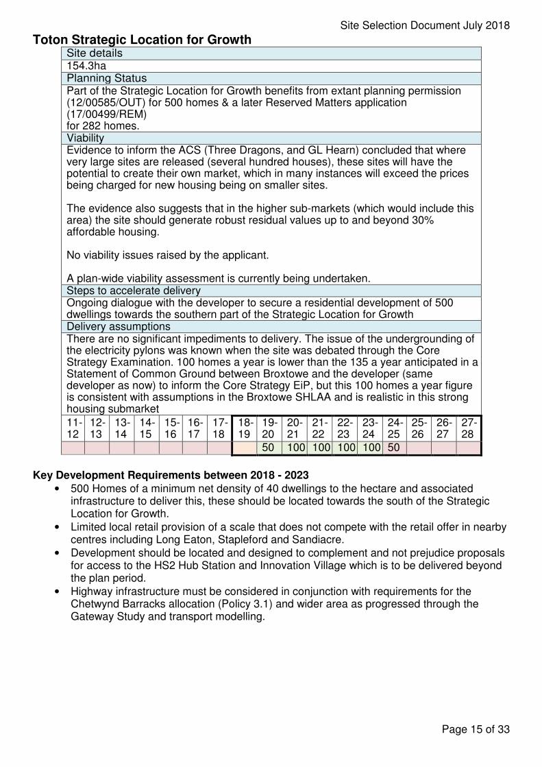
Toton Strategic Location for Growth Site details 154.3ha Planning Status Part of the Strategic Location for Growth benefits from extant planning permission (12/00585/OUT) for 500 homes & a later Reserved Matters application (17/00499/REM) for 282 homes. Viability Evidence to inform the ACS (Three Dragons, and GL Hearn) concluded that where very large sites are released (several hundred houses), these sites will have the potential to create their own market, which in many instances will exceed the prices being charged for new housing being on smaller sites.
The evidence also suggests that in the higher sub-markets (which would include this area) the site should generate robust residual values up to and beyond 30% affordable housing.
No viability issues raised by the applicant.
A plan-wide viability assessment is currently being undertaken. Steps to accelerate delivery Ongoing dialogue with the developer to secure a residential development of 500 dwellings towards the southern part of the Strategic Location for Growth Delivery assumptions There are no significant impediments to delivery. The issue of the undergrounding of the electricity pylons was known when the site was debated through the Core Strategy Examination. 100 homes a year is lower than the 135 a year anticipated in a Statement of Common Ground between Broxtowe and the developer (same developer as now) to inform the Core Strategy EiP, but this 100 homes a year figure is consistent with assumptions in the Broxtowe SHLAA and is realistic in this strong housing submarket
11-12
12-13
13-14
14-15
15-16
16-17
17-18
18-19
19-20
20-21
21-22
22-23
23-24
24-25
25-26
26-27
27-28
50 100 100 100 100 50
Key Development Requirements between 2018 - 2023
• 500 Homes of a minimum net density of 40 dwellings to the hectare and associated infrastructure to deliver this, these should be located towards the south of the Strategic Location for Growth.
• Limited local retail provision of a scale that does not compete with the retail offer in nearby centres including Long Eaton, Stapleford and Sandiacre.
• Development should be located and designed to complement and not prejudice proposals for access to the HS2 Hub Station and Innovation Village which is to be delivered beyond the plan period.
• Highway infrastructure must be considered in conjunction with requirements for the Chetwynd Barracks allocation (Policy 3.1) and wider area as progressed through the Gateway Study and transport modelling.
Page 15 of 33
Site Selection Document July 2018
Key Development Requirements for the Strategic Location for Growth stretching significantly beyond the end of this Part 2 Local Plan The development of an innovation village comprising the following minimum and to be confirmed as part of the review of the Greater Nottingham Aligned Core Strategies:
Community Provision
• Provide space for provision of an expanded or potentially relocated George Spencer Academy including a new Primary School.
• Provide space for provision of a relocated leisure hub with space for a leisure centre including indoor sports centre and 25m swimming pool and outdoor sports pitches.
• Provide a new community centre.
• Provide a new health centre.
• Provide a new neighbourhood scale retail centre.
Traffic / Transport / Connectivity
• A system that flows well for all modes of transport including a multi modal transport hub adjacent to the station and proper consideration of access both from Long Eaton and Stapleford, and how the HS2 site will connect and complement development at the Chetwynd Barracks site. As a minimum this will include good connectivity for cycling and pedestrians from the northern end of Chetwynd Barracks to access the tram and HS2 station via a network of interconnected Green Infrastructure. It will also enable the provision of high quality transport links to the other nearby centres in Broxtowe and Erewash, the three city centres of Derby, Leicester and Nottingham, the airport and strategic rail connected development at Roxhill in Leicestershire to the south and towns in East Derbyshire and West Nottinghamshire to the north.
• Maximise the potential for trips to and beyond the station to be achieved through non-private car modes of transport. This should include:
• Tram extension to HS2 station which should be high level access and complete prior to the opening of the station. It should be designed in such a way as to allow for its potential expansion to Long Eaton, Derby and East Midlands Airport. This will need to include a bridge over the station of sufficient size to accommodate different modes of transport which in addition to the tram would be bus, car, cycle and pedestrian.
• Safe and attractive pedestrian and cycling links between new and existing communities including Toton, Long Eaton, Stapleford and Sandiacre utilising attractive routes though the location to the HS2 hub and neighbouring areas.
• A hierarchy of attractive routes and interconnected places should be created. Green routes should be provided and, where necessary, preserved and enhanced to assist with this including the Erewash Valley/Canal and additional green space to the north of existing settlements at Toton and Chilwell and to the south of Stapleford.
• Pedestrian access should be provided to the station from the east with an additional secondary western access. This should include a safe route either over or under the station.
• In terms of cycling provision, development should be compatible with future north-south and east-west segregated cycle routes. Cycling should be made a viable option for accessing the hub from within a five mile radius. NET extensions should incorporate a tram-side shared path (to extend to Derby if the tram is extended this far).
• Bessell Lane should be incorporated in plans to access the station and significant improvements will need to be made to the quality of the public realm to encourage better connections to Stapleford Town Centre and to assure the quality of the cycling provision on this north-south route including extension of Midland Street, Long Eaton. On a wider scale the plan to open Bennerley Viaduct should be taken into account with its potential to create wider major leisure routes attracting visitors to use Toton Hub as a starting point for cycling tours. A link should be provided to national cycle route 6 along the Erewash Canal directly to the HS2 Hub station and cycle storage should be provided at the station.
Page 16 of 33
Site Selection Document July 2018
• Private vehicle access to the station to be provided via the A52, terminating in ideally underground parking or failing this a multi-storey car park to serve the station.
• Good quality transport links from the HS2 station to nearby town centres including a north/south link road to provide local vehicle, walking and cycling access to the station and to facilitate through bus services.
• Onward rail service connections to other principal East Midlands Stations including Ilkeston Station.
• The provision of a comprehensive and well contained transport interchange in very close proximity to the station and ideally being contained entirely on HS2 operational land.
• Prevent overspill parking in existing residential areas when the station is operational. This may include Toton to become ‘residents only parking’ area to mitigate issues with Station/Tram traffic.
Green Infrastructure
• Extensive multi-purpose interconnected Green Infrastructure routes to be provided to connect areas of growth and existing communities all of which should be of sufficient width and quality to provide attractive and usable links in the following locations:
• Along the southern boundary of the location north of existing communities of Toton and Chilwell, between Hobgoblin Wood in the east and Toton Fields Local Wildlife Site in the west, this will be a significant corridor in the area, and should incorporate both pedestrian and cycle access to HS2 station;
• Along the northern boundary of the location south of Stapleford this should comprise a narrow, graded tree and shrub roadside corridor to improve screening of the Innovation Village from the A52;
• Along the Erewash Canal to the west of the location (incorporating flood mitigation on the low lying Sidings part of the site) and Erewash River (between Toton Washlands and Stapleford);
• Along a north/south corridor immediately to the west of Toton towards Bessell Lane.
• A new primary route through the centre of the location linking development areas to the HS2 Hub linking to a high quality ‘station square’ as part of a new attractive principal pedestrian route.
• No loss of trees which are the subject of Tree Preservation Orders and extensive additional planting to be undertaken at appropriate locations to enhance provision of wildlife corridors of varying widths.
• Multi use sporting provision should be provided in appropriate locations ideally adjacent to the school for use by school children and others.
Economic development
• The creation of an innovation village as part of a mixed use development to provide significant numbers of new high skilled jobs to drive economic development in the immediate area and the wider region.
• The provision of iconic tall buildings in close proximity to the station and on the western edge of the higher land further west. This is to provide suitable premises for economic ambitions to be met in a flexible format to allow for, and encourage, a mix of uses and also to provide a visual link to the northern gateway of the site leading to Stapleford District Centre and in doing so encourage additional investment in, and enhancements to, Stapleford District Centre.
• This development may include large scale conferencing facilities, university research/development provision, possible potential for hotels and other high tech developments seeking premises in proximity to a HS2 station.
School / Leisure
• Option to provide space on the eastern side of Toton Lane for a ‘South Broxtowe Leisure
Page 17 of 33

Site Selection Document July 2018
Hub’, if required. This would include a new Leisure Centre and associated indoor and outdoor facilities and a relocated GSA School campus.
Land Assembly
• Provide a school site of sufficient scale to accommodate the full educational needs of 3 to 18 year olds at George Spencer Academy within the strategic location and potentially as part of a school/leisure hub on the eastern side of Toton/ Stapleford Lane.
• Relocate the plant nursery, electricity substation, sewage works and Network Rail/ DB Schenker off site.
Given the strategic significance of this location on transport and economic grounds, and the length of time it will take to deliver in its entirety, the single most important issue in this Part 2 Local Plan is that development in this location makes positive provision for the development of the whole strategic location by 2028 and does not conflict or compromise the wider development of this strategic location.
This can be done in securing the delivery of the 500 homes and supporting infrastructure in the early years of the Part 2 Local Plan in line with the wider growth strategy work being undertaken over a much wider area.
Sustainability Appraisal
• The ‘Toton Strategic Location for Growth’ site is confirmed, as the Broxtowe Core Strategy stated previously, as highly sustainable, in part as a result of its large size. It strategically meets the housing and health objectives, and, has major positive economic, innovation and transport effects, the latter being of national significance. However, the negative effects mainly arise also from the scale of the proposed development which will strategically change the green outlook and landscape, but this may be mitigated by new green infrastructure and exemplary design of development.
Exceptional circumstances for Green Belt release
• The Inspector into the ACS was content that the exceptional circumstances had been demonstrated as was the High Court Judge (Judge Jay) in ruling on the legal challenge into the ACS. There has been no change of circumstances since this time to justify a different view being taken.
Infrastructure delivery issues
• Work largely resolved for the delivery of the 500 homes and supporting infrastructure determined as part of the outline planning application. Severn Trent has noted that it is likely that a capital scheme would be required for a new gravity sewer to take foul flow from the site to the Stapleford STW and also that if foul flows were to be discharged to the south, then due to the topography, a pumping station might be required. Significant work is currently underway to ensure the delivery of significant additional development beyond this plan period.
Page 18 of 33
Site Selection Document July 2018
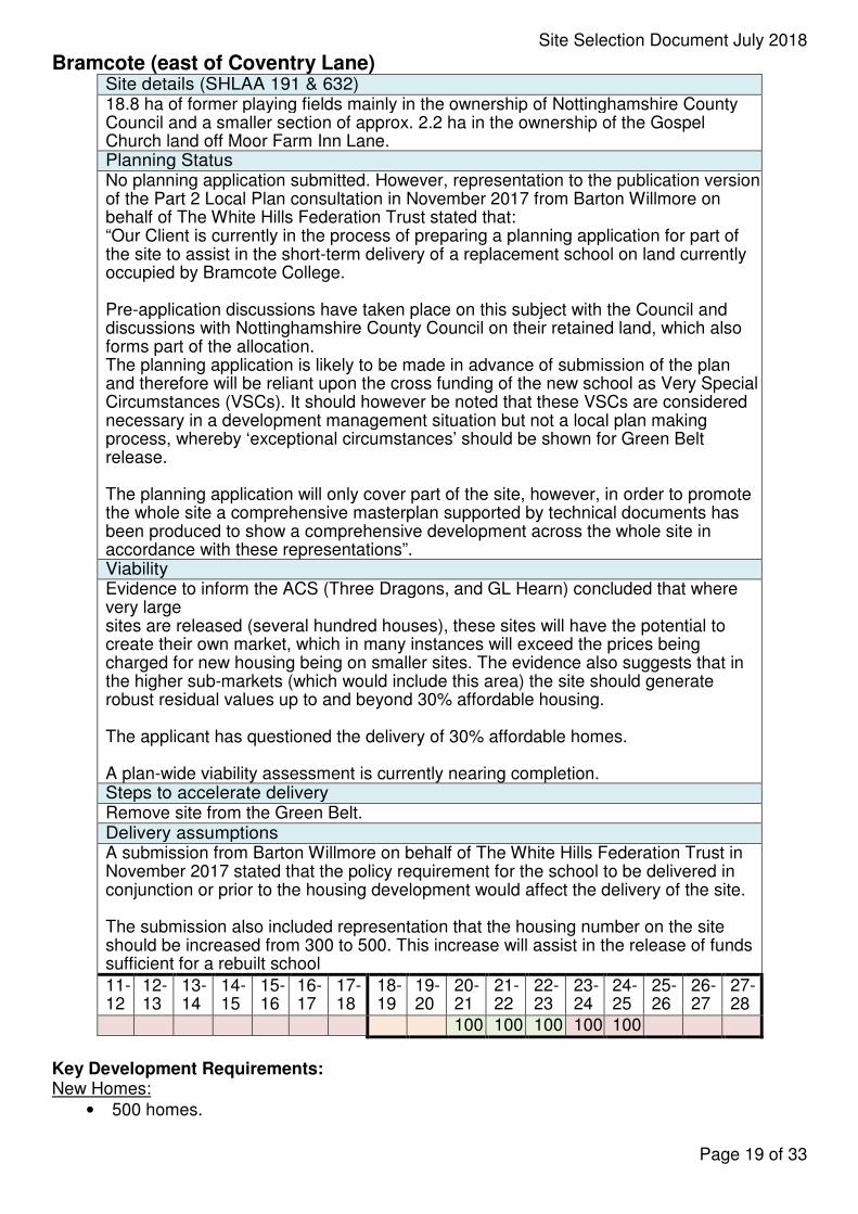
Bramcote (east of Coventry Lane) Site details (SHLAA 191 & 632) 18.8 ha of former playing fields mainly in the ownership of Nottinghamshire County Council and a smaller section of approx. 2.2 ha in the ownership of the Gospel Church land off Moor Farm Inn Lane. Planning Status No planning application submitted. However, representation to the publication version of the Part 2 Local Plan consultation in November 2017 from Barton Willmore on behalf of The White Hills Federation Trust stated that: “Our Client is currently in the process of preparing a planning application for part of the site to assist in the short-term delivery of a replacement school on land currently occupied by Bramcote College.
Pre-application discussions have taken place on this subject with the Council and discussions with Nottinghamshire County Council on their retained land, which also forms part of the allocation. The planning application is likely to be made in advance of submission of the plan and therefore will be reliant upon the cross funding of the new school as Very Special Circumstances (VSCs). It should however be noted that these VSCs are considered necessary in a development management situation but not a local plan making process, whereby ‘exceptional circumstances’ should be shown for Green Belt release.
The planning application will only cover part of the site, however, in order to promote the whole site a comprehensive masterplan supported by technical documents has been produced to show a comprehensive development across the whole site in accordance with these representations”. Viability Evidence to inform the ACS (Three Dragons, and GL Hearn) concluded that where very large sites are released (several hundred houses), these sites will have the potential to create their own market, which in many instances will exceed the prices being charged for new housing being on smaller sites. The evidence also suggests that in the higher sub-markets (which would include this area) the site should generate robust residual values up to and beyond 30% affordable housing.
The applicant has questioned the delivery of 30% affordable homes.
A plan-wide viability assessment is currently nearing completion. Steps to accelerate delivery Remove site from the Green Belt. Delivery assumptions A submission from Barton Willmore on behalf of The White Hills Federation Trust in November 2017 stated that the policy requirement for the school to be delivered in conjunction or prior to the housing development would affect the delivery of the site.
The submission also included representation that the housing number on the site should be increased from 300 to 500. This increase will assist in the release of funds sufficient for a rebuilt school
11-12
12-13
13-14
14-15
15-16
16-17
17-18
18-19
19-20
20-21
21-22
22-23
23-24
24-25
25-26
26-27
27-28
100 100 100 100 100
Key Development Requirements: New Homes:
• 500 homes.
Page 19 of 33
Site Selection Document July 2018
Connections and Highways:
• Incorporate design measures to slow the speed of traffic on Coventry Lane.
• Provide safe pedestrian and cycling routes including crossing points on surrounding roads linking to the redeveloped school, the development on the western side of Coventry Lane in Stapleford and the Erewash Valley Trail.
• Vehicular access to the site shall only be via Coventry Lane and should be via a single junction which serves both allocations Policy 3.3 (East of Coventry Lane Bramcote) and Policy 3.4 (West of Coventry Lane Stapleford).
• Enhance bus routes adjacent to the site.
Green Infrastructure and Sports Pitches:
• Provide enhanced Green Infrastructure corridors linking urban areas of Nottingham to the east with Bramcote and Stapleford Hills, Bramcote Park, Boundary Brook, Pit Lane Wildlife Site, Nottingham Canal and Erewash Valley Trail in the west.
• Ensure that any loss of the Local Wildlife Site land is mitigated/compensated at equivalent quality within close proximity to its current location.
• Development should not prejudice the use of the existing sports facilities at Bramcote School or Leisure Centre.
New facilities:
• Provide a replacement school at a location south of the ridgeline, the ridge should be kept free of built development (within the outline shown on page 45).
• School redevelopment is to be delivered in conjunction with or prior to housing development (within the outline shown on page 45) and no houses are to be occupied until the school is substantially complete.
Heritage:
• Remove vegetation from the sandstone cutting off Moor Lane in a way that does not compromise its stability.
Sustainability Appraisal
• This allocation has significant housing and health objective benefits with only one negative effect due to the Bramcote Moor Grassland LWS designation, albeit that the area of interest of this designation only covers a very small area.
Exceptional circumstances for Green Belt release
• The areas at the north of the site bounded by the railway line/ Coventry Lane to the west/ the ridge to the south , and urban areas within Bramcote to the east perform well when assessed against the five purposes of including land in the Green Belt
• The housing requirements cannot be met without some Green Belt release and Bramcote is one of the best performing sites in the SA
• Bramcote is one of the highest value areas in the Borough of Broxtowe which means that development in Bramcote can secure greater public benefits from development than elsewhere
• Two of the most immediate public benefits are the provision of 30% affordable housing in an area of high affordable housing need and a complete redevelopment of the School
• Immediate access to large areas of attractive green infrastructure with health benefits for new and existing residents, but making such assets more accessible, particularly in traffic measures on Coventry Lane with a view to slowing cars down and making it safer to cross the road.
Infrastructure delivery issues
• Work underway regarding transport and other infrastructure. No unresolvable issues.
Page 20 of 33
Site Selection Document July 2018
Vehicle access to this site and to the Land West of Coventry Lane site to be both via a single junction on Coventry Lane.
Page 21 of 33
Site Selection Document July 2018
Stapleford (west of Coventry Lane) Site details 12.2 ha within 3 different ownerships; Broxtowe Borough Council, J McCann & Co (Nottingham) Ltd and the Rogers Family.
Planning Status No planning application submitted. Viability
Evidence to inform the ACS (Three Dragons, Golland and GL Hearn) concluded that where very large sites are released (several hundred houses), these sites will have the potential to create their own market, which in many instances will exceed the prices being charged for new housing on smaller sites.
The evidence also suggests that in the higher sub-markets (which would include this area) the site should generate robust residual values up to and beyond 30% affordable housing.
No viability issues raised by the applicant.
A plan-wide viability assessment is currently being undertaken. Steps to accelerate delivery
Remove site from the Green Belt.
Delivery assumptions
A submission by Planning and Design Group on behalf of J McCann gave no specific delivery timescale for the site but did set out expectation that it would be delivered within the plan period.
A submission by GraceMachin Planning and Property on behalf of the Rogers Family stated that the site is deliverable in the short term.
11-12
12-13
13-14
14-15
15-16
16-17
17-18
18-19
19-20
20-21
21-22
22-23
23-24
24-25
25-26
26-27
27-28
100 100 40
Key Development Requirements: New Homes:
• 240 homes.
Connections and Highways:
• Provide safe pedestrian and cycling routes including crossing points on surrounding roads linking to the redeveloped school, the development on the eastern side of Coventry Lane in Bramcote, the Field Farm development and the Erewash Valley Trail.
• Vehicular access to the site shall only be via Coventry Lane and should be via a single junction which serves both allocations Policy 3.3 (East of Coventry Lane Bramcote) and Policy 3.4 (West of Coventry Lane Stapleford).
• Incorporate design measures to slow the speed of traffic on Coventry Lane.
• Enhance bus routes adjacent to the site.
Green Infrastructure:
• Provide enhanced Green Infrastructure corridors linking urban areas of Nottingham to the east with Bramcote and Stapleford Hills, Bramcote Park, Boundary Brook, Pit Lane Wildlife Site, Nottingham Canal and Erewash Valley Trail in the west.
• Provide a buffer between the crematorium and Stapleford Hill to ensure tranquil setting of crematorium is not compromised and ensure the new housing will not be in shade for extended periods of time due to the proximity of Stapleford Hill.
Page 22 of 33
Site Selection Document July 2018
Sustainability Appraisal
• This allocation has significant housing and health objectives benefits with only one negative effect on the biodiversity and green infrastructure objective.
Exceptional circumstances for Green Belt release
• The site is bounded by the railway line/ Coventry Lane to the east, Stapleford Hill to the south, and the Field Farm allocation to the west and performs well when assessed against the five purposes of including land in the Green Belt.
• The housing requirements cannot be met without some Green Belt release and Stapleford is one of the best performing sites in the SA.
• The site is in immediate proximity to Bramcote and in sales value terms would be more similar to Bramcote than the built up areas of Stapleford further south. This means that development on this site can secure greater public benefits from development than elsewhere. It is notable that development at Field Farm contained full policy compliant S106 contributions.
• Immediate access to large areas of attractive green infrastructure with health benefits for new and existing residents, but making such assets more accessible, particularly in traffic measures on Coventry Lane and the provision of enhanced crossing points.
Infrastructure delivery issues
• Work underway regarding transport and other infrastructure. No unresolvable issues have been identified. Vehicle access to this site and to the Land East of Coventry Lane site to be both via a single junction on Coventry Lane.
Page 23 of 33
Site Selection Document July 2018
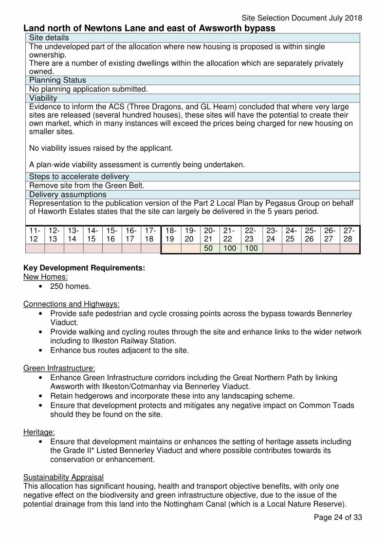
Land north of Newtons Lane and east of Awsworth bypass Site details The undeveloped part of the allocation where new housing is proposed is within single ownership. There are a number of existing dwellings within the allocation which are separately privately owned. Planning Status No planning application submitted. Viability Evidence to inform the ACS (Three Dragons, and GL Hearn) concluded that where very large sites are released (several hundred houses), these sites will have the potential to create their own market, which in many instances will exceed the prices being charged for new housing on smaller sites.
No viability issues raised by the applicant.
A plan-wide viability assessment is currently being undertaken.
Steps to accelerate delivery Remove site from the Green Belt. Delivery assumptions Representation to the publication version of the Part 2 Local Plan by Pegasus Group on behalf of Haworth Estates states that the site can largely be delivered in the 5 years period.
11-12
12-13
13-14
14-15
15-16
16-17
17-18
18-19
19-20
20-21
21-22
22-23
23-24
24-25
25-26
26-27
27-28
50 100 100
Key Development Requirements: New Homes:
• 250 homes.
Connections and Highways:
• Provide safe pedestrian and cycle crossing points across the bypass towards Bennerley Viaduct.
• Provide walking and cycling routes through the site and enhance links to the wider network including to Ilkeston Railway Station.
• Enhance bus routes adjacent to the site.
Green Infrastructure:
• Enhance Green Infrastructure corridors including the Great Northern Path by linking Awsworth with Ilkeston/Cotmanhay via Bennerley Viaduct.
• Retain hedgerows and incorporate these into any landscaping scheme.
• Ensure that development protects and mitigates any negative impact on Common Toads should they be found on the site.
Heritage:
• Ensure that development maintains or enhances the setting of heritage assets including the Grade II* Listed Bennerley Viaduct and where possible contributes towards its conservation or enhancement.
Sustainability Appraisal This allocation has significant housing, health and transport objective benefits, with only one negative effect on the biodiversity and green infrastructure objective, due to the issue of the potential drainage from this land into the Nottingham Canal (which is a Local Nature Reserve).
Page 24 of 33
Site Selection Document July 2018
This could be mitigated by enhanced drainage infrastructure.
Exceptional circumstances for Green Belt release
• The site is bounded by the existing village to the to the east, Newtons Lane and the bypass on other sides and performs well when assessed against the five purposes of including land in the Green Belt.
• The housing requirements cannot be met without some Green Belt release and Awsworth is one of the best performing sites in the SA.
• Significant enhancements are possible to secure the long term up keep of Bennerley Viaduct as a walking and cycling route which is a Grade II* Listed Building.
• Ilkeston Station is within walking distance of the site and new development could make the station more accessible, particularly in traffic measures on the bypass and the provision of enhanced crossing points.
Infrastructure delivery issues
• Work underway regarding transport and other infrastructure. No unresolvable issues have been identified.
Page 25 of 33
Site Selection Document July 2018
East of Church Lane, Brinsley Site details Site is within single ownership Planning Status No planning application submitted. Viability Evidence to inform the ACS (Three Dragons, and GL Hearn) concluded that on smaller sites (tested at 1ha) market selling prices will broadly ‘pick up’ the values from surrounding or very local settlements.
No viability issues raised by the applicant, applicant has confirmed that the 30% affordable housing requirement will be fulfilled.
A plan-wide viability assessment is currently being undertaken. Steps to accelerate delivery
Remove site from the Green Belt.
Delivery assumptions
Representations received to the Publication Version Part 2 Local Plan consultation by Guy Taylor Associates on behalf of Mr and Mrs Anthony state that the site is available now and should be defined as deliverable within 5 years.
11-12
12-13
13-14
14-15
15-16
16-17
17-18
18-19
19-20
20-21
21-22
22-23
23-24
24-25
25-26
26-27
27-28
55 55
Key Development Requirements: New Homes;
• 110 Homes.
Connections and Highways:
• Enhance bus routes adjacent to the site.
• Provide traffic calming measures to reinforce the existing 30mph speed limit on the A608.
Green Infrastructure:
• Enhance Green Infrastructure corridors by linking areas of Brinsley to north and west and D H Lawrence country to the east (including Vine Cottage and routes past the Headstocks to Eastwood).
• Provide SuDS and additional planting to the south of the residential allocation and make this area a publically accessible amenity space.
• Retain hedgerows and incorporate these into any landscaping scheme.
Heritage:
• Conserve the setting of St James the Great Church including open vistas towards the Headstocks.
Sustainability Appraisal This allocation has significant housing and health objective benefits, with the only negative effects being on the landscape objective and the economic structure objective, the latter due to the distance of the settlement of Brinsley from the strategic highway network.
Exceptional circumstances for Green Belt release
• The site is bounded by the urban areas of Brinsley to the north and west, Brinsley Brook to the east and open fields to the south. Enhanced planting in combination with the SuDS feature would be needed to provide a long term defensible boundary at the south of the site.
Page 26 of 33
Site Selection Document July 2018
• The housing requirements cannot be met without some Green Belt release and Brinsley is one of the best performing sites in the SA.
• An enhanced heritage trail can be provided.
Infrastructure delivery issues
• Work underway in relation to highways and other infrastructure. No unresolvable issues have been identified.
Page 27 of 33
Site Selection Document July 2018
Walker Street, Eastwood Site details (SHLAA 138) In single ownership by Nottinghamshire County Council. Planning Status Part allocated for Housing development in the 2004 Local Plan.
13/00784/FUL application for “Construct 113 apartments, 27 bungalows, energy centre and associated access road, car parking, amenity space and landscaping” refused on highways grounds but was allowed at appeal (APP/J3015/W/15/3121591). A S106 agreement was signed and agreed. The permission was conditioned to commence within a year and subsequently lapsed on the 10th November 2016.
A later application (16/00665/CCR) which covered some of the land contained within the above application for the “Erection of a two storey replacement 210 place primary and 26 full time equivalent place nursery school, additional car parking, lighting and CCTV, sports pitch provision and landscaping. Widening of existing vehicular access from Walker Street, reuse of existing pedestrian access points, and provision of new pedestrian access to eastern boundary from Eastwood Public Footpath No. 27. New 2.4m high weldmesh fencing to enclose site in conjunction with retained existing boundary fencing to Walker Street. 3.5m high timber fencing to enclose sprinkler tank / pump house, 2.4m high to foul / surface drainage pumps and bin store. Resurfacing of existing hard court area and enclosure with 3m high weldmesh fencing”. This is under construction and therefore the above scheme cannot be implemented.
The new allocation in the Part 2 Local Plan has reconfigured how the site is envisaged to be developed. The 2004 housing allocation is now protected as open space (the Canyons) and the relocation of the school means that the land previously occupied by a school to the north of the site will be available for development as the new school is open. Viability Evidence to inform the ACS (Three Dragons, Golland and GL Hearn) concluded that where very large sites are released (several hundred houses), these sites will have the potential to create their own market, which in many instances will exceed the prices being charged for new housing on smaller sites.
The evidence also suggests that in the lower sub-markets (which would include this area) the site may be unviable beyond 10% affordable housing.
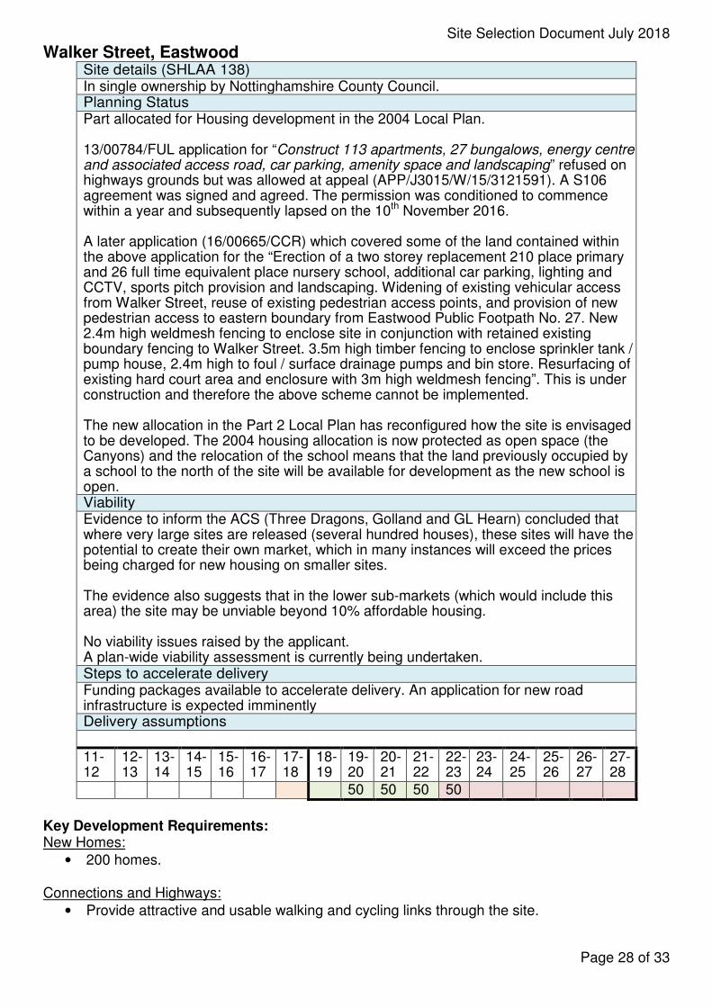
No viability issues raised by the applicant. A plan-wide viability assessment is currently being undertaken. Steps to accelerate delivery Funding packages available to accelerate delivery. An application for new road infrastructure is expected imminently Delivery assumptions
11-12
12-13
13-14
14-15
15-16
16-17
17-18
18-19
19-20
20-21
21-22
22-23
23-24
24-25
25-26
26-27
27-28
50 50 50 50
Key Development Requirements: New Homes:
• 200 homes.
Connections and Highways:
• Provide attractive and usable walking and cycling links through the site.
Page 28 of 33
Site Selection Document July 2018
Green Infrastructure and Open Space:
• Retain ‘the Canyons’ as open space.
• Enhance Green Infrastructure corridors through the site including enhancing the wildlife corridor to the rear of houses on Garden Road and connect to the wider area via the D H Lawrence heritage trail.
• Ensure that development does not increase the risk of flooding elsewhere.
• Provision of SuDS at the northern edge of the site.
Heritage:
• Maintain views of D H Lawrence heritage from Walker Street as part of the D H Lawrence heritage trail.
New Facilities:
• Redevelop Lynncroft Primary school on Walker Street site frontage.
• Provide a 1 acre site at the south west corner of the site for a new community hub including a health facility.
Sustainability Appraisal
• This allocation has significant housing and, in particular, health objectives benefits, with only one negative effect on the landscape objective, principally because of D H Lawrence literary heritage association.
Exceptional circumstances for Green Belt release
• None needed (urban site).
Infrastructure delivery issues
• One of the most significant infrastructure delivery issues in the Eastwood area is the need for education contributions, given the relatively low land values and the viability issues arising from this. The fact that a new school has been provided as part of his development is a significant positive factor in this context. Although affordable housing may not be able to be provided in the same numbers as in the south of Broxtowe, this needs to be seen in the context of the lower land and house prices in Eastwood, the fact that an element of local need may be provided by extra care housing, and the fact that the site is in a highly sustainable location on the edge of Eastwood Town centre, with less requirement for transport contributions because of this. Discussions have taken place with the Nottingham West CCG in relation to the provision of a new community hub including a health facility.
Page 29 of 33
Site Selection Document July 2018
South of Kimberley including Kimberley Depot Site details Multiple land owners with the Borough Council owning the majority and the access. Planning Status No planning application submitted. Viability Evidence to inform the ACS (Three Dragons, Golland and GL Hearn) concluded that on smaller sites (tested at 1ha) market selling prices will broadly ‘pick up’ the values from surrounding or very local settlements.
The evidence also suggests that in the middle-market (which would include this area) the site viability would be much more marginal at 30% affordable housing and therefore 20% affordable housing has been allocated.
No viability issues raised.
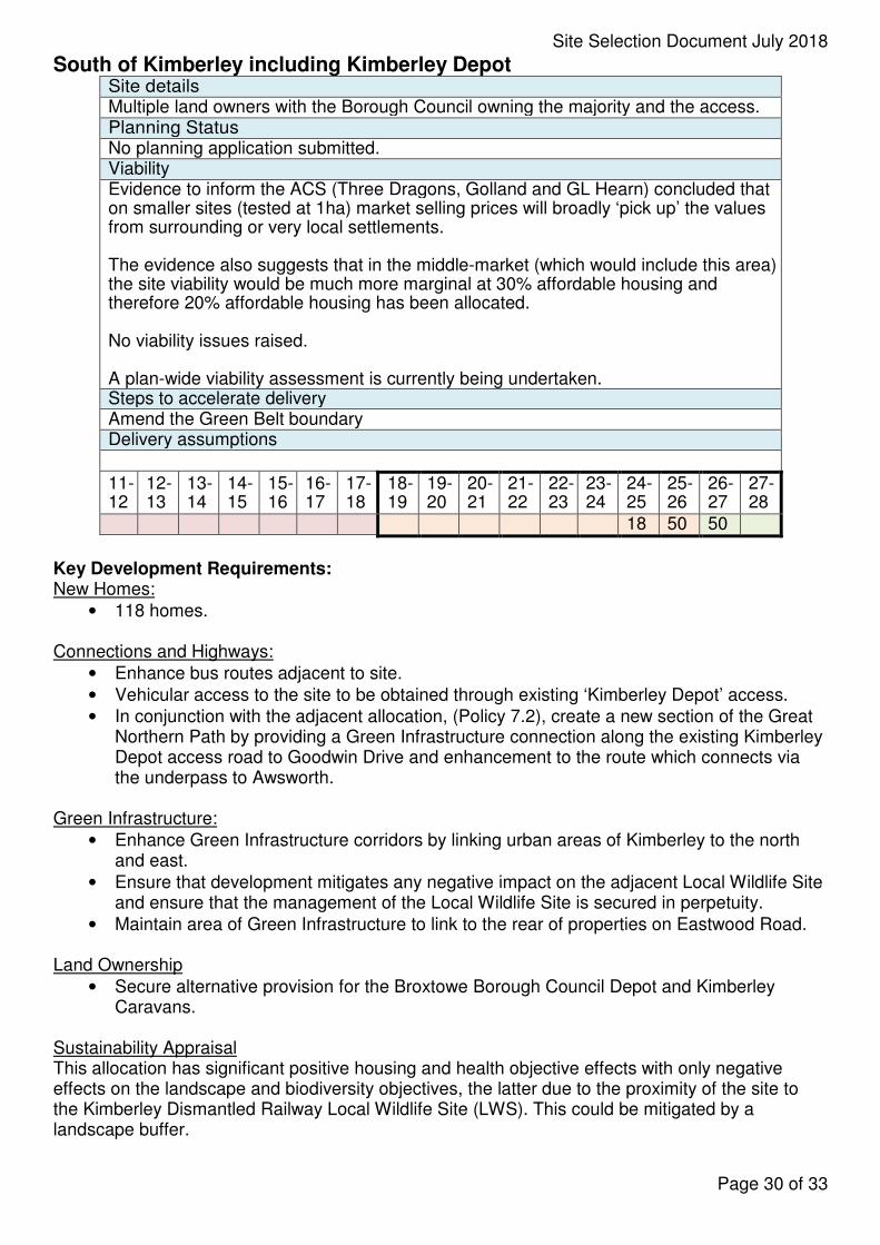
A plan-wide viability assessment is currently being undertaken. Steps to accelerate delivery Amend the Green Belt boundary Delivery assumptions
11-12
12-13
13-14
14-15
15-16
16-17
17-18
18-19
19-20
20-21
21-22
22-23
23-24
24-25
25-26
26-27
27-28
18 50 50
Key Development Requirements: New Homes:
• 118 homes.
Connections and Highways:
• Enhance bus routes adjacent to site.
• Vehicular access to the site to be obtained through existing ‘Kimberley Depot’ access.
• In conjunction with the adjacent allocation, (Policy 7.2), create a new section of the Great Northern Path by providing a Green Infrastructure connection along the existing Kimberley Depot access road to Goodwin Drive and enhancement to the route which connects via the underpass to Awsworth.
Green Infrastructure:
• Enhance Green Infrastructure corridors by linking urban areas of Kimberley to the north and east.
• Ensure that development mitigates any negative impact on the adjacent Local Wildlife Site and ensure that the management of the Local Wildlife Site is secured in perpetuity.
• Maintain area of Green Infrastructure to link to the rear of properties on Eastwood Road.
Land Ownership
• Secure alternative provision for the Broxtowe Borough Council Depot and Kimberley Caravans.
Sustainability Appraisal This allocation has significant positive housing and health objective effects with only negative effects on the landscape and biodiversity objectives, the latter due to the proximity of the site to the Kimberley Dismantled Railway Local Wildlife Site (LWS). This could be mitigated by a landscape buffer.
Page 30 of 33
Site Selection Document July 2018
Exceptional circumstances for Green Belt release (part of site)
• The site is bounded by the urban areas of Kimberley to the north, a dismantled railway line to the south east and the A610 to the south west and performs well when assessed against the five purposes of including land in the Green Belt
• The housing requirements cannot be met without some Green Belt release and Kimberley is one of the best performing sites in the SA
• The allocation is in line with the emerging position in the Kimberley Neighbourhood Plan
• Secure redevelopment of a part previously developed site with the Depot and Caravans site which are to re-locate with no net loss of jobs.
Infrastructure delivery issues
• Work underway regarding transport, re-location of the Depot and Kimberley Caravans and other infrastructure. Potential for contamination as a result of the current use of part of the site as a waste transfer station. No unresolvable issues have been identified.
Page 31 of 33
Site Selection Document July 2018
Employment Provision Policy 4 of the ACS requires provision of 34,000 square metres of office space and 15 hectares of Industrial and Warehousing use. The evidence underpinning this was reviewed in 2015 by Nathaniel Litchfield and these figures remain robust. 34,000 square metres of office space amounts to a land requirement of 8.5 ha based on single storey buildings and 40% plot coverage. In reality the majority of office development will be two storeys or higher, and may well be higher employees density than this with moves towards more flexible working, employees sharing work units, and overall spending less time in the office than a conventional 9 to 5 day. However, to plan for this amount allows for a sensible buffer. There have been net losses of employment land between 2011 and 2018 amounting to 8.7 ha as reported in the Council’s Local Authority Monitoring Reports. In addition further losses of 0.5ha are anticipated during 2018-19, and the total B Class office floorspace needed during this plan period is therefore 32.7ha In line with the strategy of urban concentration with regeneration this can be provided on a selection of urban sites. These include schemes already approved since the adoption of the Core Strategy subject to S106 at Boots and Beeston Business Park (both within the urban south of Broxtowe), at the Mushroom Farm north of Eastwood (Planning Permission in place and removed from the Green Belt as part of the previous Local Plan in 2004), at Chetwynd Barracks which is allocated in this Local Plan, and potentially at the Toton Strategic Location for Growth within this Local Plan period to 2028.
The figures are given below
Mainly manufacturing:
• Mushroom Farm (under construction now) 23.4 ha
• Aerofabrications (3.5ha)
• Beeston Business Park (3.5 ha)
• Boots (cross boundary with Nottingham City and estimate of 2ha employment space within Broxtowe)
Mainly Offices:
• 18,000 sq m of “B-Class employment space”, which would be equivalent to about 4.5 ha at the Toton Strategic Location for growth
• 15,000 sq m of B-Class employment space which would be equivalent to about 3.75 ha at Chetwynd
• A conservative estimate of 5,000 sqm of B class employment space to be provided in the upper floors of underused town centre units, as encouraged by Policy 10 of this Local Plan, at Boots and Beeston Business Park, which each will have an element of office use in addition to manufacturing. (1.25 ha)
In addition Policy 9 of this Part 2 Local Plan contains robust protections for existing good quality employment sites.
Page 32 of 33
Site Selection Document July 2018
Retail Provision The retail need evidence to inform the Core Strategy was reviewed in 2015 by Carter Jonas which found no need for additional out of town retail or a need to expand town centre boundaries. The amendments to town centre boundaries in this Part 2 Local Plan follow consideration of this evidence of need and liaison with the Council’s town centres team to establish appropriate boundaries. The policy intention is to have smaller town centres which are more easily walkable with positive policies to encourage more effective use of upper floors.
Page 33 of 33