site hazard assessment worksheet 1: summary score …
TRANSCRIPT

SITE HAZARD ASSESSMENT
Worksheet 1: Summary Score Sheet
03E
SITE DESCRIPTION
Cleanup Site ID: 6663
Texaco 211577 Monterey
631 Queen Anne Avenue North Section 2525N
Latitude, Longitude: 47.62552 , -122.35706
Tax Parcel ID: 387990-0425, -0435, -0500, -0490, -0640, -0530, -0540
SITE NAME:
on the
The source of contamination for the Texaco 211577 Monterey site (Site) is located on tax parcel 3879900425, on the southwest corner of the intersection of Queen Anne Avenue North and West Roy Street in the Lower Queen Anne neighborhood of Seattle (Figure 1). This parcel includes 0.25 acres of property zoned for mixed use (SM-UP 85 (M1)), and currently houses a vacant retail building and a pay to park lot run by Republic Parking. Contamination of the property occurred during the Site's historical use as a gas station from approximately December 1927 to June 1993.
The configuration of buildings and underground storage tanks (USTs) on the source parcel has changed multiple times since the initial development as a gas station. The station was built in 1927, with redevelopments in 1954 and 1967. See Figure 2 for specific locations of buildings and USTs. Generally, fueling activities have been located on the eastern portion of the parcel, and a retail building has been located in the southern portion of the parcel. The station was decommissioned in 1993. Since that time, the property has housed one building in the southern portion of the parcel. Demolition of this building is planned as part of a proposed site redevelopment into a mixed-use building with retail spaces and apartments.
Contamination has migrated off of the source property onto multiple downgradient parcels that are also considered part of the Site. Current occupants, addresses, and parcel numbers for these properties are included in the next section of this report, and are shown on Figure 3. These include parcels used for both multi-family residential and commercial uses. Contamination has also been detected under West Roy Street and Queen Anne Avenue North, the right-of-ways north and east of the source parcel, as well as under 1st Avenue West. Based on historical sampling locations on the Site, it is possible that contamination above cleanup levels extends onto additional parcels that have not been fully characterized, such as parcels 3879900485 (Alvena Vista Apartments), 3879900570 (Tup Tim Thai restaurant), 3879900580 (Uptown Studios Apartments), and 3879900590 (Chandler Hall Apartments).
SITE REGULATORY HISTORYThis Site was originally two separate cleanup sites. The Monterey Apartments site documents (CSID 4813) included those related to Ecology-led interim remedial activities and site characterization that occurred during this time period. These actions were prompted by vapor intrusion in the apartment building, and began prior to the source of contamination being identified. In 2001, consent decrees between Ecology and both the Arnolds and Texaco were used to reclaim past Ecology costs related to interim remedial actions at this site. The Arnolds and Texaco were identified as potentially liable persons (PLPs) in 1994 and 1999, respectively.
The Texaco 211577 site documents (CSID 6663) related to both the source parcel (3879900425) and to all the off-property parcels included in the Site, and covered independent cleanup activities that were not part of Ecology's interim remedial actions. The Texaco 211577 site was enrolled in Ecology's Voluntary Cleanup Program (VCP) from 2002 to 2015 under VCP number NW0911. Chevron, the corporate successor to Texaco,
Seattle, King County, WA 98109
Facility/Site ID: 77774779 August 2019
Rank: 1
LOCATION OF SITE
Hazardous Sites List.
Within Currently Defined Site Boundaries
Township , ,Range
Completed on 5/7/2019 for inclusion

SITE HAZARD ASSESSMENT
Worksheet 1: Summary Score Sheet
was the VCP customer during this time period.
The Texaco site briefly reentered VCP in 2018-2019 under VCP number NW3197 and proposed an interim remedial action on the source parcel as part of upcoming redevelopment activities on the Site. At this point Roystone on Queen Anne LLC (Roystone) was the VCP customer. A full file review led to the determination that the site was too complex for VCP and that cleanup should proceed under Ecology supervision. Ecology determined that Roystone was a PLP for the Site in 2019, and negotiations for an Agreed Order between Ecology, Chevron, and Roystone are currently underway. To better reflect the Site boundaries based on Ecology's current knowledge of the Site and the areas to be covered under the proposed Agreed Order, the two existing sites were administratively combined into the Texaco 211577 Monterey Site in April 2019.
A Site Hazard Assessment (SHA) was performed for the Monterey Apartments site in 1991, and it appeared on the August 1991 Hazardous Sites List with a ranking of 3. Since the Texaco Site had not been ranked, the options to determine the ranking of the combined site were either to adopt the Monterey Apartments rank or to perform an additional SHA on the combined Site. Ecology decided to perform an SHA on the combined site, given the amount of additional information that has been collected with regard to source and extent of contamination since the Monterey Apartments SHA was performed.
From To Owner/Operator Site Uses
Historical Owners and Operators
SOURCE PARCEL
1927 1954 James Estate, the Carricos operated as a gas station by sub-lessees of California Petroleum Company (1927-1938) and Texaco (1938-1954)
1954 1977 Texaco gasoline station
1977 1988 the Arnolds gasoline station
1988 1993 the Yoos gasoline station; sale rescinded in 1993
1993 2017 the Arnolds Manhattan Express convenience store/deli
2017 2019 Roystone on Queen Anne, LLC
proposed redevelopment into mixed-use apartment building with one level of underground parking
OTHER PARCELS
1907 2019 Monterey Apartments apartment building, located at 622 1st Ave W (parcel 3829900490)
1914 2019 Del Roy Apartments apartment building, located at 25 W Roy St (parcel 3879900500)
1906 2019 Bungalows mixed use apartments and retail, formerly known as Lindberg Apartments, located at 617 Queen Anne Ave N (parcel 3879900435)

SITE HAZARD ASSESSMENT
Worksheet 1: Summary Score Sheet
SITE CHARACTERIZATION AND/OR REMEDIATION
EARLY SITE ACTIVITIES AT MONTEREY APARTMENTSThe Site was originally discovered based on reported impacts to the Monterey Apartments building. Between 1978 and 1985, reports of petroleum vapors in the basement of the building led to multiple inspections by the Seattle Fire Department. During the 1985 inspection, a petroleum product (non-aqueous phase liquids, or NAPL) was visible in a basement sump in the Monterey Apartments building. Ecology became involved at the Site in 1986, after notification by Public Health - Seattle and King County about the vapor issues in the building. At this point, the source of contamination had not been confirmed. Originally, the vapors were intermittent, and seemed to appear with rain storms. By 1986, the vapors were becoming more unpredictable. A vapor alarm was installed in the Monterey Apartments basement in 1986, and went off at least two times in 1989.
In addition to being located immediately downgradient of the Texaco parcel, other features of the Monterey Apartments building make it especially susceptible to vapor intrusion. The Monterey building is located at a greater depth than other buildings in the area, with a basement floor depth of approximately 13 feet below ground surface (bgs). This puts the floor at a depth similar to groundwater. The footing drain system for the Monterey building is connected to the stormwater system for the area. This was confirmed by a dye test, where dye injected into the stormwater system on the southwest corner of the Unocal station appeared in the Monterey basement sump two days later.
Area Surrounding the Site
NEARBY PROPERTIES OF INTERESTThe Unocal 306568 cleanup site (CSID 6364) is located to the northeast of the source parcel, on the property currently occupied by Counterbalance Park, and has a current status of Cleanup Started. Contaminants on the Unocal site include petroleum products, and based on groundwater flow the Unocal site had been considered a possible upgradient source of contaminants for the Texaco Site. The most recent data, however, does not suggest that the Unocal is a current source of contaminants for the Texaco Site. The Ron Isaacs Property cleanup site (CSID 5972) is located directly to the east of the Unocal site. This site, also known as the Orestes site, historically housed a dry cleaners called the Paramount Cleaners and has been proposed as a potential upgradient source for chlorinated solvent contamination on the Texaco Site. The Ron Isaacs site received a No Further Action determination in 1999 through Ecology's Voluntary Cleanup Program. There are eight additional Ecology cleanup sites located within a quarter mile of the Site. Three have received a No Further Action and five have a designation of Cleanup Started.
POSSIBLE SENSITIVE RECEPTORS IN THE AREAThe closest surface water to the Site is Elliott Bay, located approximately 2600 feet to the southwest. Counterbalance Park is located to the northeast of the Site, across Queen Anne Ave N. The park has some landscaping plants, but is primarily covered with gravel and wooden walkways. The closest park with significant greenspace is the Kerry Park and Viewpoint, located approximately 1150 feet northwest of the Site.
The closest school is over 1000 feet from the Site. The Bayview residential community is located approximately 350 feet north of the Site. This multi-building facility provides senior citizen housing, assisted living facilities, and rehabilitation services. The Intergenerational Children's Center is located within the Bayview community and provides early childhood education to children age 5 and under.
1918 2019 Queen Anne Arms apartment building, located at 621 1st Ave W (parcel 3879900530)
2019 Bank of America commercial building, located at 100 W Mercer St (parcel 3879900540)
2019 U-Park gravel parking lot, located at 677 1st Ave W (parcel 3879900640)

SITE HAZARD ASSESSMENT
Worksheet 1: Summary Score Sheet
ECOLOGY-LED INTERIM REMEDIAL ACTIONSMultiple interim remedial actions have been done at the Site, primarily focused on the vapor issues on the parcels downgradient of the source parcel. In 1986, in conjunction with early site characterization activities, Ecology installed two recovery wells to try to remove NAPL. These wells were fairly ineffective, and only removed 75 - 150 gallons of NAPL while they were in use. Ecology and Environment, Inc. completed a Phase I Remedial Investigation report in 1991. This report evaluated both the Texaco and Unocal properties as potential sources of contamination at the Monterey Apartments, and based on multiple lines of evidence the Texaco property was determined to be the source. These lines of evidence included visual observations of the NAPL on all three properties, as well as hydrocarbon fingerprinting analyses.
In 1993, the eight USTs remaining in use on the Texaco property were closed. Seven of the eight tanks were removed from the property, and the eighth tank was abandoned-in-place and filled with cement. There are also two concrete tanks from the 1927-era gas station that may remain in place under the Queen Anne Avenue North sidewalk, immediately east of the northeastern property boundary. Contaminated soil was observed in the area of tank excavations, but remained on the property and was used to backfill the excavation areas. Also in 1993, the first interim remedial action was put into use at the Site. This was a spray aeration vapor extraction (SAVE) system, installed by SAIC and Glacier to remediate soil and groundwater. This system was later determined to be insufficient for the Site, and in 1996 Groundwater Technologies Inc. replaced the SAVE system with a catalytic oxidizer in conjunction with the vapor extraction system. The catalytic oxidizer system operated intermittently between September 1996 and December 1997, when operation was ceased due to lack of funds.
Groundwater monitoring continued in wells installed during earlier site characterization activities. In December 1999, Farallon installed absorbent socks in MW-6, RW-2, VP-1, VP-4, and VP-6. These wells had displayed high concentrations of TPH or had NAPL present. The socks were changed monthly. The final removal date of the socks is unknown.
INDEPENDENT INTERIM REMEDIAL ACTIONSChevron, the corporate successor to Texaco, began interim remedial actions at the Site following enrollment in VCP in 2002. In 2003 SAIC, on behalf of Chevron, modified the existing SVE system infrastructure such that the new system created negative pressure under the Monterey and Del Roy Apartment buildings. The creation of negative pressure was intended to prevent vapors from migrating under the buildings. This system was restarted in April 2003 and ran until July 2005. SAIC then installed a dual-phase extraction system (DPE) which removed both contaminated vapors and groundwater from the subsurface. Contaminants removed from the vapor and groundwater were treated on Site with thermal oxidation and carbon filtration. The DPE system operated from February 2006 to April 2008, and removed an estimated 45,000 pounds of hydrocarbons from the subsurface. No interim remedial actions have been conducted at the Site since 2008.
POSSIBLE SOURCES OF SUBSURFACE PETROLEUMWhile the Texaco parcel has been confirmed as the source of subsurface contamination, records do not identify one large release event to explain the source of contamination. A number of smaller releases or potential releases have been documented on the Texaco parcel. In 1978, a leaking fuel dispenser was found during an inspection, and determined to be related to a drive-off at the station several months earlier. Also in 1978, two small leaks were discovered under the dispensers and repaired, though observations at the time indicate no gasoline leaking from these points. In 1983, a drive-off at the Site caused pump damage and a substantial release. The Seattle Fire Department responded to the incident, and washed the spill volume remaining on the surface into the storm drain. During installation of monitoring wells in 1986, one of the previously abandoned-in-place concrete USTs under the Queen Anne Avenue North sidewalk was punctured and a strong gasoline odor was noted. In 1991, testing showed that the super unleaded tank was not tight, and three of four lines failed their leak detection test. In 1993, during UST closures, the diesel sump was observed to be leaking on top of the tank.
SITE CHARACTERIZATION PRE-2007: SOIL AND GROUNDWATERA Remedial Investigation Report for the Site was prepared by SAIC in 2007. This report summarized data

SITE HAZARD ASSESSMENT
Worksheet 1: Summary Score Sheet
collected during Chevron-led site characterization and interim remedial actions (2002-2007), as well as the previous Ecology-led site characterization and interim remedial actions (2002 and earlier). While additional site investigations have occurred since that time, this is the last report available to Ecology that addresses the entire Site. The main contaminants of concern addressed in the RI are petroleum related - total petroleum hydrocarbons (TPH) in both the gasoline and diesel ranges, benzene, toluene, ethylbenzene, and xylenes (BTEX). Depth of contamination is variable across the Site. Shallow groundwater is present just above the Lawton Clay layer, and the depth of this layer increases from east to west across the Texaco parcel. Groundwater flows to the west-southwest. Soil contamination outside of the primary source area tends to be located at the depths just above shallow groundwater in the smear zone, so depth is dependent on groundwater.
Based on samples collected between 2002 and 2006, soil contaminated with TPH or BTEX above MTCA Method A cleanup levels was present on the Texaco, Del Roy, Monterey, and Bungalows parcels and extended under 1st Avenue West. The extent of contamination is indicated on Figure 4. Since all monitoring wells on Site had not been sampled at the same frequency, a conservative estimate of the extent of contaminated groundwater was established including all wells that had an exceedance of cleanup levels prior to the RI. These boundaries are indicated on Figure 5 for TPH and BTEX. The area of contaminated groundwater extends onto all seven parcels identified as part of the Site. Within these boundaries are VP-9, MW-10, and MW-12. These wells are considered to be up- or cross-gradient of the Texaco source, and cleanup level exceedances in these wells are indicative of contamination from an off-Site source. The last time groundwater from these wells contained a chemical above cleanup levels was 2004, indicating that any potential off-Site sources were no longer actively contributing contamination to this Site by the time of the RI in 2007.
Chlorinated solvents have also been confirmed to be present above cleanup levels in groundwater collected from some wells on Site (see Figure 5). No on-Site sources of these contaminants has been identified, and the identity of the off-Site source has not been confirmed. The last sample with solvents above cleanup levels was collected in 2004, though post-RI samples have not routinely been analyzed for these contaminants.
SITE CHARACTERIZATION PRE-2007: VAPORThe most geographically extensive soil vapor sampling event occurred as part of the 1991 Phase I Remedial Investigation. Sampling locations and concentrations of volatile TPH (VTPH) are below in Figure 6. The highest concentrations were observed in soil gas collected on the Texaco property (location 21) and near the northeast corner of the Alvena Vista Apartments (location 2). An area of elevated soil gas VTPH was observed within the Unocal property (location 4), but based on results from all sampling locations, this was considered to be part of a separate contaminated soil gas plume.
Two soil gas probes were installed under the Monterey Apartments building. Subslab soil gas samples were collected from these locations once in 2002, prior to restarting the SVE system, and multiple times in 2004 to determine if the SVE system was effective at mitigating soil vapor impacts under the building. Samples collected in 2002 had concentrations of BTEX, tetrachloroethylene (PCE), and 1,2,4-trimethylbenzene above the current Method B subslab screening levels. 1,3,5-trimethylbenzene and 4-ethyltoluene were also detected, but do not have screening levels established for comparison.
In 2005, plumbers working in the Monterey Apartments basement noted strong gasoline odors and stopped work. It was determined that the washing machines in the basement laundry room had been discharging graywater to the ground, which had led to groundwater mounding under the building, and the proximity of the groundwater led to the vapors.
Two soil gas probes were installed in the U-Park lot just north of the Queen Anne Arms Apartments. Subslab soil gas samples were collected from these locations once in 2005 and once in 2006. An ambient air sample was collected from one location between the two probes with each round of sampling. No compounds were present above screening levels in the subslab samples. Benzene was present in ambient air above Method B cleanup levels in both the 2005 and 2006 samples, at a maximum concentration of 1.7 ug/m3.
SITE CHARACTERIZATION SINCE 2007

SITE HAZARD ASSESSMENT
Worksheet 1: Summary Score Sheet
In January and August 2009, SAIC performed vapor sampling in the Monterey and Del Roy Apartment buildings. For each sampling event, two subslab soil vapor and one indoor air sample were collected in the basement of each building. One outdoor air sample was collected for each sampling event in the Del Roy courtyard area between the two buildings. For the petroleum related analytes (BTEX), the only exceedances of screening or cleanup levels were for benzene in indoor and outdoor air. The maximum concentration observed (1.4 ug/m3) was above the Method B cleanup level (0.32 ug/m3), but within a suggested range of benzene concentrations commonly observed in urban environments (1-5 ug/m3). Samples were also analyzed for a number of volatile components not directly associated with petroleum, and chloroform was observed in subslab samples under both buildings at concentrations exceeding the Method B screening levels and in one indoor air sample from the Del Roy building above cleanup levels.
The last report available to Ecology with groundwater sampling across the entire Site covers the sampling event in November 2013. Samples were collected from 25 wells, and depth to water and presence of NAPL was determined for 41 wells. Sampling results indicate that contamination with diesel-range petroleum hydrocarbons (TPH-D) above cleanup levels remained in some wells located between Queen Anne Ave N and 1st Ave W. Gasoline-range petroleum hydrocarbon (TPH-G) contamination extended into wells located within the 1st Ave W right-of-way. Benzene contamination above cleanup levels was observed in wells west of 1st Ave W. (see Figure 7)
SoundEarth Strategies collected soil samples from nine boring locations on the Texaco parcel in 2012 to determine the remaining extent of petroleum contaminated soil on the property. Samples were collected at multiple depths bgs at each location and analyzed for TPH and BTEX. The Riley Group (Riley) continued the characterization of on-property contamination in 2017. Fourteen soil borings were advanced across the property and in the sidewalk areas to the north and east of the property. Two of these sidewalk borings were completed as monitoring wells SSI-W1 and SSI-W2. Samples were analyzed for TPH, BTEX, and/or chlorinated solvents. The extent of on-property soil contamination and a summary of recent groundwater sampling results are included below on Figures 8 and 9, respectively.
SPECIAL CONSIDERATIONS
ADDITIONAL INFORMATION COLLECTED BY THE SITE HAZARD ASSESSOR
The Assessor visited the Site on April 10, 2019 to confirm the current status of all of the properties included in the Site. Selected photos from the visit are included below. During the time of the visit, the Bungalows were undergoing significant renovation. It appeared that the retail stores on the first floor were still operating, but all of the residential floors were under construction. Structures on the Texaco parcel, including the old Manhattan Express building and the structure over the area that formerly housed remedial system equipment, were fenced off to limit access and visibility into the structures. Other buildings within the Site appeared as described in the site reports.
A number of additional site reports are available in the Ecology Site files and were reviewed by the Assessor, but not included in the reference list because they were not used to provide information specifically included in this report.
Surface Water
Air
Contamination is located within the subsurface and there is no surface water within close proximity to the Site.
Chemicals including BTEX have been historically documented as present in soil vapors collected in multiple buildings within the Site boundaries. Volatile contaminants, including TPH-D, TPH-G, and BTEX remain present in subsurface media, so the potential for vapor intrusion remains a concern at the Site.
Checked boxes indicate routes applicable for Washington Ranking Method (WARM) scoring

SITE HAZARD ASSESSMENT
Worksheet 1: Summary Score Sheet
The area of contamination used for scoring was based on the area designated in the Cleanup Action Work Plan (Riley 2018). This area is indicated in Figure 10. It is acknowledged that this area may underestimate the remaining extent of contamination downgradient of the source parcel, but based on the available data, this was determined to be a good estimate for scoring.
Although chlorinated solvents have been intermittently detected on the Site, they have not been extensively evaluated in recent Site sampling. Including these chemicals in scoring would not have changed the overall Site rank, so the Site was only scored based on petroleum contaminants (TPH and BTEX).
ROUTE SCORES
Surface Water/ Environment:
Air/ Human Health: 47.9 Air/ Environment: 1.6
Groundwater/ Human Health: 42.2
Overall Rank: 1
Surface Water/ Human Health:
Groundwater
Groundwater contamination has been documented on Site.

SITE HAZARD ASSESSMENT
Worksheet 1: Summary Score Sheet
REFERENCES
Delta Environmental Consultants Inc. August 2002. Remedial Investigation Work Plan, Former Texaco Service Station No. 211577, 631 Queen Anne Avenue North, Seattle, Washington.
1
Delta Environmental Consultants. March 2003. Remedial Investigation Report, Former Texaco Service Station No. 211577, 631 Queen Anne Avenue North, Seattle, Washington. [Agency Draft]
2
Ecology and Environment, Inc. August 1991. Phase 1 Remedial Investigation Report, Monterey Apartments, Seattle, Washington.
3
ESRI. Accessed 2018. World Annual Evapotranspiration Map. Accessed through https://www.esri.com/arcgis-blog/products/arcgis-online/mapping/world-average-annualevapotranspiration-web-map-now-available/
4
King County iMap. Accessed 2018. https://gismaps.2 kingcounty.gov/iMap/5
Leidos. March 2014. Second Semiannual 2013 Groundwater Monitoring Report, Former Texaco Service Station No. 211577, 631 Queen Anne Avenue North, Seattle, Washington.
6
Missouri Census Data Center. Accessed 2018. Circular Area Profiles – Version 10C. http://mcdc.missouri.edu/websas/caps10c.html
7
NOAA National Centers for Environmental Information. Accessed 2018. Global Summary of the Year 2000 - 2017 – Seattle Sand Point Weather Forecast Office. Requested from https://www.ncdc.noaa.gov/cdo-web/
8
SAIC. August 2007. Final Remedial Investigation and Site Summary Report, Former Texaco Service Station/Chevron Site No. 211577, 631 Queen Anne Avenue North, Seattle, Washington.
9
SAIC. May 2010. August 2009 Vapor Sampling Event Summary Report, Former Texaco Service Station/Chevron Site No. 211577, 631 Queen Anne Avenue North, Seattle, Washington.
10
SoundEarth Strategies. July 2012. Limited Subsurface Investigation, Arnold's Property, 631 Queen Anne Avenue North, Seattle, Washington.
11
The Riley Group. April 2017. Groundwater Monitoring - 2nd Quarter 2017, Former Arnold's Texaco, 631 Queen Anne Avenue North, Seattle, Washington.
12
The Riley Group. December 2017. Supplemental Subsurface Investigation Summary Report, Former Arnold's Texaco, 631 Queen Anne Avenue North, Seattle, Washington.
13
The Riley Group. December 2018. Cleanup Action Work Plan, Proposed Roystone on Queen Anne Redevelopment.
14
The Riley Group. January 2019. Groundwater Monitoring - 4th Quarter 2018, Proposed Roystone on Queen Anne Redevelopment, 631 Queen Anne Avenue North, Seattle, Washington.
15
WA Dept. of Ecology. Accessed 2018. Water Rights Tracking System (WRTS).16
WA Dept. of Ecology. Accessed 2018. What’s in My Neighborhood. https://fortress.wa.gov/ecy/neighborhood/
17
WA Dept. of Health Office of Drinking Water. Accessed 2018. Find Water System. https://fortress.wa.gov/doh/eh/portal/odw/si/FindWaterSystem.aspx
18
SITE HAZARD ASSESSMENT
Worksheet 2: Route Documentation
1. SURFACE WATER ROUTE
2. AIR ROUTE
3. GROUNDWATER ROUTE
List those substances to be considered for scoring:
Not scored.
Explain the basis for choice of substances to be used in scoring:
List those management units to be considered for scoring:
Explain basis for choice of unit to be used in scoring:
List those substances to be considered for scoring:
TPH-D (as naphthalene), TPH-G (as benzene), toluene, ethylbenzene, xylenes
Explain the basis for choice of substances to be used in scoring:
Volatile contaminants that have been quantified above cleanup levels on Site
List those management units to be considered for scoring:
Soil vapor, soil, groundwater
Explain basis for choice of unit to be used in scoring:
Historically, these contaminants have been detected in soil vapor on Site. They remain present above cleanup levels in subsurface media (soil and groundwater), so vapor intrusion into Site buildings remains a possibility.
List those substances to be considered for scoring:
TPH-D (as naphthalene), TPH-G (as benzene), toluene, ethylbenzene, xylenes
Explain the basis for choice of substances to be used in scoring:
Chemicals quantified above cleanup levels in groundwater on Site
List those management units to be considered for scoring:
Groundwater, with soil also used to determine area of contamination
Explain basis for choice of unit to be used in scoring:
Subsurface media are documented to be contaminated
Cleanup Site ID: 6663
Facility/Site ID: 77774779
Texaco 211577 MontereySITE NAME:

Figure 1. The general location of Site is indicated by the end of the arrow. (base figure from King County parcel viewer)

Figure 2. Approximate configurations of gas station USTs and structures on the Texaco property. (figure from Riley 2018 Cleanup Action Work Plan)

Figure 3. Location of properties mentioned in the SHA. An asterisk (*) indicates an apartment building. Red lines indicate tax parcel boundaries. Properties within Site boundaries are indicated by orange text boxes. Blue text boxes are used for properties that contamination may have reached that have not been extensively investigated. Green text boxes indicate upgradient Ecology sites and other buildings of note in the area. Some properties have been identified by multiple names, and are identified here by the one used most often in the SHA. (base figure from King County iMap)
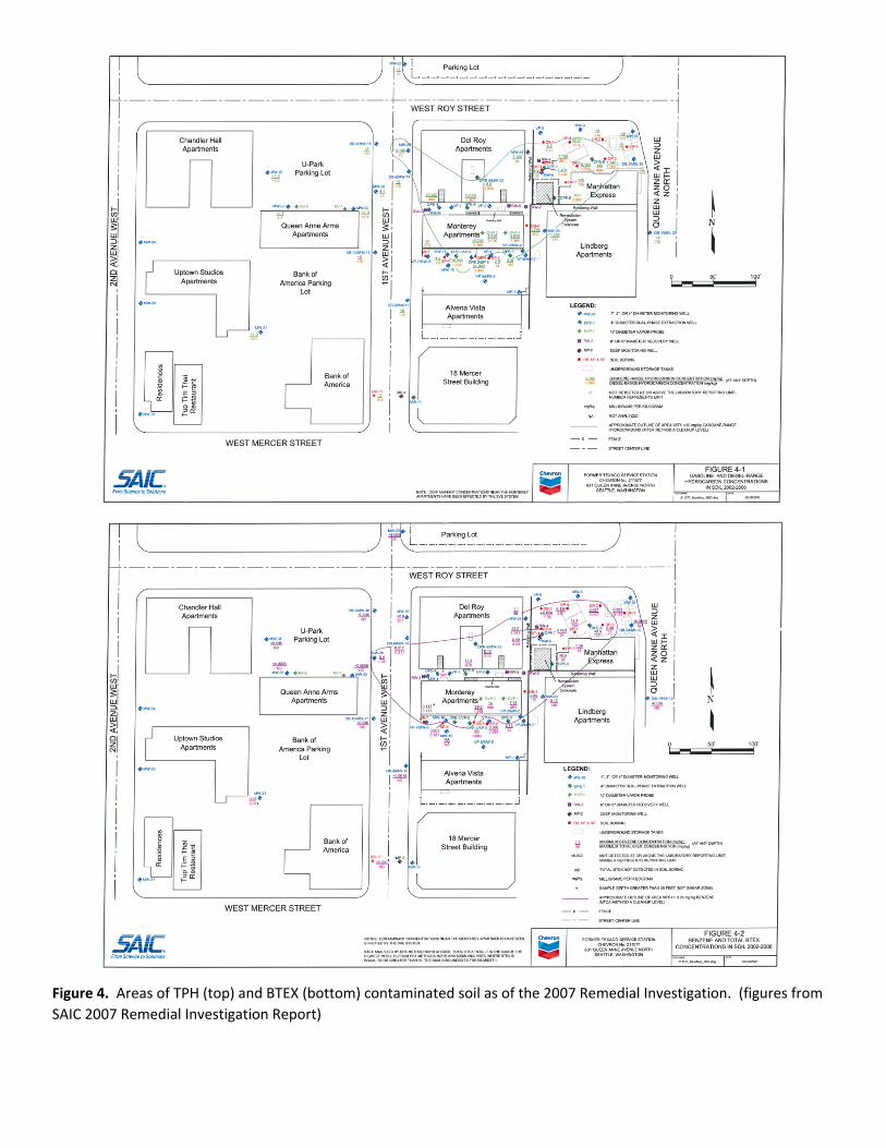
Figure 4. Areas of TPH (top) and BTEX (bottom) contaminated soil as of the 2007 Remedial Investigation. (figures from SAIC 2007 Remedial Investigation Report)

Figure 5. Areas of groundwater contamination as of the 2007 Remedial Investigation, as determined by including any well with a sample containing contaminants above cleanup levels prior to 2007. Moving from interior to exterior, the shapes surround wells with toluene, ethylbenzene, or xylene above cleanup levels (orange), TPH above cleanup levels (pink), and benzene above cleanup levels (green). Dark blue dots indicate wells where chlorinated solvents had been detected. (base figure from SAIC 2007 Remedial Investigation Report)

Figure 6. Concentrations and contours of soil gas concentration of volatile TPH from the extensive 1991 soil gas sampling event. (figure from E&E 1991 Phase 1 Remedial Investigation Report)

Figure 7. Location of contamination above Method A cleanup levels as of November 2013 groundwater monitoring. (base figure from SAIC 2007 Remedial Investigation Report)

Figure 8. Area of Texaco property with remaining petroleum contaminated soil including information from 2012 and 2017 on‐property investigations. (figure from Riley 2018 Cleanup Action Work Plan)

Figure 9. Results of recent groundwater sampling events on the Texaco property. (figure from Riley 2019 Groundwater Monitoring Report)

Figure 10. Estimated are of remaining contamination used for scoring. (figure from Riley 2018 Cleanup Action Work Plan)

Former Manhattan Express building, with Bungalows construction visible above the building. (all photos from 4/10/19 site visit)
West side of the former Manhattan Express building and area that formerly housed remediation system equipment. Building visible on the right is the Del Roy Apartments.

Western side of the Del Roy (left) and Monterey (right) Apartments, taken from across 1st Avenue W.
Eastern side of the Bungalows with construction visible above first floor retail. The main building of the Bayview residential community is visible in the background. (taken from across Queen Anne Ave N)

CSID: 6663Site: Texaco 211577 Monterey
Not scored.
Surface Water RouteWorksheet 4

CSID: 6663Site: Texaco 211577 Monterey
1.0 SUBSTANCE CHARACTERISTICS
1.1 IntroductionNo scoring in Section 1.1.
1.2 Human Toxicity
Substance
Value(ug/m3) Score
Value(mg/m3) Score
Value(mg/kg/day) Score
Adj. CPFi(risk/mg/kg‐
day) Score
naphthalene (TPH‐D) 2.94E‐02 10 ‐‐ X 8.57E‐04 10 5.95E‐02 5benzene (TPH‐G) 3.45E‐02 10 3.19E+04 3 8.57E‐03 8 2.73E‐02 5toluene 5.00E+03 1 ‐‐ X 1.43E+00 3 ‐‐ Xethylbenzene 4.00E‐01 10 ‐‐ X 2.86E‐01 3 ‐‐ Xxylenes ‐‐ X 2.17E+04 3 2.86E‐02 5 ‐‐ XMaximum score: 10Bonus points: 2 Human Toxicity Score: 12Source: WARM Toxicity Database Range: 1‐12
1.3 MobilityGaseous Mobility
SubstanceValue
(mm Hg) ScoreValue (atm‐m3/ mol) Score
naphthalene (TPH‐D) 8.20E‐02 3 4.83E‐04 3benzene (TPH‐G) 9.50E+01 4 5.56E‐03 4toluene 2.80E+01 4 6.63E‐03 4ethylbenzene 7.00E+00 3 7.88E‐03 4xylenes 1.00E+01 3 6.80E‐03 4Maximum score: 4Source: WARM Toxicity Database
Particulate MobilitySoil type:Erodibility factor:Climatic factor:Mobility value: Mobility Score: 4Source: Range: 0‐4
Worksheet 5Air Route
CarcinogenicityChronic ToxicityAcute ToxicityAmb. Air Stnd.
Henry's LawVapor Pressure

1.4 Human Toxicity/MobilitySource: WARM Scoring Manual Human Tox/Mobil Score: 24
Range: 1‐24
1.5 Environmental Toxicity/Mobility
Substance
Value(mg/m3) Score
naphthalene (TPH‐D) ‐‐ Xbenzene (TPH‐G) 3.19E+04 3toluene ‐‐ Xethylbenzene ‐‐ Xxylenes 2.17E+04 3Maximum score 3 Environmental Toxicity Score: 3Source: WARM Toxicity Database Range: 1‐10
Environmental Tox/Mobil Score: 6Range: 1‐24
1.6 Substance QuantityQuantity: 0.87 acresBasis:Source: site reports Substance Quantity Score: 6
Range: 1‐102.1 Containment
Description:Basis: site reports Containment Score: 5
Range: 0‐10
SUBSTANCE PARAMETER CALCULATIONS
Human Health PathwaySUBh (Human Tox/Mobil + 5) x (Containment +1) + Substance Quantity 180.0
Environmental PathwaySUBe (Environ. Tox/Mobil + 5) x (Containment +1) + Substance Quantity 72.0
3.0 TARGETS
3.1 Nearest PopulationDescription: commercial buildings to the north of source parcel across W Roy StDistance (ft): 70 Nearest Population Score: 10Source: iMap Range: 0‐10
vapor; contamination is >2' bgs, currently non functional vapor collection
Acute
site boundary from 2018 Riley cleanup action work plan

3.2 Nearest Sensitive EnvironmentDescription: Counterbalance ParkDistance (ft): 35 Nearest Sensitive Environment Score: 7Source: iMap Range: 0‐7
3.3 Population within One‐Half MileNumber: 11,933 Population within Half Mile Score: 75.0Source: MO CDC Range: 0‐75
TARGET PARAMETER CALCULATIONS
Human Health PathwayTARh=Nearest Population + Population within Half Mile 85.0
Environmental PathwayTARe Nearest Sensitive Environment 7.0
4.0 RELEASEEvid. of release? contaminants below screening levels in soil gas during most recent samplingSource: site reports Release Score (REL): 0.0
Range: 0 or 5
AIR ROUTE CALCULATIONS
Human Health PathwayAIRh =(SUBh x 60/329) x {REL + (TARh x 35/85} / 24 47.9
Environmental PathwayAIRe =(SUBe x 60/329) x {REL + (TARe x 35/85} / 24 1.6
Range: 0‐100

CSID: 6663Site: Texaco 211577 Monterey
1.0 SUBSTANCE CHARACTERISTICS
1.1 Human toxicity
SubstanceValue(ug/L) Score
Value(mg/kg) Score
Value(mg/kg/day) Score
Adj. CPFo(risk/mg/kg‐day) Score
naphthalene (TPH‐D) ‐‐ X 4.90E+02 5 2.00E‐02 1 ‐‐ Xbenzene (TPH‐G) 5.00E+00 8 3.31E+03 3 4.00E‐03 3 5.50E‐02 5toluene 1.00E+03 4 5.00E+03 3 8.00E‐02 1 ‐‐ Xethylbenzene 7.00E+02 4 3.50E+03 3 1.00E‐01 1 ‐‐ Xxylenes 1.00E+04 2 5.00E+01 10 2.00E‐01 1 ‐‐ XMaximum score: 10Bonus points: 2 Human Toxicity Score: 12Source: WARM Toxicity Database Range: 1‐12
1.2 Mobility
SubstanceValue(mg/L) Score
naphthalene (TPH‐D) 3.10E+01 1benzene (TPH‐G) 1.75E+03 3toluene 5.26E+02 2ethylbenzene 1.69E+02 2xylenes 1.71E+02 2Maximum value: 3 Mobility Score: 3Source: WARM Toxicity Database Range: 1‐3
1.3 Substance quantityQuantity: 12678 yd3
Basis:Source: site reports Substance Quantity Score: 5
Range: 1‐102.1 Containment
Description:Source: site reports Containment Score: 10
Range: 0‐10
Worksheet 6Groundwater Route
Solubility
site boundary from 2018 Riley cleanup action work plan (4226 yd2) x 3 yd thick
soil and groundwater are contaminated
Acute Toxicity Chronic ToxicityDrink. Wat. Stnd Carcinogenicity

SUBSTANCE PARAMETER CALCULATION
SUB = (Human Toxicity + Mobility + 3) x (Containment + 1 ) + Substance Quantity 203.0
2.0 MIGRATION POTENTIAL
2.2 Net precipitationAmount (in.): 23.3 Net Precipitation Score: 3Source: NOAA NCEI (Sand Point station data) and ESRI Range: 0‐5
2.3 Subsurface Hydraulic ConductivityDescription:Source: site reports Hydraulic Conductivity Score: 3
Range: 1‐4
2.4 Vertical Depth to AquiferDepth (ft): groundwater is contaminated Depth to Aquifer Score: 8Source: site reports Range: 1‐8
MIGRATION PARAMETER CALCULATION
MIG =Depth to Aquifer + Net Precipitation + Hydraulic Conductivity 14.0
3.0 TARGETS
3.1 Aquifer UsageDescription:
Source: iMap, WDOH Water System Database Aquifer Use Score: 2Range: 1‐10
3.2 Distance to Nearest Drinking Water WellDistance (ft): >2 mi Well Distance Score: 0Source: iMap, WDOH Water System Database Range: 0‐5
3.3 Population Served by Drinking Water Wells within Two Miles Population Served Score: 0.0No. of people: 0 Range: 0‐100Source: WDOH Water System Database, Well Log Viewer
3.4 Area Irrigated by Wells within Two Miles Area Irrigated Score: 0.0Area (acres): 0 Range: 0‐50Source: Water Resources Explorer
silty sand
Conservatively scored as not used but usable. Some site reports suggest non‐potability, but a full evaluation of potability was not observed during file review.

TARGET PARAMETER CALCULATION2.0
TAR = Aquifer Use + Well Distance + Population Served + Area Irrigated
4.0 RELEASEEvid. of release? detections in groundwater Release Score (REL): 5.0Source: site reports Range: 0 or 5
GROUND WATER ROUTE CALCULATION42.2
GW = (SUB x 40/208) x {(MIG x 25/17) + REL + (TAR x 30/165)} / 24Range: 0‐100

CSID: 6663Site: Texaco 211577 Monterey
Human Health Route Scores Human Health Pathway Quintiles ‐ based off August 2018 HSLPathway Score Quintile QuintileSurface water 0.0 1 <= 7.9 <= 8.6 <= 24.1Air 47.9 5 2 8.0 15.1 8.7 16.3 24.2 33.1Groundwater 42.2 4 3 15.2 21.2 16.4 25.3 33.2 40.4
4 21.3 29.7 25.4 40.1 40.5 49.6Quintile Value 5 >= 29.8 >= 40.2 >= 49.7High (H) 5Middle (M) 4Low (L)
(H2 + 2M + L) / 8 Human Health Priority Bin Score: 4.1
Environmental Route Scores Environmental Pathway Quintiles ‐ based off August 2018 HSLPathway Score Quintile QuintileSurface water 0.0 1 <= 11.3 <= 1.2Air 1.6 3 2 11.4 24.1 1.3 1.5
3 24.2 31.6 1.6 13.8Quintile Value 4 31.7 49.7 13.9 26.5High (H) 3 5 >= 49.8 >= 26.6Low (L)
(H2 + 2L) / 7 Environmental Priority Bin Score: 1.3
FINAL MATRIX RANKING
Human HealthPriority 5 4 3 2 1 n/a
5 1 1 1 1 1 14 1 2 2 2 3 23 1 2 3 4 4 32 2 3 4 4 5 31 2 3 4 5 5 5n/a 3 4 5 5 5 NFA
n/a ‐ not applicableNFA ‐ no further action Site Rank: 1
Washington Ranking Method
Environmental Priority
GroundwaterAirSurface Water
Surface Water Air
Route Scoring Summary and Ranking Calculation