site audit report overarching remedial action plan
TRANSCRIPT
Site Audit ReportOverarching Remedial Action
Plan, Barangaroo
Prepared for:
Barangaroo Delivery Authority
Prepared by: ENVIRON Australia Pty Ltd
Date: June 2010
Project Number: A121191
Audit Number: GN 439A

Level 3, 100 Pacific Highway, PO Box 560, North Sydney, NSW 2060 Tel: +61 2 9954 8100 Fax: +61 2 9954 8150 www.environcorp.com
ENVIRON Australia Pty Ltd ACN 095 437 442 ABN 49 095 437 442
2 June 2010 Our Ref: A121191
Barangaroo Delivery Authority Attn: Brian ten Brinke Level 3, Foreshore House 66 Harrington Street The Rocks NSW 2000
Dear Brian
Re: Site Audit Report – Overarching Remedial Action Plan, Barangaroo
I have pleasure in submitting the Site Audit Report for the subject site. The Site Audit Statement, produced in accordance with the NSW Contaminated Land Management Act 1997 follows this letter. The Audit was commissioned by Barangaroo Delivery Authority to assess the suitability of the overarching Remedial Acton Plan for the site known as Barangaroo.
The Audit was initiated to comply with a requirement by the Director General, application number MP10_0026 dated 23 March 2010.
Thank you for giving me the opportunity to conduct this Audit. Please call me on 9954 8100 if you have any questions.
Yours faithfully, ENVIRON Australia Pty Ltd
Graeme Nyland EPA Accredited Site Auditor 9808
/ DECCW
/ City of Sydney – statement only


Barangaroo Delivery Authority June 2010
Overarching Remedial Action Plan, Barangaroo
A121191 Z:\Projects\BDA\1191_Barangaroo RAP\SAR_1191_Barangaroo Whole Site RAP_2Jun10.doc
Contents 1 Introduction 1
2 Site Details 3 2.1 Location 3 2.2 Zoning 3 2.3 Adjacent Uses 3 2.4 Site Condition 4 2.5 Proposed Development 4
3 Site History 5
4 Contaminants Of Concern 6
5 Stratigraphy and Hydrogeology 7 5.1 Stratigraphy 7 5.2 Hydrogeology 8
6 Quality Assurance and Quality Control 9 6.1 Investigations 9 6.2 Proposed Remediation 12
7 Environmental Quality Criteria 13
8 Soil Analytical Results 14
9 Groundwater Analytical Results 16
10 Remediation Action Plan 17
11 Contamination Migration Potential 21
12 Compliance with Regulatory Guidelines And Directions 22
13 Conclusions and Recommendations 23
14 Other Relevant Information 24

Barangaroo Delivery Authority June 2010
Overarching Remedial Action Plan, Barangaroo
A121191 Z:\Projects\BDA\1191_Barangaroo RAP\SAR_1191_Barangaroo Whole Site RAP_2Jun10.doc
List of Tables
Table 3.1: Site History Table 4.1: Contaminants of Concern Table 5.1: Stratigraphy Table 6.1: QA/QC – Sampling and Analysis Methodology Assessment Table 6.2: QA/QC – Field and Lab Quality Assurance and Quality Control Table 8.1: Soil Analytical Results – Summary Table (mg/kg) Table 10.1: Remediation Requirements and Options Discussed Table 10.2: Evaluation of Remedial Action Plan
List of Appendices
Appendix A Attachments Appendix B Soil and Groundwater Criteria Appendix C EPA Guidelines

Barangaroo Delivery Authority June 2010
Overarching Remedial Action Plan, Barangaroo
A121191 Z:\Projects\BDA\1191_Barangaroo RAP\SAR_1191_Barangaroo Whole Site RAP_2Jun10.doc
List of Abbreviations AHD Australian Height Datum ALS Australian Laboratory Services ANZECC Australian and New Zealand Environment and Conservation Council BaP Benzo(a)pyrene BGL below ground level BTEX Benzene, Toluene, Ethylbenzene & Xylenes (Monocyclic Aromatic Hydrocarbons) CN Cyanide (total or free) CT Certificate of Title DP Deposited Plan DQO Data Quality Objectives EPA Environment Protection Authority (NSW) ESA Environmental Site Assessment report EQC Environmental Quality Criteria ha Hectare km Kilometres LOR Limit of Reporting m Metres MAH Monocyclic Aromatic Hydrocarbons Mercury Inorganic mercury unless noted otherwise Metals As: Arsenic, Cd: Cadmium, Cr: Chromium, Cu: Copper, Fe: Iron, Ni: Nickel, Pb: Lead, Zn:
Zinc, Hg: Mercury, Se: Selenium mg/kg Milligrams per Kilogram mg/L Milligrams per Litre m BGL Metres below ground level μg/L Micrograms per Litre NATA National Association of Testing Authorities NC Not Calculated ND Not Detected NEHF National Environmental Health Forum NEPM National Environment Protection Measure NHMRC National Health and Medical Research Council n Number of Samples OCP Organochlorine Pesticides OH&S Occupational Health & Safety OPP Organophosphorus Pesticides PAH Polycyclic Aromatic Hydrocarbons PCB Polychlorinated Biphenyls PID Photoionisation Detector PQL Practical Quantitation Limit pH a measure of acidity, hydrogen ion activity QA/QC Quality Assurance/Quality Control RAP Remediation Action Plan RPD Relative Percent Difference RWP Remediation Work Plan SEPP State Environmental Planning Policy SILs Soil Investigation Levels SVOCs Semi Volatile Organic Compounds TPHs Total Petroleum Hydrocarbons UCL Upper Confidence Limit VENM virgin excavated natural material VOCs Volatile Organic Compounds - On tables is "not calculated", "no criteria" or " not applicable"

Barangaroo Delivery Authority June 2010
Overarching Remedial Action Plan, Barangaroo
A121191 Z:\Projects\BDA\1191_Barangaroo RAP\SAR_1191_Barangaroo Whole Site RAP_2Jun10.doc

Barangaroo Delivery Authority June 2010
Overarching Remedial Action Plan, BarangarooPage 1
A121191 Z:\Projects\BDA\1191_Barangaroo RAP\SAR_1191_Barangaroo Whole Site RAP_2Jun10.doc
1 Introduction A site contamination audit has been conducted in relation to the site known as Barangaroo at Millers Point, NSW.
The Audit was conducted to provide an independent review by an EPA Accredited Auditor of the suitability and appropriateness of a remedial action plan i.e. a “Site Audit” as defined in Section 4 (1) (b) (v) of the NSW Contaminated Land Management Act 1997 (the CLM Act).
Details of the audit are:
Requested by: Brian ten Brinke on behalf of Barangaroo Delivery Authority (BDA)
Request/Commencement Date: 14 May 2010
Auditor: Graeme Nyland
Accreditation No.: 9808
The scope of the audit included:
• Review of the following report:
– Overarching Remedial Action Plan for The Barangaroo Project Site, Sydney”, dated 1 June 2010, Environmental Resources Management Australia Pty Ltd (ERM), Report 0114385RP01Final (the RAP)
• A site visit by the Auditor, 28 May 2010
• Discussions with BDA.
Barangaroo is a large site to be developed in stages and for a variety of uses. Separate remedial action plans are to be prepared for each development stage. Also, part of the site has been declared by NSW EPA to be a Remediation Site, which will also be the subject of a separate remedial action plan. As it is envisaged that remediation in different areas of the site will be linked, for example by re use of material from one part of the site in another, an overarching RAP has been prepared to identify strategies and remedial options for remediation of the whole site.
There have been a number of investigations over all or part of the site, which are summarised in the RAP. The reports which have been provided to the Auditor and briefly reviewed in preparation of this Site Audit Report are:
• ‘Report to Sydney Harbour Foreshore Authority on Geotechnical Investigation for Proposed Redevelopment of Wharves 3-8 at Hickson Road, Darling Harbour East, NSW’ dated 21 August 2006, by Jeffery and Katauskas Pty Ltd (J&K)
• ‘Land at Millers Point, Ownership and Usage’ dated 1 June 2007, by Rosemary Broomham
Barangaroo Delivery Authority June 2010
Overarching Remedial Action Plan, BarangarooPage 2
A121191 Z:\Projects\BDA\1191_Barangaroo RAP\SAR_1191_Barangaroo Whole Site RAP_2Jun10.doc
• ‘Environmental Site Assessment, East Darling Harbour, Sydney, NSW’ dated 21 June 2007, by Environmental Resources Management Australia Pty Ltd (ERM)
• ‘Preliminary Environmental Investigation at Hickson Road’ dated May 2008 by Coffey Environments Pty Ltd (Coffey)
• ‘Additional Investigation Works at Barangaroo, Hickson Road, Millers Point, NSW’ dated July 2008, by ERM.
More recently, further data gap investigations have been conducted by AECOM, and some draft reports have been provided to the Auditor.

Barangaroo Delivery Authority June 2010
Overarching Remedial Action Plan, BarangarooPage 3
A121191 Z:\Projects\BDA\1191_Barangaroo RAP\SAR_1191_Barangaroo Whole Site RAP_2Jun10.doc
2 Site Details 2.1 Location
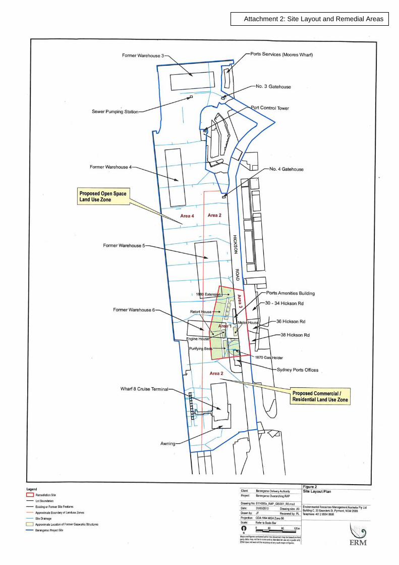
The site locality is shown on Attachment 1, Appendix A.
The site for the purpose of the RAP and the Audit is:
Street address: Barangaroo, Berths 3-8, Hickson Road
Identifier: Lots 1, 3, 4, 5 and 6 DP 876514, and part of Hickson Road adjacent to 30-38 Hickson Road
Local Government: City of Sydney
Owner: Barangaroo Delivery Authority (except Lot 4, which contains the Port Control Tower currently owned by Sydney Ports, and Hickson Road)
Site Area: approximately 22.6 ha.
The Barangaroo Project Site (see Attachment 2, Appendix A) includes several areas of roadway on Sussex Street, Hickson road and Towns Place not covered by the RAP.
2.2 Zoning
ERM advised the current zoning of the site is defined in Schedule 3 of the State Environmental Planning Policy (SEPP) (Major Development) 2005 as Zone B4 Mixed Use and Zone RE1 Public Recreation. Figure 3 of the RAP shows the Mixed Use zone along Hickson Road on the eastern side of the site and the Public Recreation zone on the western side adjoining Darling Harbour and at the northern end.
2.3 Adjacent Uses
The site is located in harbour-side location within an area of mixed residential and commercial use. Adjacent land uses are as follows:
North: Sydney Harbour
East: Commercial and some residential properties on eastern side of Hickson Road and beyond. A sandstone cut face marks part of the site boundary in the north east. The Port Control Tower adjoins the sandstone cut
South: King Street Wharf commercial/residential area
West: Darling Harbour

Barangaroo Delivery Authority June 2010
Overarching Remedial Action Plan, BarangarooPage 4
A121191 Z:\Projects\BDA\1191_Barangaroo RAP\SAR_1191_Barangaroo Whole Site RAP_2Jun10.doc
2.4 Site Condition
Based on information presented in the various reports and observations made during a site visit, the current site features are:
• The site is flat, at an elevation a few metres above Darling Harbour water level
• The site is covered by hard surfacing including concrete and bitumen with only a few structures and large light towers. Former large warehouses that were previously on the site have been demolished
• Wharf 8 Overseas Passenger Terminal, including a large warehouse style building and cruise ship loading dock is on the southern portion of the site. There are landscaped garden strips on the eastern and southern boundaries and the main driveway to Wharf 8 Terminal
• There is a disused brick amenities building and electrical substation in the southeast of the site near Hickson Road
• There are several security gate houses on the eastern side of the site
• There is a sewage pumping station in the north of the site
• Construction has commenced on a new temporary passenger terminal in the central northern part of the site.
2.5 Proposed Development
The site is to be redeveloped by BDA for future uses which include commercial, residential, open space and public thoroughfare. Details of specific developments are the subject of current and future development applications. It is likely that some developments will include excavations for basement car parking, and that excavated material may be able to be re-used as fill on other portions on the site, particularly those to be landscaped for use as public open space.
Parts of the proposed development fall within ‘residential with minimal access to soil’, ‘commercial/ industrial use’, and ‘recreational open space’ exposure scenarios. There will also be coves off Darling Harbour.

Barangaroo Delivery Authority June 2010
Overarching Remedial Action Plan, BarangarooPage 5
A121191 Z:\Projects\BDA\1191_Barangaroo RAP\SAR_1191_Barangaroo Whole Site RAP_2Jun10.doc
3 Site History ERM provided a site history based on aerial photographs, site photographs, title deed searches and previous environmental investigations. This is summarised in Table 3.1.
Table 3.1: Site History Date Activity
Pre 1939 The original shoreline ran approximately along the western edge of Hickson Road
1839-1921 Gasworks operated by The Australian Gas Light Company on part of the site and what is now Hickson Road. This part of the site is the declared Remediation Site. Remainder of site commercial and wharf use during this period.
1922-1925 Demolition of gas works infrastructure. Site used for workshops and storage warehouses.
1925-1936 Ship berthing and associated activities. Part of site became Hickson Road (1925).
1936-1951 Commercial leases.
1951-1972 Land reclaimed from harbour with fill from unknown source. Finger wharves demolished 1961-1968. New sea walls and new longshore wharfs constructed. Filling undertaken behind (east of) sea walls. Majority of Barangaroo filled with the exception of Southern Cove. Site used for various port related activities.
1972-2007 Commercial and port related activities continued. Southern Cove filled in late 1980s/ early 1990s. Overseas passenger terminal built 1999.
2007-present Majority of site vacated, warehouses demolished and site cleared. Wharf 8 Overseas Passenger Terminal still operating.
The summary indicates that the south eastern part of the site including the area now occupied by part of Hickson Road was used as a gasworks up until approximately 90 years ago. Structures included tar pits, gas holders and purifier beds. The remainder of the site has been used for wharf/ port related activities since the 1800s. In the Auditor’s opinion, the site history provides an adequate indication of past activities, with the primary potential for contamination from site use being from its use as a gasworks. The locations of the gasworks structures appear reasonably well known. Other site uses included workshops, vehicle maintenance and diesel fuel storage, which have potential for more localised contamination.
The major uncertainty in the site history appears to be the sequence and source of filling activity. Uncontrolled or undocumented fill was used in various stages of site reclamation. It does not appear that any sections of the site were filled during the gasworks operation, therefore, the use of gasworks waste in bulk filling seems unlikely, although potential remains for contaminated filling from other sources to have been used.

Barangaroo Delivery Authority June 2010
Overarching Remedial Action Plan, BarangarooPage 6
A121191 Z:\Projects\BDA\1191_Barangaroo RAP\SAR_1191_Barangaroo Whole Site RAP_2Jun10.doc
4 Contaminants Of Concern The RAP does not specifically discuss contaminants of concern, but discusses contaminants found in previous investigations. Based on the various investigations, the contaminants of concern and potentially contaminating activities are tabulated in Table 4.1.
Table 4.1: Contaminants of Concern Area Activity Potential Contaminants
Declared remediation Area
Former gasworks, waste products, gaskets
Could include metals, TPH, BTEX, PAHs, phenols, sulphate, cyanide, ammonia, asbestos
Whole of site Importation of fill materials to reclaim land
Unknown, could include metals, TPH, BTEX, PAHs, PCBs, OCPs, VOCs, SVOCs, asbestos
Whole of site Demolition of buildings Unknown, could include lead, PCBs, asbestos
Whole of site Land reclamation Acid sulphate soils (ASS)
The Auditor considers that the analyte list used in the investigations undertaken is generally appropriate for the site history and condition, though not all investigations included analysis for all contaminants of concern. There have been few asbestos analyses as ERM comment that asbestos would be difficult to detect with the investigation methods used. There has been limited analysis of some potential contaminants, and the metals analyte list consisted of the eight most common metal contaminants only. The RAP adequately identifies the contaminants to be considered in site development.

Barangaroo Delivery Authority June 2010
Overarching Remedial Action Plan, BarangarooPage 7
A121191 Z:\Projects\BDA\1191_Barangaroo RAP\SAR_1191_Barangaroo Whole Site RAP_2Jun10.doc
5 Stratigraphy and Hydrogeology Following a review of the reports provided, a summary of the site stratigraphy and hydrogeology was compiled as follows.
5.1 Stratigraphy
The RAP provides a summary of the site geology. The most comprehensive overall investigation of subsurface conditions is J&K 2006, which presents a series of borehole summary cross sections and contours of fill depth and bedrock elevation, based on 170 boreholes spread over the whole site.
The sub-surface profile of the site is summarised in Table 5.1.
Table 5.1: Stratigraphy Depth (m) Subsurface Profile
0 – 0.5 Hard surfacing, concrete or bitumen
Road base fill under hard surfacing
0 – 19 maximum Thickness increases east to west, 3m or less near Hickson Road
Fill, mainly sandy, possibly increasing in clay content with depth. Gravelly, silty or clayey in places. Contains sandstone floaters, as well as building rubble, brick and concrete
Overlying bedrock, thickest in central west part of the site at approximately 10m. Absent in northern area where sandstone was levelled
Alluvial sediments consisting predominantly of sandy clays
Varies, from shallow (north) to over maximum depth drilled 35m
Sandstone bedrock, shallower at the eastern portions and deepest over the western portion. Weathering and fracturing decreasing with depth
Based on review of the site history (refer Section 3) the site can be broken into the following stages of filling history:
• original filling of the eastern portion for development and construction of finger wharves, largely in the 1800s
• demolition of finger wharves and filling of the majority of the site (excluding Southern Cove) first in the southern portion (1961-1968) and then in the northern portion (approximately 1968-1972)
• filling of Southern Cove in late 1980s/ early 1990s.
None of the reports reviewed were able to identify different subunits within the fill.

Barangaroo Delivery Authority June 2010
Overarching Remedial Action Plan, BarangarooPage 8
A121191 Z:\Projects\BDA\1191_Barangaroo RAP\SAR_1191_Barangaroo Whole Site RAP_2Jun10.doc
In the Auditor’s opinion, the overall stratigraphic conditions are well known. Uncertainties include the distribution of different fill types and whether they will have any significance on contaminant distribution.
5.2 Hydrogeology
Groundwater at the site is shallow, generally within 2-3m BGL, and is subject to tidal fluctuations indicating a high degree of connectivity between groundwater at the site and the adjoining waters of Darling Harbour. The amplitude of tidal fluctuations decreases towards Hickson Road.
Wells subject to hydraulic conductivity testing were observed to recover almost instantaneously, reflecting the sand and gravel nature of fill material, although a wide range of hydraulic conductivity can be expected depending on the local fill type. As groundwater is shallow, service trenches may also provide more permeable flow paths.
Groundwater quality was saline, approaching seawater composition. The overall groundwater flow direction is to the west towards Darling Harbour, but the flow regime will be impacted by tidal influence and hydraulic conductivity variability in the fill. ERM also suggest that flow directions could be influenced by dewatering in basements on Hickson Road.
In the Auditor’s opinion, hydrogeological conditions are reasonably well know allowing for local variations, with overall flow towards Darling Harbour and migration of contaminants influenced by tidal action.
Barangaroo Delivery Authority June 2010
Overarching Remedial Action Plan, BarangarooPage 9
A121191 Z:\Projects\BDA\1191_Barangaroo RAP\SAR_1191_Barangaroo Whole Site RAP_2Jun10.doc
6 Quality Assurance and Quality Control 6.1 Investigations
The Auditor has briefly reviewed the overall quality of the investigation data by review of the information presented in the investigation reports. Sources for the data summarised in the RAP were:
• ERM (2007): investigations over the whole site at over 150 locations, 25 completed as monitoring wells. Some cored into bedrock, with rock core logs reported in J&K (2006)
• ERM (2008): additional 55 boreholes, 13 converted to monitoring wells. Thirteen cored into rock. Located over whole site but mainly in areas inaccessible during earlier investigation
• Coffey (2008): investigations on Hickson Road, including within the Remediation Site. Fifteen boreholes, some cored into rock, with five bores converted to monitoring wells.
This review was conducted to assess whether the data provides a sound basis for preparation of the Overarching RAP. It is anticipated that data sets relevant to each development area, including data obtained in proposed data gap investigations, will be reviewed in detail as part of audits of separate RAPs for each development area. Data requirements will vary depending on the actual remediation to be conducted in each area.
The Auditor’s assessment follows in Tables 6.1 and 6.2.
Table 6.1: QA/QC – Sampling and Analysis Methodology Assessment Sampling and Analysis Plan and Sampling Methodology
Auditor Comments
Sampling Pattern and Density Soil: The total number of investigation locations, 220, is comparable with the minimum recommended in Table A of EPA (1995) Sampling Design Guidelines. Investigations comprised relatively low density sampling to support a design competition and identify any further work needed to complete the development approval rather than full characterisation of the site. Of the ERM boreholes over the whole site, approximately 135 were on a grid pattern and the rest targeted, mainly towards the Remediation Area. Investigation locations were restricted by the presence of some buildings, as well as operational constraints of the various businesses on the site. The highest density investigations were in the Remediation Area and at the far north of the site. Lowest densities were: • In the southern end of the site, within the Wharf 8
building, where some locations are spaced over 60m apart
• In the central northern area, where locations are spaced up to 80m apart
• Along the western site boundary (shore), where few locations are spaced within 30m of the site boundary.

Barangaroo Delivery Authority June 2010
Overarching Remedial Action Plan, BarangarooPage 10
A121191 Z:\Projects\BDA\1191_Barangaroo RAP\SAR_1191_Barangaroo Whole Site RAP_2Jun10.doc
Table 6.1: QA/QC – Sampling and Analysis Methodology Assessment Sampling and Analysis Plan and Sampling Methodology
Auditor Comments
Groundwater monitoring wells were mainly installed • along the downgradient, western side of the site, typically
located 30-40m from the western site boundary. ERM attempted to place some wells as close as possible to the harbour.
• within and downgradient of the Remediation area. A few wells were also installed on the upgradient eastern boundary.
Sample depths Samples were collected from a range of depths within fill, but typically only 2-3 samples per bore were analysed. Samples were generally selected for analysis based on field indications (visual, olfactory, PID) and not related to fill type so it is not clear whether all fill layers and types were analysed. Some samples were obtained from alluvial soils. Sandstone bedrock was cored in a number of locations, but few samples were analysed.
Drilling method Most bores were advanced to about 1.5m using hand methods, then continued with solid stem auger. Due to difficult drilling conditions (obstructions, caving), some bores were continued with rotary mud methods. ERM (2008) advanced some bores to up to 12m using a 75mm geoprobe. Coring into rock was with a NMLC diamond core barrel.
Well construction All wells were constructed with 50mm PVC, 0.4mm slotted screens and bentonite seals. ERM (2007) wells typically screened the upper to middle sections of the fill. Screen lengths typically range from 3.5-7m. Coffey wells were screened across fill, with screen lengths from 0.7m to 9.5m long. ERM (2008) wells used a variety of screen lengths and mainly screened fill but some targeted either alluvial soil or bedrock. ERM wells were developed with submersible pumps and Coffey wells with bailers.
Sample Collection Method Soil: Samples were obtained from augers, SPT split spoon and geoprobe. Samples from augers were used for logging and field screening. Nearly all samples for laboratory analysis were semi undisturbed samples obtained from SPT, geoprobe or core. Groundwater: Purging was by low flow methods. ERM sampled using low flow methods and Coffey used bailers
Decontamination Downhole sampling equipment was decontaminated or dedicated, and new nitrile gloves were used in handling samples.
Field screening Field screening for volatiles was undertaken using a PID. PID

Barangaroo Delivery Authority June 2010
Overarching Remedial Action Plan, BarangarooPage 11
A121191 Z:\Projects\BDA\1191_Barangaroo RAP\SAR_1191_Barangaroo Whole Site RAP_2Jun10.doc
Table 6.1: QA/QC – Sampling and Analysis Methodology Assessment Sampling and Analysis Plan and Sampling Methodology
Auditor Comments
readings are recorded on borelogs. Calibration certificates were provided.
Sampling Logs Borehole logs are provided within the reports, indicating sample depth, PID readings and lithology. Soil logs generally provide adequate detail, though there were some constraints due to recovery. Coffey rock logs are detailed but ERMs provide limited detail of weathering and fracturing. All logs record indications of contamination such as odours and staining. Groundwater field sampling records were provided.
Table 6.2: QA/QC – Field and Lab Quality Assurance and Quality Control
Field and Lab QA/QC Auditor Comments
Field quality control samples Field quality control samples including trip blanks, trip spikes, rinsate blanks, field intra-laboratory and inter-laboratory duplicates were undertaken.
Field quality control results All reports include adequate data quality assessments. Minor QA/QC non conformances were reported.
NATA registered laboratory and NATA endorsed methods
Laboratories used were: ALS, Labmark and SGS. Laboratory certificates were NATA stamped.
Analytical methods Analytical methods were included in the laboratory test certificates.
Practical Quantitation Limits (PQLs)
PQLs were less than the threshold criteria for the contaminants of concern except for some groundwater analytes. Some PQLs were raised because of salinity or interference by other contaminants.
Laboratory quality control samples
Laboratory quality control samples including laboratory control samples, matrix spikes, surrogate spikes, blanks, internal standards and duplicates were undertaken.
Laboratory quality control results
No major quality control deficiencies were noted.
Although the Auditor has not undertaken a full QA/QC assessment of all data, the Auditor is able to conclude that:
• Investigation locations and sample depths are likely to be representative of the overall site conditions. Though conditions may vary locally, it is considered that the major issues affecting remediation would have been identified by the investigations conducted. As many samples were selected for analysis based on field indications of contamination, results are likely to be biased towards “worst case”

Barangaroo Delivery Authority June 2010
Overarching Remedial Action Plan, BarangarooPage 12
A121191 Z:\Projects\BDA\1191_Barangaroo RAP\SAR_1191_Barangaroo Whole Site RAP_2Jun10.doc
• The laboratories provided sufficient information to conclude that data is of sufficient precision, and field and laboratory quality control measures were sufficient to be confident that most of the data is likely to be accurate
• The data is generally complete and usable. The data set is large enough that minor departures from data quality objectives would not greatly impact the conclusions from the assessments
• Although different consultants, different staff and different laboratories were used, data appears to be sufficiently comparable for each sampling and analytical event.
The Auditor therefore concludes that the data is suitable as a basis for RAP preparation.
6.2 Proposed Remediation
The RAP includes a discussion of data quality objectives .It does not provide details of quality control measures to be applied during remediation. It requires:
• data to be used in risk assessments to be assessed for quality in accordance with NEPM (1999) Schedule B(3)- Guidelines on Laboratory Analysis of Potentially Contaminated Soils.
• Development of sampling, analysis and quality plans for validation programs, to be incorporated into specific Remediation Work Plans (RWPs).

Barangaroo Delivery Authority June 2010
Overarching Remedial Action Plan, BarangarooPage 13
A121191 Z:\Projects\BDA\1191_Barangaroo RAP\SAR_1191_Barangaroo Whole Site RAP_2Jun10.doc
7 Environmental Quality Criteria The RAP envisages that remediation and management will be based on quantitative human health and environmental risk assessment. Site Specific Target Criteria (SSTC) will be developed and incorporated into RWPs.
Default assessment criteria are listed in the RAP based on EPA-endorsed guidelines for different exposure scenarios which may be applicable to different areas of the site. Given the proximity to Darling Harbour, groundwater data has been assessed in reference to ANZECC (2000) Australian and New Zealand Guidelines for Fresh and Marine Water Quality for marine waters. Trigger values (TVs) provided are concentrations that, if exceeded, indicate a potential environmental problem and ‘trigger’ further investigation. The marine 95% level of protection has been selected as most appropriate. The above criteria are included in Appendix B.
The Auditor considers that risk based remediation criteria are appropriate, and should consider:
• protection of Darling Harbour from seepage of contaminants off the site after development, which must consider the impact of long term tidal flushing from residual contamination that remains on the site after development.
• suitability for the specific land uses based on possible exposure pathways.
The RAP does not provide a validation process for material to be re-used within the project site or imported to the site. A validation process will need to be included in the RAP or RWP for each area.

Barangaroo Delivery Authority June 2010
Overarching Remedial Action Plan, BarangarooPage 14
A121191 Z:\Projects\BDA\1191_Barangaroo RAP\SAR_1191_Barangaroo Whole Site RAP_2Jun10.doc
8 Soil Analytical Results The data set of soil analytical results includes over 500 primary samples, although not all samples were analysed for all the contaminants of concern listed in Section 4. The RAP presents maximum concentrations of contaminants detected in relation to four areas of the site, which are then discussed in the RAP in terms of remedial options for each area (see Section 10). All ERM (2007, 2008) data is used in the summary in Table 8.1 below.
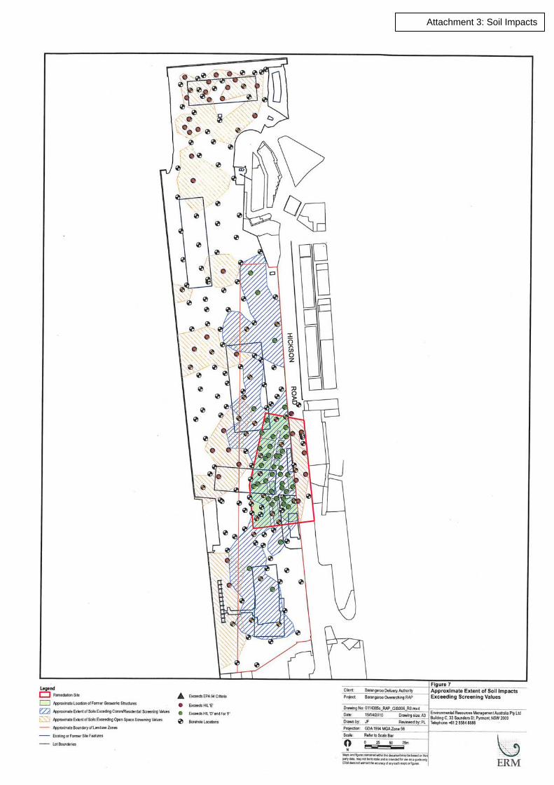
The results have been compared to the screening values (generally Soil Investigation Levels) which change for different areas of the site. The Auditor has not attempted to analyse data for each area as the areas considered by ERM will not correspond to development areas. Data sets for each development area will need to be considered in their respective RAPs/ RWPs. Also, additional data is being collected to address data gaps as applicable to each area prior to preparation of RAPs. Table 8.1 includes samples from fill, the majority of the samples, as well as a few samples from natural alluvial soil and bedrock. These will also need to be considered in individual RAPs. Table 8.1 provides an indication of the relative importance of each contaminant based on the number of exceedances of the screening values. Attachment 3 presents an indication of the distribution of the soil impacts exceeding screening values.
Table 8.1: Soil Analytical Results – Summary Table (mg/kg) Analyte n Detections Maximum n >
screening value
Asbestos 39 1 1
Arsenic 517 100 77 0
Cadmium 517 12 2 0
Total Chromium 517 510 141 0
Copper 517 378 1480 0
Lead 521 487 13800 11
Nickel 517 364 164 0
Zinc 517 458 4770 0
Mercury (inorganic) 516 211 8 0
Sulphate 272 259 31500 28
Total Cyanide 270 51 575 0
Speciated Phenols 192 1 1.1
PCBs 116 2 0.74
OCP /OPP 16 0 0
TPH (C6-C9) 439 38 1140 19
TPH (C10-C36) 439 107 147200 59

Barangaroo Delivery Authority June 2010
Overarching Remedial Action Plan, BarangarooPage 15
A121191 Z:\Projects\BDA\1191_Barangaroo RAP\SAR_1191_Barangaroo Whole Site RAP_2Jun10.doc
Table 8.1: Soil Analytical Results – Summary Table (mg/kg) Analyte n Detections Maximum n >
screening value
Benzene 410 34 140 25
Toluene 410 38 232 3
Ethyl benzene 410 29 63 1
Xylene 410 37 345 16
Total PAHs 376 234 20934 77
Benzo(a)Pyrene 376 187 652 88 n number of samples EQC Environmental Quality Criteria In considering the soil analytical data, the Auditor notes:
• The most detections of high concentrations of contaminants were recorded within the Remediation Area and at the northern end of the site near former Warehouse 3
• The most common contaminants are PAHs. These are mainly within the former gasworks (Remediation Area) as expected, and free phase tar was noted in and around the former gasworks structures. There were also detections, mainly at lower concentrations, over the remainder of the site
• While there is a high proportion of samples with elevated PAH concentrations near former Warehouse 3, the concentrations were generally much lower than at the former gasworks site
• Most of the high concentrations of TPH recorded were associated with PAHs
• Nearly all detections of volatiles (TPH C6-C9, BTEX) were within or close to and probably associated with the former gasworks area
• Lead is the main metal contaminant, but there were relatively few high concentrations of lead recorded. Most were with or near high PAH concentrations
• While there were a few elevated concentrations of other metals, mainly copper, mercury and zinc, there does not appear to be any indications of major metal contamination in soil (although some metals exceed groundwater trigger values)
• While most high concentrations recorded were from samples from the upper 5m, there were more samples analysed from the upper 5m, and sufficient high concentrations were detected lower in the fill to indicate that contamination is associated with the full depth of fill
• There were some indications of organic contamination in natural alluvial soils and bedrock, mainly in the gasworks area.
In the Auditor’s opinion, soil contamination at the site has been sufficiently characterised for the purpose of preparing a RAP.
Barangaroo Delivery Authority June 2010
Overarching Remedial Action Plan, BarangarooPage 16
A121191 Z:\Projects\BDA\1191_Barangaroo RAP\SAR_1191_Barangaroo Whole Site RAP_2Jun10.doc
9 Groundwater Analytical Results Groundwater samples were collected by ERM from 25 wells in 2008, including wells that had been installed and sampled in 2007. Groundwater was analysed for the contaminants of concern, though not all samples were analysed for all analytes. The RAP presents a table of the maximum concentration of each contaminant detected in groundwater.
In review of the results, the Auditor notes:
• Free tar, PAHs and TPH were recorded in many wells in the former gasworks area
• Much lower concentrations were recorded outside the former gasworks area including downgradient
• Dissolved metals especially zinc and copper were recorded in many wells across the site. While some may be associated with metals within fill (see Section 8), concentrations are relatively low.
The RAP (Section 10) envisages source removal but no active groundwater remediation. However this will need to be confirmed by the results of risk assessments to be completed.

Barangaroo Delivery Authority June 2010
Overarching Remedial Action Plan, BarangarooPage 17
A121191 Z:\Projects\BDA\1191_Barangaroo RAP\SAR_1191_Barangaroo Whole Site RAP_2Jun10.doc
10 Remediation Action Plan The RAP divides the site into four areas for the purpose of remediation. The areas are shown on Attachment 2. These areas do not correspond to development areas, but provide a logical approach to site remediation that can be adapted when future landuses are finalised. The Areas are:
• Area 1 – Portion of the Site within the Remediation Site zoned for commercial/ residential use
• Area 2 – Portion of the Site outside the Remediation Site zoned for commercial/ residential use
• Area 3 – Portion of the Site within the Remediation Site occupied by Hickson Road
• Area 4 – Portion of the Site outside the Remediation Site zoned for open space use.
The remediation goal is to both address the significant contamination on the Remediation Site and to render the site suitable for the proposed development. Table 10.1 lists the extent of remediation required and options presented for each area.
Table 10.1: Remediation Requirements and Options Discussed Description Extent of Remediation Required Options Discussed
Area 1 As a declared Remediation Site, all of Area 1 will require remediation. Remediation will need to extend into the bedrock where significant contamination is present
Do nothing – considered but eliminated Ex-situ on-site treatment – considered suitable for material to be excavated for development purposes, viability of different types of treatment plants to be established In-situ on-site treatment – considered possibly viable for material that does not require excavation for development purposes, requires proving Excavation, off-site treatment and reinstatement – considered less desirable than on-site treatment Off-site disposal – hazardous wastes would require pre-treatment, otherwise viable but less desirable than on-site treatment. May be required for some material that cannot be used on-site for earthworks balance or technical (tar) reasons On-site management – not desirable, would constrain development and require long term monitoring
Area 2 (Land to be developed outside of Remediation Site)
Known contamination impacts are not significant enough to warrant regulation by EPA. Suitability for proposed commercial/ residential use is still to be verified by risk assessment, and may require
Options include those for Area 1. Material excavated for basements could be reused in other parts of the project site. RAP states that in-situ treatment would not be practical but may be suitable for any contaminated material beneath basement level

Barangaroo Delivery Authority June 2010
Overarching Remedial Action Plan, BarangarooPage 18
A121191 Z:\Projects\BDA\1191_Barangaroo RAP\SAR_1191_Barangaroo Whole Site RAP_2Jun10.doc
Table 10.1: Remediation Requirements and Options Discussed Description Extent of Remediation Required Options Discussed
further validation
Area 3 (Hickson Road)
Within the declared Remediation Site, all of Area 3 will require remediation. Remediation will need to extend into the bedrock where significant contamination is present around former gasworks structures
Options include those for Area 1, but major excavation in Hickson Road is not desirable, therefore in-situ methods are preferred
Area 4 (Open space)
Known contamination impacts are not significant enough to warrant regulation by EPA. Suitability for proposed open space use is still to be verified by risk assessment, and may require further validation
Options include those for Area 1. In-situ treatment complicated by proximity to harbour. Excavation and reuse in Area 4 possible especially for shallow soil. Management more viable than other areas because of lesser amount of contamination and absence of basements.
Groundwater On-site treatment during dewatering of excavations, and possibly ongoing
Monitoring required to determine whether ongoing treatment or monitored natural attenuation (MNA) is required
The Auditor has assessed the RAP by comparison with the checklist included in EPA (1997) Guidelines for Consultants Reporting on Contaminated Sites, as detailed in Table 10.1 below.
Table 10.2: Evaluation of Remedial Action Plan Element Remedial Action Plan Auditor Comments
Remedial Objectives Initially address significant contamination on the Remediation Site, then make all of the site suitable for the proposed redevelopment
This goal is considered appropriate. Aim is to also remove sources of groundwater contamination. Proposed open space areas may also require remediation to prevent off-site migration of contamination in groundwater
Discussion of the extent of remediation required.
As discussed in Table 10.1 Groundwater remediation not envisaged in the RAP. This will need to be confirmed by risk assessment
Remedial Options As listed in Table 10.1 General options adequately identified
Selected Preferred Option Areas 1 and 3: does not provide preferred option because selection of strategy for the Remediation Site is subject to the VMP process after further assessment and trials. Area 2: excavation and ex-situ on-site treatment and reuse in other
Considered appropriate in principle, noting that risk assessment and probably further investigations are required to establish remediation extent, and further trials are required for treatment technologies
Barangaroo Delivery Authority June 2010
Overarching Remedial Action Plan, BarangarooPage 19
A121191 Z:\Projects\BDA\1191_Barangaroo RAP\SAR_1191_Barangaroo Whole Site RAP_2Jun10.doc
Table 10.2: Evaluation of Remedial Action Plan Element Remedial Action Plan Auditor Comments
areas of project site. May be supplemented by off-site disposal or other methods where excavation is not required for development purposes. Area 4: on-site management. May be supplemented by excavation in areas as determined by risk assessment
Rationale Options justified in terms of financial, environmental and social costs
Rationale considered reasonable
Proposed Validation Testing
Notes that validation methodologies need to be included in RWPs
Detailed validation plans required, including for material to be reused within the project site
Interim Site Management Plan (before remediation)
Not discussed Not required for contamination under current site condition
Site Management Plan (operation phase) including stormwater, soil, noise, dust, odour
Notes that preparation of development environmental management plans is required, and lists aspects that need to be included. Particularly notes potential for odours during excavation and possible requirement for excavation within negative pressure enclosure.
Level of detail considered appropriate for overarching RAP
Occupation health and safety
Notes that a Health and Safety Plan is required to be developed. RAP included information on contaminants to be considered
Level of detail considered appropriate for overarching RAP
Contingency Plan if Selected Remedial Strategy Fails
Outlines some unexpected conditions that could feasibly occur, and processes for managing them
Level of detail considered appropriate for overarching RAP
Contingency Plans to Respond to site Incidents. Site Management Plan for the Operation Phase.
Not discussed Should be in individual area RAPs/RWPs
Remediation Schedule Not provided, but notes that remediation of the gasworks structures beneath Hickson Road should be completed simultaneously with the development area
Voluntary Management Proposal for Remediation Site including Performance Schedule appended to RAP
Licence and Approvals Work is to be conducted in accordance with approvals obtained under Part 3A of the Environmental Planning and Assessment Act. The RAP notes that other licences
Needs to be included in individual area RAPs/RWPs

Barangaroo Delivery Authority June 2010
Overarching Remedial Action Plan, BarangarooPage 20
A121191 Z:\Projects\BDA\1191_Barangaroo RAP\SAR_1191_Barangaroo Whole Site RAP_2Jun10.doc
Table 10.2: Evaluation of Remedial Action Plan Element Remedial Action Plan Auditor Comments
and approvals may be required, such as an Environmental Protection Licence
Community Relations Notes need for Community Consultation Plan to notify all stakeholders
Staged Progress Reporting Envisages Site Audit Statements after validation of each area.
Long term environmental management plan
May be required to control risks from residual contamination and define ongoing monitoring requirements
May be appropriate if no ongoing risk and contingency in place for groundwater monitoring
The Auditor considers that the RAP provides an adequate basis for development of RAPs/ RWPs for individual areas of the site. It generally establishes the principle of on-site treatment and reuse when practical.

Barangaroo Delivery Authority June 2010
Overarching Remedial Action Plan, BarangarooPage 21
A121191 Z:\Projects\BDA\1191_Barangaroo RAP\SAR_1191_Barangaroo Whole Site RAP_2Jun10.doc
11 Contamination Migration Potential It is likely that contaminant migration into Darling Harbour has occurred. Given the time that has passed since the closure of the gasworks and of filling the site, and the significant decrease in contaminant concentrations measured in groundwater wells downgradient of the former gasworks, the extent of ongoing migration is uncertain. The risk from possible ongoing long term flushing of contaminants will need to be established by a risk assessment, and remediation standards established.

Barangaroo Delivery Authority June 2010
Overarching Remedial Action Plan, BarangarooPage 22
A121191 Z:\Projects\BDA\1191_Barangaroo RAP\SAR_1191_Barangaroo Whole Site RAP_2Jun10.doc
12 Compliance with Regulatory Guidelines And Directions Guidelines currently approved by the EPA under section 105 of the NSW Contaminated Land Management Act 1997 are listed in Appendix C. The Auditor has used these guidelines.
Director General’s Requirement No 3 for Application Number MP10-0026 covering remediation and land forming works, and Requirement No 5 for Application Numbers MP10-0022 and MP10-0023 require that a site wide Remediation Action Plan be prepared. The Overarching Remedial Action Plan that is the subject of this audit was prepared to fulfil that requirement. In the Auditor’s opinion:
• The investigations to date have been generally conducted in accordance with SEPP 55 Planning Guidelines
• The investigations have been generally reported in accordance with the EPA (1997) Guidelines for Consultants Reporting on Contaminated Sites.
Detailed Remediation Action Works Plan(s) are also required for relevant section(s) of the site, and will be prepared progressively. Those plans are required to be audited by an EPA accredited site auditor.

Barangaroo Delivery Authority June 2010
Overarching Remedial Action Plan, BarangarooPage 23
A121191 Z:\Projects\BDA\1191_Barangaroo RAP\SAR_1191_Barangaroo Whole Site RAP_2Jun10.doc
13 Conclusions and Recommendations This Site Audit Report has been prepared to determine the appropriateness of a plan of remediation.
The plan of remediation, entitled:
“Overarching Remedial Action Plan for The Barangaroo Project Site, Sydney”, dated 1 June 2010, Environmental Resources Management Australia Pty Ltd, Report 0114385RP01Final
was prepared to satisfy a Director General’s requirement for a site wide remediation action plan to be prepared for the Barangaroo project site.
The Auditor concludes that the Plan has fulfilled the requirement.
The Auditor notes that specific remediation action plans and more detailed remediation work plans will be prepared for each individual portion of the site. The principles incorporated into the overarching RAP which should be incorporated into each individual RAP include:
• Establishment of appropriate remediation end points applicable to both human health and the environment by a risk assessment that considers future landuse and potential long term impacts to Darling Harbour
• Establishment of a lateral and vertical extent of remediation that will address the remediation end points. This may require additional delineation investigations
• Development of technical details for the remediation methods proposed that support that the selected method(s) are technically feasible with a low chance of failure
• Sustainable remediation, by reuse of material within the Barangaroo project area where possible
• Documentation of a methodical and rigorous process for validation of the results of remediation.

Barangaroo Delivery Authority June 2010
Overarching Remedial Action Plan, BarangarooPage 24
A121191 Z:\Projects\BDA\1191_Barangaroo RAP\SAR_1191_Barangaroo Whole Site RAP_2Jun10.doc
14 Other Relevant Information This Audit was conducted on the behalf of Barangaroo Delivery Authority for the purpose of providing an independent review by an EPA Accredited Auditor of the suitability and appropriateness of a remedial action plan i.e. a “Site Audit” as defined in Section 4 (1) (b) (v) of the CLM Act.
This summary report may not be suitable for other uses. ERM and Coffey included limitations in their report. The audit must also be subject to those limitations. The Auditor has prepared this document in good faith, but is unable to provide certification outside of areas over which he had some control or is reasonably able to check.
The Auditor has relied on the documents referenced in Section 1 of the Site Audit Report in preparing his opinion. If the Auditor is unable to rely on any of those documents, the conclusions of the audit could change.
It is not possible in a Site Audit Report to present all data which could be of interest to all readers of this report. Readers are referred to the referenced reports for further data. Users of this document should satisfy themselves concerning its application to, and where necessary seek expert advice in respect to, their situation.

Barangaroo Delivery Authority June 2010
Overarching Remedial Action Plan, Barangaroo
A121191 Z:\Projects\BDA\1191_Barangaroo RAP\SAR_1191_Barangaroo Whole Site RAP_2Jun10.doc
Appendix A: Attachments
Attachment 1: Site LocationAttachment 2: Site Layout and Remedial Areas
Attachment 3: Soil Impacts

Attachment 1: Site Location
Attachment 2: Site Layout and Remedial Areas
Attachment 3: Soil Impacts

Barangaroo Delivery Authority June 2010
Overarching Remedial Action Plan, Barangaroo
A121191 Z:\Projects\BDA\1191_Barangaroo RAP\SAR_1191_Barangaroo Whole Site RAP_2Jun10.doc
Appendix B:Soil and Groundwater Criteria

Soil investigation levels for urban development sites Department of Environment and Conservation NSW (April 2006)
Health-based investigation levels1 (mg/kg) Provisional phytotoxicity-
based investigation
levels2 (mg/kg)
Residential with gardens and accessible soil (home-grown produce contributing < 10% fruit and vegetable intake; no poultry), including children’s day-care centres, preschools, primary schools, townhouses, villas (NEHF A)3
Residential with minimal access to soil including high-rise apartments and flats (NEHF D)
Parks, recreational open space, playing fields including secondary schools (NEHF E)
Commercial or industrial (NEHF F)
Substance
Column 1 Column 2 Column 3 Column 4 Column 5 Metals and metaloids
Arsenic (total) 100 400 200 500 20 Beryllium 20 80 40 100 – Cadmium 20 80 40 100 3 Chromium (III)4 12% 48% 24% 60% 400 Chromium (VI) 100 400 200 500 1 Cobalt 100 400 200 500 – Copper 1,000 4,000 2,000 5,000 100 Lead 300 1,200 600 1,500 600 Manganese 1,500 6,000 3,000 7,500 500 Methyl mercury 10 40 20 50 – Mercury (inorganic)
15 60 30 75 15
Nickel 600 2,400 600 3,000 60 Zinc 7,000 28,000 14,000 35,000 200
Organics Aldrin + dieldrin 10 40 20 50 – Chlordane 50 200 100 250 – DDT + DDD + DDE
200 800 400 1,000 –
Heptachlor 10 40 20 50 – PAHs (total) 20 80 40 100 – Benzo(a)pyrene
1 4 2 5 –
Phenol6 8,500 34,000 17,000 42,500 – PCBs (total) 10 40 20 50 –
Petroleum hydrocarbon components7 > C16–C35 (aromatics)
90 360 180 450 –
> C16–C35 5,600 22,400 11,200 28,000 – > C35 (aliphatics)
56,000 224,000 112,000 280,000 –
Other Boron 3,000 12,000 6,000 15,000 –8 Cyanides (complex)
500 2,000 1,000 2,500 –

Soil investigation levels for urban development sites Department of Environment and Conservation NSW (April 2006)
Health-based investigation levels1 (mg/kg) Provisional phytotoxicity-
based investigation
levels2 (mg/kg)
Residential with gardens and accessible soil (home-grown produce contributing < 10% fruit and vegetable intake; no poultry), including children’s day-care centres, preschools, primary schools, townhouses, villas (NEHF A)3
Residential with minimal access to soil including high-rise apartments and flats (NEHF D)
Parks, recreational open space, playing fields including secondary schools (NEHF E)
Commercial or industrial (NEHF F)
Substance
Column 1 Column 2 Column 3 Column 4 Column 5 Cyanides (free) 250 1,000 500 1,250 –
1 The limitations of health-based soil investigation levels are discussed in Schedule B(1) Guidelines on the Investigation Levels for Soil and Groundwater and Schedule B(7a) Guidelines on Health-based Investigation Levels, National Environment Protection (Assessment of Site Contamination) Measure 1999 (NEPC 1999)
2 The provisional phytotoxicity-based investigation levels proposed in this document are single number criteria. Their use has significant limitations because phytotoxicity depends on soil and species parameters in ways that are not fully understood. They are intended for use as a screening guide and may be assumed to apply to sandy loam soils or soils of a closely similar texture for pH 6–8.
3 National Environmental Health Forum (NEHF) is now known as enHealth. 4 Soil discolouration may occur at these concentrations. 5 Total mercury 6 Odours may occur at these concentrations. 7 The carbon number is an ‘equivalent carbon number’ based on a method that standardises according to boiling point.
It is a method used by some analytical laboratories to report carbon numbers for chemicals evaluated on a boiling point GC column.
8 Boron is phytotoxic at low concentrations. A provisional phytotoxicity-based investigation level is not yet available. Notes: This table is adapted from Table 5-A in Schedule B(1): Guidelines on Investigation Levels for Soil and Groundwater to the National Environment Protection (Assessment of Site Contamination) Measure 1999 (NEPC 1999). Soil investigation levels (SILs) may not be appropriate for the protection of ground water and surface water. They also do not apply to land being, or proposed to be, used for agricultural purposes. (Consult NSW Agriculture and NSW Health for the appropriate criteria for agricultural land.) SILs do not take into account all environmental concerns (for example, the potential effects on wildlife). Where relevant, these would require further consideration. Impacts of contaminants on building structures should also be considered. For assessment of hydrocarbon contamination for residential land use, refer to the Guidelines for Assessing Service Station Sites (EPA 1994).

Threshold Concentration for Sensitive Land Use – Soils Guidelines for Assessing Service Station Site (NSW EPA 1994)
Contaminant Threshold Concentration (mg/kg)
TPH (C6-C9) 65
TPH (C10-C36) 1,000
Benzene 1
Toluene 1.4
Ethylbenzene 3.1
Xylenes (total) 14

Trigger Values (TV) for Screening Marine Water Quality Data (µg/L) for Slightly to Moderately Disturbed Ecosystems (ANZECC 2000)
Contaminant Threshold Concentration
(µg/L))
Guideline Source
Metals and Metalloids Arsenic – As (III/V) 2.3/4.5 Low reliability trigger values (95% level of
protection) from Volume 2 of ANZECC (2000)
Cadmium – Cd 0.7 Mercury – Hg 0.1
ANZECC (2000) 99% protection level due to potential for bio-accumulation or acute toxicity to particular species.
Nickel – Ni 7 ANZECC (2000) 99% protection level due to potential for toxicity to particular species.
Manganese 80 Low reliability trigger values (derived from the mollusc figure) from Volume 2 of ANZECC (2000)
Chromium – Cr (III/VI) 27.4/4.4
Copper – Cu 1.3 Cobalt 1 Lead – Pb 4.4 Zinc – Zn 15
ANZECC (2000) 95% protection levels.
Aromatic Hydrocarbons Benzene 500 Toluene 180 Ethylbenzene 5 o-xylene 350 m-xylene 75 p-xylene 200
Low reliability trigger values (95% level of protection) from Volume 2 of ANZECC (2000)
Polycyclic Aromatic Hydrocarbons Naphthalene 50 ANZECC (2000) 99% protection level due
to potential for bio-accumulation or acute toxicity to particular species.
Anthracene 0.01 Phenanthrene 0.6 Fluroanthene 1
Benzo (a) pyrene 0.1
Low reliability trigger values from Volume 2 of ANZECC (2000) ANZECC (2000) 99% protection level due to potential for bio-accumulation or acute toxicity to particular species.
Chlorinated Alkanes Tetrachloroethene - PCE 70 1,1,2 Trichlorothene- TCE 330 1,1,2 Trichlorothene- 1,1,2-TCE 330 Vinyl chloride (chloroethene) 100 1,1,1 Trichloroethane – 1,1,1-TCA (111-TCE)
270
1,1 Dichloroethene 700 1,1 Dichloroethane 250 1,2 Dichloroethane 1900
Low reliability trigger values (95% level of protection) from Volume 2 of ANZECC (2000)
1,1,2 - Trichloroethane 1900 Moderate reliability trigger values (95% level of protection) from Volume 2 of ANZECC (2000)
Chloroform 370 Low reliability trigger values (95% level of protection) from Volume 2 of ANZECC (2000)
Non-Metallic Inorganics Ammonia Total – NH3 (at pH of 8)
910 ANZECC (2000) 95% protection levels.

Trigger Values (TV) for Screening Marine Water Quality Data (µg/L) for Slightly to Moderately Disturbed Ecosystems (ANZECC 2000)
Contaminant Threshold Concentration
(µg/L))
Guideline Source
Cyanide (Free or unionised HCN)
4
While the low reliability figures should not be used as default guidelines they will be useful for indicating the quality of groundwater migrating off-site.

Barangaroo Delivery Authority June 2010
Overarching Remedial Action Plan, Barangaroo
A121191 Z:\Projects\BDA\1191_Barangaroo RAP\SAR_1191_Barangaroo Whole Site RAP_2Jun10.doc
Appendix C:EPA Approved Guidelines


Guidelines made or approved by the EPA under section 105 of the Contaminated Land Management Act 1997
(as of 3 July 2009)
Guidelines made by the EPA
• Contaminated Sites: Guidelines for Assessing Service Station Sites, December 1994 - servicestnsites.pdf, 1.3Mb
• Contaminated Sites: Guidelines for the vertical mixing of soil on former broad-acre agricultural land, January 1995 - vertmix.pdf, 149kb
• Contaminated Sites: Sampling Design Guidelines, September 1995 • Contaminated Sites: Guidelines for Assessing Banana Plantation Sites, October
1997 - bananaplantsite.pdf, 586 kb • Guidelines for Consultants Reporting on Contaminated
Sites (97104consultantsglines.pdf; 209 KB), September 2000 • Contaminated Sites: Guidelines for Assessing Former Orchards and Market
Gardens, June 2005 - orchardgdlne05195.pdf, 172 kb • Contaminated Sites: Guidelines for the NSW Site Auditor Scheme (2nd edition),
April 2006 - auditorglines06121.pdf, 510kb • Guidelines for the Assessment and Management of Groundwater Contamination,
March 2007 - groundwaterguidelines07144.pdf 604 kb • Guidelines on the Duty to Report Contamination under the Contaminated Land
Management Act 1997, June 2009 - 09438gldutycontclma.pdf, 1 Mb
Note: All references in the EPA's contaminated sites guidelines to the Australian Water Quality Guidelines for Fresh and Marine Waters (ANZECC, November 1992) are replaced as of 6 September 2001 by references to the Australian and New Zealand Guidelines for Fresh and Marine Water Quality (ANZECC and ARMCANZ, October 2000), subject to the same terms.
Guidelines approved by the EPA
ANZECC publications
• Australian and New Zealand Guidelines for the Assessment and Management of Contaminated Sites, published by Australian and New Zealand Environment and Conservation Council (ANZECC) and the National Health and Medical Research Council (NHMRC), January 1992
• Australian and New Zealand Guidelines for Fresh and Marine Water Quality, Australian and New Zealand Environment and Conservation Council and Agriculture and Resource Management Council of Australia and New Zealand, Paper No 4, October 2000
EnHealth publications (formerly National Environmental Health Forum monographs)
• Composite Sampling, by Lock, W. H., National Environmental Health Forum Monographs, Soil Series No.3, 1996, SA Health Commission, Adelaide
• Environmental Health Risk Assessment: Guidelines for assessing human health risks from environmental hazards, Department of Health and Ageing and EnHealth Council, Commonwealth of Australia, June 2002

National Environment Protection Council publications
• National Environment Protection (Assessment of Site Contamination) Measure 1999
The Measure consists of a policy framework for the assessment of site contamination, Schedule A (Recommended General Process for the Assessment of Site Contamination) and Schedule B (Guidelines). Schedule B guidelines include: B(1) Guideline on Investigation Levels for Soil and Groundwater B(2) Guideline on Data Collection, Sample Design and Reporting B(3) Guideline on Laboratory Analysis of Potentially Contaminated Soils B(4) Guideline on Health Risk Assessment Methodology B(5) Guideline on Ecological Risk Assessment B(6) Guideline on Risk Based Assessment of Groundwater Contamination B(7a) Guideline on Health-Based Investigation Levels B(7b) Guideline on Exposure Scenarios and Exposure Settings B(8) Guideline on Community Consultation and Risk Communication B(9) Guideline on Protection of Health and the Environment During the Assessment of Site Contamination B(10) Guideline on Competencies & Acceptance of Environmental Auditors and Related Professionals
Other documents
• Guidelines for the Assessment and Clean Up of Cattle Tick Dip Sites for Residential Purposes, NSW Agriculture and CMPS&F Environmental, February 1996
• Australian Drinking Water Guidelines, NHMRC & Natural Resource Management Ministerial Council of Australia and New Zealand, 2004