site audit report - major projects
TRANSCRIPT

Site Audit Report

Suitability of Remediation Action Plan, Lot 9 in DP1205673, 28 McPherson Street, Banksmeadow i
J1130.39R‐rev0 ‐ 16‐May‐19 C. M. Jewell & Associates Pty Ltd
TABLE OF CONTENTS
1.0 INTRODUCTION ..................................................................................................................................... 1
1.1 Background ................................................................................................................................. 1
1.2 Scope and Structure of Review Report ...................................................................................... 4
1.3 Limitations and Intellectual Property Matters ........................................................................... 5
2.0 OVERVIEW OF WORKS COMPLETED AND INVOLVEMENT OF AUDITOR ............................................... 6
3.0 SITE INFORMATION ............................................................................................................................. 10
3.1 Site Identification and Location ................................................................................................ 10
3.2 Site Setting................................................................................................................................ 10
3.3 Site Layout, Topography and Drainage .................................................................................... 10
3.3.1 Site Layout ................................................................................................................ 10
3.3.2 Topography .............................................................................................................. 11
3.3.3 Drainage ................................................................................................................... 11
3.4 Geology ..................................................................................................................................... 11
3.5 Hydrogeology ........................................................................................................................... 11
3.6 Site History ............................................................................................................................... 11
3.7 Summary of Identified Contamination Issues .......................................................................... 13
3.7.1 Groundwater ............................................................................................................ 13
3.7.2 Asbestos ................................................................................................................... 14
3.7.3 Ground Gases ........................................................................................................... 14
3.8 Proposed Development ............................................................................................................ 14
3.9 Assessment Criteria .................................................................................................................. 15
3.9.1 Soil ............................................................................................................................ 15
3.9.2 Soil Vapour/Ground Gas ........................................................................................... 16
3.9.3 Groundwater ............................................................................................................ 17
4.0 SUMMARY OF RELEVANT INVESTIGATION WORK .............................................................................. 18
4.1 Stage 1 Preliminary Investigation (AGEE 1990) ........................................................................ 18
4.2 Stage 2 Survey (WWC 1996) ..................................................................................................... 18
4.3 Stage 4 Investigations ............................................................................................................... 19
4.3.1 Full Scale Reactive Iron Barrier, Data Gaps Report (URS 2004a).............................. 19
4.3.2 2004 DNAPL Source Area Investigation (URS 2004b) ............................................... 19
4.4 Preliminary Soil Investigations (HLA 2005) ............................................................................... 19
4.5 Southern Plumes Source Area Delineation Investigation (URS 2006) ...................................... 20
4.6 Shallow Contaminated Soil/Fill Delineation and Waste Management (Golder 2012b) ........... 21
4.7 Review of Risk Issues – Groundwater Discharge to Springvale Drain (EnRiskS 2012) .............. 22
4.8 Delineation of Remediation Areas (JBS&G 2014b) ................................................................... 23
4.9 Asbestos and Vapour Assessment (JBS&G 2018b) ................................................................... 24
4.10 Auditor’s Review of Investigations ........................................................................................... 25
5.0 SUMMARY OF PREVIOUS REMEDIATION WORK ................................................................................. 26
5.1 Soil Hotspot Validation (JBS&G 2015d) .................................................................................... 26
5.1.1 Removal of Vegetation ............................................................................................. 26
5.1.2 Stripping of Superficial Soils ..................................................................................... 26
5.1.3 Monitoring and Extraction Well Decommissioning.................................................. 26
5.1.4 Air and Environmental Monitoring .......................................................................... 26
5.1.5 Excavation of Hotspots and Stockpiles ..................................................................... 27
5.1.6 Stockpiled Materials from the Compensatory Flood Basin ...................................... 27
5.1.7 Waste Materials Disposed Off‐Site or Placed on Block 2 ......................................... 27
5.1.8 Soil from Block 2 ....................................................................................................... 27
5.1.9 Validation Results ..................................................................................................... 27

ii Suitability of Remediation Action Plan, Lot 9 in DP1205673, 28 McPherson Street, Banksmeadow
C. M. Jewell & Associates Pty Ltd J1130.39R‐rev0 ‐ 16‐May‐19
6.0 CONCEPTUAL SITE MODEL AND CONTAMINATION ASSESSMENT ..................................................... 29
6.1 Topographic Setting ................................................................................................................. 29
6.2 Geology .................................................................................................................................... 29
6.2.1 Regional.................................................................................................................... 29
6.2.2 Local ......................................................................................................................... 30
6.3 Hydrogeology ........................................................................................................................... 31
6.3.1 Groundwater Flow Regime ...................................................................................... 31
6.3.2 Groundwater Levels ................................................................................................. 32
6.3.3 Hydraulic Characteristics .......................................................................................... 32
6.4 Groundwater and Surface Water Interaction near the Springvale Drain ................................ 33
6.5 Site Contamination Issues ........................................................................................................ 33
6.6 Contaminants of Potential Concern ......................................................................................... 34
6.7 Updated CSM (Orica 2017) ...................................................................................................... 34
7.0 HUMAN HEALTH RISK ASSESSMENT ................................................................................................... 36
7.1 Methodology ............................................................................................................................ 36
7.2 Risk Issues on Block 1 ............................................................................................................... 37
7.2.1 Review of Groundwater Data .................................................................................. 37
7.2.2 Review of Soil Gas and Flux Emissions Data ............................................................ 38
7.2.3 Exposure Pathways ‐ Specifically Related to Lot 9 ................................................... 38
7.3 Assessment of Risk – Asbestos ................................................................................................. 39
7.3.1 Assessment of Risk ‐ Asbestos ‐ Specifically Related to Lot 9 .................................. 40
7.4 Assessment of Risk – Vapour Intrusion .................................................................................... 40
7.4.1 Vapour Intrusion from Groundwater ....................................................................... 40
7.4.2 Vapour Intrusion from Springvale Drain .................................................................. 43
7.4.3 Assessment of Risk – Ground Gas ............................................................................ 44
7.5 EnRiskS Conclusions ................................................................................................................. 46
7.6 Auditor’s Review of EnRiskS (2019) ......................................................................................... 46
7.7 Auditor’s Review of Potential Impacts on Neighbouring Properties ....................................... 48
8.0 REMEDIATION ACTION PLAN .............................................................................................................. 49
8.1 Remediation/Management Approach ..................................................................................... 49
8.2 Geotechnical and Foundation Issues associated with Deck Construction ............................... 49
8.3 Regulatory Compliance ............................................................................................................ 50
8.4 Barrier System (Management of Asbestos in Soil) ................................................................... 50
8.5 Vapour/Gas Mitigation System ................................................................................................ 51
8.6 Waste Classification and Off‐Site Disposal of Soils .................................................................. 51
8.7 Backfilling of Excavations and Physical Separation Layer ........................................................ 52
8.8 Validation ................................................................................................................................. 52
8.9 Unexpected Finds ..................................................................................................................... 52
8.10 Ongoing Monitoring/Management .......................................................................................... 52
8.11 Auditor’s Review ...................................................................................................................... 53
9.0 AUDITOR’S ASSESSMENT OF THE SUITABILITY OF THE REMEDIATION ACTION PLAN ....................... 54
9.1 Risks to Human Health ............................................................................................................. 54
9.2 Risk to Structures ..................................................................................................................... 55
9.3 Risk to the Environment ........................................................................................................... 55
9.4 Regulatory Compliance ............................................................................................................ 55
9.5 Potential Contaminant Migration ............................................................................................ 55
9.6 Groundwater Issues ................................................................................................................. 55
9.7 Aesthetic Issues ........................................................................................................................ 56
9.8 Chemical Mixtures.................................................................................................................... 56
9.9 Short‐Term and Long‐Term Management ............................................................................... 56
9.10 EPA Guideline Requirements ................................................................................................... 56
Suitability of Remediation Action Plan, Lot 9 in DP1205673, 28 McPherson Street, Banksmeadow iii
J1130.39R‐rev0 ‐ 16‐May‐19 C. M. Jewell & Associates Pty Ltd
10.0 AUDITOR’S CONCLUSIONS AND RECOMMENDATIONS ...................................................................... 58
10.1 Overview .................................................................................................................................. 58
10.2 Adequacy of Investigation ........................................................................................................ 58
10.3 Adequacy of Risk Assessment .................................................................................................. 58
10.4 Suitability of Remediation Action Plan ..................................................................................... 58
REFERENCES ................................................................................................................................................... 59
Important Information About Your Site Audit
TABLES
Table 1 Chronological Summary of Significant Events Table 2 Review of Historical Aerial Photography Table 3 Groundwater Contaminants Table 4 Soil Assessment Criteria Table 5 Summary of Remediation Work at Hotspots and Stockpiles – Lot 9 Table 6 Site Stratigraphy Table 7 Hydraulic Characteristics Table 8 Summary and Review of Soil Vapour Data ‐ Lot 9 Table 9 Guidance Values for Gas Protection Table 10 Scores for Protection Measures
FIGURES
Figure 1 Site Location Figure 2 Site Setting Figure 3 Proposed Development Figure 4 Location of Testpits (JBS&G 2018) Figure 5 Schematic Cross‐Section of the Groundwater Flow System Figure 6 Contours on the Buried Surface of the Hawkesbury Sandstone Figure 7 Location and Nomenclature of Groundwater Contaminant Plumes Figure 8 Barrier Layer Areas
APPENDICES
Appendix A Contaminant Groups Appendix B Copies of the Associated Reports that the Auditor has Specifically Relied Upon
(provided on CD) Appendix C Copies of Relevant Letter Reports, Supporting Documentation and Communications Appendix D Auditor Checklists
D1 Auditor’s Assessment of the Consultant’s Use of Data Quality Objectives and Data Quality Indicators, and Review of Quality Assurance/Quality Control Data
D2 Auditor’s Review of the Human Health Risk Assessment
ASSOCIATED REPORTS
Remediation Action Plan, 28 McPherson Street, Banksmeadow NSW, prepared by JBS&G Australia Pty Ltd (ref. 54709/119224 Rev0), dated 15 May 2019
Southlands Block 1 HHRA Revision: Development of Flood Detention Basn, prepared by Environmental Risk Sciences Pty Ltd, dated 24 January 2019
Assessment of Potential for Accumulation of Ground Gases Associated with Proposed Warehouse Distribution and Office Development, Lot 9, 28 McPherson Street, Banksmeadow NSW, prepared by JBS&G Australia Pty Ltd (ref. 54709‐119907 rev2), dated 7 February 2019
Asbestos and Vapour Assessment, Lot 9 in DP1205673, 28 McPherson Street, Banksmeadow, prepared by JBS&G Australia Pty Ltd (ref. 54709/114803 Rev A), dated 14 August 2018

iv Suitability of Remediation Action Plan, Lot 9 in DP1205673, 28 McPherson Street, Banksmeadow
C. M. Jewell & Associates Pty Ltd J1130.39R‐rev0 ‐ 16‐May‐19
Conceptual Site Model, Orica Botany, prepared by Orica Australia Pty Ltd, dated 20 September 2017
Human Health Risk Assessment, Southlands Block 1 Development, prepared by Environmental Risk Sciences (ref. O/15/SDB1R001‐revB), dated 31 July 2015
Soil Hotspot Validation Report, Block 1, Southlands, 28 McPherson Street, Banksmeadow NSW, prepared by JBS&G Australia Pty Ltd (ref. 43499/100797 Rev0), dated 31 July 2015
Delineation of Remediation Areas, Southlands, McPherson Street, Banksmeadow, NSW, prepared by JBS&G Australia Pty Ltd (ref. 43499‐57915), dated 24 July 2014
Review of Groundwater‐Surface Water Interaction at Springvale Drain, Southlands Development Site, Banksmeadow, NSW, prepared by JBS Environmental Pty Ltd (ref. JBS 42049‐54480), dated 23 May 2013
Review of Risk Issues – Groundwater Discharge to Springvale Drain, prepared by Environmental Risk Sciences, dated 1 June 2012
Shallow Contaminated Soil/Fill Delineation and Waste Management Report, Orica Southlands, prepared by Golder Associates Pty Ltd (ref. 117623028‐002‐Rev1), dated 16 March 2012
Conceptual Site Model – Botany, prepared by URS Australia Pty Ltd (ref. 43217627, revision 0), dated 23 November 2007
Southern Plumes Source Area Delineation Investigation ‐ February 2006, prepared by URS Australia Pty Ltd (ref. 43346038.07901), dated 19 June 2006
Factual Report on Preliminary Soil Investigation, Orica Botany – Southlands, NSW, prepared by HLA‐Envirosciences Pty Limited (ref. S4039401_RPT_25Aug05), dated 25 August 2005
Orica Botany Environmental Survey Stage 4 – Remediation, 2004 DNAPL Source Area Investigation, prepared by URS Australia Pty Ltd, dated August 2004
Orica Botany Environmental Survey Stage 4 – Remediation, Full Scale Reactive Iron Barrier ‐ Data Gaps ‐ Module 2a, prepared by URS Australia Pty Ltd (ref. 46160‐005/R010_A), dated 12 May 2004
Block 2 Southlands DNAPL Investigation, prepared by AGC Woodward‐Clyde Pty Limited (ref. R004‐A), dated August 1996
State Pollution Control Commission, ICI Botany Environmental Survey, Stage 1 Preliminary Investigations, prepared by A G Environmental Engineers in association with Woodward‐Clyde Consultants (USA), dated May 1990

List of Abbreviations
Page 1 QaO.31 List of Abbreviations
CMJA
General
ACM asbestos‐containing material AF asbestos fines AFP Australian Federal Police AGEE Australian Groundwater Environmental Engineers AHD Australian Height Datum ASC NEPM National Environment Protection (Assessment of Site Contamination) Measure 1999 B(a)P benzo(a)pyrene BGCP Botany Groundwater Cleanup Program BIP Botany Industrial Park BTEX benzene, toluene, ethylbenzene, xylene CEMP construction environmental management plan CFM chloroform CHC chlorinated hydrocarbon CLM Act Contaminated Land Management Act 1997 CMJA C. M. Jewell & Associates Pty Ltd COPC contaminant of potential concern CPT cone penetrometer test CPWE carpark waste encapsulation CQA construction quality assurance CS characteristic gas situation CSM conceptual site model CTC carbon tetrachloride DBL DBL Property Pty Limited DCE dichloroethene DNAPL dense non‐aqueous‐phase liquid DP deposited plan DPE Department of Planning and Environment EA Environmental Assessment EDC 1,2‐dichloroethane ENM excavated natural material EnRiskS Environmental Risk Sciences Pty Ltd EPA Environment Protection Authority EP&A Act Environmental Planning and Assessment Act 1979 ETP effluent treatment plant FA fibrous asbestos FSRIB full‐scale reactive iron barrier GCP groundwater cleanup plan Golder Golder Associates Pty Ltd GTP groundwater treatment plant HCB hexachlorobenzene HCBD hexachlorobutadiene HCE hexachloroethane HHRA human health risk assessment HI hazard index HIL health investigation level HLA HLA‐Envirosciences Pty Ltd HSL health screening level ICI ICI Australia Limited IL investigation level JBS&G JBS&G Australia Pty Ltd LTSEMP long‐term site environmental management plan LOR limit of reporting NCUA Notice of Clean‐up Action

List of Abbreviations
Page 2 QaO.31 List of Abbreviations
CMJA
Orica Orica Australia Pty Ltd PAH polycyclic aromatic hydrocarbons PCA primary containment area PCE tetrachloroethene PCL primary containment line PID photoionisation detector PRG Preliminary Remediation Goal PSRIB pilot scale reactive iron barrier RAP remediation action plan RSL Regional Screening Level SAQP sampling analysis and quality plan SAR site audit report SAS site audit statement SCA secondary containment area SEARs Secretary’s Environmental Assessment Requirements SLR SLR Consulting Australia Pty Ltd SRA State Rail Authority SSD State Significant Development TASR temporary aquifer storage and recovery TCA trichloroethane TCE trichloroethene TeCA tetrachloroethane TEQ toxic equivalents TPH total polycyclic hydrocarbons TRH total recoverable hydrocarbon URS URS Australia Limited USEPA United States Environment Protection Agency UST underground storage tank VC vinyl chloride VENM virgin excavated natural material VMP voluntary management proposal VOC volatile organic compound VRA voluntary remediation agreement WHO World Health Organization WWC AGC Woodward‐Clyde Pty Limited Measurements
% per cent µg/m3 micrograms per cubic metre cm centimetre f/ml fibres per millilitre km2 square kilometre m metre m/d metres per day m/s metres per second ML/d megalitres per day mg/kg milligrams per kilogram mg/L milligrams per litre mm millimetre MPa mega pascals ppm parts per million v/v volume per volume w/w weight per weight

Suitability of Remediation Action Plan, Lot 9 in DP1205673, 28 McPherson Street, Banksmeadow 1
J1130.39R‐rev0 ‐ 16‐May‐19 C. M. Jewell & Associates Pty Ltd
1.0 INTRODUCTION
1.1 Background
This Site Audit Report (SAR) relates part of the property located at 28 McPherson Street, Banksmeadow, in New South Wales (the site). The location of the site is shown on Figure 1. At the date of this SAR, the description of the site is Lot 9 in DP1205673, and the owner is Orica Limited. This SAR summarises a process of assessment of contamination affecting the site, and the procedures and standards to be followed in order to manage the risks posed by contaminated soil and groundwater and associated vapour/gas, to make the site suitable for the proposed commercial/industrial land use. Historically, the site that is now Lot 9 was part of the property known as ‘Southlands’ which was located at 26‐28 McPherson Street, Banksmeadow. Southlands was comprised of two blocks of land, referred to as Block 1 and Block 2. The site that this SAR describes was originally part of Block 1 Southlands and sections of this SAR refer to that nomenclature. A history of the investigation and remediation work carried out at Southlands is provided below. Southlands has been the subject of a number of notices, orders and agreements issued by the NSW Environment Protection Authority (EPA) and its numerous predecessor organisations, back to the State Pollution Control Commission. Current EPA notices relevant to the site are:
Declaration of Remediation Site (Section 21 of the Contaminated Land Management Act 1997 – CLM Act), Declaration No. 21074, Area No. 3203, dated 9 February 2005 (amended 26 June 2017);
Notice of Approval of Voluntary Management Proposal (Section 17 of the CLM Act), Notice No. 20151711, Area No. 3203, dated 13 August 2015;
Notice to Amend Approved Voluntary Management Proposal No. 20151711 (Section 44 of the CLM Act), Notice No. 20164428, Area No. 3203, dated 15 December 2016; and
Notice to Amend Approved Voluntary Management Proposal No. 20151711 (Section 44 of the CLM Act), Notice No. 20174415, Area No. 3203, dated 19 June 2017.
In July 2006, Orica Australia Limited (Orica) submitted a development application (06‐0191) under Part 3A (as then in force) of the Environmental Planning and Assessment Act 1979 (EP&A Act) to the NSW Department of Planning for the Southlands Remediation and Development Project (the Project). The Project was divided into three stages, Stage 1 of the proposed Project related to the development of Block 2, whilst Stages 2 and 3 were relevant to the development of Block 1. In 2008, as part of the Environmental Assessment (EA) for the Project, URS Australia Pty Ltd (URS) prepared a Remediation Action Plan (RAP) (URS 2008e) for the entire Southlands property (i.e. Blocks 1 and 2). The remediation strategy included remediation of a number of identified soil ‘hotspots’, installation of a layer of clean fill material to manage asbestos‐impacted soil and mitigation measures for potential vapour emissions. Hotspots requiring remediation were identified by comparison of soil contaminant concentrations against site specific risk‐based soil criteria derived in a Human Health Risk Assessment (HHRA) (URS 2008d) undertaken for the property. On 25 November 2008, a Draft Site Audit Statement (SAS) (SA263) and supporting Draft SAR (J1130.10R‐rev0) (CMJA 2008) were issued by the Auditor, Christopher Jewell. The SAS indicated that the RAP (URS 2008e) was suitable and appropriate, and that if followed, the property could be made suitable for commercial use. Project Approval under Section 75J of the EP&A Act for the development of Southlands was granted by NSW Minister for Planning on 16 December 2012 (Project Approval 06_0191) (since modified by the Minister for Planning and Infrastructure on 14 August 2013, 22 April 2015, 17 February 2016 and 10 June 2016).

2 Suitability of Remediation Action Plan, Lot 9 in DP1205673, 28 McPherson Street, Banksmeadow
C. M. Jewell & Associates Pty Ltd J1130.39R‐rev0 ‐ 16‐May‐19
In January 2014, due to proposed substantial changes from the development approved in the original Project Approval, the availability of additional information in relation to the characterisation of risk at the property (EnRiskS 2013) and the release, in May 2013, of the amended National Environment Protection (Assessment of Site Contamination) Measure 1999 (ASC NEPM), JBS&G Australia Pty Ltd (JBS&G) prepared a Revised RAP for Stage 1 (Block 2) of the Project (JBS&G 2014a). Although focussing on Block 2, JBS&G’s Revised RAP also identified areas of soil on Block 1 requiring remediation, not including asbestos‐impacted soil, so that they could be remediated concurrently with the Block 2 remediation works. On 30 January 2014, a Statutory Section B SAS (SA263/1) and supporting SAR (J1130.17R‐rev0) (CMJA 2014) were issued by the Auditor, Christopher Jewell. The statement indicated that the Revised RAP (JBS&G 2014a) was suitable and appropriate, and that if the requirements of the RAP were followed, Block 2 could be made suitable for commercial and industrial use. In June 2014, JBS&G undertook sampling to delineate the lateral and vertical extent of the identified remediation areas (JBS&G 2014b) to guide the extent of excavation required during remediation. During 2014, JBS&G carried out remediation of the identified hotspots on Block 1 (concurrently with remediation work on Block 2) in general accordance with the Revised RAP (JBS&G 2014a). In June 2015, JBS&G prepared a Soil Hotspot Validation Report (JBS&G 2015d) that described the assessment carried out to demonstrate that impacted soils had been remediated in accordance with the Revised RAP. In 2015, a HHRA was prepared by Environmental Risk Sciences Pty Ltd (EnRiskS 2015) to provide a quantitative assessment of potential risks to human health associated with the presence of contamination remaining on Block 1, based on the revised development proposal, and identify issues that require risk mitigation measures to be considered in the proposed development. However, this HHRA did not specifically address the area that is now Lot 9. The following dot points outline the remediation work carried out on the eastern portion of Block 1 (i.e. this work is not directly related to Lot 9 which is the subject of this SAR):
On 29 July 2015, following remediation of the identified hotspots, JBS&G issued its RAP for Part of Block 1 Southlands (JBS&G 2015e).
In September 2016, the eastern portion of property described as Block 1 was acquired by Anderson Street Developments Pty Ltd. This property became Lot 10 in DP1205673. Anderson Street Developments Pty Ltd further subdivided the property into two portions, known as Lot 100 and Lot 101 in DP1223909), with the intention to:
- develop the northern portion for use as an Australian Border Force dog accommodation and training facility; and
- partially remediate and validate the southern portion as suitable for commercial/ industrial use then sell that land.
Between September 2016 and February 2017, the south‐eastern portion of Block 1 (fronting McPherson Street and described as Lot 100 in DP1223909) was partially remediated and validated in accordance with the RAP (JBS&G 2015e), i.e. the pre‐existing geotextile fabric and surficial vegetation overlaying the site was removed and disposed off‐site and a marker layer and physical separation layer were installed across the lot. The remaining requirements of the RAP (relating to the installation of gas mitigation measures) were to be undertaken by the future owners of Lot 100.
In 2017, the north‐eastern portion of Block 1, described as Lot 101 in DP1223909 (the proposed Australian Border Force facility), was remediated and validated in accordance with the RAP (JBS&G 2015e) and was considered by the Auditor to be suitable for commercial/ industrial uses subject to the implementation of the approved Long Term Site Environmental Management Plan (LTSEMP) (JBS&G 2018a).
The western portion of Block 1, described as Lot 9 in DP1205673 is the subject of this Site Audit.

Suitability of Remediation Action Plan, Lot 9 in DP1205673, 28 McPherson Street, Banksmeadow 3
J1130.39R‐rev0 ‐ 16‐May‐19 C. M. Jewell & Associates Pty Ltd
In December 2018, Orica submitted an application to the NSW Department of Planning & Environment (DPE) to issue Secretary’s Environmental Assessment Requirements (SEARs) for the establishment of a warehouse estate on Lot 9 comprising a suspended concrete platform above the flood detention basin to support warehouse buildings and hardstand/parking areas; and the construction of two warehouse buildings for the storage and distribution of general merchandise including goods arriving from Port Botany. It is noted that Orica does not plan to implement the development, that will be done by a prospective future purchaser, but instead aims to sell the land with the development approval in place. On 14 December 2018, the DPE granted its consent to State Significant Development (SSD) 9691 and issued its SEARs under Section 4.12(8) of the EP&A Act and Schedule 2 of the Environmental Planning and Assessment Regulation 2000. The current Site Audit for Block 1 of Southlands was requested on 28 February 2018, by Mr David Johnson of Orica Australia Pty Ltd. Subsequently, Mr Jeffrey Lord of DBL Property Pty Limited (DBL) on behalf of Orica confirmed that a Site Audit Statement (SAS) was required to address the following key issues noted in the SEARs for SSD 9691:
Contamination ‐ including:
- Assessment of the extent and nature of any contamination of the soil, groundwater and soil vapour including the potential risks to human health and the environmental receptors near the site
- A remediation action plan (RAP) detailing the measures that will be undertaken to remediate and manage any contamination identified at the site;
- The engagement of a Site Auditor accredited under the Contaminated Land Management Act 1997 NSW Site Auditor Scheme
- A Section B Site Audit Statement and Site Audit Report prepared by a NSW Site Auditor, certifying site suitability for the intended use subject to the implementation of an appropriate RAP.
Consequently, this site audit is a Statutory Site Audit as defined by Section 47(c) of the CLM Act. This audit was conducted for the purpose of determining the matters that are listed below (using the terminology and numbering of Section 4 of the CLM Act):
(v) the suitability and appropriateness of a plan of management, long‐term management plan or a voluntary management proposal.
Reflecting the purpose of the audit and the matters to be determined, this Site Audit is, in the terms of the site audit statement prescribed by the CLM Act, a Section‐B Site Audit. The SAR has been prepared in accordance with the EPA’s Guidelines for the NSW Site Auditor Scheme, 3rd edition (EPA 2017). It has been prepared by Christopher Jewell, who is a Site Auditor accredited under the CLM Act. Southlands and the Botany Industrial Park (BIP) have been the subject of detailed and extensive geoenvironmental investigations and assessments carried out for Orica and its predecessor ICI Australia Limited (ICI) by a number of consultants and extending over the period from 1990 to 2018. This body of work provides the foundation for the Site Audit, and is summarised in this report. However, this Site Audit relates principally to the following documents:
Remediation Action Plan, 28 McPherson Street, Banksmeadow NSW, prepared by JBS&G Australia Pty Ltd (ref. 54709/119224 Rev0), dated 15 May 2019
Southlands Block 1 HHRA Revision: Development of Flood Detention Basn, prepared by Environmental Risk Sciences Pty Ltd, dated 24 January 2019

4 Suitability of Remediation Action Plan, Lot 9 in DP1205673, 28 McPherson Street, Banksmeadow
C. M. Jewell & Associates Pty Ltd J1130.39R‐rev0 ‐ 16‐May‐19
Assessment of Potential for Accumulation of Ground Gases Associated with Proposed Warehouse Distribution and Office Development, Lot 9, 28 McPherson Street, Banksmeadow NSW, prepared by JBS&G Australia Pty Ltd (ref. 54709‐119907 rev2), dated 7 February 2019
Asbestos and Vapour Assessment, Lot 9 in DP1205673, 28 McPherson Street, Banksmeadow, prepared by JBS&G Australia Pty Ltd (ref. 54709/114803 Rev A), dated 14 August 2018
Human Health Risk Assessment, Southlands Block 1 Development, prepared by Environmental Risk Sciences (ref. O/15/SDB1R001‐revB), dated 31 July 2015
Soil Hotspot Validation Report, Block 1, Southlands, 28 McPherson Street, Banksmeadow NSW, prepared by JBS&G Australia Pty Ltd (ref. 43499/100797 Rev0), dated 31 July 2015
It should also be noted that:
Copies of the reports that the Auditor has specifically relied upon are provided as Appendix B of this report (on CD).
Copies of the letter reports and supporting documentation that the Auditor has relied upon are provided in Appendix C of this SAR.
Copies of all other relevant documents that were forwarded to the Auditor during the course of this audit are held on file.
The Auditor has visited Southlands on at least eight occasions extending over a period of ten years prior to the commencement of the current site audit, and on a further ten occasions since May 2016 to observe and verify, as far as practicable, the site conditions and the progress of the work being audited.
Compliance checklists have been completed and are provided as Appendix D of this SAR.
1.2 Scope and Structure of Review Report
Section 2 of this SAR presents a chronological summary of events that relate to the site and are significant to this audit, and it outlines the Auditor’s involvement. Section 3 of this SAR sets out basic identification and location information concerning the site. An indication of the layout, topography, drainage, geology and hydrogeological setting of the site is also provided, together with an overview of its history. Any known or potential contaminant sources are listed; and the associated contaminant groups of concern are also identified. A list of the individual compounds that make up the contaminant groups of concern is provided as Appendix A. This section also outlines the future use of the site, and provides the associated assessment criteria. For a more detailed description of the layout, topography, drainage, geology, hydrogeology and history of the site, reference should be made to Section 6 of this report and the associated reports. It should be noted that throughout this SAR extensive use has been made of the associated reports. Specifically, sections of those reports have been adopted for use in this report. Section 4 provides an overview of the investigation works undertaken on the site by the various consultants up to 2018, and includes the Auditor’s evaluation of the work’s adherence to EPA (2017) guidelines. For a more detailed description of the investigations undertaken at the site, reference should be made to the associated reports. Section 5 provides a summary of previous remediation work and Section 6 a description and discussion of the Conceptual Site Model (CSM) and Contamination Assessment, and the current site status. Section 7 presents a summary of the HHRA for Block 1 and the Revised HHRA specific to Lot 9, and includes the Auditor’s review of that document. Section 8 outlines the RAP for the site, and includes the Auditor’s review of that document.

Suitability of Remediation Action Plan, Lot 9 in DP1205673, 28 McPherson Street, Banksmeadow 5
J1130.39R‐rev0 ‐ 16‐May‐19 C. M. Jewell & Associates Pty Ltd
Section 9 presents an audit of the completeness and adequacy of the plan of remediation described in Section 8. The audit was carried out against the criteria established by EPA (2017), but also incorporates the reviewer’s own judgement; reference has been made to other guideline publications issued or endorsed by the EPA, including Guidelines for Consultants Reporting on Contaminated Sites (EPA 2011), Sampling Design Guidelines (EPA 1995) and the ASC NEPM, as appropriate. Section 10 presents the Auditor’s conclusions and recommendations.
1.3 Limitations and Intellectual Property Matters
This report has been prepared by C. M. Jewell & Associates Pty Ltd (CMJA) for the use of the client and government agencies identified in Section 1.1, for the specific purpose described in that section. The work has been carried out, and this report prepared, utilising the standards of skill and care normally expected of a site auditor practising in New South Wales under the requirements of the CLM Act. The level of confidence of the conclusions reached is governed, as in all such work, by the scope of the investigation carried out and by the availability and quality of the data. The Auditor has satisfied himself that the available data are adequate to support the conclusions he has reached, and comply with the minimum requirements indicated in the guideline documents specified for the NSW Site Auditor Scheme. Where limitations or uncertainties in conclusions are known, they are identified in this report. However, no liability can be accepted for failure to identify conditions or issues which arise in the future and which could not reasonably have been assessed or predicted using the site information and analytical data available for review. Data collected by others have, of necessity, been used to support the conclusions of this report. Those data have been subjected to reasonable scrutiny but have essentially, and necessarily, been used in good faith. Liability cannot be accepted for errors in data collected by others where such errors could not have been detected by reasonable scrutiny of the data and supporting information supplied to or requested by the Auditor. This report, any original data contained in the report, and its findings and conclusions remain the intellectual property of CMJA. A licence to use the report for the specific purpose identified in Section 1.1 is granted to the persons identified in that section on the condition of receipt of full payment for the services involved in the preparation of the report. It is recommended that this report should not be used by other persons or for other purposes than those identified in Section 1.1 without prior reference to the Auditor. The report must not be reproduced except in full and with the permission of CMJA.

6 Suitability of Remediation Action Plan, Lot 9 in DP1205673, 28 McPherson Street, Banksmeadow
C. M. Jewell & Associates Pty Ltd J1130.39R‐rev0 ‐ 16‐May‐19
2.0 OVERVIEW OF WORKS COMPLETED AND INVOLVEMENT OF AUDITOR
Table 1 sets out a factual summary of work completed on the site, and of the Auditor’s involvement.
TABLE 1Chronological Summary of Significant Events
Date Activity/Task
May 1990 AG Environmental Engineers (AGEE) in association with Woodward‐Clyde (WWC) carried out a Stage 1 investigation for ICI that identified the presence of chlorinated hydrocarbons (CHC) on Southlands.
1993‐1996 ICI commenced a Stage 2 environmental survey, in which an investigation for CHC was undertaken and a 3‐year remediation timetable developed.
Nov 1996 Orica issued a proposed Remediation Plan to the EPA that included periodic reports summarising the findings of monitoring work.
Mar 1998 Orica detected early signs of the central plume on Block 1 of Southlands, and commenced extensive monitoring and modelling.
Feb 1999 Orica constructed a Pilot Scale Reactive Iron Barrier (PSRIB).
May 1999 EPA recommended containment options for the central plume. In August 1999, Orica issued a dichloroethane (EDC) plume containment report to the EPA.
Feb 2000 Orica entered into Voluntary Investigation and Remediation Agreements (19003 and 26004) with the EPA. As per voluntary remediation agreement (VRA) requirements, Orica subsequently issued annual reports to the EPA in February 2001, February 2002 and February 2003.
Remedial work was undertaken to realign the Springvale Drain, and Orica relined the stormwater pipes.
Oct 2000 A dense non‐aqueous‐phase liquid (DNAPL) investigation report is issued to the EPA and URS undertake investigation of the PSRIB.
May 2002 Orica entered into a VRA for Stage 4 remediation with the EPA.
Jun 2002 Dr Hans Stroo undertook an independent peer review of Orica’s remediation strategy, and supported the proposed work.
Aug‐Oct 2002 Orica submitted a Development Application for bioremediation field trials.
Jun‐Jul 2003 Orica proposed an amendment of the VRA regarding issues and alternatives for Full Scale Reactive Iron Barrier (FSRIB) installation. The EPA accepted the proposal.
26 Sep 2003 The EPA issued Orica with a Notice of Clean Up Action (1030236). On 31 October 2003, Orica submitted a draft Groundwater Clean Up Plan to the EPA. On 17 February 2004, the EPA issued Orica with a variation notice requiring the implementation of the Groundwater Clean Up Plan.
28 Oct 2004 Orica achieved interim hydraulic containment, as dictated by the Clean Up Action timeframe.
2 Mar 2005 The Auditor visited the site.
1 Apr 2005 HLA‐Envirosciences Pty Ltd (HLA) issued a draft Sampling Analysis and Quality Plan (SAQP) for a Limited Environmental Investigation. The Auditor reviewed the SAQP and provided his comments to Orica in an email dated 5 April 2005. On 6 April 2005, HLA issued a revised SAQP. The Auditor reviewed it and provided further comments to Orica in a facsimile dated 24 June 2005.
6 May 2005 The Auditor visited the site.
14 Jun 2005 HLA issued a draft Limited Environmental Investigation report. The Auditor reviewed the report and provided comments to Orica in an email dated 24 June 2005. On 26 July 2005, HLA issued a draft Factual Report on Limited Environmental Investigation. The Auditor reviewed the report and provided further comments to HLA in an email dated 1 August 2005. HLA incorporated the Auditor’s comments and issued a final report on 25 August 2005 (HLA 2005).
The Auditor forwarded a letter to Orica on 29 August 2005 stating that he had reviewed the SAQP and the Factual Report on Limited Environmental Investigation, and that both reports were satisfactory.
23 Jun 2005 Chris Jewell was formally appointed as Auditor in a letter from Mr Stephen Corish of Orica.

Suitability of Remediation Action Plan, Lot 9 in DP1205673, 28 McPherson Street, Banksmeadow 7
J1130.39R‐rev0 ‐ 16‐May‐19 C. M. Jewell & Associates Pty Ltd
TABLE 1Chronological Summary of Significant Events
Date Activity/Task
13 Jul 2005 The Auditor received copies of the following reports:
Stage 1 Preliminary Investigation Report (AGEE 1990);
Dense Non‐Aqueous Phase Liquid Investigation (WWC 1996);
Environmental Survey – Stage 4 Remediation, Full Scale Reactive Iron Barrier Data Gaps report (URS 2004a); and
Remediation, Groundwater Cleanup Plan, Quarterly Groundwater and Surface Water Monitoring Report (URS 2005a).
27 Sep 2006 URS issued a draft SAQP – Nant Street Extension, Limited Stage 2 Investigation. The Auditor reviewed the SAQP and provided comments to Orica in a facsimile dated 4 October 2006. URS issued a revised SAQP on 13 October 2006. The Auditor reviewed the document and forwarded further comments to Orica on 1 November 2006.
25 Jan 2007 URS issued a final draft Phase 1 and Limited Phase 2 Assessment (URS 2007a). The Auditor read the report.
Oct 2007‐Nov 2008
URS issued a draft RAP, dated 11 October 2007, and a draft HHRA, dated 17 October 2007. The Auditor reviewed the documents and provided his initial comments to Orica in an email dated 29 October 2007. URS issued revised drafts of the RAP, dated 17 March 2008, and the HHRA, dated 13 March 2008. The Auditor read both revised reports.
On 11 June 2008 the Auditor attended a meeting with Orica to discuss the draft HHRA and RAP. The Auditor provided Orica with a review of the draft HHRA and RAP in a letter dated 23 June 2008.
On 2 October 2008, URS issued a final HHRA (URS 2008d) and final RAP (URS 2008e). The Auditor forwarded his review of both documents to URS in an email dated 5 November 2008.
Sep‐Oct 2008 The Auditor received copies of the following reports:
Temporary Aquifer Storage and Recovery (TASR) – Groundwater Flow Modelling and Assessment (JBS 2008);
Review of TASR – Groundwater Flow Modelling Assessment (Laase 2008);
Review of Environmental Factors, Temporary Aquifer Storage and Recovery (Orica 2008);
Environmental Monitoring at Springvale Drain (URS 2008a);
Infilling of Springvale Drain Re‐alignment Channel (URS 2008b);
Shallow Groundwater Interception of Springvale Drain (URS 2008c);
draft Surface Water and Ambient Air Monitoring Program for Springvale Drain, May 2007 to June 2008, dated 19 September 2008;
Conceptual Site Model (URS 2007b);
Southern Plumes Source Area Delineation Investigation – February 2006 (URS 2006); and
Environmental Survey Stage 4 Remediation, Progress Report – Southern Plumes DNAPL Source Area Delineation Investigation, August 2005 (URS 2005b).
The Auditor read the reports.
On 19 January 2009, the Auditor received a final version of URS’s Surface Water and Ambient Air Monitoring for Springvale Drain (URS 2008f).
25 Nov 2008 The Auditor issued a Draft Section B SAS (SA263) and Draft SAR (J1130.10R‐rev0) (CMJA 2008) indicating that the RAP (URS 2008e) was appropriate and that if followed Block 1 and Block 2 could be made suitable for commercial / industrial uses. Copies of the Draft SAR and Draft SAS were provided to NSW Department of Planning for approval of conditions and enforcement mechanisms.
25 Feb 2009 The Auditor visited the site.
19 Aug 2011 Golder Associates Pty Ltd (Golder) issued a Groundwater Well Replacement Plan (Golder 2011). The Auditor reviewed the plan and forwarded his comments to Golder in a letter dated 2 September 2011.
In September 2012, JBS issued a Groundwater Well Replacement Plan (JBS 2012b) which incorporated the Auditor’s comments made in regard to the Golder Plan.
16 Apr 2012 Project Approval for the development of Southlands was granted by NSW Department of Planning, under Section 75J of the EP&A Act.

8 Suitability of Remediation Action Plan, Lot 9 in DP1205673, 28 McPherson Street, Banksmeadow
C. M. Jewell & Associates Pty Ltd J1130.39R‐rev0 ‐ 16‐May‐19
TABLE 1Chronological Summary of Significant Events
Date Activity/Task
11 Jul 2012 The Auditor received copies of the following reports:
Draft Report on Feasibility Study of Potential Vapour Mitigation Options (Golder 2009);
Geotechnical Investigation (Golder 2012a);
Shallow Contaminated Soil/Fill Delineation and Waste Management Report (Golder 2012b);
Construction Environmental Management Plan (CEMP) (Golder 2012c); and
Environmental Management Strategy (Golder 2012d).
The Auditor read the reports.
6 Aug 2013 The Auditor received copies of the following reports:
Draft Revised HHRA (EnRiskS, 16 July 2013), and
Draft Revised RAP, Block 2, Stage 1, Southlands Development (JBS&G, 5 August 2013).
The Auditor read the documents and provided initial comments in an email to Orica dated 5 September 2013.
On 1 December 2013, the Auditor received a revised RAP, dated 29 November 2013, and a revised HHRA, dated 21 November 2013 (EnRiskS 2013).
The Auditor reviewed the revised RAP and HHRA and approved them for the purpose of his audit in a letter dated 9 December 2013. The Auditor received a final Revised RAP, dated 30 January 2014 (JBS&G 2014a).
31 Aug 2013 The Auditor visited the site.
30 Jan 2014 The Auditor issued a Section B SAS (SA263/1) and SAR (J1130.17R‐rev0) (CMJA 2014) indicating that the Revised RAP for Block 2 (JBS&G 2014a) was appropriate and that if followed the site could be made suitable for commercial/industrial use.
9 May 2014 JBS&G issued its SAQP – Delineation of Remediation Areas. The Auditor reviewed the plan and forwarded his comments to Orica in an email dated 20 May 2014.
7 Jul 2014 JBS&G issued its Preliminary Report on Delineation Sampling. The Auditor reviewed the report and provided his comments to Orica in an email dated 8 July 2014. On 10 July 2014, JBS&G issued its revised Preliminary Report on Delineation Sampling. The Auditor reviewed the report and provided further comment to Orica in a letter dated 10 July 2014.
On 22 June 2015, the Auditor received a final version of JBS&G’s Delineation of Remediation Areas, dated 24 July 2014 (JBS&G 2014b).
27 Jul 2014 The Auditor’s assistant, Mr Steven Hallam, visited the site to view remedial works.
12 May 2015 JBS&G issued a LTSEMP for Block 2.
4 Mar 2015 The Auditor visited the site.
21 Apr 2015 JBS&G issued its Validation Report for Block 2 (JBS&G 2015b).
13 May 2015 The Auditor issued a Section B SAS (SA263/2) and SAR (J1130.22R‐rev0) (CMJA 2015a) indicating that Block 2 was suitable for commercial/industrial use subject to the implementation of JBS&G’s LTSEMP (dated 12 May 2015).
10 Jun 2015 JBS&G issued its draft Soil Hotspot Validation Report for Block 1. A final of the Soil Hotspot Validation Report for Block 1 was issued on 31 July 2015 (JBS&G 2015d).
15 Jun 2015 JBS&G issued its draft RAP for Part of Block 1, an updated draft was issued on 22 June 2015. The Auditor reviewed JBS&G’s updated draft RAP for Part of Block 1 and EnRiskS draft HHRA (dated 11 June 2015) and forwarded his comments to Orica in an email dated 27 July 2015.
On 29 July 2015, JBS&G issued its final RAP for Part of Block 1 (JBS&G 2015e); and on 31 July 2015, EnRiskS issued its final HHRA (EnRiskS 2015).
22 Jun 2015 The Auditor received copies of the following JBS&G reports:
Landfill Gas Monitoring Events and Additional Gas Well Installation Works (JBS&G 2015c); and
Soil Vapour Sampling and Analysis Report (JBS&G 2015a).
4 Aug 2015 The Auditor issued a Section B SAS (SA263/3) and SAR (J1130.23R‐rev0) (CMJA 2015b) indicating that the RAP (JBS&G 2015e) for the eastern portion of Block 1 (i.e. Lot 10 in DP1205673) was appropriate and that if followed the area to which it referred to could be made suitable for commercial/industrial use.

Suitability of Remediation Action Plan, Lot 9 in DP1205673, 28 McPherson Street, Banksmeadow 9
J1130.39R‐rev0 ‐ 16‐May‐19 C. M. Jewell & Associates Pty Ltd
TABLE 1Chronological Summary of Significant Events
Date Activity/Task
23 Sep 2016 The eastern portion of Block 1 (Lot 10 in DP1205673) was sold to Anderson Street Developments Pty Ltd. Anderson Street Developments Pty Ltd further subdivided the property into two lots: Lot 100 in DP1223909 (the southern portion) and Lot 101 in DP1223909 (the northern portion).
2016‐2017 During the subsequent two years, the Auditor visited the site on numerous occasions to assess the progress of remediation and construction.
27 Feb 2017 The Auditor issued a Section B SAS (SA263/4) and SAR (J1130.29R‐rev0) (CMJA 2017) indicating that the remediation and validation work described in the Interim Validation Report (JBS&G 2017a) for Lot 100 in DP1223909 was carried out in appropriately and in accordance with the RAP (JBS&G 2015e) and the LTSEMP (JBS&G 2017b) was suitable and appropriate.
8 Jan 2018 The Auditor issued a Section A2 SAS (SA263/5) and SAR (J1130.33R‐rev0) (CMJA 2018) indicating that subject to compliance with the LTSEMP (JBS&G 2018a), Lot 101 in DP1223909 is suitable for the following uses: Commercial/Industrial and Detector Dog Training and Accommodation Facility.
24 Jan 2019 EnRiskS issued a HHRA Revision: Development of Flood Detention Basin (EnRiskS 2019). The Auditor read the HHRA Revision.
14 Feb 2018 JBS&G provided the Auditor with an initial site concept plan for the construction on Lot 9. The Auditor reviewed the plans and provided his comments to DBL in a letter dated 15 February 2018.
In response, on 19 February 2018 JBS&G provided the Auditor with an extract from their proposed scope of work for a asbestos and soil gas assessment to be carried out at the site. The Auditor read the scope of work and provided his comments to JBS&G in an email dated 26 February 2018.
14 Aug 2018 JBS&G issued an Asbestos and Vapour Assessment (JBS&G 2018b). The Auditor read the Assessment.
14 Dec 2018 The DPE granted its consent to SSD 9691 and issued its SEARs.
14 Dec 2018 The Auditor was informed by DBL on behalf of Orica of the requirement to provide a Section B SAS in respect of Lot 9 in DP1205673. The sections below refer to that Lot.
7 Feb 2019 JBS&G issued an Assessment of Potential for Accumulation of Ground Gases Associated with Proposed Warehouse Distribution and Office Development (JBS&G 2019a). The Auditor reviewed the assessment and provided his comments to Orica in a letter dated 8 February 2019.
18 Feb 2019 JBS&G issued a draft Remediation Action Plan (RAP) for Lot 9. The Auditor read the RAP and provided his comments to Orica in a letter dated 8 March 2019.
On 15 May 2019, JBS&G issued a final RAP for Lot 9 (JBS&G 2019b). The RAP included a Geotechnical Assessment prepared by Pells Sullivan Meynink (PSM 2019) as Appendix D.
16 May 2019 The Auditor issued a Section B SAS (SA263/6) and SAR (J1130.39R‐rev0) indicating that the RAP (JBS&G 2019b) for Lot 9 in DP1205673 was appropriate and if followed the area to which it referred to could be made suitable for commercial/industrial use.
Note: Shading indicates work undertaken prior to the Auditor’s involvement with Southlands

10 Suitability of Remediation Action Plan, Lot 9 in DP1205673, 28 McPherson Street, Banksmeadow
C. M. Jewell & Associates Pty Ltd J1130.39R‐rev0 ‐ 16‐May‐19
3.0 SITE INFORMATION
This section of the report provides basic identification and location information concerning the site. An indication of the layout, topography, drainage, geology and hydrogeological setting of the site is also provided, together with an overview of the site’s history. Any known or potential contaminant sources have been listed, and the associated contaminant groups of concern identified. This section also outlines the proposed future use of the site and provides the associated assessment criteria.
3.1 Site Identification and Location
This SAR relates to part of the property located at 28 McPherson Street, Banksmeadow, in New South Wales (the site). The location of the site is shown on Figure 1. At the date of this SAR, the description of the site is Lot 9 in DP1205673, and the owner is Orica Limited. Map Grid of Australia Zone 56H co‐ordinates of the centre of the site are approximately 335680E and 6242175N. The site lies within Bayside local government area, in the Parish of Botany, County of Cumberland, and is currently zoned SEPP (State Significant Precincts) 2005 under the Botany Local Environment Plan 2013.
3.2 Site Setting
The site is located in a predominantly industrial area, as indicated on Figure 2; and is bounded as outlined below.
To the north A detector Dog Facility is located to the north and north‐east of the site. A Quenos Pty Ltd owned tank farm facility known as the Nant Street Tank Farm is located further north of the site.
To the east Beyond the Detector Dog Facility to the north‐east of the site lies a narrow strip of land owned by Orica and is associated with the Botany Groundwater Cleanup Program (BGCP). The Sydenham – Botany Goods Railway Corridor is located further east.
To the south McPherson Street forms the southern boundary to the Southlands site, beyond which is a shipping container facility and warehouse/storage facility.
To the west The western boundary of the site is formed by Nant Street, beyond which is Springvale Drain and warehouses recently constructed on Block 2 Southlands. A chemical manufacturing facility owned by Solvay Interox Pty Ltd is located to the west of Block 2, separated by Floodvale Drain.
3.3 Site Layout, Topography and Drainage
3.3.1 Site Layout
The site is irregular in shape with an area of approximately 4.1 hectares. The site is vacant land which is used as compensatory flood storage. The site surface has a maintained vegetation cover. Entry to the site is from Nant Street, which adjoins the western boundary of the site and is accessed off McPherson Street. Access to Nant Street is via a locked, steel security gate. the site is secured with a 1.8‐metre (m) high chain wire mesh fence. Underground infrastructure (access road, pipeline, extraction and monitoring wells) associated with the BGCP is located in a gravel road at the southern end of the site.

Suitability of Remediation Action Plan, Lot 9 in DP1205673, 28 McPherson Street, Banksmeadow 11
J1130.39R‐rev0 ‐ 16‐May‐19 C. M. Jewell & Associates Pty Ltd
3.3.2 Topography
The local topography generally slopes down towards the south‐west and Penrhyn Estuary, from a relative high point of 20 m Australian Height Datum (AHD) at the eastern side of the BIP, down to elevations of less than 4 m AHD at the south of Southlands. The area was formerly part of the Veterans Swamp, which has now been substantially drained. The slightly higher land to the north and north‐east (now the BIP) was formerly covered by sand dunes.
3.3.3 Drainage
Prior to the recent construction of stormwater detention basins on the site, there was no other engineered drainage on Southlands besides the Springvale and Floodvale drains. Due to the uneven and hummocky site topography the drains were not very effective at intercepting runoff from the site; most rainfall onto the site infiltrated the sandy site surface, and was then either utilised by the former vegetation cover or percolated to the shallow water table. Some shallow groundwater discharged to the drains. The recent development of Southlands Block 2 as a logistics hub that is substantially paved with fully engineered drainage and the recent development of the eastern portion of Block 1 have substantially changed this regime.
3.4 Geology
The superficial deposits beneath the site and surrounding area are comprised of Quaternary‐age interbedded sands, peaty sands, peat and mud, known as the Botany Sands, underlain by the Triassic‐age Hawkesbury Sandstone bedrock. See Section 6.2 for a more detailed description of the site geology.
3.5 Hydrogeology
The Botany Sands beneath the site and the surrounding area contain a series of unconfined and semi‐confined aquifers that together are referred to as the Botany Sands Aquifer. Work by URS on the Orica site, and by others elsewhere in the Botany Sands Aquifer, has made it clear that this is not a single aquifer, but a multi‐aquifer system containing many aquifer and aquitard units varying in hydraulic conductivity and in lateral and vertical extent. The aquifer units attain a degree of lateral continuity because of the discontinuous nature of the aquitards, and are interconnected vertically by leakage through the aquitards. Groundwater levels in the shallow aquifer beneath Southlands fluctuated with rainfall but prior to remediation were typically from a few centimetres (cm) to 3 m below ground level (bgl) (3.5 to 1.0 m AHD). See Section 6.3 for a more detailed description of the site hydrogeology.
3.6 Site History
Extensive levelling and dewatering were carried out in the East Botany area in the late 19th and early 20th centuries. Ash from the nearby Bunnerong Power Station was used as fill material across much of the area, including the site. Based on field observations, it is likely that other materials such as building rubble, demolition wastes and paper wastes were also used in the filling process. The East Botany area has a long industrial history; industries established in the early part of the 20th century included tanneries, fellmongeries, wool scourers and a paper mill – in brief, industries that were, even at that time, sufficiently noxious to warrant banishment to the southern edge of the city. Chemical industries including ICI, A.C. Hatrick and Crest were established in the 1940s to meet wartime and immediate post‐war demand. ICI began chemical manufacturing on the area immediately north of the Southlands (now the southern part of BIP) in 1942 and continued development through to the 1980s. ICI

12 Suitability of Remediation Action Plan, Lot 9 in DP1205673, 28 McPherson Street, Banksmeadow
C. M. Jewell & Associates Pty Ltd J1130.39R‐rev0 ‐ 16‐May‐19
manufactured trichloroethene (TCE) from 1948 to 1977, and tetrachloroethene (PCE) and carbon tetrachloride (CTC) from 1964 to 1991. Limited anecdotal and some aerial photographic evidence suggest that the earliest uses of Southlands included some form of intensive agriculture, probably market gardening; and the land was subject to sand and peat extraction in the 1960s. Australian Paper Manufacturers owned Southlands prior to ICI’s acquisition in 1980. It appears the property was used for storage of paper waste bales and paper wastes appear to have been placed in the excavations that remained following earlier peat mining activities on Block 1, resulting in shallow, periodically water‐charged depressions known as the Paper Waste Ponds. Following ICI’s purchase of Southlands in 1980, the property was unfenced for many years and subject to uncontrolled illegal dumping of a wide range of materials. WWC (1996) carried out a review of aerial photographs of Southlands, and provided the following interpretation (Table 2). Post‐1996 information was added by URS (2007a).
TABLE 2Review of Historical Aerial Photography
Date Description
1951 Bournes Tannery is located on Springvale Drain, north of Block 2 at the present location of the Mobil Botany Terminal.
Ponds are present west (Block 2) and east (Block 1) of Springvale Drain.
A possible drain extending from the then ICI plant across Block 1 to Springvale Drain was identified.
Waste paper storage is present (off‐site), south of McPherson Street.
1955 Fill (boiler ash) is spread over a large area of Block 1.
1961 A drain appears to extend from the ICI plant across the northern boundary of Block 1 to Springvale Drain.
A large pond is present on Block 1.
1962 The area between the railway embankment and Orica’s Effluent Treatment Plant, formerly located immediately north‐east of Block 1, appear to have been receiving direct discharge of effluent to ground.
1965 Two tanks are present in the Nant Street tank farm area.
The drain noted in 1951 is no longer present.
Numerous excavations and earthworks are clearly visible on Block 1 (assumed to be associated with the sand and peat mining activities).
1969 Construction of the former Esso tank farm is under way (at the current location of the Mobil Botany Terminal).
Several ponds are present on Block 1, some of which are bunded.
1970 A series of ponds are present on Block 1 and a drain leading from the railway line onto Block 1 is also noted.
Possible placement of paper waste is visible.
1975 Extensive excavations are clearly visible on Block 1.
The central pond (currently referred to as the large Paper Waste Pond) is filled.
Nant Street appears to have been built up to act as a bund wall for paper slurry storage.
1978 Excavations on the northern boundary of Southlands appear to have been back‐filled with ash.
Ash materials are stockpiled on the southern portion of Block 1, at the former location of the backfilled ponds.
Paper waste disposal and land spreading/filling of ash material are evident.
1979 Numerous ponds and excavations are still present on Block 1.
The large central pond appears dry and slurried paper waste effluent extends from the pond to Nant Street.
Pre‐1981
Fill material, domestic waste (including refrigerators, stoves, cars, rubbish) and industrial demolition rubble (including some asbestos cement sheeting) are dumped on Southlands, particularly on Block 2.

Suitability of Remediation Action Plan, Lot 9 in DP1205673, 28 McPherson Street, Banksmeadow 13
J1130.39R‐rev0 ‐ 16‐May‐19 C. M. Jewell & Associates Pty Ltd
TABLE 2Review of Historical Aerial Photography
Date Description
1981 Southlands appears fenced.
1989 Investigations of the contamination of groundwater, soil, sediments, surface water, biota and air commence.
2005 Bioremediation field trials are conducted on Block 2. Pump lines and some wells associated with hydraulic containment and ex‐situ groundwater treatment are constructed and operational.
A number of mostly unsealed roads are constructed.
A large number of groundwater monitoring wells and bundled piezometers are installed on both blocks.
Nant Street, running north–south parallel to the eastern embankment of Springvale Drain, continues to provide access to the Nant Street tank farm.
There are a number of services easements on the Southlands site.
More recent aerial photography viewed by the Auditor and dated March 2007 and June 2009, showed little change from 2005. In October 2011, the initial placement of treated soil from the Car Park Waste Encapsulation (CPWE) remediation can be seen on Block 1 and in September 2012 the initial earthworks for remedial work on Block 2 are apparent. Remediation earthworks on Block 2 and construction of the stormwater detention basins on Block 1 are visible from July 2014 and progress through the first half of 2015. Works on the eastern part of Block 2 are evident from May 2015. Redevelopment work on Block 1 is visible from June 2015. A geofabric cover was placed on the eastern part of Block 1 in July 2015; construction of buildings on Block 2 began in August 2015 and were substantially complete by March 2018. Remedial earthworks on Block 1 began in October 2016 and were substantially complete by May 2017. Construction of the kennel facility on the northern part of Block 1 was evident in July of that year, and complete by December. Construction of the southern part of Block 1 can be seen in the October 2018 photograph and has advanced in the April 2019 photograph.
3.7 Summary of Identified Contamination Issues
3.7.1 Groundwater
Contaminants that may be present in groundwater beneath Block 1, and therefore Lot 9, include those that have originated either directly, as products or waste products, from manufacturing processes carried out on the BIP or are degradation products of chemicals formed in those processes. The principal contaminants related to former operations at the BIP are presented in Table 3.

14 Suitability of Remediation Action Plan, Lot 9 in DP1205673, 28 McPherson Street, Banksmeadow
C. M. Jewell & Associates Pty Ltd J1130.39R‐rev0 ‐ 16‐May‐19
TABLE 3Groundwater Contaminants
Name Alternative Name Abbreviation
Carbon Tetrachloride Tetrachloromethane CTC
Chloroform Trichloromethane CFM
1,1,2,2‐tetrachloroethane Sym tet 1,1,2,2‐TeCA
1,1,1‐trichloroethane Methyl chloroform 1,1,1‐TCA
1,1,2‐trichloroethane β‐tri 1,1,2‐TCA
1,2‐dichloroethane Ethylene dichloride EDC (or 1,2‐DCA)
Tetrachloroethene Perchloroethene, Perchloroethylene
PCE
Trichloroethene Trichloroethylene TCE
Cis‐1,2‐dichloroethene ‐ Cis‐1,2‐DCE
trans‐1,2‐dichloroethene ‐ Trans‐1,2‐DCE
Chloroethene Vinyl chloride VC
Hexachlorobenzene ‐ HCB
Hexachlorobutadiene ‐ HCBD
3.7.2 Asbestos
There is potential for asbestos impacted fill to be present on site. From review of descriptions of asbestos containing materials (ACM) encountered in a preliminary investigation completed in 2005 (HLA 2005), JBS&G assessed that both friable and non‐friable asbestos were present in the soil at the site (JBS 2012a).
3.7.3 Ground Gases
Ground gases were detected in previous soil vapour and ground gas assessments (JBS&G 2015a, 2015c) undertaken on the eastern part of Block 1. The monitoring indicated the presence of volatile organic compounds (VOC), including chlorinated compounds, and elevated methane and carbon dioxide concentrations at some of the monitoring locations.
3.8 Proposed Development
On 14 December 2018, the DPE issued Secretary’s Environmental Assessment Requirements (SEARs) in respect of an application for State Signficant Development Consent (SSD 9691) for the establishment of a warehouse estate on Lot 9 comprising:
a suspended concrete platform siting 2.5 m above the flood detention basin on piers to support warehouse buildings and hardstand/parking areas; and
construction of two warehouse buildings for the storage and distribution of general merchandise including goods arriving from Port Botany.
A 10‐m wide landscaped zone (setback) will run along the northern, north‐western and southern perimeter of Lot 9, with the setback reducing to 6 m along the south‐western perimeters and 5 m along the western perimeter. It is noted that Orica does not plan to implement the development itself; development will be undertaken by a prospective future purchaser. Orica does instead intend to sell the land with the development approval in place. The proposed development is shown on Figure 3. The Auditor has viewed the concept design for the prposed development. He has also been provided with, and has read, a geotechnical assessment report for the site (PSM 2019). The Auditor understands that piled foundations will be required to support the deck and proposed buildings. Piling will penetrate to a maximum depth of about 10 metres. This issue is further discussed in Section 8.2 of this SAR.

Suitability of Remediation Action Plan, Lot 9 in DP1205673, 28 McPherson Street, Banksmeadow 15
J1130.39R‐rev0 ‐ 16‐May‐19 C. M. Jewell & Associates Pty Ltd
3.9 Assessment Criteria
3.9.1 Soil
Only soil remaining on the site following completion of remediation has been reviewed against the following guidelines. Additional considerations with respect to vapour intrusion and the presence of ground gases on Block 1 are presented in Section 7 of this SAR. Based on the proposed commercial/industrial use, and in accordance with the decision process for assessment of urban redevelopment sites (EPA 2017), concentrations of contaminants in the soil will be compared with health investigation levels (HIL) for commercial/industrial land use (HIL D) and other criteria adopted for the site. The HILs (ASC NEPM) were adopted for use in screening site soil data in the HHRA (EnRiskS 2015, 2019) and have been subsequently adopted as soil validation criteria. Note: The criteria provided for volatile compounds are for outdoor areas only, as adopted in the hotspot validation report (JBS&G 2015d) and as outlined below. It is noted that an assessment of risk due to potential intrusion (into buildings) of vapour derived from both soil and groundwater sources was undertaken separately in the HHRA (EnRiskS 2019). The soil assessment criteria are provided in Table 4.

16 Suitability of Remediation Action Plan, Lot 9 in DP1205673, 28 McPherson Street, Banksmeadow
C. M. Jewell & Associates Pty Ltd J1130.39R‐rev0 ‐ 16‐May‐19
TABLE 4Soil Assessment Criteria (mg/kg)
Analyte Commercial/Industrial Landuse
HIL‐D (ASC NEPM) Industrial Criteria Relevant to VOC – Outdoor Areas Only
Metals and Metalloids
Arsenic 3000N
Cadmium 900N
Chromium (VI) 3600N
Copper 240000N
Nickel 6000N
Lead 1500N
Zinc 400000N
Mercury (inorganic) 730N
Total Recoverable Hydrocarbons (TRH) and Benzene, Toluene, Ethylbenzene, Xylene (BTEX)
TRH C6‐C10 700*
TRH >C10‐C16 1000*
TRH >C16‐C34 3500*
TRH >C34‐C40 1000*
Benzene 54U (51)
Ethylbenzene 21000UT (20,000)
Xylenes 2700UT (2500)
Polycyclic Aromatic Hydrocarbons (PAH)
Carcinogenic PAH as B(a)P (TEQ) 40N
Total PAH 4000N
Chlorinated Hydrocarbons
VC 17U (17)
cis‐1,2‐DCE 2000UT (2300)
EDC 22U (20)
TCE 20U (60)
1,1,2‐TCA 6.8U (50)
PCE 410UT (390)
1,1,2,2‐TeCA 28U (27)
CFM 1100UT (1000)
HCBD 620UT (1200)
HCB 80
Notes:
mg/kg milligrams per kilogram
N ASC NEPM HIL‐D
* ASC NEPM Management Limits – commercial and industrial
U United States Environmental Protection Agency (USEPA) Regional Screening Level (RSL) for industrial soil, based on a carcinogenic risk level of 1x10‐5 (consistent with ASC NEPM guidance)
T Criteria adopted from the USEPA RSL based on threshold dose‐response relationship as relevant to the nature of the contaminants of potential concern (COPC) evaluated
B(a)P benzo(a)pyrene
TEQ toxicity equivalence quotient
As is further discussed in Section 7 of this SAR, some of the criteria in Table 4 are derived from United States Environment Protection Agency (USEPA) Regional Screening Levels (RSL) as were current in 2012. RSLs are updated regularly and the Auditor has reviewed these criteria against the version current at the time of finalisation of this SAR (November 2017). Current RSLs are shown in brackets in Table 4. Given the conservative approach adopted in the HHRA described in Section 7 of this SAR, no changes to the outcome result from the revised RSL.
3.9.2 Soil Vapour/Ground Gas
Soil vapour and ground gas criteria are considered on a site‐specific basis in Section 7 of this SAR.

Suitability of Remediation Action Plan, Lot 9 in DP1205673, 28 McPherson Street, Banksmeadow 17
J1130.39R‐rev0 ‐ 16‐May‐19 C. M. Jewell & Associates Pty Ltd
3.9.3 Groundwater
Management of groundwater contamination at the site is regulated by the EPA under the following notices:
Declaration of Remediation Site (Section 21 of the CLM Act), No. 21074, Area No. 3203, dated 9 February 2005;
Notice of Approval of Voluntary Management Proposal (Section 17 of the CLM Act), No. 20151711, Area No. 3203, dated 13 August 2015;
Notice to amend approved voluntary management proposal (Section 44 of the CLM Act), No. 20164428, Area No. 3203, dated 15 December 2016; and
Notice to amend approved voluntary management proposal (Section 44 of the CLM Act), No. 20174415, Area No. 3203, dated 19 June 2017.

18 Suitability of Remediation Action Plan, Lot 9 in DP1205673, 28 McPherson Street, Banksmeadow
C. M. Jewell & Associates Pty Ltd J1130.39R‐rev0 ‐ 16‐May‐19
4.0 SUMMARY OF RELEVANT INVESTIGATION WORK
This section provides a summary of the historical investigation work undertaken on Southlands. This work provided the basis for the understanding of site conditions that underpinned the RAP (JBS&G 2019b) and the Auditor’s review of that document. This work has extended over a period of almost 30 years, but it is included in this report because each stage of assessment and remediation has built progressively on the foundation laid by previous work. There is no single definitive site assessment report. It should be recognised that the earlier investigations dealt with Southlands as a whole. Subsequently, Block 1 and Block 2 were addressed separately and, most recently, the individual lots into which Block 1 was subdivided have been the subject of separate reports. Thus, the focus has been narrowed with time to the extent possible. This summary contains the information that is relevant to Lot 9. Note: The identification of impacts in this section is discussed in the context of the investigation levels discussed in the previous section.
4.1 Stage 1 Preliminary Investigation (AGEE 1990)
AGEE carried out preliminary investigations across ICI’s Botany properties. With respect to Southlands, AGEE concluded that the ‘shallow’ groundwater was contaminated, mainly by CHCs. Limited evidence of ‘deep’ groundwater CHC contamination beneath Southlands was also reported. Concentrations of CHC in deep groundwater were markedly higher than in the shallow groundwater. AGEE also reported that elevated concentrations of CHC had been detected in shallow fill materials. It was inferred that these concentrations may have been related to discharge of ICI effluent directly onto the ground in the vicinity of the former effluent treatment pond (ETP) and/or leaks from a pipeline that discharged into Springvale Drain. HCB, HCBD and hexachloroethane (HCE) were detected in shallow fill materials, with concentrations decreasing downwards through the fill profile. Some of the ponds in Southlands were reported to be contaminated with CHC. Contaminants, including CHC and mercury, were also identified in sediments and surface water sampled from the Springvale Drain.
4.2 Stage 2 Survey (WWC 1996)
Soil Quality The soil quality investigations undertaken by WWC were targeted on the basis of the Stage 1 investigation (AGEE 1990). Overall, the analytical results collected indicated that very few volatile or semi‐volatile compounds were present in the unsaturated soils. The soils on Block 1 were found to contain few volatile contaminants with concentrations greater than 1 mg/kg, with the exception of one peat sample collected from a depth interval of 0.7 to 0.8 m below ground level (bgl), in the eastern portion of Block 1. This sample contained concentrations of CHC, including PCE, TCE, 1,1‐DCE, cis‐1,2‐DCE, trans‐1,2‐DCE and VC, ranging between 3.5 and 21 mg/kg. Low levels of semi‐VOCs were detected in soils collected from across Block 1. The highest concentrations were generally detected in samples collected from a trench excavated immediately east of Springvale Drain in the northern portion of Block 1, in particular from a sample collected from a near‐surface sample interval. An elevated concentration of mercury (70.5 mg/kg) was recorded in a sample collected from the same trench. HCB, HCBD and HCE were the most widely detected semi‐volatile contaminants across Block 1. Dense Non Aqueous Phase Liquids DNAPL was identified at:
WG67D, located on the State Rail Authority (SRA) land, adjacent to the former ETP to the north‐east of Southlands;

Suitability of Remediation Action Plan, Lot 9 in DP1205673, 28 McPherson Street, Banksmeadow 19
J1130.39R‐rev0 ‐ 16‐May‐19 C. M. Jewell & Associates Pty Ltd
WG82D, located on Block 1; and
bundle piezometer SB1 on Block 1. It was concluded that the most significant potential areal extent of DNAPL was between the former Solvents Plant and Springvale Drain. Groundwater and Surface Water Quality Dissolved phase CHC, in particular EDC, were detected in shallow and deep groundwater; and dissolved phase CHC were detected in surface water (Springvale Drain). Sediment Quality CHC, mercury and chromium were detected in sediment collected from Springvale Drain; and CHC and mercury were detected in sediment collected elsewhere on Southlands.
4.3 Stage 4 Investigations
4.3.1 Full Scale Reactive Iron Barrier, Data Gaps Report (URS 2004a)
URS assessed alignment options for the FSRIB. In investigating the geochemical and geotechnical conditions of the north‐eastern corner of Southlands, the following findings relating to groundwater contamination were noted:
TCE was detected and was inferred to be associated with the Central EDC Plume;
1,1,2,3‐TeCA concentrations were lower than previously reported; and
EDC was present at high concentrations (>2000 milligrams per litre – mg/L).
4.3.2 2004 DNAPL Source Area Investigation (URS 2004b)
The investigation comprised bore‐drilling down gradient of the former Solvents and TCE/PCE Plants. Report findings in relation to Southlands included:
the lateral extent of the DNAPL zone on the north‐western portion of Block 1 was relatively well defined, however, the vertical distribution was complex; and
DNAPL in Block 1 was present as thin (<0.1 m) accumulations. URS concluded that containment would be the most effective means of minimising potential migration of contaminants from a DNAPL source area. Additionally, other primary methods of containment including pumping, and secondary treatment methods including flushing, thermal and chemical approaches were considered.
4.4 Preliminary Soil Investigations (HLA 2005)
HLA’s scope of work included collection of soil/fill samples from approximately 78 test pits, a broad characterisation of the fill stockpiles located across Southlands and a limited program of water leach tests under neutral conditions. In general, HLA concluded that the entire surface of both Block 1 and Block 2 had been subjected to uncontrolled dumping of construction debris and fill materials, such as ash and fragments of fibrous cement sheeting. In detail, HLA described the findings of the investigation of Block 1 as follows. Soil Contamination
Concentrations of mercury exceeding the adopted criteria were identified in soil on the south‐western portion of Block 1 and along the eastern side of Nant Street. Limited water leach testing indicated that the mercury was leachable under neutral conditions.
Concentrations of lead exceeding the adopted criteria were detected in test‐pit TP31, near the southern boundary of Block 1.

20 Suitability of Remediation Action Plan, Lot 9 in DP1205673, 28 McPherson Street, Banksmeadow
C. M. Jewell & Associates Pty Ltd J1130.39R‐rev0 ‐ 16‐May‐19
Concentrations of total petroleum hydrocarbons (TPH) (C10‐C36) and BTEX were detected in samples collected from the south‐western portion of Block 1.
TPH (C10‐C36) contamination (possibly related to a former SRA diesel tank spill) was identified in the eastern portion of Block 1.
Concentrations of CHC, including HCB, above the adopted criteria were detected in samples collected from the south‐western and eastern portions of Block 1, in the vicinity of the groundwater discharge area.
Numerous instances of potential ACM were noted in the fill layer during the investigations. Stockpile Contamination
CHC were detected above the adopted criteria in two of the stockpiles, located in the north‐eastern (SP28) and southern portion (SP30) of Block 1.
Asbestos fibres were detected in both a fragment of fibrous cement sheeting and in a soil collected from Stockpile SP15, located in the mid‐northern portion of Block 1.
Sediment Concentrations of metals and PAH exceeding the adopted criteria were detected in a limited number of pond sediment characterisation samples. Volatiles (CHC) were also detected in the sediments. However, screening investigation levels for these compounds were not provided in the adopted guidelines. The Auditor was satisfied that the scope of the investigation was adequate to address the objectives stated in the report. Where departures were made from guidelines made or endorsed by the EPA these departures were justified by the limited objectives of the investigation. The Auditor considered that the data contained in the report may be relied upon for the purposes of making a limited assessment of the condition of soils above the water table on the site, and (in conjunction with groundwater investigations and risk assessment work previously carried out by others), developing remedial or management strategies for the site.
4.5 Southern Plumes Source Area Delineation Investigation (URS 2006)
This report described part of a broader investigation carried out to delineate the extent of the DNAPL source areas for the Botany southern plumes. These source areas are:
S1 source area – beneath the northern part of Block 1 and possibly the Botany rail corridor;
S2 Source area – beneath the former solvents plant on the BIP, the Botany rail corridor and possibly the northern part of Block 1; and
S3 Source area – beneath the former TCE plant on the BIP, the Botany rail corridor and possibly the northern part of Block 1.
The objectives of the investigation included establishment of the northern boundary of the DNAPL S1 source area located on Southlands and better characterisation of the S1, S2 and S3 source areas and/or dissolved phase plumes in the north‐east corner of Block 1. Investigations included the installation and sampling of monitoring wells BP103 and BP104 along the northern bound of Block 1 and the installation and sampling of monitoring wells BP105 and BP106 along the north‐east boundary of Block 1. DNAPL was observed in BP105 at various depths along with high dissolved‐phase CHC concentrations. The range of CHC present in groundwater and DNAPL at BP105 included:
volatile CHC: CTC, CFM, EDC, 1,1,2,2‐TeCA, PCE and TCE; and
semi‐volatile CHC: HCB, HCBD and HCE.

Suitability of Remediation Action Plan, Lot 9 in DP1205673, 28 McPherson Street, Banksmeadow 21
J1130.39R‐rev0 ‐ 16‐May‐19 C. M. Jewell & Associates Pty Ltd
The DNAPL was predominantly PCE and the DNAPL composition was indicative of contamination from the former Solvent Plant. The exact mechanism under which DNAPL reached the S1 source area is not known.
4.6 Shallow Contaminated Soil/Fill Delineation and Waste Management (Golder 2012b)
Golder undertook a review of previous investigations undertaken by HLA (2005), WWC (1996) and URS (2008e), including a comparison of previously identified soil/fill ‘hot spots’ against revised adopted investigation levels, in particular, the USEPA Region IX Preliminary Remediation Goals (PRG) (2004) included in the RAP (URS 2008e) that were superseded by the USEPA RSLs (2011). Golder noted that URS (2008e) included recommendations for further delineation of identified soil/fill contamination as well as further assessment and classification of anticipated soil/fill wastes requiring management, prior to the commencement of active remediation. The objective of the investigation was to further delineate soil/fill contamination hotspots identified in URS (2008e). The hot spots included areas where the site‐specific risk based soil criteria were exceeded for volatile COPC; and an area in the north‐west portion of Block 1 of mercury impact in soil/fill requiring remediation due to the potential for mercury to leach to groundwater. Golder also sampled stockpiles located along the southern and eastern boundaries of Block 1. Golder’s delineation sampling comprised soil sampling from hand‐augered, test pitted and stockpile sampling locations across Southlands. Sampling locations were excavated or hand‐augered to a depth of 2 m bgl or prior practical refusal. A minimum of two samples from each sampling location were submitted for analysis. Field screening was undertaken on the samples using a photoionisation detector (PID), with readings ranging between 0 and 2162 parts per million (ppm). Golder adopted the soil validation criteria provided in URS (2008e) to assess the results of the soil delineation sampling. Golder noted that some of the validation criteria provided in URS (2008e) were based on the USEPA PRG (2004). The USEPA had subsequently replaced the PRGs with RSLs, which Golder used to update the validation criteria as necessary. Golder noted that based on USEPA RSLs only the validation criteria for naphthalene and 1,2,4‐trichlorobenzene changed from the criteria provided in URS (2008e). It is noted that both these compounds are volatile and Golder modified these criteria by dividing by a factor of 100. Golder summarised the findings of the delineation sampling for each of the areas investigated across Block 1 as follows: Central Southern Portion of Block 1
TPH (C15‐C36) concentrations exceeded the adopted investigation level (IL) in a near surface sample from one location (GETP23_0.3). The depth of TPH impact was inferred to be limited based on the concentration in the sample collected at 1.0 m bgl.
Naphthalene concentrations exceeded the IL in a near surface sample at one location (GEHA32_0.5).
Volatile CHC concentrations exceeded the IL in samples collected at five locations (GETP25, GETP26, GETP31, GEHA33 and GETP60) at surface level and to depths of 2.0 m bgl at GETP31.
South‐Western Portion of Block 1
TPH and BTEX concentrations exceeded the IL in soil samples collected from two locations (GEHA54 and GEHA55) at 1.8 m bgl.
B(a)P and total PAH concentrations exceeded the IL in a soil sample collected at one location (GEHA52) at a depth of 0.5 m bgl.
Naphthalene concentrations exceeded the IL at two locations (GEHA54 and GEHA55) in samples collected from 0.5 to 1.8 m bgl.

22 Suitability of Remediation Action Plan, Lot 9 in DP1205673, 28 McPherson Street, Banksmeadow
C. M. Jewell & Associates Pty Ltd J1130.39R‐rev0 ‐ 16‐May‐19
CTC and PCE concentrations exceeded the IL at two locations (GEHA18 and GEHA54) from samples collected from near surface up to 0.5 m bgl. Golder noted that the volatile CHC impacts were limited in vertical extent based on samples collected and analysed from greater depths.
HCB concentrations exceeded the IL at four locations (GEHA18, GHEA50, GEHA52, GEHA54 and GEHA55) from samples collected at surface level to a depth of 1.8 m bgl.
HCBD and HCE concentrations exceeded the IL in a surface sample at one location (GEHA54). The impacts to soil were inferred to be limited in vertical extent based on samples collected and analysed from deeper intervals.
Mercury concentrations exceeded the IL at five locations (GEHA18, GEHA51, GEHA52, GEHA54 and GEHA55) from samples collected at surface level to 1.8 m bgl.
East of the Northern Portion of Springvale Drain
HCB concentrations exceeded the IL in a surface sample from one location (GEHA49). The HCB impact was inferred to be limited in vertical extent based on analysis of the sample collected at 1.0 m bgl.
Mercury concentrations exceeded the IL in near surface (0 to 0.5 m bgl) samples at two locations (GEHA48 and GEHA49).
Vicinity of TP15
TPH (C15‐C36) concentrations exceeded the IL at one location (GETP38) at a depth of 1.2 m bgl.
Naphthalene concentrations exceeded the IL at two locations (GETP38 and GEHA40) at depths ranging from 0.5 to 1.2 m bgl.
Stockpiles
Concentrations of COPC did not exceed the IL in samples collected from stockpiles located along the southern and eastern boundaries of Block 1.
In addition to the COPC identified in URS (2008e) for each of the areas requiring remediation, Golder identified further COPC for the remediation areas as follows:
TPH in the vicinity of GETP23;
naphthalene in the vicinity of GEHA32;
TPH and naphthalene in the vicinity of TP15; and
HCB in the vicinity of GEHA49.
4.7 Review of Risk Issues – Groundwater Discharge to Springvale Drain (EnRiskS 2012)
In 2012, EnRiskS undertook a review of risk issues associated with groundwater discharge to Springvale Drain. The review was prepared in response to a letter from the EPA which commented on various aspects of quarterly reports prepared in 2011 for the groundwater treatment plant (GTP) surface water and groundwater monitoring program. The review incorporated the following data:
quarterly water level and surface water quality data presented in the GTP surface water and groundwater monitoring reports;
air quality data collected as part of the 15‐month air sampling program; and
surface water and ambient air data collected during a period of elevated groundwater levels in 2011.
The review identified several time periods when water levels at MWB03S exceeded 2.3 m AHD. These levels have been associated with ‘high’ ambient air concentrations by URS (2008e) with most of the risk associated with EDC and CTC. EnRiskS (2012) indicated that ‘high’ levels of inhalation exposure are associated with the following ambient air concentrations:
Suitability of Remediation Action Plan, Lot 9 in DP1205673, 28 McPherson Street, Banksmeadow 23
J1130.39R‐rev0 ‐ 16‐May‐19 C. M. Jewell & Associates Pty Ltd
EDC concentrations exceeding 16 micrograms per cubic metres (µg/m3); and
CTC concentrations exceeding 4 µg/m3. Utilising workplace exposure scenarios and published air quality guidelines EnRiskS concluded that the ambient air concentrations associated with ‘high’ groundwater levels
…are not associated with unacceptable levels of risk. Hence use of the higher groundwater level of 2.3 m AHD at MWB03S is appropriate for the identification of risk issues that may warrant further evaluation through the collection of surface water data (to determine the concentrations of CHC in the drain), with ambient air data only collected where the surface water concentrations are elevated.
Quarterly surface water monitoring in June and September 2011 coincided with elevated groundwater levels and the results of this sampling indicated the presence of CHC in surface water at Southlands. The March 2011 sampling did not identify the presence of CHC (although this round occurred when groundwater levels were low). Ambient air sampling (15‐month program) conducted in March 2011 also reported no detections of CHC adjacent to Springvale Drain. Additional surface water and ambient air sampling was completed during elevated shallow groundwater levels in April 2011 (on two occasions). Elevated groundwater levels occurred during this time due to a planned GTP shutdown and coincident rainfall. CHC were detected in surface water within the drain and in ambient air directly (30 cm) above, and at one location adjacent to the drain. Concentrations decreased from the northern to southern end of Springvale Drain on Southlands and decreased with distance from the drain (at 20 m no CHC were reported above the limits of reporting). In April and June 2011, exceedances of the adopted surface water criteria (URS 2008e) occurred and these exceedances correlate to shallow groundwater levels at MWB03S being close to or above 2.3 m AHD. However, it was considered important to note that the surface water concentrations remained significantly lower than those reported before operation of the GTP. EnRiskS assessed the ambient air concentrations collected during elevated shallow groundwater levels in 2011 and indicated that they were:
…below screening level air criteria relevant to the assessment of chronic health risks in the workplace.
and noted that:
…there are no workplaces that are directly adjacent to the drain (current or proposed in the Southlands development), and no existing workplaces within Southlands. Air concentrations 20 m from the drain are significantly lower than at the drain itself indicating an additional margin of safety exists where evaluating potential vapour risk issues by workers in areas located adjacent to the drain.
4.8 Delineation of Remediation Areas (JBS&G 2014b)
In 2014, JBS&G undertook delineation sampling of areas requiring remediation as identified in URS (2008e) and further defined in Golder (2012b), in accordance with JBS&G’s Revised RAP (JBS&G 2014a). JBS&G carried out soil sampling on a 5 m grid at 0.5 m depth intervals, to refusal or until groundwater was encountered, at each of the remediation areas identified in the Revised RAP. Samples were initially chosen for analysis based on the depths at which impacts had been previously recorded in the vicinity of each sampling location. Samples located 0.5 m above and 0.5 m below the initial samples were also analysed, unless they were located below groundwater. Samples were analysed for the relevant COPCs for each of the remediation areas and the results were compared against investigation levels for commercial/industrial land use (HIL‐D) and other criteria derived or adopted for the site as described in the Revised RAP (JBS&G 2014a). Based on assessment of the obtained delineation data, the vertical and lateral extents of impacted soils, identified in the Revised RAP (JBS&G 2014a) as requiring remediation, were delineated and remediation

24 Suitability of Remediation Action Plan, Lot 9 in DP1205673, 28 McPherson Street, Banksmeadow
C. M. Jewell & Associates Pty Ltd J1130.39R‐rev0 ‐ 16‐May‐19
approaches for each of the remediation areas were developed to guide the extent of the excavations required to validate the hotspots.
4.9 Asbestos and Vapour Assessment (JBS&G 2018b)
In 2018, JBS&G undertook an asbestos and soil gas assessment of the compensatory flood storage located at the site. The objective of the investigation was to measure soil vapour concentrations to assess whether a vapour risk mitigation system is necessary and to provide an assessment of potential contaminants in soil on the site. The scope of works included:
soil sampling for asbestos analysis and asbestos quantification from 100 testpits (TP01 to TP100);
installation of 6 soil vapour probes (SV01 to SV06) for sampling of soil vapour;
submission of soil and soil vapour samples for laboratory analysis for asbestos and VOCs; and
assessment of laboratory results of analysis against adopted criteria. The location of the testpits are shown on Figure 4. No visible ACM fragments were observed at the sampling locations. Asbestos Fines (AF)/Fibrous Asbestos (FA) in the soil samples were less than the adopted criteria with the exceptions of the following samples:
0.0034 % w/w AF/FA in QC06032018‐1, a duplicate of TP03_0‐0.5;
0.0024 % w/w AF/FA in TP18_0‐0.5;
0.0025 % w/w AF/FA in TP20_0‐0.5;
0.004 % w/w AF/FA in TP21_0‐0.5;
0.0017 % w/w AF/FA in TP22_0‐0.5;
0.0037 % w/w AF/FA in TP37_0‐0.5;
0.0035 % w/w AF/FA in TP38_0‐0.5;
0.0011 % w/w AF/FA in TP50_0‐0.5;
0.0011 % w/w AF/FA in TP58_0‐0.5;
0.0016 % w/w AF/FA in TP66_0‐0.5;
0.0033 % w/w AF/FA in TP68_0‐0.5;
0.002 % w/w AF/FA in TP70_0‐0.5;
0.0137 % w/w AF/FA in TP71_0‐0.5; and
0.0012 % w/w AF/FA in TP94_0‐0.5. Review of results of laboratory analyses indicate that with the following exceptions, the concentrations of COPCs in soil vapour/gas were all less than the assessment criteria:
19 000 μg/m3 1,1‐dichloroethane in SV03;
9.4% carbon dioxide in SV02;
11% carbon dioxide in SV03; and
13% carbon dioxide in SV06. Based on the results of the investigation undertaken at the site, JBS&G concluded that ACM and AF/FA in soil, and chlorinated hydrocarbons and carbon dioxide in soil vapour/gas, and impacted groundwater pose a human health risk to potential, future site receptors.
Suitability of Remediation Action Plan, Lot 9 in DP1205673, 28 McPherson Street, Banksmeadow 25
J1130.39R‐rev0 ‐ 16‐May‐19 C. M. Jewell & Associates Pty Ltd
JBS&G recommended that a RAP be prepared to manage potential risks from ACM and AF/FA in soils, and potential risks from soil vapour and ground gas, to render the site suitable for commercial/industrial use. Following remediation, a LTEMP will be required for on‐going management of asbestos in soils, and soil vapour/ground gas, in addition to management requirements for CHC‐impacted groundwater.
4.10 Auditor’s Review of Investigations
The summary of investigation work presented in this section demonstrates that Lot 9, and adjacent properties, have been the subject of detailed and extensive geoenvironmental investigations and risk assessments extending over the period from 1990 to 2018. These investigations have shown that geological materials (including surface water and groundwater) at and below the surface of the site have been contaminated with a wide range of anthropogenic material including, particularly, asbestos and a number of CHC. Several plumes of groundwater contaminated with CHC extend beneath the site, and continue beyond the site boundaries. Some of these compounds are DNAPL and they are present in dissolved, adsorbed and separate phases. Ground gas investigations carried out in 2018 indicated the general presence of CHC in ground gas, as well as locally high concentrations of 1,1‐dichloroethane and carbon dioxide. The significance of these findings is discussed in subsequent sections of this SAR.

26 Suitability of Remediation Action Plan, Lot 9 in DP1205673, 28 McPherson Street, Banksmeadow
C. M. Jewell & Associates Pty Ltd J1130.39R‐rev0 ‐ 16‐May‐19
5.0 SUMMARY OF PREVIOUS REMEDIATION WORK
5.1 Soil Hotspot Validation (JBS&G 2015d)
This section provides a summary of the remediation work undertaken at hotspots and stockpiles identified in JBS&G’s Revised RAP (2014a). The work was carried out in conjunction with the Stage 1 (Block 2) program. It included Lot 9 and adjacent areas of Block 1. Note: Following preparation of the Revised RAP, JBS&G undertook sampling to delineate the lateral extent of soil impacts within the remediation areas to guide the extent of the excavation required for remediation. The results of the delineation sampling are presented in Delineation of Remediation Areas (JBS&G 2014b).
5.1.1 Removal of Vegetation
All vegetation with a height greater than 300 millimetres (mm) above the ground surface was removed, shredded and disposed off‐site as mulch to a landscape supplier. The remaining vegetation from across Block 1 was grubbed and stockpiled for mulching. Material considered too high in organic content for compaction was placed in the Paper Waste Ponds within the area of the compensatory flood basin.
5.1.2 Stripping of Superficial Soils
Following removal of vegetation, stockpiles suitable to remain on‐site and all surface soils were stripped from the site surface, and screened to remove oversized materials and allow compaction of the soils. Where possible oversized materials were segregated into stockpiles of concrete and brick and inspected for the presence of ACM (none observed) or soil clods. Following washing, the bricks and concrete were removed offsite to licensed recycling facilities. Oversized materials that could not be segregated from fill and could not be used on the site (for geotechnical reasons), were placed in a mixed demolition waste stockpile (Stockpile Block 1) that was later disposed off‐site to a facility licensed to accept the waste.
5.1.3 Monitoring and Extraction Well Decommissioning
Prior to commencement of Stage 1 remediation work, 116 (of the 136 known) historical monitoring and extraction wells across Southlands (including Block 1) were decommissioned and grouted (generally from the base). Wells less than 50 mm in diameter were grouted from the top. The remaining 20 wells could not be located. The Auditor reviewed the well decommissioning and considered that it had been carried out in accordance with the relevant guidelines (NUDLC 2012).
5.1.4 Air and Environmental Monitoring
Previous investigations at Block 1 had identified the presence of friable asbestos, in the form of asbestos fibres, and bonded asbestos in fill across the site. Therefore, as a condition of development consent, airborne asbestos fibre monitoring was required for the duration of work involving disturbance of the fill materials. JBS&G was engaged to undertake this work in accordance with the CEMP (Golder 2012c). Monitoring included daily checks to verify that the requirements of the CEMP, i.e. air quality management (including asbestos fibres and respirable dust), sediment, water, waste and traffic controls, were being implemented by the remediation contractor. Monitoring of potential noise issues relating to site remediation works was carried out and assessed by SLR Consulting Australia Pty Ltd (SLR 2016) using a real‐time noise monitor located on the site close to the source of construction noise. The results of daily checks were summarised in weekly conformance reports. Results of all asbestos fibre monitoring were below acceptable levels; and the results of respirable dust monitoring were all below the criterion of 100 μg/m3 nominated in the CEMP (Golder 2012c).

Suitability of Remediation Action Plan, Lot 9 in DP1205673, 28 McPherson Street, Banksmeadow 27
J1130.39R‐rev0 ‐ 16‐May‐19 C. M. Jewell & Associates Pty Ltd
The Auditor viewed the monitoring dataset, and was satisfied that it was suitable for its intended purpose.
5.1.5 Excavation of Hotspots and Stockpiles
Table 5 provides a summary of the remediation work carried out at hotspots and stockpiles across Lot 9.
5.1.6 Stockpiled Materials from the Compensatory Flood Basin
As part of the early works program, it was proposed that excess fill material from the compensatory flood basin excavated on Block 1 (i.e. Lot 9) was to be reused on Block 2. Characterisation samples were collected from the stockpiled material in accordance with the Revised RAP (JBS&G 2014a) and review of the analysis results against the assessment criteria indicated the following exceedances: SDB‐026 (8.9 mg/kg TCE); and SDB‐031 (21 mg/kg TCE). The materials in Stockpiles SDB‐026 and SDB‐031 were considered unsuitable for reuse and were classified for waste disposal purposes as Special Waste (Asbestos Waste) ‐ General Solid Waste and Special Waste (Asbestos Waste) ‐ Hazardous Waste. Material considered as suitable for reuse was placed under marker and physical separation layers, on Block 2.
5.1.7 Waste Materials Disposed Off‐Site or Placed on Block 2
During earthworks, oversized materials such as concrete, steel and general demolition waste were removed from fill material and either disposed off‐site to a recycling facility (washed concrete) or disposed to landfill. Other material excavated during remediation work were sampled for waste classification purposes, and either appropriately disposed off‐site to suitable facilities or, if suitable, placed on Block 2 (i.e. stockpiled materials from the Compensatory Flood Basin).
5.1.8 Soil from Block 2
Laboratory analysis results of material excavated from remediation area GEBH09 (Block 2) were assessed against the site validation criteria and found to be suitable for reuse on Block 1. In addition, high organic‐content vegetation (grubbed material) from outside the areas on Block 2 identified as requiring remediation was also assessed by JBS&G as suitable for placement on Block 1, in the manner described in Section 5.1.1 above for similar material originating on Block 1.
5.1.9 Validation Results
On the basis of the extent of remedial works carried out and the results of validation sampling, JBS&G considered that the contamination hotspots historically identified as requiring remediation had been removed from Block 1 via excavation and offsite disposal. JBS&G considered all hotspot remedial areas to have been appropriately validated based on either excavation of the hotspot to the extent indicated as necessary by delineation sampling results (JBS&G 2014b) (where the excavation did not intercept groundwater), or to the extent practicable (where the remedial excavation intercepted groundwater). JBS&G noted that the southern extent of the remedial excavation at Area 10 extended to the boundary of the GTP access road where it is anticipated that additional TRH impacts are present. JBS&G concluded that, provided that future Block 1 development incorporates remediation to manage access to asbestos impacted soil and impacted groundwater and provides measures for gas mitigation in buildings, and also that an appropriate LTSEMP is implemented to manage exposure to the remaining contamination following redevelopment of the site, Block 1 can be made suitable for its proposed use.

28 Suitability of Remediation Action Plan, Lot 9 in DP1205673, 28 McPherson Street, Banksmeadow
C. M. Jewell & Associates Pty Ltd J1130.39R‐rev0 ‐ 16‐May‐19
TABLE 5Summary of Remediation Work at Hotspots and Stockpiles – Lot 9
Sampling Location
COPC Summary of Remediation Work Carried Out Waste Classification Method of Disposal
GETRS06 Mercury Excavation of the top 1.5 m of soil, which was set aside for backfilling the excavation, between sampling locations DS065‐1, DS065‐2, DS157 and DS158;
excavation of mercury impacted soil situated at depths between 1.5 and 2.5 m bgl; and
stockpiling of the excavated impacted material on plastic sheeting in the stockpiling area for waste classification.
Restricted Solid Waste – Special Waste (Asbestos Waste); and
Hazardous Waste – Special Waste (Asbestos Waste)
The stockpile was disposed of as Restricted Solid Waste to SITA, 1725 Elizabeth Drive, Kemps Creek, under specific Immobilisation Approval 2015‐S‐05 issued by the EPA on 1 September 2015
TP31 Lead Excavation of soil to within 1 m above the groundwater between sampling locations DS074 and DS077;
excavation of potentially lead impacted soil situated at 0 to 1 m above groundwater; and
stockpiling of the excavated impacted material on plastic sheeting in the stockpiling area for waste classification.
Special Waste (Asbestos Waste) – General Solid Waste
The stockpile, and 100 mm of the soil underlying the plastic, was disposed offsite to a landfill facility licensed to accept the waste.
TP81, TP82, GEHA54 and GEHA55
TRH Excavation of the overlying soil to within 0.5 m of groundwater, which was guided by the depth to water at each of the delineation sampling locations. This overlying soil was set aside for backfilling the excavation. The maximum lateral extent to the south was limited by the boundary of the GTP access road;
excavation of 1 m of soil, which comprised 0.5 m of soil above and 0.5 m of soil below the groundwater surface; and
stockpiling of the excavated impacted material on plastic sheeting in the stockpiling area for waste classification.
Special Waste (Asbestos Waste) – General Solid Waste;
Restricted Solid Waste – Special Waste (Asbestos Waste); and
Hazardous Waste – Special Waste (Asbestos Waste)
The stockpile, and 100 mm of the soil underlying the plastic, was disposed offsite to a landfill facility licensed to accept the waste.

Suitability of Remediation Action Plan, Lot 9 in DP1205673, 28 McPherson Street, Banksmeadow 29
J1130.39R‐rev0 ‐ 16‐May‐19 C. M. Jewell & Associates Pty Ltd
6.0 CONCEPTUAL SITE MODEL AND CONTAMINATION ASSESSMENT
This section is substantially based upon the Conceptual Site Model (CSM) prepared by URS (2007b), with additions from the Review of Groundwater‐Surface Water Interaction at Springvale Drain (JBS 2013), the Updated CSM (Orica 2017) and some material added by the Auditor. This model was prepared for the entire Botany site, but is highly relevant to the Southlands. The Auditor intends that the hydrogeological information provided in this section be sufficient to enable an understanding of this report. Reference to URS (2007b) and some of its primary sources is recommended if a comprehensive overview of site conditions and the hydrogeology of the Botany Sands aquifer is required. Sections 6.1 to 6.4, describe the conceptual hydrogeological model of Southlands and Sections 6.5 and 6.6 summarise the contamination issues that have been identified, including soil contamination on site, and groundwater contamination issues that impinge upon the site. Section 6.7 summarises the conclusions of the Updated CSM (Orica 2017).
6.1 Topographic Setting
The Southlands site is located within the Botany Basin – a natural topographic basin that surrounds and includes Botany Bay, and covers an area of approximately 80 square kilometres (km2). The basin is a depression in the surface of the Triassic‐age bedrock that has been infilled with estuarine sediments topped by dune sands. To the north of Botany Bay, the land surface rises from sea level at the edge of the bay to around 35 to 40 m at the rim of the basin. The two blocks of land that form Southlands lie at an elevation of approximately 4 m AHD. This area was formerly part of the Veterans Swamp, which has now been substantially drained. The slightly higher land to the north and north‐east (now the BIP) was formerly covered by sand dunes. Block 1 and Block 2 of the Southlands site are separated by the Springvale Drain, which flows south from the Eastlakes golf course and drains the industrial area to the north of the site. The western boundary of Block 2 is marked by the Floodvale Drain, which also flows to the south and drains industrial land, but has a smaller catchment than the Springvale Drain. The drains have an upstream catchment area of 319 hectares. Both these drains were constructed in the 1870s and discharge to Botany Bay via the Penrhyn Estuary. To the south of the site, both drains are substantially culverted. The Springvale Drain flows beneath McPherson Street through a box culvert, then through pipe culverts, and an inverted syphon beneath the South‐Western Sydney Ocean Outfall Sewer. Prior to the recent construction of stormwater detention basins there was no other engineered drainage on Southlands; most rainfall onto the site infiltrated the sandy site surface, and was then either utilised by the former vegetation cover or percolated to the water table. The recent development of Southlands Block 2 as a logistics hub that is substantially paved with fully engineered drainage and the current development of Block 1 have substantially changed this regime.
6.2 Geology
6.2.1 Regional
Stratigraphically, the basin infill beneath Southlands and surrounding area is composed of Quaternary‐age interbedded sands, peaty sands, peat and mud, known as the Botany Sands, underlain by the Triassic‐age Hawkesbury Sandstone bedrock. Structurally, the Botany Basin can be considered to be a superimposed basin within the larger Cumberland Basin. The shape of the bedrock surface is complex – prior to deposition of the Quaternary sediments it was eroded by stream flows, which have cut deep valleys into the surface. Some of these valleys extend out into what is now Botany Bay (Albani et al 1981), and they are now infilled with
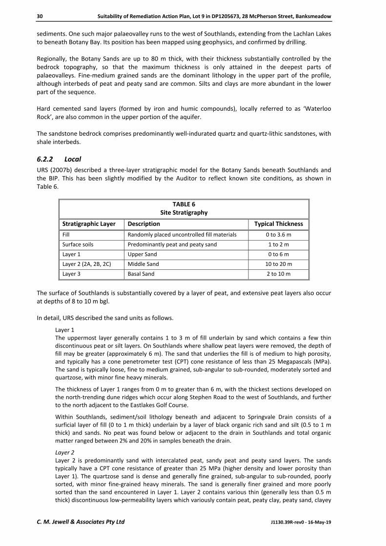
30 Suitability of Remediation Action Plan, Lot 9 in DP1205673, 28 McPherson Street, Banksmeadow
C. M. Jewell & Associates Pty Ltd J1130.39R‐rev0 ‐ 16‐May‐19
sediments. One such major palaeovalley runs to the west of Southlands, extending from the Lachlan Lakes to beneath Botany Bay. Its position has been mapped using geophysics, and confirmed by drilling. Regionally, the Botany Sands are up to 80 m thick, with their thickness substantially controlled by the bedrock topography, so that the maximum thickness is only attained in the deepest parts of palaeovalleys. Fine‐medium grained sands are the dominant lithology in the upper part of the profile, although interbeds of peat and peaty sand are common. Silts and clays are more abundant in the lower part of the sequence. Hard cemented sand layers (formed by iron and humic compounds), locally referred to as ‘Waterloo Rock’, are also common in the upper portion of the aquifer. The sandstone bedrock comprises predominantly well‐indurated quartz and quartz‐lithic sandstones, with shale interbeds.
6.2.2 Local
URS (2007b) described a three‐layer stratigraphic model for the Botany Sands beneath Southlands and the BIP. This has been slightly modified by the Auditor to reflect known site conditions, as shown in Table 6.
TABLE 6Site Stratigraphy
Stratigraphic Layer Description Typical Thickness
Fill Randomly placed uncontrolled fill materials 0 to 3.6 m
Surface soils Predominantly peat and peaty sand 1 to 2 m
Layer 1 Upper Sand 0 to 6 m
Layer 2 (2A, 2B, 2C) Middle Sand 10 to 20 m
Layer 3 Basal Sand 2 to 10 m
The surface of Southlands is substantially covered by a layer of peat, and extensive peat layers also occur at depths of 8 to 10 m bgl. In detail, URS described the sand units as follows.
Layer 1 The uppermost layer generally contains 1 to 3 m of fill underlain by sand which contains a few thin discontinuous peat or silt layers. On Southlands where shallow peat layers were removed, the depth of fill may be greater (approximately 6 m). The sand that underlies the fill is of medium to high porosity, and typically has a cone penetrometer test (CPT) cone resistance of less than 25 Megapascals (MPa). The sand is typically loose, fine to medium grained, sub‐angular to sub‐rounded, moderately sorted and quartzose, with minor fine heavy minerals.
The thickness of Layer 1 ranges from 0 m to greater than 6 m, with the thickest sections developed on the north‐trending dune ridges which occur along Stephen Road to the west of Southlands, and further to the north adjacent to the Eastlakes Golf Course.
Within Southlands, sediment/soil lithology beneath and adjacent to Springvale Drain consists of a surficial layer of fill (0 to 1 m thick) underlain by a layer of black organic rich sand and silt (0.5 to 1 m thick) and sands. No peat was found below or adjacent to the drain in Southlands and total organic matter ranged between 2% and 20% in samples beneath the drain.
Layer 2 Layer 2 is predominantly sand with intercalated peat, sandy peat and peaty sand layers. The sands typically have a CPT cone resistance of greater than 25 MPa (higher density and lower porosity than Layer 1). The quartzose sand is dense and generally fine grained, sub‐angular to sub‐rounded, poorly sorted, with minor fine‐grained heavy minerals. The sand is generally finer grained and more poorly sorted than the sand encountered in Layer 1. Layer 2 contains various thin (generally less than 0.5 m thick) discontinuous low‐permeability layers which variously contain peat, peaty clay, peaty sand, clayey

Suitability of Remediation Action Plan, Lot 9 in DP1205673, 28 McPherson Street, Banksmeadow 31
J1130.39R‐rev0 ‐ 16‐May‐19 C. M. Jewell & Associates Pty Ltd
sand and silty sand, depending on the localised depositional environment. The lateral extent of the various low‐permeability layers may range from less than 50 m to 500 m. The Botany Sands are commonly tightly packed at deeper levels.
Layer 2 is typically between 10 and 20 m thick, but ranges from less than 10 m thick over bedrock near the southern end of the BIP along Second Street, to over 30 m near the northern end of the BIP and in the lower reaches of the Lakes Valley Palaeochannel. The inferred surface of the top of Layer 2 dips from approximately 20 m AHD on the eastern margin of the Botany Basin to ‐0.6 m AHD.
As indicated above, Layer 2 has been further (evenly) divided into sub‐layers: Layer 2A, Layer 2B and Layer 2C. The division is also somewhat related to the general sequence of low permeability layers (and hydrogeology) inferred to exist within Layer 2.
Layer 3 Layer 3 is a basal zone of clayey sand and sandy clay with discontinuous layers of gravel, peat and peaty clay. The lithology of this layer is quite variable and reflects the various depositional environments. The top of Layer 3 is commonly characterised by the presence of organic rich layers which are commonly clayey and appear to be relatively continuous across the Botany area.
Beneath Southlands, Layer 3 is relatively thin (approximately 2 to 4 m), and is largely absent from the eastern part of the model area as the bedrock surface rises. To the west of the model area, where bedrock deepens, Layer 3 thickens (reflecting its estuarine and restricted lagoonal depositional environments) and contains clayey layers with sand lenses. In general, Layer 3 is typically less than 10 m thick, with the exception of the palaeochannels where Layer 3 thickens to over 30 m.
Whilst generally incorporated into Layer 3, there is also a deeper (fourth) unit of interbedded marine and estuarine shelly clays. Within the palaeochannels the sand and clays are underlain by basal sand, with some gravel of fluvial origin.
The groundwater system is shown in schematic cross‐section on Figure 5. The buried surface of the Hawkesbury Sandstone has been mapped in reasonable detail, using geophysical, cone penetrometer and borehole data; contours on this surface are shown on Figure 6. The most important features identified by URS are:
a broad basement valley beneath the northern end of the BIP that extends from Denison Street in a westerly direction beneath the former Polypropylene and Olefines II plants in the north‐western part of the BIP (directly north of Southlands Block 1), and merges into the Lakes Valley palaeochannel, which extends south to Botany Bay; and
a westerly trending basement ridge extending approximately under the southern portion of the BIP, immediately north of Southlands.
6.3 Hydrogeology
6.3.1 Groundwater Flow Regime
The Botany Sands contain a series of unconfined and semi‐confined aquifers that together are referred to as the Botany Sands Aquifer. Work by URS on the BIP, and by others elsewhere in the Botany Sands Aquifer, has made it clear that this is not a single aquifer, but a multi‐aquifer system containing many aquifer and aquitard units varying in hydraulic conductivity and in lateral and vertical extent. The aquifer units attain a degree of lateral continuity because of the discontinuous nature of the aquitards, and are interconnected vertically by leakage through the aquitards. Within the aquifer system as a whole, lateral groundwater flow is generally to the south‐west, under a hydraulic gradient of 0.008. However, in the past, changes and even reversals of the natural hydraulic gradient are assessed to have occurred as a result of concentrated groundwater pumping for industrial purposes. Between the 1950s and 1980s, groundwater flow in the vicinity of the BIP may have been towards the north and north‐west, due to heavy pumping from the Davis Gelatine wellfield.

32 Suitability of Remediation Action Plan, Lot 9 in DP1205673, 28 McPherson Street, Banksmeadow
C. M. Jewell & Associates Pty Ltd J1130.39R‐rev0 ‐ 16‐May‐19
The direction of the vertical hydraulic gradient and consequent groundwater flow varies with location in the aquifer, being downwards in the recharge areas around Centennial Park and Moore Park in the north, and upwards in discharge areas around and beneath the Alexandra Canal and Botany Bay. It is also affected by local pumping. Groundwater flow direction in the vicinity of the Southlands is now strongly influenced by pumping from the primary containment area (PCA), located along the southern boundary of Southlands adjacent to McPherson Street, and the secondary containment area (SCA), located along the centre of Foreshore Drive, south of Southlands. On Southlands, prior to operation of the PCA wells, shallow groundwater was estimated to discharge to Springvale and Floodvale drains at rates between 1.6 and 3 megalitres per day (ML/d), implying upward vertical flow. Although some downward flow from the shallow aquifer to the deeper aquifers would be expected as a consequence of pumping from the PCA wells located around the southern edge of Southlands, hydrograph data from 2007 and early 2008 indicated that there had been little effect on shallow groundwater levels. However, it is likely that there would be a significant lag due to system storage. Groundwater pumping to the GTP during the period October 2011 to September 2013 averaged 4.8 ML/d. About 40% of this would be attributable to the PCA located along the southern boundary of Southlands. The PCA pumping captures most flow in the deeper aquifer beneath Southlands. Both deep and shallow aquifer flow are captured by the SCA. Groundwater discharge to Springvale Drain is now intermittent.
6.3.2 Groundwater Levels
Groundwater levels in the shallow aquifer beneath Southlands fluctuate with rainfall but were typically from a few centimetres to 3 m bgl (3.5 to 1.0 m AHD).
6.3.3 Hydraulic Characteristics
Table 7 shows the ranges of hydraulic conductivity and porosity reported by URS (2007b).
TABLE 7Hydraulic Characteristics
Stratigraphic Layer Average Measured
Hydraulic Conductivity (m/d)
Average Hydraulic Conductivity derived
from Model Calibration (m/d)
Porosity Storativity Specific Yield
Layer 1 (shallow aquifer)
18 14 0.37 ‐ 0.20 – 0.28
Layer 2 (2A, 2B, 2C) (deep aquifers)
23 26 0.30 0.001 – 0.005
‐
Layer 3 1.2 1.0 0.35 0.001 – 0.003
‐
Note: m/d metre per day
Groundwater flow modelling at Southlands has been carried out by Merrick (2004) and Laase (2005). A vertical anisotropy factor of 0.1 (vertical hydraulic conductivity 1/10 of lateral hydraulic conductivity) was used in the most recent modelling. The model calibration also indicates that low hydraulic conductivity (2 to 10 m/d) is present in the south‐east corner of Southlands.

Suitability of Remediation Action Plan, Lot 9 in DP1205673, 28 McPherson Street, Banksmeadow 33
J1130.39R‐rev0 ‐ 16‐May‐19 C. M. Jewell & Associates Pty Ltd
6.4 Groundwater and Surface Water Interaction near the Springvale Drain
JBS (2013) compiled a review of interaction between groundwater and surface water at Southlands, using data collected before and after the commencement of pumping from the PCA and SCA to the GTP. Prior to commencement of pumping, the mechanism for transport of contaminants from groundwater to surface water in Springvale Drain was described by WWC (1996) as:
under non‐pumping conditions groundwater from the shallow aquifer discharges to the drain; and
there is an upward hydraulic gradient from the intermediate/deep aquifer into the shallow aquifer with the potential for discharge of deeper groundwater to the drain.
During GTP operation the upward gradient reverses and there is a downward gradient from the shallow to deep aquifer. In addition to the change in gradient, shallow groundwater levels are often below the invert of Springvale Drain. As a result, the drain becomes a source of groundwater recharge and allows relatively clean surface water to overlie deeper groundwater along the alignment of the drain. Combined with the reversed vertical gradient during groundwater extraction a significant lens of relatively clean groundwater is now present surrounding Springvale Drain (noting that similar processes also occurred in the depressions on Block 1). In general, shallow groundwater at Southlands is now significantly less contaminated than deeper groundwater. The conceptual model of groundwater flow at Springvale Drain identifies the presence of a freshwater lens beneath and adjacent to the drain. This lens is the result of operation of the GTP which lowers deep groundwater levels and induces recharge from rainfall and flow in the drain. When the GTP is not operating groundwater levels in the deep aquifer increase and flow is induced from the deep aquifer into the shallow system which then discharges to Springvale Drain. It is unclear the period of time after a GTP shutdown that deeper groundwater begins to significantly affect discharge although current information indicates that it is greater than 6 months but likely to be less than 3 years. A review of surface water and groundwater concentrations indicates that significant decreases have been observed since commencement of GTP operation. It is considered that total CHC concentrations in surface water that may occur after extended GTP shutdowns will be approximately 25% of those observed in the period prior to commissioning of the GTP. Some additional detail is as follows:
The largest decreases are for EDC and VC. Concentrations of EDC will be significantly less (an order of magnitude) than prior to GTP operation. VC concentrations will also be lower (as these were largely associated with the Central Plume).
Concentrations of the stickier compounds (CTC, PCE and TCE) will only be slightly lower than those observed prior to GTP operation. This is a result of their slow migration in the subsurface but also the fact that they are likely to be present in DNAPL.
The most significant groundwater concentration decreases have occurred for wells at the northern end of Springvale Drain (where the sticky compounds were less prevalent).
The surface water results indicate that the highest concentrations are now present at the northern end of Springvale Drain (whereas historically concentrations increased down the drain) although total concentrations are significantly less than historically observed.
6.5 Site Contamination Issues
Southlands has been the subject of random and uncontrolled placement of fill materials, and the disposal of liquid and sludge wastes in the paper‐waste ponds and elsewhere. In addition to a wide range of natural materials, fill deposits include ash from Bunnerong Power Station, and building rubble and demolition wastes including brick, concrete, timber and ACM.

34 Suitability of Remediation Action Plan, Lot 9 in DP1205673, 28 McPherson Street, Banksmeadow
C. M. Jewell & Associates Pty Ltd J1130.39R‐rev0 ‐ 16‐May‐19
Previous industrial and waste management practices on the former ICI site (land that is now predominantly the BIP, but also the northern part of Block 1 of Southlands) resulted in extensive contamination of groundwater by CHCs and some metals. Some of these materials are DNAPL, and secondary sources of contamination including residual and separate‐phase (pooled) DNAPL remain beneath some parts of the BIP, and beneath the northern part of Block 1. Extensive dissolved‐phase plumes of CHC traverse the shallow, intermediate and deep aquifers beneath both Block 1 and Block 2. Many of the CHC are volatile, and vapour‐phase materials are evolved from the dissolved phase plumes and impacted soils, and may migrate upwards through the vadose zone to be emitted at the ground surface. Shallow groundwater contaminated with CHC has in the past discharged to surface water bodies such as Springvale Drain, whence vapour emissions to the atmosphere occurred. Following reversal of the vertical hydraulic gradient due to operation of the pumping systems feeding the GTP, such discharge no longer occurs whilst the GTP is operating.
6.6 Contaminants of Potential Concern
COPC were identified progressively from the results of the investigations summarised in Section 4 of this SAR. Earlier work has now been substantially superseded by EnRiskS (2015 and 2019) and therefore detailed discussion of COPC in soil and soil gas is provided in Section 7 of this SAR. The main contaminants identified in groundwater are derived from the extensive plumes that emanate from the BIP. These plumes have been characterised on the basis of their origin and principal contaminant components, and are shown on Figure 7. Southlands is impacted by the central plumes identified at the BIP, which are dominated by:
EDC;
PCE;
TCE; and
VC; and by the southern plumes, which are dominated by:
CTC;
PCE;
TCE; and
VC. However, a range of other chemicals that have been reported in groundwater may be derived from former operations at the BIP as well as surrounding industrial areas. The investigations carried out in 1996 by WWC also reported the presence of DNAPL at depth within the northern portion of Block 1; subsequent delineation work was carried out by URS to define the limits of the DNAPL. This residual/ pooled DNAPL is regarded as a source area. Further discussion of the current status of groundwater contamination is provided in Section 7.
6.7 Updated CSM (Orica 2017)
An updated CSM (Orica 2017) has recently been prepared for the BIP, including the site and surrounding areas. As previously recognised, it concluded that groundwater beneath the site has potentially been impacted by VOCs and SVOCs from contaminated soils that had been located on BIP land. The depth to groundwater is approximately 8 m beneath the site. Potential future site receptors include on‐site workers, and maintenance workers that undertake intrusive works at the site for repair or maintenance of buried services, and construction workers associated with

Suitability of Remediation Action Plan, Lot 9 in DP1205673, 28 McPherson Street, Banksmeadow 35
J1130.39R‐rev0 ‐ 16‐May‐19 C. M. Jewell & Associates Pty Ltd
site redevelopment. Potential exposure pathways, noting that contact with groundwater is unlikely due to its depth and regulatory controls on its use, include contact with impacted soils; ingestion of impacted soil: inhalation of potential contaminants in soil such as asbestos fibres; and inhalation of soil vapour from impacted soil and groundwater. The Auditor considered that in conjunction with the previous investigations completed on Block 1, this CSM formed an appropriate basis for the site assessment and risk assessment work on Lot 9 that is reviewed in this SAR.

36 Suitability of Remediation Action Plan, Lot 9 in DP1205673, 28 McPherson Street, Banksmeadow
C. M. Jewell & Associates Pty Ltd J1130.39R‐rev0 ‐ 16‐May‐19
7.0 HUMAN HEALTH RISK ASSESSMENT
URS completed a human health risk assessment (HHRA) in 2008 (URS 2008d) that considered a range of specific aspects associated with the then‐proposed development and staged remediation of Southlands. However, following completion of the 2008 HHRA and prior to finalisation of the Block 1 RAP, the proposed redevelopment scenarios/stages and details specific to the proposed development changed. In addition, some further information became available in relation to the characterisation of risk on Southlands. Therefore, in November 2013, EnRiskS prepared a Revised Human Health Risk Assessment for the Southlands project, relating specifically to the development of Block 2, located to the west of Lot 9, and in 2015 EnRiskS was engaged to provide a revised HHRA (EnRiskS 2015) of part of Block 1 (that within Lot 10 in DP1205673, since subdived into Lots 100 and 101 in DP1223909) located to the east of Block 9, wherein the revised project development and additional information was considered. As the Block 1 HHRA did not include any assessment of commercial/industrial development relating to Lot 9 in DP1205673, in 2019 Orica engaged EnRiskS to provide an addendum to the 2015 HHRA that included:
a quantitive assessment of potential risks to human health associated with the proposed development of the flood detention basin located on Lot 9 (i.e. building construction on a suspended slab with a large open void beneath); and
depending on the outcome of the HHRA, identify issues that require risk mitigation measures to be considered in the proposed development.
As the HHRA Revision is considered to be an addendum to the Block 1 HHRA, a summary of both the background information provided in the Block 1 HHRA (EnRiskS 2015) and the risk assessment relating specifically to Lot 9 provided in the HHRA Revision (EnRiskS 2019) are provided in this section of the SAR. The checklist completed by the Auditor during his review of the HHRA is provided in Appendix D of this SAR.
7.1 Methodology
The approach taken by EnRiskS (2015, 2019) to the quantitative assessment of human health risks was in accordance with the protocols and guidelines as outlined in the following:
Environmental Health Risk Assessment, Guidelines for Assessing Human Health Risks from Environmental Hazards (enHealth 2012a);
Australian Exposure Factors Guide (enHealth 2012b);
Schedule B4, Guideline on Health Risk Assessment Methodology (ASC NEPM);
Schedule B6, Guideline on Risk‐Based Assessment of Groundwater Contamination (ASC NEPM); and
Schedule B7, Guideline on Health‐Based Investigation Levels (ASC NEPM). In addition to the above, guidance was obtained from USEPA (1989, 1991, 1996, 2002, 2004a, 2004b, 2009) and WHO (2008). The Auditor notes that the enHealth and ASC NEPM documents are approved by the EPA under the provisions of Section 105 of the CLM Act. EnRiskS (2019) also considered the available information and data provided in the following:
proposed development plans prepared by Axis Architectural, dated January 2018 (i.e. construction of two commercial/industrial warehouses, with office areas but no more‐sensitive uses such as childcare, on a raised concrete deck built above the existing flood detention basin);
soil vapour data at locations sampled by JBS&G within the flood detention basin in 2018; and
groundwater and surface water data available to September 2018, reported by Golder (2018).

Suitability of Remediation Action Plan, Lot 9 in DP1205673, 28 McPherson Street, Banksmeadow 37
J1130.39R‐rev0 ‐ 16‐May‐19 C. M. Jewell & Associates Pty Ltd
The various guideline documents indicated above describe the standard approach to risk assessment, under which the conduct of an HHRA can be divided into the following four primary tasks.
1. Issue Identification
2. Exposure Assessment
3. Hazard/Toxicity Assessment
4. Risk Characterisation. There is also a fifth task that may be considered:
5. Risk Management.
7.2 Risk Issues on Block 1
Block 1 included a number of locations where CHC were detected in soil. While remediation extended to a depth where groundwater was intersected, the lateral extent of remediation was determined through the use of criteria relating to volatile impacts that may remain in outdoor areas, not beneath a future building. While the validation of excavations in this area had shown no detections of volatile chemicals following excavation, the potential for vapour intrusion (into a building) risk issues had been addressed through the collection of soil vapour data. Any residual soil impacts that have the potential to affect vapour intrusion risks had thus been addressed because such impacts would have contributed to the vapour concentrations measured.
7.2.1 Review of Groundwater Data
In September 2003, the EPA issued a Notice of Clean‐up Action (NCUA) No. 1030236 to Orica requiring remediation of the CHC contaminant plumes emanating from the BIP and present in areas to the south and west of BIP. The NCUA required the preparation and implementation of a more extensive groundwater monitoring program than that which was being undertaken at the time. The expanded monitoring program was documented in a Groundwater Clean‐up Plan (GCP) (2003) and included installation of monitoring wells/bundled piezometers, and sampling and reporting of analytical data on a quarterly basis. The GCP documented the proposed strategies adopted to address groundwater contamination at BIP and downgradient of BIP. The strategy selected to achieve hydraulic containment of groundwater contamination was described in the Botany Groundwater Cleanup Project Environmental Impact Statement (URS 2004c) and comprised the installation and operation of three hydraulic containment lines (BIP, primary (PCL) and secondary) to achieve hydraulic containment and construction of a GTP to enable treatment of extracted groundwater. Specifically, in relation to Southlands, there are a number of extraction wells and associated pipework associated with the PCL that are located along the southern boundary of Block 2 and part of Block 1. In 2010, the NCUA was revoked by the EPA. At the same time the EPA issued a notice of approval for a Voluntary Management Proposal (VMP) that replaced the NCUA. That approval was in turn replaced by an approval to a new VMP, issued on 12 August 2015, most recently amended on 19 June 2017. Operation of the Groundwater Treatment Plant EnRiskS’s (2015) comparison of recent and historic groundwater quality data showed a decrease (approximately 2 orders of magnitude) in CHC concentrations of shallow sampling locations near Springvale Drain since the commencement of operation of the hydraulic containment scheme. The decrease is significant and is associated with both plume migration and the development of a downward vertical gradient and associated freshwater lens creation due to hydraulic containment pumping. The Auditor has checked the most recent monitoring data; these conditions have been maintained. The only exposure pathway associated with the presence of contamination in groundwater beneath Block 1, including Lot 9, that EnRiskS (2015, 2019) considered complete was the inhalation of vapours

38 Suitability of Remediation Action Plan, Lot 9 in DP1205673, 28 McPherson Street, Banksmeadow
C. M. Jewell & Associates Pty Ltd J1130.39R‐rev0 ‐ 16‐May‐19
originating from volatile chemicals that may be present close to the water table formed by groundwater within the shallow aquifer (i.e. the upper surface of the phreatic zone and the capillary fringe within the vadose zone). Such inhalation could occur following vapour migration through overlying soils into the proposed buildings, outdoor air (to a lesser extent) and excavations. Groundwater Treatment Plant Not Operating In the event that the GTP is permanently shut down, it is expected that the EPA would require installation of alternative measures to meet the requirements of the NCUA, in particular that risks to human health and the environment (associated with all relevant exposure pathways) in areas located off site from the BIP remain low and acceptable. This would include exposure to workers within all areas of the proposed Southlands development. If the situation arose where the GTP was to be temporarily shut‐down for an extended period of time there could be potential for changes in shallow groundwater concentrations to occur, with consequent and vapour intrusion risks. However, the identification of risk issues associated with the presence of volatile compounds (in soil and groundwater) as well as ground gases confirmed the need to implement vapour/gas mitigation beneath all buildings to be constructed on the site, as was indicated in the draft SAR (CMJA 2008). Because these measures would also adequately manage any variation in vapour concentrations derived from shallow groundwater that may occur following a GTP shutdown, no further detailed assessment of risk issues derived from shallow groundwater associated with a GTP shutdown was carried out by EnRiskS or presented in the HHRA.
7.2.2 Review of Soil Gas and Flux Emissions Data
EnRiskS carried out a review of the results of soil vapour monitoring carried out in February 2015 (JBS&G 2015a) and additional soil vapour sampling carried out in May 2015 (JBS&G 2015c). The locations identified by JBS&G were considered to be representative of locations likely to be beneath future commercial/industrial buildings on Lot 10 (now Lots 100 and 101 in DP1223909). EnRiskS’s review of ground gas data indicated the presence of elevated and variable concentrations (at some locations) of both methane and carbon dioxide. For most locations, the pressure and flow rate data indicated that methane and carbon dioxide are not being generated at any significant rate. However, at SV6, the sampling conducted in May 2015 identified a flow rate that was not considered negligible (reported on two consecutive days of sampling); flow rates on all other sampling days were negligible. EnRiskS assessed that where no pressure driven flow is occurring in the subsurface, the levels of methane and carbon dioxide will attenuate through the overlying soil, with methane expected to biodegrade.
7.2.3 Exposure Pathways ‐ Specifically Related to Lot 9
Based on the information available at the time, EnRiskS (2015) identified the following risk issues that may warrant further consideration in relation to the proposed development on Lot 9:
direct contact with soil;
inhalation of vapours that may be derived from the migration of volatile contaminants in shallow groundwater beneath the site into the proposed buildings (i.e. vapour intrusion);
inhalation of vapours that may migrate onto Lot 9 from the presence of volatile chemicals in surface water within Springvale Drain, located on the western side of Nant Street; and
exposure to hazards associated with landfill gas in the subsurface beneath the site and other areas of Block 1 to the east.
Enrisks (2019) noted that based on the proposed development there will be no potential for any direct contact with groundwater or flood water. In addition, EnRiskS acknowledged that an appropriate management plan would be implemented to manage risk to construction and other intrusive maintenance workers from exposure to subsurface contamination on the site, and these potential exposures were therefore not considered in EnRiskS (2019).

Suitability of Remediation Action Plan, Lot 9 in DP1205673, 28 McPherson Street, Banksmeadow 39
J1130.39R‐rev0 ‐ 16‐May‐19 C. M. Jewell & Associates Pty Ltd
7.3 Assessment of Risk – Asbestos
Following its review of available data, EnRiskS (2015) concluded that asbestos materials were present in soil on Block 1, and may be in the form of bonded ACM, FA and AF. Asbestos in soil only poses a risk to human health when asbestos fibres are made airborne and inhaled (if asbestos is bound in a matrix, it is not readily made airborne except through substantial physical damage). ACM in sound condition represents a low human health risk. However, both FA and AF materials have the potential to generate, or be associated with, free asbestos fibres that may become airborne as a result of wind erosion or disturbance. On this basis, a methodology for the assessment of asbestos in soil is presented in the ASC NEPM guidelines. This approach combines management with the use of risk‐based criteria for a range of land‐use scenarios. In particular, the following approach for addressing long‐term exposures to asbestos materials in soil is recommended therein.
If visible asbestos is present and it may be disturbed during work activities, it must be removed. This includes removing visible fragments of bonded ACM from exposed trench faces and those areas of the site where intrusive works may be carried out.
No visible asbestos materials should be present in the top 10 cm of the site (this is the top 10 cm of the final ground surface level) or to a depth which may be excavated and moved on the site during future development. If it is not possible to remove visible asbestos from all depths relevant to future excavation activities, these materials may be placed beneath the proposed buildings or hardstand areas, or placed at appropriate safe depth and subject to an appropriate long‐term site management plan to identify and manage the potential presence of asbestos materials in soil in these areas.
The soil investigation criterion for ACM relevant to the commercial/industrial use of the site is 0.05% weight per weight (w/w). For the presence of FA and AF in soil, a guideline of 0.001% has been established for all land uses. These criteria are based on calculations presented in the Guidelines for the Assessment, Remediation and Management of Asbestos‐Contaminated Sites in Western Australia (WA DOH 2009) guidance. Specifically, the guidelines for ACM were derived on the basis of the following:
- As the inhalation pathway is the only pathway of concern, the guidelines have adopted the WHO (2000) asbestos air guideline of 0.001 fibres per millilitre (f/ml) which is associated with a 10‐5 to 10‐6 risk for lung cancer. WHO notes that mesothelioma risk is about 10 times the risk of lung cancer and since the WHO air guideline is based on lung cancer a 10‐fold factor has been included by the WA DOH to establish an air guideline of 0.0001 f/ml that is based on a 10‐5 to 10‐6 risk for mesothelioma. WA DOH (2009) states that this level of increased risk is considered acceptable.
- The movement of asbestos fibres from soil to air has been assessed on the basis of the study conducted by Swartjes et al (2003) and Swartjes & Tromp (2008). These studies indicate that maintaining a concentration below 0.01% w/w for fibrous asbestos in soil keeps asbestos fibres in air below 0.001 f/ml (WHO 2000) and probably below 0.0001 f/ml (WA DOH 2009). Similarly for non‐friable ACM a value of 0.1% w/w in soil will keep asbestos in fibres below the WA DOH air guideline.
- The WA DOH added in a 10 fold factor to account for drier soil in Western Australia as compared to Western Europe. This resulted in the derivation of a guideline of 0.001% w/w for FA and AF. This guideline has been set to the same value for all land use scenarios.
- For ACM, the soil guideline (including the 10‐fold factor) is 0.01% w/w for low‐density residential land use. This value has been multiplied by the land use factors adopted in the ASC NEPM HILs to establish criteria for other land‐uses including commercial/ industrial (where a 5‐fold factor has been used to derive a criterion of 0.05%).
As the inhalation pathway is the only pathway of concern for the assessment of asbestos exposure, potential exposures by workers (who are assumed to be exposed 8 hours per day for 240 days of the year, compared with residents who are assumed to be exposed 24 hours per day for 365 days

40 Suitability of Remediation Action Plan, Lot 9 in DP1205673, 28 McPherson Street, Banksmeadow
C. M. Jewell & Associates Pty Ltd J1130.39R‐rev0 ‐ 16‐May‐19
of the year) are approximately 5 times lower than for residents. Hence the application of the 5 fold factor in the derivation of the commercial/industrial criteria for ACM is reasonable.
Soil data for Block 1 indicate the presence of asbestos fibres in a fragment of bonded fibrous cement, in stockpiled materials. The available data do not suggest that ACM or FA/AF are widespread across Block 1; however this is based on a limited number of samples.
7.3.1 Assessment of Risk ‐ Asbestos ‐ Specifically Related to Lot 9
As the proposed development will be raised on a suspended concrete platform, 2.5 m above the flood detention basin, there will not be any site‐related soil accessible for these workers. On this basis, EnRiskS (2019) concluded that workers within the proposed development will have no potential for direct contact with soil. In the landscaped setback areas around the perimeter of the raised concrete platform, some site‐related soil will be accessible to workers who may undertaken gardening or landscaping activities. Accessible soil within Lot 9 was remediated in 2014 (JBS&G 2015d), with the soil validated as suitable for commercial/industrial use. Therefore, EnRiskS (2019) concluded that any direct contact exposures that may occur for these workers (which would likely be infrequent) are not considered to be of concern.
7.4 Assessment of Risk – Vapour Intrusion
The only exposure pathway associated with the presence of contamination in groundwater beneath Block 1 that is considered complete is the inhalation of vapours from volatile chemicals that may be present at the surface of the groundwater (shallow aquifer), following vapour migration through overlying soils into the proposed buildings (and to a lesser extent outdoors). As the assessment of risk for vapour intrusion in the Block 1 HHRA (EnRiskS 2015) relates specifically to the development of Blocks 100 and 100 in DP1223909 (i.e. commercial/industrial buildings constructed on a slab, with no basements permitted), it is not considered relevant to Lot 9. A summary of the vapour intrusion risks described in HHRA (2019) are summarised below.
7.4.1 Vapour Intrusion from Groundwater
The potential for soil vapours to migrate into the proposed buildings is considered to be low as the development will be constructed on a raised concrete platform, that allows for the mixing and dilution of vapours in the 2.5 m high area above the flood detention basin, beneath the concrete platform. The flood detention basin will not intersect shallow groundwater and is therefore not considered to be a preferential pathway for the movement of volatile chemicals closer to the proposed development. The depth to groundwater beneath the flood detention basin will remain beneath the ground surface. Any intrusive works to be conducted in these areas will be required to be undertaken in accordance with a construction environmental management plan (CEMP) that addresses the potential presence of shallow contaminated groundwater. EnRiskS noted that when the flood detention basin is managing surface water runoff (not assumed to be contaminated), this will saturate the soil within the basin, preventing the migration of vapours from the underlying groundwater diffusing to the ground surface (as this needs to occur through the air pores within an unsaturated zone). Under these conditions the vapour intrusion pathway will be incomplete. It is not known how often, and for how long soil within the detention basin will be saturated with surface water runoff. EnRiskS reviewed the available soil vapour data from Lot 9 to evaluate the potential vapour risk issues related to vapour intrusion from groundwater, where the flood detention basin is dry. Soil vapour was sampled from six locations on Lot 9 in 2018 (JBS&G 2018b). The sample locations were generally equally spread beneath Lot 9, with the highest concentrations of CHCs reported in SV3 located in the northern part of Lot 9. The soil vapour wells have been sampled on one occasion.

Suitability of Remediation Action Plan, Lot 9 in DP1205673, 28 McPherson Street, Banksmeadow 41
J1130.39R‐rev0 ‐ 16‐May‐19 C. M. Jewell & Associates Pty Ltd
The maximum concentrations reported in soil vapour have been summarised in Table 8, with these compared against relevant soil vapour screening criteria for commercial/industrial buildings a slab on grade. The screening criteria are consistent with those adopted in the Block 1 HHRA and have been updated, where relevant, based on any updates to guidance. The VOCs listed in Table 8 are those detected and screened in the Block 1 HHRA. Some of these VOCs were not detected beneath Lot 9, however as they were detected in other adjacent lots the analytical limit of reporting (LOR) has been included for the purpose of screening.

42 Suitability of Remediation Action Plan, Lot 9 in DP1205673, 28 McPherson Street, Banksmeadow
C. M. Jewell & Associates Pty Ltd J1130.39R‐rev0 ‐ 16‐May‐19
TABLE 8 Summary and Review of Soil Vapour Data ‐ Lot 9 (µg/m3)
VOC Detected Maximum Concentration reported (LOR where the LOR is elevated for
SV03)
Soil Vapour Screening Criteria (Commercial/Industrial Land Use)
ethyl acetate ‐ (<90) 31,000A2
tetrahydrofuran ‐ (<70) 880,000A2
propylene ‐ (<43) 13,000A2
heptane ‐ (<100) 310,000 (adopted value for hexane)
hexane 23 (<90) 310,000A2
hydrogen sulphide not analysed 880A2
ethanol ‐ (<500) 5,124A4
isopropyl alcohol 4800* 88,000A2
1,1,1‐trichloroethane ‐ (<140) 230,000N
1,1,2,2‐tetrachloroethane 4 (<170) 210A2
1,1,2‐trichloroethane 5 (<140) 88A2
1,1‐dichloroethane 19,000 16,500A3
EDC ‐ (<100) 920A1
carbon tetrachloride 5 (<160) 610A1
chloroform 20 (<120) 64,000A1
chloroethane ‐ (<70) 4,400,000A2
PCE 58 (<170) 8,000N
1,1‐DCE 120 92,000A1
cis‐1,2‐DCE 28 (<100) 300N
trans‐1,2‐DCE 7 (<100) 3,000N*
trichloroethene 76 (<130) 80N
VC ‐ (<60) 100N
2‐butanone (MEK) ‐ (<70) 2,200,000A2
cyclohexane ‐ (<90) 440,000A2
1,2,4‐trimethylbenzene 4 (<120) 26,000A2
1,3,5‐trimethylbenzene ‐ (<120) 26,000A2
styrene ‐ (<110) 26,000A1
naphthalene 4 (<130) 1,300A2
benzene 3 (<80) 10,000H
toluene 8 (<90) 16,000,000H
ethylbenzene 10 (<110) 4,600,000H
xylene (m&p) 94 (<220) 3,200,000H
xylene (o) 49 (<110) 3,200,000H
C6‐C10 less BTEX (F1) ‐ (<1000) 2,800,000H
>C10‐C16 less naphthalene (F2) ‐ (<2000) 2,400,000H
carbon disulfide ‐ (<80) 100,000A1
hexachlorobutadiene ‐ (<270) 560A2
1,4‐dioxane 6 (<90) 250A2
2‐propanone (acetone) 50 (<600) 14,000,000A2
* Detection of isopropyl alcohol likely to reflect the use of this chemicals for leak detection during the sampling N NEPM Interim HIL for soil vapour, commercial/industrial land use (ASC NEPM) N* Criteria for trans‐1,2‐DCE based on the NEPM Interim HIL for cis‐1,2‐DCE with the application of 10 fold factor as the toxicity of
the trans‐isomer is 10 times lower than for the cis‐isomer (as per USEPA review) H NEPM Health Screening Level (HSL) (ASC NEPM) for petroleum hydrocarbons, soil vapour HSLs for vapours 1 to <2m depth with
sand overlying, commercial/industrial land use A Soil vapour criteria modified from ambient air criteria by the application of 100 fold attenuation factor. The ambient air
guidelines are adopted from the following sources: 1 Air quality criteria or guideline value available from WHO, based on annual average. Where criteria is derived on the basis of
a non‐threshold approach a target risk of 1x10‐5 is adopted. To address exposures by workers a correction factor of 4.6 has been applied to adjust for working 8 h/d for 240 d/y over a lifetime.
2 Industrial air RSL available from USEPA (USEPA 2018), based on annual average. Where criteria is derived on the basis of a non‐threshold approach a target risk of 1x10‐5 is adopted.
3 Chronic Reference Exposure Level established by Ontario Ministry of the Environment. 4 Chronic air guideline available from the Massachusetts Department of Energy and Environmental Affairs
http://www.mass.gov/eea/agencies/massdep/toxics/sources/air‐guideline‐values.html

Suitability of Remediation Action Plan, Lot 9 in DP1205673, 28 McPherson Street, Banksmeadow 43
J1130.39R‐rev0 ‐ 16‐May‐19 C. M. Jewell & Associates Pty Ltd
A review of the results for Lot 9 indicates that the maximum concentration of 1,1‐dichloroethane reported in soil vapour exceeds the screening criteria adopted. Even where the elevated LOR reported in SV3 is considered, no other volatile chemicals exceed the adopted screening criteria. EnRiskS noted that the general commercial/industrial screening criteria are overly conservative for the assessment of vapour intrusion into the proposed development. This is the case because the proposed development is constructed on a concrete slab raised 2.5 m above the ground surface. The ground is exposed and the sub‐floor area is well ventilated. This will probably result in the effective dispersion of any vapours that are emitted to air from the ground surface, however it could be conservatively assumed that the mixing that may occur in the sub‐floor are results an additional 10 fold factor for attenuation. This is the same factor as would be conservatively assumed for the movement of vapours from a basement into the ground floor of a multi‐storey building. The value is also lower than the factor of 14 determined from the measurement of tracer gas movements in 700 Dutch residential homes with crawl‐spaces below a suspended concrete slab (noting that these are low crawl‐spaces that are enclosed) (Otte et al. 2001; Van den Berg 1994). The actual additional attenuation is expected to be greater than this as the sub‐floor is well ventilated to ambient air (with a high sub‐floor space), rather than being enclosed and well‐connected with upper floors as would be the case with a basement or a crawl‐space residential home in a colder climate. Where an additional 10‐fold attenuation is assumed, to account for the well‐ventilated sub‐floor, the screening criteria for 1,1‐dichloroethane increases to 165,000 μg/m3. The maximum concentrations detected (19,000 μg/m3) is well below this modified criteria. It is noted that higher concentrations of soil vapour were reported in the soil vapour wells located adjacent to Lot 9, and assessed in the Block 1 HHRA (EnRiskS 2015). The Block 1 HHRA identified a large number of CHCs that required further assessment in relation to vapour intrusion risks, into a slab‐on‐grade commercial/industrial premises. The risk calculations undertaken and presented in the Block 1 HHRA determined that the nonthreshold risks were low and acceptable, however the maximum threshold hazard index (HI) was 2.3 (based on data collected from Lot 8). Where an additional attenuation factor of 10‐fold is assumed (as above) for the presence of a large well‐ventilated sub‐floor void beneath the slab, the HI is reduced to 0.23, which is considered acceptable. Hence, even where these higher soil vapour concentrations are considered there are no vapour risk issues of concern for the proposed development. On this basis, EnRiskS (2019) concluded that there are no vapour intrusion risk issues of concern, where the flood compensation basin is not managing surface water and the soil between groundwater and the development is dry. In the event that the GTP is shut down, it is expected that the EPA would require the installation of alternative measures to meet the requirements of the NCUA, in particular that risks to human health and the environment (associated with all relevant exposure pathways) in areas located off‐site from the BIP are low and acceptable. This would include exposures by workers within all areas of the proposed development.
7.4.2 Vapour Intrusion from Springvale Drain
Based on the proposed development plans, any building to be constructed on Lot 9 will be at least 20 m away from Springvale Drain, noting that Warehouse 2 is 5 m from the boundary of Lot 9, the Nant Street roadway is approximately 10 m and Springvale Drain is at least another 5 m to the west of Nant Street. A detailed assessment of vapour risks derived from the presence of VOCs in surface water within Springvale Drain (when the GTP is operating as well as when the GTP is not operating) was undertaken and presented in the Block 2 HHRA (EnRiskS 2013). This evaluation determined that vapour inhalation risks posed to workers in buildings located at least 20 m from the drain are not considered to be of concern. As the section of Springvale Drain considered in the Block 2 HHRA is the same as for this assessment, the assessment is considered applicable to potential exposures by workers in buildings within Lot 9. On this basis, EnRiskS concluded that no further assessment of potential vapour inhalation exposures derived from Springvale Drain is required.

44 Suitability of Remediation Action Plan, Lot 9 in DP1205673, 28 McPherson Street, Banksmeadow
C. M. Jewell & Associates Pty Ltd J1130.39R‐rev0 ‐ 16‐May‐19
EnRiskS noted that review of the available surface water and air data from Springvale Drain indicates that since the GTP has been operating, there is a significant amount of time (93% of the time between 2007 and 2012) when shallow groundwater is not being discharged to the drain, and there are no vapour exposures relevant to surface water within the drain. Hence the assessment presented in the Block 2 HHRA was expected to be conservative while the GTP is operating.
7.4.3 Assessment of Risk – Ground Gas
The Block 1 HHRA (EnRiskS 2015) identified the presence of elevated levels of methane and carbon dioxide in the subsurface, in a number of areas proposed to be developed (not Lot 9). There were some areas where these elevated levels occurred with significant levels of gas flow. It is inferred that the elevated levels are associated with the degradation of paper waste materials historically dumped in these areas. The issue of concern in relation to the presence of elevated concentrations of methane and carbon dioxide in the subsurface is the movement of these gases into future buildings. The gases have the potential to pose an asphyxiate or explosive risk. These gases are not generated such that there is significant pressure driven/advective gas movement at most locations. The soil vapour sampling undertaken within Lot 9 (BS&G 2018b) included analysis for methane and carbon dioxide. No methane was detected in the samples collected. Carbon dioxide was reported to be at a level between 2.3 and 13%. These levels of carbon dioxide are above background but consistent with the degradation of organic matter in the subsurface. No landfill gas bores were installed or sampled from Lot 9. While no methane was detected in the soil vapour samples collected from Lot 9, elevated levels were reported in the adjacent lots (to the east of Lot 9) and some lateral migration of landfill gas may occur particularly close to the eastern boundary of Lot 9. For the Lots assessed in the Block 1 HHRA (EnRiskS 2015), the landfill gas data suggested gas characteristic situation (CS) 1 to 2. Data from one location (SV6 in Lot 7) resulted in CS 4 due to significantly elevated methane and gas flows. This location is significantly to the east of Lot 9 and is not considered relevant for the proposed development. The development of Lot 9 includes a well‐ventilated sub‐floor that is 2.5 m high. This provides a very effective passive gas mitigation measure, that would meet the gas mitigation requirements outlined in the Block 1 HHRA where a CS of 2 may be present, and there are large commercial warehouse buildings resulting in the need for Level 1 gas protection based on EPA guidance (EPA 2012). Table 9 provides a summary of the guidance values for gas protection and Table 10 sets out the scores for protection measures, as described in EPA (2012). On this basis, EnRiskS concluded that there are no landfill gas risk issues of concern in relation to the proposed development of Lot 9.

Suitability of Remediation Action Plan, Lot 9 in DP1205673, 28 McPherson Street, Banksmeadow 45
J1130.39R‐rev0 ‐ 16‐May‐19 C. M. Jewell & Associates Pty Ltd
TABLE 9 Guidance Values for Gas Protection
CS
Required Gas Protection Guidance Value
Low Density Residential
Medium‐High Density Residential (Strata Title)
Public Buildings, Schools, Hospitals, Shopping Centres
Standard Commercial Buildings (Offices, etc.)
Large Commercial
(Warehousing) and Industrial Buildings
1 0 0 0 0 0
2 3 3 3 2 1(a)
3 4 3 3 2 2
4 6 (b) 5 (b) 5 4 3
5 6 (b) 6 (b) 6 (c) 5 4
6 6 (b) 6 (b) 6 (c) 6 6
Notes: (a) If maximum measured methane concentration exceed 20% volume per volume (v/v), increase to CS 3 (b) Residential development not recommended at CS 4 and above without pathway intervention and high
level of management (c) Consideration of evacuation issues and social risks required
CS Where CS 1 is determined, no further action is required
Where CS 2 or 3 is determined, gas protection measures are required. Appropriate gas protection measures for the specific site should be selected as outlined in EPA (2012)
Where CS 4 is determined, gas protection measures are required, and the need for a Level 3 risk assessment should be considered. If a Level 3 risk assessment is not considered to be necessary, the reasons for this decision should be documented, and appropriate gas protection measures for the specific site should then be selected as outlined in Section 5 of EPA (2012)
Where CS 5 or 6 is determined, gas protection measures are required, and a Level 3 risk assessment must be carried out to assess the maximal risk, inform the design of gas protection measures and assess the residual risk following implementation of those measures
TABLE 10 Scores for Protection Measures
Measure or System Element Score Comments
Venting and Dilution Measures
Passive sub‐floor ventilation with very good performance (steady state concentration of methane over 100% of ventilation layer remains below 1% v/v at a wind speed of 0.3 metres per second ‐ m/s)
2.5
Passive sub‐floor ventilation with good performance (steady state concentration of methane over 100% of ventilation layer remains below 1% v/v at a wind speed of 1 m/s and below 2.5% v/v at a wind speed of 0.3 m/s)
1 If passive ventilation cannot meet this requirement then an active system will be required
Subfloor ventilation with active abstraction or pressurisation
2.5 Robust management systems must be in place to ensure long‐term operation and maintenance
Ventilated car park (basement or undercroft) 4 Assumes that car park is vented to deal with exhaust fumes in accordance with BCA requirements
Floor Slabs
Reinforced concrete ground bearing floor slab 0.5 It is good practice to install ventilation in all foundation systems to effect pressure relief as a minimum. Breaches in floor
Reinforced concrete ground bearing foundation raft with limited service penetrations cast into slab
1

46 Suitability of Remediation Action Plan, Lot 9 in DP1205673, 28 McPherson Street, Banksmeadow
C. M. Jewell & Associates Pty Ltd J1130.39R‐rev0 ‐ 16‐May‐19
TABLE 10 Scores for Protection Measures
Measure or System Element Score Comments
Reinforced concrete cast in situ or post‐tensioned suspended slab with minimal service penetrations and water bars around all penetrations and at joints
1.5 slabs such as joints have to be effectively sealed against gas ingress to maintain these performances.
Fully tanked basement 2
Membranes
Taped and sealed membrane to reasonable levels of workmanship with inspection and validation
0.5 The performance of membranes is dependent upon the design and quality of the installation, protection from and resistance to damage post installation and the integrity of joints in membranes that require joints. Materials that offer some degree of self‐sealing and repair are preferred.
Proprietary gas resistant membrane to reasonable levels of workmanship under independent construction quality assurance (CQA)
1
Proprietary gas resistant membrane to reasonable levels of workmanship under independent CQA with integrity testing and independent validation
2
Monitoring and Detection (alarms)
Intermittent monitoring using hand‐held equipment
0.5 Monitoring and alarm systems are only valid as part of a combined gas protection system. Where fitted, permanent systems should be installed in the underfloor venting system but can also be provided in the occupied space as a back‐up
Permanent monitoring system installed in the occupied space of the building
1
Permanent monitoring system installed in the underfloor venting/dilution system
2
Pathway Intervention
Vertical barriers ‐ Required for residential and public buildings at CS 4 and above Vertical venting systems ‐
7.5 EnRiskS Conclusions
On the basis of the review undertaken in relation to the proposed development of Lot 9, which comprises a commercial/industrial development on a raised concrete slab over the flood detention basin, and the available data in relation to contamination, EnRiskS concluded that there are no human health risk issues of concern. On this basis, there are no requirements to design and implement any risk management/mitigation measures for the proposed development. EnRiskS noted that should the proposed development change, then the assessment of risks to human health may need to be revised.
7.6 Auditor’s Review of EnRiskS (2019)
Methodology EnRiskS used a standard human health risk assessment methodology that conforms to the guidance approved by the EPA under Section 105 of the CLM Act. The Auditor considers that the methodology and guidelines adopted by EnRiskS were appropriate. Contaminants of Potential Concern EnRiskS identified the relevant contaminants of potential concern, assigned appropriate screening levels, and reviewed and evaluated the available data. In the Auditor’s opinion, this screening and subsequent focus on identified contaminants of concern was appropriate and in accordance with the guidance referenced above.
Suitability of Remediation Action Plan, Lot 9 in DP1205673, 28 McPherson Street, Banksmeadow 47
J1130.39R‐rev0 ‐ 16‐May‐19 C. M. Jewell & Associates Pty Ltd
Exposure Pathways EnRiskS identified the relevant exposure pathways as being direct inhalation exposure (from ACM in soil), inhalation of ground gases (carbon dioxide) and inhalation of vapour (volatile CHC present in groundwater). The explosive risk due to the ground gas methane was also considered. For asbestos, EnRiskS relied upon the generic exposure assessments embedded in the ASC NEPM guidelines (i.e. the exposure assumptions made in the derivation of the health investigation level). A management approach has been adopted for asbestos and other non‐volatile COPC. EnRiskS quantified exposures that may occur via vapour flux from groundwater via soil vapour and surface water under the proposed site development scenario. EnRiskS evaluated all available data for these pathways, and in the 2015 report assessed scenarios with the GTP working, and with it not working for an extended period. The data included ambient air and surface water data collected in 2013 during the GTP shutdown that occurred in May of that year. Exposure‐point concentrations via the vapour intrusion pathway from soil gas were calculated by applying an attenuation factor to soil gas concentrations back‐calculated from vapour flux emission rates. Volatile CHC exposures over these pathways were summed. The Auditor considers that the approach to exposure assessment via the vapour inhalation pathways adopted by EnRiskS was rigorous and appropriate. Toxicity Assessment The Auditor notes that the ASC NEPM HILs were used in EnRiskS’s assessment. The HILs were derived following consideration of valid toxicological evaluations in line with good scientific practice and protocols established by NEPC (2004) and enHealth (2012a). These protocols provide the basis for ensuring that published peer‐reviewed data/information are considered and the quantitative dose‐response approach adopted follows accepted, peer‐reviewed processes to ensure that all adverse health effects are adequately and appropriately addressed. More specifically, at the time of the assessment:
Current data on intakes of the chemicals evaluated by the general population from sources other than soil contamination (such as food, dental amalgam, water and air) was reviewed and included in the calculation of the revised HILs.
Current published peer‐reviewed evaluations of health effects and quantitative dose response (toxicity) information for the chemicals evaluated (relevant to oral, dermal and inhalation exposures) were reviewed in line with guidance provided by enHealth (2012a).
Where individual VOC detected during the air sampling did not have NEPC air guidelines, the EnRiskS referenced WHO (2000). In some cases air quality goals that have been updated by the WHO in review documents were used. WHO (2000) provide guidelines for non‐cancer effects and carcinogenic effects for a specific averaging time. The selection of the WHO guidelines following those published by the NEPC is in accordance with the ASC NEPM guideline hierarchy. The Auditor also notes that where RSLs (USEPA 2012) were used (owing to lack of NEPC or WHO data for specific COPC), these are conservative risk‐based values for soil, tap water and air. The values presented for industrial soil (considering exposure via ingestion, dermal contact, inhalation of particulates and inhalation of volatiles outdoors, and based on target risk levels of 10‐6 for carcinogenic effects and a HI of 1 for non‐carcinogenic effects) have been considered within this assessment. The target risk level used is more conservative than that generally adopted in Australia, by a factor of 10. The Auditor has checked the screening criteria used by EnRiskS against (then) current RSLs and notes that whilst there have been some changes, the screening criteria used are conservative relative to the current RSL adopted, and adjusted where appropriate for a threshold risk level of 1x10‐5. Because the RSLs do not consider vapour intrusion into buildings and potential effects on indoor air quality, EnRiskS reduced the screening levels used for this pathway by a safety factor of 100 to provide a value appropriate for screening soil concentrations for vapour intrusion into buildings located directly

48 Suitability of Remediation Action Plan, Lot 9 in DP1205673, 28 McPherson Street, Banksmeadow
C. M. Jewell & Associates Pty Ltd J1130.39R‐rev0 ‐ 16‐May‐19
above the contamination. The Auditor considers this to be an appropriately conservative approach that reflects an adequate attenuation factor for buildings with concrete slab floors in good condition. However, as noted below and considered by EnRiskS, the proposed buildings will not be constructed on a ground slab but on a deck built above a large ventilated void. The Auditor considers that the toxicity data adopted by EnRiskS were appropriate. Risk Quantification and Characterisation The Auditor reviewed the risk quantification and characterisation carried out by EnRiskS and concluded that a standard methodology published by the USEPA was adopted by EnRiskS and appropriately referenced. The Auditor checked EnRiskS’s calculations (on an audit basis) and considers them to be correct. It should be noted that the description of the Risk Characterisation process provided in this SAR has been prepared by the Auditor on the basis of EnRiskS’s report, but some material has been added by the Auditor, for clarity. The Auditor has given substantial weight to the large factor of safety provided by the open and well‐ventilated void that will be present beneath the deck on which building construction will occur.
7.7 Auditor’s Review of Potential Impacts on Neighbouring Properties
In February 2019, JBS&G issued an assessment of the potential for ground gases to be emitted and to migrate laterally from the sub‐deck void associated with the proposed warehouse distribution and office development on Lot 9 (JBS&G 2019a). This assessment was carried out in response to concerns raised by the owner of one of the adjacent lots concerning the intensity (i.e. rate, or mass/time, per unit area) of emissions from Lot 9. The approach adopted by JBS&G, which is a standard risk assessment approach, was to compare calculated concentrations in air beneath the deck structure with guideline values for human health. Those guideline values were themselves derived, using a risk assessment process, by national and international agencies. The process for guideline derivation effectively incorporates consideration of intensity, at the level of the human body (the receptor), using the relationship between a body loading ‐ calculated from the exposure concentration, the rate of uptake by the body, and the frequency and duration of exposure – and the experimentally‐derived toxicity of the contaminant. There are successive layers of conservatism built into this process. The report indicates that concentrations beneath the deck, and therefore the maximum possible concentrations migrating onto the lots to the east, will not exceed these conservative guideline values. As indicated in the report, airborne contaminants will only be transported to the east when the wind in blowing from the west or, at worst, in a general westerly direction between north‐west and south‐west. In those circumstances, all the emissions from the surface of Lot 9, wherever they occur on the lot, will be transported to the east. The difference between current and proposed conditions is that without the deck, there is greater opportunity for lateral and, particularly, vertical dispersion of the airborne plume. Thus, concentrations over neighbouring lots may be somewhat higher with the deck than without it. However, concentrations over those lots cannot exceed, and are likely to be lower than, concentrations beneath the deck, and it has been shown that those concentrations will be less than the relevant guideline values. The Auditor’s review of the assessment found that JBS&G assessed maximum vapour‐phase emissions from the void space beneath the deck structure that, it is proposed, will be constructed on Lot 9, and demonstrated clearly that such emissions will not have an adverse effect on workers on adjacent lots located to the east of Lot 9.

Suitability of Remediation Action Plan, Lot 9 in DP1205673, 28 McPherson Street, Banksmeadow 49
J1130.39R‐rev0 ‐ 16‐May‐19 C. M. Jewell & Associates Pty Ltd
8.0 REMEDIATION ACTION PLAN
8.1 Remediation/Management Approach
The RAP (JBS&G 2019b) was prepared in order to document the procedures and standards to be followed in order to manage the risks posed by contaminated soil and groundwater and associated vapours/gas, to make the site suitable for the proposed commercial/industrial land use, while ensuring the protection of human health and the surrounding environment. JBS&G’s RAP relates specifically to part of Lot 9 in DP1205673. Following the completion of the hotspot remediation and validation work (JBS&G 2015d), and after considering the results of the asbestos and vapour assessment (JBS&G 2018b) and taking into account the recommendations of EnRiskS (2015, 2019), the following issues were identified as requiring remediation or management:
asbestos in fill material;
ground gas (carbon dioxide); and
potential vapour intrusion of volatile chlorinated hydrocarbons. With consideration to established hierarchies for soil remediation options, and to the site‐specific contaminants and proposed environmental setting, JBS&G’s preferred remediation strategy for the site comprises:
on‐site containment of fill materials impacted by bonded (i.e. ACM) and friable (asbestos fines) asbestos using marker and barrier layers across the site, with the exception of an existing vegetation buffer along the eastern portion of the site that will be retained in its current state and secured with a fence to minimise access; and
management of potential intrusion into buildings by construction an any buildings on a suspended slab with a large open void beneath, which will provide a passive venting system for gas mitigation into buildings.
All underground services on the site are to be located and surveyed, by suitably qualified contractors, in order to avoid accidental encounters with underground services during remediation works and to enable incorporation of service and easement locations into a LTSEMP. Any new services to be installed on the site will be installed on the underside of the suspended slab or in the void to minimise disturbance of the barrier layer. The Auditor reviewed the approach proposed by JBS&G and considered it appropriate. In his opinion, the remediation approach adopted in JBS&G’s RAP was consistent with the general guidance, preferred hierarchy of options and risk management processes provided in the following guidelines:
ASC NEPM;
Guidelines for the NSW Site Auditor Scheme, 3rd edition (EPA 2017);
Code of Practice: How to Manage and Control Asbestos in the Workplace (SafeWork 2016);
Management of Asbestos in the Non‐Occupational Environment (enHealth 2005); and
Guidelines for the Assessment and Management of Sites Impacted by Hazardous Ground Gases (EPA 2012).
8.2 Geotechnical and Foundation Issues associated with Deck Construction
The RAP includes a review of the geotechnical assessment and recommendations for foundation design for deck construction (PSM 2019). The RAP states that piled foundations will be required, and that piles will penetrate to a maximum depth of about 10 m bgl.

50 Suitability of Remediation Action Plan, Lot 9 in DP1205673, 28 McPherson Street, Banksmeadow
C. M. Jewell & Associates Pty Ltd J1130.39R‐rev0 ‐ 16‐May‐19
The RAP reviews the potential for piling to create preferred pathways that may permit upward migration of ground gas or downward inter‐aquifer migration of contaminants in the dissolved or DNAPL phase. The RAP states that for the piling design (300 mm‐diameter timber piles driven to a depth of 8 to 10 m bgl) recommended and required, there will be no significant risk of creating such pathways.
8.3 Regulatory Compliance
JBS&G’s RAP appropriately identified the regulatory approvals and licencing required to permit implementation of the RAP.
8.4 Barrier System (Management of Asbestos in Soil)
JBS&G concluded that a barrier system is required to manage the potential for remaining on‐site soil impacts. The barrier will comprise at minimum a marker layer separating potentially asbestos‐impacted soils from the physical barrier layer. With the exceptions of an existing vegetated batter along the northern, eastern and southern sides of the site, the barrier layer will be located in all areas of the site. The barrier requirements are discussed in the following sections. Marker Layer A marker layer comprising a bright orange geotextile, such as bidim or similar geotextile approved by the Auditor, will be installed prior to placement of the barrier layer. Physical Barrier To minimise any potential off‐site disposal of soils and to retain the required flood capacity of the site, the physical barrier requirements across the site will be based upon future accessibility of site areas. The following four areas, as shown on Figure 8, have been identified based on barrier layer requirements:
A 0.1‐m barrier layer will be required beneath the suspended slab across the undercroft. The barrier layer in this area will comprise a porous material, to allow infiltration of detained floodwater, that will be required to be stable for capping purposes and to provide vehicular access. Alternatively, a layer of stabilised roadbase or similar material may be placed over most areas, with placement of porous materials over selected areas evenly distributed across the site to allow infiltration of detained floodwater. This area will be secured with fencing to prevent casual access.
A 3‐m wide emergency vehicle access road adjacent the northern and eastern sides of the proposed building platform. A minimum 0.1‐m barrier layer is required in this area. It will comprise a compacted roadbase material or similar that will provide a stable vehicular accessway. Because this area will be for emergency access, including a potential emergency exit path for site workers, it cannot be locked to prevent casual access. Therefore, the capping material in this accessway will require stabilisation with a bituminous spray seal to prevent access to the underlying material.
An approximately 5‐m wide Orica easement along the western boundary of the site that will be landscaped. It is intended that this area is left in its current state without marker or barrier layers, and access will be restricted by secured fencing. The 10‐m wide strip of land along the southern McPherson Street frontage will be subdivided and maintained in Orica ownership.
An approximately 7‐m wide strip of vegetated batter is present along the northern and eastern boundaries of the site, and approximately 10‐m wide Orica easement along the southern boundary of the site. It is intended that those areas be left in their current state without marker or barrier layers. Access to these areas will be restricted by secured fencing. The 10‐m wide strip of land along the southern, McPherson Street frontage will be subdivided and maintained in Orica ownership as it contains infrastructure associated with Orica’s hydraulic containment system.
It is noted there are two surface stormwater entry points on the eastern boundary of the site. The ground surface in these areas will treated with appropriate erosion control measures.

Suitability of Remediation Action Plan, Lot 9 in DP1205673, 28 McPherson Street, Banksmeadow 51
J1130.39R‐rev0 ‐ 16‐May‐19 C. M. Jewell & Associates Pty Ltd
Erosion Control Two surface water drainage points from adjoining land to the east, enter along the eastern boundary of the site. Detailed drawings for erosion control at these discharge points will be prepared by the developer for review and approval by the Auditor.
8.5 Vapour/Gas Mitigation System
The site provides flood storage capacity, which must be retained for any proposed site development. Therefore, any buildings constructed on‐site are to be constructed on a suspended slab with an undercroft, which will provide a passive venting system to mitigate the risk of gas migration into buildings. The design for the proposed development provides an undercroft with a clearance of between 1.5 and 2.5 m across the construction area. Orica have required, generally a 2.5‐m clearance across most of the undercroft. Building construction on a suspended slab will require piled foundations installed on approximately 5‐m spacings (single piles) or 11.5 m spacing (groups of 5 piles) and material will be imported to site to form a platform for the piling rig, also forming the physical barrier. The Auditor understands that detailed designs for the piled foundations have not yet been completed, but two alternative concept desings are provided in PSM (2019). The Auditor requested that two potential concerns be addressed in the RAP. These are:
the potential for piles to act as preferred pathways for vertical vapour or gas migration; and
the potential for piles to provide a preferred pathway for vertical migration of groundwater contaminants in the dissolved and, particularly, DNAPL phases.
The first issue is considered in a forthcoming revision of EPA (2012), where the following information is provided:
These issues may be less important where the site is to be covered entirely by a slab suspended on piles, although the potential for piling to provide a vertical gas flow pathway needs to be addressed. Wilson and Mortimer (2018) provide a detailed discussion of this issue from a UK standpoint, from which it is apparent that in circumstances where diffusive flow is dominant, neither large displacement‐driven piles nor replacement piles are likely to cause preferenctial pathways for ground gas migration. The exceptions are driven H and I piles, where an open annulus may form. However, flows are unlikely to be significant unless piles are very closely spaced. Where advective flow is dominant, and differential gas pressure relatively high and confirned by a thin layer of very stiff clay, annular gas flow may occur, with its significance again dependent on pile spacing.
To effectively address the second issue, it was necessary to consider proposed piling depths against the hydrogeological conceptual model, including the depth of inter‐aquifer confining layers, and current and potential future water table and poteniometric surface elevations. These issues were addressed in Sections 5.2 and 5.3 of the RAP. The Auditor is satisfied that provided that the piling design is consistent with that outlined in the RAP, then piling will not result in an elevated risk of vertical contaminant migration.
8.6 Waste Classification and Off‐Site Disposal of Soils
The RAP indicates that during remediation works, confirmation of waste classification will be completed as necessary to ensure that any material required to be removed from the site was classified, transported and disposed of appropriately. Soils to be disposed off‐site will require waste classification in accordance with EPA (2014). As all fill materials at the site are considered to contain asbestos, any fill material to be disposed off‐site will be classified as Special Waste (asbestos waste) with appropriate supplementary chemical classification; and disposed off‐site to a facility licensed to accept the waste.

52 Suitability of Remediation Action Plan, Lot 9 in DP1205673, 28 McPherson Street, Banksmeadow
C. M. Jewell & Associates Pty Ltd J1130.39R‐rev0 ‐ 16‐May‐19
8.7 Backfilling of Excavations and Physical Separation Layer
The RAP states that materials used to level the site prior to placement of the marker layer can be sourced from on‐site materials above the groundwater level. Reinstated soils would need to meet compaction standards suitable for the proposed redevelopment as specified by a geotechnical consultant or structural engineer. Where vegetation is required to be grown in the area of fill placement, the soils will also need to be suitable for use as a growing medium. Material to be imported, including any material used to form the barrier layer, is required to be either virgin excavated natural material (VENM) or considered suitable for beneficial reuse, such as material compliant with an appropriate EPA waste exemption approval (e.g. excavated natural material (ENM) or material subject to a specific tunnel spoil excemption). ENM must only be used in accordance with the conditions of the ENM exemption. Appropriate documentation of the VENM or ENM classification of any imported material is required to be reviewed by the Auditor prior to receipt on site, and will be included in the validation report.
8.8 Validation
The RAP states that validation sampling and analyses will be conducted to verify:
that materials imported to form the barrier layer are suitable for use at the site; and
any unexpected finds have been appropriately remediated. The RAP sets out general procedures for the sampling, analysis and validation of material imported for use on the site; the soil validation criteria are provided in Section 3.9 of this SAR.
8.9 Unexpected Finds
As ground conditions between sampling points may vary, and further hazards may arise from unexpected sources and/or in unexpected locations, the possibility exists forpreviously‐unidentified residual hazards to be present at the site. As a precautionary measure to ensure the protection of the workforce and surrounding community, should any unexpected finds be identified, the RAP provides procedures to be followed to identify and manage such finds.
8.10 Ongoing Monitoring/Management
JBS&G’s remediation strategy includes the requirement for ongoing monitoring and management of all areas of the site to ensure the continued protection of human health and the environment. This requirement included preparation and implementation of a LTSEMP. The LTSEMP, detailing the ongoing management and monitoring requirements, is required to be prepared and submitted to the Auditor and appropriate consent authority for approval prior to any SAS being issued for the site. The LTSEMP is required to contain the following elements:
a statement of the objectives of the LTSEMP;
methodology for piling works and any in‐ground works;
a description of the residual contamination issue(s) requiring management, including the type of contamination and location on the site (including a plan prepared by a registered surveyor showing the location of the marker layer);
a description of the environmental controls required to manage the residual contamination issue(s), including as built drawings of gas mitigation measures installed at the site, noting that the undercroft area is to remain open on all sides;
a statement of responsibilities for implementing various elements of the provisions contained in the LTSEMP;

Suitability of Remediation Action Plan, Lot 9 in DP1205673, 28 McPherson Street, Banksmeadow 53
J1130.39R‐rev0 ‐ 16‐May‐19 C. M. Jewell & Associates Pty Ltd
the timeframe for implementing various elements of the provisions contained in the LTSEMP;
health and safety requirements for potential future sub‐surface activities; and
a program of review and audits. The RAP stated that the provisions of the LTSEMP must be feasible and be able to be legally enforced (i.e. a mechanism such as a development consent condition must exist to give the plan a basis in law); and the relevant consent authority must be satisfied that the inclusion of a development consent condition relating to the implementation of the LTSEMP is acceptable.
8.11 Auditor’s Review
The Auditor reviewed the relevant documents (listed previously in this report) and concluded that the proposals outlined in the RAP (JBS&G 2019b) were based on an appropriate assessment of adequate data, and were technically feasible. As outlined in the RAP, the proposed remedial measures involved the application of very common and well‐established civil engineering techniques (placement and compaction of fill) and hydrogeological principles (operation of existing containment lines and GTP), and are considered by the Auditor to be technically feasible. They do not depend on a detailed understanding of the distribution of contaminants in the subsurface, and do not require access to the subsurface other than for monitoring. The Auditor has previously stated, and still considers, that whilst the containment approach proposed for contaminated soil is the least preferred option in the ASC NEPM hierarchy endorsed by the EPA, it was appropriate for the site, and the proposed remediation was otherwise consistent with relevant laws, policies and guidelines. In addition, whilst not strictly a remedial measure, the proposed construction of buildings on Lot 9 on a deck above a large ventilated void provides a substantial measure of protection from the risk of vapour and gas intrusion. The Auditor has given substantial weight to this consideration. The Auditor has reviewed the RAP’s assessment of the potential for pile installation to create preferred pathways for vertical migration of ground gas or fluids (groundwater or DNAPL). He has considered the review of ground gas mitration issue due to piling proved by Wilson and Mortimer (2018) and the maximum piling depth stated in the RAP. He agrees with JBS&G’s assessment that these risks are low and acceptable. The Auditor has considered the potential for vapours emitted from the ground into the void beneath the deck to migrate laterally across the eastern property boundary, resulting in risks via the inhalation exposure pathway to workers and others on the adjacent land. The Auditor has assessed the possible emission concentrations, dilution within the void and dispersion during migration, and concluded that such risks are very low, and essentially negligible. The Auditor considered that if all the measures set out in the remediation action plan were implemented, then Lot 9 could be made suitable for the proposed commercial and/or industrial use.

54 Suitability of Remediation Action Plan, Lot 9 in DP1205673, 28 McPherson Street, Banksmeadow
C. M. Jewell & Associates Pty Ltd J1130.39R‐rev0 ‐ 16‐May‐19
9.0 AUDITOR’S ASSESSMENT OF THE SUITABILITY OF THE REMEDIATION ACTION PLAN
9.1 Risks to Human Health
Potential hazards to human health during redevelopment of the site and in the long term, are identified and the risks due to these hazards are quantified in the HHRA and addenda. The RAP relies upon the conclusions of the HHRA. The Auditor considers that placement of a physical separation layer is an appropriate and effective way to manage risks associated with asbestos‐containing materials and other non‐volatile contaminants present in site soils. The physical separation layer is to be of variable thickness depending on location‐specific land use and associated risks and constructed from imported soil meeting the VENM criteria or subject to an appropriate waste order and exemption. Exempt material can only be used in accordance with the conditions of the relevant exemption. It will be separated from underlying potentially‐contaminated soils by a layer of orange geofabric (the marker layer). The Auditor accepts JBS&G’s assessment that following placement of the physical separation layer human health risks due to asbestos and other non‐volatile contaminants on Block 1 will be acceptable. The HHRA prepared by EnRiskS concluded that the toxicity risks posed by volatile COPC in ground gas require long‐term management. Volatile COPC may be sourced from groundwater close to the water table in the shallow aquifer or from adsorbed phase residuals in soils above the water table. Vapour and hazardous ground gas risks will be addressed through construction of all proposed buildings on an elevated deck constructed above a large open void. The Auditor has reviewed the concept design for the deck and void and considers that it is adequate and appropriate to protect buildings constructed on the site and their users. The system as proposed exceeds the requirements for a Characteristic Gas Situation of 4 as outlined in EPA (2012). The Auditor has previously identified uncertainties concerning long‐term behaviour of groundwater and associated vapour contamination at the site. The Auditor has previously written (draft Site Audit Report ‐ Suitability of Remediation Action Plan, Southlands, 1 McPherson Street, Banksmeadow, November2008) that:
..the key issue is that groundwater flow and contaminant transport processes in the area beneath and around the site are complex, involving multiple phases and many types of material, and are also dynamic. It is therefore not possible to predict with certainty how contaminant distribution and vapour flux will be affected by future changes in groundwater recharge (due to changes in surface conditions as well as changes in rainfall patterns) and discharge (due principally to the operation of groundwater containment lines, and the shallow groundwater interception system proposed in the RAP, but also to other processes such as changes in sea level). Remediation of DNAPL source zones may also have downstream effects.
Because of the consequent uncertainty in future risks, the Auditor considers that active measures to prevent vapour intrusion should be incorporated in all buildings constructed on the site.
Operation of the GTP and containment lines over the intervening period helped to resolve some of this uncertainty; the effect of GTP pumping on concentrations of volatile CHC in shallow groundwater, and correspondingly on vapour flux and consequent vapour risk has been to cause a very substantial reduction. The mechanism by which this has occurred is demonstrated by measured reversal of vertical hydraulic gradient and implied reversal of the vertical flow component.

Suitability of Remediation Action Plan, Lot 9 in DP1205673, 28 McPherson Street, Banksmeadow 55
J1130.39R‐rev0 ‐ 16‐May‐19 C. M. Jewell & Associates Pty Ltd
Uncertainty remains as to the long‐term behaviour of the dynamic groundwater system and the CHC plume. This can be substantially addressed by the long‐term monitoring required under the approved VMP to which the site remains subject. Under the VMP, Orica is responsible for continual monitoring of the CHC plumes and assessment of risks to those potentially exposed to the groundwater or vapours. The risks to offsite workers surrounding the BIP are regularly assessed by Orica. The Auditor considers that, in conjunction with this regulatory support, the mitigation system (open‐sided void) proposed is sufficiently conservative to manage these uncertainties.
9.2 Risk to Structures
Explosive risks to structures are addressed by the gas risk mitigation system described above. The Auditor considers that there is no evidence that soil or groundwater conditions on the site are likely to be aggressive to building or construction materials, and the proposal to place a physical separation layer consisting of imported fill across the site prior to construction will provide additional confidence that there will be no contamination‐related risks to structural materials used above this layer. The Auditor understands that the currently‐proposed approach to construction requires the use of piles extending below the separation layer. Thus, the CEMP will need to address risks arising from penetration of the separation layer, including:
work health and safety risks during construction; and
appropriate management of any spoil generated during piling activities. The potential for piles to provide preferred pathways for gas, vapour, groundwater and DNAPL migration has been addressed in the RAP, and is considered by the Auditor to be low and acceptable. The detailed piling design should adopt the recommendations of PSM (2019) and the RAP. Also, piling design should consider the corrosivity of groundwater to pile materials, and selection of materials with appropriate durability in the geochemical conditions of the Botany Sands at this site, and appropriate specialist advice should be sought on this matter. The Auditor notes that PSM (2019) recommends the use of timber piles.
9.3 Risk to the Environment
The Auditor is satisfied that whilst the GTP remains operational, risks to the environment via the discharge of contaminated groundwater to surface water drains, and via the emission of vapour from groundwater and soil to outdoor air, will be adequately controlled.
9.4 Regulatory Compliance
The proposed planning and environmental approval process, including the preparation and review of secondary documentation, should ensure compliance with applicable regulations.
9.5 Potential Contaminant Migration
There is clearly potential for contaminant migration from the site in groundwater and surface water, and currently via air emissions. The work reviewed in this SAR has indicated that air emissions and emissions to surface water drains should be substantially eliminated by the continued operation of pumping from the containment lines feeding the GTP. Groundwater issues are addreesed in the following section. The Auditor has considered the potential for risks to arise due to lateral migration of vapour and gas from the ground into the void. The Auditor considers that such risks are very low and acceptable.
9.6 Groundwater Issues
Although groundwater beneath the site is significantly contaminated by CHCs, migration of contaminated groundwater from the site has been substantially controlled by the operation of the containment (pump‐

56 Suitability of Remediation Action Plan, Lot 9 in DP1205673, 28 McPherson Street, Banksmeadow
C. M. Jewell & Associates Pty Ltd J1130.39R‐rev0 ‐ 16‐May‐19
and‐treat) lines feeding the GTP. Management of groundwater contamination at the site is regulated by the EPA through the approved VMP and other measures, whilst off‐site risks have been addressed by DPI Water, through the controls on groundwater abstraction that have been implemented by that agency and its predecessors. In the Auditor’s opinion, the completed and proposed development of the site including, as it does, easements to allow access for groundwater management and other areas that will remain under Orica’s control, should not restrict management of groundwater contamination by these state government agencies. The Auditor does not consider that the proposed site remediation should affect the operation of the containment lines. The current use of the area overlying DNAPL source zones for compensatory flood storage beneath the proposed deck should not restrict future remediation of those zones, should that prove to be technically feasible at some time in the future. Similarly, the proposed works should not result in further mobilisation of DNAPL provided that the design of piled foundations is consistent with that outlined in the RAP.
9.7 Aesthetic Issues
Episodic odour emissions from groundwater, swampland and particularly Springvale Drain, have been an issue in the past. The Auditor considers that the proposed remediation should not exacerbate odour emmissions from on‐site sources, but clearly cannot address odour associated with off‐site (upstream) discharges to Springvale Drain.
9.8 Chemical Mixtures
Given the large number of chemical contaminants present in groundwater and soil beneath the site, the potential for chemical mixtures to occur is real. The approach adopted in the risk assessment is standard and quite conservative, and reflects the limited current knowledge of toxic interaction between chemicals. This approach assumes additivity of threshold effects (in the calculation of a HI as the sum of the hazard quotients of the individual COPC) and also additivity of non‐threshold effects in the calculation of the total carcinogenic risk. EnRiskS recognised that application of the adopted guidelines does require consideration of the potential for cumulative (additive) effects of mixtures, particularly those with similar health endpoints. Hence where relevant (particularly where the exposure concentration is close to the adopted guideline) EnRiskS considered the potential for cumulative effects in its identification of COPC. The remedial approach is sufficiently conservative to address uncertainty in risk estimates due to the presence of chemical mixtures.
9.9 Short‐Term and Long‐Term Management
Appropriate short‐term management of remediation and long‐term management of the remediated site will be required; this will be detailed in the supplementary documentation required as conditions of the attached SAS, specifically the CEMP and the LTEMP for the site.
9.10 EPA Guideline Requirements
Section 4.3.1 of the EPA’s Guidelines for the NSW Site Auditor Scheme (2017) states that a site auditor must be satisfied that any proposed remediation is technically feasible, environmentally justifiable and consistent with relevant laws, policies and guidelines, and must document the reasons for such satisfaction in the SAR. The Auditor has reviewed the relevant documents (listed previously in this report) and concluded that the proposals outlined in JBS&G’s RAP are based on an appropriate assessment of adequate data, and are technically feasible. As outlined in the RAP, the proposed remedial measures involve the application of very common and well‐established civil engineering techniques (placement and compaction of fill) an effective means of mitigating vapour risk that is consistent with the recommendation of EPA (2012) and

Suitability of Remediation Action Plan, Lot 9 in DP1205673, 28 McPherson Street, Banksmeadow 57
J1130.39R‐rev0 ‐ 16‐May‐19 C. M. Jewell & Associates Pty Ltd
hydrogeological principles (operation of existing containment lines and GTP), and are certainly technically feasible. They do not depend on a detailed understanding of the distribution of contaminants in the subsurface, and do not require access to the subsurface other than for monitoring. In the Auditor’s opinion the proposed remediation is environmentally justifiable because it will result in enhanced beneficial use of Lot 9 without compromising the effectiveness of the existing use for flood detention and with no detrimental environmental impacts, on or off site. The proposed remediation is sustainable and has low incremental energy and greenhouse gas emission costs. Whilst the containment approach proposed for contaminated soil is the least preferred option, it is appropriate for the site, and the proposed remediation is otherwise consistent with relevant laws, policies and guidelines, and the current Project Approval. The Auditor considers that if all the measures set out in the RAP are implemented, then the site can be made suitable for the proposed industrial and commercial use. The Auditor will therefore issue a Section B site audit statement to that effect, with the following conditions:
1. A construction environmental management plan (CEMP) to manage risk associated with contamination in soil, groundwater and ground gas that may be encountered during remediation and construction activities must be prepared and submitted to a site auditor for review.
2. A validation report that demonstrates that site work has been completed in accordance with the RAP and CEMP and includes verification of placement of the contact barrier and confirmation of the construction of the deck, void and associated foundations must be prepared and submitted to a site auditor for review prior to construction of any permanent buildings on the site.
3. A long‐term management plan for the site provides a legally‐enforceable mechanism to document the presence of residual contamination by asbestos and hazardous ground gases at the site and manage the risks associated with that contamination must be prepared and provided to a site auditor for review. In this context the term hazardous ground gases includes vapour.
4. A site audit statement confirming that the site is suitable for commercial and industrial use must be issued by a site auditor prior to occupation of any permanent buildings constructed on the site.

58 Suitability of Remediation Action Plan, Lot 9 in DP1205673, 28 McPherson Street, Banksmeadow
C. M. Jewell & Associates Pty Ltd J1130.39R‐rev0 ‐ 16‐May‐19
10.0 AUDITOR’S CONCLUSIONS AND RECOMMENDATIONS
10.1 Overview
The Southlands and adjacent properties have been the subject of detailed and extensive geoenvironmental investigations and assessments extending over the period from 1990 to 2019. These investigations have shown that geological materials (including surface water and groundwater) at and below the surface of the site are severely and extensively contaminated with a wide range of anthropogenic chemicals including, particularly, a number of CHCs. Several plumes of groundwater contaminated with CHCs extend beneath the site, and continue beyond the site boundaries. Some of these compounds are DNAPL and they are present in dissolved, adsorbed and separate phases, and as vapours within the vadose zone. Other ground gases, in particular methane and carbon dioxide, are also present in the vadose zone. Asbestos is present in site soils.
10.2 Adequacy of Investigation
The Auditor considers that, the investigations and assessments of the site were carried out in an adequate and appropriate manner, and in accordance with appropriate guidelines. Where guidelines were not followed, an appropriate explanation has been provided. As discussed in this SAR, these investigations and assessments have resulted in a good general understanding of the distribution of contaminants on and beneath the site, but do not permit detailed three‐dimensional mapping of this distribution. Given the chemical and physical properties of the contaminants, the complexity of the geological system and the dynamic nature of groundwater flow, such detailed mapping may never be possible. The Auditor was satisfied that the remediation strategy set out in the RAP prepared by JBS&G did not rely upon precise definition of the contaminant distribution, and that the nature and extent of contamination have been determined to the degree necessary to enable effective implementation of the plan. The Auditor was also satisfied that the extent of the DNAPL source zones had previously been defined to the degree necessary to ensure that the activities envisaged in the RAP would not further mobilise these materials, or restrict future remediation of the source zones should that prove to be technically feasible, provided that the piling design is consistent with that outlined in the RAP (JBS&G 2019b).
10.3 Adequacy of Risk Assessment
The investigations have also provided an adequate basis for assessment of the risks to human health posed by the contaminants of concern, as outlined in this SAR, and the risk assessments upon which this SAR relies. On the basis of his review, the Auditor considered that the risk assessments were carried out in an appropriate manner, and in accordance with the relevant guidelines. The Auditor was satisfied that he was able to rely upon the conclusions of the risk assessments in his evaluation of the suitability of the RAP, and is similarly satisfied with regard to the completed remediation.
10.4 Suitability of Remediation Action Plan
The Auditor has reviewed the RAP and considers that it is suitable and appropriate. In the Auditor’s opinion, if the site is remediated and managed in accordance with the RAP and the conditions placed on the attached SAS, it can be made suitable for commercial and industrial use.

Suitability of Remediation Action Plan, Lot 9 in DP1205673, 28 McPherson Street, Banksmeadow 59
J1130.39R‐rev0 ‐ 16‐May‐19 C. M. Jewell & Associates Pty Ltd
REFERENCES
AGEE 1990, State Pollution Control Commission, ICI Botany Environmental Survey, Stage 1 Preliminary Investigations, prepared by A G Environmental Engineers in association with Woodward‐Clyde Consultants (USA), dated May 1990
Albani et al 1981, Sedimentary Environments and Pleistocene Chronology of the Botany Basin, N.S.W., Australia, Geo‐Marine Letters, Vol. 1, 163‐167
CMJA 2018, Site Audit ‐ Remediation, Validation and Ongoing Management, Lot 101 in DP1223909, 28A McPherson Street, Banksmeadow, prepared by C. M. Jewell & Associates Pty Ltd (ref. J1130.33R‐rev0), dated 11 January 2018 and accompanying Site Audit Statement SA263/5
CMJA 2017, Site Audit – Remediation, Validation and Ongoing Management, Lot 100 in DP1223909, 28A McPherson Street, Banksmeadow, prepared by C. M. Jewell & Associates Pty Ltd (ref. J1130.29R‐rev0), dated 27 February 2017 and accompanying Site Audit Statement SA263/4
CMJA 2015b, Site Audit – Suitability of Remediation Action Plan, Part of Block 1 Southlands, 28 McPherson Street, Banksmeadow, prepared by C. M. Jewell & Associates Pty Ltd (ref. J1130.23R‐rev0), dated 4 August 2015 and accompanying Site Audit Statement SA263/3
CMJA 2015a, Site Audit – Validation of Part of Block 2 Southlands, 26 McPherson Street, Banksmeadow, prepared by C. M. Jewell & Associates Pty Ltd (ref. J1130.22R‐rev0), dated 13 May 2015 and accompanying Site Audit Statement SA263/2
CMJA 2014, Site Audit – Suitability of Remediation Action Plan, Block 2 Southlands, McPherson Street, Banksmeadow, prepared by C. M. Jewell & Associates Pty Ltd (ref. J1130.17R‐rev0), dated 30 January 2014 and accompanying Site Audit Statement SA263/1
CMJA 2008, Draft Site Audit – Suitability of Remediation Action Plan, Southlands, 1 McPherson Street, Banksmeadow, prepared by C. M. Jewell & Associates Pty Ltd (ref. J1130.10R‐rev0), dated 25 November 2008 and accompanying Draft Site Audit Statement SA263
enHealth 2012b, Australian Exposures Factors Guide, Environmental Health Standing Committee, Commonwealth of Australia, Canberra
enHealth 2012a, Environmental Health Risk Assessment, Guidelines for assessing human health risk from environmental hazards, Environmental Health Standing Committee, Commonwealth of Australia, Canberra
enHealth 2005, Management of Asbestos in the Non‐occupational Environment, Environmental Health Standing Committee, Commonwealth of Australia, Canberra.
EnRiskS 2019, Southlands Block 1 HHRA Revision: Development of Flood Detention Basin, prepared by Environmental Risk Sciences Pty Ltd, dated 24January 2019
EnRiskS 2015, Human Health Risk Assessment, Southlands Block 1 Development, prepared by Environmental Risk Sciences Pty Ltd (ref. O/15/SDB1R001‐revB), dated 31 July 2015
EnRiskS 2013, Revised Human Health Risk Assessment, Southlands Development Project, prepared by Environmental Risk Sciences Pty Ltd (ref. O/13/SDR001‐revD), dated 21 November 2013
EnRiskS 2012, Review of Risk Issues – Groundwater Discharge to Springvale Drain. Letter Report prepared by Environmental Risk Sciences Pty Ltd, dated 1 June 2012
EPA 2017, Guidelines for the NSW Site Auditor Scheme, 3rd edition, NSW Environment Protection Authority, Sydney NSW
EPA 2014, Waste Classification Guidelines, NSW Environment Protection Authority, Sydney NSW
EPA 2012, Guidelines for the Assessment and Management of Sites Impacted by Hazardous Ground Gases, NSW Environment Protection Authority, Sydney NSW
60 Suitability of Remediation Action Plan, Lot 9 in DP1205673, 28 McPherson Street, Banksmeadow
C. M. Jewell & Associates Pty Ltd J1130.39R‐rev0 ‐ 16‐May‐19
EPA 2011, Guidelines for Consultants Reporting on Contaminated Sites, NSW Office of Environment and Heritage, Sydney NSW
EPA 1995, Sampling Design Guidelines, NSW Environment Protection Authority, Chatswood NSW
Golder 2012d, Environmental Management Strategy, Southlands Remediation and Development Project, prepared by Golder Associates Pty Ltd (ref. 117623055_006_Rev0), dated 25 July 2012
Golder 2012c, Construction Environmental Management Plan, Southlands Remediation and Development Project, prepared by Golder Associates Pty Ltd (ref. 117623055_003_R_Rev1), dated 5 May 2012
Golder 2012b, Shallow Contaminated Soil/Fill Delineation and Waste Management Report, Orica Southlands, prepared by Golder Associates Pty Ltd (ref. 117623028‐002‐Rev1), dated 16 March 2012
Golder 2012a, Geotechnical Investigation, Southlands Development, Botany, NSW, prepared by Golder Associates Pty Ltd (ref. 117622012‐004‐R‐Rev1), dated 24 February 2012
Golder 2011, Groundwater Well Replacement Plan, Southlands Redevelopment, prepared by Golder Associates Pty Ltd (ref. 117623053_R_001‐RevA), dated 19 August 2011
Golder 2009, Draft Report on Feasibility Study of Potential Vapour Mitigation Options, Orica Southlands Development, prepared by Golder Associates Pty Ltd (ref. 087663018 001 Rev0), dated 16 March 2009
HLA 2005, Factual Report on Preliminary Soil Investigation, Orica Botany – Southlands, NSW, prepared by HLA‐Envirosciences Pty Limited (ref. S4039401_RPT_25Aug05), dated 25 August 2005
JBS&G 2019b, Remediation Action Plan, 28 McPherson Street, Banksmeadow NSW, prepared by JBS&G Australia Pty Ltd (ref. 54709/119224 Rev0), dated 15 May 2019
JBS&G 2019a, Assessment of Potential for Accumulation of Ground Gases Associated with Proposed Warehouse Distribution and Office Development, Lot 9, 28 McPherson Street, Banksmeadow NSW, prepared by JBS&G Australia Pty Ltd (ref. 54709‐119907 rev2), dated 7 February 2019
JBS&G 2018b, Asbestos and Vapour Assessment, Lot 9 in DP1205673, 28 McPherson Street, Banksmeadow, prepared by JBS&G Australia Pty Ltd (ref. 54709/114803 Rev A), dated 14 August 2018
JBS&G 2018a, Long Term Site Environmental Management Plan, Lot 101 DP1223909, 28A McPherson Street, Banksmeadow NSW, prepared by JBS&G Australia Pty Ltd (ref. 51950/112339 Rev3), dated 8 January 2018
JBS&G 2017b, Long Term Site Environmental Management Plan, Lot 100 DP1223909, 28A McPherson Street, Banksmeadow NSW, prepared by JBS&G Australia Pty Ltd (ref. 51950/106432 Rev0), dated 25 February 2017
JBS&G 2017a, Interim Validation Report, Lot 100 DP1223909, 28A McPherson Street, Banksmeadow NSW, prepared by JBS&G Australia Pty Ltd (ref. 51950/106432 Rev0), dated 24 February 2017
JBS&G 2015e, Remediation Action Plan, Part Block 1, Southlands, 28 McPherson Street, Banksmeadow NSW, prepared by JBS&G Australia Pty Ltd (ref. 43499/100773 Rev0), dated 29 July 2015
JBS&G 2015d, Soil Hotspot Validation Report, Block 1, Southlands, 28 McPherson Street, Banksmeadow NSW, prepared by JBS&G Australia Pty Ltd (ref. 43499/100797 Rev0), dated 31 July 2015
JBS&G 2015c, Landfill Gas Monitoring Events and Additional Gas Well Installation Works, 28 McPherson Street, Banksmeadow, NSW, prepared by JBS&G Environmental Pty Ltd (ref. 50594‐100856), dated 16 June 2015
JBS&G 2015b, Validation Report, Stage 1, Southlands, 26 McPherson Street, Banksmeadow, NSW, prepared by JBS&G Australia Pty Ltd (ref. 43499/60744 Rev B), dated 21 April 2015
JBS&G 2015a, Soil Vapour Sampling and Analysis Report, Stage 2, Southlands, 26 McPherson Street, Banksmeadow, NSW, prepared by JBS&G Australia Pty Ltd (ref. 50594/61131 Rev 1), dated 2 March 2015

Suitability of Remediation Action Plan, Lot 9 in DP1205673, 28 McPherson Street, Banksmeadow 61
J1130.39R‐rev0 ‐ 16‐May‐19 C. M. Jewell & Associates Pty Ltd
JBS&G 2014b, Delineation of Remediation Areas, Southlands, McPherson Street, Banksmeadow, NSW, prepared by JBS&G Australia Pty Ltd (ref. 43499‐57915), dated 24 July 2014
JBS&G 2014a, Revised Remediation Action Plan, Block 2, Stage 1, Southlands Development, Banksmeadow, NSW, prepared by JBS&G (NSW & WA) (ref. 42049‐53373‐Rev0), dated 30 January 2014
JBS 2013, Review of Groundwater‐Surface Water Interaction at Springvale Drain, Southlands Development Site, Banksmeadow, NSW, prepared by JBS Environmental Pty Ltd (ref. JBS 42049‐54480), dated 23 May 2013
JBS 2012b, Groundwater Well Replacement Plan, Southlands Remediation and Development Project, McPherson Street, Banksmeadow NSW, prepared by JBS Environmental Pty Ltd (ref. JBS 42049‐51749 Rev1), dated September 2012
JBS 2012a, L002 Southlands ACM Advice, prepared by JBS Environmental Pty Ltd, dated 3 July 2012
JBS 2008, Temporary Aquifer Storage and Recovery – Groundwater Flow Modelling and Assessment, prepared by JBS Environmental Pty Ltd (ref. JBS40317‐12365), dated 31 May 2008
Laase 2008, Review of Temporary Aquifer Storage and Recovery – Groundwater Flow Modelling Assessment, A. D. Laase Hydrologic Consulting, dated 24 June 2008
Laase 2005, Refinement of the Hydraulic Model for the Orica Groundwater Extraction System, Botany NSW, A. D. Laase Hydrologic Consulting (EN1591‐61‐470)
Merrick 2004, Optimal Groundwater Abstraction Rates for Hydraulic Containment of Contaminant Plumes and Source Areas, Botany NSW, National Centre for Groundwater Management
NEPC 2004, National Environment Protection (Air Toxics) Measure, National Environment Protection Council, Commonwealth of Australia, Canberra
NUDLC 2012, Minimum Construction Requirements for Water Bores in Australia, 3rd Edition, National Uniform Drillers Licensing Committee
Orica 2017, Conceptual Site Model, Orica Botany, prepared by Orica Australia Pty Ltd, dated 20 September 2017
Orica 2008, Review of Environmental Factors, Temporary Aquifer Storage and Recovery, prepared by Orica Australia Pty Ltd (ref. EN.1591.61.025), dated 30 May 2008
Otte, P. F., J. P. A. Lijzen, J. G. Otte, F. A. Swartjes & C. W. Versluijs 2001, Evaluation and revision of the CSOIL parameter set, RIVM Report 711701021, Bilthoven, The Netherlands
SafeWork 2016, Code of Practice: How to Manage and Control Asbestos in the Workplace, SafeWork Australia
SLR 2016, Southlands Remediation and Development Project, Additional Noise Compliance Monitoring, prepared by SLR Consulting Australia Pty Ltd (ref. 630.10344 R4), dated 5 December 2016
Swartjes, F. A, & P. C. Tromp 2008, A Tiered Approach for the Assessment of the Human Health Risks of Asbestos in Soils, National Institute for Public Health and the Environment, Bilthoven, The Netherlands and TNO Environment and Geosciences, Apeldoorn, The Netherlands
Swartjes, F.A, P. C. Tromp and J. M. Wezenbeek 2003, Assessment of the Risks of Soil Contamination with Asbestos, National Health and Environmental Institute, Netherlands, RIVM Report 711701034/2003
URS 2008f, Surface Water and Ambient Air Monitoring for Springvale Drain, prepared by URS Australia Pty Ltd (ref. 43217781), dated 12 December 2008
URS 2008e, Remediation Action Plan, Southlands Remediation and Development Project, prepared by URS Australia Pty Ltd & Goodman Pty Ltd (ref. 43217542), dated 2 October 2008

62 Suitability of Remediation Action Plan, Lot 9 in DP1205673, 28 McPherson Street, Banksmeadow
C. M. Jewell & Associates Pty Ltd J1130.39R‐rev0 ‐ 16‐May‐19
URS 2008d, Human Health Risk Assessment, Southlands Remediation and Development Project, prepared by URS Australia Pty Ltd (ref. 43217543), dated 2 October 2008
URS 2008c, Shallow Groundwater Interception of Springvale Drain, Review of Environmental Factors, prepared by URS Australia Pty Ltd (ref. 43217757), dated 15 September 2008
URS 2008b, Infilling of Springvale Drain Re‐alignment Channel, Review of Environmental Factors, prepared by URS Australia Pty Ltd (ref. 43217757), dated 29 July 2008
URS 2008a, Environmental Monitoring at Springvale Drain – Orica Southlands, prepared by URS Australia Pty Ltd (ref. 43217651), dated 20 March 2008
URS 2007b, Conceptual Site Model – Botany, prepared by URS Australia Pty Ltd (ref. 43217627, revision 0), dated 23 November 2007
URS 2007a, Draft Phase 1 & Limited Phase 2 Assessment, Proposed Nant Street Extension, Banksmeadow, prepared by URS Australia Pty Ltd (ref. 43217562/R001D(II)), dated 25 January 2007
URS 2006, Southern Plumes Source Area Delineation Investigation ‐ February 2006, prepared by URS Australia Pty Ltd (ref. 43346038.07901), dated 19 June 2006
URS 2005b, Orica Botany Environmental Survey, Stage 4 ‐ Remediation, Progress Report, Southern Plumes DNAPL Source Area Delineation Investigation, August 2005, prepared by URS Australia Pty Ltd (ref. 43346038.07101, R031A_DNAPL_Southern), dated 23 December 2005
URS 2005a, Orica Botany Environmental Survey Stage 4 – Remediation, Groundwater Cleanup Plan Quarterly Groundwater and Surface Water Monitoring Report – March 2005, prepared by URS Australia Pty Ltd (ref. 43346038.06701/R025_A), dated 16 May 2005
URS 2004b, Orica Botany Environmental Survey Stage 4 – Remediation, 2004 DNAPL Source Area Investigation, prepared by URS Australia Pty Ltd, dated August 2004
URS 2004a, Orica Botany Environmental Survey Stage 4 – Remediation, Full Scale Reactive Iron Barrier ‐ Data Gaps ‐ Module 2a, prepared by URS Australia Pty Ltd (ref. 46160‐005/R010_A), dated 12 May 2004
USEPA 2012, Regional Screening Levels RSLs (formerly PRGs), United States Environmental Protection Agency, Washington DC http://www.epa.gov/region9/superfund/prg/
USEPA 2009, Risk Assessment Guidance for Superfund, Volume 1: Human Health Evaluation Manual (Part F, Supplemental Guidance for Inhalation Risk Assessment), United States Environmental Protection Agency, Washington DC
USEPA 2004b, Risk Assessment Guidance for Superfund, Volume I: Human Health Evaluation Manual, (Part E, Supplemental Guidance for Dermal Risk Assessment), United States Environmental Protection Agency, Washington DC
USEPA 2004a, User’s Guide for Evaluating Subsurface Vapor Intrusion into Buildings, United States Environmental Protection Agency, Washington DC
USEPA 2002, Supplemental Guidance for Developing Soil Screening Levels for Superfund Sites, United States Environmental Protection Agency, Washington DC
USEPA 1996, Soil Screening Guidance: Technical Background Document, United States Environmental Protection Agency, Washington DC
USEPA 1991, Risk Assessment Guidance for Superfund: Volume 1‐ Human Health Evaluation Manual (Part D, Development of Risk‐based Preliminary Remediation Goals), United States Environmental Protection Agency, Washington DC
USEPA 1989, Risk Assessment Guidance for Superfund, Volume 1, Human Health Evaluation Manual (Part A), United States Environmental Protection Agency, Washington DC

Suitability of Remediation Action Plan, Lot 9 in DP1205673, 28 McPherson Street, Banksmeadow 63
J1130.39R‐rev0 ‐ 16‐May‐19 C. M. Jewell & Associates Pty Ltd
Van den Berg, R. 1994, Human Exposure to Soil Contamination: A Qualitatrive and Quantitative Analysis Towards Proposals for Human Toxicological Intervention Values, RIVM Report 725201011, Bilthoven, The Netherlands
WA DOH 2009, Guidelines for the Assessment, Remediation and Management of Asbestos‐Contaminated Sites in Western Australia, Western Australian Department of Health, Perth WA
WHO 2008, Part 1: Guidance Document on Characterizing and Communicating Uncertainty in Exposure Assessment, World Health Organization, Geneva
WHO 2000, Air Quality Guidelines for Europe, Second Edition, World Health Organization, Geneva
Wilson, S. and S. Mortimer 2018, Piled foundations and pathways for ground gas migration in the UK, Environmental Geotechnics, Published Online: November 2017, https://doi.org/10.1680/jenge.17.00009
WWC 1996, Block 2 Southlands DNAPL Investigation, prepared by AGC Woodward‐Clyde Pty Limited (ref. R004‐A), dated August 1996

Important Information About Your Site Audit Report
Important Information SAR QaO.05 Rev 01/03/15 CMJ
CMJA
These notes will help you to interpret your Site Audit report. They are based on guidelines prepared by the NSW Environment Protection Authority (EPA).
Introduction to the NSW Site Auditor Scheme
Objectives
The objectives of the NSW Site Auditor Scheme are to:
ensure that public health and the environment are protected through proper management of contaminated sites, particularly during changes of land use
improve access to technical advice on contaminated sites for planning authorities and the community by establishing a pool of accredited site auditors
provide greater certainty for planning authorities and the community through the independent review by those auditors of contaminated site assessment and remediation reports, and reports that validate the successful completion of the assessment of remediation.
Background
In Australia, the use of accredited auditors to review work conducted by contaminated site consultants was first introduced in Victoria in 1989 through the Victorian EPA’s Environmental Auditor (Contaminated Land) Scheme.
In 1998, NSW commenced its own Site Auditor Scheme under the Contaminated Land Management Act 1997 (CLM Act). The scheme is administered by the EPA.
The CLM Act empowers EPA to accredit individuals as site auditors and to establish guidelines for them.
The Contaminated Land Management Regulation 1998 (CLM Regulation) specifies some of the procedural requirements of the scheme.
Site Audits in Relation to Contaminated Sites
Site auditors review the work of contaminated site consultants. The CLM Act calls these reviews ‘site audits’ and defines a site audit as an independent review:
a) that relates to investigation or remediation carried out (whether under the CLM Act or otherwise) in respect of the actual or possible contamination of land, and
b) that is conducted for the purpose of determining any one or more of the following matters:
i) the nature and extent of any contamination of the land
ii) the nature and extent of the investigation or remediation
iii) whether the land is suitable for any specified use or range of uses
iv) what investigation or remediation remains necessary before land is suitable for any specified use or range of uses
v) the suitability and appropriateness of a plan of remediation, a long-term management plan, a voluntary investigation proposal or a remediation proposal.
The main products of a site audit are a ‘site audit statement’ and a ‘site audit report’.
A site audit statement is the written opinion by a site auditor, on an EPA-approved form, of the essential findings of a site audit. It includes, where relevant, the auditor’s conclusions regarding the suitability of the site for its current or proposed use.
Before issuing a site audit statement, the site auditor must prepare and finalise a detailed site audit report. The report must be clearly expressed and presented and contain the information, discussion and rationale that support the conclusions in the site audit statement.
In some circumstances a site audit is required by law. These audits are known as ‘statutory site audits’ and may be carried out only by site auditors accredited under the CLM Act. A statutory site audit is one that is required by:
a regulatory instrument issued under the CLM Act, including EPA agreements issued by EPA to voluntary proposals.
the Environmental Planning and Assessment Act 1979, including an environmental planning instrument or development consent condition
any other Act.
Role of Site Auditors
The services of a site auditor can be used by anyone who needs an independent and authoritative review of information relating to possible or actual contamination of a site. The review may involve independent expert technical advice or ‘sign-off’ of contaminated site assessment, remediation or

Important Information About Your Site Audit Report Page 2
QaO.05 Rev 01/03/15 CMJ Important Information SAR
validation work conducted by a contaminated site consultant.
Site Assessment and Audit Process
The usual stages in the assessment, remediation and validation of a contaminated site, and in the audit of those activities, are as follows:
Consultant is Commissioned to Assess Contamination
In most cases, a site owner or developer engages a contaminated site consultant to assess a site for contamination and, where required, to develop a remediation plan, implement the plan and validate the remediation.
The contaminated site consultant designs and undertakes the site assessment and, where required, all remediation and validation activities to achieve the objectives specified by the owner or developer.
Site Auditor Reviews the Consultant’s Work
The site owner or developer commissions the site auditor to review the consultant’s work. The auditor prepares a site audit report and a site audit statement at the conclusion of the review, which are given to the owner or developer.
Where the local planning authority or EPA uses its legal powers to require the carrying out of a site audit, the site owner or developer must commission a site auditor accredited under the CLM Act to perform this task. This is known as a ‘statutory’ audit. The CLM Act requires that an auditor must notify EPA when he or she has been commissioned by anyone other than EPA to perform a statutory site audit. The auditor is also required to furnish the local authority and EPA with a copy of the completed site audit statement.
In some cases, the site owner or developer may wish to have a site audit undertaken although it is not a legal requirement. The audit is termed ‘non-statutory’. If their intention is to obtain a site audit statement, they must commission a site auditor accredited under the CLM Act to perform this task. This is because only a site auditor so accredited can issue a site audit statement and they are obliged to issue one at the end of any site audit. For non-statutory audits, the site auditor must give a copy of the site audit report to the local authority or EPA, or both, on request.
As required by the CLM Act, EPA maintains a record of all statutory site audit statements issued in relation to land that is the subject of a regulatory instrument under the CLM Act. Copies are available for public inspection through EPA’s website at http://www.epa.nsw.gov.au/prclmapp/searchregister.aspx.
If the local council receives a copy of a site audit statement, it must list the statement on any certificate it issues under section 149 of the Environmental Planning and Assessment Act 1979 in relation to the land concerned.
Limitations of Your Site Audit Report
The following notes have been added by the Auditor who prepared this report, to highlight some important limitations on the use of this report.
This report has been prepared by C. M. Jewell & Associates Pty Ltd for the use of the client who commissioned it, and relevant government agencies, for the specific purpose described in the report.
Consistently with the objectives of the NSW Site Auditor Scheme, it may be appropriate for others to rely upon this report in some circumstances.
However, the original purpose of this report and the site conditions prevailing at the time the report was prepared – as described in the report – should be considered first.
If you are not the person for whom the report was prepared, or you wish to use it for a different purpose to that for which it was prepared, or site conditions appear to differ from those described in this report, or a significant period of time has elapsed since the report was prepared, then PLEASE CONSULT THE SITE AUDITOR BEFORE RELYING UPON THE REPORT.
It is also important to recognise that a site audit is primarily a review of work carried out by other companies and individuals.
The site auditor has checked data and interpretations, ascertained whether or not appropriate guidelines have been followed, and satisfied himself that the available data are adequate to support the conclusions he has reached.
However, all environmental sampling programs have an inherent degree of uncertainty. Even when sampling fully complies with guidelines, it is possible for areas of contamination to remain undetected, but be revealed by more extensive excavations during site redevelopment. This risk is usually quantified using statistical confidence limits.
The site audit report identifies data limitations and uncertainties where these are recognised, but users must accept the finite and unavoidable risk that some contamination may remain undetected during even a diligent site assessment and audit process.
If there is a need to copy this report, it must be reproduced in full. No reliance whatsoever should be placed upon partial copies of a site audit report.

Site Audit – Suitability of Remediation Action Plan, Lot 9 in DP1205673, 28 McPherson Street, Banksmeadow
Figure 1
Site Location
Report Ref: J1130.39R Rev: 0 Rev Date: 11-Apr-19 Author: naa C. M. Jewell & Associates Pty Ltd
1 Kilometre The Site
Source: LPI NSW

Site Audit – Suitability of Remediation Action Plan, Lot 9 in DP1205673, 28 McPherson Street, Banksmeadow
Figure 2
Site Setting
Report Ref: J1130.39R Rev: 0 Rev Date: 11-Apr-19 Author: naa C. M. Jewell & Associates Pty Ltd
Nant Street Tank Farm
Gazal
Block 2
Solvay Internox
Maritime Container Services
Botany Industrial Park
200 metres
Source: NSW LPI
Lot 100
Lot 101
Block 1
Lot 9 (the Site)

Site Audit – Suitability of Remediation Action Plan, Lot 9 in DP1205673, 28 McPherson Street, Banksmeadow
Figure 3
Proposed Development
Report Ref: J1130.39R Rev: 0 Rev Date: 11-Apr--19 Author: naa C. M. Jewell & Associates Pty Ltd
Source: EnRiskS 2019

Site Audit – Suitability of Remediation Action Plan, Lot 9 in DP1205673, 28 McPherson Street, Banksmeadow
Figure 4
Location of Testpits (JBS&G 2018)
Report Ref: J1130.39R Rev: 0 Rev Date: 11-Apr-19 Author: naa C. M. Jewell & Associates Pty Ltd

Site Audit – Suitability of Remediation Action Plan, Lot 9 in DP1205673, 28 McPherson Street, Banksmeadow
Figure 5
Schematic Cross-Section of Groundwater Flow System
Report Ref: J1130.39R Rev: 0 Rev Date: 11-Apr-19 Author: naa C. M. Jewell & Associates Pty Ltd
LAYER 3
LAYER 2
LAYER 1

Site Audit – Suitability of Remediation Action Plan, Lot 9 in DP1205673, 28 McPherson Street, Banksmeadow
Figure 6Contours on the Buried Surface
of the Hawkesbury Sandstone
Report Ref: J1130.39R Rev: 0 Rev Date: 11-Apr-19 Author: naaC. M. Jewell & Associates Pty Ltd
Source: URS 2007
LEGEND: Inferred RL of Bedrock Surface
Paleochannels Contours are presented in 5-metre increments Aerial Photograph from Google Earth 2007

Site Audit – Suitability of Remediation Action Plan, Lot 9 in DP1205673, 28 McPherson Street, Banksmeadow
Figure 7
Location and Nomenclature of Groundwater Contaminant Plumes
Report Ref: J1130.39R Rev: 0 Rev Date: 11-Apr-19 Author: naa C. M. Jewell & Associates Pty Ltd
Nor
ther
n (N
4/N
5) P
lum
e - C
TC, P
CE,
ED
CC
entra
l Plu
me
- EDC
& V
C
Sou
ther
n (S
1) P
lum
e - M
ixed
PC
E, T
CE
, CT
Sout
hern
(S2)
Plu
me
- PC
E &
CTC
Sout
hern
(S3)
Plu
me
- PC
E &
TC
EPlume Centreline

Site Audit – Suitability of Remediation Action Plan, Lot 9 in DP1205673, 28 McPherson Street, Banksmeadow
Figure 8
Barrier Layer Areas
Report Ref: J1130.39R Rev: 0 Rev Date: 11-Apr-19 Author: naa C. M. Jewell & Associates Pty Ltd

APPENDIX A
Contaminant Groups

J1130.39R-rev0.AppenA C. M. Jewell & Associates Pty Ltd
Individual Species Making up Contaminant Groups
TOTAL RECOVERABLE HYDROCARBONS
C6‐C10 fraction
>C10‐C16 fraction
>C16‐C40 fraction
MONOCYCLIC AROMATIC HYDROCARBONS
Benzene
Toluene
Ethylbenzene
Total xylenes
meta‐ & para‐xylene
ortho‐xylene
Styrene
Isopropylbenzene
n‐propylbenzene
1,3,5‐trimethylbenzene
tert‐butylbenzene
1,2,4‐trimethylbenzene
sec‐butylbenzene
POLYCYCLIC AROMATIC HYDROCARBONS
Naphthalene
Acenaphthylene
Acenaphthene
Fluorene
Phenanthrene
Anthracene
Fluoranthene
Pyrene
Benzo(a)anthracene
Chrysene
Benzo(b) & (k) fluoranthene
Benzo(a)pyrene
Indeno(1,2,3‐c,d)pyrene
Dibenz(a,h)anthracene
Benzo(g,h,i)perylene
HALOGENATED ALIPHATIC HYDROCARBONS
ALKANES
Chloromethane
Dichloromethane
Carbon tetrachloride (tetrachloromethane)
Dichlorodifluoromethane
Trichlorofluoromethane
Bromomethane
Dibromomethane
Bromochloromethane
Chloroethane
1,1‐dichloroethane (1,1‐DCA)
1,2‐dichloroethane (EDC)
1,1,1‐trichloroethane (1,1,1‐TCA)

Individual Species Making up Contaminant Groups 2
J1130.39R‐rev0.AppenA C. M. Jewell & Associates Pty Ltd
1,1,2‐trichloroethane (1,1,2 TCA)
1,1,1,2‐tetrachloroethane
1,1,2,2‐tetrachloroethane
Hexachloroethane
1,2‐dibromoethane
1,2‐dichloropropane
2,2‐dichloropropane
1,3‐dichloropropane
1,2,3‐trichloropropane
1,2‐dibromo‐3‐chloropropane
TRIHALOMETHANES
Trichloromethane (Chloroform)
Bromodichloromethane
Dibromochloromethane
Tribromomethane (Bromoform)
ALKENES
Vinyl chloride (chloroethene)
1,1‐dichloroethene (1,1‐DCE)
Cis‐1,2‐dichloroethene (Cis 1,2‐DCE)
Trans‐1,2‐dichloroethene (trans 1,2‐DCE)
Trichloroethene (TCE)
Tetrachloroethene (PCE)
1,1‐dichloropropene
Cis‐1,3‐dichloropropene
Trans‐1,3‐dichloropropene
Hexachloropropene (Hexachloropropylene)
Hexachlorocyclopentadiene
Hexachlorobutadiene
HALOGENATED AROMATIC HYDROCARBONS
Chlorobenzene
Bromobenzene
2‐chlorotoluene
4‐chlorotoluene
1,2‐dichlorobenzene
1,3‐dichlorobenzene
1,4‐dichlorobenzene
1,2,4‐trichlorobenzene
1,2,3‐trichlorobenzene
Pentachlorobenzene
Hexachlorobenzene
HEAVY METALS
Arsenic (As)
Cadmium (Cd)
Chromium (Cr)
Copper (Cu)
Lead (Pb)
Mercury (Hg)

Individual Species Making up Contaminant Groups 3
J1130.39R‐rev0.AppenA C. M. Jewell & Associates Pty Ltd
Nickel (Ni)
Zinc (Zn)
SEMI VOLATILE ORGANIC COMPOUNDS
PHENOLS
Phenol
2‐chlorophenol
2‐methylphenol
3‐ & 4‐methylphenol
2‐nitrophenol
2,4‐dimethylphenol
2,4‐dichlorophenol
2,6‐dichlorophenol
4‐chloro‐3‐methylphenol
2,4,5‐trichlorophenol
2,4,6‐trichlorophenol
Pentachlorophenol
PHTHALATE ESTERS
Dimethyl phthalate
Diethyl phthalate
Di‐n‐butyl phthalate
Butyl benzyl phthalate
Bis(2‐ethylhexyl)phthalate
Di‐n‐octyl phthalate
NITROSAMINES
N‐nitrosomethylethylamine
N‐nitrosodiethylamine
N‐nitrosopyrrolidine
N‐nitrosomorpholine
N‐nitrosodi‐n‐propylamine
N‐nitrosodibutylamine
N‐nitrosodiphenylamine & Diphenylamine
Diallate
Methapyrilene
NITROAROMATICS AND CYCLIC KETONES
2‐picoline
Acetophenone
Nitrobenzene
Isophorone
2,6‐dinitrotoluene
2,4‐dinitrotoluene
1‐naphthylamine
4‐nitroquinoline‐N‐oxide
5‐nitro‐o‐toluidine
Azobenzene
1.3.5‐Trinitrobenzene
Phenacetin
4‐aminobiphenyl

Individual Species Making up Contaminant Groups 4
J1130.39R‐rev0.AppenA C. M. Jewell & Associates Pty Ltd
Pentachloronitrobenzene
Pronamide
Dimethylaminoazobenzene
Chlorobenzilate
HALOETHERS
Bis(2‐chloroethyl)ether
Bis(2‐chloroethoxy) methane
4‐chlorophenyl phenyl ether
4‐bromophenyl phenyl ether
CHLORINATED HYDROCARBONS
Polychlorinated benzenes
Hexachlorinated alkanes and alkenes
ANILINES AND BENZIDINES
Aniline
4‐chloroaniline
2‐nitroaniline
3‐nitroaniline
Dibenzofuran
4‐nitroaniline
Carbazole
3.3’‐dichlorobenzidine
ORGANOCHLORINE PESTICIDES
Hexachlorobenzene (HCB)
‐Benzene hexachloride (‐BHC) ‐Benzene hexachloride (‐BHC) ‐Benzene hexachloride (‐BHC) ‐BHC (Lindane) Heptachlor
Heptachlor epoxide
Aldrin
Dieldrin
Endrin
Alpha‐chlordane
Trans‐chlordane
Cis‐chlordane
Gamma‐chlordane
Oxychlordane
Trans nonachlor
DDD
DDE
DDT
‐Endosulfan/Endosulfan‐1 ‐Endosulfan/Endosulfan‐2 Endosulfan sulfate
Methoxychlor
Endrin aldehyde
Endrin ketone
Individual Species Making up Contaminant Groups 5
J1130.39R‐rev0.AppenA C. M. Jewell & Associates Pty Ltd
ORGANOPHOSPHORUS PESTICIDES
Dichlorvos
Mevinphos
Ethoprop
Phorate
Demeton‐S‐methyl
Diazinon
Disulfoton
Ronnel
Chlorpyrifos‐methyl
Chlorpyrifos
Merphos
Parathion‐methyl
Fenthion
Malathion
Fenitrothion
Prothiofos
Stirophos
Ethion
Bolstar
Fensulfothion
Azinphos‐methyl
Coumaphos
POLYCHLORINATED BIPHENYLS
Arochlor 1016
Arochlor 1221
Arochlor 1232
Arochlor 1242
Arochlor 1248
Arochlor 1254
Arochlor 1260
Arochlor 1262
Arochlor 1268
ASBESTOS
Amosite
Crocidolite
Crysotile

APPENDIX B
Copies of the Associated Reports the Auditor has Specifically Relied Upon

APPENDIX C
Copies of Relevant Letter Reports, Supporting Documentation and
Communications

C.M. Jewell & Associates Pty Ltd A.C.N. 056 283 295 A.B.N. 54 056 283 295
Water and Environmental Management
1/13 Kalinda Road, Bullaburra, NSW 2784, Australia P.O. Box 10, Wentworth Falls, NSW 2782
Phone: (02) 4759 3251 Fax: (02) 4759 3257 Email: [email protected]
Principal: Chris Jewell BSc (Geology) MSc (Hydrogeology) MEnvLaw C.Geol C.WEM CP.SAM
Ref: J1130.36L 15 February 2018 DBL Property Pty Limited 437 Kent Street SYDNEY NSW 2000 Attention: Mr Jeffrey Lord Dear Jeff
Lot 9 Southlands, McPherson Street, Banksmeadow NSW As discussed at our meeting on 14 February 2018, I have reviewed the concept plans for construction on Lot 9 at Southlands. I understand that all buildings would be built on a suspended concrete deck that would be approximately 1.5 metres above ground level, so as to retain the flood retention capability of the basin. I consider that, from a site audit perspective, the proposed concept is likely to be feasible, because such a high-volume, open-sided void would be adequate to mitigate any likely ground gas or vapour risk on the site. As discussed, some further information will be required to confirm that the gas regime is within the range that would be anticipated on the basis of the information available from adjacent sites, and to enable appropriate control measures to be developed for other potential contaminants of concern. However, it is likely that the concept would remain viable regardless of the outcome of such investigations. This communication has been provided as interim advice only. Where applicable, the information provided is consistent with NSW EPA guidelines and policies. The advice does not constitute a site audit report or site audit statement and does not pre-empt the conclusions which will be drawn at the end of the audit process. A site audit report and site audit statement will be issued when the audit process has been completed. For and on behalf of C. M. JEWELL & ASSOCIATES PTY LTD CHRIS JEWELL Site Auditor accredited under the Contaminated Land Management Act 1997

C.M. Jewell & Associates Pty Ltd A.C.N. 056 283 295 A.B.N. 54 056 283 295
Water and Environmental Management
1/13 Kalinda Road, Bullaburra, NSW 2784, Australia P.O. Box 10, Wentworth Falls, NSW 2782
Phone: (02) 4759 3251 Fax: (02) 4759 3257 Email: [email protected]
Principal: Chris Jewell BSc (Geology) MSc (Hydrogeology) MEnvLaw C.Geol C.WEM CP.SAM
Ref: J1130.37L
8 February 2019
Orica Australia Pty Ltd
16-20 Beauchamp Road
MATRAVILLE NSW 2036
Attention: Mr Kevin Sonnemann
Dear Kevin
Assessment of Potential for Accumulation of Ground Gases Associated with Proposed Distribution and Office Development - Lot 9 Southlands, 28 McPherson
Street, Banksmeadow NSW
As requested, I have reviewed the Assessment of Potential for Accumulation of Ground Gases
Associated with Proposed Warehouse Distribution and Office Development, Lot 9, 28 McPherson
Street, Banksmeadow NSW, prepared by JBS&G Australia Pty Ltd (ref. 54709-119907-rev2), dated
7 February 2019.
In my opinion the risk assessment approach used by JBS&G was robust. There are many layers of
conservatism built into the analysis, as outlined in the report.
The report assesses maximum vapour-phase emissions from the void space beneath the deck structure
that, it is proposed, will be constructed on Lot 9. In my opinion it demonstrates clearly that such
emissions will not have an adverse effect on workers on adjacent lots located to the east of Lot 9.
The report does not explicitly address the concerns raised by Ian Edwards, the owner of one of those
lots, concerning the intensity (i.e rate, or mass/time, per unit area) of emissions from Lot 9. However,
it does contain the information required to do so.
The approach adopted by JBS&G, which is a standard risk assessment approach, was to compare
calculated concentrations in air beneath the deck structure with guideline values for human health.
Those guideline values were themselves derived, using a risk assessment process, by national and
international agencies. The process for guideline derivation effectively incorporates consideration of
intensity, at the level of the human body (the receptor), using the relationship between a body loading
- calculated from the exposure concentration, the rate of uptake by the body, and the frequency and
duration of exposure – and the experimentally-derived toxicity of the contaminant. There are
successive layers of conservatism built into this process. The report indicates that concentrations
beneath the deck, and therefore the maximum possible concentrations migrating onto the lots to the
east, will not exceed these conservative guideline values.
As indicated in the report, and as is obvious, airborne contaminants will only be transported to the east
when the wind in blowing from the west or, at worst, a general westerly direction between north-west

Lot 9 Southlands, 28 McPherson Street, Banksmeadow NSW 2
J1130.37L- 8-Feb-2019 C. M. Jewell & Associates Pty Ltd
and south-west. In these circumstances, all the emissions from the surface of Lot 9, wherever they
occur on the lot, will be transported to the east. The difference is that without the deck, there is greater
opportunity for lateral and, particularly, vertical dispersion of the airborne plume. Thus,
concentrations over neighbouring lots may be somewhat higher with the deck than without it.
However, concentrations over those lots cannot exceed, and are likely to be lower than, concentrations
beneath the deck, and it has been shown that those concentrations will be less than the relevant
guideline values.
This communication has been provided as interim advice only. Where applicable, the information
provided is consistent with NSW EPA guidelines and policies. The advice does not constitute a site
audit report or site audit statement and does not pre-empt the conclusions which will be drawn at the
end of the audit process. A site audit report and site audit statement will be issued when the audit
process has been completed.
For and on behalf of
C. M. JEWELL & ASSOCIATES PTY LTD
CHRIS JEWELL
Site Auditor accredited under the
Contaminated Land Management Act 1997
cc: Mr Jeffrey Lord, DBL Property Pty Limited
Dr Greg Dasey, JBS&G Pty Ltd.

C.M. Jewell & Associates Pty Ltd A.C.N. 056 283 295 A.B.N. 54 056 283 295
Water and Environmental Management
1/13 Kalinda Road, Bullaburra, NSW 2784, Australia P.O. Box 10, Wentworth Falls, NSW 2782
Phone: (02) 4759 3251 Fax: (02) 4759 3257 Email: [email protected]
Principal: Chris Jewell BSc (Geology) MSc (Hydrogeology) MEnvLaw C.Geol C.WEM CP.SAM
Ref: J1130.38L
8 March 2018
DBL Property Pty Limited
437 Kent Street
SYDNEY NSW 2000
Attention: Mr Jeffrey Lord
Dear Jeff
Lot 9 Southlands, McPherson Street, Banksmeadow NSW
As discussed at our meeting on 14 February 2018, I have reviewed the concept plans for construction
on Lot 9 at Southlands.
I understand that all buildings would be built on a suspended concrete deck that would be
approximately 1.5 metres above ground level, so as to retain the flood retention capability of the basin.
I consider that, from a site audit perspective, the proposed concept is likely to be feasible, because
such a high-volume, open-sided void would be adequate to mitigate any likely ground gas or vapour
risk on the site.
As discussed, some further information will be required to confirm that the gas regime is within the
range that would be anticipated on the basis of the information available from adjacent sites, and to
enable appropriate control measures to be developed for other potential contaminants of concern.
However, it is likely that the concept would remain viable regardless of the outcome of such
investigations.
I propose to prepare a site audit report and Section B Site Audit Statement to assess the suitability of
the Remedial Action Plan prepared by JBS&G (54709/119224 Rev B18 February 2019) and the
overall concept. As indicated above, I do not foresee that there are likely to be significant issues with
this proposal. However, due to my current workload and travel commitments it will be approximately
5 weeks before this can be completed. I will be happy to make any comments arising during the
review process available to DoPE.

Lot 9 Southlands, McPherson Street, Banksmeadow NSW 2
J1130.38L- 8-Mar-2019 C. M. Jewell & Associates Pty Ltd
This communication has been provided as interim advice only. Where applicable, the information
provided is consistent with NSW EPA guidelines and policies. The advice does not constitute a site
audit report or site audit statement and does not pre-empt the conclusions which will be drawn at the
end of the audit process. A site audit report and site audit statement will be issued when the audit
process has been completed.
For and on behalf of
C. M. JEWELL & ASSOCIATES PTY LTD
CHRIS JEWELL
Site Auditor accredited under the
Contaminated Land Management Act 1997

APPENDIX D
Auditor Checklists

APPENDIX D1
Auditor’s Assessment of the Consultant’s Use of Data Quality Objectives and Data
Quality Indicators, and Review of Quality Assurance/Quality Control Data

Site Audit Checklist
J1130.39R‐rev0 – JBS&G Australia Pty Limited Page 1
CMJA This checklist should be used for the consultant’s reports that are being audited.
The checklist should be completed as the audit progresses. In particular, the ‘investigation’, ‘remediation’, ‘validation’
and ‘management’ parts of this checklist should be completed as the corresponding consultant’s reports are audited.
A separate checklist is used for CMJA’s Site Audit Report. Only one of these should be completed.
Audit No: SA263/6 Report No: J1130.39R‐rev0
Title: Lot 9 in DP1205673, 28 McPherson Street, Banksmeadow
GENERAL
Review Type: Statutory Audit (NSW)
Audit Notified to EPA: Yes
Titles of Consultant’s Reports:
Remediation Action Plan, 28 McPherson Street, Banksmeadow NSW, prepared by JBS&G Australia
Pty Ltd (ref. 54709/119224 Rev0), dated 15 May 2019
EXECUTIVE SUMMARY
EPA Guidelines indicate that an Executive Summary (ES) should be included in all reports. However, an ES is
essential for all reports with more than about 15 pages of text, and for shorter reports if particularly complex.
When/if required, each ES should generally include:
Overall, are the ES acceptable?
The RAP does not include an ES. Given the nature of the report, the Auditor does not consider this to be of
great concern.
Background
Objectives
Scope
Results
Conclusions
Yes No

Site Audit Checklist
J1130.39R‐rev0 – JBS&G Australia Pty Limited Page 2
CMJA
REPORT CONTENTS Comments
INTRODUCTION
Background
Site identification Location and cadastral
Previous background, including a summary of the investigation
and remediation work that has taken place
Purpose and Objectives
Clear statements of purpose and objectives
List of reports relied upon
Scope of Report
Clear statement of scope present X
OVERVIEW OF WORKS COMPLETED
Overview of work completed and involvement of Auditor
SITE INFORMATION
Site Identification
Street number, name and suburb
Certificate of Title, Lot / DP number
Site ownership X Not specific company
Map references (AMG or Lat/Long)
Site area
Zoning details
Location map present
Site Setting
Verbal description of site location
Current use of surrounding land
Sensitive uses identified in surroundings (e.g. child care) Detector dog facility
Site Layout
Verbal description of site, including boundaries
Current use of site
Boundary fencing
Erosion and soil stability
Visible signs of contamination X Not applicable
Visible signs of plant stress X Not applicable
Presence of waste materials X Not applicable
Presence of drums X Not applicable
Presence of odours X Not applicable
Condition of buildings X Not applicable
Condition of pavement X Not applicable
Topography
Landform description
Elevation
Slope direction and magnitude indicated
Natural surface drainage direction and fate indicated
Quality of surface water indicated
Sensitive environments identified
Artificial surface drainage discussed
Flood potential mentioned
Drainage
On site drainage (man‐made / natural)
Off‐site drainage (man‐made / natural)
Off‐site receptors

Site Audit Checklist
J1130.39R‐rev0 – JBS&G Australia Pty Limited Page 3
CMJA
Geology
Soils
Stratigraphy
Unified soil classification system used X Not applicable
Lithology
Structure
Location and extent of fill
Origin of fill X Unknown
Hydrogeology
Regional setting
This information is detailed in reports previously
reviewed by the Auditor. An adequate summary
is provided in the RAP.
Local setting Meteorology Aquifer condition Aquifer type Depth / elevation of water table or potentiometric surface Direction and slope of lateral hydraulic gradient Preferential flow paths Hydraulic conductivities Groundwater flow direction Groundwater flow rate (qualitative) Groundwater discharge point identified Groundwater recharge discussed Background groundwater quality described Borehole records Local groundwater utilisation discussed Borehole location map/description provided
Site History
Land ownership history – title search X
This information is detailed in reports previously
reviewed by the Auditor. It is not summarised in
the RAP.
Land use history, ownership implications, air photo review,
Council records, zoning, DA/BA X
EPA licensing X
Site plans X
Site photographic X
Staff interview records X
Chemical use / storage inventories X
Process descriptions X
Underground storage tanks X
Above‐ground storage tanks X
WorkCover search X
Waste disposal X
Waste discharge points X
Trade waste agreement X
Resident interviews X
Complaints X
Prosecutions X
Regulatory notices X
Implications of surrounding land use X
Integrity assessment X
Contaminant Source Areas
Actual or potential contaminant sources
X This information is detailed in reports previously
reviewed by the Auditor. It is not summarised in
the RAP.

Site Audit Checklist
J1130.39R‐rev0 – JBS&G Australia Pty Limited Page 4
CMJA
Contaminants of Concern
Actual or potential contaminants of concern from on and off‐
site sources
Proposed Development
Proposed land use Full details and reference to concept design.
Assessment Criteria
Assessment criteria identified for the proposed use of site
Soil
Groundwater X
Vapour
INVESTIGATION / REMEDIATION / VALIDATION
Relevant Investigation reports to be summarised and include:
A clear statement of the work carried out Section 3 of RAP
A summary of all analytical results and an evaluation of those
results
AUDITOR’S EVALUATION OF SAMPLING
Evaluation of quality assurance and quality control plans,
including appropriate implementation of sampling plans,
sampling handling, collection and transport processes
A summary and justification of environmental quality criteria
used by the auditor in assessing the reports of consultants
AUDITOR’S ASSESSMENT OF THE ADEQUACY OF CONSULTANT’S WORK AND REPORTING STANDARDS
General comments regarding adequacy of work The RAP is adequate and appropriate.
Compliance with regulatory guidelines The RAP generally complies with guidelines.
Documentation of instances where consultants have departed
from applicable guidelines and whether these departures are
acceptable
Departures are detailed in this Checklist.
AUDITOR’S ASSESSMENT OF RISK
Human health Adequately assessed and acceptable.
Structures X
Not assessed in RAP, Auditor assessed as
acceptable subject to design review.
Environment Acceptable
Regulatory Compliant
Potential contaminant migration Low risk
Groundwater Managed by NSW EPA under approved VMP
Aesthetic issues and odours Acceptable
Chemical mixtures Acceptable
Short‐term and long‐term management Detailed and acceptable
Other issues None significant
AUDITOR’S CONCLUSIONS AND RECOMMENDATIONS
Adequacy of investigation, proposed remediation and validation Adequate
Suitability of site for proposed use Can be made suitable
Details of how conclusion has been reached Adequate provision
Recommendations RAP appropriate
__________________________ 14/04/2019
Auditor Date

7.0 DATA QUALITY OBJECTIVES CHECKLIST
J1130.39R‐rev0 – JBS&G Australia Pty Limited Page 5
CMJA
The Guidelines for the NSW Site Auditor Scheme (3rd edition 2017) state that site auditors must check that a consultant has
properly addressed and adopted Data Quality Objectives (DQO) for the investigation or validation program (as outlined in
the checklist below), and that the consultant’s report includes the following:
a statement of pre‐determined DQO for field and laboratory procedures, including quantitative DQO;
a plan to achieve pre‐determined DQO; and
procedures to be undertaken if the data do not meet the expected DQO.
The key reference document for the DQO process is Guidance on Systematic Planning using the Data Quality Objectives
Process (USEPA QA/G‐4, February 2006). That document describes the DQO process as follows.
The DQO Process is used to establish performance or acceptance criteria, which serve as the basis for designing a plan for collecting
data of sufficient quality and quantity to support the goals of a study. The DQO Process consists of seven iterative steps that are
documented in Figure 2. While the interaction of these steps is portrayed in Figure 2 in a sequential fashion, the iterative nature of
the DQO Process allows one or more of these steps to be revisited as more information on the problem is obtained.
Each step of the DQO Process defines criteria that will be used to establish the final data collection design. The first five steps are
primarily focused on identifying qualitative criteria, such as:
the nature of the problem that has initiated the study and a conceptual model of the environmental hazard to be
investigated;
the decisions or estimates that need to be made and the order of priority for resolving them;
the type of data needed; and
an analytic approach or decision rule that defines the logic for how the data will be used to draw conclusions from the
study findings.
The sixth step establishes acceptable quantitative criteria on the quality and quantity of the data to be collected, relative to the
ultimate use of the data. These criteria are known as performance or acceptance criteria, or DQOs. For decision problems, the
DQOs are typically expressed as tolerable limits on the probability or chance (risk) of the collected data leading you to making an
erroneous decision. For estimation problems, the DQOs are typically expressed in terms of acceptable uncertainty (e.g. width of an
uncertainty band or interval) associated with a point estimate at a desired level of statistical confidence.
In the seventh step of the DQO Process, a data collection design is developed that will generate data meeting the quantitative and
qualitative criteria specified at the end of Step 6. A data collection design specifies the type, number, location, and physical quantity
of samples and data, as well as the QA and QC activities that will ensure that sampling design and measurement errors are managed
sufficiently to meet the performance or acceptance criteria specified in the DQOs. The outputs of the DQO Process are used to
develop a QA Project Plan and for performing Data Quality Assessment.
The 7‐step process is shown diagrammatically in the following table.

7.0 DATA QUALITY OBJECTIVES CHECKLIST
J1130.39R‐rev0 – JBS&G Australia Pty Limited Page 6
CMJA
EPA QA/G‐4 states that the DQO Process may be applied to all programs involving the collection of environmental data
and apply to programs with objectives that cover decision making, estimation, and modeling in support of research
studies, monitoring programs, regulation development, and compliance support activities. When the goal of the study is
to support decision making, the DQO Process applies systematic planning and statistical hypothesis testing methodology
to decide between alternatives. When the goal of the study is to support estimation, modeling, or research, the DQO
Process develops an analytic approach and data collection strategy that is effective and efficient.

7.0 DATA QUALITY OBJECTIVES CHECKLIST
J1130.39R‐rev0 – JBS&G Australia Pty Limited Page 7
CMJA
The following compliance checklist is generic and was developed primarily for more typical site assessment and
remediation validation programs. The expected outputs are those listed in Appendix IV of Guidelines for the NSW Site
Auditor Scheme (3rd Edition 2017) and Appendix B of Schedule B2 of the National Environment Protection (Assessment of
Site Contamination) Measure 1999 (ASC NEPM). This checklist applies to the Validation Plan included in the RAP.
DQO Steps and Outputs Auditor Comments
Step 1 – State the problem
A concise description of the problem.
A list of the planning team members and a decision maker. X
A summary of available resources and relevant deadlines for the study. X
A conceptual model of the site based on information prior to the commencement of
the investigation/validation. X Not included per se although
required information is in Section
2. Note this is not an SAQP.
Step 2 – Identify the decisions / goals
A decision statement that links the principal study question to actions that will solve
the problem.
Step 3 Identify information inputs to decisions
A list of informational inputs needed to resolve the decision statement.
A list of environmental variables or characteristics to be measured.
Table 6.4
Information required to allow informed decisions to be made to address the decision
statements.
Identification of the media (fill, soil, groundwater) to be investigated / validated. Identification of the criteria for each medium. Identification of the analytical methods required for chemicals of concern relative to
the site criteria. X
Identification of defined concentrations for field screening (and a response if
reached) X Not applicable
Any other information required to make decisions. Thickness of fill
Step 4 – Define the boundaries
A detailed description of the spatial and temporal boundaries of the problem.
Identification of any practical constraints that may interfere with the study. X Not applicable
Step 5 – Develop decision rules
Definition of acceptable limits for: chemicals of concern detected in field blanks;
recoveries of laboratory spike additions; and RPDs of matrix spike and matrix spike
duplicates.
DQIs in Table 6.3
Identification of the statistical parameters of interest that characterise the
population (e.g. 95% UCL). X Mentioned but not detailed
A statement that the criteria exceed the laboratory reporting limits. X
Any contingency measures. X
Step 6 – Specify limits on decision errors
Justification of decision error rates based on a consideration of the consequences of
making an incorrect decision. X
Step 7 – Optimise the design
Was data collection optimised?
Was a sampling analytical and quality plan (SAQP) developed and provided? X Not required at this stage
Adequacy
Are the DQO, as outlined above, provided by the consultant
adequate for the purpose of this audit?
If no, provide comments above as appropriate
____________________________ 14/04/2019
Auditor Date
Yes No

Site Audit Checklist
J1130.39R‐rev0 – JBS&G Australia Pty Limited Page 14
CMJA
Yes No
Yes No
RISK ASSESSMENT
General
Has a specific risk assessment been undertaken?
If so, has the consultant provided suitable justification for undertaking the risk
assessment? Yes, fully justified
Does the risk assessment satisfy all the Requirements in the Human Health Risk
Assessment Checklist? (Appendix A of the Guidelines).
Is the site‐specific risk assessment scientifically valid and do the recommended
site‐specific criteria protect the public health and the environment?
OTHER ENVIRONMENTAL IMPACTS, INCLUDING AESTHETIC ISSUES AND SEDIMENT QUALITY
Has the consultant addressed, where appropriate,
the potential for degradation of surface water and/or groundwater X Not applicable
the potential for contaminant impacts on building structures X
aesthetic issues (including any odours and/or any discolouration of soil
arising from contamination)
sediment contamination and, where relevant, addressed the issues
contained in the Sediment Quality Guidelines (ANZECC 2000) X Not applicable
OFF‐SITE MIGRATION OF CONTAMINANTS
Has the consultant adequately addressed all potential (or actual) issues arising
from off‐site migration of contaminants?
VMP ‐ groundwater separate
report ‐ air
Does off‐site migration need to be addressed to protect human health or the
environment?
No requirement ‐ air VMP ‐
groundwater
Where appropriate, has the site owner or occupier been advised of the off‐site
migration risk by the consultant?
Where appropriate, has the site owner or occupier been advised of the off‐site
migration risk by the Auditor?
REMEDIAL ACTION
Remediation Policy and Issues Applicable?
Do remediation strategies or remediation actions have regard for the provisions
of appropriate national and state remediation policies?
Has the ASC NEPM preferred order of options for site remediation been
adopted? No, but considered
Is the completed or proposed remediation technically and environmentally
justifiable?
Where vertical mixing of low‐level contaminated surface soils with cleaner soils
at depth has been undertaken and is outside the scope of the EPA’s Vertical
Mixing Guideline document, has this strategy been discussed with the EPA?
X Not applicable
Where appropriate, has the consultant taken into consideration the provisions
of the Waste Legislation (POEO Act 1997, POEO (Waste) Regulation 2014) and
Planning Legislation (EPA Act 1979), and supporting regulation and guidelines?
Have appropriate controls been applied to the Handling, storage, treatment
and/or disposal of any wastes?
Where appropriate, has the consultant taken into consideration chemical wastes
that are subject to a Chemical Control Order (CCO), and where applicable, does
the management strategy comply with the requirements for the relevant CCO?
Not explicitly but implied by
waste classification proposal
Have appropriate risk assessment procedures been applied to any
contamination left at depth?

Site Audit Checklist
J1130.39R‐rev0 – JBS&G Australia Pty Limited Page 15
CMJA
Yes No
Yes No
Yes No
Yes No
Capping and Containing Applicable?
Where cap and containment has been used or is proposed, is this appropriate
for the contaminants of concern?
Does it maximise the long‐term engineering security of the works?
Where applicable, minimize the potential for leachate formation and/or
volatilization? X Not an objective
Exclude the erection of structures on the capped or contained areas that may
result in risk of harm to the public health or the environment?
Include a notification mechanism to ensure that the capped or contained areas
are protected from any unintentional or uncontrolled disturbance that could
breach the integrity of the physical barrier?
Bioremediation Applicable?
Has consideration been given to the use of local species before foreign
organisms are/were introduced for bioremediation purposes?
Where imported organisms have been introduced for bioremediation purposes,
has the consultant:
obtained appropriate documentation for any species that has been imported
from overseas (relating to Australian Quarantine Inspection Services permit),
including any conditions accompanying the permit?
obtained a certificate from a recognized laboratory, identifying the species to
be released?
identified any potential risks to human health and animal health risks?
demonstrated appropriate knowledge of distribution of the organisms in
Australia and the dispersal mechanisms in air, water and soil?
assessed the expected survival period of the organisms in the environment and
possible consequences of the release?
documented the estimated number of organisms to be released and
frequency of release?
monitored the survival of the organisms to be released and frequency of
release?
put in place contingency measures to remove or destroy the organisms if a
hazard becomes evident?
Consent, Licence, Notification and Other Requirements Applicable?
Has the consultant identified any consents, licences, notifications or other
regulatory requirements relating to the site, and if so, have they been
appropriately addressed in site reports?
Have the requirements of SEPP55 been complied with?
Waste Management Applicable?
Were materials removed from the site appropriately classified for waste
disposal?
Has disposal documentation been sighted and checked?
Were waste materials transported to an appropriately licenced waste facility or
other legally permissible destination?
Do waste tonnages correspond to site volumes within reasonable error?

Site Audit Checklist
J1130.39R‐rev0 – JBS&G Australia Pty Limited Page 16
CMJA
Yes No
Yes No
Asbestos Applicable?
Has asbestos waste been appropriately managed? Proposed
Have asbestos clearance certificates been sighted? X Proposed
Groundwater Clean‐Up and Management Applicable?
Have all primary and secondary sources of contamination been addressed? VMP
Have the impacts of residual dissolved‐phase contamination been adequately
assessed? VMP
Is any proposed use of monitored natural attenuation (MNA) appropriate? X
Overview
Is the remediation appropriate for the site?
Has the remediation been satisfactorily completed and validated? Not applicable
CONCLUSIONS AND RECOMMENDATIONS
Are findings summarised?
Are findings supported by data?
Are findings appropriate?
Are assumptions stated? X
Are uncertainties/limitations stated?
Is a statement of constraints included?
Are recommendations for further work appropriate?
AUDITOR’S ASSESSMENT
Are the reports, as amended and clarified by the Consultant, adequate for the
purposes of this audit?
Is the site suitable for the intended use? Not yet ‐ RAP
Is a site management plan required?
Is notification of groundwater contamination (including advice to the client,
notation on the site audit statement and discussion with EPA) required? Subject to VMP
____________________________ 14/04/2019
Auditor Date

Site Audit Checklist
J1130.39R‐rev0 – JBS&G Australia Pty Limited Page 1
CMJA This checklist should be used for the consultant’s reports that are being audited.
The checklist should be completed as the audit progresses. In particular, the ‘investigation’, ‘remediation’, ‘validation’
and ‘management’ parts of this checklist should be completed as the corresponding consultant’s reports are audited.
A separate checklist is used for CMJA’s Site Audit Report. Only one of these should be completed.
Audit No: SA263/6 Report No: J1130.39R‐rev0
Title: Lot 9 in DP1205673, 28 McPherson Street, Banksmeadow
GENERAL
Review Type: Statutory Audit (NSW)
Audit Notified to EPA: Yes
Titles of Consultant’s Reports:
Asbestos and Vapour Assessment, Lot 9 in DP1205673, 28 McPherson Street, Banksmeadow,
prepared by JBS&G Australia Pty Ltd (ref. 54709/114803 Rev A), dated 14 August 2018
EXECUTIVE SUMMARY
EPA Guidelines indicate that an Executive Summary (ES) should be included in all reports. However, an ES is
essential for all reports with more than about 15 pages of text, and for shorter reports if particularly complex.
When/if required, each ES should generally include:
Overall, are the ES acceptable?
Background Objectives X
Scope X
Results Conclusions
Yes No

Site Audit Checklist
J1130.39R‐rev0 – JBS&G Australia Pty Limited Page 2
CMJA
REPORT CONTENTS Comments
INTRODUCTION
Background
Site identification
Previous background, including a summary of the investigation
and remediation work that has taken place
Purpose and Objectives
Clear statements of purpose and objectives
List of reports relied upon
Scope of Report
Clear statement of scope present
OVERVIEW OF WORKS COMPLETED
Overview of work completed and involvement of Auditor
SITE INFORMATION
Site Identification
Street number, name and suburb
Certificate of Title, Lot / DP number
Site ownership X Not specific company
Map references (AMG or Lat/Long)
Site area
Zoning details
Location map present
Site Setting
Verbal description of site location
Current use of surrounding land
Sensitive uses identified in surroundings (e.g. child care) Detector dog facility
Site Layout
Verbal description of site, including boundaries
Current use of site
Boundary fencing
Erosion and soil stability
Visible signs of contamination X Not applicable
Visible signs of plant stress X Not applicable
Presence of waste materials X Not applicable
Presence of drums X Not applicable
Presence of odours X Not applicable
Condition of buildings X Not applicable
Condition of pavement X Not applicable
Topography
Landform description
Elevation
Slope direction and magnitude indicated
Natural surface drainage direction and fate indicated
Quality of surface water indicated X
Sensitive environments identified
Artificial surface drainage discussed
Flood potential mentioned
Drainage
On site drainage (man‐made / natural)
Off‐site drainage (man‐made / natural)
Off‐site receptors

Site Audit Checklist
J1130.39R‐rev0 – JBS&G Australia Pty Limited Page 3
CMJA
Geology
Soils
Stratigraphy
Unified soil classification system used X Not applicable
Lithology
Structure
Location and extent of fill
Origin of fill X Unknown
Hydrogeology
Regional setting
Note: This information is summarised in the
HHRA Revision but is detailed in the recently‐
updated Conceptual Site Model prepared by
others (Senversa).
Local setting Meteorology X
Aquifer condition Aquifer type Depth / elevation of water table or potentiometric surface Direction and slope of lateral hydraulic gradient Preferential flow paths Hydraulic conductivities Groundwater flow direction Groundwater flow rate (qualitative) Groundwater discharge point identified Groundwater recharge discussed Background groundwater quality described Borehole records Local groundwater utilisation discussed Borehole location map/description provided
Site History
Land ownership history – title search X
Note: This information has been adequately
presented in previous reports but is not
provided and not necessary here.
Land use history, ownership implications, air photo review,
Council records, zoning, DA/BA X
EPA licensing X
Site plans X
Site photographic X
Staff interview records X
Chemical use / storage inventories X
Process descriptions X
Underground storage tanks X
Above‐ground storage tanks X
WorkCover search X
Waste disposal X
Waste discharge points X
Trade waste agreement X
Resident interviews X
Complaints X
Prosecutions X
Regulatory notices Implications of surrounding land use Integrity assessment X
Contaminant Source Areas
Actual or potential contaminant sources X

Site Audit Checklist
J1130.39R‐rev0 – JBS&G Australia Pty Limited Page 4
CMJA
Contaminants of Concern
Actual or potential contaminants of concern from on and off‐
site sources
Proposed Development
Proposed land use
Assessment Criteria
Assessment criteria identified for the proposed use of site:
Soil
Groundwater X
Vapour
INVESTIGATION / REMEDIATION / VALIDATION
Relevant Investigation reports to be summarised and include:
A clear statement of the work carried out
A summary of all analytical results and an evaluation of those
results
AUDITOR’S EVALUATION OF SAMPLING
Evaluation of quality assurance and quality control plans,
including appropriate implementation of sampling plans,
sampling handling, collection and transport processes
As per this checklist
A summary and justification of environmental quality criteria
used by the auditor in assessing the reports of consultants As per NEPM and relevant international criteria
AUDITOR’S ASSESSMENT OF THE ADEQUACY OF CONSULTANT’S WORK AND REPORTING STANDARDS
General comments regarding adequacy of work Work completed to an adequate standard
Compliance with regulatory guidelines Compliant
Documentation of instances where consultants have departed
from applicable guidelines and whether these departures are
acceptable
AUDITOR’S ASSESSMENT OF RISK
Human health
Not applicable to this report
Structures
Environment
Regulatory
Potential contaminant migration
Groundwater
Aesthetic issues and odours
Chemical mixtures
Short‐term and long‐term management
Other issues
AUDITOR’S CONCLUSIONS AND RECOMMENDATIONS
Adequacy of investigation, proposed remediation and validation Investigation adequate for RAP
Suitability of site for proposed use X N/A report to support RAP
Details of how conclusion has been reached
Recommendations
RAP required ‐ supported by data and agreed by
Auditor
__________________________ 14/04/2019
Auditor Date

7.0 DATA QUALITY OBJECTIVES CHECKLIST
J1130.39R‐rev0 – JBS&G Australia Pty Limited Page 5
CMJA
The Guidelines for the NSW Site Auditor Scheme (3rd edition 2017) state that site auditors must check that a consultant has
properly addressed and adopted Data Quality Objectives (DQO) for the investigation or validation program (as outlined in
the checklist below), and that the consultant’s report includes the following:
a statement of pre‐determined DQO for field and laboratory procedures, including quantitative DQO;
a plan to achieve pre‐determined DQO; and
procedures to be undertaken if the data do not meet the expected DQO.
The key reference document for the DQO process is Guidance on Systematic Planning using the Data Quality Objectives
Process (USEPA QA/G‐4, February 2006). That document describes the DQO process as follows.
The DQO Process is used to establish performance or acceptance criteria, which serve as the basis for designing a plan for collecting
data of sufficient quality and quantity to support the goals of a study. The DQO Process consists of seven iterative steps that are
documented in Figure 2. While the interaction of these steps is portrayed in Figure 2 in a sequential fashion, the iterative nature of
the DQO Process allows one or more of these steps to be revisited as more information on the problem is obtained.
Each step of the DQO Process defines criteria that will be used to establish the final data collection design. The first five steps are
primarily focused on identifying qualitative criteria, such as:
the nature of the problem that has initiated the study and a conceptual model of the environmental hazard to be
investigated;
the decisions or estimates that need to be made and the order of priority for resolving them;
the type of data needed; and
an analytic approach or decision rule that defines the logic for how the data will be used to draw conclusions from the
study findings.
The sixth step establishes acceptable quantitative criteria on the quality and quantity of the data to be collected, relative to the
ultimate use of the data. These criteria are known as performance or acceptance criteria, or DQOs. For decision problems, the
DQOs are typically expressed as tolerable limits on the probability or chance (risk) of the collected data leading you to making an
erroneous decision. For estimation problems, the DQOs are typically expressed in terms of acceptable uncertainty (e.g. width of an
uncertainty band or interval) associated with a point estimate at a desired level of statistical confidence.
In the seventh step of the DQO Process, a data collection design is developed that will generate data meeting the quantitative and
qualitative criteria specified at the end of Step 6. A data collection design specifies the type, number, location, and physical quantity
of samples and data, as well as the QA and QC activities that will ensure that sampling design and measurement errors are managed
sufficiently to meet the performance or acceptance criteria specified in the DQOs. The outputs of the DQO Process are used to
develop a QA Project Plan and for performing Data Quality Assessment.
The 7‐step process is shown diagrammatically in the following table.

7.0 DATA QUALITY OBJECTIVES CHECKLIST
J1130.39R‐rev0 – JBS&G Australia Pty Limited Page 6
CMJA
EPA QA/G‐4 states that the DQO Process may be applied to all programs involving the collection of environmental data
and apply to programs with objectives that cover decision making, estimation, and modeling in support of research
studies, monitoring programs, regulation development, and compliance support activities. When the goal of the study is
to support decision making, the DQO Process applies systematic planning and statistical hypothesis testing methodology
to decide between alternatives. When the goal of the study is to support estimation, modeling, or research, the DQO
Process develops an analytic approach and data collection strategy that is effective and efficient.

7.0 DATA QUALITY OBJECTIVES CHECKLIST
J1130.39R‐rev0 – JBS&G Australia Pty Limited Page 7
CMJA
The following compliance checklist is generic and was developed primarily for more typical site assessment and
remediation validation programs. The expected outputs are those listed in Appendix IV of Guidelines for the NSW Site
Auditor Scheme (3rd Edition 2017) and Appendix B of Schedule B2 of the National Environment Protection (Assessment of
Site Contamination) Measure 1999 (ASC NEPM). This checklist applies to the Validation Plan included in the RAP.
DQO Steps and Outputs Auditor Comments
Step 1 – State the problem
A concise description of the problem. Clearly explained
A list of the planning team members and a decision maker. X
A summary of available resources and relevant deadlines for the study. X
A conceptual model of the site based on information prior to the commencement of
the investigation/validation. X Not provided in report but
comprehensive site‐wide CSM
available
Step 2 – Identify the decisions / goals
A decision statement that links the principal study question to actions that will solve
the problem.
Step 3 Identify information inputs to decisions
A list of informational inputs needed to resolve the decision statement.
A list of environmental variables or characteristics to be measured.
Information required to allow informed decisions to be made to address the decision
statements.
Identification of the media (fill, soil, groundwater) to be investigated. Identification of the criteria for each medium. Identification of the analytical methods required for chemicals of concern relative to
the site criteria. X
Identification of defined concentrations for field screening (and a response if
reached) X Not applicable
Any other information required to make decisions. X Not applicable
Step 4 – Define the boundaries
A detailed description of the spatial and temporal boundaries of the problem.
Identification of any practical constraints that may interfere with the study. X
Step 5 – Develop decision rules
Definition of acceptable limits for: chemicals of concern detected in field blanks;
recoveries of laboratory spike additions; and RPDs of matrix spike and matrix spike
duplicates.
DQI are discussed under Step 6
Identification of the statistical parameters of interest that characterise the
population (e.g. 95% UCL).
A statement that the criteria exceed the laboratory reporting limits. X
Any contingency measures. X
Step 6 – Specify limits on decision errors
Justification of decision error rates based on a consideration of the consequences of
making an incorrect decision. X Discussed in terms of DQI only
Step 7 – Optimise the design
Was data collection optimised?
Was a sampling analytical and quality plan (SAQP) developed and provided?
Adequacy
Are the DQO, as outlined above, provided by the consultant
adequate for the purpose of this audit?
If no, provide comments above as appropriate
____________________________ 14/04/2019
Auditor Date
Yes No

8.0 REPORTING OF FIELD AND LABORATORY QUALITY ASSURANCE AND QUALITY CONTROL
J1130.39R‐rev0 – JBS&G Australia Pty Limited Page 8
CMJA
This section is a generic QA/QC checklist that is based on Appendix V of the Guidelines for the NSW Site Auditor Scheme (3rd
Edition 2017). It contains the essential issues ‘which must be included in the quality assurance program’ conducted by a
contaminated site consultant during site assessment and remediation processes.
Item Comments
Does the consultant’s site assessment report include a quality assurance / quality control (QA/QC) narrative describing all information relevant to the site assessment?
Does the consultant’s sampling program include assessment of all relevant environmental media, including:
Soil
Dust ‐
Surface water ‐
Groundwater ‐
Air ‐ soil vapour
Sediments ‐
Biota ‐
Is the sampling strategy clearly defined and justified on the basis of project objectives, site conditions and history?
Sampling strategy is:
Systematic Random Stratified Judgemental Combination
Was the sampling strategy appropriate for the conditions at the site and the nature of the contamination?
Is the rationale for the strategy described in the consultant’s report? Ref. WA DOH 2009
Does the rationale include:
Sampling pattern
Sampling density
Estimated size of residual hotspots that may remain undetected X
Sampling depths
Analytes
Analytical methods
Were all samples analysed for all analytes of concern?
Justification of decisions concerning samples to be analysed and samples not to be analysed
NA
Does the number of sample locations comply with EPA sampling design guidelines? NA
Are divergences from guidelines adequately justified? NA
Is overall coverage of site adequate?
Are the sampling locations shown on a scaled site sampling plan?
Are sample depths stated?
Are borehole / test pit logs provided? X Soil description in table
Was sampling investigation depth sufficient?
Was fill material adequately investigated?
Was number of depth samples sufficient to give adequate coverage of profile?
Are sample collection, handling and transportation procedures documented and appropriate to meet the project DQO?
Was sampling representative of site conditions, based on the selection of appropriate number of sampling points and of samples from each relevant strata and material types stated in a site sampling plan to meet the project DQO?
Are sampling procedures adequately described?
Are sampling procedures adequate and appropriate for the site?
Was composite sampling used?
Were composite samples laterally adjacent?
Were composites from the same depth interval?
Were samples for analysis for volatile analytes composited?
N
NA
NA
NA
Adequate description of investigation methods?

8.0 REPORTING OF FIELD AND LABORATORY QUALITY ASSURANCE AND QUALITY CONTROL
J1130.39R‐rev0 – JBS&G Australia Pty Limited Page 9
CMJA
Sampling equipment description (including drilling plant)
Has an assessment of the reliability of field procedures been undertaken by the consultant by using the Data Quality Indicators (DQI) (precision, accuracy, representativeness, completeness and comparability)?
Were the appropriate media sampled according to SAQP?
Have all media identified in SAQP been sampled?
Are SOPs appropriate and complied with?
Have all critical locations been sampled?
Have all required samples been collected (from grid and at depth)?
Was an experienced sampler used on each occasion? Not stated
Is the documentation correct?
Have the same SOPs been used on each occasion?
Have comparisons been made regarding climatic conditions (temperature, rainfall, wind, etc.)?
X
Were the applicability and limitations of field methodology discussed appropriately in the consultant’s report?
Has the consultant ensured adequate calibration of instruments? Certificates provided
[EPA] Has the consultant’s report adequately assessed the significance of the results of field screening methods compared with the results of laboratory analyses, for example that the results reported for field screening using a photo‐ionisation detector are compatible with the results reported by the laboratory for volatile organic compounds?
NA
[CMJ] Have the results of screening methods and laboratory analyses been compared and discussed (including an explanation of non‐compatibility)?
NA
[CMJ] Where not compatible, has the consultant’s report adequately explained this? NA
Are the applicability and limitations of any screening methodology used by the laboratory appropriately discussed in the consultant’s report?
NA
Is screening method performance known and expressed as a multiple of specific analytical method performance?
NA
Has a field QA/QC plan been included in the consultant’s report?
Does the report include details of the sampling team? X
Does the report include details of sampling method(s), including the actual methods employed for obtaining samples, sample devices and equipment, type(s) of sample containers and seal used, order and degree of filling, preservation, labelling, logging, custody?
Does the report include details of evidence of appropriate decontamination procedures carried out between sampling events?
NA
Does the report include details of logs for each sample collected showing time, location, initials of sampler, duplicate locations, duplicate type, chemical analyses to be performed, site observations and weather conditions?
Does the report include details of chain‐of‐custody documentation fully identifying for each sample:
Name of sampler
Nature of sample
Collection date
Analyses to be performed
Sample preservation method NA
Departure time from the site
Dispatch courier(s) X
Condition of samples at dispatch
Does the report include details of sample splitting techniques? NA
Does the report include details of a statement of duplicate frequency for intra‐laboratory and inter‐laboratory duplicate samples and duplicate sample results?
Does the report include details of background sample results X
Does the plan include details of rinsate sample results? NA
Does the report include details of laboratory‐prepared trip spike results for volatile analytes?
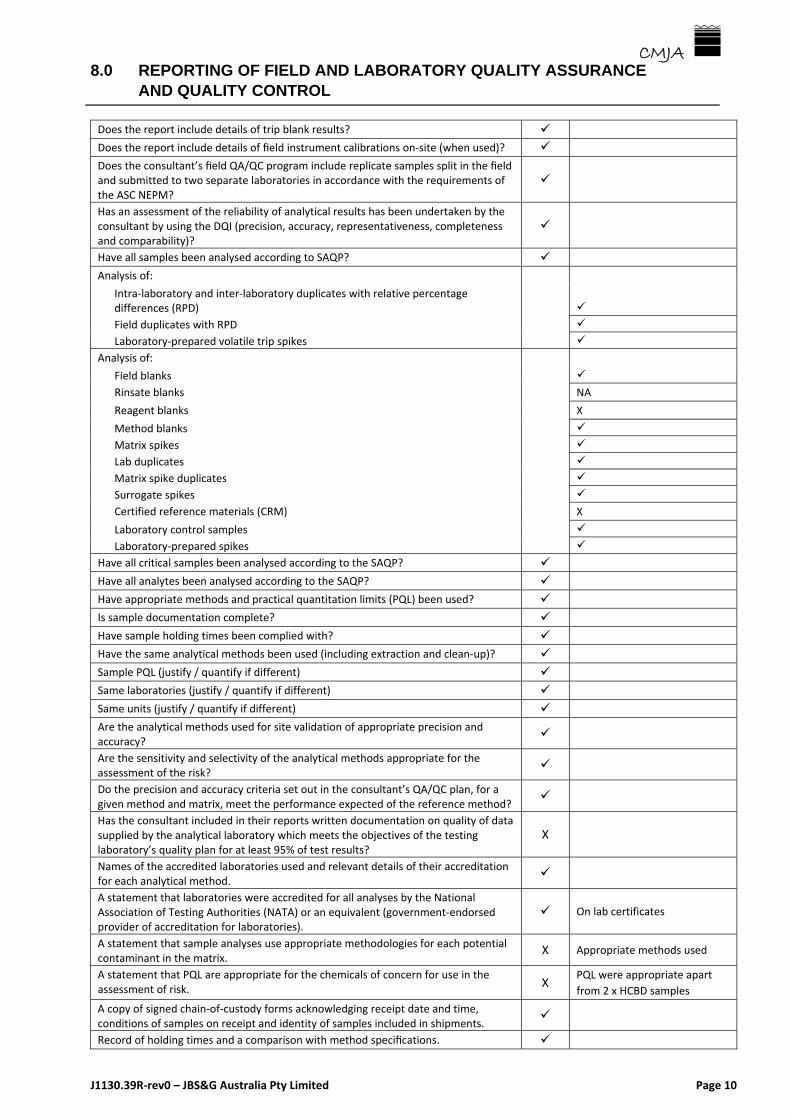
8.0 REPORTING OF FIELD AND LABORATORY QUALITY ASSURANCE AND QUALITY CONTROL
J1130.39R‐rev0 – JBS&G Australia Pty Limited Page 10
CMJA
Does the report include details of trip blank results?
Does the report include details of field instrument calibrations on‐site (when used)?
Does the consultant’s field QA/QC program include replicate samples split in the field and submitted to two separate laboratories in accordance with the requirements of the ASC NEPM?
Has an assessment of the reliability of analytical results has been undertaken by the consultant by using the DQI (precision, accuracy, representativeness, completeness and comparability)?
Have all samples been analysed according to SAQP?
Analysis of:
Intra‐laboratory and inter‐laboratory duplicates with relative percentage differences (RPD)
Field duplicates with RPD
Laboratory‐prepared volatile trip spikes
Analysis of:
Field blanks
Rinsate blanks NA
Reagent blanks X
Method blanks
Matrix spikes
Lab duplicates
Matrix spike duplicates
Surrogate spikes
Certified reference materials (CRM) X
Laboratory control samples
Laboratory‐prepared spikes
Have all critical samples been analysed according to the SAQP?
Have all analytes been analysed according to the SAQP?
Have appropriate methods and practical quantitation limits (PQL) been used?
Is sample documentation complete?
Have sample holding times been complied with?
Have the same analytical methods been used (including extraction and clean‐up)?
Sample PQL (justify / quantify if different)
Same laboratories (justify / quantify if different)
Same units (justify / quantify if different)
Are the analytical methods used for site validation of appropriate precision and accuracy?
Are the sensitivity and selectivity of the analytical methods appropriate for the assessment of the risk?
Do the precision and accuracy criteria set out in the consultant’s QA/QC plan, for a given method and matrix, meet the performance expected of the reference method?
Has the consultant included in their reports written documentation on quality of data supplied by the analytical laboratory which meets the objectives of the testing laboratory’s quality plan for at least 95% of test results?
X
Names of the accredited laboratories used and relevant details of their accreditation for each analytical method.
A statement that laboratories were accredited for all analyses by the National Association of Testing Authorities (NATA) or an equivalent (government‐endorsed provider of accreditation for laboratories).
On lab certificates
A statement that sample analyses use appropriate methodologies for each potential contaminant in the matrix.
X Appropriate methods used
A statement that PQL are appropriate for the chemicals of concern for use in the assessment of risk.
X PQL were appropriate apart
from 2 x HCBD samples
A copy of signed chain‐of‐custody forms acknowledging receipt date and time, conditions of samples on receipt and identity of samples included in shipments.
Record of holding times and a comparison with method specifications.

8.0 REPORTING OF FIELD AND LABORATORY QUALITY ASSURANCE AND QUALITY CONTROL
J1130.39R‐rev0 – JBS&G Australia Pty Limited Page 11
CMJA
Analytical methods used.
Laboratory accreditation for analytical methods used.
Laboratory performance in inter‐laboratory trials for the analytical methods used, where available.
X
Acceptance limit(s) for each QC test, such as duplicate RPD and recoveries for laboratory quality control analyses.
Where used, the origin of CRM, its batch number and the concentrations of the chemicals of potential concern.
X
Results for blind duplicate samples collected from the field.
Description of surrogates and spikes used
Per cent recoveries of spikes and surrogates
Instrument detection limit X
Method detection limits X
Matrix or practical quantification limits
Standard solution results X
CRM sample results X
Daily check sample results X
Laboratory (method) blank results
Laboratory standard charts X
The laboratory specifying compliance with the requirements of the ASC NEPM and equivalence with the reference method or non‐standard methods.
Does the consultant’s site assessment report address all QA/QC checklist items in the Guidelines for Consultants Reporting on Contaminated Sites (EPA 1997) related to field quality assurance and quality control, laboratory QA/QC and data evaluation QA/QC reporting?
Effective compliance
QC results relevant to the sample analysis.
For each sample, the highest measurement result wherever replicate measurements are taken (or all measurement results for each sample).
Results for all data tabulated separately according to each type of soil, fill materials, groundwater, surface water and sediments, with appropriate statistical analysis according to ASC NEPM requirements.
Is a QA/QC narrative that substantially complies with EPA (2017) and (1997) guidelines included in the report?

9.0 AUDITOR’S REVIEW OF FIELD AND LABORATORY QUALITY ASSURANCE AND QUALITY CONTROL
J1130.39R‐rev0 – JBS&G Australia Pty Limited Page 12
CMJA
Adequacy
Is the QA/QC information, as outlined above, provided by the consultant, adequate for the purpose of this audit? If no, provide comments as appropriate.
Adequacy of Fieldwork and Methods
In addition to the QA/QC information provided by the consultant, are the QA/QC samples obtained by the consultant and their associated laboratory results, adequate for the purpose of this audit? If no, provide comments as appropriate.
Adequacy of Laboratory
In addition to the QA/QC information provided by the consultant, are the laboratory QA/QC procedures sufficient to ensure that the laboratory results are adequate for the purpose of this audit? If no, provide comments as appropriate.
Data Usability
In summary, are the field and laboratory analytical data provided of adequate quality for the purpose of this audit? Comment further as necessary.
____________________________ 14/04/2019
Auditor Date
Yes No
Yes No
Yes No
Yes No

Site Audit Checklist
J1130.39R‐rev0 – JBS&G Australia Pty Limited Page 13
CMJA
Yes No
Yes No
Yes No
Yes No
ARE THE ASSESSMENT CRITERIA APPROPRIATELY PRESENTED?
The reviewer should note the following:
Comments
Assessment criteria tabulated
Assessment criteria discussed
Assessment criteria appropriate
Assessment criteria appropriately referenced
Limitation of criteria stated and discussed
Has the consultant evaluated land use suitability?
The reviewer should note the following:
Has the consultant followed the decision process for assessing urban
redevelopment sites (pp.45‐46 of the Auditor guidelines) when assessing the
suitability for a particular land use?
Not applicable
Are the Soil Investigation Levels (SIL) appropriate:
The reviewer should note the following:
Has the consultant used HIL?
Have HIL been used appropriately and competently by the consultant?
If HIL have not been used, has the consultant undertaken a site‐specific risk
assessment?
Undertaken by others on behalf of
client
Has the consultant used ESLs/EILs? X Not applicable
Has site‐specific bioavailability or ecotoxicity testing been carried out? X Not applicable
Are limitations of ecotoxicity testing addressed? X Not applicable
If relevant, with regard to petroleum hydrocarbons:
Has the consultant used ASC NEPM criteria?
Does the laboratory analysis support the use of ASC NEPM criteria?
Are the results adequately presented?
The reviewer should note the following:
Summary of previous work X Table only
Borehole/testpit logs correctly referenced X Table ‐ not logs
On‐site test results described in text
On‐site test results in appendix
Cross‐check between text and appendix
All laboratory results in appendix
Exceedances discussed in text
Exceedances shown on plan
Appropriate and correct discussion of hydrogeology
Comparison of analytical results with criteria
Assessment of contaminant transport and fate X
Discussion of human health risk implications X Separate HHRA
Discussion of ecological risk implications X
Yes No
Yes No

Site Audit Checklist
J1130.39R‐rev0 – JBS&G Australia Pty Limited Page 14
CMJA
Yes No
Yes No
RISK ASSESSMENT
General
Has a specific risk assessment been undertaken?
If so, has the consultant provided suitable justification for undertaking the risk
assessment? By others
Does the risk assessment satisfy all the Requirements in the Human Health Risk
Assessment Checklist? (Appendix A of the Guidelines). By others
Is the site‐specific risk assessment scientifically valid and do the recommended
site‐specific criteria protect the public health and the environment? By others
OTHER ENVIRONMENTAL IMPACTS, INCLUDING AESTHETIC ISSUES AND SEDIMENT QUALITY
Has the consultant addressed, where appropriate,
the potential for degradation of surface water and/or groundwater X
the potential for contaminant impacts on building structures X
aesthetic issues (including any odours and/or any discolouration of soil
arising from contamination)
sediment contamination and, where relevant, addressed the issues
contained in the Sediment Quality Guidelines (ANZECC 2000) X
OFF‐SITE MIGRATION OF CONTAMINANTS
Has the consultant adequately addressed all potential (or actual) issues arising
from off‐site migration of contaminants? Separate report
Does off‐site migration need to be addressed to protect human health or the
environment? X
Where appropriate, has the site owner or occupier been advised of the off‐site
migration risk by the consultant?
Where appropriate, has the site owner or occupier been advised of the off‐site
migration risk by the Auditor?
REMEDIAL ACTION
Remediation Policy and Issues Applicable?
Do remediation strategies or remediation actions have regard for the provisions
of appropriate national and state remediation policies?
Has the ASC NEPM preferred order of options for site remediation been
adopted?
Is the completed or proposed remediation technically and environmentally
justifiable?
Where vertical mixing of low‐level contaminated surface soils with cleaner soils
at depth has been undertaken and is outside the scope of the EPA’s Vertical
Mixing Guideline document, has this strategy been discussed with the EPA?
Where appropriate, has the consultant taken into consideration the provisions
of the Waste Legislation (POEO Act 1997, POEO (Waste) Regulation 2014) and
Planning Legislation (EPA Act 1979), and supporting regulation and guidelines?
Have appropriate controls been applied to the Handling, storage, treatment
and/or disposal of any wastes?
Where appropriate, has the consultant taken into consideration chemical wastes
that are subject to a Chemical Control Order (CCO), and where applicable, does
the management strategy comply with the requirements for the relevant CCO?
Have appropriate risk assessment procedures been applied to any
contamination left at depth?

Site Audit Checklist
J1130.39R‐rev0 – JBS&G Australia Pty Limited Page 15
CMJA
Yes No
Yes No
Yes No
Yes No
Capping and Containing Applicable?
Where cap and containment has been used or is proposed, is this appropriate
for the contaminants of concern?
Does it maximise the long‐term engineering security of the works?
Where applicable, minimize the potential for leachate formation and/or
volatilization?
Exclude the erection of structures on the capped or contained areas that may
result in risk of harm to the public health or the environment?
Include a notification mechanism to ensure that the capped or contained areas
are protected from any unintentional or uncontrolled disturbance that could
breach the integrity of the physical barrier?
Bioremediation Applicable?
Has consideration been given to the use of local species before foreign
organisms are/were introduced for bioremediation purposes?
Where imported organisms have been introduced for bioremediation purposes,
has the consultant:
obtained appropriate documentation for any species that has been imported
from overseas (relating to Australian Quarantine Inspection Services permit),
including any conditions accompanying the permit?
obtained a certificate from a recognized laboratory, identifying the species to
be released?
identified any potential risks to human health and animal health risks?
demonstrated appropriate knowledge of distribution of the organisms in
Australia and the dispersal mechanisms in air, water and soil?
assessed the expected survival period of the organisms in the environment and
possible consequences of the release?
documented the estimated number of organisms to be released and
frequency of release?
monitored the survival of the organisms to be released and frequency of
release?
put in place contingency measures to remove or destroy the organisms if a
hazard becomes evident?
Consent, Licence, Notification and Other Requirements Applicable?
Has the consultant identified any consents, licences, notifications or other
regulatory requirements relating to the site, and if so, have they been
appropriately addressed in site reports?
Have the requirements of SEPP55 been complied with?
Waste Management Applicable?
Were materials removed from the site appropriately classified for waste
disposal?
Has disposal documentation been sighted and checked?
Were waste materials transported to an appropriately licenced waste facility or
other legally permissible destination?
Do waste tonnages correspond to site volumes within reasonable error?

Site Audit Checklist
J1130.39R‐rev0 – JBS&G Australia Pty Limited Page 16
CMJA
Yes No
Yes No
Asbestos Applicable?
Has asbestos waste been appropriately managed?
Have asbestos clearance certificates been sighted?
Groundwater Clean‐Up and Management Applicable?
Have all primary and secondary sources of contamination been addressed?
Have the impacts of residual dissolved‐phase contamination been adequately
assessed?
Is any proposed use of monitored natural attenuation (MNA) appropriate?
Overview
Is the remediation appropriate for the site?
Has the remediation been satisfactorily completed and validated?
CONCLUSIONS AND RECOMMENDATIONS
Are findings summarised?
Are findings supported by data?
Are findings appropriate?
Are assumptions stated?
Are uncertainties/limitations stated?
Is a statement of constraints included?
Are recommendations for further work appropriate?
AUDITOR’S ASSESSMENT
Are the reports, as amended and clarified by the Consultant, adequate for the
purposes of this audit?
Is the site suitable for the intended use?
Is a site management plan required?
Is notification of groundwater contamination (including advice to the client,
notation on the site audit statement and discussion with EPA) required?
____________________________ 14/04/2019
Auditor Date

APPENDIX D2
Auditor’s Review of the Human Health Risk Assessment

Human Health Risk Assessment Checklist
Southland Block 1 HHRA Revision: Development of Flood Detention Basin ‐ 24 January 2019 Page 1
CMJA The Guidelines for the NSW Site Auditor Scheme (3rd edition, October 2017) state that the following checklist must be used by an auditor to review any human health risk assessments undertaken by a consultant. Where the auditor’s check reveals that the consultant’s risk assessment has omitted one or more of the points specified in the checklist, the auditor must document this in the site audit report and take this into account in reaching their site audit conclusions.
Title of Report: Southlands Block 1 HHRA Revision: Development of Flood Detention Basin
Report Number: 24 January 2019
Item
C = Compliance
P = Partial Compliance
N = Non‐compliance
NA = Not Applicable
Comments
Hazard Identification
Have all appropriate sources of information regarding chemicals of potential concern been identified and assessed?
C
Section 4 ‐ Identification of Risk Issues
Has justification been given for the selection of the chemicals of potential concern?
C
Toxicological Information
Have the critical toxic effects been identified?C
This report is an addendum to a series of previous HHRA for the Orica site. It utilises screening criteria derived from a number of identified and referenced sources. Previous HHRA have considered toxicology in more detail. Sources are recognised and appropriately used.
Have the effects on each body system (for example renal, hepatic, cardiovascular and developmental) and the types of effects (for example genotoxic and carcinogenic) been summarised?
C
Has the dose‐response relationship for chemicals of potential concern been discussed?
C
Have all relevant toxicological data been considered and checked for accuracy?
C
Has the adequacy of the available toxicological database been commented on?
C
Have relevant primary toxicological resources been considered?
C
Have different toxicity data from different resources been assessed and discussed?
C
Have the selected toxicity data been adequately justified?
C
Exposure Assessment
Has a comprehensive and appropriate conceptual site model been presented that indicates all potential pathways and receptors?
P Not in this report but present and relevant in cross‐referenced reports.
Have all potential receptors been identified? P On site issues in this report, off‐site addressed in separate report.
Have the estimated or measured exposure concentrations for each exposure route and chemical of potential concern been quantified?
C Source concentration in vapour measured. Exposure point concentrations estimated using attenuation factors.

Human Health Risk Assessment Checklist
Southland Block 1 HHRA Revision: Development of Flood Detention Basin ‐ 24 January 2019 Page 2
CMJA
Item
C = Compliance
P = Partial Compliance
N = Non‐compliance
NA = Not Applicable
Comments
Risk Characterisation
Has the acceptable risk level been identified and justified?
C
Non‐threshold criteria of 1x10‐5 and threshold Hazard Index of 1.0 identified and considered appropriate and consistent with usual Australian practice.
Have all potential receptors and pathways been considered?
C
Has the relative significance of each exposure pathway, based on the risk analysis, been discussed?
C
Has a sensitivity / uncertainty analysis been presented?
N
Equations
Have all equations used in the risk assessment been presented in the report?
NA
Screening criteria only used
Are all equations consistent? NA
Have all parameters and values in each equation been clearly defined?
NA
Have the correct units been allocated to each parameter?
NA
Are all equations dimensionally correct? NA
Have all unit conversion factors, where applicable, been included in the equations?
NA
Has all pertinent information been provided to enable calculations to be checked through in a step‐wise process?
NA
Data Evaluation
Have the data collection objectives been stated and are they consistent with the requirements of the risk assessment?
P
In investigation report
Have the laboratories that did the chemical analyses been noted, and do they have NATA accreditation (or equivalent) to perform each particular chemical analysis?
P
Has laboratory quality assurance / quality control (QA/QC) been reported and analysed?
P
Has field QA/QC been reported and analysed? P
Have statements of the accuracy of the laboratory data for each contaminant been made and have these been considered in the risk assessment?
N
Assessment and Report Presentation
Has information been presented coherently and in an appropriate sequence to enable efficient appraisal of the report?
CAuditor considers that these issues clearly and adequately explained.

Human Health Risk Assessment Checklist
Southland Block 1 HHRA Revision: Development of Flood Detention Basin ‐ 24 January 2019 Page 3
CMJA
Item
C = Compliance
P = Partial Compliance
N = Non‐compliance
NA = Not Applicable
Comments
Have the objectives and scope been clearly stated?
C
Auditor considers that these issues clearly and adequately explained.
Has information from previous reports on the site been appropriately selected and incorporated into this report?
C
Has the analysis been based on up‐to‐date literature?
C
Have all assumptions and data been identified and justified?
C
Have all tables and figures been referred to correctly in the text of the report?
C
Have adequate data been presented to support the conclusions?
C