simbolos petroleros
DESCRIPTION
simbolos industrialesTRANSCRIPT

Petroleum Style - ColorsGravity Main
Force Main/Purge Line/Stub Out
Distribution Main
Transmission Main
Alternate Main
Service Line
Fire Service
Siphon/Service Lateral
Undetermined Source
O2 Release Line
Hazardous Waste
Well Blue
Well Green
Well Red
Well Black
Waste Red
Copyright © 1999 - 2004 ESRI.All Rights Reserved.
Located in: ArcGIS\Bin\Styles\Petroleum.styleVersion: ArcGIS 9.0 1

Petroleum Style - Fill SymbolsGravity Main
Force Main/Purge Line/Stub Out
Distribution Main
Transmission Main
Alternate Main
Service Line
Fire Service
Siphon/Service Lateral
Undetermined Source
O2 Release Line
Well Blue
Well Green
Well Red
Well Black
Copyright © 1999 - 2004 ESRI.All Rights Reserved.
Located in: ArcGIS\Bin\Styles\Petroleum.styleVersion: ArcGIS 9.0 2

Petroleum Style - Line SymbolsGravity Main
Force Main
Distribution Main
Transmission Main
Alternate Main
Service Line
Fire Service
Siphon
Stub Out
Undetermined Source
O2 Release Line
Purge Line
Service Lateral
Copyright © 1999 - 2004 ESRI.All Rights Reserved.
Located in: ArcGIS\Bin\Styles\Petroleum.styleVersion: ArcGIS 9.0 3

Petroleum Style - Marker Symbols" Drill hole
ª Dry hole
³ Dry hole converted to water well
´ Dry hole converted to injection well
µ Show of oil
' Oil well
· Shut-in oil well
9 Abandoned oil well
( Abandoned oil wel - converted to water well
¶ Abandoned oil well - converted to injection
) Capped oil well
+ Show of gas
* Gas well
¸ Shut-in gas well
, Abandoned gas well
Copyright © 1999 - 2004 ESRI.All Rights Reserved.
Located in: ArcGIS\Bin\Styles\Petroleum.styleVersion: ArcGIS 9.0 4

Petroleum Style - Marker Symbols- Abandoned gas well - converted to water
. Abandoned gas well - converted to injection
/ Capped gas well
0 Show of oil and gas
1 Oil and gas well
¹ Shut-in oil and gas well
2 Abandoned oil and gas well
4 Capped oil and gas well
3 Abandoned well - converted to water well
5 Capped oil and gas well
6 Abandoned well - converted to water well
7 Abandoned well - converted to injection well
8 Saltwater-disposal well
R Water-injection well
º Water-input well
Copyright © 1999 - 2004 ESRI.All Rights Reserved.
Located in: ArcGIS\Bin\Styles\Petroleum.styleVersion: ArcGIS 9.0 5

Petroleum Style - Marker Symbolsz Hazardous-waste site
r Hazardous-waste site shows SL flow direction
à Hazardous-waste site CU Activities Completed
¦ Inactive (closed) hazardous - waste site
Ú Hazardous-waste site - CU activities in progress
Ù Active (operating) hazardous-waste site
S Dry hole converted to water well
T Injection Well, Abandoned 1
U Injection Well, Abandoned 2
V Injection Well, Abandoned 3
Y Well Production Suspended
\ D & AB
d Bottom Hole, Plugged & Abandoned
e Converted Injection Well, Abandoned
i D & AG
Copyright © 1999 - 2004 ESRI.All Rights Reserved.
Located in: ArcGIS\Bin\Styles\Petroleum.styleVersion: ArcGIS 9.0 6

Petroleum Style - Marker Symbols³ Dry Hole, 2
´ Dry hole converted to injection well, 2
Í Well, Shut-In
Î Gas Well, Abandoned
Ï ABDG
Ð Well, Abandoned Location
» Well, Abandoned for Content
« Well, Abandoned for Technical Reasons
[ Well, Abandoned and Plugged
a Well, Show of Gas
X Well, Significant Show of Gas
N Abandoned Location
$ Well, Temporarily Suspended 1
P Abandoned, Shut-In
! Proposed Well Location Tight
Copyright © 1999 - 2004 ESRI.All Rights Reserved.
Located in: ArcGIS\Bin\Styles\Petroleum.styleVersion: ArcGIS 9.0 7

Petroleum Style - Marker Symbols® Well, Temporarily Suspended 2
¯ Water Well, 1
° Water Well, 2
p Well Point
± Well, Temporarily Suspended 3
Z Abandoned Oil & Condensate Well
^ Oil & Condensate Well
_ Oil & Distillate Well, Dry
` Distillate Well, Show of Gas
b Gas & Condensate Well 1
f Distillate Well, Injection
g Gas & Condensate Well 2
h DO & G
k D & AO
O & G
Copyright © 1999 - 2004 ESRI.All Rights Reserved.
Located in: ArcGIS\Bin\Styles\Petroleum.styleVersion: ArcGIS 9.0 8

Petroleum Style - Marker Symbols1 Oil & Gas Producer
c Shut-In, Suspended or Idle Producing Oil &Gas
] Oil & Gas, 1
K Oil & Gas, 2
L Oil & Gas, 3
M Oil Well, Plugged & Abandoned
j Show of Oil
l Oil Well, Junked
© Oil Well, Junked & Abandoned
¬ Oil Well, Gas Show 1
¨ Oil Well, Gas Show 2
m Well, dual pipe
c LPG Well
d LPG Well, Label
e Pipeline Join 1
Copyright © 1999 - 2004 ESRI.All Rights Reserved.
Located in: ArcGIS\Bin\Styles\Petroleum.styleVersion: ArcGIS 9.0 9

Petroleum Style - Marker Symbolsf Pipeline Join 2
g Pipeline Join 3
h Pipeline Join 4
i Oil Droplet
j Oil Droplet, Half Filled
e Drill hole for mineral exploration
À Inclined adit, tunnel entry
Á Inclined adit, Inaccessible
 Portal
» Vertical Mine Shaft
½ Vertical Mine Shaft, Abandoned
¿ Inclined Mine Shaft
¾ Inclined Mine Shaft, Abandoned
à Prospect (pit or small open cut)
Ä Sand, gravel, clay, or placer pit
Copyright © 1999 - 2004 ESRI.All Rights Reserved.
Located in: ArcGIS\Bin\Styles\Petroleum.styleVersion: ArcGIS 9.0 10

Petroleum Style - Marker SymbolsÅ Sand, gravel, clay, or placer pit, Abandoned
Æ Open pit, quarry or glory hole
Ç Open pit, quarry or glory hole, Abandoned
¸ Raise or winze extending through level
¼ Inclined Mine Shaft-Above and below level
· Raise or foot of winze
º Winze or head of raise
¡ x1
t x2
8 x3
¸ x4
x x5
7 x6
¢ x7
£ x8
Copyright © 1999 - 2004 ESRI.All Rights Reserved.
Located in: ArcGIS\Bin\Styles\Petroleum.styleVersion: ArcGIS 9.0 11

Petroleum Style - Marker Symbols¤ x9
¥ x10
¦ x11
§ x12
¨ x13
© x14
# x15
* x16
+ x17
, x18
- x19
. x20
/ x21
Æ x22
F x23
Copyright © 1999 - 2004 ESRI.All Rights Reserved.
Located in: ArcGIS\Bin\Styles\Petroleum.styleVersion: ArcGIS 9.0 12
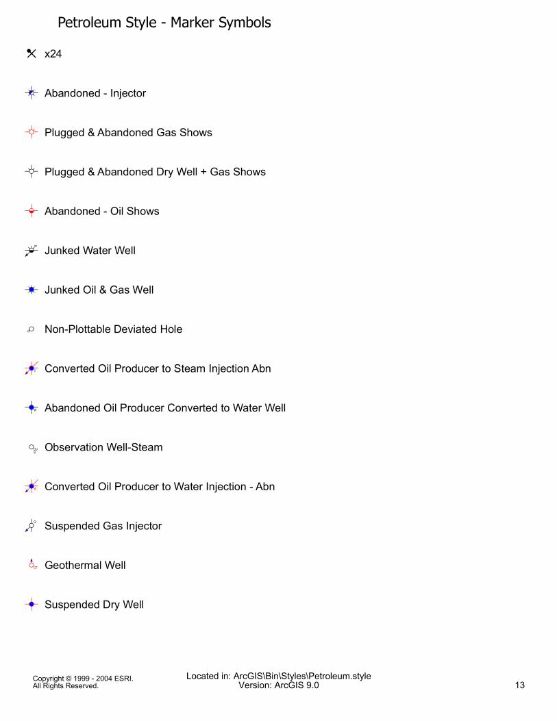
Petroleum Style - Marker SymbolsG x24
!# Abandoned - Injector
$ Plugged & Abandoned Gas Shows
$ Plugged & Abandoned Dry Well + Gas Shows
% Abandoned - Oil Shows
&' Junked Water Well
() Junked Oil & Gas Well
* Non-Plottable Deviated Hole
+, Converted Oil Producer to Steam Injection Abn
-) Abandoned Oil Producer Converted to Water Well
. Observation Well-Steam
/, Converted Oil Producer to Water Injection - Abn
01 Suspended Gas Injector
23 Geothermal Well
B) Suspended Dry Well
Copyright © 1999 - 2004 ESRI.All Rights Reserved.
Located in: ArcGIS\Bin\Styles\Petroleum.styleVersion: ArcGIS 9.0 13

Petroleum Style - Marker Symbols41 Gas Injection Well
51 Air Injection Well
61 Steam Injection Well
Ü1 Shut-In, Suspended or Idle Injection Well
8 Producing Non-Hydrocarbon Materials, Gases
9 Steam Well
: Junked or Junked and Abandoned
! Abandoned Gas Well
< Core Hole Location
= Proposed Well Location
= Unknown
> Core Hole or Core Test
= Potash Well
È) Oil & Gas Producer
= Combination Oil & Abandoned
Copyright © 1999 - 2004 ESRI.All Rights Reserved.
Located in: ArcGIS\Bin\Styles\Petroleum.styleVersion: ArcGIS 9.0 14

Petroleum Style - Marker Symbols= Gas Lift
9 Steam Geothermal
= Geopressure Well
= C02 Producer
@ Abandoned - Gas Injector
ÍA Plugged & Abandoned Gas Well + Oil Shows
øA Plugged & Abandoned Dry Well + Oil Shows
B) Plugged & Abandoned Well
Ï, Junked Water Injector + Oil & Gas Shows
ù, Junked Gas Well + Oil Shows
F1 Converted Water Disposal to Fire Flood Inj.- A
6, Converted Oil Producer to Steam Injection
J Abandoned Gas Storage Well
K Observation Well Salt Water
L, Converted Oil Producer to Water Disposal - Abnd
Copyright © 1999 - 2004 ESRI.All Rights Reserved.
Located in: ArcGIS\Bin\Styles\Petroleum.styleVersion: ArcGIS 9.0 15

Petroleum Style - Marker SymbolsM1 Suspended Water Well
c) Suspended Oil & Gas Well
N1 Abandoned Propane Injection Well
O1 Abandoned Fire Flood Injection Well
P1 Abandoned Water Injection Well
Q Suspended
R1 Shut-In, Suspended or Idle Water Disposal Well
S Shut-In Suspended or Idle Water Well
UV Proposed Location
!# Abandoned Gas and Condensate Well
È Producing Gas Well
B Abandoned-Dry Hole
= New Pool Wildcat
= Shallower Pool Test
= Suspended Well
Copyright © 1999 - 2004 ESRI.All Rights Reserved.
Located in: ArcGIS\Bin\Styles\Petroleum.styleVersion: ArcGIS 9.0 16

Petroleum Style - Marker Symbols= Oil Shale
= Oil & Gas Shows
= Salt Well
= Water Injection & Supply Well
= Hazardous Waste Disposal - Nuclear
X1 Combination Gas & Injection
= Coal
ú# Plugged & Abandoned Water Well
! Plugged & Abandoned Gas Well
B Plugged & Abandoned Dry Well
Z' Junked Gas Injector + Oil & Gas Shows
[1 Junked Water Injector + Gas Shows
( Junked Gas Well
O, Converted Oil Producer to Fire Flood Injection
,̂ Converted Oil Producer to Water Disposal
Copyright © 1999 - 2004 ESRI.All Rights Reserved.
Located in: ArcGIS\Bin\Styles\Petroleum.styleVersion: ArcGIS 9.0 17
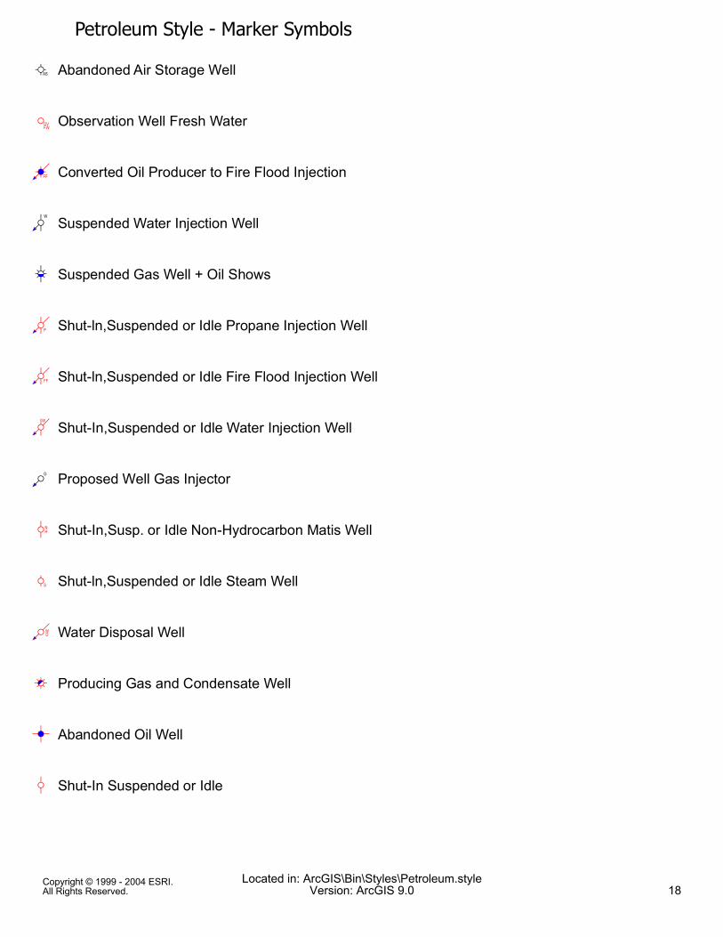
Petroleum Style - Marker Symbols_ Abandoned Air Storage Well
` Observation Well Fresh Water
a, Converted Oil Producer to Fire Flood Injection
b1 Suspended Water Injection Well
cE Suspended Gas Well + Oil Shows
e1 Shut-ln,Suspended or Idle Propane Injection Well
f1 Shut-ln,Suspended or Idle Fire Flood Injection Well
g1 Shut-In,Suspended or Idle Water Injection Well
h1 Proposed Well Gas Injector
i Shut-In,Susp. or Idle Non-Hydrocarbon Matis Well
j Shut-ln,Suspended or Idle Steam Well
k1 Water Disposal Well
È# Producing Gas and Condensate Well
B) Abandoned Oil Well
Q Shut-In Suspended or Idle
Copyright © 1999 - 2004 ESRI.All Rights Reserved.
Located in: ArcGIS\Bin\Styles\Petroleum.styleVersion: ArcGIS 9.0 18

Petroleum Style - Marker Symbolsm1 Water Injector
= Tight Well
n Stratigraphic Test
= Combination Oil & Service
= Oil Shows
) Multiple Oil Producer
= Combination Injection & Service
= Helium Well
= Gas Shows
= CO2 Injector
o Abandoned - Water Injector
$) Plugged & Abandoned Oil Well + Gas Shows
q Plugged & Abandoned Tight Well
r1 Junked Gas Injector + Gas Shows
Ï, Junked Water Injector + Oil Shows
Copyright © 1999 - 2004 ESRI.All Rights Reserved.
Located in: ArcGIS\Bin\Styles\Petroleum.styleVersion: ArcGIS 9.0 19
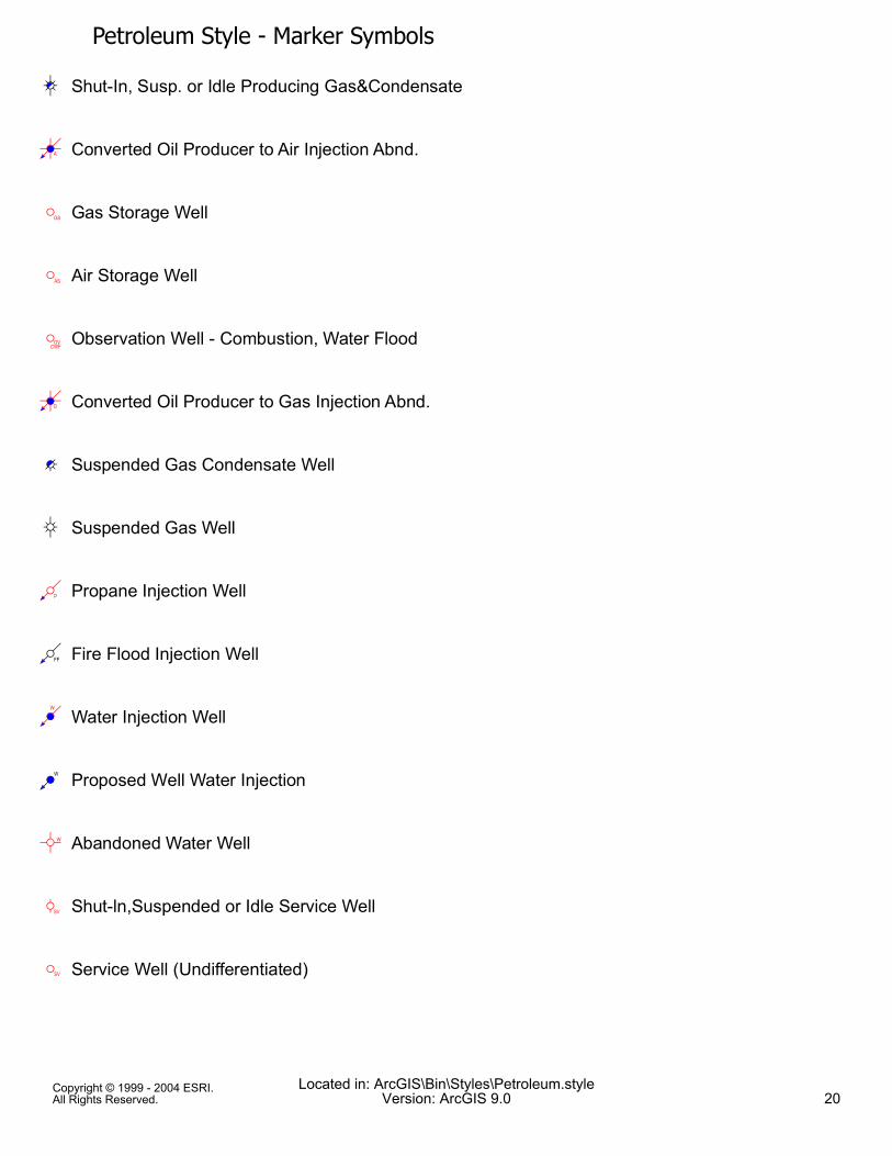
Petroleum Style - Marker Symbolsc# Shut-In, Susp. or Idle Producing Gas&Condensate
u, Converted Oil Producer to Air Injection Abnd.
v Gas Storage Well
w Air Storage Well
x Observation Well - Combustion, Water Flood
y, Converted Oil Producer to Gas Injection Abnd.
Ì# Suspended Gas Condensate Well
c Suspended Gas Well
¡1 Propane Injection Well
¢1 Fire Flood Injection Well
£, Water Injection Well
¤, Proposed Well Water Injection
¥ Abandoned Water Well
¦ Shut-ln,Suspended or Idle Service Well
§ Service Well (Undifferentiated)
Copyright © 1999 - 2004 ESRI.All Rights Reserved.
Located in: ArcGIS\Bin\Styles\Petroleum.styleVersion: ArcGIS 9.0 20

Petroleum Style - Marker Symbols)̈ Abandoned Oil and Gas Well
Q) Shut-In, Suspended or Idle Oil Well
= Surface Location
= New Field Wildcat
= Temperature Gradient
© Service Well or Unclassified
= Combination Oil & Observation
= Combination Oil & Dry Hole
ª Multiple Oil & Gas Producer
= lodine Well
= Hot Dry Rock
ü# Gas & Condensate Well
> Awaiting Testing
) Oil Producer
ú# Plugged & Abandoned Gas Condensate Well
Copyright © 1999 - 2004 ESRI.All Rights Reserved.
Located in: ArcGIS\Bin\Styles\Petroleum.styleVersion: ArcGIS 9.0 21

Petroleum Style - Marker SymbolsB) Plugged & Abandoned Oil Well
1 Abandoned - Oil & Gas Shows
ý' Junked Gas Injector + Oil Shows
¬1 Junked Water Injector
)̈ Shut-In, Suspended or Idle Producing Oil & Gas
5, Converted Oil Producer to Air Injection
¬, Converted Oil Producer to Water Injection
Abandoned Non-Hydrocarbon Materials Well
¯ Abandoned Observation Well (UNDIF)
¯ Junked - Unspecified
°± Abandoned Geothermal Well
²) Suspended Oil Well & Gas
³1 Abandoned Gas Injection Well
u1 Abandoned Air Injection Well
+1 Abandoned Steam Injection Well
Copyright © 1999 - 2004 ESRI.All Rights Reserved.
Located in: ArcGIS\Bin\Styles\Petroleum.styleVersion: ArcGIS 9.0 22

Petroleum Style - Marker Symbolsþ1 Abandoned Injection Well
· Abandoned Steam Well
n Abandoned Struct. or Strat. Test
1̧ Injection Well (Undifferentiated)
È) Producing Oil and Gas Well
=) Producing Oil Well
B) Proposed Oil Well Location
Ú1 Water Disposal
= Outpost or Extension Test
= Steam Injection
) Oil Producer
È) Oil, Gas & Condensate
È Multiple Gas Producer
1̧ Injection Well
È Gas Producer
Copyright © 1999 - 2004 ESRI.All Rights Reserved.
Located in: ArcGIS\Bin\Styles\Petroleum.styleVersion: ArcGIS 9.0 23

Petroleum Style - Marker Symbols= Development Well
¹ Platform Well
B) Completed Well
#) Plugged & Abandoned Oil & Gas Well
ÿA Plugged & Abandoned Dry Well + Oil & Gas Shows
$ Abandoned - Gas Shows
º' Junked Gas Injector
»# Junked Gas Condensate Well
½ Observation Well (Undifferentiated)
¾1 Converted Oil Producer to Gas Injection
J) Abandoned Oil Producer Converted to Gas Storage
½ Observation Well - Temperature
å Shut-In,Suspended or Idle Observation Well
¾1 Suspended - Injector
°± Shut-ln,Suspended or Idle Geothermal Well
Copyright © 1999 - 2004 ESRI.All Rights Reserved.
Located in: ArcGIS\Bin\Styles\Petroleum.styleVersion: ArcGIS 9.0 24

Petroleum Style - Marker SymbolsQ) Suspended Oil Well
;1 Shut-In,Suspended or Idle Gas Injection Well
G1 Shut-ln,Suspended or Idle Air Injection Well
\1 Shut-in,Suspended or Idle Steam Injection Well
¿1 Abandoned Water Disposal Well
À Abandoned Service Well
Á Abandoned Core Hole
 Water Well
c Shut-In, Suspended or Idle Gas Well
à Structure or Stratigraphic Test Location
Ä Proposed Well Location Tight
= Uranium
= Deeper Pool Test
= Gas Storage Well
,̧ Oil Injection Well
Copyright © 1999 - 2004 ESRI.All Rights Reserved.
Located in: ArcGIS\Bin\Styles\Petroleum.styleVersion: ArcGIS 9.0 25

Petroleum Style - Marker Symbols= Observation Well
= Oil (Gas Lift)
= Hazardous Waste Disposal - Nonnuclear
= Combination Gas & Service
B Dry Hole
 Water Well
= Bottom hole Injector Well
)̧ Bottom hole Injector After Oil Production
!E Bottom hole Plugged & Abandoned Gas Producer
;1 Bottom hole Suspended Gas Injector
! Bottom hole Suspended Gas Producer
B) Bottom hole Suspended Dry Well
s' Bottom hole Completed Gas Injector + Oil Show
£1 Bottom hole Completed Water Injector
Æ Bottom hole Completed Gas Well
Copyright © 1999 - 2004 ESRI.All Rights Reserved.
Located in: ArcGIS\Bin\Styles\Petroleum.styleVersion: ArcGIS 9.0 26
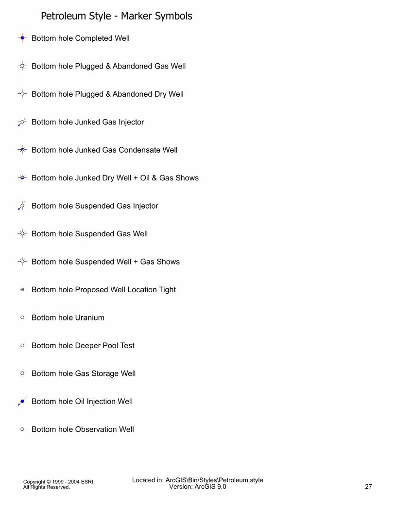
Petroleum Style - Marker SymbolsB) Bottom hole Completed Well
! Bottom hole Plugged & Abandoned Gas Well
B Bottom hole Plugged & Abandoned Dry Well
º1 Bottom hole Junked Gas Injector
ú# Bottom hole Junked Gas Condensate Well
ÇA Bottom hole Junked Dry Well + Oil & Gas Shows
¾1 Bottom hole Suspended Gas Injector
! Bottom hole Suspended Gas Well
$ Bottom hole Suspended Well + Gas Shows
Ä Bottom hole Proposed Well Location Tight
= Bottom hole Uranium
= Bottom hole Deeper Pool Test
= Bottom hole Gas Storage Well
,̧ Bottom hole Oil Injection Well
= Bottom hole Observation Well
Copyright © 1999 - 2004 ESRI.All Rights Reserved.
Located in: ArcGIS\Bin\Styles\Petroleum.styleVersion: ArcGIS 9.0 27

Petroleum Style - Marker Symbols= Bottom hole Oil (Gas Lift)
= Bottom hole Hazardous Waste Disposal - Nonnuclear
= Bottom hole Combination Gas & Service
B Bottom hole Dry Hole
 Bottom hole Water Well
X, Injector After Oil & Gas Production
P1 Plugged & Abandoned Injection Well
$) Plugged & Abandoned Oil Producer + Gas Shows
ú# Suspended Gas Condensate Producer
$E Suspended Oil Shows
B) Completed Tight Well
Ê, Completed Water Well
Ì# Completed Gas Condensate Well
Æ Completed Gas Well
) Oil Producer
Copyright © 1999 - 2004 ESRI.All Rights Reserved.
Located in: ArcGIS\Bin\Styles\Petroleum.styleVersion: ArcGIS 9.0 28

Petroleum Style - Marker SymbolsÎD Bottom hole Injector After Gas Condensate Producer
³1 Bottom hole Plugged & Abandoned Gas Injector
Æ Bottom hole Plugged & Abandoned Gas Producer
g1 Bottom hole Suspended Water Injector
$E Bottom hole Suspended Oil & Gas Shows
= Bottom hole Producer Well
41 Bottom hole Completed Gas Injector
Ì# Bottom hole Completed Gas Condensate Well
=) Bottom hole Completed Oil & Service Well
"# Bottom hole Plugged & Abandoned Water Well
$) Bottom hole Plugged & Abandoned Oil Well + Gas
q Bottom hole Plugged & Abandoned Tight Well
Ï' Bottom hole Junked Water Well
() Bottom hole Junked Oil & Gas Well
è Bottom hole Junked Dry Well + Gas Shows
Copyright © 1999 - 2004 ESRI.All Rights Reserved.
Located in: ArcGIS\Bin\Styles\Petroleum.styleVersion: ArcGIS 9.0 29

Petroleum Style - Marker SymbolsM1 Bottom hole Suspended Water Well
$) Bottom hole Suspended Oil Well & Gas
lE Bottom hole Suspended Well + Oil Shows
= Bottom hole Proposed Well Location
= Bottom hole Unknown
> Bottom hole Core Hole or Core Test
= Bottom hole Potash Well
È) Bottom hole Oil & Gas Producer
= Bottom hole Combination Oil & Abandoned
= Bottom hole Gas Lift
? Bottom hole Steam Geothermal
= Bottom hole Geopressure Well
= Bottom hole C02 Producer
q Bottom hole Well
X' Injector After Gas Production + Oil Shows
Copyright © 1999 - 2004 ESRI.All Rights Reserved.
Located in: ArcGIS\Bin\Styles\Petroleum.styleVersion: ArcGIS 9.0 30

Petroleum Style - Marker SymbolsP1 Plugged & Abandoned Water Injector
B) Plugged & Abandoned Oil Producer
!) Suspended Oil & Gas Producer
$) Suspended Oil Producer + Gas Shows
B) Completed Observation Well
Ê' Completed Water Injector + Oil & Gas Shows
È) Completed Multiple Oil & Gas Well
=) Completed Oil & Service Well
B) Completed Well
X) Bottom hole Injector After Oil & Gas Production
P1 Bottom hole Plugged & Abandoned Injection Well
$) Bottom hole Plugged & Abandoned Oil Producer
Ì# Bottom hole Suspended Gas Condensate Producer
ËA Bottom hole Suspended Oil Shows
B) Bottom hole Completed Tight Well
Copyright © 1999 - 2004 ESRI.All Rights Reserved.
Located in: ArcGIS\Bin\Styles\Petroleum.styleVersion: ArcGIS 9.0 31
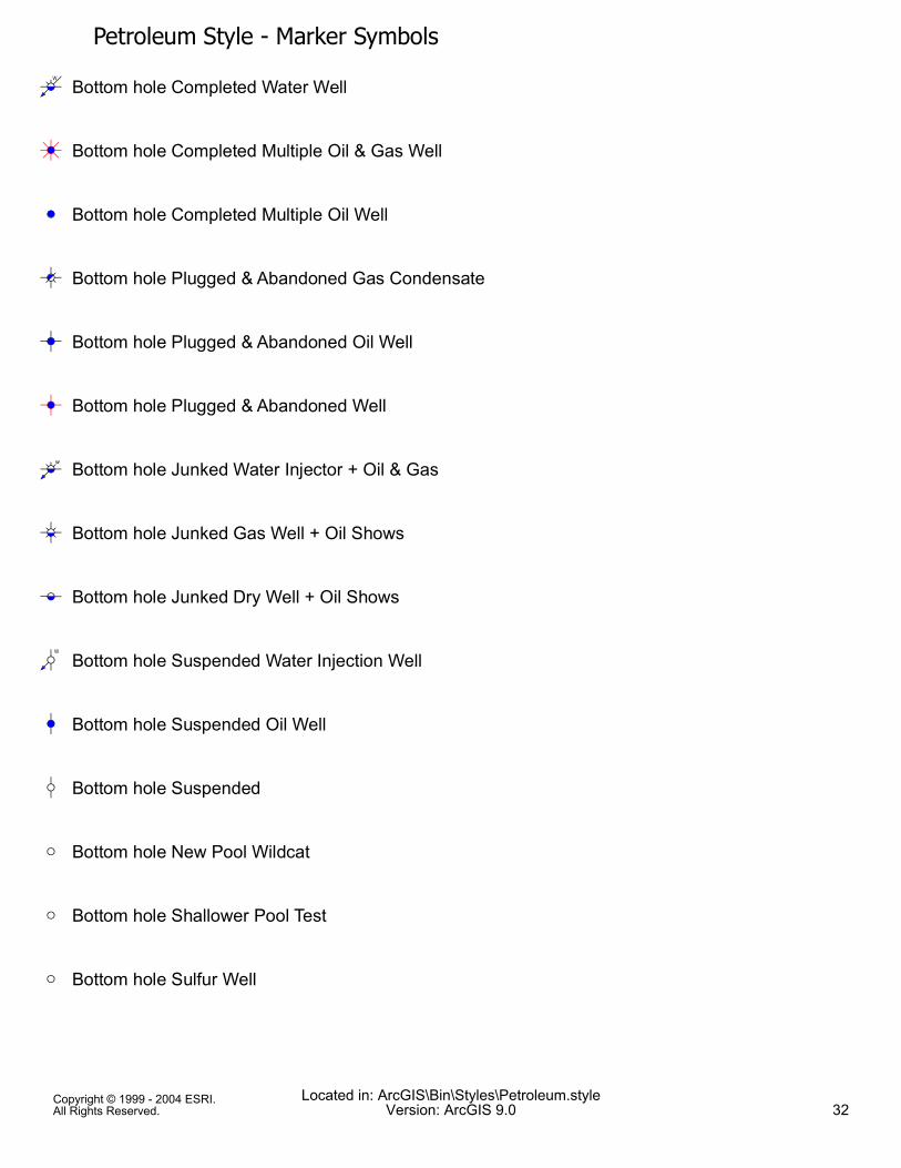
Petroleum Style - Marker SymbolsÊ' Bottom hole Completed Water Well
Æ) Bottom hole Completed Multiple Oil & Gas Well
=) Bottom hole Completed Multiple Oil Well
I# Bottom hole Plugged & Abandoned Gas Condensate
B) Bottom hole Plugged & Abandoned Oil Well
B) Bottom hole Plugged & Abandoned Well
[' Bottom hole Junked Water Injector + Oil & Gas
ùE Bottom hole Junked Gas Well + Oil Shows
ÔE Bottom hole Junked Dry Well + Oil Shows
M1 Bottom hole Suspended Water Injection Well
Q) Bottom hole Suspended Oil Well
Q Bottom hole Suspended
= Bottom hole New Pool Wildcat
= Bottom hole Shallower Pool Test
= Bottom hole Sulfur Well
Copyright © 1999 - 2004 ESRI.All Rights Reserved.
Located in: ArcGIS\Bin\Styles\Petroleum.styleVersion: ArcGIS 9.0 32

Petroleum Style - Marker Symbols= Bottom hole Oil Shale
= Bottom hole Oil & Gas Shows
= Bottom hole Salt Well
= Bottom hole Water Injection & Supply Well
= Bottom hole Hazardous Waste Disposal - Nuclear
X1 Bottom hole Combination Gas & Injection
= Bottom hole Coal
) Well Input from Pl
X' Injector After Gas Production
ü# Plugged & Abandoned Gas Condensate Producer
B) Suspended Unknown Well
ÿE Suspended Gas Shows
Q) Suspended Oil Producer
Z' Completed Gas Injector + Oil & Gas Shows
É1 Completed Water Injector + Gas Shows
Copyright © 1999 - 2004 ESRI.All Rights Reserved.
Located in: ArcGIS\Bin\Styles\Petroleum.styleVersion: ArcGIS 9.0 33

Petroleum Style - Marker SymbolsÆ) Completed Oil & Gas Well
=) Completed Multiple Oil Well
I# Abandoned - Injector
X' Bottom hole Injector After Gas Production + Oil
P1 Bottom hole Plugged & Abandoned Water Injector
B) Bottom hole Plugged & Abandoned Oil Producer
È) Bottom hole Suspended Oil & Gas Producer
$) Bottom hole Suspended Oil Producer + Gas Shows
B) Bottom hole Completed Observation Well
Ê' Bottom hole Completed Water Injector + Oil & Gas Shows
È) Bottom hole Completed Oil & Gas Well
=) Bottom hole Completed Oil Well
() Bottom hole Plugged & Abandoned Oil & Gas Well
ÿE Bottom hole Plugged & Abandoned Dry Well + Oil
Z' Bottom hole Junked Gas Injector + Oil & Gas Shows
Copyright © 1999 - 2004 ESRI.All Rights Reserved.
Located in: ArcGIS\Bin\Styles\Petroleum.styleVersion: ArcGIS 9.0 34

Petroleum Style - Marker Symbols&1 Bottom hole Junked Water Injector + Gas Shows
( Bottom hole Junked Gas Well
Õ Bottom hole Junked Dry Well
ú# Bottom hole Suspended Gas Condensate Well
B) Bottom hole Suspended Dry Well
h1 Bottom hole Proposed Well Gas Injector
X1 Bottom hole Water Injector
= Bottom hole Tight Well
n Bottom hole Stratigraphic Test
= Bottom hole Combination Oil & Service
= Bottom hole Oil Shows
=) Bottom hole Multiple Oil Producer
) Bottom hole Combination Injection & Service
) Bottom hole Helium Well
) Bottom hole Gas Shows
Copyright © 1999 - 2004 ESRI.All Rights Reserved.
Located in: ArcGIS\Bin\Styles\Petroleum.styleVersion: ArcGIS 9.0 35

Petroleum Style - Marker Symbols) Bottom hole CO2 Injector
Ñ Observation - Unspecified
Ò) Injector After Oil Production + Gas Shows
!) Plugged & Abandoned Oil & Gas Producer
B) Suspended Observation Well
Í) Suspended Gas Producer + Oil Shows
B) Suspended Tight Well
Ó1 Completed Gas Injector + Gas Shows
Y, Completed Water Injector + Oil Shows
ÍE Completed Gas Well + Oil Shows
=) Completed Oil Well
@ Abandoned - Gas Injector
ú1 Bottom hole Injector After Gas Production
ú# Bottom hole Plugged & Abandoned Gas Condensate
B) Bottom hole Suspended Unknown Well
Copyright © 1999 - 2004 ESRI.All Rights Reserved.
Located in: ArcGIS\Bin\Styles\Petroleum.styleVersion: ArcGIS 9.0 36

Petroleum Style - Marker SymbolsBottom hole Suspended Gas Shows
Bottom hole Suspended Oil Producer
Bottom hole Completed Gas Injector + Oil & Gas
Bottom hole Completed Water Injector + Gas Shows
Bottom hole Completed Gas Well + Oil Shows
Bottom hole Completed Oil Well + Gas Shows
Bottom hole Plugged & Abandoned Gas Shows
Bottom hole Plugged & Abandoned Dry Well + Gas Shows
Bottom hole Junked Gas Injector + Gas Shows
Bottom hole Junked Water Injector + Oil Shows
Bottom hole Junked Oil Well + Gas Shows
Bottom hole Junked Tight Well
Bottom hole Suspended Oil & Gas Well
Bottom hole Suspended Tight Well
Bottom hole Proposed Well Water Injection
Copyright © 1999 - 2004 ESRI.All Rights Reserved.
Located in: ArcGIS\Bin\Styles\Petroleum.styleVersion: ArcGIS 9.0 37

Petroleum Style - Marker Symbols= Bottom hole New Field Wildcat
= Bottom hole Temperature Gradient
Ö Bottom hole Service Well or Unclassified
= Bottom hole Combination Oil & Observation
= Bottom hole Combination Oil & Dry Hole
È) Bottom hole Multiple Oil & Gas Producer
= Bottom hole lodine Well
= Bottom hole Hot Dry Rock
ü# Bottom hole Gas & Condensate Well
> Bottom hole Awaiting Testing
= Injector Well
)̧ Injector After Oil Production
ÍA Plugged & Abandoned Gas Producer + Oil Shows
01 Suspended Gas Injector
! Suspended Gas Producer
Copyright © 1999 - 2004 ESRI.All Rights Reserved.
Located in: ArcGIS\Bin\Styles\Petroleum.styleVersion: ArcGIS 9.0 38

Petroleum Style - Marker SymbolsB) Suspended Dry Well
s, Completed Gas Injector + Oil Shows
£1 Completed Water Injector
Æ Completed Multiple Gas Well
×) Completed Oil Well + Gas Shows
ú# Plugged & Abandoned Water Well
Ò) Bottom hole Injector After Oil Production + Gas
!) Bottom hole Plugged & Abandoned Oil & Gas Producer
B) Bottom hole Suspended Observation Well
ùE Bottom hole Suspended Gas Producer + Oil Shows
B) Bottom hole Suspended Tight Well
Ó1 Bottom hole Completed Gas Injector + Gas Shows
Y, Bottom hole Completed Water Injector + Oil Shows
Æ Bottom hole Completed Multiple Gas Well
=) Bottom hole Oil Producer
Copyright © 1999 - 2004 ESRI.All Rights Reserved.
Located in: ArcGIS\Bin\Styles\Petroleum.styleVersion: ArcGIS 9.0 39

Petroleum Style - Marker SymbolsùE Bottom hole Plugged & Abandoned Gas Well + Oil Shows
øE Bottom hole Plugged & Abandoned Dry Well + Oil Shows
Ù' Bottom hole Junked Gas Injector + Oil Shows
t1 Bottom hole Junked Water Injector
Õ) Bottom hole Junked Oil Well
=) Bottom hole Junked Well
ùE Bottom hole Suspended Gas Well + Oil Shows
ÿE Bottom hole Suspended Well + Oil & Gas Shows
B) Bottom hole Proposed Oil Well Location
Û1 Bottom hole Water Disposal
= Bottom hole Outpost or Extension Test
= Bottom hole Steam Injection
=) Bottom hole Oil Producer
È) Bottom hole Oil, Gas & Condensate
È Bottom hole Multiple Gas Producer
Copyright © 1999 - 2004 ESRI.All Rights Reserved.
Located in: ArcGIS\Bin\Styles\Petroleum.styleVersion: ArcGIS 9.0 40

Petroleum Style - Marker Symbols1̧ Bottom hole Injection Well
È Bottom hole Gas Producer
= Bottom hole DeveIopment Well
¹ Bottom hole Platform Well
ÎD Injector After Gas Condensate Production
³1 Plugged & Abandoned Gas Injector
! Plugged & Abandoned Gas Producer
g1 Suspended Water Injector
$E Suspended Oil & Gas Shows
= Producer Well
41 Completed Gas Injector
£1 Injector
{ Producer - Gas with Oil Shows
| Producer - Oil with Gas Shows
Copyright © 1999 - 2004 ESRI.All Rights Reserved.
Located in: ArcGIS\Bin\Styles\Petroleum.styleVersion: ArcGIS 9.0 41

' Petro North 1
Petroleum - North Arrows
( Petro North 2 ) Petro North 3
* Petro North 4 + Petro North 5 , Petro North 6
Copyright © 1999 - 2004 ESRI.All Rights Reserved.
Located in: ArcGIS\Bin\Styles\Petroleum.styleVersion: ArcGIS 9.0 42