silurian stratigraphy of central iran – an update
TRANSCRIPT
Title Silurian stratigraphy of Central Iran – an update
Authors Hairapetian, V; Pour, MG; Popov, LE; Männik, P; Miller, CG
Date Submitted 2018-01-08

Acta Geologica Polonica, Vol. 67 (2017), No. 2, pp. 201–233
DOI: 10.1515/agp-2017-0014
Silurian stratigraphy of Central Iran – an update
VACHIK HAIRAPETIAN1, MANSOUREH GHOBADI POUR2, 3, LEONID E. POPOV3, PEEP MÄNNIK4
and C. GILES MILLER5
1 Department of Geology, Isfahan (Khorasgan) Branch, Islamic Azad University,PO Box 81595−158, Isfahan, Iran. E-mail: [email protected]
2 Department of Geology, Faculty of Sciences, Golestan University, Gorgan, Iran.E-mail: [email protected]
3 Department of Geology, National Museum of Wales, Cardiff CF10 3NP, Wales, United Kingdom.E-mail: [email protected]
4 Institute of Geology at Tallinn University of Technology, Ehitajate tee 5, 19086 Tallinn, Estonia.E-mail: [email protected]
5 Department of Earth Science, Natural History Museum, London SW7 5BD, United Kingdom.E-mail: [email protected]
ABSTRACT:
Hairapetian, V., Ghobadi Pour, M., Popov, L.E., Männik, P. and Miller, C.G. 2017. Silurian stratigraphy of Central Iran – an update. Acta Geologica Polonica, 67 (2), 201−233. Warszawa.
The Silurian biostratigraphy, lithostratigraphy, and facies of Central Iran including the Kashmar (Boghu Mountains), Tabas (Derenjal Mountains, Ozbak-Kuh), Anarak (Pol-e Khavand) and Kerman regions is re-viewed and updated. The current state of knowledge of the Silurian in the Zagros Basin, Alborz, Kopet-Dagh and Talysh regions, as well as in a few areas scattered across the Sabzevar Zone, and the Sanandaj-Sirjan terranes is also reviewed. Silurian volcanism in various parts of Iran is briefly discussed. The end of the Ordovician coincided with a widespread regression across Iran synchronous with the Hirnantian glaciation, and only in the Zagros Basin is there a continuous Ordovician–Silurian transition represented by graptolitic black shales of the Sarchahan Formation. In the Central-East Iranian Platform marine sedimentation re-commenced in the early to mid Aeronian. By the Sheinwoodian, carbonate platform depositional environments were established along its north-eastern margin. In other parts of Iran (e.g., Kopet-Dagh and the Sabzevar Zone), siliciclastic sedimentation continued probably into the late Silurian. The Silurian conodont and brachiopod biostratigraphy of Central Iran is significantly updated facilitating a precise correlation with the Standard Global Chronostratigraphic Scale, as well as with key Silurian sections in other parts of Iran. The Silurian lithostratigraphy is considerably revised and two new lithostratigraphical units, namely the Boghu and Dahaneh-Kalut formations, are introduced.
Key words: I ran; Si lur ian; Biostrat igraphy; Li thostrat igraphy; Sedimentology; Correlat ion.
INTRODUCTION
The presence of Silurian deposits in Central Iran was established more than half a century ago (Flügel 1962; Huckriede et al. 1962). However, little progress had subsequently been made in Silurian re-search until the past decade, when a number of pub-
lications considerably increased our knowledge of Iranian Silurian litho- and biostratigraphy. This has significantly changed our general understanding of Silurian geology in Iran, whereas reviews published more than ten years ago have become increasingly outdated. The main objective of this paper is to out-line in detail the Silurian successions and associated

202 VACHIK HAIRAPETIAN ET AL.
faunas of the Central-East Iranian Platform, which is the major Silurian domain in Iran (Text-fig. 1). During the early Palaeozoic, this region is considered to have been situated within temperate latitudes on
the margins of the Gondwana Supercontinent (e.g., Golonka 2012; Torsvik and Cocks 2013). While its precise position in relation to the other Gondwana terranes cannot be defined with any degree of confi-
Text-fig. 1. Simplified tectonic maps of Iran showing the location of Silurian outcrops (marked with red colour; small exposures are exagger-ated) discussed in the paper (base map modified mainly from Ramezani and Tucker 2003 and Hairapetian et al. 2012); structural data compiled from various sources, e.g., Berberian and King (1981), Lindenberg et al. (1984) and Alavi (1991). Abbreviations: AZF – Abiz Fault; DRF – Doruneh Fault; KBF – Kuhbanan Fault; KMF – Kalmard Fault; MAF – Mehdiabad Fault; MZT – Main Zagros Thrust; NAF – Nostratabad Fault; NBF – Nayband Fault; NHF – Nehbandan Fault; NNF – Nain Fault; OKF – Ozbak Kuh Fault; RVF – Rivash Fault; SBF – Shahre-Babak
Fault; SHF – Syahkuh Fault; TKF – Taknar Fault

SILURIAN STRATIGRAPHY OF CENTRAL IRAN – AN UPDATE 203
dence at present, recently documented early Silurian faunas from Central Iran suggest closest links with Afghanistan and the north-east Iranian Kopet-Dagh Range (Hairapetian et al. 2012; Popov et al. 2014). In the south-west, the Central-East Iranian Platform is bounded by the Sanandaj-Sirjan terrane and the Main Zagros Thrust Zone. The existing Silurian record of the Sanandaj-Sirjan terrane is very poor with the only documented Silurian deposits within the region cropping out in the Jehagh Anticline and Sargerd Mountain Ranges, in the vicinity of Soh village (Text-fig. 1). Silurian deposits are widespread along the north-eastern margin of the Arabian Platform on the opposite side of the Main Zagros Thrust Zone, where they are represented mainly by black grap-tolitic shales assigned to the Sarchahan Formation of Iran (Ghavidel-Syooki et al. 2011a). These black shales can be found in the subsurface through the Zagros Mountains and are the major hydrocarbon source rock for the Dalan and Kangan reservoirs (Saberi et al. 2016). The Silurian sedimentology and biostratigraphy of the Zagros Basin has been outlined in some detail by Ghavidel-Syooki et al. (2011a) and Saberi et al. (2016). The Alborz Mountains are often considered part of Central Iran in a broad sense, but most probably represent an isolated microplate in the early Palaeozoic (Popov et al. 2016). Here the Silurian is represented by volcanic rocks of the Soltan-Maidan Formation.
The only other Silurian outcrops in Iran are in the Boz-Kuh area (Sabzevar Zone) and in the Talesh Range, west of Rasht (Text-fig. 1). While the presence of the Silurian rocks in these regions was established more than 40 years ago (Alavi-Naini 1972; Clark et al. 1975), present knowledge of their litho- and bio-stratigraphy remains very general and their tectonic position in relation to other early Palaeozoic terranes uncertain. They probably had no close relation to the Alborz Microplate.
The material illustrated and/or discussed below is deposited in the National Museum of Wales, Cardiff, UK (NMW), in the Department of Earth Science, Natural History Museum, London, UK (NHMUK PM X), and in the Department of Geology, Azad University, Esfahan, Iran (AEU).
PREVIOUS WORK
Although the presence of Silurian sedimentary rocks was reported well over half a century ago from several regions in Iran, very few details of lithofacies, stratigraphy and faunal distribution have been pub-
lished since then. The first reports of the Silurian de-posits from Iran were published by Flügel (1962), who documented their presence in the Ozbak-Kuh Region, and by Huckriede et al. (1962), who reported the pres-ence of fossiliferous limestones and dolomites in the vicinity of Shabdjereh, Deh-Ali and Yazdan-Abad to the north-west of Kerman. They considered these de-posits as Ordovician to Silurian based on occurrences of corals, brachiopods (including rhynchonellids and “Platystrophia”, probably Stegocornu), bryozoans and tentaculites.
The Palaeozoic geology of the Derenjal Moun-tains, including the Shirgesht area, north of Tabas (north-eastern Central Iran) was described in more de-tail by Ruttner et al. (1968). They defined the Silurian to Lower Devonian formations of the Gushkamar Group and considered the Niur Formation in the Derenjal Mountains as the lower unit of that group. They also provided comprehensive lists of brachio-pods and corals found in Silurian deposits across the region.
Probably the first assessment of the Silurian stratigraphy of Iran was given by Berry and Boucot (1972) in their Special Paper dedicated to the correla-tion of the Silurian rocks of SE Asia and the Near East. They gave a brief review of the Silurian strata of the Kerman Region, at Shirgesht (Tabas Region) and Kuh-e-Gahkum, north of Bandar-Abbas. Illustrations of some Silurian fossils from Iran, including bra-chiopods, which were mostly incorrectly identified, can be also found in Kalantari (1981). Nine Silurian brachiopod taxa originally derived from the Niur Formation of Shirgesht and from Kuh-e-Gahkum in the south-eastern Zagros Range were identified. Wolfart (1981) gave the first general review of the Silurian stratigraphy of Iran. He suggested that the Silurian sedimentary successions are restricted to the north-eastern, east-central and south-eastern parts of Iran bordered from the east by the Lut Block and by possible Silurian highs to the south and north-west. The review publication by Wensink (1991) outlined the general stratigraphy of the northern and central regions of Iran. All of these publications are sig-nificantly outdated and do not represent the current state of knowledge based on recent work by Iranian researchers.
The subdivision of the Silurian System into se-ries and stages in Iran remained problematical until recently and the boundaries of the major internation-ally recognised chronostratigraphic units were not established in the region due to a shortage of pre-cise and systematic palaeontological and biostrati-graphic studies. The most recent systematic review

204 VACHIK HAIRAPETIAN ET AL.
of the Silurian stratigraphy of Iran was published by Stocklin and Setudehnia (1991). They listed sev-eral brachiopods and corals from the Niur Formation exposed at Ozbak-Kuh and Shirgesht in the Tabas Region.
Hamedi et al. (1997) questioned previous prelim-inary fossil identifications used to show evidence of Silurian sedimentary units in Iran, suggesting that they were often out of date and not always reliable. The only exception was Cocks (1979a), who reported a rich silicified brachiopod fauna from the Kopet-Dagh Range (north-eastern Iran), and introduced the Qarabil Formation for the Silurian deposits exposed in the region. Wendt et al. (2002, 2005) briefly dis-cussed the facies patterns and the palaeogeography of the Silurian of Iran. However, the lithostratigraphic, lithofacies and palaeogeographic data they presented are now considered outdated.
In recent years, significant progress has been made in the study of the Silurian sedimentary se-quences of the Zagros Basin and Central Iran (Tabas and Kashmar regions) where abundant graptolites, ostracodes, rugose corals, palynomorphs (includ-ing acritarchs and chitinozoans) and sporadic fish remains were documented in a number of recent publications (for summary see Ghavidel-Syooki 2001; Hairapetian et al. 2008, 2011). The Silurian brachiopods and conodonts of Central Iran are cur-rently under extensive study and are partly published (Hairapetian et al. 2012; Männik et al. 2013, 2015; Popov and Cocks 2013; Popov et al. 2015a). These works have expanded our knowledge of the Silurian geology, stratigraphy and palaeontology of Central Iran and the Kopet-Dagh Region.
The lithostratigraphical subdivision of the Silurian system in Iran is very poorly constrained and requires revision. The Niur Formation defined by Ruttner et al. (1968) was the first formal lithostratigraphical unit introduced to cover the Silurian sedimentary rocks of Central Iran. Currently the term Niur Formation is applied to a wide range of Silurian sedimentary rocks cropping out all over Iran except for the Zagros Basin. The most extensive work has been done by the authors in the Tabas, Kashmar and Kerman regions, all within the Central-East Iranian Microplate, where the Silurian deposits are well exposed. However, the type section of the Niur Formation situated in the Ozbak-Kuh area in the vicinity of Niur village has not been restudied since the work of Ruttner et al. (1968) and a detailed description of the type section of the unit has not been produced. As a result and despite the extensive use of the formation name, the strati-graphic range and boundaries of the Niur Formation
in the type section remain formally undefined. Wendt et al. (2002, p. 131) pointed out that the Ozbak-Kuh area is highly tectonized and represents a mosaic of small slices and blocks so that it is impossible to observe the stratigraphical relationships between the lithostratigraphical units established here. It is difficult to use them for geological mapping and they need to be restudied and redefined. The type sec-tion of the Niur Formation at Ozbak-Kuh is consid-ered to be faulted in its lower part and is composed mainly of carbonates (Ruttner et al. 1968). However, contrary to the original description of the section in the Derenjal Mountains by Ruttner et al. (1968), the lower contact of the Niur Formation, i.e. its contact with the Lower to Middle Ordovician deposits of the Shirgesht Formation, is also faulted (Bruton et al. 2004; Ghobadi Pour et al. 2006).
The use of the term Niur Formation has become almost synonymous with the Silurian System in Iran, and this has made it difficult to apply to geological mapping (see also Wendt et al. 2002). We suggest that the easiest solution is to raise this lithostratigraphi-cal unit to the rank of group, which unites all docu-mented Silurian successions within the Tabas Block. However, such defined “Niur Group” becomes then a junior synonym of the Gushkamar Group, which was established earlier (by page priority) in Ruttner et al. (1968) and this should be formally applied.
OUTLINE OF REGIONAL STRATIGRAPHY
Kashmar Region
Extensive outcrops of Silurian deposits are known south and south-west of the town of Kashmar in north-eastern Central Iran. The best Silurian succes-sion in the whole area documented up to date is lo-cated on the southern slope of the Boghu Mountains, c. 25 km south-west of Kashmar (Text-fig. 1). It was first described in some detail by Ghavidel-Syooki (2003) who assigned acritarchs from the Silurian part of the succession to the local Acritarch Assemblage Zone 7, which is dated as Llandovery to Wenlock. A detailed stratigraphical column and faunal logs for the Silurian succession in the Boghu Mountains were later published by Hairapetian et al. (2012). The Silurian deposits assigned here to the Boghu Formation are underlain by the upper Katkoyeh Formation of Upper Ordovician siliciclastic rocks. There is controversy over the position of the base of the Silurian in the area. The lower part of the exposed section comprises green siltstone/shale beds intercalated with beds of
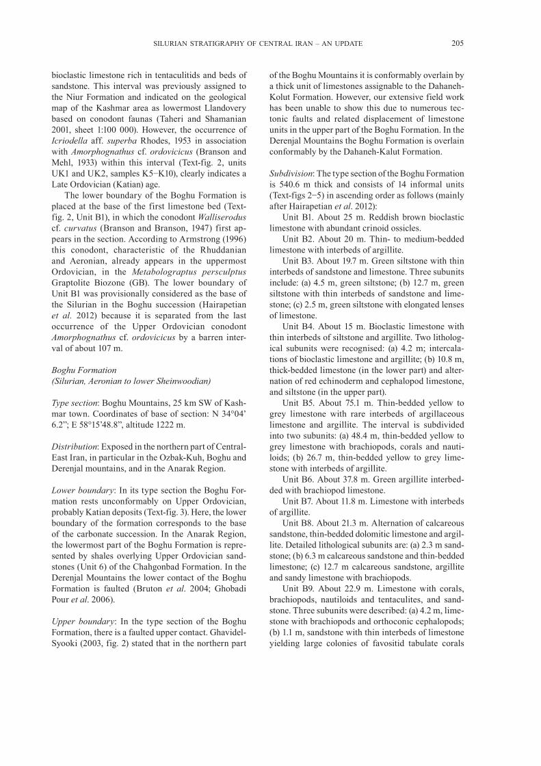
SILURIAN STRATIGRAPHY OF CENTRAL IRAN – AN UPDATE 205
bioclastic limestone rich in tentaculitids and beds of sandstone. This interval was previously assigned to the Niur Formation and indicated on the geological map of the Kashmar area as lowermost Llandovery based on conodont faunas (Taheri and Shamanian 2001, sheet 1:100 000). However, the occurrence of Icriodella aff. superba Rhodes, 1953 in association with Amorphognathus cf. ordovicicus (Branson and Mehl, 1933) within this interval (Text-fig. 2, units UK1 and UK2, samples K5−K10), clearly indicates a Late Ordovician (Katian) age.
The lower boundary of the Boghu Formation is placed at the base of the first limestone bed (Text-fig. 2, Unit B1), in which the conodont Walliserodus cf. curvatus (Branson and Branson, 1947) first ap-pears in the section. According to Armstrong (1996) this conodont, characteristic of the Rhuddanian and Aeronian, already appears in the uppermost Ordovician, in the Metabolograptus persculptus Graptolite Biozone (GB). The lower boundary of Unit B1 was provisionally considered as the base of the Silurian in the Boghu succession (Hairapetian et al. 2012) because it is separated from the last occurrence of the Upper Ordovician conodont Amorphognathus cf. ordovicicus by a barren inter-val of about 107 m.
Boghu Formation (Silurian, Aeronian to lower Sheinwoodian)
Type section: Boghu Mountains, 25 km SW of Kash-mar town. Coordinates of base of section: N 34°04’ 6.2”; E 58°15’48.8”, altitude 1222 m.
Distribution: Exposed in the northern part of Central-East Iran, in particular in the Ozbak-Kuh, Boghu and Derenjal mountains, and in the Anarak Region.
Lower boundary: In its type section the Boghu For-mation rests unconformably on Upper Ordovician, probably Katian deposits (Text-fig. 3). Here, the lower boundary of the formation corresponds to the base of the carbonate succession. In the Anarak Region, the lowermost part of the Boghu Formation is repre-sented by shales overlying Upper Ordovician sand-stones (Unit 6) of the Chahgonbad Formation. In the Derenjal Mountains the lower contact of the Boghu Formation is faulted (Bruton et al. 2004; Ghobadi Pour et al. 2006).
Upper boundary: In the type section of the Boghu Formation, there is a faulted upper contact. Ghavidel-Syooki (2003, fig. 2) stated that in the northern part
of the Boghu Mountains it is conformably overlain by a thick unit of limestones assignable to the Dahaneh-Kolut Formation. However, our extensive field work has been unable to show this due to numerous tec-tonic faults and related displacement of limestone units in the upper part of the Boghu Formation. In the Derenjal Mountains the Boghu Formation is overlain conformably by the Dahaneh-Kalut Formation.
Subdivision: The type section of the Boghu Formation is 540.6 m thick and consists of 14 informal units (Text-figs 2−5) in ascending order as follows (mainly after Hairapetian et al. 2012):
Unit B1. About 25 m. Reddish brown bioclastic limestone with abundant crinoid ossicles.
Unit B2. About 20 m. Thin- to medium-bedded limestone with interbeds of argillite.
Unit B3. About 19.7 m. Green siltstone with thin interbeds of sandstone and limestone. Three subunits include: (a) 4.5 m, green siltstone; (b) 12.7 m, green siltstone with thin interbeds of sandstone and lime-stone; (c) 2.5 m, green siltstone with elongated lenses of limestone.
Unit B4. About 15 m. Bioclastic limestone with thin interbeds of siltstone and argillite. Two litholog-ical subunits were recognised: (a) 4.2 m; intercala-tions of bioclastic limestone and argillite; (b) 10.8 m, thick-bedded limestone (in the lower part) and alter-nation of red echinoderm and cephalopod limestone, and siltstone (in the upper part).
Unit B5. About 75.1 m. Thin-bedded yellow to grey limestone with rare interbeds of argillaceous limestone and argillite. The interval is subdivided into two subunits: (a) 48.4 m, thin-bedded yellow to grey limestone with brachiopods, corals and nauti-loids; (b) 26.7 m, thin-bedded yellow to grey lime-stone with interbeds of argillite.
Unit B6. About 37.8 m. Green argillite interbed-ded with brachiopod limestone.
Unit B7. About 11.8 m. Limestone with interbeds of argillite.
Unit B8. About 21.3 m. Alternation of calcareous sandstone, thin-bedded dolomitic limestone and argil-lite. Detailed lithological subunits are: (a) 2.3 m sand-stone; (b) 6.3 m calcareous sandstone and thin-bedded limestone; (c) 12.7 m calcareous sandstone, argillite and sandy limestone with brachiopods.
Unit B9. About 22.9 m. Limestone with corals, brachiopods, nautiloids and tentaculites, and sand-stone. Three subunits were described: (a) 4.2 m, lime-stone with brachiopods and orthoconic cephalopods; (b) 1.1 m, sandstone with thin interbeds of limestone yielding large colonies of favositid tabulate corals

206 VACHIK HAIRAPETIAN ET AL.
Text-fig. 2. Boghu Mountains section. From left to right: formations; described units; lithological log (arrows below and above the log indicate that the section continues in both directions); locations and numbers of samples; distribution of taxa; conodont biozones (after Cramer et al. →

SILURIAN STRATIGRAPHY OF CENTRAL IRAN – AN UPDATE 207
Text-fig. 3. Field photographs of the Upper Ordovician and Silurian (Llandovery) exposures in the Boghu Mountains. A – Southwesterly view of the uppermost part of the outcrop showing the uppermost Ordovician–lowermost Silurian interval; B – Ordovician–Silurian boundary (= boundary between units UK9 and B1) and lower part of the Boghu Formation (units B1−B5); C – Close-up view of the Ordovician–Silurian
boundary (marked by a discontinuity surface between units UK9 and B1). Distinct facies change occurs at the system boundary
2011) and general stratigraphy (Stage, Series, System). Grey boxes in the column of conodont biozonation indicate biozones (or parts of) that were recognised in the studied section. Abbreviations: Pt. – Pterospathodus; a. – amorphognathoides; p. – pennatus; K. – Kockelella; Oz. –
Ozarkodina; s. – sagitta; o. – ortus; S.Z. – Superzone

208 VACHIK HAIRAPETIAN ET AL.
(up to 20 cm in diameter); (c) 17.6 m, limestone with large colonies of favositid tabulate corals, brachio-pods and tentaculites.
Unit B10. About 31.3 m. Alternation of sandstone, shale and limestone. Five subunits were identified: (a) 12.3 m, sandstone; (b) 2.5 m, bioclastic limestone
Text-fig. 4. Field photographs of the middle part of the Boghu Formation in the Boghu Mountains. A – Westerly view of the Boghu Formation, units B5–B9; B – Alternation of thin-bedded limestone and argillite in the lower part of Unit B5; C – Alternation of dark brown sandstone and greyish-green argillite in Unit B8; D-E – Large favositid tabulate corals (indicated with arrows) in units B9 (0.6 m above K24/3) and B11
(1.9 m below sample K27)

SILURIAN STRATIGRAPHY OF CENTRAL IRAN – AN UPDATE 209
with interbeds of argillite; (c) 3.4 m, brown sand-stone; (d) 11.9 m, sandy limestone with interbeds rich in brachiopods and of argillite; (e) 1.2 m, sandstone.
Unit B11. 131.7 m. Alternation of limestone and argillite with rare interbeds of sandstone. Nine sub-
units were recognised: (a) 10.25 m, limestone and ar-gillite with large colonies of favositid tabulate corals (up to 20 cm in diameter); (b) 12.2 m, limestone with brachiopods; (c) 0.9 m, sandstone; (d) 21 m, dolomitic limestone with brachiopods; (e) 27.1 m, argillite and
Text-fig. 5. Field photographs of the Boghu Formation in the Boghu Mountains. A – General view of units B10 and B11; B – Sandstones in Unit B12; C – Units B13 and B14. People for scale are c. 1.8 m tall

210 VACHIK HAIRAPETIAN ET AL.
limestone with brachiopods; (f) 33.5 m, dolomitic limestone and dolostone; (g) 23.1 m, bioclastic lime-stone and argillite; (h) 2.2 m, dolomitic limestone with brachiopods; (I) 1.5 m, bioclastic limestone.
Unit B12. About 61.8 m. Grey to white cross-bed-ded sandstone with interbeds of argillite and siltstone.
Unit B13. About 73.7 m. Alternation of shale and limestone with brachiopods and trilobites at some levels.
Unit B14. About 5.25 m. Sandy limestone and sandstone.
Biostratigraphy and age: The conodont Disto mo-dus staurognathoides (Walliser, 1964) in sample K21 and possibly also in K20 (Text-fig. 2, Unit B5; Text-fig. 6H) suggests that this level is not older than the Aeronian: in the Baltic Distomodus staurogna-thoides probably appears in the upper Demirastrites triangulatus GB but is definitely present in the Demirastrites simulans GB (Loydell et al. 2010). Aulacognathus antiquus Bischoff, 1986 in sample K21 (Text-figs 2 and 6I) indicates an even younger middle Aeronian age for the sample. In New South Wales, Australia, Aulacognathus antiquus occurs in the upper Aeronian Stimulograptus sedgwickii or lower Telychian Spirograptus turriculatus GBs (Bischoff 1986). However, graptolites of these bio-zones have not been recorded from the Quarry Creek Limestone, which yielded the conodonts and, thus, there is no evidence to support this biostratigraphic assignment. Recent data from Estonia demonstrates that Aulacognathus antiquus is already present in the Pribylograptus leptotheca GB (Männik et al. 2016). Hence, based on conodonts, sample K21 comes from a level not older than the middle Aeronian Pribylograptus leptotheca GB.
In sample K36 a single specimen of Arianagnathus (identified as A. cf. jafariani Männik, Miller and Hairapetian, 2015; Text-fig. 2, Unit B13; Text-fig. 6A) was found. Based on the data from the Derenjal Mountains (Männik et al. 2013, fig. 3; Text-fig. 7) beds with Arianagnathus jafariani correspond to the Pterospathodus celloni Conodont Superzone and are of middle Telychian age.
Distomodus staurognathoides ranges up to Unit B13. The uppermost specimen in the section comes from sample K37 (Text-figs 2 and 5), where it oc-curs with Kockelella ranuliformis (Walliser, 1964). In the next sample studied (K38) only Kockelella ranuliformis (Text-fig. 6K) was found. It is probable that both samples were collected from the boundary interval between the Lower and Upper Kockelella ranuliformis CBs, K37 just below and K38 just above it, and both are of early Sheinwoodian age.
The brachiopod fauna is represented by three succeeding low diversity rhynchonellide associa-tions (Hairapetian et al. 2012; Popov et al. 2015a), which occur in the middle to upper part of the Boghu Formation (Text-fig. 2; units B9−B13). The lower-most association is dominated by Stegocornu pro-cerum Dürkoop, 1970. This species first appears in Unit B9 (Text-fig. 2; sample K25), where it occurs with Clorinda sp. and Palaeoleptostrophia sp. [= Mesoleptostrophia (Mesoleptostrophia) sp. of Hair-apetian et al. 2012] and ranges up into Unit B11 (Text-fig. 2; sample K28), where it forms a mono-taxic association. Higher in that unit (samples K29, 30), Stegocornu procerum is replaced by Stegocornu denisae Popov, Modzalevskaya and Ghobadi Pour in Hairapetian et al., 2012. This replacement occurs in the upper part of the Distomodus staurognathoides CB. Stegocornu denisae has a very narrow strati-
Text-fig. 6. Selected conodonts from the Boghu and Derenjal sections. A – Arianagnathus cf. jafariani Männik, Miller and Hairapetian, 2015; sinistral Pa element, inner lateral (A1), upper (A2) and oblique lower (A3) views, Boghu section, sample K36, Boghu Formation, NHMUK PM X 3687; B – Arianagnathus jafariani Männik, Miller and Hairapetian, 2015; dextral Pa element, upper (B1) and inner lateral (B2) views, Derenjal section, sample S19, Dahaneh-Kalut Formation, NHMUK PM X 3603; C, D, F – Pterospathodus amorphognathoides lennarti Männik, 1998; C – sinsitral Pb1 element, outer lateral view, NHMUK PM X 3599; D – dextral Pb2 element, outer lateral view, NHMUK PM X 3597; F – dextral Pa element, upper view; all specimens from Derenjal section, sample S19, Dahaneh-Kalut Formation, NHMUK PM X 3598; E – Ozarkodina ex gr. snajdri (Walliser, 1964), dextral Pa element, lower (E1) and upper (E2) views, Derenjal section, sample S28, Dahaneh-Kalut Formation, NHMUK PM X 3268; G – Ozarkodina bohemica bohemica (Walliser, 1964), dextral(?) Pa element, lateral (G1) and lower (G2) views, Derenjal section, sample S24, Dahaneh-Kalut Formation, NHMUK PM X 3273; H – Distomodus staurognathoides (Walliser, 1964), dextral Pa element, upper view, Derenjal section, sample S12, Boghu Formation, NHMUK PM X 3275; I – Aulacognathus antiquus Bischoff, 1986, dextral Pa element, lateral (I1) and upper (I2) views, Boghu section, sample K21, Boghu Formation, NHMUK PM X 3615; J – Amorphognathus cf. ordovicicus (Branson and Mehl, 1933), dextral Pa element, upper view, Boghu section, sample K8, “upper Katkoyeh Formation”, NHMUK PM X 3688; K – Kockelella ranuliformis (Walliser, 1964), sinistral(?) Pa element, upper (K1) and lateral (K2) views, Boghu section, sample K38, Boghu Formation, NHMUK PM X 3622; L – Icriodella aff. superba Rhodes, 1953, sinsitral Pa element, outer lateral (L1) and upper (L2) views, Boghu section, sample K9, “upper Katkoyeh Formation”, NHMUK PM X 3606; M – Walliserodus cf. curva-tus (Branson and Branson, 1947), dyscritiform element, lateral view, Boghu section, sample K11/2, Boghu Formation, NHMUK PM X 3689; N – Ozarkodina derenjalensis Männik, Miller and Hairapetian, 2015, Pa element, lateral view, Boghu section, sample K25, Boghu Formation,
NHMUK PM X 3690. Scale bars represent 0.1 mm
→

SILURIAN STRATIGRAPHY OF CENTRAL IRAN – AN UPDATE 211

212 VACHIK HAIRAPETIAN ET AL.
Text-fig. 7. Dahaneh-Kalut section in the Derenjal Mountains. From left to right: formations; described units; lithological log (arrows below and above the log indicate that the section continues in both directions); locations and numbers of samples; distribution of taxa; conodont bio-zones (after Cramer et al. 2011) and general stratigraphy (Stage, Series, System). Grey boxes in the column of conodont biozonation indicate zones (or their parts) that were recognised in the studied section. Abbreviations: Pt. – Pterospathodus; a. – amorphognathoides; p. – pennatus; K. – Kockelella; Oz. – Ozarkodina; s. – sagitta; o. – ortus; v. – variabilis; Anc. – Ancoradella; Pol. – Polygnathoides; S.Z. – Superzone; I.Z.
– Interval Zone; Gorst. – Gorstian

SILURIAN STRATIGRAPHY OF CENTRAL IRAN – AN UPDATE 213
graphical range, which probably coincides with this conodont biozone (Text-fig. 2). We suggest that the occurrence of this brachiopod species in Iran is an important biostratigraphical marker showing a latest Aeronian age.
The third brachiopod association occurs in Unit B13 (Text-fig. 2; sample K33/1). It includes only the rhynchonellide Jafarirhynchus alatus Popov, Hairapetian, Ghobadi Pour and Modzalevskaya, 2015 as the dominant species and the spiriferide Striispirifer? ocissimus Popov, Modzalevskaya and Ghobadi Pour in Hairapetian et al., 2012. Based on the conodont distribution through the section, a Telychian age is suggested for this association.
Depositional environments and lithofacies: The Boghu Formation was deposited in a shallow shelf environment varying from shoreface zone to shallow offshore shelf, characteristic of Benthic Assemblage Zones (BA) 2−3 (after Boucot 1975). In the middle to upper part of the formation there is a prolifer-ation of rhynchonellide biofacies characterized by low to medium diversity rhynchonellide associa-tions dominated by Stegocornu (Text-fig. 8D) in the middle to upper Aeronian part of the succession and by Jafarirhynchus (Text-fig. 8B) in the Telychian (Hairapetian et al. 2012; Popov et al. 2015a). In the Derenjal Mountains the lower part of the Boghu Formation contains bioherms of tabulate corals.
Derenjal Mountains
The area is located in north-eastern Central Iran about 65 km north-west of Tabas (Text-fig. 1; see also Ruttner et al. 1968; Hairapetian et al. 2008). The Silurian deposits crop out relatively widely in the southern and eastern parts of the Derenjal Mountains, on the flanks of a large anticline. The best section in the area is situated c. 1.4 km east of the Dahaneh-Kalut valley and 8.3 km north-north-east from the Shirgesht railway station. The profile is composed of outcrops located across three major hills named A, B and C by Hairapetian et al. (2008).
The Silurian succession in the area was first doc-umented in detail by Ruttner et al. (1968). Later, the contact between the Ordovician and Silurian was found by Bruton et al. (2004) to be faulted. For a long time the rugose and tabulate corals, and stro-matoporoids described by Flügel (1969), Flügel and Saleh (1970) and Hubmann (1991) were the only Silurian fossils monographically documented from the area. Recently, rich Silurian faunas, including brachiopods, ostracodes and thelodont fishes, have
been discovered and published by Hairapetian et al. (2008, 2011, 2012) from the section. The distribution of Llandovery to Ludlow conodonts (Männik et al. 2013) indicates that the Derenjal Mountains show the most complete Silurian sedimentary succession so far documented in Iran. The Silurian deposits in the area were previously assigned entirely to the Niur Formation but are now subdivided in ascending order into the Boghu and Dahaneh-Kalut formations.
The Boghu Formation, the lower part of the Silurian succession in the Derenjal Mountains, is a heterolithic unit with a total thickness up to 286 m (Text-fig. 7). It comprises (in ascending order; Männik et al. 2013): (1) up to 12.8 m of olivine basalt; (2) up to 23.5 m of limestone, mainly of bioclas-tic packstone and grainstone; (3) 56.4 m of altered, dark green olivine basalt; (4) c. 43 m of siltstone intercalating with silty argillite; (5) c. 63 m of white, cross-laminated quartz arenite; (6) up to 6.7 m of brown thin-bedded sandy limestone; (7) up to 33.8 m of grey to brown, medium- to thin-bedded bioclastic packstone and grainstone with interbeds rich in bra-chiopod shells; (8) up to 14.2 m of white medium- to thin-bedded allochemic sandstone; (9) 7.8 m of brown limestone intercalating with dolomitic limestone; (10) up to 77.7 m of allochemic sandstone. In the described transect the Boghu Formation is overlain conformably by the Dahaneh-Kalut Formation.
The lowermost unit of the Boghu Formation in the Derenjal Mountains contains a few conodonts, notably Ozarkodina cf. hassi (Pollock, Rexroad and Nicoll, 1970), Walliserodus cf. curvatus, Wurmiella? sp. and Panderodus sp. identified by P. Männik. This assemblage of conodonts has a stratigraphic range from the lower Rhuddanian to the middle Aeronian. The occurrence of the brachiopods Stricklandia lens intermedia Williams, 1951 and Dicoelosia os-loensis Wright, 1968 (Text-fig. 7) also suggest an early Aeronian age. In Baltoscandia and Britain they have a stratigraphic range from the late Rhuddanian Coronograptus cyphus GB up to the mid Aeronian Lituigraptus convolutus GB (Wright 1968; Barlii 1986; Cocks 2008; Rubel 2011). The list of brachiopod genera from Unit B2 includes Coolinia, Dolerorthis, Eospirigerina, Isorthis, Leptaena, Meifodia, Strick-landia, Stegorhynchus, Palaeoleptostrophia, Prota-trypa and Triplesia. The occurrence of the acrotretide Opsiconidion aldridgei (Cocks, 1979b) is remarkable, because it is one of the earliest Silurian records of the Order Acrotretida (Text-fig. 8L). A Lazarus taxon is the craniopside Pseudopholidops (Text-fig. 8K). Previously, the last documented occurrence of this genus was in the Hirnantian (Popov et al. 2013).

214 VACHIK HAIRAPETIAN ET AL.
However, new data from Iran clearly demonstrate that it had survived into the Silurian. In spite of a sig-nificant number of newly evolved brachiopod genera, there is no sign of endemism in the fauna; many of them acquired almost global distribution in the late
Rhuddanian to Aeronian low latitude faunas (Popov et al. 2014; Rong and Cocks 2014). There is a signif-icant proportion of extinction survivors (Cocks and Rong 2008; Popov et al. 2014). Bioclasts in the rock are mainly fragments of tiny fenestrate bryozoans,
Text-fig. 8. Selected brachiopod taxa from the Silurian of the Boghu and Derenjal Mountains. A – Striispirifer? ocissimus Popov, Modzalevskaya and Ghobadi Pour in Hairapetian et al., 2012, NMW 2011.11G.359, ventral view of a pair of conjoined valves, sample K-30, Unit 30 in Text-fig. 2 (Hairapetian et al. 2012, fig. 11A); B – Jafarirhynchus alatus Popov, Hairapetian, Ghobadi Pour and Modzalevskaya, 2015, AEU1502, dorsal view of a pair of conjoined valves, sample K33/1, Unit B13 in Text-fig. 2 (Popov et al. 2015a, fig. 3C1); C – Clorinda sp., NMW 2011.11G.1, ventral view of a pair of conjoined valves, sample K25, Unit 18 in Text-fig. 2 (Hairapetian et al. 2012, fig. 6N); D – Stegocornu procerum Dürkoop, 1970, NMW 2011.11G.213, dorsal view of a pair of conjoined valves, sample K25, Unit 18 in Text-fig. 2 (Hairapetian et al., 2012, fig. 7D); E – Stegocornu denisae Popov, Modzalevskaya and Ghobadi Pour in Hairapetian et al., 2012, NMW 2011.11G.269, dorsal view of a pair of conjoined valves, sample S14, Unit 7 in Text-fig. 8 (Hairapetian et al. 2012, fig. 7J); F – Protathyris sp., AEU825, ventral view of a pair of conjoined valves, sample K28/29, Unit 20 in Text-fig. 8; G – Protathyris sp., AEU826, view on cardinalia of a pair of conjoned valves, sample K31+3 m, Unit 20 in Text-fig. 8; H – AEU827, cluster of two dorsal valves of Striispirifer sp. and one dorsal valve of Levenea sp. showing interiors, sample S31, Unit 20 in Text-fig. 8; I – Levenea sp., AEU827, dorsal valve interior, sample S31, Unit 20 in Text-fig. 8; J – Dicoelosia osloensis Wright, 1968, AEU828, dorsal valve interior, Unit 2 in Text-fig. 8; K – Pseudopholidops, AEU829, ventral valve exterior, Unit 2 in Text-fig. 8; L – Opsiconidion aldridgei (Cocks, 1979b), NHMUK PI BC 64277, ventral valve exterior, side view, Unit 2 in
Text-fig. 8. Scale bars represent 2 mm except where indicated
SILURIAN STRATIGRAPHY OF CENTRAL IRAN – AN UPDATE 215
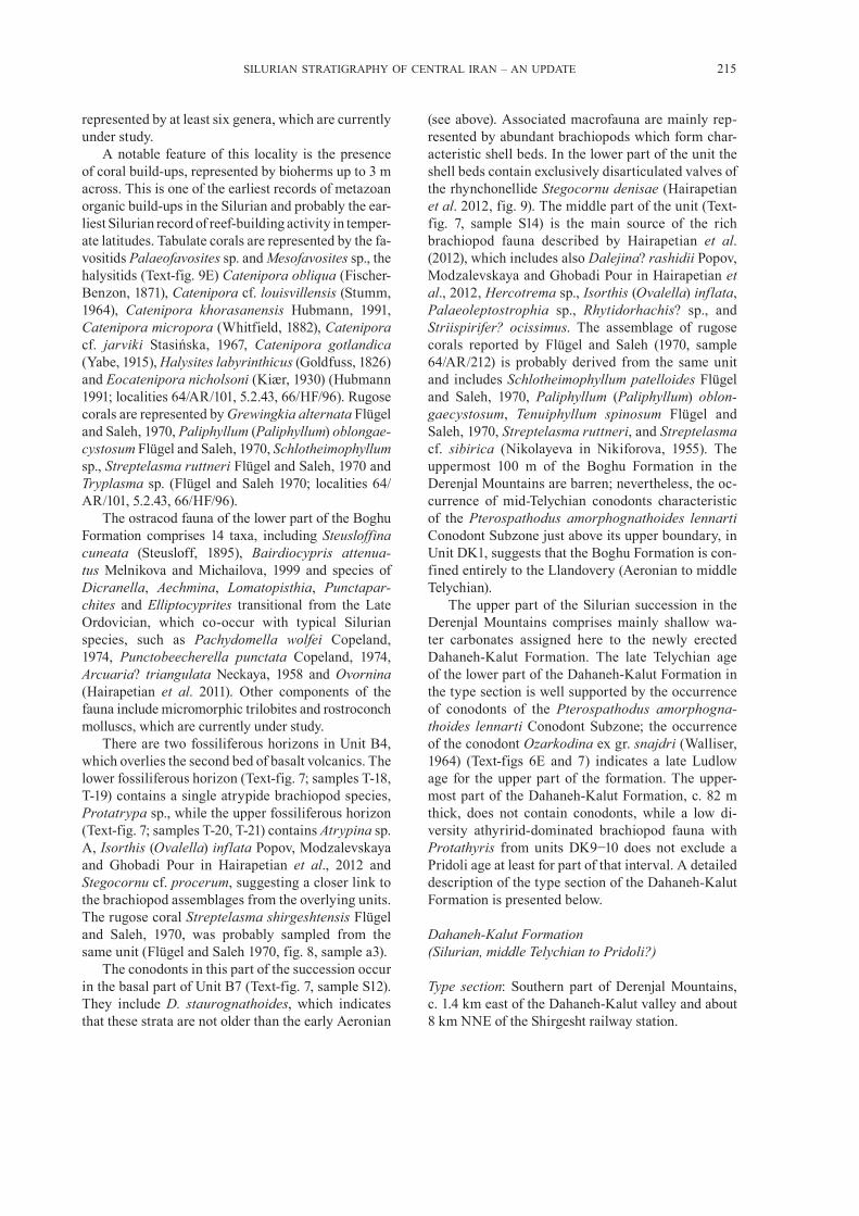
represented by at least six genera, which are currently under study.
A notable feature of this locality is the presence of coral build-ups, represented by bioherms up to 3 m across. This is one of the earliest records of metazoan organic build-ups in the Silurian and probably the ear-liest Silurian record of reef-building activity in temper-ate latitudes. Tabulate corals are represented by the fa-vositids Palaeofavosites sp. and Mesofavosites sp., the halysitids (Text-fig. 9E) Catenipora obliqua (Fischer-Benzon, 1871), Catenipora cf. louisvillensis (Stumm, 1964), Catenipora khorasanensis Hubmann, 1991, Catenipora micropora (Whitfield, 1882), Catenipora cf. jarviki Stasińska, 1967, Cateni pora gotlandica (Yabe, 1915), Halysites labyrinthicus (Goldfuss, 1826) and Eocatenipora nicholsoni (Kiær, 1930) (Hubmann 1991; localities 64/AR/101, 5.2.43, 66/HF/96). Rugose corals are represented by Grewingkia alternata Flügel and Saleh, 1970, Paliphyllum (Paliphyllum) oblongae-cystosum Flügel and Saleh, 1970, Schlotheimophyllum sp., Streptelasma ruttneri Flügel and Saleh, 1970 and Tryplasma sp. (Flügel and Saleh 1970; localities 64/AR/101, 5.2.43, 66/HF/96).
The ostracod fauna of the lower part of the Boghu Formation comprises 14 taxa, including Steusloffina cuneata (Steusloff, 1895), Bairdiocypris attenua-tus Melnikova and Michailova, 1999 and species of Dicranella, Aechmina, Lomatopisthia, Punctapar-chites and Elliptocyprites transitional from the Late Ordovician, which co-occur with typical Silurian species, such as Pachydomella wolfei Copeland, 1974, Punctobeecherella punctata Copeland, 1974, Arcuaria? triangulata Neckaya, 1958 and Ovornina (Hairapetian et al. 2011). Other components of the fauna include micromorphic trilobites and rostroconch molluscs, which are currently under study.
There are two fossiliferous horizons in Unit B4, which overlies the second bed of basalt volcanics. The lower fossiliferous horizon (Text-fig. 7; samples T-18, T-19) contains a single atrypide brachiopod species, Protatrypa sp., while the upper fossiliferous horizon (Text-fig. 7; samples T-20, T-21) contains Atrypina sp. A, Isorthis (Ovalella) inflata Popov, Modzalevskaya and Ghobadi Pour in Hairapetian et al., 2012 and Stegocornu cf. procerum, suggesting a closer link to the brachiopod assemblages from the overlying units. The rugose coral Streptelasma shirgeshtensis Flügel and Saleh, 1970, was probably sampled from the same unit (Flügel and Saleh 1970, fig. 8, sample a3).
The conodonts in this part of the succession occur in the basal part of Unit B7 (Text-fig. 7, sample S12). They include D. staurognathoides, which indicates that these strata are not older than the early Aeronian
(see above). Associated macrofauna are mainly rep-resented by abundant brachiopods which form char-acteristic shell beds. In the lower part of the unit the shell beds contain exclusively disarticulated valves of the rhynchonellide Stegocornu denisae (Hairapetian et al. 2012, fig. 9). The middle part of the unit (Text-fig. 7, sample S14) is the main source of the rich brachiopod fauna described by Hairapetian et al. (2012), which includes also Dalejina? rashidii Popov, Modzalevskaya and Ghobadi Pour in Hairapetian et al., 2012, Hercotrema sp., Isorthis (Ovalella) inflata, Palaeoleptostrophia sp., Rhytidorhachis? sp., and Striispirifer? ocissimus. The assemblage of rugose corals reported by Flügel and Saleh (1970, sample 64/AR/212) is probably derived from the same unit and includes Schlotheimophyllum patelloides Flügel and Saleh, 1970, Paliphyllum (Paliphyllum) oblon-gaecystosum, Tenuiphyllum spinosum Flügel and Saleh, 1970, Streptelasma ruttneri, and Streptelasma cf. sibirica (Nikolayeva in Nikiforova, 1955). The uppermost 100 m of the Boghu Formation in the Derenjal Mountains are barren; nevertheless, the oc-currence of mid-Telychian conodonts characteristic of the Pterospathodus amorphognathoides lennarti Conodont Subzone just above its upper boundary, in Unit DK1, suggests that the Boghu Formation is con-fined entirely to the Llandovery (Aeronian to middle Telychian).
The upper part of the Silurian succession in the Derenjal Mountains comprises mainly shallow wa-ter carbonates assigned here to the newly erected Dahaneh-Kalut Formation. The late Telychian age of the lower part of the Dahaneh-Kalut Formation in the type section is well supported by the occurrence of conodonts of the Pterospathodus amorphogna-thoides lennarti Conodont Subzone; the occurrence of the conodont Ozarkodina ex gr. snajdri (Walliser, 1964) (Text-figs 6E and 7) indicates a late Ludlow age for the upper part of the formation. The upper-most part of the Dahaneh-Kalut Formation, c. 82 m thick, does not contain conodonts, while a low di-versity athyririd-dominated brachiopod fauna with Protathyris from units DK9−10 does not exclude a Pridoli age at least for part of that interval. A detailed description of the type section of the Dahaneh-Kalut Formation is presented below.
Dahaneh-Kalut Formation (Silurian, middle Telychian to Pridoli?)
Type section: Southern part of Derenjal Mountains, c. 1.4 km east of the Dahaneh-Kalut valley and about 8 km NNE of the Shirgesht railway station.

216 VACHIK HAIRAPETIAN ET AL.
Text-fig. 9. Field photographs of the section in the Derenjal Mountains. A – Lower part of the Dahaneh-Kalut Formation (middle Telychian–lower Ludfordian, units DK1–DK6), southerly view; B – Grey limestones and dolostones in Unit DK6, hammer for scale is 35 cm; C – Floatstone with colonial rugose corals (Dahaneh-Kalut Formation, Unit DK6), scale represents 8 cm; D – Floatstone with numerous fragments of bryo-zoan colonies (Dahaneh-Kalut Formation, Unit DK6), scale represents 4 cm; E – Halysitid coral floatstone with specimens of Catenipora
(Boghu Formation, Unit B2, sample S1). Scale-bar represents 2 cm

SILURIAN STRATIGRAPHY OF CENTRAL IRAN – AN UPDATE 217
Distribution: Presently the unit is only known in north-eastern Central Iran in the Derenjal and Ozbak-Kuh Mountains.
Lower boundary: In the type section, the Dahaneh-Kalut Formation rests conformably on the Boghu Formation. Its lower boundary corresponds to the base of the continuous carbonate succession. In the Ozbak-Kuh Mountains the lower contact of the Dahaneh-Kalut Formation is not known and is possi-bly not exposed.
Upper boundary: In the type area the Dahaneh-Kalut Formation is overlain conformably by the Lower Devonian Padeha Formation (Text-figs 7 and 10). The boundary is placed at the top of the last sandy dolostone bed.
Subdivision: The type section of the Dahaneh-Kalut Formation, total thickness 212.4 m, is subdivided into ten informal units (Text-figs 7, 9, 10), in ascending order (mainly after Hairapetian et al. 2012):
Unit DK1. 11.7 m. Grey bioclastic limestone (mud-stone, wackestone and grainstone) with brachiopod shell beds and rugose corals, and with a characteristic 15 cm thick bed of yellow limestone at the top.
Unit DK2. 4.4 m. Brown to red sandy limestone.Unit DK3. Up to 34.2 m. Dark-grey argillaceous
bioclastic limestone (wackestone and packstone). Unit DK4. About 7 m. Brown sandstone and cal-
careous sandstone.Unit DK5. Up to 40.8 m. Bedded argillaceous
bioclastic limestone (mudstone, wackestone, pack-stone and grainstone) with brachiopod shell beds and rugose corals.
Unit DK6. Up to 31 m. Grey, bedded bioclas-tic packstone with interbeds rich in brachiopod shell beds and with rare beds of dolostone.
Unit DK7. 1.5 m. Grey to yellow marlstone with brachiopods.
Unit DK8. Up to 20.5 m. Grey dolomitic lime-stone (bioclastic packstone).
Unit DK9. Up to 26.2 m. Bioclastic limestone with brachiopod shell beds and echinoderm beds.
Unit DK10. Up to 35.1 m. Brown calcareous do-lostone and sandy dolostone with a brachiopod shell bed at the base of the unit.
Biostratigraphy and age: Conodonts of the Pteros-pathodus amorphognathoides lennarti Conodont Subzone in Unit DK1 (Text-fig. 7) suggest that the lowermost part of the Dahaneh-Kalut Formation in the
Text-fig. 10. Field photograph from the Derenjal Mountains showing the boundary between limestones and dolostones (Unit DK10) of the Dahaneh-Kalut Formation (Silurian) and the siliciclastic Padeha Formation (Lower Devonian). The position of the quartzarenite bed at the base
of the Padeha Formation is accentuated by a yellow dashed line. Field of view is c. 60 m across

218 VACHIK HAIRAPETIAN ET AL.
Derenjal Mountains is still within the middle to upper part of the Telychian Stage. The lower boundary of the Ludlow Series is located close to the base of Unit DK6. Here Ozarkodina bohemica bohemica (Walliser, 1964) (Text-fig. 6G), suggesting the Kockelella crassa CB was found. The uppermost part of the same unit contains Ozarkodina ex gr. snajdri, a taxon character-istic of the upper Ludlow (Text-fig. 7; Männik et al. 2013). The unit contains an abundant, but low diver-sity brachiopod fauna dominated by Protathyris sp. (Text-fig. 8F, G), and the rugose coral Oyalophyllum (Goronoruga) sp. (Flügel and Saleh 1970, locality 64/AR/110). An abundant but low diversity fauna from the upper part of the Dahaneh-Kalut Formation in-cludes the brachiopods Eospirifer sp., Atrypina sp. B, Levenea sp. (Text-fig. 8H), Protathyris sp. (Text-fig. 8F, G) and Striispirifer sp. (Text-fig. 8I), and the rugose coral Cystiphyllum (Holmophyllum) pauci-septatum (Flügel and Saleh, 1970) from locality 66/HF/90. While the most probable age of the fauna is Silurian, the position of the Silurian−Devonian bound-ary cannot be located in the section. Tentatively this boundary is placed in the top of the Dahaneh-Kalut Formation (Text-fig. 10). The position of the boundary between the Ludlow and Pridoli stages in the Derenjal section also remains undefined.
Depositional environments and lithofacies: Lime-stones of the Dahaneh-Kalut Formation in the Derenjal Mountains were deposited mainly on a restricted shelf within a carbonate platform depo-sitional environment. Concentrations of articulated shells representing a single athyridide or occasionally rhynchonellide species, which were formed within their original habitat, are characteristic. Storm-generated shell beds, mostly formed by disarticulated spiriferide valves are more common in the upper part of the Dahaneh-Kalut Formation suggesting a more turbulent environment.
Ozbak-Kuh
The Ozbak-Kuh area is situated on the north-east-ern prolongation of the Derenjal Mountains (Text-fig. 1). Type sections of several Silurian and Devonian formations are located in the area, including those of the Gushkamar and Ozbak-Kuh groups. It is also considered as the type area of the Niur Formation, despite the fact that the Silurian succession of Ozbak-Kuh has never been described in detail and was only briefly outlined by Ruttner et al. (1968) and Flügel and Saleh (1970). These authors suggested that the Silurian is 446 m thick, comprising a unit of bar-
ren dolostone (c. 110 m) and an overlying bioclastic and coral limestone with subsidiary units of argillite. The lower boundary of the Silurian succession in Ozbak-Kuh is faulted, but it is conformably overlain by the Lower to Middle Devonian Padeha Formation (Ruttner et al. 1968).
According to Flügel (1962) and Flügel and Saleh (1970), a rich fauna of tabulate and rugose corals was sampled from five fossiliferous horizons and could be assigned to two “faunal zones”. The lower “faunal zone” is characterized by a rich assemblage of tabulate and rugose corals. The assemblage was mainly described by Flügel (1962); its precise strati-graphical position remains undefined. It includes the rugose corals Cystiphyllum (Cystiphyllum) silu-riense Lons dale, 1839, Cystiphyllum (Holmophyllum) holmi Wede kind, 1927, Cystiphyllum? paucicysto-sum Flügel, 1962, Dinophyllum? sp., Entelophyllum? obrutschevi (Soshkina in Nikiforova, 1955), Spongo-phyllum sugiyamai Yabe and Egtjchi, 1945, Thecia swinderniana (Goldfuss, 1826), Tryplasma lonsdalei Ethebidge, 1890, and the tabulate corals Coenites? cf. declivis Weissermel, 1939, Favosites favosus (Gold-fuss, 1826), Favosites hisingeri Milne-Edwards and Haime, 1851, Mesofavosites obliquus Sokolov, 1952, Palaeofavosites alveolaris karinuensis Sokolov, 1951, Palaeofavosites schmidti borealis Sokolov, 1951, Palaeofavosites paulus Sokolov, 1951, Palaeo-favo sites forbesiformis Sokolov, 1952, Staphylopora? sp., Stria to pora peetzi Dubatolov, 1956, Syringopora schmidti Tschernychev, 1937, Halysites catenularius (Linnaeus, 1767), Halyolites labyrinthicus, Heliolites daintreei Nicholson and Etheridge, 1879, Heliolites decipiens (McCoy, 1850), Heliolites porosus maior Weissermel, 1939, Heliolites cf. relictus Stumm, 1954 and Propora conferta Milne-Edwards and Haime, 1851. According to Flügel (1962) the fauna is late Llandovery to Wenlock in age.
The “upper faunal zone” of Flügel and Saleh (1970, fig. 5, samples b3−b5) is characterized by ru-gose corals, including Gyalophyllum (Gyalophyllum) niurense Flügel and Saleh, 1970, Holacanthia sp., Loyolophyllum praesepimentosum Flügel and Saleh, 1970, Microconoplasma? coniseriata coni se riata Flügel and Saleh, 1970, Phaulactis sp., Spongo-phylloides (Spongophylloides) mirabilis Sytova, 1968, and Strombodes (Kyphophyllum) conicum Wedekind, 1927, suggesting a Ludlow age.
Weddige (1984, p. 186) listed and interpreted as latest Silurian (Pridoli) the conodonts Pandorinellina steinhornensis eosteinhornensis (Walliser, 1964), Plectospathodus extensus Rhodes, 1953 (the only il-lustrated species), Trichonodella excavata (Branson

SILURIAN STRATIGRAPHY OF CENTRAL IRAN – AN UPDATE 219
and Mehl, 1933), Hindeodella sp., Prioniodus sp. and Ozarkodina sp. from the Huk section, located to the north-east of Ozbak-Kuh village. The identifications cannot be checked without restudy of the collection. It is most probable that the conodont identified as Pandorinellina steinhornensis eosteinhornensis is synonymous with Ozarkodina eosteinhornensis (Walliser, 1964), recognised from the Pridoli in vari-ous parts of the world.
As suggested by Ruttner et al. (1968), the lower, heterolithic part of the Silurian succession in the Derenjal Mountains, which is assigned herein to the Boghu Formation, is completely missing in the Ozbak-Kuh succession, while the upper part shows a similar lithology and fauna. We suggest that it is al-most certain that the Llandovery part of the Silurian succession is almost completely missing in the Ozbak-Kuh section and the Silurian deposits exposed here are assigned to the Dahaneh-Kalut Formation.
Anarak Region
The Silurian deposits in the vicinity of Anarak were first discovered by Russian geologists during geological mapping activities for 1:100,000 map sheets of the Geological Survey of Iran (Sharkovski et al. 1984). In their lithostratigraphical scheme of the Ordovician and Silurian successions, they ad-opted the formal units established earlier by Ruttner et al. (1968) for the adjacent Tabas Block in eastern Central Iran. Consequently, the Silurian rocks in the Anarak area were assigned to the Niur Formation (Sharkovski et al. 1984).
Recent studies by Hairapetian et al. (2015) and Popov et al. (2015b) revealed that the lower Palaeozoic succession of the Anarak Region differs significantly from those in the other parts of Iran. In particular, it was confirmed that the presum-ably Furongian to Lower Ordovician Polekhavand Formation introduced in these papers has a sharp un-conformable boundary with the underlying Doshakh metamorphic complex presumably of Cambrian age. The Polekhavand Formation, which contains a sig-nificant proportion of volcanic rocks, was depos-ited mainly in a terrestrial environment. The area was flooded by a shallow sea only in Darriwilian time. The Middle to Upper Ordovician part of the succession has been assigned to the Chahgonbad Formation, which rests unconformably on the Polekhavand Formation and contains a bed of oo-litic ironstones in its basal part. The Darriwilian to Katian age of the unit is based on brachiopod and trilobite faunas (Popov et al. 2015b).
Text-fig. 11. Uppermost Ordovician to Middle Devonian succes-sion in the Anarak Region. From left to right: series; formations; described units; lithological log; locations and samples; distribution
of brachiopods

220 VACHIK HAIRAPETIAN ET AL.
The Silurian deposits of the Anarak area, as-signed to the Boghu Formation herein, represent a heterolithic succession, which consists mainly of dark-grey fine clastic sediments with a distinct con-tent of kerogenous material in the lower part, lime-stones with shell beds in the middle part, and si-liciclastic rocks with subsidiary limestone beds in the upper part. The middle to late Aeronian age of the formation is suggested by the occurrence of the brachiopods Stegocornu procerum, Stegocornu deni-sae and Pentamerus asiaticus Cocks, 1979a, as is discussed below in more detail, while the upper 60 m of the formation are barren and may be of a younger age (Text-fig. 11). A characteristic horizon of oolitic ironstones in the lower part of the formation (Unit B2, Text-fig. 11) is unknown in other Silurian sec-tions in Central Iran. The documented successions in general show distinct similarities to the Llandovery succession in the Derenjal Mountains. However, in the Anarak area the lowermost part of the Boghu Formation comprises siliciclastic rocks, whereas in the Derenjal section it consists of limestones and the lower boundary of the Boghu Formation coincides there with a nonconformity at the contact with the underlying basalt lavas.
The succession of the Boghu Formation in the Anarak area can be subdivided into seven informal units (Text-figs 11 and 12) in ascending order as fol-lows:
Unit B1. 75 m. It can be subdivided into six sub-units: (a) 6 m, dark grey shale with a few brachio-pod shell beds; (b) 39.5 m, dark grey argillite, with intercalations of sandstone; (c) 6 m, green siltstone with a few limestone beds rich in brachiopods and bryozoans; (d) 8.3 m, alternating grey argillite and green calcareous siltstone; (e) 4.3 m, green siltstone; (f) 10.9 m, intercalation of argillite and sandstone, sandstone beds dominating in the upper part. Lower 6 m of olive and grey argillite overlain by 39.5 m of strongly weathered, dark grey argillite with rare interbeds of fine-grained sandstone. Shell beds, each 0.2 m thick, in the lower part of the unit (Text-fig. 11, samples P2−4) contain the brachiopods Eospirifer sp., Katastrophomena (Katastrophomena) sp., Lissa-trypa sp., and Stegocornu procerum. The shell beds in the middle part of the unit (Text-fig. 11, samples D1 and D2) contain the brachiopods Eospirifer
sp., Lissatrypa sp., and Stegocornu procerum. The bryo zoans listed by Sharkovski et al. (1984) as Nichol sonella aff. vaupeliformis Modzalevskaya in Nikiforova, 1955 and Hallopora sp. are probably de-rived from this level.
Unit B2. 10.1 m. Yellowish-grey and dark-grey limestone with numerous shell beds formed by ac-cumulations of disarticulated broken valves of Pentamerus asiaticus (Text-fig. 13D), a few bryo-zoan fragments, tabulate and rugose corals (Text-fig. 11, sample D7), and several interbeds of calcareous oolitic ironstones. The tabulate corals derived from this unit were listed by Sharkovski et al. (1984) as Favosites gotlandicus Lamarck, 1816.
Unit B3. 29.7 m. Yellow bedded limestone and dolomitic limestone with brachiopod shell beds, the upper 7.7 m consisting mainly of dolomitic limestone with argillite interbeds. The shell beds contain nu-merous silicified brachiopod shells and rugose cor-als. The brachiopod assemblage includes Dalejina? rashidii (Text-fig. 13A), Isorthis sp., Stegerhynchus sp. (Text-fig. 13B, C), and Stegocornu denisae.
Unit B4. 17.2 m. Alternation of green micaceous siltstone, sandstone and argillite.
Unit B5. 59.6 m. Alternation of sandstone, siltstone and argillite with subsidiary limestone beds at the base and at the top. Six subunits can be recognised: (a) 7.1 m, laminated sandstone with limestone lenses; (b) 1.7 m, sandstone and siltstone intercalations; (c) 2.7 m, green, micaceous argillite; (d) 4.6 m, cross-bedded sandstone and siltstone; (e) 25.7 m, intercalation of sandstone, siltstone and argillite with decalcified bra-chiopod shells in the upper part; (f) 17.8 m, sandstone with decalcified brachiopod shells. Disarticulated and mostly broken valves of Stegocornu denisae occa-sionally present at the top of the unit (Text-fig. 11, samples A30, A32; Text-fig. 13E).
Unit B6. 49.5 m. Dark grey and brownish grey do-lomitic limestone and siltstone with very poorly pre-served brachiopods. Three subunits include: (a) 8.2 m, dolomitic limestone; (b) 1.6 m, purple siltstone; (c) 39.7 m, dolomitic limestone.
Unit B7. 60.5 m. Purple and white, cross-bedded medium- to coarse-grained sandstone with a bed of yellow dolostone at 3.7−4.9 m from the base, and sandstone and dolostone intercalations in the upper 18 m.
Text-fig. 12. Field photographs from the Anarak Region. A – Northeasterly view of the section showing exposure of the Boghu Formation (B) and an unnamed unit of volcanic rocks above it (V); B – Easterly view of the Ordovician–Silurian boundary (marked by red dashed line) inter-val in the Anarak section showing sharp transition from the Katian siliciclastic rocks of the Chahgonbad Formation to the Llandovery argillites and siltstones of the Boghu Formation (Unit B1); C – General view of Unit B3 consisting of yellowish-grey limestones and calcareous oolitic ironstones (marked by arrow); D – Close-up view of Unit B3: calcareous oolitic ironstones with numerous disarticulated and fragmented valves
of Pentamerus asiaticus Cocks, 1979a; E – Close-up view of the volcanic rocks in the upper part of the Pol-e Khavand section
→

SILURIAN STRATIGRAPHY OF CENTRAL IRAN – AN UPDATE 221

222 VACHIK HAIRAPETIAN ET AL.
Palynomorph samples taken from the argillites in the lower part of the Silurian succession and conodont samples from the overlying limestone intervals were barren. Nevertheless, a rich brachiopod fauna recov-ered from units B1−B3 and B5 provides a good basis for biostratigraphic correlation with sections from other regions within Central Iran and elsewhere. The lowest fossiliferous horizon (Text-fig. 11, sample P2) at c. 2.5 m above the base of Unit B1 contains the bra-chiopods Lissatrypa sp. and Stegocornu procerum, which are typical of post-extinction recovery faunas
in Iran (Hairapetian et al. 2012; Popov et al. 2014). These two taxa are also the most common brachio-pods in Unit B2.
In the Saluk Mountains of Kopet-Dagh, Stego-cornu procerum appears in the lower part of the Qarabil Formation, above black argillites with graptolites characteristic of the lower Aeronian Demirastrites triangulatus GB (Evans et al. 2015). Thus the base of the Boghu Formation in the Anarak section is probably not older than the mid Aeronian. The upper 70 m of the underlying Chahgonbad
Text-fig. 13. Selected brachiopod taxa from the Silurian Boghu Formation in the Pol-e Khavand area. A – Dalejina? rashidii Popov, Modza-levskaya and Ghobadi Pour in Hairapetian et al., 2012, NMW 2012.7G109, ventral valve exterior, Unit 3 in Text-fig. 11; B, C – Stegerhynchus sp., NMW 2012.7G.360, dorsal view of a pair of conjoined valves, dorsal valve interior, Unit 3 in Text-fig. 11; D – Pentamerus asiaticus Cocks, 1979a, NMW 2012.7G.361, ventral valve interior on the surface of a shell bed, Unit 2 in Text-fig. 11; E – Stegocornu denisae Popov, Modzalevskaya and Ghobadi Pour in Hairapetian et al., 2012, NMW 2012.7G.121, dorsal valve interior, sample A-30, Unit B5 in Text-fig. 11; F-I – Pentamerus cf. asiaticus Cocks, 1979a from the shell bed 12 m above the stratigraphic contact between volcanic rocks and sandstones of Silurian deposits in the Jehagh section, Soh area; F-H – NMW 2012.7G.362, 363, ventral valve exteriors; G – NMW 2012.7G.364, dorsal valve exterior; I – NMW
2012.7G.365, side view of broken ventral valve showing spondylium and long median septum. Scale bars represent 2 mm
SILURIAN STRATIGRAPHY OF CENTRAL IRAN – AN UPDATE 223
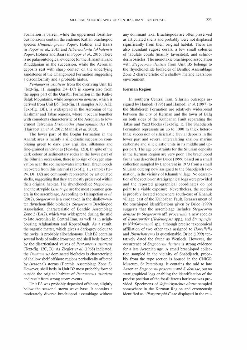
Formation is barren, while the uppermost fossilifer-ous horizons contain the endemic Katian brachiopod species Hindella prima Popov, Holmer and Baars in Popov et al., 2015 and Hibernodonta lakhalensis Popov, Holmer and Baars in Popov et al., 2015. There is no palaeontological evidence for the Hirnantian and Rhuddanian in the succession, while the Aeronian deposits rest with sharp contact on the underlying sandstones of the Chahgonbad Formation suggesting a disconformity and a probable hiatus.
Pentamerus asiaticus from the overlying Unit B2 (Text-fig. 11, samples D4−D7) is known also from the upper part of the Qarabil Formation in the Kuh-e Saluk Mountains, while Stegocornu denisae, which is derived from Unit B5 (Text-fig. 11, samples A30, A32; Text-fig. 13E), is widespread in the Aeronian of the Kashmar and Tabas regions, where it occurs together with conodonts characteristic of the Aeronian to low-ermost Telychian Distomodus staurognathoides CB (Hairapetian et al. 2012; Männik et al. 2013).
The lower part of the Boghu Formation in the Anarak area is mainly a siliciclastic succession com-prising green to dark grey argillites, siltstones and fine- grained sandstones (Text-fig. 12B). In spite of the dark colour of sedimentary rocks in the lower part of the Silurian succession, there is no sign of oxygen star-vation near the sediment-water interface. Brachiopods recovered from this interval (Text-fig. 11, samples P2‒P4, D1, D2) are commonly represented by articulated shells, suggesting that they are mostly preserved within their original habitat. The rhynchonellide Stegocornu and the atrypide Lissatrypa are the most common gen-era in the assemblage. According to Hairapetian et al. (2012), Stegocornu is a core taxon in the shallow-wa-ter rhynchonellide biofacies (Stegocornu Brachiopod Association) characteristic of Benthic Assemblage Zone 2 (BA2), which was widespread during the mid to late Aeronian in Central Iran, as well as in neigh-bouring Afghanistan and Kopet-Dagh. As a result, the organic matter, which gives a dark-grey colour to the rocks, is probably allochthonous. Unit B2 contains several beds of oolitic ironstone and shell beds formed by the disarticulated valves of Pentamerus asiaticus (Text-fig. 12C, D). As Ziegler et al. (1968) indicated, the Pentamerus dominated biofacies is characteristic of shallow shelf offshore regions periodically affected by (seasonal) storms (Benthic Assemblage Zone 3). However, shell beds in Unit B2 most probably formed outside the original habitat of Pentamerus asiaticus and result from strong storm events.
Unit B3 was probably deposited offshore, slightly below the seasonal storm wave base. It contains a moderately diverse brachiopod assemblage without
any dominant taxa. Brachiopods are often preserved as articulated shells and probably were not displaced significantly from their original habitat. There are also abundant rugose corals, a few small colonies of tabulate corals (mainly favositids), and echino-derm ossicles. The monotaxic brachiopod association with Stego cornu denisae from Unit B5 belongs to the rhynchonellide biofacies of Benthic Assemblage Zone 2 characteristic of a shallow marine nearshore environment.
Kerman Region
In southern Central Iran, Silurian outcrops as-signed by Hamedi (1995) and Hamedi et al. (1997) to the Shabdjereh Formation are relatively widespread between the city of Kerman and the town of Bafq on both sides of the Kuhbanan Fault separating the Tabas and Yazd blocks (Text-fig. 1). The Shabdjereh Formation represents an up to 1000 m thick hetero-lithic succession of siliciclastic fluvial deposits in the lower part and several intercalating shallow marine carbonate and siliciclastic units in its middle and up-per part. The age constraints for the Silurian deposits in the Kerman Region are very poor. The brachiopod fauna was described by Brice (1999) based on a small collection sampled by Lapparent in 1973 from a small Silurian outcrop now assigned to the Shabdjereh For-ma tion, in the vicinity of Khanuk village. No descrip-tion of the section or stratigraphical logs were provided and the reported geographical coordinates do not point to a viable exposure. Nevertheless, the section is probably located somewhere south-east of Khanuk village, east of the Kuhbaban Fault. Reassessment of the brachiopod identifications given by Brice (1999) suggests that the assemblage includes Stegocornu denisae (= Stegocornu aff. procerum), a new species of Iranospirifer (Hedeinopsis spp.), and Striispirifer (= Nikiforovaena? sp.), although precise taxonomical affiliation of two other taxa assigned to Howellella and Rhynchotrema is questionable. Brice (1999) ten-tatively dated the fauna as Wenlock. However, the occurrence of Stegocornu denisae is strong evidence for a late Aeronian age. A small brachiopod collec-tion sampled in the vicinity of Shabdjereh, proba-bly from the type section is housed in the CNIGR Museum, St Petersburg. It contains the mid to late Aeronian Stegocornu procerum and S. denisae, but no stratigraphical logs enabling the identification of the precise position of the fossiliferous horizons was pro-vided. Specimens of Jafarirhynchus alatus sampled somewhere in the Kerman Region and erroneously identified as “Platystrophia” are displayed in the mu-

224 VACHIK HAIRAPETIAN ET AL.
seum of the Iranian Geological Survey in Tehran, but no detailed collection site information is available. These specimens are the only evidence that part of the Shabdjereh Formation is Telychian in age.
Niko et al. (1999) reported on the occurrence of the orthoconic cephalopods, including Armenoceras banestanense Niko, Kakuva, Watanabe and Matsu-moto, 1999, Armenoceras sp., Elrodoceras sp. and Huroniella iranica Niko, Kakuva, Watanabe and Matsumoto, 1999 in the upper part of the Silurian succession in Banestan. They also included a strati-graphical column showing the position of the fos-siliferous horizons. According to their assessment, the age of the cephalopod fauna could be from late Llandovery to early Wenlock, the youngest age for the Shabdjereh Formation published to date. Hamedi et al. (1997) briefly noted that conodonts identified by R.J. Aldridge suggest a Llandovery to Pridoli age for the succession in the vicinity of Kerman but no faunal lists were provided to support that statement.
According to Hamedi (1995), the type section of the Shabdjereh Formation is located c. 6 km north-west of Shabdjereh village, to the west of the Kuhbanan Fault. Here Silurian deposits rest uncon-formably on the Ordovician Katkoyeh Formation and are unconformably overlain by the Lower Devonian Padeha Formation. The Silurian succession can be subdivided into 12 informal units as follows:
Unit 1. 83.3 m of dark-red siliciclastic rocks rep-resenting several cycles of stream channel and flood-plain deposits.
Unit 2. 63.9 m of intercalating sandstone, argil-lite, gypsiferous argillaceous limestone, limestone and dolostone.
Unit 3. 3 m of white quartz arenite with bidirec-tional cross bedding.
Unit 4. 214.2 m of dark, thin-bedded limestone, argillaceous limestone with salt pseudomorphs and calcareous sandstone.
Unit 5. 76.3 m of stromatolitic dolomite, calcare-ous sandstone and sandstone with a bed of conglom-erate with sandy matrix at the base.
Unit 6. 85.5 m of limestone, dolostone, argilla-ceous limestone and calcareous sandstone with salt pseudomorphs.
Unit 7. 137 m of cross-bedded sandstone inter-calating with argillite and a few thin interbeds of limestone.
Unit 8. 107.1 m of intercalating argillite, argilla-ceous limestone, thin-bedded limestone, dolostone and calcareous sandstone with a bed of matrix-sup-ported conglomerate less than 1 m thick at the base of the unit.
Unit 9. 30.7 m of cross-bedded sandstone and ar-gillite intercalations with a few beds of dolostone.
Unit 11. 32.1 m of several cycles of dark-red sand-stone and argillite couplets representing the transi-tion from supratidal to floodplain deposits.
Unit 12. 63.6 m of green argillite and sandstone intercalations with several thin beds of calcareous limestone.
Unit 13. 44 m of bedded yellow to grey dolostone. The total thickness of the Shabdjereh Formation
in its type section is 869 m.
Boz-Kuh
Alavi-Naini (1972) documented an isolated Silurian outcrop area in the Sabzevar Zone, in the Boz-Kuh area, c. 25 km north-east of the town of Djam, Semnan Province, and reported a thickness of c. 591 m assigned to the Bozkuh Formation. The succession comprises mainly siliciclastic rocks with beds of bioclastic limestone in its lower part and ba-salt to trachyandesite volcanic rocks in the middle part. The Silurian age of the formation is based on the occurrence of brachiopods and favositid tabulate cor-als in the lower part of the succession, but no further details were presented. Based on this limited infor-mation neither age nor palaeogeographical position of the area in relation to other Iranian terranes can be convincingly defined at present.
Talesh Mountains
Further north-west of Boz-Kuh, small Silurian outcrops were documented by Clark et al. (1975) in the Talesh Range, west of Rasht (SW of the Caspian Sea) between Aliyan Rud, Tatavrud and Rude-Qurubars (Masuleh), east of Tatavrud village. The Silurian deposits in the area are represented by thick-bedded red cephalopod limestone about 40 m thick (“unit 3” of Clark et al. 1975). Here the Silurian rocks rest paraconformably on Ordovician bioclastic limestones rich in trilobites of Katian age (Clark et al. 1975). The trilobites were described by Karim (2009). The Silurian (Telychian to middle Ludlow) age of the cephalopod limestone is supported by conodonts, collected from the lower and middle parts of “unit 3” in the Derow section (Hamdi 1975).
A condensed Upper Ordovician to Silurian car-bonate succession in the Tatavrud area has no analo-gies in other parts of Iran. Therefore it is likely that the lower Palaeozoic rocks in the Talesh Range belong to an exotic terrane. Moreover, the Ordovician trilobite fauna described by Karim (2009) shows similarity to
SILURIAN STRATIGRAPHY OF CENTRAL IRAN – AN UPDATE 225
that known from the Turkestan-Altai Region of the Tien Shan and Chu-Ili terrane in South Kazakhstan. At present the Silurian succession and fauna of the Talesh Range is poorly known so further discussion of the biogeographic position of the terrane and its affinity to other parts of Iran is problematical.
Soh Region
The only known Silurian deposits in the Sanan-daj- Sirjan terrane (Text-fig. 1) were documented by Zahedi (1973) in the Jehagh Anticline and Sargerd Mountains, north and east of Soh village. According to Zahedi (1973), the Silurian rocks, subdivided into 13 informal units, rest unconformably on the pre-sumably Cambrian−Lower Ordovician deposits of the “Mila Formation”. However, neither the age nor the lithostratigraphic affiliation of the underlying sedimentary succession can be confirmed at present.
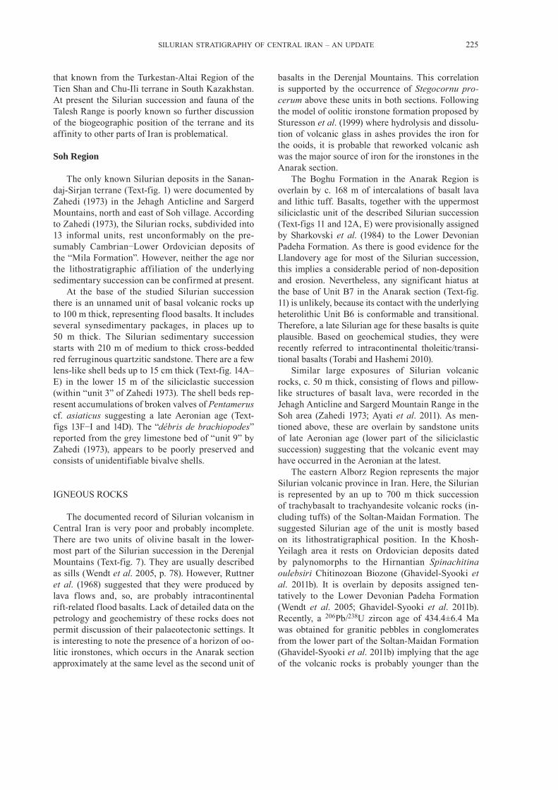
At the base of the studied Silurian succession there is an unnamed unit of basal volcanic rocks up to 100 m thick, representing flood basalts. It includes several synsedimentary packages, in places up to 50 m thick. The Silurian sedimentary succession starts with 210 m of medium to thick cross-bedded red ferruginous quartzitic sandstone. There are a few lens-like shell beds up to 15 cm thick (Text-fig. 14A–E) in the lower 15 m of the siliciclastic succession (within “unit 3” of Zahedi 1973). The shell beds rep-resent accumulations of broken valves of Pentamerus cf. asiaticus suggesting a late Aeronian age (Text-figs 13F−I and 14D). The “débris de brachiopodes” reported from the grey limestone bed of “unit 9” by Zahedi (1973), appears to be poorly preserved and consists of unidentifiable bivalve shells.
IGNEOUS ROCKS
The documented record of Silurian volcanism in Central Iran is very poor and probably incomplete. There are two units of olivine basalt in the lower-most part of the Silurian succession in the Derenjal Mountains (Text-fig. 7). They are usually described as sills (Wendt et al. 2005, p. 78). However, Ruttner et al. (1968) suggested that they were produced by lava flows and, so, are probably intracontinental rift-related flood basalts. Lack of detailed data on the petrology and geochemistry of these rocks does not permit discussion of their palaeotectonic settings. It is interesting to note the presence of a horizon of oo-litic ironstones, which occurs in the Anarak section approximately at the same level as the second unit of
basalts in the Derenjal Mountains. This correlation is supported by the occurrence of Stegocornu pro-cerum above these units in both sections. Following the model of oolitic ironstone formation proposed by Sturesson et al. (1999) where hydrolysis and dissolu-tion of volcanic glass in ashes provides the iron for the ooids, it is probable that reworked volcanic ash was the major source of iron for the ironstones in the Anarak section.
The Boghu Formation in the Anarak Region is overlain by c. 168 m of intercalations of basalt lava and lithic tuff. Basalts, together with the uppermost siliciclastic unit of the described Silurian succession (Text-figs 11 and 12A, E) were provisionally assigned by Sharkovski et al. (1984) to the Lower Devonian Padeha Formation. As there is good evidence for the Llandovery age for most of the Silurian succession, this implies a considerable period of non-deposition and erosion. Nevertheless, any significant hiatus at the base of Unit B7 in the Anarak section (Text-fig. 11) is unlikely, because its contact with the underlying heterolithic Unit B6 is conformable and transitional. Therefore, a late Silurian age for these basalts is quite plausible. Based on geochemical studies, they were recently referred to intracontinental tholeitic/transi-tional basalts (Torabi and Hashemi 2010).
Similar large exposures of Silurian volcanic rocks, c. 50 m thick, consisting of flows and pillow- like structures of basalt lava, were recorded in the Jehagh Anticline and Sargerd Mountain Range in the Soh area (Zahedi 1973; Ayati et al. 2011). As men-tioned above, these are overlain by sandstone units of late Aeronian age (lower part of the siliciclastic succession) suggesting that the volcanic event may have occurred in the Aeronian at the latest.
The eastern Alborz Region represents the major Silurian volcanic province in Iran. Here, the Silurian is represented by an up to 700 m thick succession of trachybasalt to trachyandesite volcanic rocks (in-cluding tuffs) of the Soltan-Maidan Formation. The suggested Silurian age of the unit is mostly based on its lithostratigraphical position. In the Khosh-Yeilagh area it rests on Ordovician deposits dated by palynomorphs to the Hirnantian Spinachitina oulebsiri Chitinozoan Biozone (Ghavidel-Syooki et al. 2011b). It is overlain by deposits assigned ten-tatively to the Lower Devonian Padeha Formation (Wendt et al. 2005; Ghavidel-Syooki et al. 2011b). Recently, a 206Pb/238U zircon age of 434.4±6.4 Ma was obtained for granitic pebbles in conglomerates from the lower part of the Soltan-Maidan Formation (Ghavidel-Syooki et al. 2011b) implying that the age of the volcanic rocks is probably younger than the

226 VACHIK HAIRAPETIAN ET AL.
SILURIAN STRATIGRAPHY OF CENTRAL IRAN – AN UPDATE 227
Llandovery. As the overlying Devonian deposits are faunally barren, a Silurian age for the whole unit is still possible. There are no granitic plutons of Silurian age yet reported from Alborz or from elsewhere in Iran (Ghavidel-Syooki et al. 2011b).
It is possible that the Soltan-Maidan volcanic suite formed at approximately the same time as basalts at the top of the Silurian succession in the Anarak area. At present, lack of evidence hampers any suggestion about a possible relationship between these two vol-canic events.
A link between the Soltan-Maidan volcanic rocks and flood basalt volcanism in the lower Palaeozoic succession of the Kopet-Dagh Region suggested by Wendt et al. (2005) is highly problematical: in Kopet-Dagh (Saluk Mountains) mafic volcanism has been reported from the Furongian (upper Cambrian) Eoconodontus notchpeakensis CB (Jahangir et al. 2015). Volcanism continued through the Ordovician and, based on the occurrence of oolitic ironstones in the upper part of the lower Aeronian graptolitic shales (Demirastrites triangulatus GB) in the Saluk Mountains (Evans et al. 2015), probably continued into the early Silurian.
BIOSTRATIGRAPHY AND CORRELATION
Available data about the Silurian successions from various parts of the Central-East Iranian Microplate (Hamedi 1995; Hairapetian et al. 2011; Männik et al. 2013; Popov et al. 2015a) suggest a widespread unconformity at the base of the Silurian in the re-gion (Text-fig. 15). In the Derenjal and Boghu moun-tains, the oldest Silurian deposits dated by conodonts are Aeronian (Männik et al. 2013). In the Kerman Region, the Upper Ordovician part of the Katkoyeh Formation is overlain by the Shabdjereh Formation. The lower part of the Shabdjereh Formation con-sists of deposits characteristic of alluvial systems suggesting subaerial exposure and widespread ero-sion during the latest Ordovician–earliest Silurian. A marine transgression probably commenced some-time in the mid Aeronian. This is indicated by the occurrence of Stegocornu procerum (Hairapetian et al. 2012).
A distinct lineage of endemic rhynchonellide bra-chiopods can been seen in the Llandovery of the Central Iran region: Stegocornu procerum→Stegocornu deni-sae→Jafarirhynchus alatus. The two species of Ste-gocornu succeed one another in the upper Aeronian strata (within the upper part of the Distomodus stau-rognathoides CB) and Jafarirhynchus alatus occurs in the Telychian (Hairapetian et al. 2012; Popov et al. 2015a). This lineage has also been recognised in Kopet-Dagh and Afghanistan. All of these species can be used for high resolution biostratigraphy and correlation of middle and upper Llandovery deposits within Central Iran and adjacent regions.
At present, deposits of Wenlock to Ludlow age are known only from the regions located along the north-ern margin of the Central-East Iranian Microplate. They are represented by the carbonate succession of the Dahaneh-Kalut Formation, which is dated by conodonts (Männik et al. 2013) and brachiopods. It is possible that the Dahaneh-Kalut section extends into the Pridoli but no age-diagnostic taxa have yet been recovered.
Outside Central Iran, Silurian deposits are rela-tively well documented in the Zagros Basin and in the Iranian Kopet-Dagh. In the Zagros Basin, the Silurian is represented by black graptolitic shales and overly-ing siliciclastic deposits of the Sarchahan Formation. Both are relatively widespread in the subsurface, but are exposed only in two small areas c. 100 km north of Bandar-Abbas, namely the Kuh-e Faraghan and Kuh-e Ghakum areas (Text-fig. 1). Kuh-e Faraghan is the only place in Iran where a continuous transition from the Ordovician to the Silurian is documented in the lowermost part of the Sarchahan Formation (Ghavidel-Syooki et al. 2011a). Biostratigraphy based on graptolites (Rickards et al. 2000; Ghavidel-Syooki et al. 2011a) and palynomorphs (Ghavidel-Syooki and Khosravi 1995; Ghavidel-Syooki 2000; Ghavidel-Syooki and Winchester-Seeto 2004; Ghavidel-Syooki et al. 2011a) suggests a Rhuddanian to Telychian age for the main part of the Silurian succession in the Zagros Basin. Rare brachiopods recently described and illustrated from the Sarchahan Formation include the lingulide Paterula sp. and spiriferide Iranospirifer sp. (Ghavidel-Syooki et al. 2015). The latter genus is endemic and occurs also in the Aeronian of Kopet-
Text-fig. 14. Field photographs of the Jehagh section in the vicinity of Soh village. A – Lower part of the Jehagh section, north-westerly view: exposure of an unnamed formation of volcanic rocks (V) unconformably overlain by mid to late Aeronian siliciclastic rocks (S) – those in white squares are detailed in the following photographs; B – Lava flows with interbedded packages and overlying beds of sandstone (S) (person for scale), westerly view of the exposure; C – Easterly view of the stratigraphic contact between volcanic rocks (V) and sandstone (S) (person for scale); D – Close-up view of a shell bed formed by accumulation of disarticulated valves of Pentamerus cf. asiaticus Cocks, 1979a;
E – Close-up view of the sandstone beds intercalating with thin layers of calcareous sandstone in the lower part of the section
→

228 VACHIK HAIRAPETIAN ET AL.
Dagh (Popov and Cocks 2013) and in the Kerman Region (Brice 1999).
The extensive occurrence of black graptolitic shales in the Zagros Basin, which occupied the outer margin of the Arabian sector of Gondwana through the Palaeozoic, is in sharp contrast with the Silurian successions documented elsewhere in Iran. Available data suggest also that the onset of the black shale deposition was diachronous across the Zagros Basin. At Kuh-e-Faraghan the base of the Sarchahan Formation is dated as the late Hirnantian Metabolograptus persculptus Graptolite Biozone (GB), while at Kuh-e-Gahkum the lowermost part of the formation contains graptolites of the early Aeronian Demirastrites triangulatus GB (Ghavidel-Syooki et al. 2011a). At Kuh-e-Faraghan there is a cryptic hiatus corresponding to the middle and upper Rhuddanian at the base of the Demirastrites triangulatus GB (Suyarkova, personal communica-tion 2012; Saberi et al. 2016; Text-fig. 12) and ev-idence for significant local scouring, which could have been produced by the direct action of ice abra-sion, melt-water, or a combination of both (Ghavidel-Syooki et al. 2011a). A prominent fan-shaped clastic wedge of amalgamated conglomerate sheets at Kuh-e-Gahkum was possibly deposited within a tun-nel-channel shoulder (Ghavidel-Syooki et al. 2015).
This may indicate that the Hirnantian satellite ice sheet was present in the Zagros area.
Unlike in the Zagros Basin, a widespread hiatus occurs at the Ordovician−Silurian boundary in the Central-East Iranian Microplate. Here, Hirnantian and most of Rhuddanian strata are missing, and shal-low marine deposition only commenced sometime in the Aeronian when heterolithic siliciclastic and car-bonate deposits yielding intervals with abundant bra-chiopod shells and small metazoan build-ups started to form.
The Silurian of Kopet-Dagh has been widely studied (Ghavidel-Syooki 1996; Ghavidel-Syooki and Vecoli 2007; Popov and Cocks 2013; Evans et al. 2015). However, there are still unresolved ques-tions, for example the Ordovician−Silurian boundary in that succession has not been defined. It is most probably within a thick siliciclastic succession sepa-rating the unnamed unit of Upper Ordovician flood basalts from the unit of graptolitic black shales with a few beds of oolitic ironstone, and with the graptolites of the lower Aeronian Demirastrites triangulatus GB in the upper part. In the Saluk Mountains, the unit of graptolitic black shales is up to 90 m thick (Evans et al. 2015). The middle part of the Silurian succession comprises mainly limestones with subsidiary beds of siltstone and argillite. These limestones have been
Text-fig. 15. General correlation of the Silurian formations in Iran based on all available data. For lithological explanations see Text-fig. 7. Lithologies within formations are generalized. Abbreviations: G. – Gorstian; Ho. – Homerian; Lud. – Ludfordian; Pri. – Pridoli; Rhud. –
Rhuddanian; Shein. – Sheinwoodian
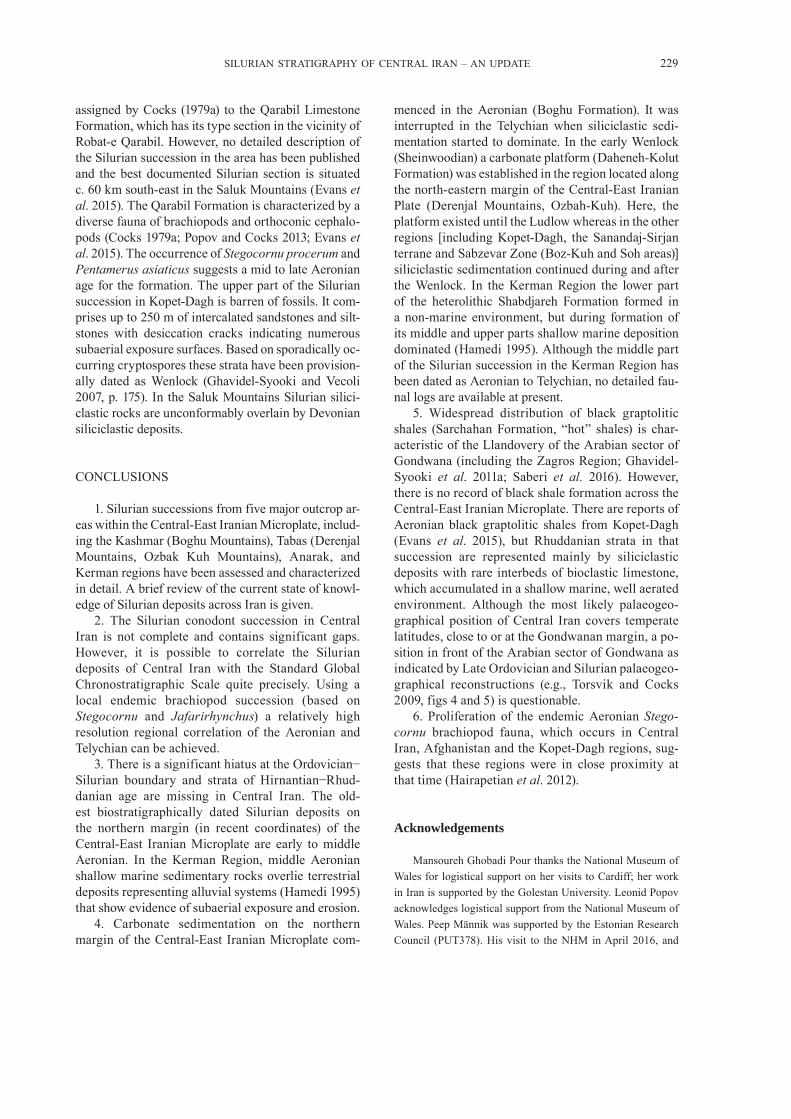
SILURIAN STRATIGRAPHY OF CENTRAL IRAN – AN UPDATE 229
assigned by Cocks (1979a) to the Qarabil Limestone Formation, which has its type section in the vicinity of Robat-e Qarabil. However, no detailed description of the Silurian succession in the area has been published and the best documented Silurian section is situated c. 60 km south-east in the Saluk Mountains (Evans et al. 2015). The Qarabil Formation is characterized by a diverse fauna of brachiopods and orthoconic cephalo-pods (Cocks 1979a; Popov and Cocks 2013; Evans et al. 2015). The occurrence of Stegocornu procerum and Pentamerus asiaticus suggests a mid to late Aeronian age for the formation. The upper part of the Silurian succession in Kopet-Dagh is barren of fossils. It com-prises up to 250 m of intercalated sandstones and silt-stones with desiccation cracks indicating numerous subaerial exposure surfaces. Based on sporadically oc-curring cryptospores these strata have been provision-ally dated as Wenlock (Ghavidel-Syooki and Vecoli 2007, p. 175). In the Saluk Mountains Silurian silici-clastic rocks are unconformably overlain by Devonian siliciclastic deposits.
CONCLUSIONS
1. Silurian successions from five major outcrop ar-eas within the Central-East Iranian Microplate, includ-ing the Kashmar (Boghu Mountains), Tabas (Derenjal Mountains, Ozbak Kuh Mountains), Anarak, and Kerman regions have been assessed and characterized in detail. A brief review of the current state of knowl-edge of Silurian deposits across Iran is given.
2. The Silurian conodont succession in Central Iran is not complete and contains significant gaps. However, it is possible to correlate the Silurian deposits of Central Iran with the Standard Global Chronostratigraphic Scale quite precisely. Using a local endemic brachiopod succession (based on Stegocornu and Jafarirhynchus) a relatively high resolution regional correlation of the Aeronian and Telychian can be achieved.
3. There is a significant hiatus at the Ordovician−Silurian boundary and strata of Hirnantian−Rhud-danian age are missing in Central Iran. The old-est biostratigraphically dated Silurian deposits on the northern margin (in recent coordinates) of the Central-East Iranian Microplate are early to middle Aeronian. In the Kerman Region, middle Aeronian shallow marine sedimentary rocks overlie terrestrial deposits representing alluvial systems (Hamedi 1995) that show evidence of subaerial exposure and erosion.
4. Carbonate sedimentation on the northern margin of the Central-East Iranian Microplate com-
menced in the Aeronian (Boghu Formation). It was interrupted in the Telychian when siliciclastic sedi-mentation started to dominate. In the early Wenlock (Sheinwoodian) a carbonate platform (Daheneh-Kolut Formation) was established in the region located along the north-eastern margin of the Central-East Iranian Plate (Derenjal Mountains, Ozbah-Kuh). Here, the platform existed until the Ludlow whereas in the other regions [including Kopet-Dagh, the Sanandaj-Sirjan terrane and Sabzevar Zone (Boz-Kuh and Soh areas)] siliciclastic sedimentation continued during and after the Wenlock. In the Kerman Region the lower part of the heterolithic Shabdjareh Formation formed in a non-marine environment, but during formation of its middle and upper parts shallow marine deposition dominated (Hamedi 1995). Although the middle part of the Silurian succession in the Kerman Region has been dated as Aeronian to Telychian, no detailed fau-nal logs are available at present.
5. Widespread distribution of black graptolitic shales (Sarchahan Formation, “hot” shales) is char-acteristic of the Llandovery of the Arabian sector of Gondwana (including the Zagros Region; Ghavidel-Syooki et al. 2011a; Saberi et al. 2016). However, there is no record of black shale formation across the Central-East Iranian Microplate. There are reports of Aeronian black graptolitic shales from Kopet-Dagh (Evans et al. 2015), but Rhuddanian strata in that succession are represented mainly by siliciclastic deposits with rare interbeds of bioclastic limestone, which accumulated in a shallow marine, well aerated environment. Although the most likely palaeogeo-graphical position of Central Iran covers temperate latitudes, close to or at the Gondwanan margin, a po-sition in front of the Arabian sector of Gondwana as indicated by Late Ordovician and Silurian palaeogeo-graphical reconstructions (e.g., Torsvik and Cocks 2009, figs 4 and 5) is questionable.
6. Proliferation of the endemic Aeronian Stego-cornu brachiopod fauna, which occurs in Central Iran, Afghanistan and the Kopet-Dagh regions, sug-gests that these regions were in close proximity at that time (Hairapetian et al. 2012).
Acknowledgements
Mansoureh Ghobadi Pour thanks the National Museum of Wales for logistical support on her visits to Cardiff; her work in Iran is supported by the Golestan University. Leonid Popov acknowledges logistical support from the National Museum of Wales. Peep Männik was supported by the Estonian Research Council (PUT378). His visit to the NHM in April 2016, and

230 VACHIK HAIRAPETIAN ET AL.
the use of the SEM to study conodonts, was financed by the SYNTHESYS Project GB-TAF-6163. We thank Profs. Bradley D. Cramer, David Loydell, and Mehmet Cemal Göncüoglu for insightful comments on the manuscript.
REFERENCES
Alavi, M. 1991. Tectonic map of the Middle East: Tehran, Geo-logical Survey of Iran, scale 1:5,000,000.
Alavi-Naini, M. 1972. Etude géologique de la région de Djam. Geological Survey of Iran, Reports, 23, 1–288.
Armstrong, H.A. 1996. Biotic recovery after mass extinction: the role of climate and ocean-state in the post-glacial (late Ordo-vician–early Silurian) recovery of the conodonts. In: M.B. Hart (Ed.), Biotic recovery from mass extinction events. Geological Society Special Publication, 102, 105−117.
Ayati, F., Noghreyan, M. and Khalili, M. 2011. A review of Pa-laeozoic magmatism in central Iran. Journal of crystallog-raphy and mineralogy of Iran, 18, 615−632. [In Farsi with English summary]
Barlii, B.G. 1986. A biometric re-evaluation of the Silurian bra-chiopod lineage Stricklandia lens/S. laevis. Palaeontology, 29, 187−205.
Berberian, M. and King, G.C.P. 1981. Towards a paleogeog-raphy and tectonic evolution of Iran. Canadian Journal of Earth Science, 18, 210–265.
Berry, W.B.N. and Boucot, A.J. 1972. Correlation of the south-east Asian and Near Eastern Silurian rocks. Geological So-ciety of America Special Papers, 137, 1−36.
Bischoff, G.C.O. 1986. Early and middle Silurian cono-donts from midwestern New South Wales. Courier For-schungsinstitut Senckenberg, 89, 1−336.
Boucot, A.J. 1975. Evolution and extinction rate controls, 1−427. Elsevier; Amsterdam, Oxford, New York.
Branson, E.B. and Branson, C.C. 1947. Lower Silurian Cono-donts from Kentucky. Journal of Paleontology, 21, 549−556.
Branson, E.B. and Mehl, E.B. 1933. Conodonts from the Ma-quoketa-Thebes (Upper Ordovician) of Missouri. The Uni-versity of Missouri Studies, 8, 121−131.
Brice, D. 1999. Middle (?) Silurian rhynchonellid and spiriferid brachiopod faunas from eastern central Iran. Annales de la Société géologique du Nord, 7, 5−12.
Bruton, D.L., Wright, A.J. and Hamedi, M.A. 2004. Ordovician trilobites of Iran. Palaeontographica, Abteilung, A271, 111−149.
Clark, G.C., Davies, R., Hamzepour, B. and Jones, C.R. (with contributions by Ghorashi, M. Hamdi, B. and Navai, N.) 1975. Explanatory text of the Bandar-e-Pahlavi quadrangle map. Geological Survey of Iran, Tehran, D3, 1−198.
Cocks, L.R.M. 1979a. A silicified brachiopod fauna from the Silurian of Iran. Bulletin of the British Museum (Natural History), Geology, 32, 25−42.
Cocks, L.R.M. 1979b. New acrotretacean brachiopods from the Palaeozoic of Britain and Austria. Palaeontology, 22, 93−100.
Cocks, L.R.M. 2008. A revised review of British Lower Palaeo-zoic brachiopods. Palaeontographical Society Monograph, 161, 1–276.
Cocks, L.R.M. and Rong, Y. 2008 (for 2007). Earliest Siluri-an faunal survival and recovery after the end Ordovician glaciation: evidence from the brachiopods. Earth and En-vironmental Science Transactions of the Royal Society of Edinburgh, 98, 291–301.
Copeland, M.J. 1974. Silurian ostracoda from Anticosti Island, Quebec. Geological Survey of Canada Bulletin, 241, 1−133.
Cramer, B.D., Brett, C.E., Melchin, M.J., Männik, P., Kleff-ner, M.A., McLaughlin, P.I., Loydell, D.K., Munnecke, A., Jeppsson, L., Corradini, C. and Brunton, F.R. 2011. Revised correlation of Silurian Provincial Series of North America with global and regional chronostratigraphic units and δ13Ccarb chemostratigraphy. Lethaia, 44, 185−202.
Dubatolov, V.N. 1956. Tabulate and heliolitid corals from north- eastern Prisalairiye. Ezhegodnik Vsesoyuznogo Paleontolo-gicheskogo obshchestva, 15, 83–122.
Dürkoop, A. 1970. Brachiopoden aus dem Silur, Devon und Karbon in Afghanistan. Palaeontographica, Series A, 134, 153−225.
Etheridge, R. 1890. On the occurrence of the genus Tryplasma Lonsdale (Pholidophyllum Lindström) and another cor-al apparently referable to Diphyphyllum Lonsdale, in the Upper Silurian and Devonian rocks, respectively, of New South Wales. Records of the Geological Survey of New South Wales, 2, 15−21.
Evans, D.H., Ghobadi Pour, M., Popov, L.E. and Jahangir, H. 2015. An Early Silurian (Aeronian) cephalopod fauna from Kopet-Dagh, north-eastern Iran: including the earliest re-cords of non-orthocerid cephalopods from the Silurian of Northern Gondwana. Bulletin of Geosciences, 90, 479−507.
Fischer-Benzon, R.J.D. von 1871. Mikroskopische Untersu-chungen über die Struktur der Halysites-Arten und einiger silurischer Gesteine aus den russischen Ostsee-Provinzen. Abhandlungen aus dem Gebiete der Naturwissenschaften, Hamburg, 5, 9−23.
Flügel, E. 1962. Korallen aus dem Silur fon Uzbak-Kuh (NE Iran). Jahrbuch der Geologischen Bundesanstalt, 105, 287−300.
Flügel, E. 1969. Stromatoporen aus dem Silur des östlichen Iran. Neues Jahrbuch für Geologie und Paläontologie, Monatshefte, 1969, 209−129.
Flügel, H.W. and Saleh, H. 1970. Die paläozoischen Korallenfau-na Ost-irans. 1 Rugose Korallen der Niur Formation (Silur). Jahrbuch der Geologischen Bundesanstalt, 113, 267−302.
Ghavidel-Syooki, M. 1996. Acritarch biostratigraphy of the Palaeozoic rock units in the Zagros Basin, Southern Iran. In: O. Fatka and T. Servais (Eds), Acritarcha in Praha,

SILURIAN STRATIGRAPHY OF CENTRAL IRAN – AN UPDATE 231
Proceedings of International Meeting and Workshop. Acta Universitatis Carolinae, Geologica, 40, 385–411.
Ghavidel-Syooki, M. 2001. Biostratigraphy and palaeobioge-ography of Late Ordovician and Early Silurian chitinozo-ans from Zagros Basin, Southern Iran. Historical Biology, 15, 29−39.
Ghavidel-Syooki, M. 2003. Palynostratigraphy and palaeo-geography of Lower Paleozoic strata at Kuh-e-Boghou, southwest of Kashmar city, at eastern Central Iran. Iranian International Journal of Science, 4, 181−207.
Ghavidel-Syooki, M., Álvaro, J.J., Popov, L.E., Ghobadi Pour, M., Ehsani, M.H. and Suyarkova, A. 2011a. Stratigraphic evidence for the Hirnantian (latest Ordovician) glaciation in the Zagros Mountains, Iran. Palaeogeography, Palaeo-climatology, Palaeoecology, 307, 1−16.
Ghavidel-Syooki, M., Hassanzadeh, J. and Vecoli, M. 2011b. Palynology and isotope geochronology of the Upper Or-dovician–Silurian successions (Ghelli and Soltan Maidan Formations) in the Khoshyeilagh area, eastern Alborz Range, northern Iran; stratigraphic and palaeogeographic implications. Review of Palaeobotany and Palynology, 164, 251−271.
Ghavidel-Syooki, M. and Khosravi, M.E. 1995. Investigation of Lower Palaeozoic sediments at Tang-e-Zakeen of Kuh Faraghan and introduction of Seyahou and Sarchahan for-mations in Zagros basin, southern Iran. Geocience, Scien-tific Quarterly Journal, 4, 2–21.
Ghavidel-Syooki, M., Popov, L.E., Ghobadi Pour, M., Álvaro, J.J. and Ehsani, M.H. 2015. Late Ordovician and early Silu-rian brachiopods from the Zagros Ranges, Iran. Earth and Environmental Science Transactions of the Royal Society of Edinburgh, 105, 159−187.
Ghavidel-Syooki, M. and Vecoli, M. 2007. Latest Ordovician–early Silurian chitinozoans from the eastern Alborz Moun-tain Range, Kopet-Dagh region, northeastern Iran: biostra-tigraphy and palaeobiogeography. Review of Palaeobotany and Palynology, 145, 173–192.
Ghavidel-Syooki, M. and Winchester-Seeto, T. 2004. Chitino-zoan biostratigraphy and palaeogeography of lower Silu-rian strata (Sarchahan Formation) in the Zagros Basin of Southern Iran. Memoirs of the Association of Australasian Palaeontologists, 29, 161–182.
Ghobadi Pour, M., Williams, M., Vannier, J., Meidla, T. and Popov, L.E. 2006. Ordovician records from east central Iran. Acta Palaeontologica Polonica, 51, 551−560.
Goldfuss, G.A. 1826. Petrefacta Germaniae, Teil 1. Düsseldorf, 77−164, pl. 26−50.
Golonka, J. 2012. Paleozoic paleoenvironment and paleolitho-facies maps of Gondwana. Kwartalnik AGH. Geologia, 33, 1–82.
Hairapetian, V., Blom, H. and Miller, C.G. 2008. Silurian thelo-donts from the Niur Formation, central Iran. Acta Palaeon-tologica Polonica, 53, 85–95.
Hairapetian, V., Ghobadi Pour, M., Popov, L.E., Hejazi, S.H., Holmer, L.E., Evans, D. and Sharafi, A. 2015. Ordovi-cian of the Anarak Region: implications in understanding Early Palaeozoic history of Central Iran. Stratigraphy, 12, 22−30.
Hairapetian, V., Ghobadi Pour, M., Popov, L.E. and Modzalev-skaya, T.L. 2012. Stegocornu and associated brachiopods from the Silurian (Llandovery) of Central Iran. Estonian Journal of Earth Sciences, 61, 82–104.
Hairapetian, V., Mohibullah, M., Tilley, L.J., Williams, M., Miller, C.G., Afzal, J., Ghobadi Pour, M. and Hassan He-jazi, S. 2011. Early Silurian carbonate platform ostracods from Iran: a peri-Gondwanan fauna with strong Laurentian affinities. Gondwana Research, 20, 645–553.
Hamdi, B. 1975. Conodont studies on the Upper Silurian–Low-er Devonian of the Kolur area, east Azarbayjan. Geological Survey of Iran, Geological Quadrangle, D3, 153−171.
Hamedi, M.A. 1995. Lower Palaeozoic sedimentology and stratigraphy of the Kerman region, East-Central Iran. Ph.D. thesis, University of Wollongong, New South Wales, Aus-tralia, 1−307.
Hamedi, M.A.,Wright, A.J., Aldridge, R.J., Boucot, A.J., Bru-ton, D.L., Chatterton, B.D.E., Jones, P., Nicoll, R S., Rick-ards, R.B. and Ross, J.R.P. 1997. Cambrian to Silurian of East-Central Iran: new biostratigraphic and biogeograph-ic data. Neues Jahrbuch für Geologie und Paläontologie, Monatshefte, 7, 412−424.
Hubmann, B. 1991. Halysitidae aus dem tiefen Silur E-Irans (Niur-Formation). Jahrbuch der Geologischen Bundesan-stalt, 134, 711−733.
Huckriede, R., Kursten, M. and Venzlaff, H. 1962. Zur Geolo-gie des Gebietes zwischen Kerman und Sagand (Iran). Bei-hefte zum Geologischen Jahrbuch, 51, 1−197.
Jahangir, H., Ghobadi Pour, M., Holmer, L.E., Popov, L.E., Ashu-ri, A.-R., Rushton, A.W.A, Tolmacheva, T.Yu. and Amini, A. 2015. Biostratigraphy of the Cambrian–Ordovician bound-ary beds at Kopet-Dagh, Iran. Stratigraphy, 12, 40−47.
Kalantari, A. 1981. Iranian fossils. National Iranian Oil Com-pany, Geological Laboratories, 9, 1−216.
Karim, T.S. 2009. Late Ordovician trilobites from northwest Iran and their biogeographical affinities. Earth and En-vironmental Science Transactions of the Royal Society of Edinburgh, 99 (for 2008), 101−124.
Kiær, J. 1930. Den fossilførende ordovicisk-siluriske lagrekke på Stord og bemerkninger om de øvrige fossilfunn i Bergens-feltet. Bergens Museums Aarbog (for 1929), 11, 48−69.
Lamarck, J.Β.P.A. de 1816. Histoire naturelle des animaux sans vertèbres, II. 1−568. Verdière; Paris.
Lindenberg, H.G., Gröler, K., Jacobshagen, V. and Ibbeken, H. 1984. Post-Paleozoic stratigraphy, structure and orogenet-ic evolution of the southern Sabzevar zone and the Taknar block. Neues Jahrbuch für Geologie und Paläontologie, Abhhandlungen, 168, 287−326.

232 VACHIK HAIRAPETIAN ET AL.
Linnaeus, C. 1767. Systema naturæ, Tom. I. Pars II. Editio duo-decima reformata. pp. 533−1327 [1−37]. Holmiæ. (Salvius).
Lonsdale, W. 1839. Corals. In: R.I. Murchison, The Silurian System. 675−694.
Loydell, D.K., Nestor, V. and Männik, P. 2010. Integrated bio-stratigraphy of the lower Silurian of the Kolka-54 core, Latvia. Geological Magazine, 147, 253−280.
Männik, P. 1998. Evolution and taxonomy of the Silurian cono-dont Pterospathodus. Palaeontology, 41, 1001–1050.
Männik, P., Miller, C.G. and Hairapetian, V. 2013. Conodonts from the Niur Formation (Silurian) of the Derenjal Moun-tains, Central Iran. Geological Magazine, 150, 639−650.
Männik, P., Miller, C.G. and Hairapetian, V. 2015. A new ear-ly Silurian prioniodontid conodont with three P elements from Iran and associated species. Acta Palaeontologica Polonica, 60, 733–746.
Männik, P., Tinn, O., Loydell, D.K. and Ainsaar, L. 2016. Age of the Kalana Lagerstätte, early Silurian, Estonia. Estonian Journal of Earth Sciences, 65, 105−114.
McCoy, F. 1850. On some new genera and species of Silurian Radiata in the Collection of the University of Cambridge. Annals and Magazine of Natural History, 6, 270−290.
Melnikova, L.M. and Michailova, E.D. 1999. Late Ashgill–Early Llandovery ostracodes from the Zeravshan-Gissar mountainous region (Shakhriomon-II reference section): Platycopida, Metacopida and Podocopida. Paleontological Journal, 33, 392−402.
Milne-Edwards, H. and Haime, J. 1851. Monographie des Polypiers fossiles des terrains paléozoïques. Archives du Muséum d’Histoire Naturelles, 5, 1−502.
Neckaya, A.I. 1958. New species and genera of ostracodes of the Ordovician and Silurian of the Russian platform. Trudy VNIGRI, 115, 349−373.
Nicholson, A. and Etheridge, R. 1879. Descriptions of Palaeo-zoic corals from North Queensland. Annals and Magazine of Natural History, 4 (5), 216−226, 265−285.
Nikiforova, O.I. (Ed.) 1955. Field atlas of the Ordovician and Silurian fauna of the Siberian Platform, 266 pp. Gos-geoltekhizdat; Leningrad.
Niko, S., Kakuva, Y., Watanabe, D. and Matsumoto, R. 1999. Early Silurian actinoceratid and orthoceratid cephalopods from the Kerman area, East-Central Iran. Palaeontological Research, 3, 41–48.
Pollock, C.A., Rexroad, C.B. and Nicoll, R.S. 1970. Lower Silurian conodonts from northern Michigan and Ontario. Journal of Paleontology, 44, 743−746.
Popov, L.E. and Cocks, L.R.M. 2013. The radiation of early Silurian spiriferide brachiopods, with new taxa from the Llandovery of Iran. Alcheringa, 37, 558−564.
Popov, L., Hairapetian, V., Ghobadi Pour, M., Buttler, C., Ev-ans, D.H., Hejazi, S.H. and Jahangir, H. 2014. Llandovery fauna of Iran during the post-extinction recovery. The Third International Symposium of the International Geosciences
Programme Project 589 (IGCP-589): Development of the Asian Tethyan Realm: genesis, process and outcomes, Teh-ran, 19−26 October, 2014. Abstract volume and proceed-ings, 105−110.
Popov, L.E., Hairapetian, V., Ghobadi Pour, M., and Modza-levskaya, T.L. 2015a. A new, unusual rhynchonellide bra-chiopod with a strophic shell from the Silurian of Iran. Acta Palaeontologica Polonica, 60, 747–754.
Popov, L.E., Hairapetian, V., Evans, D.H., Ghobadi Pour, M., Holmer, L.E. and Baars, C. 2015b. Review of the Ordovi-cian stratigraphy and fauna of the Anarak Region in Central Iran. Acta Geologica Polonica, 65, 403–435.
Popov, L.E., Holmer, L.E., Bassett, M.G., Ghobadi Pour, M. and Percival, I.G. 2013. Chapter 10: Biogeography of Ordovician linguliform and craniiform brachiopods. In: D.A.T. Harper and T. Servais (Eds), Early Palaeozoic Bio-geography and Palaeogeography. Geological Society, Lon-don, Memoirs, 38, 117−126.
Popov, L.E., Kebriaee-Zadeh, M.R. and Ghobadi Pour, M. 2016. Emergence of the Saucrorthis Fauna in the Middle Ordovician of northern Iran. Australasian Palaeontologi-cal Memoirs, 49, 485−514.
Ramezani, J. and Tucker, R.D. 2003. The Saghand region, central Iran: U-Pb geochronology, petrogenesis and impli-cations for Gondwana tectonics. American Journal of Sci-ence, 303, 622–665.
Rhodes, F.H.T. 1953. Some British Lower Palaeozoic conodont faunas. Philosophical Transactions of the Royal Society of London, Series B, 237, 261−334.
Rickards, R.B., Wright, A.J., and Hamedi, M.A. 2000. Late Or-dovician and Early Silurian graptolites from southern Iran. Records of the Western Australian Museum, Supplement 58, 103−122.
Rong, J. and Cocks, L.R.M. 2014. Global diversity and ende-mism in Early Silurian (Aeronian) brachiopods. Lethaia, 47, 77–106.
Rubel, M. 2011. Silurian brachiopods Dictyonellida, Stro-phomenida, Productida, Orthotetida, Protorthida and Or-thida from Estonia. Fossilia Baltica, 4, 1–133.
Ruttner, A., Nabavi, M.H. and Hajian, J. 1968. Geology of the Shirgesht area (Tabas area, East Iran). Geological Survey of Iran, Reports, 4, 1–133.
Saberi, M.H., Rabbani, A.R. and Ghavidel-Syooki, M. 2016. Hydrocarbon potential and palynological study of the Lat-est Ordovician–Earliest Silurian source rock (Sarchahan Formation) in the Zagros Mountains, southern Iran. Marine and Petroleum Geology, 71, 12–25.
Sharkovski, M., Susov, M. and Krivyakin, B. (Eds) 1984. Ge-ology of the Anarak area (Central Iran), Explanatory text of the Anarak quadrangle map, 1:250,000, V/O Technoexport Report, 19, 1–143. Geological Survey of Iran; Tehran.
Sokolov, B.S. 1951. Palaeozoic tabulate corals of the European part of the USSR. Part 2. Silurian of the East Baltic (fa-

SILURIAN STRATIGRAPHY OF CENTRAL IRAN – AN UPDATE 233
vositids of the Llandovery Stage). Trudy VNIGRI, novaya seriya, 52, 1−124.
Sokolov, B.S. 1952. Palaeozoic tabulate corals of the European part of the USSR. Part 3. Silurian of the East Baltic (fa-vositids of Wenlock and Ludlow stages). Trudy VNIGRI, novaya seriya, 58, 1–85.
Stasińska, A. 1967. Tabulata from Norway, Sweden and from the Erratic Boulders of Poland. Palaeontologica Polonica, 18, 9−112.
Steusloff, A. 1895. Neue Ostrakoden aus Diluviageschieben von Neu-Brandenburg. Zeitschrift der Deutschen Geolo-gischen Gesellschaft, 46, 775−787.
Stocklin, J. and Setudehnia, A. 1991. Stratigraphic Lexicon of Iran. Geological Survey of Iran, Reports, 18, 1−376.
Stumm, E.C. 1954. A Devonian species of Heliolites from Ne-vada. Contributions from the Museum of Paleontology, University of Michigan, 11, 223−228.
Stumm, E.C. 1964. Silurian and Devonian corals of the Falls of the Ohio. Geological Society of America Memoirs, 93, 1−252.
Sturesson, U., Dronov, A. and Saadre, T. 1999. Lower Ordovi-cian iron ooids and associated oolitic clays in Russia and Estonia: a clue to the origin of iron oolites? Sedimentary Geology, 123, 63−80.
Sytova, V.A. 1968. Tetracorals from the Skaly and Borshchov horizons of Podolia. In: Z.G. Balashov (Ed.), Silurian−De-vonian fauna of Podoliya. Nauchno-issledovatelskii institut zemnoi kory, Paleontologicheskaya laboratoriya, Lenin-gradskii Universitet, Leningrad, 51–71. [In Russian]
Taheri, J. and Shamanian, G. 2001. Geological Map of Quad-rangle Kashmar, map 7660, 1:100,000. Geological Survey of Iran; Tehran.
Torabi, G. and Hashemi, F. 2010. Petrology of Devonian basalts in the Pole-Khavand area (Southeast of Anarak, Northeast of Isfahan). Petrology, 1, 29−46. [In Farsi]
Torsvik, T.H. and Cocks, L.R.M. 2009. The Lower Palaeozoic palaeogeographical evolution of the northeastern and east-ern peri-Gondwanan margin from Turkey to New Zealand. Special Publications of the Geological Society, London, 325, 3–21.
Torsvik, T.H. and Cocks, L.R.M. 2013. Gondwana from top to base in space and time. Gondwana Research, 24, 999–1030.
Tschernychev, B.B. 1937. Palaeontology of the Soviet Arctic, 1. Trudy Vsesojuznogo Arkticheskogo Instituta, 91, 67–13. [In Russian]
Walliser, O.H. 1964. Conodonten des Silurs. Abhandlungen der hessischen Landesamtes Bodenforschung, 41, 1–106.
Weddige, K. 1984. Zur Stratigraphy und Paläontologie des Dev-
ons und carbons von NE-Iran. Senckenbergiana lethaea, 65, 179−224.
Wedekind, R. 1927. Die Zoantharia Rugosa von Gotland. Sveriges Geologiska Undersökning, serie Ca, 19, 1–94.
Weissermel, W. 1939. Obersilurische und devonische Koral-len, Stromatoporiden und Trepostome von der Prinzen-insel Antirovitha und aus Bithynien. Abhandlungen der Preußischen Geologischen Landesanstalt, 190, 1–132.
Wendt, J., Kaufmann, B., Belka, Z., Farsan, N. and Karimi Ba-vandpur, A. 2002. Devonian/Lower Carboniferous stratig-raphy, facies patterns and palaeogeography of Iran. Part I. Southeastern Iran. Acta Geologica Polonica, 52, 129–168.
Wendt, J., Kaufmann, B., Belka, Z., Farsan, N. and Karimi Ba-vandpur, A. 2005. Devonian/Lower Carboniferous stratig-raphy, facies patterns and palaeogeography of Iran. Part II: Northern and central Iran. Acta Geologica Polonica, 55, 31–97.
Wensink, H. 1991. Late Precambrian and Paleozoic rocks of Iran and Afghanistan. In: M. Moullade and A.E.M. Nairn (Eds), The Phanerozoic geology of the world, I, The Pa-laeozoic, A, 147–218. Elsevier; Amsterdam, Oxford, New York, Tokyo.
Whitfield, R.P. 1882. Descriptions of new species of fossils from the Paleozoic Formation of Wisconsin. Part III. Pale-ontology. Annual report of the Wisconsin Geological Sur-vey, Survey of 1873−1879, 4, 161–363.
Williams, A. 1951. Llandovery brachiopods from Wales with special reference to the Llandovery district. Quarterly Journal of the Geological Society, London, 107, 85–136.
Wolfart, R. 1981. Lower Palaeozoic rocks of the Middle East. In: C.H. Holland (Ed.), Lower Palaeozoic rocks of the Middle East, Eastern and Southern Africa and Antarctica, 5–130. John Wiley and Sons; Chichester, New York, Bris-bane, Toronto.
Wright, A.D. 1968. Brachiopod Dicoelosia biloba (Linnaeus) and related species. Arkiv for Zoologi, series 2, 20, 261–319.
Yabe, H. 1915. Einige Bemerkungen über die Halysites-Arten. Science reports of the Tohoku Imperial University. 2nd se-ries, Geology, 4, 25–38.
Yabe, H and Egtjchi, M. 1945. Spongophyllum from the Middle Gotlandian Limestone of Erhtaokou near Kiturin, Mansyu. Proceedings of the Imperial Academy of Japan, 21, 431−434.
Zahedi, M. 1973. Étude géologique de la région de Soh (W de l’Iran central). Geological Survey of Iran, Reports, 27, 1−197.
Ziegler, A.M., Cocks, L.R.M. and Bambach, R.K. 1968. The composition and structure of Lower Silurian marine com-munities. Lethaia, 1, 1−27.
Manuscript submitted: 14th November 2016Revised version accepted: 23rd February 2017