sikkim earthquake
DESCRIPTION
sikkim earthquakeTRANSCRIPT

Observations from Damages Sustained in India during 2011 (India-Nepal) Sikkim Earthquake C. V. R. Murty, Arun Menon, Rupen Goswami, A. R. Vijaya Narayanan, S. R. Gandhi, K. N. Satyanarayana, S. T. G. Raghukanth Indian Institute of Technology Madras, Chennai, India Arvind Jaiswal EON Designers, Secunderabad, India Alpa Sheth VMS Consultants Pvt. Ltd., Mumbai, India SUMMARY The Mw 6.9 event near the Nepal-Sikkim border on 18 September 2011 (18:10 local time) (re)emphasised many lessons on technical, techno-legal and techno-financial systems related to development of built-environment in the region. Major observations include: lack of technical support in landslide potential assessment of hill slopes; traditional constructions abandoned by formal actions of government; Buddhist heritage structures almost erased; recent RC constructions are not earthquake-resistant; techno-legal regime absent - recent constructions unregulated with no quality control and quality assurance processes; post-earthquake damage assessment not understood by local engineers; owners continuing to live in damaged buildings after the earthquake without formally assessing safety of their buildings; and insufficient numbers of engineers and architect in the state of Sikkim with requisite background in earthquake resistant design and construction technology. Keywords: buildings; lifeline systems; landslides; Buddhist monasteries; traditional housing 1. INTRODUCTION The Mw 6.9 earthquake near the Nepal-Sikkim border on 18 September 2011 (18:10 local time) triggered a large number of landslides and caused significant damage to buildings and infrastructure. Significant losses of life and property occurred in three neighbouring countries – India, Nepal and Bhutan. In India, losses were in the states of Sikkim, Bihar and West Bengal, with Sikkim being the worst hit (Figure 1.1). In Sikkim, North Sikkim district was the worst affected (Murty et al, 2011). The state of Sikkim lies on the Himalayan mountain range with the two main thrust faults, Main Boundary Thrust (MBT) and Main Central Thrust (MCT), crossing the state. Sikkim has been a moderately active seismic region in historical times, in contrast to the other regions along the Indian Himalayas. In the last 50 years, the significant events in the region include 19 November 1980 Mw 6.0 Sikkim earthquake, and 21 August 1988 Mw 6.5 Bihar-Nepal earthquake. Detailed analysis of the seismotectonic features in the Sikkim Himalayan region indicates that movements along Gangtok Lineament and Teesta Lineament, which lie transverse to the Himalaya, are responsible for many earthquakes, including the 18 September 2011 event. The epicentre of this event (as reported by IMD) is shown in Figure 1.1. The focal mechanism solution for this event (as reported by USGS) indicates strike slip faulting and the nodal plane coincides with the Teesta Lineament. The strike, dip and focal depth of the fault plane have been reported as 3130, 730 and 35 km respectively. Strong motion accelerograph arrays exist in the region; PGA values are in the range 0.23g-0.55g. Stochastic seismological approach models used to estimate ground motion (Murty et al, 2012) at 1 km grid of 200 km × 200 km in Sikkim region, suggests mean PGA contour to be axi-symmetric, primarily because of the low focal depth of the earthquake.

Figure 1.1 Epicenter of 18 September 2011 India-Nepal Earthquake
2. LANDSLIDES AND ROAD DEVELOPMENT Two significant signatures of the 2011 (India-Nepal) Sikkim earthquake are landslides and landslides-induced loss of life and damage to economy and infrastructure (Figure 2.1a). While landslides are known to occur in the region in the rainy season, extensive landslides occurred during and after the event. Major road and bridge infrastructure was built in Sikkim by cutting hill slopes. Significant loss occurred to the network of road and bridges by landslides and rolling boulders, which affected relief operations to far flung towns and villages that were completely cut-off. Quality of engineering practice adopted in road construction is poor; no soil data is used for assessing stability of mountain slopes. Design documents are not available to study the scientific approach adopted for assessing landslide potential of the relatively soft mountain slopes along the Singalila range and in the Teesta Valley. Alternate road network is almost absent with no redundancy for undertaking rescue and relief operations. Cuts are made in mountain slopes to build roads were safe when the entire road width was on the native cut, than when on fill soils with retaining walls. Inner edges of cuts along the mountains were not provided always with seepage/rainwater drains. Professional inputs are not taken from structural geologists, while intervening with the existing formation of rocks for development of roads along mountain slopes; only heuristic and experience-based methods were employed. Construction techniques are inefficient, non-scientific and of poor quality, even though there is no shortage of resources; construction safety standards were not met with. Equipments used were insufficient for clearing landslides and inappropriate for the type of work and progress expected (Figure 2.1b).
Delhi
Sikkim
Bihar
West Bengal
I N D I A
NEPAL
BHUTAN
(a) (b)
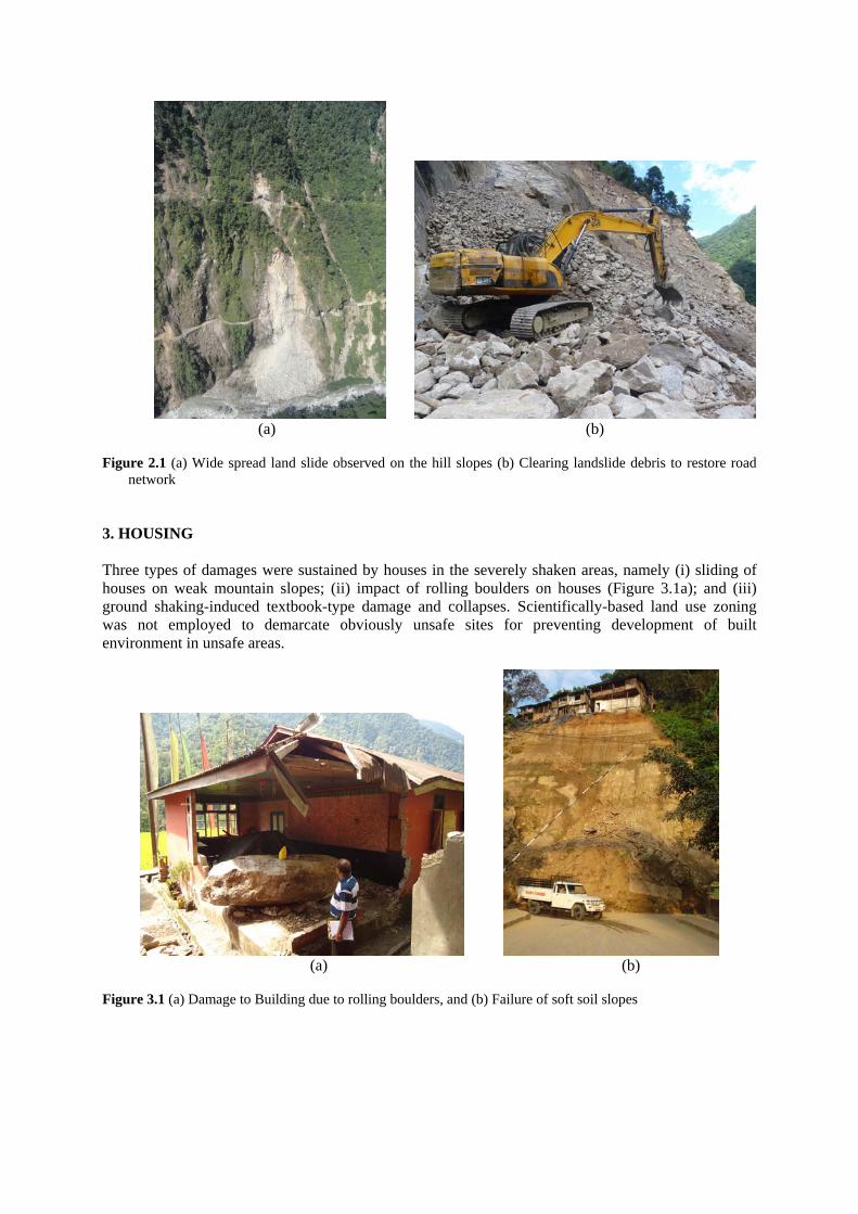
Figure 2.1 (a) Wide spread land slide observed on the hill slopes (b) Clearing landslide debris to restore road
network 3. HOUSING Three types of damages were sustained by houses in the severely shaken areas, namely (i) sliding of houses on weak mountain slopes; (ii) impact of rolling boulders on houses (Figure 3.1a); and (iii) ground shaking-induced textbook-type damage and collapses. Scientifically-based land use zoning was not employed to demarcate obviously unsafe sites for preventing development of built environment in unsafe areas.
(a) (b)
Figure 3.1 (a) Damage to Building due to rolling boulders, and (b) Failure of soft soil slopes

3.1. Buildings on Soft Soil Slopes Many instances are observed of creeping of soil under buildings rested on hill slopes, which are largely made up of metamorphic and sedimentary rocks covered with soft soil (Figure 3.1b). In areas of proximity to tunnelling works of hydro-power projects, local people ascribed such creeping to vibrations arising from frequent blasting performed for tunnelling. But, the earthquake provided higher levels of ground shaking that resulted in a number of landslides. Detailed analyses were not carried out to identify stable slopes and thereby determine safety of buildings built on hill slopes, especially in urban areas. Thus, indiscriminate construction was allowed irrespective of the building typology (without earthquake resistant features) and parameters like (i) material of the underlying soil and/or rock, (ii) slope of the hills, (iii) seismic hazard prevalent at this site, and (iv) moisture level in the soil. 3.2. Traditional Housing Traditional housing typology in Sikkim is the Assam-type or Ekra construction. It consists of a wood frame infilled with cross-woven wood matting plastered on both sides with mud or fine river sand in earlier times and by cement mortar in recent times. Another variation to this is the use of wood planks in constructions by the rich, in place of the mats. When made on flat ground, it rests on a relatively shallow and uniform masonry plinth (made of stone and mud mortar), and when made along hill slopes, it rests on a tapered stone plinth. Four varieties of stone masonry plinths are observed in Sikkim – random rubble masonry (RRM) with and without mud mortar, dry dressed stone masonry, dressed stone masonry, and dressed stone masonry with pointing. In recent times, the plinth also is being constructed in RC. During the earthquake, large stock of this typology of housing was shaken to different intensities across Sikkim. With the exception of distress in few stone masonry plinths (especially RRM plinths without any mortar), this typology has performed exceptionally well (Figure 3.2a). In instances, where the wood matting was replaced by clay-brick masonry infill walls in cement mortar, significant damage was sustained in them, including out-of-plane collapse. Good performance of this typology of housing in contrast to poor performance of the recently adopted (but aggressively built and desired) RC frame buildings with URM infill masonry re-iterates that this typology should be continued in the Himalayan region. But, Government of Sikkim notified this typology to be informal (kachcha) and just did the opposite. 3.3. Masonry Buildings Traditional construction of the region is of Ekra-type, but abundance of soft and hard stone along the hills of Sikkim has offered another dominant typology – Stone Masonry Construction. This has been patronised largely in the constructions of Military Engineer Services and Government of Sikkim. This typology is characterised by its thick walls in random rubble stone masonry and lack of any earthquake-resistant features, despite these constructions being in high seismic region of India – no bands, no through stones, and no vertical reinforcements at corners and around openings (Figure 3.2b). Many government schools and primary health centres were constructed in URM. Falling stones and out-of-plane collapse of walls are potential threats to people living in these constructions.

(a) (b)
Figure 3.2 (a) Traditional Ekra Construction (b) Masonry Building
3.4. Reinforced Concrete Buildings The following are some observations of RC buildings in Sikkim: (a) Design: Most buildings are not designed, but simply built without any engineering input in seismic zone IV (zone V is the worst as per Indian seismic code). This makes them vulnerable under earthquake effects (Figure 3.3a). No RC building in Sikkim has been seen to adopt structural walls; (b) Construction: Buildings are being constructed by poor construction methods and standards, which violate specifications laid down in prevalent Indian Standards. No quality control and quality assurance procedures are in place to ensure good and durable construction; and (c) Maintenance: Maintenance is absent in almost all buildings, irrespective of whether it is a government or private building. Fractured drains/pipes of the open drainage-cum-sewage system are major contributors to sustained moisture in buildings beyond excessive water directly from rains. 3.5. Heritage Structures Sikkim has large number of Buddhist monasteries, many of which were built in 16th century AD with random rubble masonry (RRM) walls and timber floor slabs and roofs. Some structures have masonry walls with timber framework. Monasteries constructed in the recent decades are in RC with infill masonry panels. Structural repair works in the recent years introduced RC elements (columns, beams and slabs) in these heritage masonry structures. Most interventions were adhoc and non-engineered. Some monasteries were retrofitted after the 2006 Sikkim earthquake (e.g., Enchey Monastery, Gangtok), but suffered damage during this earthquake. Extensive damage to these monasteries was observed, with partial to near-total collapse in several structures (Figure 3.3b). Typical seismic damage observed includes: (a) Out-of-plane bulging or collapse of RRM walls; (b) Sliding of timber roof relative to the masonry walls; (c) Out-of-plane collapse of orthogonal corners of perimeter RRM masonry walls; and (d) Shear failure of interior RC columns.

(a) (b)
Figure 3.3 (a) Failure of RC Building (b) Heritage Structure
3.6. Non-Structural Elements In the severely shaken areas, building finishes, contents and services (together called Non-Structural Elements) were severely affected. The holy scriptures of Buddhist culture were dislodged in monasteries. Ancient oil paintings on stone walls were lost by the cracking of the walls during earthquakes. In another monastery, glass windows were broken by the lateral shaking of the building. False ceilings were damaged in taller office, institutional and industrial buildings. In instances, HDP water tanks were dislodged. Electrical wiring and devices in housing was displaced owing to cracking in the masonry infill walls. In some school buildings, glass windows were broken by lateral shaking of the buildings. In a bank building, items toppled, e.g., book racks, record racks, and computer system monitors on table top. In some instances, chimneys on roofs cracked. 4. CRITICAL AND LIFELINE STRUCTURES A major hindrance for continuance of critical and lifeline facilities was absence of staff members manning these places, who had left office to secure their families to safer locations after the earthquake. Also, impending Hindu and Buddhist festivals prompted many to go on extended leave. 4.1. Bridges Bridges in the region were built with wood, concrete, and steel, and of common typologies, like deck slab and girder, arch, truss, suspension and cable-stayed bridges. Most bridges in the region indicate exceptionally poor maintenance; corrosion was noticed in RC elements, in particular. In general, bridges suffered relatively lesser amount of damage in comparison to buildings. Damage was of varying nature, including loosening of abutments, pounding of spans, falling of lamp posts on deck, minor distress to anchor blocks of suspension bridges, distress to masonry piers and abutments, pounding (deck-to-deck and deck-to-abutment) and residual displacement in deck/abutment. But, an important effect was due to landslides and rolling boulders and flash floods. Two bridges in the affected area were reportedly washed away during landslide and subsequent flash floods.

4.2. Water Supply and Distribution System Water supply was disrupted to Gangtok city due to earthquake-induced landslides that ruptured water mains coming from a reservoir over 20 km north of Gangtok. Partial water supply was restored in 5 days time, but full supply was not available even after 10 days of the earthquake. Underground water pipelines ruptured at several locations in Gangtok; one of the main reasons why supply could not be restored through pipes. Similarly, water supply was disrupted for over 10 days in other places in North Sikkim district (e.g., Chungthang). Drinking water was being supplied by tankers in some towns (e.g., Chungthan) by the Indian Army. 4.3. Hydro-Power Projects The state of Sikkim has taken to developing hydro-power in a big way. Over 30 hydro-power projects have been approved over the last three years, and many are underway. These projects are distributed along the river Teesta and its tributaries in the state of Sikkim. The constructions include (i) building new dams to bund the water and use the head for power generation, and (ii) channel the water through tunnels drilled through the mountains at locations where the river bends to generate adequate head for effective power generation. There is no public information available on the damage sustained by these projects during the earthquake. Since many of these projects are under construction, access to them is restricted. Damages include: (a) a landslide adjoining on workers camp at one of the projects resulted in loss of lives; (b) damage sustained by wing walls and spillways due to rolling boulders and sliding debris of landslides; (c) blocking the entrance of tunnels by rolling boulders and sliding debris; and (d) accumulation of sliding debris on the roof of structure. 4.4. Roads The general geology and topology of the region suggests that almost all roads are made on cuts on steep hill slopes covered with relatively soft soil. During the earthquake, the hills were shaken and loosened. Immediate rainfall reduced the friction and hastened landslides responsible for slip of stones and boulders atop these steep hill slopes. Notwithstanding earthquake shaking, significant creeping of slopes is noticed even during rainy seasons. General, movement of hill slopes is noticed in many locations. Sliding was noticed of longitudinal segments of the roads at many locations. Further, landslides also blocked a number of roads at many locations. Roads are critical for the normal working of communities and are critically needed immediately after any earthquake shaking. Many upper reaches of Sikkim Himalayas remained unconnected for about two weeks owing to landslides washing away the hill roads. 4.5. Electrical Power There was a power surge during the earthquake in the meisoseismal area. Many appliances were damaged by this power surge. Also, power outage occurred in the areas with strong earthquake shaking. High tension towers and lines were damaged due to falling debris from landslides. Even local distribution poles were dislodged due to ground deformation generated by soft soil slope failure (Figure 4.1a). Restoration of power was not done in locations worst hit, e.g., Chungthang, even 12 days after the earthquake. Due to unavailability of power, services dependent on the same were greatly affected, e.g., water supply and phone network. This earthquake re-iterates that earthquake menace is not just a concern for architects, engineers and governments to worry about; electrical engineers and mechanical engineers also need to address some attention to this aspect.

4.6. Communication System Communications failed to towns, like Chungthan, Lachen and Lachung, due to effects of earthquake shaking, like (a) general power failure to the communication system, and (b) severe damage to RC buildings carrying the communication towers on their roof (the staff feared to enter these buildings as many of them were damaged) (Figure 4.1b). Absence of staff, non-availability of power and non-availability of linking communication towers were prime reasons for delay in restoring communication facilities. No emergency plan was available to ensure continuity of communication in all areas. Backup power systems were not available at critical communication facilities. Also, communication antennas were hosted on towers or on antennas that are rested on buildings that are not earthquake-resistant.
(a) (b)
Figure 4.1 (a) Electrical Power, and (b) Communication System 4.7. Sewage Services Urban and semi-urban areas in the state of Sikkim have open and mixed drainage-cum-sewage system – both drainage and sewage are transported together to the treatment plants. Even during normal conditions, there are ruptures in the drainage gutters laid along the ground, owing to slow creeping of the underlying soft soil conditions. During this earthquake, many brittle sewage pipes stapled to URM infill walls ruptured and spilled the sewage within the premises of buildings, when URM infill walls were damaged during strong shaking. In rural areas, septic tanks are used in the neighbourhood of the house. 4.8. Schools There are a number of schools in the areas affected by the earthquake. Older schools were made of traditional Ekra construction, while recent ones (including extensions and replacements structures) of URM and RC. In a single instance, collapse was observed of the intermediate storey of a school building. Also, a recently constructed school extension (with RC frame and roof, and without masonry infill walls) suffered critical damage to RC columns and beams; poor design and quality of construction seem to be the main causes for this damage. Consistent with the general performance of buildings in the affected area, the former (i.e., Ekra construction) did relatively better than the latter

(i.e., RC Buildings). However, damage to RC school buildings has deprived the government of safe havens for running post-earthquake relief camps and emergency services. Damage assessment of school buildings was irrational, with buildings of all grades of damage declared to be unsafe for use and declared to require rebuilding. No technical strategies were undertaken to examine schools buildings for potential damage and identify unsafe ones. Those school buildings in the state of Sikkim that were not affected by this earthquake, but have a construction typology that is observed in this earthquake to be vulnerable, were not examined for their structural safety in upcoming earthquakes. 4.9. Hospitals Regional government hospitals are located in bigger towns, like Gangtok and Geizing, and smaller primary health canters spread out throughout the state of Sikkim. These constructions ranged from traditional Ekra-type, URM, to RC structures. Most of these structures suffered (a) pounding damage at construction joints, and (b) frame-infill separation, crackling of plaster and diagonal cracking of infill walls in RC frame buildings. In one instance, government engineers declared a hospital building unsafe, just based on the damage to the independent porch structure, when the rest of the 5-storey RC building did not demonstrate any distress; the hospital unit was moved urgently out of the building, and in the process a number of valuable documents may have been lost, as many papers were found to be strewn all over the building. In another instance, a primary health centre was abandoned; it was made of RC frame with RC floor in first storey and a light roof in the second, even though it suffered only frame-infill separation, cracking of plaster, and diagonal cracking of URM infill walls. Doctors and staff were operating from neighbouring single storey Ekra building. In addition, the road leading to this health centre was in utmost neglect and not working in normal conditions. Post-earthquake damage assessment teams that are capable of determining the safety of buildings were NOT commissioned in the state of Sikkim. This would have saved some hospital buildings that are required to be operational and in working condition, but were declared unsafe by novices in the subject. 5. TECHNO-LEGAL REGIME FOR CONSTRUCTION The critical issues related to regulatory framework are: (a) Design: There are only 2 structural engineers, and about 30-40 architects and graduate civil engineers in the entire state of Sikkim; (b) Construction: There are no set standards in the municipal bye-laws for construction of buildings. Also, there is no adherence of any techno-legal regime; and (c) Maintenance: There are no set procedures in the municipal bye-laws for maintenance of buildings. 6. LESSONS LEARNED This earthquake may not have offered any NEW lessons for the country, but has re-iterated all lessons learned in past earthquakes in the country. But, for sure, Government of Sikkim has a timely opportunity to build systems to ensure that all new constructions are earthquake-resistant and existing vulnerable ones retrofitted. Pointed lessons to be internalised by the state of Sikkim include:
a. Landslide potential in the State was not undertaken, especially along critical roads and in areas with (i) known potential for sliding, rolling, shooting and subsidence, (ii) large population and (iii) built environment. Redundant road networks were absent in affected areas.
b. A professional and regulated environment for design and construction of new RC buildings is absent in the state that was required to have its built environment earthquake-resistant.
c. Manuals of good construction practices are unavailable on traditional ekra construction. Currently, this typology of construction is declared as informal housing by the Government of Sikkim, which prohibits issuance of bank loans, etc.
d. Critical, lifeline and governance structures, that are currently standing, are most vulberable, because of the choice of construction typology with no earthquake-resistant design and construction features.
e. Professional architects and engineers in the state do not seem to have the technical knowledge

on the methodology for assessment of damaged structures. f. Historical masonry structures in Sikkim were affected the most, amongst all constructions. g. Some government buildings and hospitals in the state sustained nominal damage and could
have been used after the earthquake. But, these were “declared” unsafe and ordered to be demolished without seeking professional inputs of engineers conversant with methodology of assessing safety of such earthquake damaged structures. This caused severe disruption to relief operations, governance continuity and medical service continuity through these buildings. Post-Earthquake Damage Assessment Teams were not deployed, which were trained to have capabilities to provide sound judgement on usability of structures damaged during earthquake shaking.
h. This moderate earthquake re-iterated the need to address safety of non-structural elements (i.e., building contents, facades and services) formally while designing buildings. Many losses were incurred in hospitals, office buildings, monasteries, and residential buildings.
i. Communication to meisoseismal area was cut-off for more than 12 days after the earthquake. j. Landslide damage to water mains prevented supply of water from large distances to urban
areas and towns. k. Bridges were affected in the areas in and adjoining the meisoseismal region. l. Strong ground motions recorded in the region suggests that PGA values were in the range of
0.23g-0.55g. The construction typologies without earthquake resistant features clearly were not capable of resisting this level of shaking.
m. Engineering and Architecture Colleges in the state do not have earthquake-resistant design and construction in their curriculum.
n. Roads were affected during this earthquake by the longitudinal cracking of slopes, landslides and rolling boulders.
This 2011 Sikkim Earthquake was an earthquake that caused moderate intensity of shaking. But, the losses incurred were disproportionately higher than that expected for this level of shaking. The lessons learned again can have large consequences, if they are capitalised on, unlike the opportunity lost after the 2006 earthquake in the same area. While the common man will remember this earthquake as one that caused landslides, this must be seen as a small warning before the big one strikes. AKCNOWLEDGEMENT The authors are grateful to National Disaster Management Authority, Government of India, New Delhi, and Building Materials and Technology Promotion Council, New Delhi, for their generous support for undertaking the above field investigations. REFERENCES Murty, C.V.R., Sheth, A.R. and Rai,D.C. (2011). M 6.9 Sikkim Earthquake of September 19, 2011. EERI
Newsletter. 45:11, 6-7. Murty, C.V.R., Raghukanth, S.T.G., Menon, A., Goswami, R., Vijayanarayanan, A.R., Gandhi, S.R.,
Satyanarayana, K.N., Sheth, A.R., Rai, D.C., Mondal, G., Singhal, V., Parool, N., Pradhan, T., Jaiswal, A., Kaushik, H.B., Dasgupta, K., Chaurasia, A., Bhushan, S., Roy, D. and Pradeep Kumar, R. (2012). The Mw 6.9 Sikkim-Nepal Border Earthquake of September 18, 2011. EERI Newsletter, EERI Special Earthquake Report,. February 2012, 1-14.