shinnecock bay designated: march 15, 1987 date …€¦ · page 1 of 7 attachment b: coastal fish...
TRANSCRIPT

Page 1 of 7
Attachment B:
COASTAL FISH & WILDLIFE HABITAT ASSESSMENT FORM
Name of Area: Shinnecock Bay Designated: March 15, 1987Date Revised: December 15, 2008County: Suffolk Town(s): Brookhaven, Southampton 7½' Quadrangle(s): Mattituck, Quogue, Shinnecock Inlet, Southampton, NY
Assessment Criteria
Ecosystem Rarity (ER)–the uniqueness of the plant and animal community in the areaand the physical, structural, and chemical features supporting this community.
ER assessment: Large, protected, shallow, coastal bay; rare in New York State.
Species Vulnerability (SV) – the degree of vulnerability throughout its range in NewYork State of a species residing in the ecosystem or utilizing the ecosystem for itssurvival. (E = Endangered, T = Threatened, SC = Special concern)
SV assessment: Osprey (SC) nesting grounds.
Human Use (HU) – the conduct of significant, demonstrable, commercial, recreational, or educational wildlife-related human uses, either consumptive or non-consumptive, inthe area or directly dependent upon the area.
HU assessment: Recreational fishing and shellfishing in the area are significant to residentsfrom throughout Long Island. Commercial fishing in the area of regionalsignificance.
Population Level (PL) – the concentration of a species in the area during its normal,recurring period of occurrence, regardless of the length of that period of occurrence.
PL assessment: Concentrations of wintering waterfowl and harbor seals are of statewidesignificance.
Replaceability (R) – ability to replace the area, either on or off site, with an equivalentreplacement for the same fish and wildlife and uses of those same fish and wildlife, forthe same users of those fish and wildlife.
R assessment: Irreplaceable.
Score
64
16
9
16
1.2
Habitat Index: ( ER + SV + HU + PL) = 105 Significance: (HI x R) = 126

Page 2 of 7
NEW YORK STATESIGNIFICANT COASTAL FISH AND WILDLIFE HABITAT
NARRATIVE
SHINNECOCK BAY
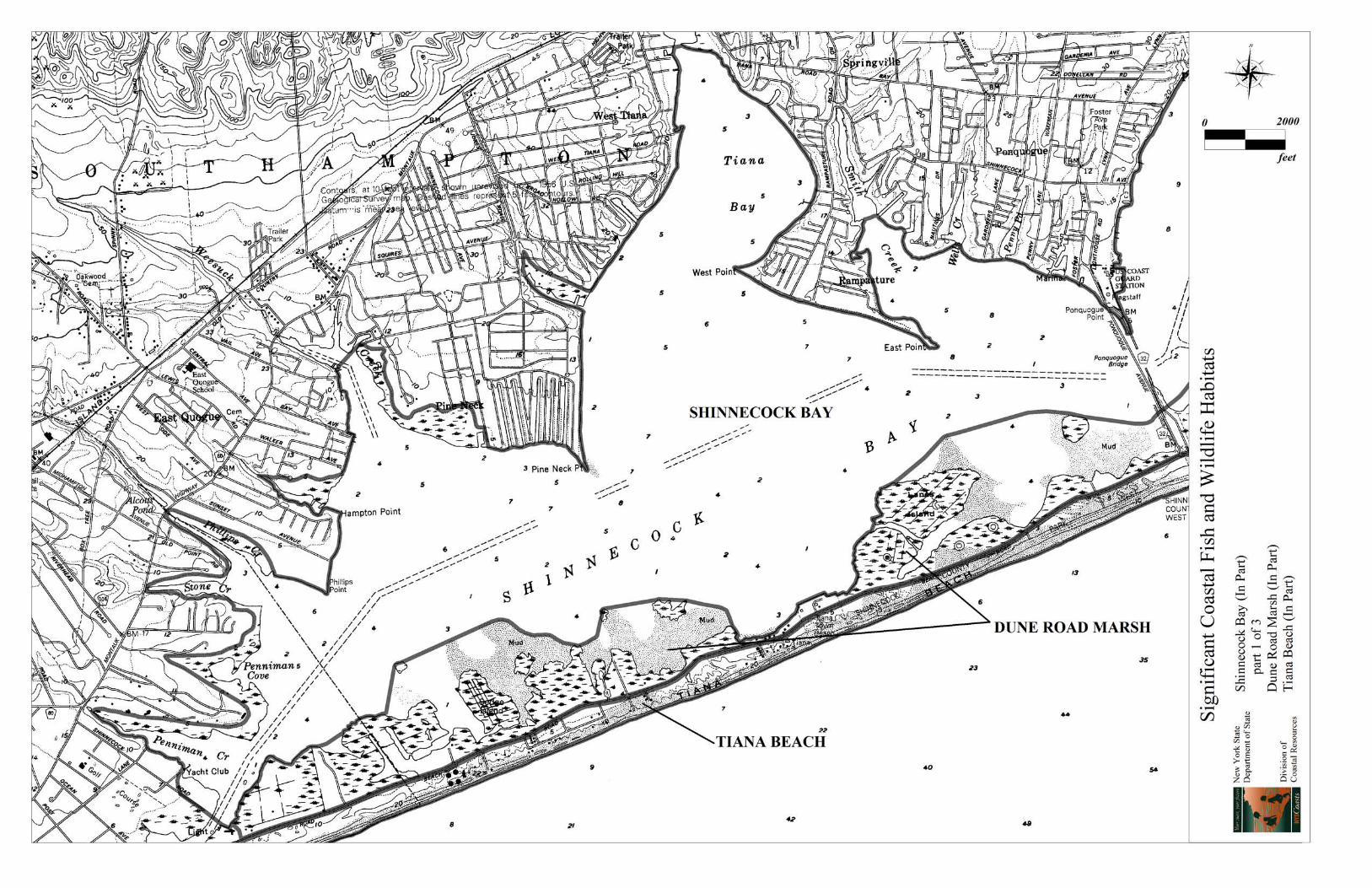
LOCATION AND DESCRIPTION OF HABITAT: Shinnecock Bay is located along the south shore of Long Island, between the Villages of Quogue andSouthampton, in the Town of Southampton, Suffolk County (7.5' Quadrangles: Mattituck, N.Y.; Quogue,N.Y.; Shinnecock Inlet, N.Y.; and Southampton, N.Y.). This approximate 9,000 acre area is generallydefined by the mean high water elevation on the west, north, and east sides, and by the bayside edge ofthe salt marshes and mudflats along the south shore. The fish and wildlife habitat is the entire bay, whichincludes Tiana Bay, Heady Creek, Halsey Neck Pond and Shinnecock Inlet. This area contains extensiveareas of open water and limited amounts of undeveloped salt marsh and mud flats. The bay is borderedby high density residential development and small craft harbor facilities on the north and west sides. TheShinnecock Indian Reservation located on the east side of Shinnecock Bay between Heady Creek andOld Fort Pond and the barrier beaches to the south are less intensively developed than the surroundingareas.
Water depths throughout Shinnecock Bay are generally less than 10 feet below mean low water. Westernportions of the bay are primarily shoal and shallow (6 feet or less), while eastern portions of the bay aredeeper (10 feet or more). Shinnecock Inlet, a shallow water area in the bay, connects Shinnecock Bay tothe Atlantic Ocean, and was formed by a breach through the barrier beach during the hurricane of 1938. It was stabilized by stone jetties between 1947 and 1954. The inlet is affected by substantial littoral drift,much of which is deposited in a sand bar seaward of the inlet and in a sand shoal in the bay. Tidalfluctuations in Shinnecock Bay average approximately 0.7 to 2.28 feet in specific locations, dependingon the condition of the inlet. Shinnecock Bay is connected to Moriches Bay (to the west) via the QuogueCanal, and to Great Peconic Bay via the Shinnecock Canal. The Shinnecock Canal is controlled todischarge only Great Peconic Bay waters into Shinnecock Bay. There has been relatively littledisturbance of the bottom substrate in Shinnecock Bay. Submerged aquatic vegetation beds are presentin shallow, quiet waters below the spring low tide level in the bay. Sediments in the bay are composedprimarily of sand and gravel from glacial outwash and marine sources.
Several of the wetlands within Shinnecock Bay are recognized by the U.S. Fish and Wildlife Service aspriority wetlands under the Federal Emergency Wetlands Resources Act of 1986. Four sites alongShinnecock Bay have been identified as focus areas for acquisition and/or restoration by the AtlanticCoast Joint Venture of the North American Waterfowl Management Plan. There are highly productiveestuarine intertidal systems in the bay including salt marshes and mudflats which fringe the barrierislands and creek outlets. Characteristic communities of the estuarine intertidal subsystem in ShinnecockBay transition from low to high salt marshes, to salt pannes, to salt shrublands dominated by smoothcordgrass (Spartina alterniflora), common glasswort (Salicornia europea), salt hay grass (Spartinapatens), spike grass (Distichlis spicata), perennial saltmarsh aster (Aster tenuifolius), black grass (Juncusgerardii), switchgrass (Panicum virgatum), and shrub dominance by groundsel tree (Baccharishalimifolia) and high-tide bush (Iva frutescens).

Page 3 of 7
FISH AND WILDLIFE VALUES:
Shinnecock Bay is one of the most important waterfowl wintering areas (November - March) on LongIsland. Mid-winter aerial surveys of waterfowl abundance for the 13 year period from 1986 to 1998(excluding 1997) indicate average concentrations of over 1,580 birds in the bay each year (3,567 in peakyear). Observed diving ducks, concentrated in the northern and eastern parts of Shinnecock Bay, includean annual average of 444 (common, red-breasted, and/or hooded) merganser (1,190 in peak year), 399(greater and/or lesser) scaup (1,390 in peak year), 88 common goldeneye (258 in peak year), along withlesser numbers of canvasback, bufflehead, long-tailed duck, and scoter. Observed dabbling ducks,concentrated along the backside of Southampton Beach, include an annual average of 390 Americanblack duck (640 in peak year), along with lesser numbers of mallard and American wigeon. Canadagoose and brant were also observed in the bay during the survey period. Based on the mid-winter aerialsurveys, Shinnecock Bay supports wintering waterfowl concentrations of statewide significance. Waterfowl use of the bay during winter is influenced in part by the extent of ice cover each year. Concentrations of waterfowl also occur in Shinnecock Bay during spring and fall migrations (March -April and October - November, respectively). Waterfowl hunting opportunities are limited in ShinnecockBay due to the lack of extensive marshlands within the habitat and therefore are only of county-levelsignificance. The Town of Southampton provides and requires an escort for any hunting activity in thearea. Shinnecock Bay is also host to breeding osprey (SC) Cooper’s hawk (SC), and red-tailed hawk. For the six year period 1998-2003 an annual average of 4 breeding pairs of osprey (SC) have nestedalong the shores of Shinnecock Bay.
Shinnecock Bay is one of three major protected, shallow, coastal bay areas on the south shore of LongIsland, and represents one of the largest estuarine ecosystems in New York State. This highly productivebay is important to a variety of fish and wildlife species throughout the year. A survey completed in 1997found 97 species of special emphasis in the Shinnecock Bay Complex, including 42 species of fish and37 species of birds. Much of the productivity of marine finfish and shellfish is directly attributable tothe salt marshes and tidal flats which border the bay. Shinnecock Bay serves as a nursery and feedingarea (April - November, generally) for bluefish, winter flounder, summer flounder, scup, weakfish,tomcod, and blue crab. Forage fish species are also present, including Atlantic silversides, Atlanticmenhaden, striped killifish, pipefish, American sandlance (the primary food source of the endangeredroseate tern), American eel, alewife, blueback herring, Atlantic sturgeon, and sticklebacks. Halsey LanePond, a freshwater pond draining into Heady Creek, contains a significant population (at least 1,000individuals) of alewife. A total of 51 fish species were collected during an intensive survey of the bay in1981 and more recent studies, undertaken by the Marine Science Station of Long Island University,captured and identified 141 species marine life. As a result of the abundant fishery resources in the bay,Shinnecock Bay receives heavy recreational and commercial fishing pressure, of regional significance. Shinnecock Inlet is also an especially significant component of Shinnecock Bay as a corridor for fishmigrations, as a source for the exchange and circulation of bay waters, and as an area where foraging bymany fish and wildlife species is concentrated.
Wildlife species which feed extensively on fishery resources near the inlet and on the islands within thebay include gray seal and harbor seal. Exposed sand shoals near the inlet provide an important hauloutarea which seals use for resting and sunning. This location is one of about five major haulouts aroundLong Island, serving as a focal point for seals feeding in the bay. From December through early May,concentrations of harbor seals (approximately 30-40 individuals) occur in Shinnecock Bay. Other marinemammals using the habitat area include mink whale and bottle-nosed dolphin. In the summer monthsjuvenile loggerhead sea turtles (T) and green sea turtles (T) come to feed in Shinnecock Bay.

Page 4 of 7
Shinnecock Bay is also inhabited by hard clams, soft clams, bay scallops, and bank mussels. Most of thebay waters are certified for commercial shellfishing, aside from approximately 193 acres of permanentlyclosed and 88 acres of seasonally closed waters. Shellfishing is restricted to town residents in town-owned waters. Landings data for Shinnecock Bay and Quantuck Bay indicate, for the 5 year period1996-2000, an average harvest of 17,374 hard clam, 3,620 soft clam, 1,401 oyster, 3,353 mussel, 735conch, 324 bay scallop, and 12,071 razor clam bushels. Moreover, landings numbers reported from1996-2000 for razor clam and mussels in Shinnecock Bay account for 6% and 56% of average landingsdata for New York, respectively. Shellfish harvests from the area are of regional significance.
Shinnecock Bay encompasses 969 acres of submerged rooted aquatic vegetation beds, accounting forapproximately 11% of the entire habitat area. These beds are dominated primarily by eelgrass (Zosteramarina) with some wigeon grass (Ruppia maritima). Submerged aquatic vegetation beds providespawning and foraging habitat for an array of mollusks, crustaceans, juvenile fish, diving ducks, as wellas some terrestrial species. The distribution and abundance of benthic species in the bay's eelgrasscommunity is likely controlled by a number of factors that include eelgrass stem density, watertemperature and salinity, sediment type, predation, food supply, and human harvest.
IMPACT ASSESSMENT:
Any activity that would degrade water quality, increase turbidity, increase sedimentation, or alter flows,temperature, or water depths would affect the biological productivity of this area. All species would beadversely affected by water pollution, such as chemical contamination (including food chain effectsresulting from bioaccumulation), oil spills, excessive turbidity or sediment loading, non-point source run-off, waste disposal (including vessel wastes), and stormwater runoff. It is essential that high waterquality be maintained in the bay to protect the shellfishery. Efforts should be made to improve waterquality in the bay, including the reduction or elimination of discharges from vessels and upland sources,effective oil and toxic chemical spill prevention and control programs, upgrading of wastewater treatmentplants, enactment of pet waste ordinances to reduce coliform contributions to the bay, and theimplementation of erosion control and stormwater pollution prevention best management practices. Vegetated upland buffer zones (e.g. wetlands, dunes, and forested areas) should be protected orestablished to reduce non-point source pollution and sedimentation from upland sources.
Alteration of tidal patterns in Shinnecock Bay, by modification of inlet configurations or other means(e.g., sediment removal by dredging, channelization, bulkheading), would have negative impacts on thebiotic communities present. Elimination of salt marsh and intertidal areas, through loss of intertidalconnection, ditching, excavation, or filling, would result in a direct loss of a valuable habitat. No newboat channels should be excavated within the area. Dredging to maintain Shinnecock Inlet and otherexisting navigation channels in the bay should be scheduled in between September 15 and December 15to minimize adverse effects on aquatic organisms (including harbor seals). Unregulated dredged materialplacement in this area would be detrimental to the habitat, but such activities may be designed tomaintain or improve the habitat for certain species of wildlife.
Construction of shoreline structures, such as docks, piers, bulkheads, or revetments, in areas notpreviously disturbed by development (e.g., natural salt marsh, tidal flats, or shallows), would result in adirect loss of valuable habitat area. Restoration of previously connected portions of the habitat, includingthe removal of structures (e.g. bulkheads, groins, jetties) which disrupt natural sedimentation anddeposition patterns and physically alter the habitat may be beneficial. Maintenance of existing erosioncontrol structures which interfere with natural coastal process should be carefully evaluated for need and

Page 5 of 7
where possible, non-structural solutions should be utilized.
Unrestricted use of motorized vessels, including personal watercraft, in shallow waters can have adverseeffects on the benthic community, and on fish and wildlife populations through resuspension of seafloorsediments and through shoreline erosion which may reduce water clarity and increase sedimentation. Use of motorized vessels should be controlled (e.g., no wake zone, speed zones, zones of exclusion) inand adjacent to shallow waters and adjacent wetlands. Docks, piers, catwalks, or other structures may bedetrimental to submerged aquatic vegetation (SAV) beds through direct or indirect effects from shading,mooring chain scarring, and other associated human uses. Where environmental parameters areappropriate, opportunities for restoration of SAV beds may exist. Any restoration of SAV beds shouldutilize the best available science and implement proper monitoring protocols.
Thermal discharges, depending on time of year, may have variable effects on use of the area by marinespecies, such as sea turtles and overwintering waterfowl. Installation and operation of water intakescould have significant impact on juvenile (and adult, in some cases) fish concentrations, throughimpairment or entrainment. Activities that would enhance migratory, spawning, or nursery fish habitat,particularly where an area is essential to a species’ life cycle or helps to restore an historic speciespopulation would be beneficial. Where appropriate, hydrological modifications (e.g. dams, dikes,channelization, bulkheading, sedimentation, etc.) should be mitigated or removed, including the rejoiningof formerly connected tributaries, and the removal of obstructions or improvements to fish passage. Activities to protect or restore wetland habitat in Shinnecock Bay, consistent with best managementpractices, (including the restoration of historic tidal regime, planting of native vegetation, control ofinvasive species, etc.) may enhance habitat values for fish and wildlife species.
Any permanent alteration or human disturbance of the seal haulout area, or obstruction of seal migrationswould adversely affect this species. Significant underwater noise, from dredging or other underwateractivities, may also preclude harbor seals from using the area. HABITAT IMPAIRMENT TEST:
A habitat impairment test must be applied to any activity that is subject to consistency review underfederal and State laws, or under applicable local laws contained in an approved local waterfrontrevitalization program. If the proposed action is subject to consistency review, then the habitatprotection policy applies, whether the proposed action is to occur within or outside the designated area.
The specific habitat impairment test is as follows.
In order to protect and preserve a significant habitat, land and water uses or developmentshall not be undertaken if such actions would:
! destroy the habitat; or,
! significantly impair the viability of a habitat.
Habitat destruction is defined as the loss of fish or wildlife use through direct physical alteration,disturbance, or pollution of a designated area or through the indirect effects of these actions on adesignated area. Habitat destruction may be indicated by changes in vegetation, substrate, or hydrology,

Page 6 of 7
or increases in runoff, erosion, sedimentation, or pollutants.
Significant impairment is defined as reduction in vital resources (e.g., food, shelter, living space) orchange in environmental conditions (e.g., temperature, substrate, salinity) beyond the tolerance range ofan organism. Indicators of a significantly impaired habitat focus on ecological alterations and mayinclude but are not limited to reduced carrying capacity, changes in community structure (food chainrelationships, species diversity), reduced productivity and/or increased incidence of disease andmortality.
The tolerance range of an organism is not defined as the physiological range of conditions beyond whicha species will not survive at all, but as the ecological range of conditions that supports the speciespopulation or has the potential to support a restored population, where practical. Either the loss ofindividuals through an increase in emigration or an increase in death rate indicates that the tolerancerange of an organism has been exceeded. An abrupt increase in death rate may occur as anenvironmental factor falls beyond a tolerance limit (a range has both upper and lower limits). Manyenvironmental factors, however, do not have a sharply defined tolerance limit, but produce increasingemigration or death rates with increasing departure from conditions that are optimal for the species.
The range of parameters which should be considered in applying the habitat impairment test include butare not limited to the following:
1. physical parameters such as living space, circulation, flushing rates, tidal amplitude, turbidity,water temperature, depth (including loss of littoral zone), morphology, substrate type, vegetation,structure, erosion and sedimentation rates;
2. biological parameters such as community structure, food chain relationships, species diversity,predator/prey relationships, population size, mortality rates, reproductive rates, meristic features,behavioral patterns and migratory patterns; and,
3. chemical parameters such as dissolved oxygen, carbon dioxide, acidity, dissolved solids,nutrients, organics, salinity, and pollutants (heavy metals, toxics and hazardous materials).
Although not comprehensive, examples of generic activities and impacts which could destroy or significantlyimpair the habitat are listed in the Impact Assessment section to assist in applying the habitat impairment testto a proposed activity.

Page 7 of 7
KNOWLEDGEABLE CONTACTS: New York State Department of State
Division of Coastal Resources Habitat Unit 99 Washington Avenue Albany, NY 12231 Phone: (518) 474-6000 NYSDEC - Region 1 State University of New York, Building 40 Stony Brook, NY 11790 Phone: (631) 444-0204
NYSDEC Bureau of Marine Resources205 N. Belle Meade Road, Suite # 1East Setauket, NY 11733Phone: (631) 444-0430
NY Natural Heritage Program625 Broadway, 5 Floorth
Albany, NY 12233Phone: (518) 402-8935
Department of Land ManagementTown of Southampton116 Hampton RoadSouthampton, NY 11968Phone: (631) 287-5710