shelter banjarmasin master class_do_final
TRANSCRIPT


Urban Planning & Design MasterclassBanjarmasin 2015
“URBAN WATER CHALLENGES IN DEVELOPING COUNTRIES”Angel David Osorio
Chartered Civil Engineer (MICE)
BSc in Agricultural Engineering, MSc in Hydrologic Engineering, BSc in Economics
Drainage Design Manager – ARCADIS/HYDER CONSULTING (Philippines)Drainage Design Manager – ARCADIS/HYDER CONSULTING (Philippines)

Urban Development: Key IssuesSource: Asian Development Bank - Urban Development: Issues & Challenges
• Rapid urban population growth: 2008, > half world population lived in urban areas
(3.3 billion people) . 2030, expected almost 5 billion. Most of this growth will be in
developing countries. Urban population of Africa and Asia expected to double between
2000 and 2030 (UNFPA, 2007).
• High urban poverty level: Almost 25% of Asia's urban population is poor.
• Inadequate basic services: Large number of Asian cities cannot adequately provide
urban basic services. < Half of the cities population is covered by water supply. A
number of cities do not have efficient systems of solid waste collection. Majority of the
cities do not have sewerage system connections, and sanitary landfill facilities.
• Environmental degradation: With an increasing population density, especially in slums
areas, environmental and health problems are rising as well as concerns in managing
the consumption of non-renewable resources.
http://www.adb.org/themes/urban-development/issues
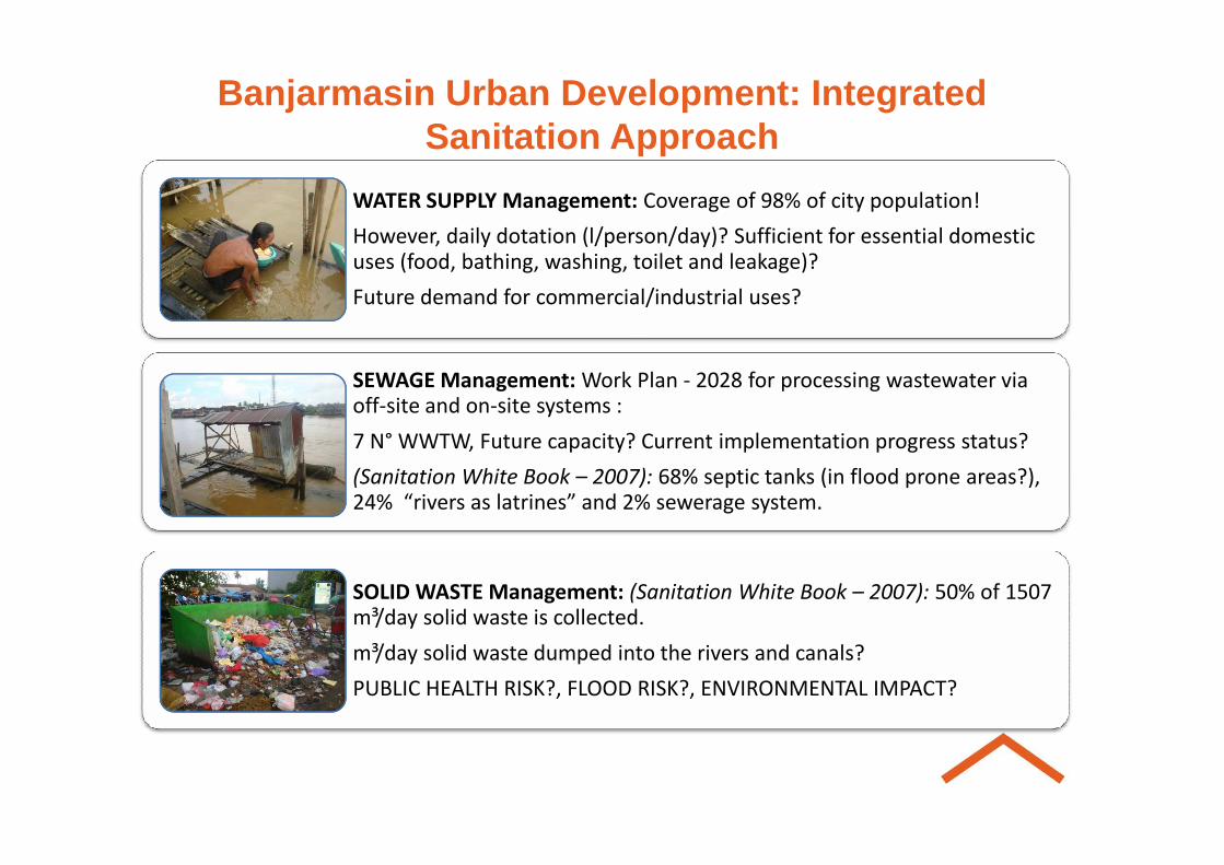
Banjarmasin Urban Development: Integrated Sanitation Approach
WATER SUPPLY Management: Coverage of 98% of city population!
However, daily dotation (l/person/day)? Sufficient for essential domestic uses (food, bathing, washing, toilet and leakage)?
Future demand for commercial/industrial uses?
SEWAGE Management: Work Plan - 2028 for processing wastewater via off-site and on-site systems :
7 N° WWTW, Future capacity? Current implementation progress status?7 N° WWTW, Future capacity? Current implementation progress status?
(Sanitation White Book – 2007): 68% septic tanks (in flood prone areas?), 24% “rivers as latrines” and 2% sewerage system.
SOLID WASTE Management: (Sanitation White Book – 2007): 50% of 1507 m³/day solid waste is collected.
m³/day solid waste dumped into the rivers and canals?
PUBLIC HEALTH RISK?, FLOOD RISK?, ENVIRONMENTAL IMPACT?

Banjarmasin Urban Development: Integrated Sanitation Approach
SURFACE WATER & FLOOD RISK MANAGEMENT
HYGIENE & ENVIRONMENTAL EDUCATIONHYGIENE & ENVIRONMENTAL EDUCATION
ORGANIZATIONAL & INSTITUTIONAL EMPOWERMENT

DRAINAGE PROBLEMS IN BANJARMASIN?
How to build up based on “robust and solid foundations”?
Banjarmasin population already demonstrated a high knowledge and expertise on building on “solid foundations”
How to build up a Drainage Management Strategy on “solid foundations” for the benefit of Banjarmasin population? → FLOOD RISK BASED APPROACH
RISK = PROBABILITY x CONSEQUENCES

Integrated Flood Risk & Drainage Management Plan for Sustainable DevelopmentWhy IFR&DM Plan?
High impact in public health and in current process of degradation of local environment
Basic planning methodology for sustainable and Basic planning methodology for sustainable and achievable economic development (“Future Growth Center” – Medium Term Plan Indonesia 2014-2019”)
Basic planning tool for robust and efficient “make-decision” process at medium-long term – VALUE FOR MONEY!

IFR&DM PlanMain Flood Risk and Drainage Problems in Banjarmasi n?
1. Insufficient drainage capacity for dealing with E xisting Flood Risk :
High urban flood risk from insufficient conveyance and
storage capacity of existing drainage canals system
(dumped solid waste, siltation, invasion and reduction of
main rivers and canals) → Short-term action
High urban flood risk from insufficient protection against sea and rivers levels affected by Ndal movements → Medium-long term solution → “IFR&DM Plan ”

IFR&DM Plan2. Insufficient Drainage Capacity and Flood Protecti on for dealing with
potential increased Future Flood Risk from several risk sources:
Climate Change Impacts (Increasing sea levels and probability storm events of high intensity) → Medium-long term solution → IFR&DMP
Increased Population (people potentially affected by Increased Population (people potentially affected by floods, increasing urban runoff and solid waste generation) → Medium-long term solution → IFR&DMP
Increased Level of Development – Industrialization (Higher Costs from flooding, Increasing deforestation process, sedimentation in rivers and main channels, natural runoff) → Medium-long term solution → IFR&DMP
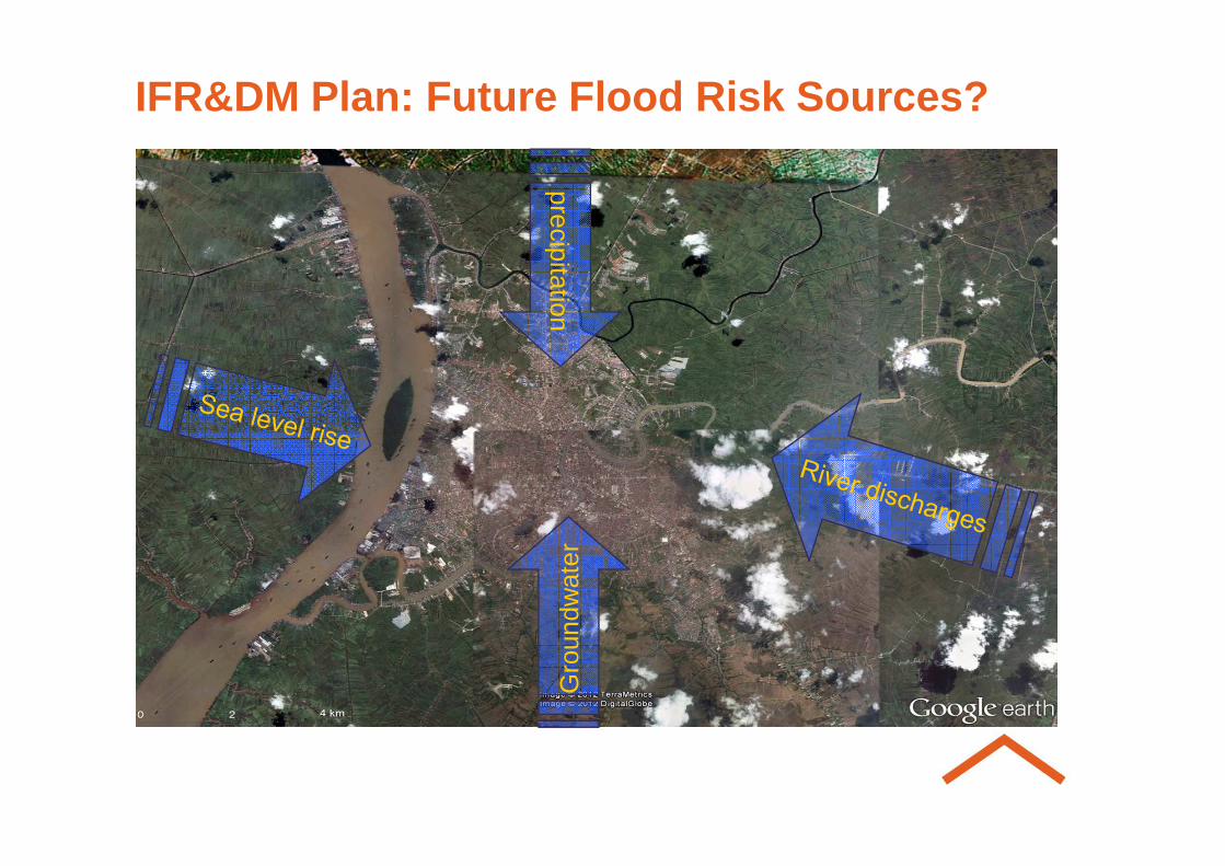
precipitation
IFR&DM Plan: Future Flood Risk Sources?
Gro
undw
ater

“Planning Layer” approach:
“First plan water, then think urban development” “Water layer” guides planning approach for other urban components (Transport, Housing, Industrial, etc.)
IFR&DM Plan: Future Urban Development based on Water and Natural resources
Public
Housing
Industrial, etc.)
Natural dimension of water resources determine future developent
Land Use is determined based on water requirements (floodplain) and natural resources (ecosystems)
Water
Road
Public

IFR&DM Plan: “Blue – Green Framework”Future Land Use Templates
1. An interconnected blue-green
system & road network
2. Providing space for rivers and
drainage canals
3. Providing space for green areas
(Ecosystems benefits: economics,
social and environmental)social and environmental)
4. Compact Community Settlements
(Administration use, Commercial
and Industrial use, Educational
and Health uses, etc.

IFR&DM Plan – Part 1: Short Term Action
Main Canals - Rehabilitation Programme – ACCELERATION!
Drainase Primer: 57 km → 6 km (10.5%) → 51 km (89.5%)
Drainase Sekunder: 228 km → (76 km (33%) → 152 km (67%)
Drainase Tersier: 98 km → (23 km (23.5%) → 75 km (76.5%)
Optimizing Existing Drainage System and Empowering “W ater Resource and Drainage Office” Capacity and Capabilities
3.- Widen channels
1.- Clean out debris
2.- Install bridge or box culverts to make larger opening for debris

IFR&DM Plan – Part 1: Short Term Action
Solid Waste Collection Programme – SETTING UP!
Huge problem in Banjarmasin creating obstruction of channel cross section, lost hydraulic gradient (NO FLOW) and storage capacity (NO STORAGE)
Optimizing Existing Drainage System and Empowering “W ater Resource and Drainage Office” Capacity and Capabilities
Main Canals Operation & Maintenance Programme – SETTING UP & SUPPORTING!
Once main channels are rehabilitated, a rigorous programme for operation and maintenance programme must be implemented
EMPOWERMENT OF LOCAL AGENCY (Real Financial & Technical Capacity)?

IFR&DM Plan – Part 2: Medium -Term ActionImprove knowledge of HYDRAULIC performance of exist ing drainage system: Preparing Basic Data for Tender of “IDR&DM P lan”
Existing storage capacity (m³ storm water) of the system? Potential future capacity?
Production of System Plans (CAD/GIS) – System Survey
Existing conveyance capacity (m³/s storm water) of the Existing conveyance capacity (m³/s storm water) of the system? Potential future capacity?
Production of System Profiles and X-Sections (CAD)
System Topographical Survey – Canal levels in different X-Sections, Levels in Riverside Walls, Levels in Flow Control Structures and in Key Public Services (WTW, WWTW, Electricity Generation & Distribution Stations, etc.)

IFR&DM Plan – Part 2: Medium -Term ActionImprove knowledge of HYDRAULIC performance of exist ing drainage system:
What is the existing LEVELS & FLOWS distribution?
Production of Drainage System Database (Channels & Flow Control Structures) in Spreadsheet to be exported to Flow Control Structures) in Spreadsheet to be exported to GIS
Implementation of Drainage – Geographical Information System

IFR&DM Plan – Part 2: Medium -Term ActionImprove knowledge of HYDROLOGIC performance. Prepar ing Basic HYDROLOGIC Data
for Tender of “Integrated Flood Risk & Drainage Mas ter Plan”
Collection & Analysis of existing data on Sea and Tide Movements Levels from national data sources
Wave impact on flood defences from sea and on existing houses from transport waterways?
Estimation of Barito, Martapura and Alalak Rivers Flows in Estimation of Barito, Martapura and Alalak Rivers Flows in Normal - Average Meteorological Conditions
Estimation of 10 Main Channels Flows in Normal - Average Meteorological Conditions
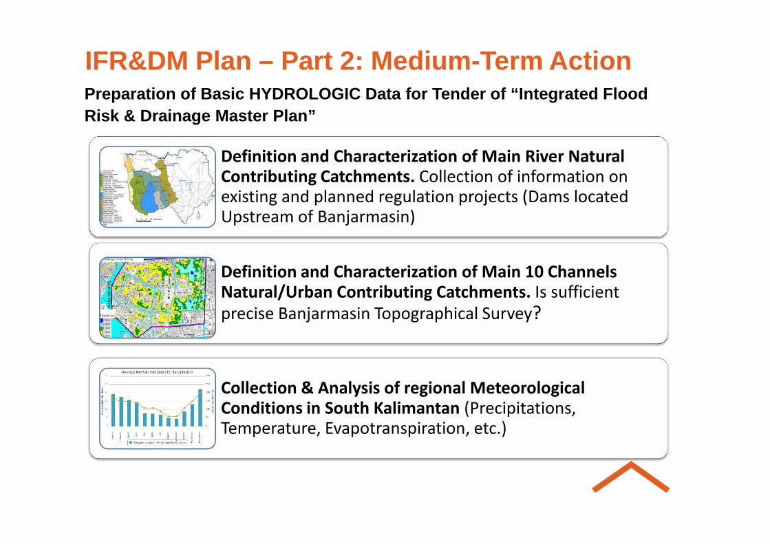
IFR&DM Plan – Part 2: Medium -Term ActionPreparation of Basic HYDROLOGIC Data for Tender of “Integrated Flood Risk & Drainage Master Plan”
Definition and Characterization of Main River Natural Contributing Catchments. Collection of information on existing and planned regulation projects (Dams located Upstream of Banjarmasin)
Definition and Characterization of Main 10 Channels Definition and Characterization of Main 10 Channels Natural/Urban Contributing Catchments. Is sufficient
precise Banjarmasin Topographical Survey?
Collection & Analysis of regional Meteorological Conditions in South Kalimantan (Precipitations, Temperature, Evapotranspiration, etc.)

IFR&DM Plan – Part 2: Medium -Term ActionPreparing Basic HYDROLOGIC Data for Tender of “Integ rated Flood Risk & Drainage Master Plan”
Regional “Flood Estimation” Study – Hydrologic Modellingfor Flood Risk Assessment
Flow-Frequency curves, Intensity-Duration-Frequency Curves
Analysis of Flood Risk Sources (Tidal FR, Fluvial FR, Foul Sewer Network FR) based on Risk Approach and Flood Sewer Network FR) based on Risk Approach and Flood Mapping Exercise
Flood Risk = Probability x Consequences
Spatial and Temporal Structure of Flows and Levels by Hydraulic System Modelling

IFR&DM Plan – Part 3: Long -Term StrategyOnce “Integrated Flood Risk & Drainage Master Plan” i s produced:
Based on “Flood Risk & Level of Protection” to be provided, Analysis of Alternatives (Engineering & Non-Structural) and Cost-Benefit Analysis
Legislation, Regulation and Institutional Framework
Production of Plan of Investments and Financial Support Production of Plan of Investments and Financial Support (Public, Private and PPP)
Implementation of Preferred Options (PD&DD, Tender & Construction Stages) and Implementation of O&M Plan
Therefore, will you build up based on solid foundations? SURE, TERIMA KASIH!

Discussion on Technical Solutions“Space for Rivers” <> “Flood River Protections” (“Room for the Rivers” Project (Netherlands, 2001-2015); “Not to ensure against flood risk” policy (Netherlands, UK), floodplains and flood storage rehabilitation, Ecosystems Services Benefits in the Master Plan
• Ecosystems Tangible Economic Benefits
•Food: mango, banana, rambutan
•Fiber/Resin: rubber•Fiber/Resin: rubber
•Timber: galam
•Fuel: peat (gambut)
• Ecosystems Intangible Economic Benefits
•Water quality
•Flood regulation
•Shoreline protection
•Soil conservation

Discussion on Technical Solutions“Emergency Floodhills” → Flood Alerts, EvacuaJon,
Emergency Response and Recovery? Meuse Valley Flood (Netherlands 1993 and 1995), Tsunami (Indonesia 2004, Japan 2011), Cyclone Katrine (USA 2005), Cyclone Xynthia(France 2010), Cyclone Yolanda (Philippines 2013) →
Awareness!
1. National Policy for “Disaster
Mitigation & Relief”? Mitigation & Relief”?
2. IFR&DM Plan to look at future
potential disaster events?

Discussion on Technical Solutions
Sedimentation process → DeforestaJon Process?
Legislation & Regulation? Environmental Awareness!
Banjarmasin prominent ecosystems for conservation
from urban development (clearing, land filling, etc.)
KanalKanal AwangAwang Jafri Jafri ZamZam ZamZam
Sungai Sungai MartapuraMartapura

Discussion on Technical Solutions
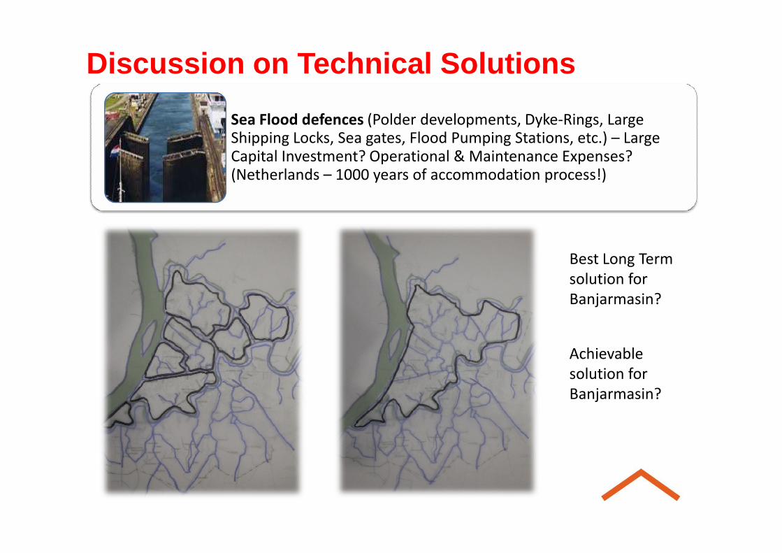
Sea Flood defences (Polder developments, Dyke-Rings, Large Shipping Locks, Sea gates, Flood Pumping Stations, etc.) – Large Capital Investment? Operational & Maintenance Expenses? (Netherlands – 1000 years of accommodation process!)
Discussion on Technical Solutions
Sea Flood defences (Polder developments, Dyke-Rings, Large Shipping Locks, Sea gates, Flood Pumping Stations, etc.) – Large Capital Investment? Operational & Maintenance Expenses? (Netherlands – 1000 years of accommodation process!)
Best Long Term
solution for solution for
Banjarmasin?
Achievable
solution for
Banjarmasin?

TERIMA KASIH21-2-2015
Therefore, will we build up based on “solid foundations”?