sheldon/charter oak neighborhood, hartford ct · sheldon/charter oak neighborhood, hartford ct 1...
TRANSCRIPT

HUYSHOPE AND VAN DYKE AVENUES CORRIDOR STUDYSHELDON/CHARTER OAK NEIGHBORHOOD, HARTFORD CT
Prepared byBuckhurst Fish & Jacquemart, Inc.
In association with David Mann Associates
For the City of Hartford, and theCoalition to Strengthen the Sheldon/Charter Oak Neighborhood (CSS/CON)
June 2001

SHELDON/CHARTER OAK NEIGHBORHOOD, HARTFORD CT 1
HUYSHOPE AND VAN DYKE AVENUES CORRIDOR STUDYSHELDON/CHARTER OAK NEIGHBORHOOD, HARTFORD CT
1.0 STUDY OBJECTIVES 2
2.0 DEVELOPMENT HISTORY AND CONTEXT 3
3.0 PREVIOUS PLANNING STUDIES 53.1 Riverfront Recapture3.2 Sheldon Charter Oak NRZ Strategic Plan
4.0 TRAFFIC DATA ANALYSIS 7
5.0 TRAFFIC IMPACTS OF NEW DEVELOPMENT 105.1 Capewell Court/Riverfront Recapture5.2 Dillon Stadium5.3 Coltsville Heritage Park5.4 Adriaen’s Landing
6.0 PROPOSALS 126.1 Huyshope Avenue6.2 Van Dyke Avenue6.3 Potential Stadium Development6.4 Riverfront Connections and Development
7.0 COST ESTIMATES 26
8.0 APPROVALS AND FUNDING SOURCES 26
9.0 APPENDIX: Street Connection Options 29
FiguresFigure 1 – Neighborhood Location within Hartford, CT 2Figure 2 – Local Context Map showing Land Uses and Neighborhoods 4Figure 3 – Riverfront Restaurant (Riverfront Recapture) 5Figure 4 – Riverfront Connection (Riverfront Recapture) 5Figure 5 – Total number of Vehicles per Day on 7
Huyshope and Van Dyke AvenuesFigure 6 – Van Dyke/ Huyshope Corridor Concept Plan 11Figure 7 – Example of Neckdown on Huyshope Avenue 12Figure 8 – Proposed Stop Sign Location on Huyshope Avenue 12Figure 9 – Cross Section of Huyshope Avenue 13Figure 10 – Street Detail of Huyshope Avenue 14Figure 11 – Cross Section of Van Dyke Avenue 16Figure 12 – Street Detail of Van Dyke Avenue 17Figure 13 – Pedestrian Crossing Location on Van Dyke Avenue 17Figure 14 – Plan of Dillon Stadium Parking Lot 19Figure 15 – Proposed Northern Connection to Riverfront 22Figure 16 – Plan Detail of Northern Connection to Riverfront 23Figure 17 – Plan Detail of Southern Connection to Riverfront 23Figure 18 – Proposal Plan 25
TablesTable 1 – Summary of City of Hartford Traffic Data for the Van 7
Dyke/Huyshope CorridorTable 2 – Traffic and Parking Survey of Pending 10
Development ProjectsTable 3 – Parking Requirements and Availability for 20
Dillon Stadium DevelopmentTable 4 – Estimated Costs for Proposed Improvements 27Table 5 – Estimated Costs for Complete Proposals 28
1.0 STUDY OBJECTIVES

SHELDON/CHARTER OAK NEIGHBORHOOD, HARTFORD CT 2
In 1995, the State of Connecticut established guidelines for the formation of NeighborhoodRevitalization Zones (NRZs), to enable communities to locally engage in the process of planning. Asone of the first Hartford neighborhoods to complete a NRZ Strategic Plan, the Sheldon/Charter Oakneighborhood has already identified priorities for neighborhood improvements. However, in order torealize these priorities in the near future, the Sheldon/Charter Oak neighborhood must concentrateresources on defined community initiatives.
The consulting firm of Buckhurst Fish & Jacquemart, Inc. (BFJ) was retained by the City of Hartford,to help the Coalition to Strengthen the Sheldon/Charter Oak Neighborhood (CSS/CON) identifyspecific projects for neighborhood investment. These projects have their basis in the neighborhoodissues defined in the completed Strategic Plan for the Sheldon/Charter Oak NRZ (2000), and shouldbe considered as a supplement to the existing plan. The following urban design analysis includes fourmajor development initiatives:
§ Traffic calming on Huyshope Avenue§ Boulevard concept for Van Dyke Avenue§ Potential Dillon Stadium Expansion§ Riverfront Connections and Developments
The options for each of these projects have been discussed with the CSS/CON board and aresupported by estimates of current and projected traffic generation in the Sheldon/Charter Oakneighborhood. The second section of this study presents general cost estimates for the developmentinitiatives, and recommendations for possible funding sources.
This document is an amendment to the CSS/CON NRZ Strategic Plan. Upon approval by the Court ofcommon Council it will be an attachment to the document noted as “Sheldon Charter Oak NRZ,March 8, 2000”, in Section 28-196 of the Hartford Municipal Code. CSS/CON will encourage the Cityof Hartford to implement the recommendations contained herein and while approval of the Plan by theCity of Hartford signifies an agreement in principal to the concepts presented, the City is not precommitted to any specific course of action.
Figure 1Neighborhood Location within Hartford, CT

SHELDON/CHARTER OAK NEIGHBORHOOD, HARTFORD CT 3
2.0 DEVELOPMENT HISTORY AND CONTEXT
Located on the fringe of Downtown Hartford, the Sheldon/Charter Oak neighborhood was once thecenter of economic prosperity in Hartford. In 1623 it was the site of the original colonial settlement,and later it was the hub of Samuel Colt’s industrial arms enterprise. During the Colt Era communityactivities were focused around a thriving factory complex that included the manufacturing buildings,Armsmear (the Colt home) and worker’s housing. Much of this land was later willed to the City ofHartford, and was used to create Colt Park, which opened for public use in 1905, and many of theearlier buildings are recognized Hartford landmarks.
Large tracts of medium density multifamily housing are also a defining feature of the Sheldon/CharterOak neighborhood. Some of these housing developments, including Dutch Point, are underconsideration for physical improvement with an emphasis on mixing incomes and building community.Although these developments are dense and in need of maintenance, the residents have access toColt Park, an enviable asset in a downtown neighborhood. Other residential options in theneighborhood include multi-unit apartments, condominiums and artists live/work studios.
The neighborhood is supported by a scattering of commercial, retail and office uses along MainStreet, Huyshope, Charter Oak and Wethersfield Avenues (Figure 2). Dillon Stadium, has ability toaccommodate a variety of sporting events, and is located near the southern end of the Huyshopecorridor. With a developer’s investment, it could be adapted for several uses, including minor leaguebaseball.
Coltsville Heritage Park
Colt Estates
SHELDON/CHARTER OAK NEIGHBORHOOD, HARTFORD CT 4
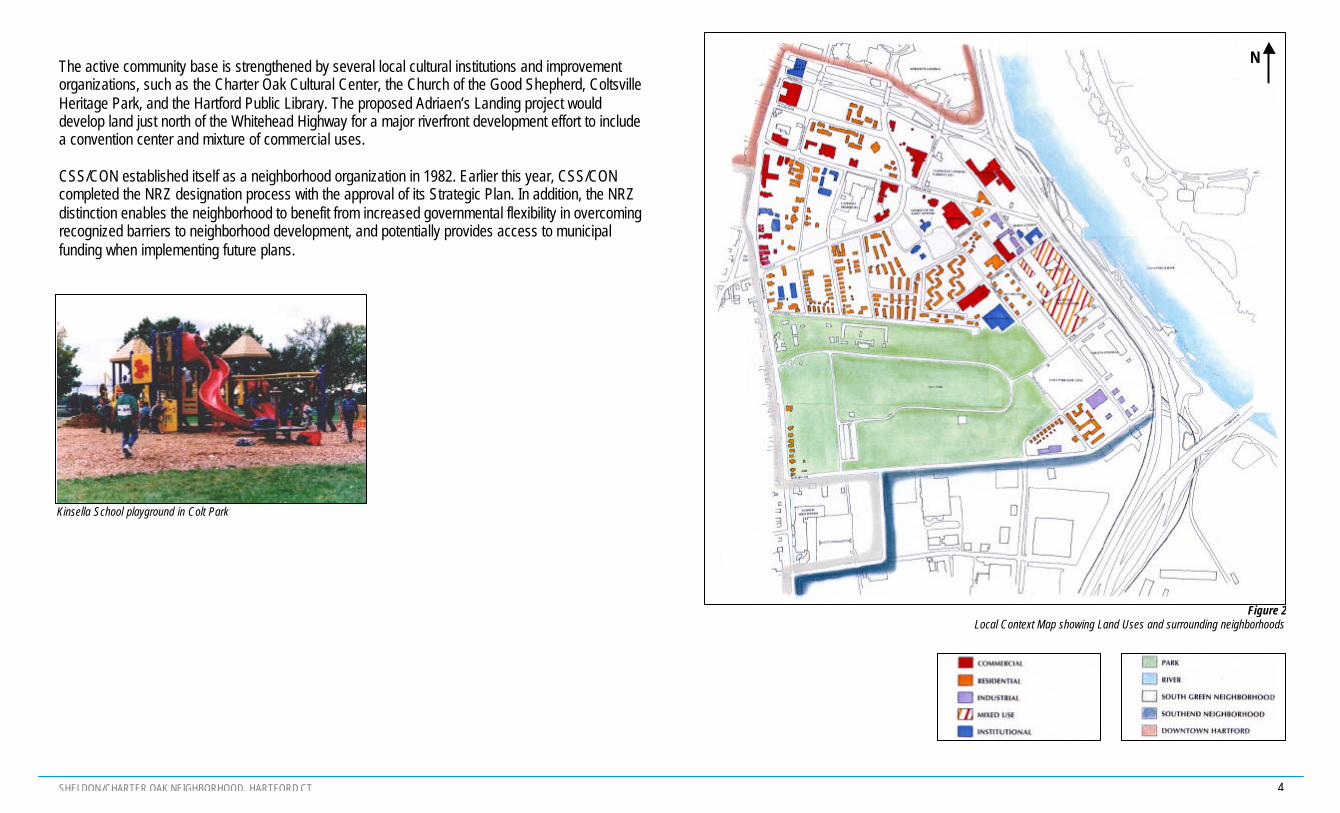
The active community base is strengthened by several local cultural institutions and improvementorganizations, such as the Charter Oak Cultural Center, the Church of the Good Shepherd, ColtsvilleHeritage Park, and the Hartford Public Library. The proposed Adriaen’s Landing project woulddevelop land just north of the Whitehead Highway for a major riverfront development effort to includea convention center and mixture of commercial uses.
CSS/CON established itself as a neighborhood organization in 1982. Earlier this year, CSS/CONcompleted the NRZ designation process with the approval of its Strategic Plan. In addition, the NRZdistinction enables the neighborhood to benefit from increased governmental flexibility in overcomingrecognized barriers to neighborhood development, and potentially provides access to municipalfunding when implementing future plans.
Kinsella School playground in Colt Park
Figure 2Local Context Map showing Land Uses and surrounding neighborhoods
N

SHELDON/CHARTER OAK NEIGHBORHOOD, HARTFORD CT 5
3.0 PREVIOUS PLANNING STUDIES
3.1 Riverfront Recapture
The Riverfront Recapture plan, completed in 1982, presents a unified vision for the future of theConnecticut River as a shared resource of Hartford and East Hartford. By identifying the protectedriverfront area as part of a regional park system, this plan was the initial step towards changing theriverfront from an industrial and transportation corridor into a community asset. The RiverfrontRecapture plan included four main objectives necessary to realizing the potential of the Hartford/EastHartford riverfront:
§ To connect neighborhoods and urban areas to the water’s edge, crossing expressway,rail-line and dike barriers;
§ To establish riverfront attractions which will expand the region’s recreational andeducational opportunities;
§ To link riverfront activities by means of a continuous linear park, making the entire river’sedge available for biking, hiking, picnicking and exploring;
§ To restore the riverfront’s significance as an important part of the region’s economic life(Riverfront Recapture, 1982).
The Riverfront Recapture plan included several initiatives for the Sheldon/Charter Oak neighborhood.In the short term, the priorities for the neighborhood were identified as the construction of a riverfrontrestaurant, boathouse and launching facility beneath the Charter Oak Bridge (Figure 3), and thedevelopment of a new riverfront entry on the Northeast Utilities cable storage site (Figure 4).Streetscaping and decoration were considered crucial to the success of a riverfront gateway to thenorth of Coltsville, and it was thought that additional parking could be accommodated underneath thehighway, if necessary.
Figure 3Riverfront Restaurant at Charter Oak Landing
Proposed in Riverfront Recapture, 1982
Figure 4Riverfront Connection at the north end of Van Dyke Avenue
Proposed in Riverfront Recapture, 1982

SHELDON/CHARTER OAK NEIGHBORHOOD, HARTFORD CT 6
Long term development plans for the area included proposals for both sides of the dike. Several siteswere identified for residential and office development, including Coltsville, the Northeast Utilitiesparking lot, and the BRS (State) parking lot (owned by Coltsville, on the northwest corner ofHuyshope Avenue). Riverfront Recapture also proposed that the City invest in the stability of thecommunity by expanding maintenance efforts aimed at publicly assisted housing. The futurerenovation of Coltsville and Dillon Stadium were also predicted, along with the resultant increase inrequired parking spaces. Parking expansion was recommended for the lots directly to the north andwest of Dillon Stadium. The long term vision for Riverfront Recapture also stated that attention shouldbe paid to the design of Van Dyke, Huyshope and Charter Oak Avenues, but did not specifystreetscaping initiatives.
3.2 Sheldon/Charter Oak NRZ Strategic Plan
The CSS/CON NRZ Strategic Plan “provides a policy direction for public decisions specific to theSheldon/Charter Oak Neighborhood”. The Strategic Plan presents the economic, demographic andphysical condition of the neighborhood, and uses this knowledge to describe local challenges andassets. It uses this background material to define goals and strategies for the neighborhood, butstops short of identifying specific project plans. The major strategies include the following:
§ Colt Park Initiative§ Traffic and Pedestrian Planning§ Van Dyke Pedestrian Corridor§ Charter Oak Avenue Gateway Park§ Pulaski Mall Renovation§ Wyllys Street Development Zone
Of these, BFJ has outlined specific projects to help realize a portion, or all of, the first three strategieslisted above. In particular, this report focuses on a solution for the Van Dyke/Huyshope pedestriancorridors, the traffic and parking issues related to upgrading Dillon Stadium, and local riverfrontaccess.
SHELDON/CHARTER OAK NEIGHBORHOOD, HARTFORD CT 7
4.0 TRAFFIC DATA ANALYSIS
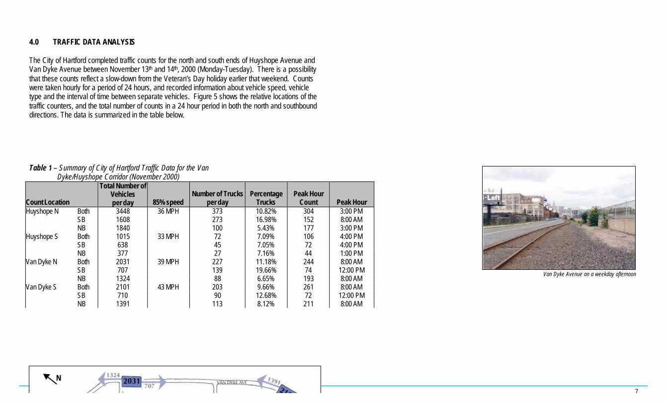
The City of Hartford completed traffic counts for the north and south ends of Huyshope Avenue andVan Dyke Avenue between November 13th and 14th, 2000 (Monday-Tuesday). There is a possibilitythat these counts reflect a slow-down from the Veteran’s Day holiday earlier that weekend. Countswere taken hourly for a period of 24 hours, and recorded information about vehicle speed, vehicletype and the interval of time between separate vehicles. Figure 5 shows the relative locations of thetraffic counters, and the total number of counts in a 24 hour period in both the north and southbounddirections. The data is summarized in the table below.
Table 1 – Summary of City of Hartford Traffic Data for the Van Dyke/Huyshope Corridor (November 2000)
Count Location
Total Number ofVehiclesper day 85% speed
Number of Trucksper day
PercentageTrucks
Peak HourCount Peak Hour
Huyshope N Both 3448 36 MPH 373 10.82% 304 3:00 PMSB 1608 273 16.98% 152 8:00 AMNB 1840 100 5.43% 177 3:00 PM
Huyshope S Both 1015 33 MPH 72 7.09% 106 4:00 PMSB 638 45 7.05% 72 4:00 PMNB 377 27 7.16% 44 1:00 PM
Van Dyke N Both 2031 39 MPH 227 11.18% 244 8:00 AMSB 707 139 19.66% 74 12:00 PMNB 1324 88 6.65% 193 8:00 AM
Van Dyke S Both 2101 43 MPH 203 9.66% 261 8:00 AMSB 710 90 12.68% 72 12:00 PMNB 1391 113 8.12% 211 8:00 AM
Van Dyke Avenue on a weekday afternoon
N

SHELDON/CHARTER OAK NEIGHBORHOOD, HARTFORD CT 8
The key findings from this traffic analysis are:
§ The traffic on Huyshope and Van Dyke Avenues is substantially under capacity. Overall,the traffic utilizing the neighborhood streets is relatively low. One concern expressed byCSS/CON was the tendency of some drivers to utilize Van Dyke and Huyshope Avenues assouthern “short-cuts” into downtown Hartford. While some drivers may be doing this they arerelatively few in number. Traffic on both roads is well below the respective capacities of theroads. This indicates that the highway system (I-91, Whitehead Highway) is functioning wellenough in peak hour to encourage most drivers to utilize the expressway system. As long as thissystem operates well, the local roads will continue to serve neighborhood access functions asopposed to being major arteries to downtown. For example, Van Dyke Avenue has the capacityto handle in excess of 1200 vehicles in peak hour, but traffic counts indicate that it currentlyhandles 261 vehicles in the morning peak hour – only a fifth of its capacity.
§ Van Dyke Avenue is a Through Street. Traffic primarily moves through the neighborhood alongVan Dyke Avenue. This finding is supported by the similar volumes of vehicles counted at thenorth and south ends of the street.
§ Huyshope Avenue is a Neighborhood Street with a wider mix of uses. Huyshope Avenuecurrently experiences much higher volumes of traffic at the north end of the street – over threetimes the number of vehicles as the southern end of the street, in the same time period. Theincreased activity is probably the result of the mix of uses located at the northern end ofHuyshope Avenue. Whereas a recycling facility and Dillon Stadium are located south of MasseekStreet, the north end of the street supports a warehousing supermarket, residential access,Kinsella School, Coltsville and access to the State Parking Lot. In the future, the southern end ofMasseek street may support higher-traffic uses, but for the moment, the primary center ofneighborhood vehicular activity is at the north end of Huyshope Avenue.
§ Speeding is more common on Van Dyke Avenue. Throughout the City of Hartford the speedlimit is 30 MPH, unless otherwise posted. At the south end of Van Dyke Avenue, however, 85%of the vehicles were traveling at or below 43 MPH. Speeds were generally lower but still abovethe City speed limit at the north end of Van Dyke Avenue, where 85% of the vehicles are travelingbelow 39 MPH. By making the road appear visually smaller, through the use of trees, streetamenities and wider sidewalks. it is possible to encourage drivers to slowdown withoutsubstantially decreasing the lane width or limiting the function of Van Dyke Avenue as a throughstreet. On Huyshope Avenue the reverse pattern appears to be true – 85% of the vehicles aretraveling below 36MPH at the north end, as compared to only 33 MPH at the south end. This maybe the result of people exiting Charter Oak Avenue, but not slowing their speed until they arefarther along Huyshope Avenue, or it may be that northbound vehicles increase in speed alongHuyshope Avenue. These findings reflect the consultant teams’ observation that Van DykeAvenue serves as a more important artery for through traffic, whereas Huyshope Avenue servesa more distinctly neighborhood function.
§ Huyshope and Van Dyke Avenues experience different peak traffic hours. Peak traffic timesalong Huyshope Avenue appear to be in the early to mid afternoon, with the majority of vehiclesleaving the neighborhood (moving north from the northern end and south from the southern end).Van Dyke Avenue experiences a different pattern. Along Van Dyke Avenue the peak traffic timeis in the morning, around 8 AM, when most vehicles appear to be moving north, towardsdowntown Hartford. However, according to these traffic counts, Van Dyke Avenue continues tocarry more vehicles than Huyshope Avenue, even during the afternoon hours.

SHELDON/CHARTER OAK NEIGHBORHOOD, HARTFORD CT 9
§ Truck traffic along Huyshope Avenue is strongly weighted to the north end of the street.Truck traffic accounts for a larger proportion of vehicles along Van Dyke Avenue, but in absolutenumbers, there are more trucks at the north end of Huyshope Avenue than elsewhere alongHuyshope or Van Dyke Avenues. Although truck traffic along Van Dyke Avenue appears to beevenly distributed along the length of the street, with roughly 200 trucks per day recorded, thetruck traffic on Huyshope Avenue is substantially weighted to the north end of the street. Anyproposed traffic calming measures along Huyshope Avenue should take into account theunbalanced distribution of truck traffic.
5.0 TRAFFIC IMPACTS OF NEW DEVELOPMENT
In terms of assessing potential traffic impacts on the Sheldon/Charter Oak neighborhood, the mostsignificant proposals under consideration are Capewell Court, Riverfront Recapture, Dillon Stadium,Coltsville, and Adriaen’s Landing.
5.1 Capewell Court/Riverfront Recapture
Capewell Court and Riverfront Recapture are two ongoing projects that will marginally affect traffic inthe Sheldon/Charter Oak neighborhood. A new, self-contained housing development on the Capewellproperties, the Capewell Court development will have relatively little impact on neighborhood traffic,as access is provided off of Wethersfield Avenue.
A small amount of parking for Riverfront recreation should be provided in the neighborhood, asdescribed in Section 6.3.1, but in general, there will be no appreciable increase in vehicular traffic dueto the new riverfront recreation sites. However the neighborhood may notice some changes in theamount of pedestrian traffic once physical links to Riverfront have been established.
5.2 Dillon Stadium
The major parking and traffic flow issues inherent in the redevelopment of Dillon Stadium for minorleague baseball use are discussed in Sections 6.3.1 and 6.3.2. Approximately 1200 local parkingspaces can be found to support an expanded stadium, between on-street and surface parking lots.Peak use for a stadium will occur in the evenings and on weekend, and therefore will not be inserious conflict with existing neighborhood uses. During peak hour, most traffic will travel onHuyshope and Van Dyke Avenues to Wawarme or Charter Oak Avenues.
Truck Traffic on Huyshope Avenue

SHELDON/CHARTER OAK NEIGHBORHOOD, HARTFORD CT 10
5.3 Coltsville Heritage Park
With new renovations, parking for Coltsville Heritage Park will be almost entirely self-contained.Between on-street resources, and the Coltsville parking lots, there is ample parking for both residentsand businesses. Since predicted peak traffic hours differ, Coltsville and Dillon Stadium attendeesshould be able to share on-street parking spaces. In the future, should the State Parking Lot berelocated, Coltsville would gain over 100 spaces in the private parking area that is now leased to theState of Connecticut.
5.4 Adriaen’s Landing
Technical memoranda supporting the Environmental Impact Statement (EIS) Traffic DistributionPredictions for Adriaen’s Landing suggest that it will not have significant adverse impact onneighborhood streets in the Sheldon/Charter Oak neighborhood. Figure 6 shows the proposed siteplan of Adriaen’s Landing as of early 2000. The development will have excellent access to I-91 viathe Whitehead Highway and Grove Street. According to the models presented in the EIS predictions,virtually all of the traffic for Adriaen’s Landing will enter or exit the development via the WhiteheadHighway, I-91 or I-84. However, the predictions show that the development will add close to 200 carsto I-91, and another 150 cars to the Whitehead Highway during the evening peak hour on a weekday.With these additional vehicles being added to the nearby highways in peak hour, the properfunctioning of the interstate system is important to keeping this regional traffic off of local roads.
Table 2 – Traffic and Parking Survey of Pending Development Projects(modified from CSS/CON Parking Committee, December 1999)
CapewellCourt
Dillon Stadium ColtsvilleHeritage Park
RiverfrontRecapture
Adriaen’sLanding
ProjectType Housing Recreational Mixed Use Recreational Mixed UseSize 105 units 5,000 seats 360,000 sf N/A Various
TimetableConstruction 2001 2000 1999 TBD 2001Complete 2001 2001 2002 TBD 2003Operating 2001 2001 2003 TBD Unknown
ProposedParking
Surface 120 1700 1000 250 0Garage 80 0 0 0 10,000Total need 200 1700 1000 250 10,000Available Unknown Unknown 896 Unknown 10,000
TrafficTrips/day 100 TBD/43 games TBD 580 TBDPeak Hours AM &PM 6PM-10PM
WeekendPMWeekend
12PM-4PM TBD
SHELDON/CHARTER OAK NEIGHBORHOOD, HARTFORD CT 11
6.0 PROPOSALS
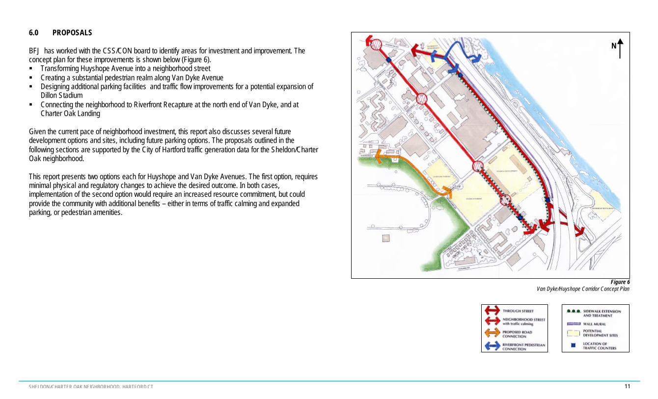
BFJ has worked with the CSS/CON board to identify areas for investment and improvement. Theconcept plan for these improvements is shown below (Figure 6).§ Transforming Huyshope Avenue into a neighborhood street§ Creating a substantial pedestrian realm along Van Dyke Avenue§ Designing additional parking facilities and traffic flow improvements for a potential expansion of
Dillon Stadium§ Connecting the neighborhood to Riverfront Recapture at the north end of Van Dyke, and at
Charter Oak Landing
Given the current pace of neighborhood investment, this report also discusses several futuredevelopment options and sites, including future parking options. The proposals outlined in thefollowing sections are supported by the City of Hartford traffic generation data for the Sheldon/CharterOak neighborhood.
This report presents two options each for Huyshope and Van Dyke Avenues. The first option, requiresminimal physical and regulatory changes to achieve the desired outcome. In both cases,implementation of the second option would require an increased resource commitment, but couldprovide the community with additional benefits – either in terms of traffic calming and expandedparking, or pedestrian amenities.
Figure 6Van Dyke/Huyshope Corridor Concept Plan
N

SHELDON/CHARTER OAK NEIGHBORHOOD, HARTFORD CT 12
6.1 Huyshope Avenue
Huyshope Avenue currently supports much of the commercial and community facilities of theSheldon/Charter Oak neighborhood, and provides access to most of the nearby housing. Theavenue functions as a neighborhood street, but without active uses that face directly on to the street,drivers have a tendency to speed along to Charter Oak or Wawarme Avenues. The primary goal forplanning this area, is to reinforce the concept of a street with a pedestrian dynamic.
6.1.1 Option One – Neckdowns and One On-street Parking Lane
There are several traffic-calming strategies that can be used to achieve the physical qualities of aneighborhood street. As illustrated in Figure 6, the proposal includes neckdowns for the corners ofCharter Oak Avenue, Sequassen Street, Masseek Street, and Curcombe Street. No neckdown isplanned for the corner of Nepaquash Street, as such a strategy would conflict with the trucksentering and exiting Kopplemanns.
One key traffic safety issue identified by CSS/CON is the intersection of Charter Oak and HuyshopeAvenues. The angle of this “T” shaped intersection, is such that right turns from Charter Oak Avenueonto Huyshope Avenue have a free flow movement. However, taking a left turn from HuyshopeAvenue onto Charter Oak Avenue can be a difficult movement for some drivers. In particular, parkedcars on the south side of Charter Oak Avenue, east of the intersection with Huyshope Avenue, restrictthe visibility of vehicles turning left from Huyshope Avenue onto Charter Oak Avenue. To alleviate thisthe City could consider neckdowns and stop signs on the northeast and southeast corners of theintersection between Charter Oak and Huyshope Avenues (Figure 8). As a result of this measure,right turns will no longer be allowed off of Huyshope at this intersection. Parking on Charter OakAvenue should be set back from this intersection to provide unimpaired views of oncoming traffic.Until these traffic calming measures are implemented, and an assessment of their impact has been
made, stop signs are not recommended as traffic calming devices for other areas in theneighborhood.
On-street parking is currently permitted only in the evening (7pm to 7am), on the west side ofHuyshope Avenue. However, having on-street parking helps to slow through traffic, as driversbecome more tentative when the road appears narrower. With Option One, parking should bepermitted on the west side of Huyshope Avenue at all times. By lifting the current time-of-day parkingregulations, the existing 35.5 ft road would be visually narrowed to just over 24 ft wide. At thosedimensions, the existing truck traffic would not be hindered, and no restriping of the road bed wouldbe necessary. None of this additional parking should be metered, but City regulations regarding 3hour parking limits should be maintained along Huyshope Avenue.
If the proposal for an expanded Dillon Stadium is approved and built, additional parking for gamescould be provided on the east side of Huyshope Avenue. Without restriping, this additional parkingwould effectively be located in the northbound traffic lane, and consequently should only beconsidered for specific high-volume events.
Entrance to Kopplemanns, off Nepaquash Street
Figure 8Huyshope Avenue
Stop Sign location at Charter Oak Avenue
Figure 7Huyshope Avenue
Neckdown at Masseek Street

SHELDON/CHARTER OAK NEIGHBORHOOD, HARTFORD CT 13
6.1.2 Option Two - Restriping for Two On-street Parking Lanes
The traffic calming strategies presented in Option One, are taken slightly further with Option Two. Inthe second option, Huyshope Avenue could be restriped to allow for on-street parking on both sidesof the street. With this option, no curbing changes are required. Traffic and parking lane widths arereduced, however, in order to allow for two 10.75 ft traffic lanes and two 7 ft parking lanes. This optionwould require the approval of the City of Hartford engineers to be certain that the lane widths forvehicle travel and parking are acceptable. Option Two is recommended only if adequate off-streetparking cannot be accommodated by future development.
Existing Road on Huyshope Avenue
Figure 9Huyshope Avenue
Cross Section and Plan Details of Options 1 and 2

SHELDON/CHARTER OAK NEIGHBORHOOD, HARTFORD CT 14
6.1.3 Pedestrian improvements
The pedestrian realm throughout the Sheldon/Charter Oak neighborhood is in need of seriousconsideration. The neckdowns proposed in Option One will create new places for pedestrianamenities, and will facilitate structured pedestrian crossings at major intersections along HuyshopeAvenue. Both options should also incorporate the image of Huyshope Avenue as a tree-lined street,with rows of trees along both the east and west sidewalks. These trees will buffer pedestrians fromthe large scale of buildings like Coltsville, from the traffic along Huyshope, and from climatic effects.
Connecting the disparate pieces is crucial when creating a pedestrian circulation system. As it exists,several links in the pedestrian circulation system for this portion of the Sheldon/Charter Oakneighborhood are either missing or in need of repair. One such area is the strip of Huyshopebetween Masseek Street and Wawarme Avenue, where the eastern sidewalk is absent and thewestern sidewalk is in disrepair. Although this stretch of sidewalk is particularly important given thefuture development options for Dillon Stadium, additional pedestrian amenities and connections arenecessary throughout, for a physically cohesive neighborhood. Attention should be paid to a plannedsidewalk on the east side of Huyshope Avenue, next to Dillon Stadium, and this strip should beconnected along Wawarme to the proposed pedestrian realm on Van Dyke Avenue. Constructing anew sidewalk in this area should not be an outrageous expense, as existing buildings have been builtto the setback, and there are no major trees on this section of the avenue. The illustrated planindicates locations for pedestrian crossings, many of which will coincide with neckdowns that reducethe crossing distance.
Existing Trees and Sidewalk on Huyshope Avenue
Huyshope AvenueSouth of Masseek Street
Huyshope AvenueSouth of Curcombe Street
Figure 10Huyshope Avenue
Option 2 Plan Detail

SHELDON/CHARTER OAK NEIGHBORHOOD, HARTFORD CT 15
6.2 Van Dyke Avenue
Van Dyke Avenue is a connector between downtown Hartford (via Charter Oak Avenue) and thesouth meadows (via Wawarme Avenue and Airport/Reserve Road). Van Dyke Avenue separatesColtsville Heritage Park from Interstate-91, which runs along the Connecticut River. Due to thelocation at the eastern edge of the neighborhood, and the few active uses that front on to the street,Van Dyke Avenue has become the primary street for vehicular traffic through the neighborhood.Traffic data and observations suggest that most of the traffic on Van Dyke Avenue continues throughthe Sheldon/Charter Oak neighborhood, moving through to downtown or south Hartford. A similarpattern is true of pedestrian traffic, as well, with occasional pedestrians, joggers and cyclists usingVan Dyke Avenue as an access route between downtown and Charter Oak Landing.
Although Van Dyke Avenue could be modified to support significant pedestrian amenities or vehicleparking, the existing uses, fronting buildings and the one-sided design of the avenue suggest thatsmaller scale changes may be more productive. The following two options could be completed asconsecutive phases, or independently. In either case, the traffic and parking lanes are not narrowedbeyond the current regulations for the City of Hartford, and the pedestrian realm is considerablyimproved on the western edge of Van Dyke Avenue. With a “boulevard” concept along the westernside, Van Dyke Avenue will maintain the characteristics of a through street, while providing anappreciable pedestrian environment and buffer. In constructing a pedestrian realm it is important tocreate a neighborhood supplement to Huyshope Avenue, that complements the natural appeal of thenearby Riverfront Recapture projects. This can be achieved in many ways, including the use ofplanters, pedestrian lighting, banners and newly planted street trees.
6.2.1 Option 1 – Pedestrian Sidewalk
As it currently exists, Van Dyke Avenue has a 6 ft sidewalk on the western side, one lane of on-streetparking and two traffic lanes with a curb-to-curb distance of 38 ft. Although the sidewalk itself is quitegenerous, it is squashed between an unfriendly chain-link fence around Coltsville, telephone poles,streetlights and on-street parking. To the pedestrian, the sidewalk appears to be an afterthought – somuch so that many of the joggers that frequent Van Dyke Avenue prefer to run on the street itself. Byreplacing the existing fencing with a more appealing alternative, and moving the fencing towards thebuilding by 1 ft, the appearance of the sidewalk could be dramatically improved with relatively littleexpense.
The first option that BFJ considered for Van Dyke Avenue is to move the curb on the western side ofthe road into the existing street bed by an additional 4 ft. This will create enough space to have agreen edge with planted trees between the curb and the sidewalk. With this option, enough roomremains to have a 10 ft parallel parking lane along the western side of Van Dyke Avenue, and two 12ft travel lanes. This option meets all American Association of State Highway and TransportationOfficials (AASHTO) road standards.
Lunchtime jogger on the east side of Van Dyke Avenue

SHELDON/CHARTER OAK NEIGHBORHOOD, HARTFORD CT 16
6.2.2 Option 2 – Shared Path
Another option for the same street would be to move the curb 7 feet into the road bed. With thisadditional space, there would be enough room to include both a green edge along the western side ofVan Dyke Avenue, and a large enough pedestrian zone for a shared use path for cyclists, joggersand pedestrians. A path width of 8-12 ft satisfies AASHTO standards for a two-way shared use path.For this specific case, it is justifiable to use a smaller dimension because bicycle and pedestrian useis expected to be low and maintenance uses will not be in conflict with the path on a regular basis.With an extended sidewalk, the western edge of Van Dyke Avenue would also be large enough tohold stalls and carts for flea markets and local artisan sales in good weather. Even though Van DykeAvenue has potential as a pedestrian friendly street, may be unwise to divert resources towardscreating a third pedestrian zone in such proximity to Huyshope Avenue and the Riverfront Recaptureprojects. By extending the sidewalks to create a multi-use path, Van Dyke Avenue can accommodateneeded neighborhood uses, such as safe areas for commuter cycling and artisan exhibition space,without competing with the local character of Huyshope Avenue.
On-street parking is still recommended for the western side of Van Dyke Avenue, but in this case theparking lane width will be reduced to 8 ft. Hopefully a slight reduction in the curb-to-curb distance(without decreased travel lane widths) will encourage drivers to decrease their speeds, as the on-street parking and tree-lined buffer will create the illusion that the road is narrower than it is today.As in the first option, through traffic lanes remain 12 ft wide.
Figure 11Van Dyke Avenue
Cross Section and Plan Detail of Options 1 and 2

SHELDON/CHARTER OAK NEIGHBORHOOD, HARTFORD CT 17
6.2.3 Other Improvements
Beyond the reinvestment efforts for the existing pedestrian realm along Van Dyke Avenue, there areseveral other areas of concern. A few of these other opportunities are described below and shown onthe concept plan.
§ The existing chain-link fence that encloses the Coltsville Heritage Park should be replaced withan equally-functional, but more aesthetic alternative, such as wrought-iron style fencing. Evensuch a simple change as replacing the existing fencing will produce a huge perceptualimprovement in the pedestrian experience of Van Dyke Avenue.
§ Unfortunately, the few pedestrian amenities that exist along Van Dyke Avenue stop at MasseekStreet. The existing sidewalk should be extended from Masseek Street to Wawarme Avenue,and any treatments (such as the options presented above) that are applied to Van Dyke Avenuenorth of Masseek Street should be continued along the sidewalk extension.
§ A following section discusses the merits of a connection, under I-91, between the north and southends of Van Dyke Avenue and the Connecticut riverfront. Due to the “through street” character ofVan Dyke Avenue, pedestrian crossings are not suggested with the same frequency asrecommended for Huyshope Avenue. However, if successful connections are to be madebetween the Sheldon/Charter Oak neighborhood and the newly restored riverfront, markedcrossings are required for the north and south ends of Van Dyke Avenue.
Coltsville Fencing along Van Dyke Avenue
Northern Crossing of Van Dyke Avenue
Figure 12Van Dyke Avenue
Plan Detail for Option 2, with sidewalk south of Masseek Street
Figure 13Van Dyke Avenue
Proposed Northern Pedestrian Crossings

SHELDON/CHARTER OAK NEIGHBORHOOD, HARTFORD CT 18
§ CSS/CON has repeatedly mentioned the plans for a mural along the eastern edge of Van DykeAvenue (on the retaining wall that supports I-91). It is the consultant’s opinion that although plansfor Van Dyke Avenue should include a community mural on this site, direct pedestrian access tothe eastern edge of Van Dyke Avenue could be problematic and dangerous. Sidewalks or shareduse pathways should all be weighted to the western edge. Direct pedestrian access to the muralcould be safely provided either along the dike at the north end of Van Dyke Avenue, or theapproach to Charter Oak Landing at the south end of Van Dyke Avenue, where the pedestrianconnections are adjacent to the mural and there is sufficient separation between the rail line andthe mural wall.
Van Dyke AvenueExisting Support Wall for I-91
Van Dyke AvenueMural Concept along I-91
Van Dyke AvenueMural Concept along I-91
SHELDON/CHARTER OAK NEIGHBORHOOD, HARTFORD CT 19
6.3 Potential Stadium Development
After meetings with potential stadium developers (Flyball, Inc.) and discussions with members of theCSS/CON parking committee and the City of Hartford Planning Division, it appears that there areseveral contentious issues surrounding the redevelopment of Dillon Stadium. These issues rangefrom indecision on whether Dillon Stadium is the right location for a minor league baseball team tosearching the neighborhood for the required number of available parking spaces (Table 3).
6.3.1 Parking Issues
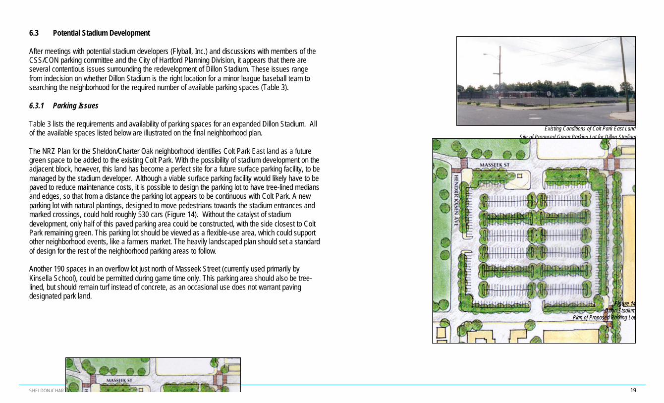
Table 3 lists the requirements and availability of parking spaces for an expanded Dillon Stadium. Allof the available spaces listed below are illustrated on the final neighborhood plan.
The NRZ Plan for the Sheldon/Charter Oak neighborhood identifies Colt Park East land as a futuregreen space to be added to the existing Colt Park. With the possibility of stadium development on theadjacent block, however, this land has become a perfect site for a future surface parking facility, to bemanaged by the stadium developer. Although a viable surface parking facility would likely have to bepaved to reduce maintenance costs, it is possible to design the parking lot to have tree-lined mediansand edges, so that from a distance the parking lot appears to be continuous with Colt Park. A newparking lot with natural plantings, designed to move pedestrians towards the stadium entrances andmarked crossings, could hold roughly 530 cars (Figure 14). Without the catalyst of stadiumdevelopment, only half of this paved parking area could be constructed, with the side closest to ColtPark remaining green. This parking lot should be viewed as a flexible-use area, which could supportother neighborhood events, like a farmers market. The heavily landscaped plan should set a standardof design for the rest of the neighborhood parking areas to follow.
Another 190 spaces in an overflow lot just north of Masseek Street (currently used primarily byKinsella School), could be permitted during game time only. This parking area should also be tree-lined, but should remain turf instead of concrete, as an occasional use does not warrant pavingdesignated park land.
Existing Conditions of Colt Park East Land Site of Proposed Green Parking Lot for Dillon Stadium
Figure 14Dillon Stadium
Plan of Proposed Parking Lot

SHELDON/CHARTER OAK NEIGHBORHOOD, HARTFORD CT 20
Scattered throughout the neighborhood, there are several underutilized parking resources whichcould be combined with the existing stadium parking with the assistance of a shuttle bus or trolleyservice. In an effort to minimize additional surface parking, other existing resources could contributeto stadium parking when simultaneous events are not scheduled (peak stadium use is expected tooccur on evenings and weekends). Parking resources like those for Kinsella School and theState/Coltsville lot generally operate at different times than the peak use hours for the new DillonStadium. In the event that the State Parking Lot could be relocated to another nearby site, the lot thatthe State rents from Coltsville could become shared parking for Coltsville residents and businesses,and stadium event attendees.
Parking for Dillon Stadium VIPs and staff could probably be designed into the stadium property itself.Some sites, such as the Batch Plant and other Huyshope Avenue properties are in disrepair, andcould be asked to share their parking resources. Generally, this approach is recommended overbuilding entirely new surface parking facilities, as the Sheldon/Charter Oak neighborhood already hasextensive surface parking facilities that are only used intermittently. In addition, there is virtuallyunlimited on street parking available on Wawarme Avenue, Locust Street and other South Meadowsstreets.
The Northeast Utilities Parking Lot is the largest undeveloped parcel of land in the Sheldon/CharterOak neighborhood. Located at the north end of Van Dyke Avenue, the Northeast Utilities site is apromising site for Riverfront related development. Although the existing parking lot could notcontribute to stadium parking without a shuttle bus or trolley system in place, the southern 20 feet ofthe Northeast Utilities site (currently a storage facility for transformers) is a promising site forRiverfront parking, with the potential to expand further. Parking is not the only option for this site, buta portion of the lot is a logical place to encourage a smaller, green parking area (as illustrated on thefinal plan).
Table 3 – Parking Requirements and Availability for Dillon StadiumDevelopment (est. 350sf/space)
Requirement for Stadium Use Number of Parking SpacesCity of Hartford 1250Stadium Developers 1700Available for Stadium UseProposed Stadium Parking Lot 533Proposed Overflow Lot 190 (estimated)On-Street Parking
Stonington Street 154 (estimated)Huyshope Avenue, Option 1 99Huyshope Avenue, Option 2(Option 1 with 98 additional game-timeparking spaces)
197
Van Dyke Avenue 88Subtotal Available 1162
(1050 south of Sequassen St, Westof Hendrickxsen Ave)
Potential Resources for Stadium Use(CSS/CON Traffic and Parking Committee,2000)Kinsella School 85BRS (State)/Coltsville Lot 200Northeast Utilities Lot 350 (with shuttle)Batch Plant (Huyshope Ave) 55Newgate Oil (Huyshope Ave) 65Construction Co. (Huyshope Ave) 155Miller’s Junk Yard (Huyshope Ave) 160Northeast Utilities (Proposed RiverfrontParking)
20
Bulkeley High School (Wethersfield Ave) 675 (estimated, with shuttle)Sub-total Resources 1660 (740 without shuttle)

SHELDON/CHARTER OAK NEIGHBORHOOD, HARTFORD CT 21
6.3.2 Traffic Flow
The Sheldon/Charter Oak neighborhood currently experiences more than adequate levels of serviceon all local streets. In order to maintain these standards during Dillon Stadium events, though,temporary traffic control measures may need to be implemented:
§ Entrance restrictions for new stadium parking - Although four parking lot entrances are possiblefor the stadium parking lot on Colt Park East, three entrances would be sufficient for the capacityand use pattern, with the logical entrance closure being along Huyshope Avenue. Periodicentrance closures are also an option, including the possibility of using only one entrance gate, butcreating one-way exits and roads to correspond with the exiting of the stadium. With that option,Curcombe and Masseek Streets between Hendrickxsen and Huyshope Avenues would becomeone-way eastbound.
§ Restricted Use Roads - Although future street closures remain a possibility, anyrecommendations for street closures would be premature until the stadium use is fully defined.Temporary closure of nearby streets, such as Masseek Street between Huyshope and Van DykeAvenues, may be useful if many community events are held at Dillon Stadium.
SHELDON/CHARTER OAK NEIGHBORHOOD, HARTFORD CT 22
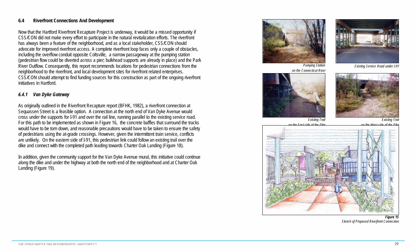
6.4 Riverfront Connections And Development
Now that the Hartford Riverfront Recapture Project is underway, it would be a missed opportunity ifCSS/CON did not make every effort to participate in the natural revitalization efforts. The riverfronthas always been a feature of the neighborhood, and as a local stakeholder, CSS/CON shouldadvocate for improved riverfront access. A complete riverfront loop faces only a couple of obstacles,including the overflow conduit opposite Coltsville, a narrow passageway at the pumping station(pedestrian flow could be diverted across a pier; bulkhead supports are already in place) and the ParkRiver Outflow. Consequently, this report recommends locations for pedestrian connections from theneighborhood to the riverfront, and local development sites for riverfront related enterprises.CSS/CON should attempt to find funding sources for this construction as part of the ongoing riverfrontinitiatives in Hartford.
6.4.1 Van Dyke Gateway
As originally outlined in the Riverfront Recapture report (BFHK, 1982), a riverfront connection atSequassen Street is a feasible option. A connection at the north end of Van Dyke Avenue wouldcross under the supports for I-91 and over the rail line, running parallel to the existing service road.For this path to be implemented as shown in Figure 16, the concrete baffles that surround the trackswould have to be torn down, and reasonable precautions would have to be taken to ensure the safetyof pedestrians using the at-grade crossings. However, given the intermittent train service, conflictsare unlikely. On the eastern side of I-91, this pedestrian link could follow an existing trail over thedike and connect with the completed path leading towards Charter Oak Landing (Figure 18).
In addition, given the community support for the Van Dyke Avenue mural, this initiative could continuealong the dike and under the highway at both the north end of the neighborhood and at Charter OakLanding (Figure 19).
Existing Trail on the East side of the Dike
Existing Trailon the West side of the Dike
Pumping Station on the Connecticut River
Existing Service Road under I-91
Figure 15Sketch of Proposed Riverfront Connection

SHELDON/CHARTER OAK NEIGHBORHOOD, HARTFORD CT 23
6.4.2 Charter Oak Landing
The existing connection between Charter Oak Landing and the Sheldon/Charter Oak neighborhoodis marginal. This connection should be improved with sidewalks that extend along Van Dyke andWawarme Avenues, and continue under the highway, as shown in the illustrated plan. As discussedin Section 5.2 above, on-street parking should also extend along both avenues, so that people canwalk to from their vehicles to events at Charter Oak Landing. Additional lighting should also beprovided, in keeping with neighborhood streetscaping efforts, to improve the aesthetics and safety ofthe underpass. If possible, the lighting standards, fixtures and street amenities that are being used aspart of Riverfront Recapture should be extended through these connections and into theneighborhood streets. This will aid in highlighting the physical proximity of the riverfront, and create acomfortable path from the riverfront walk into the neighborhood.
Figure 16Plan Detail of Northern Connection to Riverfront
Existing Connection to Charter Oak LandingFigure 17Plan Detail of Southern Connection to Riverfront

SHELDON/CHARTER OAK NEIGHBORHOOD, HARTFORD CT 24
6.4.3 Future Development Options
Several sites on the edges of the Sheldon/Charter Oak neighborhood would profit from riverfrontrelated development. Ideas for three of these sites are outlined below:
§ Restaurant Site – The Riverfront Recapture report identified a site at the edge of theneighborhood as a possible riverfront-related commercial site. This remains a viable option forneighborhood development, and is once again identified as a future initiative for CSS/CON(Figure 3).
§ Trolley Line – Although this idea has been revisited frequently in recent years, it is worthmentioning again, given the proposals for revitalizing the Sheldon/Charter Oak neighborhood.The rail line along Van Dyke Avenue could alternately be used as a trolley or streetcar line. Thiscould allow people to view the mural, or to access the neighborhood and riverfront without privatetransportation. As a trolley, it would primarily service the Sheldon/Charter Oak neighborhood onevent days or for tourism, possibly to connect outlying parking sites to Dillon Stadium or theriverfront. To increase ridership, this trolley could also run along the tracks connecting theneighborhood to Downtown Hartford.
§ BRS (State) Lot and Northeast Utilities – These sites are mentioned above as potential parkingsites for riverfront or stadium development. Another option would be to leave them for parking asan interim use, but allow the opportunity to develop them further when the neighborhood needsother services. With the redevelopment of Coltsville, future riverfront connections and the newstadium development, these two sites would be ideal for related commercial or residentialdevelopment. Other sites which could also be considered for similar development include manyof the lots south of Curcombe and Dillon Stadium, between Hendrickxsen and Van DykeAvenues.

SHELDON/CHARTER OAK NEIGHBORHOOD, HARTFORD CT 25
Figure 18Proposed Plan for the Sheldon/Charter Oak Neighborhood
N

SHELDON/CHARTER OAK NEIGHBORHOOD, HARTFORD CT 26
7.0 COST ESTIMATES
The two tables on the following pages list the preliminary cost estimates for the recommendationsmade in this report. The estimates are unit costs meant to give “order of magnitude” estimates.Detailed cost estimates will need to be developed after the NRZ chooses specific development optionsand detailed designs are developed. The preliminary cost estimates presented were developed byBFJ after conversations with City of Hartford engineers.
Table 4 shows the assumptions made for each of the unit costs. Table 5 provides an overall estimatefor each proposal. An additional 25% of the construction costs should be added to the estimatesbelow to cover soft costs (detailed design). The overall costs of the Phase I proposals can besummarized as follows:
? Huyshope Ave. improvements: $440,000? Van Dyke Avenue improvements: $150,000? Dillon Stadium Parking: $315,000? Riverfront Connections/Parking: $135,000?
8.0 APPROVALS AND FUNDING SOURCES
Major funding for implementing the recommendations of this report could come from both public andprivate sources. Public monies include the Transportation Equity Act for the 21st Century (TEA-21),which is the major federal financial source for transportation projects. This federal funding can nowbe used not only for roadway improvements but also for bicycle and pedestrian systems. Trafficcalming recommendations can also be funded through the Surface Transportation Program (STP)monies. These federal monies are controlled by the Capitol Region Council of Governments(CRCOG). It is a competitive process and CSS/CON will need to present specific applications toCRCOG.
A second major federal program is the Community Development Block Grant (CDBG), administeredthrough the federal Department of Housing and Urban Development (HUD). CDBG monies may beused for infrastructure improvements, such as streetscape plans, in areas that are income qualified.CSSCON would need to apply through the City of Hartford for this funding source.
Finally a significant component of the recommendations contained in this report relates to theRiverfront area. Riverfront Recapture Inc. has an excellent track record of raising private money andmatching it with public contributions from the Metropolitan District Commission (MDC) and the Stateof Connecticut. CSSCON should establish implementation priorities relating to the riverfront throughdiscussions with Riverfront Recapture Inc.

SHELDON/CHARTER OAK NEIGHBORHOOD, HARTFORD CT 27
Table 4 –Estimated Costs for Proposed Improvements
Amenity Distance or Amount(approximate)
Cost per unit(approximate)
EstimatedCost
Crosswalk striping 920 feet $5/linear ft $4,600New sidewalk south of Masseek St.
Huyshope Ave, west side1090 feet $25/linear ft $27,250
Huyshope Ave, east side 530 feet $13,250Van Dyke Ave 975 feet $24,375New curbing
$30/linear ft $75,000Van Dyke Ave 2500 feet
($35/linear ft with new pavers) ($87,500)
Restriping of traffic lanesHuyshope Ave 3150 feet $5/linear ft $15,750NeckdownsHuyshope Ave 12 neckdowns $15,000/neckdown $180,000Charter Oak Ave 1 neckdown $15,000Stop SignsAt the intersection of Charter Oak andHuyshope Avenues
2 stop signs $1000/stop sign $2,000
New Parking LotsDillon Stadium 536 spaces $4000/space $214,000Riverfront (NE Utilities) 20 spaces $80,000
North Riverfront CrossingUnder highway(including the cost of taking down existingwall)
210 feet $100/linear ft $21,000
Upgrade path to Riverfront 300 feet $30,000New TreesDillon Stadium Parking 68 trees in center
66 trees along perimeter$750/tree for 3”caliper trees $51,000
$49,500Van Dyke Ave south of Masseek St 24 trees $18,000Van Dyke Ave north of Masseek St 41 trees $30,750Huyshope 200 trees $150,000South Riverfront CrossingSidewalk 120 feet $25/linear ft $3,000

SHELDON/CHARTER OAK NEIGHBORHOOD, HARTFORD CT 28
Table 5 –Estimated Costs for Complete Proposals
Proposal Amenities Total Estimated CostHuyshope Avenue(Option I)
§ 13 neckdowns§ 200 trees§ 2 stop signs at Charter Oak Ave§ 18 striped crosswalks§ Extended east and west sidewalks to Wawarme Ave
$440,100
Huyshope Avenue(Option II – Same as option I withrestriped traffic lanes)
§ 13 neckdowns§ 200 trees§ 2 stop signs at Charter Oak Ave§ 18 striped crosswalks§ Extended east and west sidewalks to Wawarme Ave§ Restriped traffic lanes for on-street parking on both
sides
$455,850
Van Dyke Avenue(Option I)
§ Extended west sidewalk to Wawarme Ave§ 65 trees§ 5 striped crosswalks§ New curbing (4 ft)
$149,275
Van Dyke Avenue(Option II – Same as Option 1 witha multi-use path)
§ New curbing extended to include a paved, multiusepath (7ft)
§ Extended west sidewalk to Wawarme Ave§ 65 trees
$161,775
Stadium Parking Lot § 536 parking spaces§ Landscaped with trees and medians
$314,900
Riverfront Parking Lot onNE Utilities site
§ 20 parking spaces $80,000
Riverfront Connections § 1 striped crosswalk§ Upgraded sidewalks and paths under highway
$54,150(does not include thecost of lighting andsignage)

SHELDON/CHARTER OAK NEIGHBORHOOD, HARTFORD CT 29
APPENDIX: Stonington Street Extension Options
The connection of Stonington Street to Hendrickxsen Avenue, via the perimeter of Colt Park, is anoption that should be given consideration in conjunction with future development proposals for theneighborhood. Some of the advantages and disadvantages to this connection are described below,followed by a few examples of other projects where similar street connections have been made orproposed. It is estimated that Stonington Street connection, consisting of 900ft of new road($600/linear ft), would cost approximately $540,000. This project may be eligible for federal fundingthough the Hope VI and TEA-21 programs. The approximate route for the proposed extension isshown in Figure A3.
Advantages
§ Reconnecting the Neighborhood – At present, the homes along Curcombe Street, Hendrickxsen,Wawarme and southern Huyshope Avenues are somewhat isolated from the rest of Hartford.Connecting Stonington Street to the neighborhood better integrates the area to the rest of theCity.
§ Service and Emergency Access – A reconnected street gives multiple access points to theneighborhood which can increase accessibility by service and emergency vehicles.
§ Park Access/Safety – The reconnection of Stonington Street creates a ring road around ColtPark. This increases the visibility of park activities, an approach taken with Goodwin Park, andimproves park access for the community. This boulevard would physically connect the DutchPoint residences to the rest of the neighborhood, and would create an alternative pedestrian linkbetween Wethersfield Avenue and the Sheldon/Charter Oak neighborhood.
§ Consistency with Principles of New Urbanism – The neo-traditional or new urbanist approach tothe neighborhood seeks to reconnect and open up the neighborhood with traditional streets andsidewalks. This approach is consistent with current federal Hope VI public housing programs andwith TEA-21 funding.
Disadvantages
§ Separates Kinsella School from Colt Park – An extension of Stonington Street would separateKinsella School from Colt Park. In the event that the street is eventually connected this problemcan be mitigated by creating a neckdown an pedestrian crosswalk.
§ Increased traffic on Stonington Street – Stonington Street has relatively little traffic and isoperating well below the capacity of the street. Nevertheless, opening the street will slightlyincrease traffic.
§ Potential for increased speeds – Creating a through street could lead to slightly increasedspeeds, if traffic calming measures are not implemented simultaneously. Two appropriate trafficcalming techniques for this type of street would be neckdowns, as recommended new KinsellaSchool, and speed humps.
§ Signalized intersection at Stonington Street and Wethersfield Avenue – Subject to a City warrantstudy, the intersection of Stonington Street and Wethersfield Avenue would probably have to besignalized in the future if this extension were to be completed.
Figure A1Stonington Street
Cross Section of extended street

SHELDON/CHARTER OAK NEIGHBORHOOD, HARTFORD CT 30
Street Extension Examples
§ Imperial Ave Connector, Westport CT – The drawing below illustrates a proposed connector roadbetween downtown Westport’s Library area and an existing commuter parking lot (part of which isa proposed sire for a new YMCA).
§ Rivington Street Connector, Baruch Houses NYC – The Rivington Street Connector is a plan bythe New York City Housing Authority to reconnect old neighborhood streets through Baruchhouses.
§ Dock Street Connector, Stamford CT – This connector road has been proposed by the City ofStamford for the area just south of I-95. It’s purpose is to keep east-west traffic near I-95, and outof the south end neighborhoods.
§ Jackson Street Connector, Waterbury, CT – The Naugatuck Valley Development corporation isrequesting consultant services to develop a Conceptual Development Strategy and MunicipalDevelopment Plan (MDP) regarding a proposed connector road to link Thomaston Avenue toJackson Street in Waterbury, CT. The new Jackson Street connector would bisect an aging andpartially vacant industrial district , the Freight Street Redevelopment Area, just west of the City’sdowntown. It is envisaged that the new connector will help to revitalize the area.
§ Bronx River Road Connector, Soundview Houses NYC – At Soundview Houses in the SouthBronx, the New York City Housing Authority is discussing the reconnection of a “mapped” butunpaved street. This will provide a ring road around the existing Soundview Park, providehousing sires for new townhomes, and reconnect an existing neighborhood southeast of thedevelopment. The concept is very similar to the option for Stonington Street.
Figure A2Stonington Street
Plan detail of extended street
Figure A3Plan detail of imperial Avenue Connector
Westport, CT
Figure A4Plan detail of Rivington Street Connector
Baruch Houses, NYC

SHELDON/CHARTER OAK NEIGHBORHOOD, HARTFORD CT 31
Figure A3Proposed Plan for the Sheldon/Charter Oak Neighborhood, including an extension of Stonington Street
N

SHELDON/CHARTER OAK NEIGHBORHOOD, HARTFORD CT
HUYSHOPE AND VAN DYKE AVENUES CORRIDOR STUDY
SHELDON/CHARTER OAK NEIGHBORHOODHARTFORD, CT
JUNE 2001
Acknowledgements:
James Sequin, Chief Planner, City of Hartford
Coalition to Strengthen the Sheldon/Charter Oak NeighborhoodBoard and Economic Development Committee Members
Bernadine Silvers, PresidentLinda Osten, Vice PresidentBarbara MacGrath, Legal CounselLinda Bayer, Acting Executive DirectorPat Spring, Chair, Economic Development CommitteeEd KaeserAnthony KellerJerry Hayes
Prepared by:Buckhurst Fish and Jacquemart, Inc.
881 Broadway, 3rd FloorNew York, NY 10003
One Atlantic StreetStamford, CT 06901
In association with David Mann Associates

SHELDON/CHARTER OAK NEIGHBORHOOD, HARTFORD CT
Credits
Frank Fish, Principal in ChargeDavid Mann, Market Analysis
Anumaya Phatate, Project Manager and DesignerJoseph Cimer, Project Planner