shanghai city mhews and urban integrated observation · shanghai city mhews and urban integrated...
TRANSCRIPT
Shanghai City MHEWS and
Urban Integrated Observation
Jianguo TAN
Shanghai Institute of Meteorological Science
Shanghai Meteorological Service, CMA
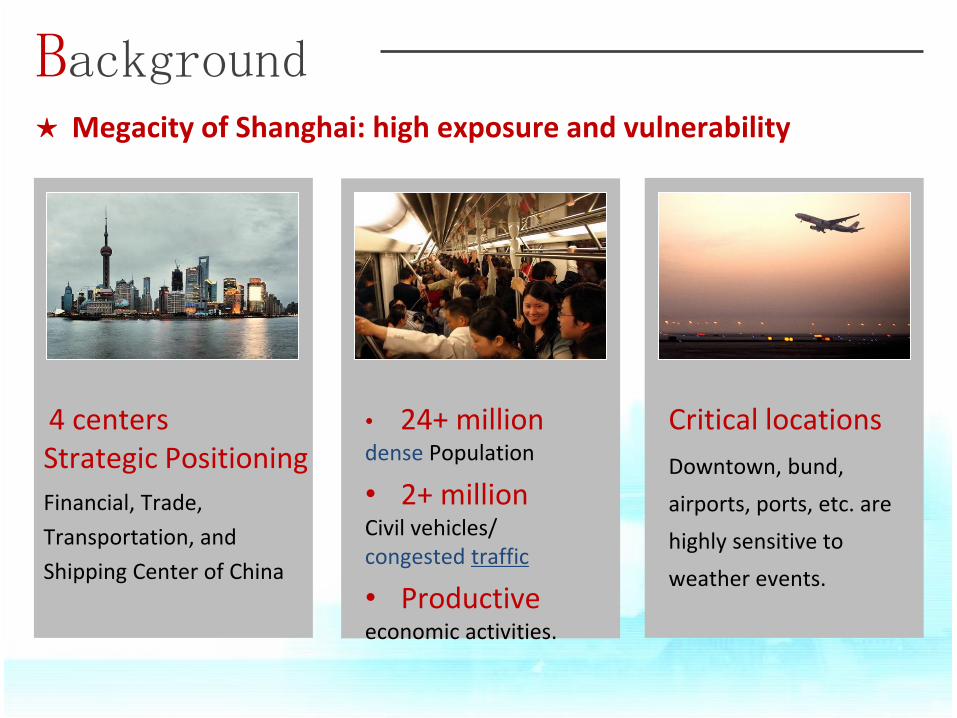
★ Megacity of Shanghai: high exposure and vulnerability
Background
4 centers Strategic Positioning
Financial, Trade,
Transportation, and
Shipping Center of China
• 24+ million dense Population
• 2+ million Civil vehicles/ congested traffic
• Productive economic activities.
Critical locations
Downtown, bund,
airports, ports, etc. are
highly sensitive to
weather events.
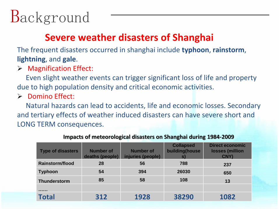
Severe weather disasters of Shanghai The frequent disasters occurred in shanghai include typhoon, rainstorm, lightning, and gale. Magnification Effect: Even slight weather events can trigger significant loss of life and property due to high population density and critical economic activities. Domino Effect: Natural hazards can lead to accidents, life and economic losses. Secondary and tertiary effects of weather induced disasters can have severe short and LONG TERM consequences.
Type of disasters Number of
deaths (people)
Number of
injuries (people)
Collapsed
building(house
s)
Direct economic
losses (million
CNY)
Rainstorm/flood 28 56 788 237
Typhoon 54 394 26030 650
Thunderstorm 85 58 108 13
……
Total 312 1928 38290 1082
Impacts of meteorological disasters on Shanghai during 1984-2009
Background
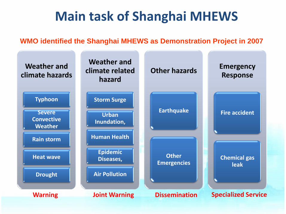
Main task of Shanghai MHEWS
Weather and climate hazards
Typhoon
Severe Convective
Weather
Rain storm
Heat wave
Drought
Weather and climate related
hazard
Storm Surge
Urban Inundation,
Human Health
Epidemic Diseases,
Air Pollution
Other hazards
Earthquake
Other Emergencies
Emergency Response
Fire accident
Chemical gas leak
Warning Joint Warning Dissemination Specialized Service
WMO identified the Shanghai MHEWS as Demonstration Project in 2007
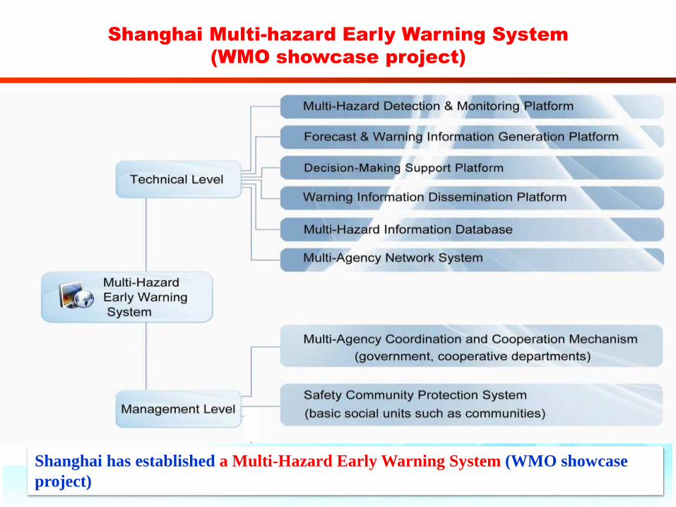
Shanghai Multi-hazard Early Warning System
(WMO showcase project)
Shanghai has established a Multi-Hazard Early Warning System (WMO showcase
project)
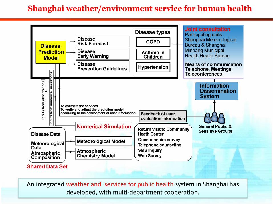
An integrated weather and services for public health system in Shanghai has developed, with multi-department cooperation.
Shanghai weather/environment service for human health
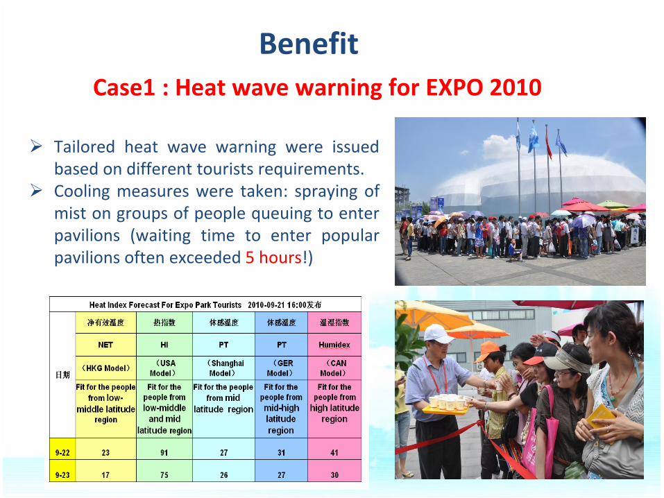
Tailored heat wave warning were issued based on different tourists requirements.
Cooling measures were taken: spraying of mist on groups of people queuing to enter pavilions (waiting time to enter popular pavilions often exceeded 5 hours!)
Case1 : Heat wave warning for EXPO 2010
Benefit
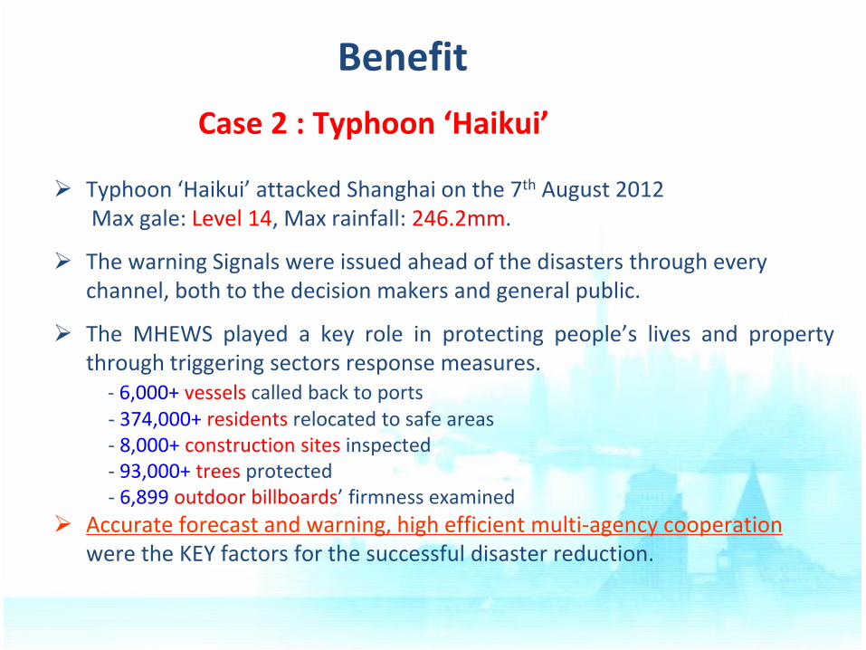
Typhoon ‘Haikui’ attacked Shanghai on the 7th August 2012 Max gale: Level 14, Max rainfall: 246.2mm.
The warning Signals were issued ahead of the disasters through every channel, both to the decision makers and general public.
The MHEWS played a key role in protecting people’s lives and property through triggering sectors response measures.
- 6,000+ vessels called back to ports - 374,000+ residents relocated to safe areas - 8,000+ construction sites inspected - 93,000+ trees protected - 6,899 outdoor billboards’ firmness examined
Accurate forecast and warning, high efficient multi-agency cooperation were the KEY factors for the successful disaster reduction.
Case 2 : Typhoon ‘Haikui’
Benefit
Challenges
Experiences
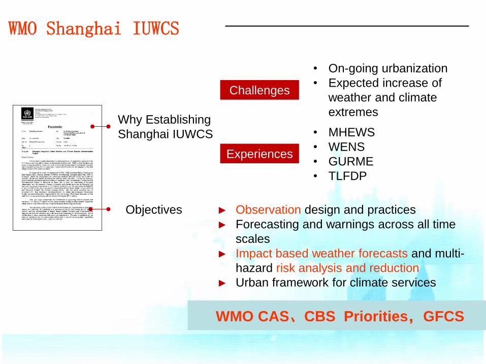
• On-going urbanization
• Expected increase of
weather and climate
extremes
• MHEWS
• WENS
• GURME
• TLFDP
► Observation design and practices
► Forecasting and warnings across all time
scales
► Impact based weather forecasts and multi-
hazard risk analysis and reduction
► Urban framework for climate services
WMO CAS、CBS Priorities,GFCS
Why Establishing
Shanghai IUWCS
Objectives
WMO Shanghai IUWCS
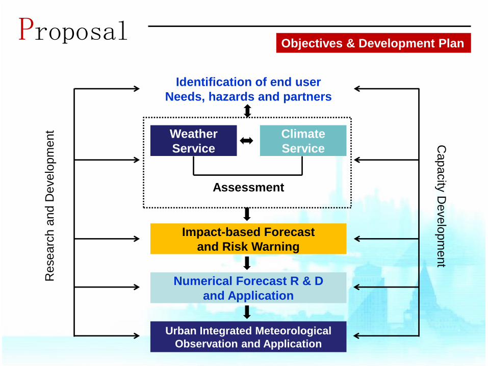
Proposal
Identification of end user
Needs, hazards and partners
Impact-based Forecast
and Risk Warning
Numerical Forecast R & D
and Application
Urban Integrated Meteorological
Observation and Application
Assessment
Weather
Service
Climate
Service
Researc
h a
nd D
evelo
pm
ent
Capacity
Develo
pm
ent
Objectives & Development Plan
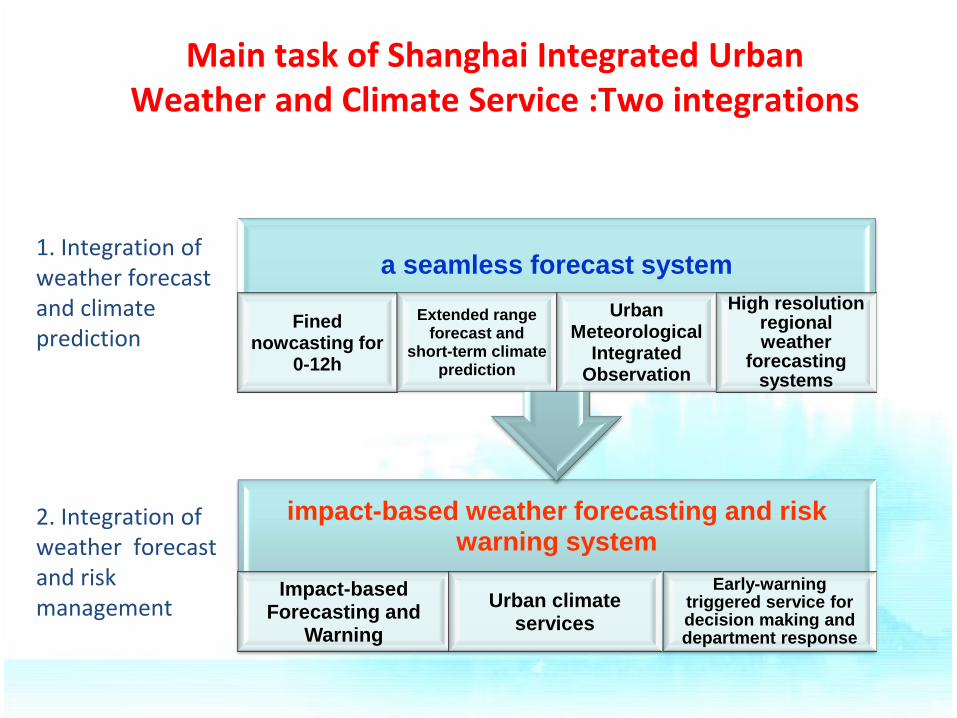
Main task of Shanghai Integrated Urban Weather and Climate Service :Two integrations
impact-based weather forecasting and risk warning system
Impact-based Forecasting and
Warning
Urban climate services
Early-warning triggered service for decision making and department response
a seamless forecast system
Fined nowcasting for
0-12h
Extended range forecast and
short-term climate prediction
Urban Meteorological
Integrated Observation
High resolution regional weather
forecasting systems
1. Integration of weather forecast and climate prediction
2. Integration of weather forecast and risk management
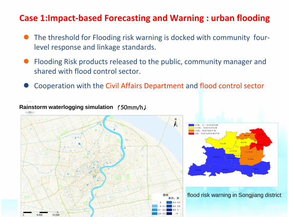
flood risk warning in Songjiang district
Case 1:Impact-based Forecasting and Warning : urban flooding
The threshold for Flooding risk warning is docked with community four-level response and linkage standards.
Flooding Risk products released to the public, community manager and shared with flood control sector.
Cooperation with the Civil Affairs Department and flood control sector
Rainstorm waterlogging simulation
health forecast in hospitals
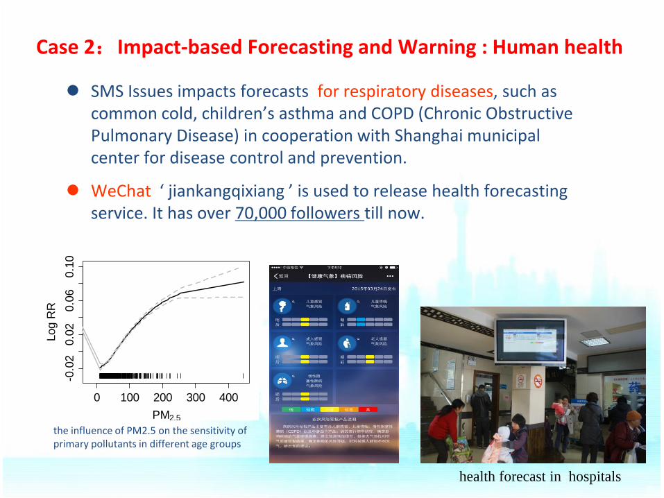
SMS Issues impacts forecasts for respiratory diseases, such as common cold, children’s asthma and COPD (Chronic Obstructive Pulmonary Disease) in cooperation with Shanghai municipal center for disease control and prevention.
WeChat ‘ jiankangqixiang ’ is used to release health forecasting service. It has over 70,000 followers till now.
Case 2:Impact-based Forecasting and Warning : Human health
0 100 200 300 400
-0.0
20.0
20.0
60.1
0
PM2.5
Log R
R
the influence of PM2.5 on the sensitivity of primary pollutants in different age groups
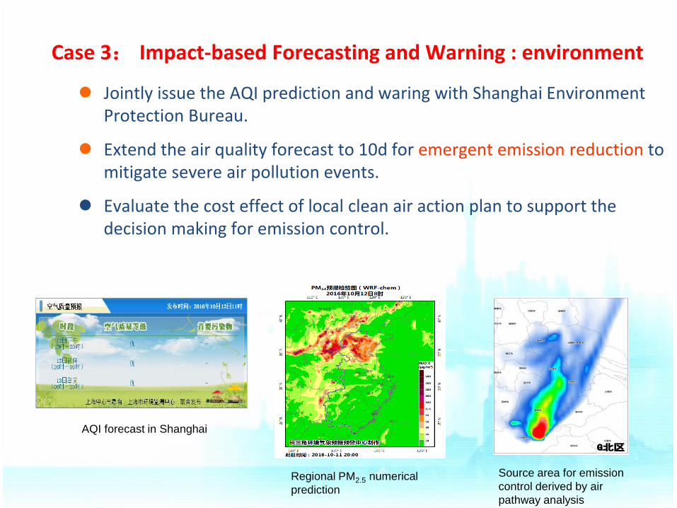
Case 3: Impact-based Forecasting and Warning : environment
Jointly issue the AQI prediction and waring with Shanghai Environment Protection Bureau.
Extend the air quality forecast to 10d for emergent emission reduction to mitigate severe air pollution events.
Evaluate the cost effect of local clean air action plan to support the decision making for emission control.
G北区 G东区 G南区
AQI forecast in Shanghai
Regional PM2.5 numerical
prediction
Source area for emission
control derived by air
pathway analysis
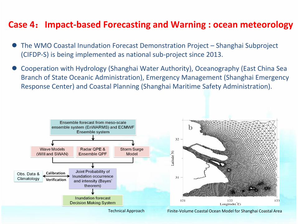
Finite-Volume Coastal Ocean Model for Shanghai Coastal Area
The WMO Coastal Inundation Forecast Demonstration Project – Shanghai Subproject (CIFDP-S) is being implemented as national sub-project since 2013.
Cooperation with Hydrology (Shanghai Water Authority), Oceanography (East China Sea Branch of State Oceanic Administration), Emergency Management (Shanghai Emergency Response Center) and Coastal Planning (Shanghai Maritime Safety Administration).
Technical Approach
Case 4:Impact-based Forecasting and Warning : ocean meteorology
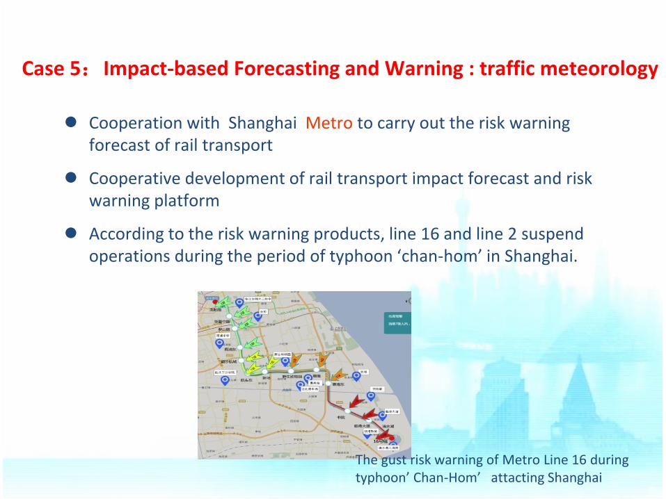
Case 5:Impact-based Forecasting and Warning : traffic meteorology
The gust risk warning of Metro Line 16 during typhoon’ Chan-Hom’ attacting Shanghai
Cooperation with Shanghai Metro to carry out the risk warning forecast of rail transport
Cooperative development of rail transport impact forecast and risk warning platform
According to the risk warning products, line 16 and line 2 suspend operations during the period of typhoon ‘chan-hom’ in Shanghai.
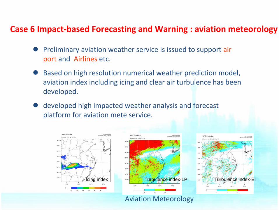
Case 6 Impact-based Forecasting and Warning : aviation meteorology
Icing index Turbulence index-LP Turbulence index-EI
Aviation Meteorology
Preliminary aviation weather service is issued to support air port and Airlines etc.
Based on high resolution numerical weather prediction model, aviation index including icing and clear air turbulence has been developed.
developed high impacted weather analysis and forecast platform for aviation mete service.
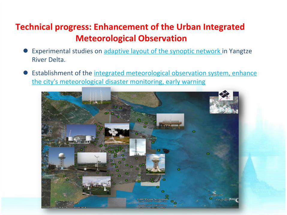
Technical progress: Enhancement of the Urban Integrated Meteorological Observation
Experimental studies on adaptive layout of the synoptic network in Yangtze River Delta.
Establishment of the integrated meteorological observation system, enhance the city's meteorological disaster monitoring, early warning
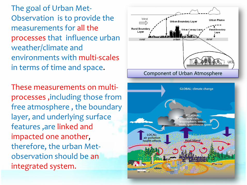
Component of Urban Atmosphere
The goal of Urban Met-Observation is to provide the measurements for all the processes that influence urban weather/climate and environments with multi-scales in terms of time and space. These measurements on multi-processes ,including those from free atmosphere , the boundary layer, and underlying surface features ,are linked and impacted one another, therefore, the urban Met-observation should be an integrated system.
1. Multi-purpose/multi-function: Weather/climate, environment forecast, Met-service, research, etc.
2. Multi-scale: macro/meso-scale, urban scale, neighbourhood scale, street, building. 3. Multi-variable: thermal, dynamic, chemical, biometeological, ecological, … 4. Multi-platforms: radar, wind profiler, photo, ground-based, aero-borne, satellite
based, in-situ observation or sampling, etc.; 5. Multi-linked: linkages between all platforms, Integration of all platforms and
techniques;
Characters of Urban Integrated observation:
Tan JG, Yang LM, Grimmond CSB, et al. Urban Integrated Meteorological Observations:
Practice and Experience in Shanghai, China , BAMS, 2015,96(1):85-102
With: • Data acquisition Management to facilitate exchange of data and information • Ability to improve coordination of strategies and instruments and to identify gaps in observations based on science- and user-driven requirements • Capability to intelligently combine observations from a variety of platforms with different models to produce the best estimate of the current state of the urban atmosphere
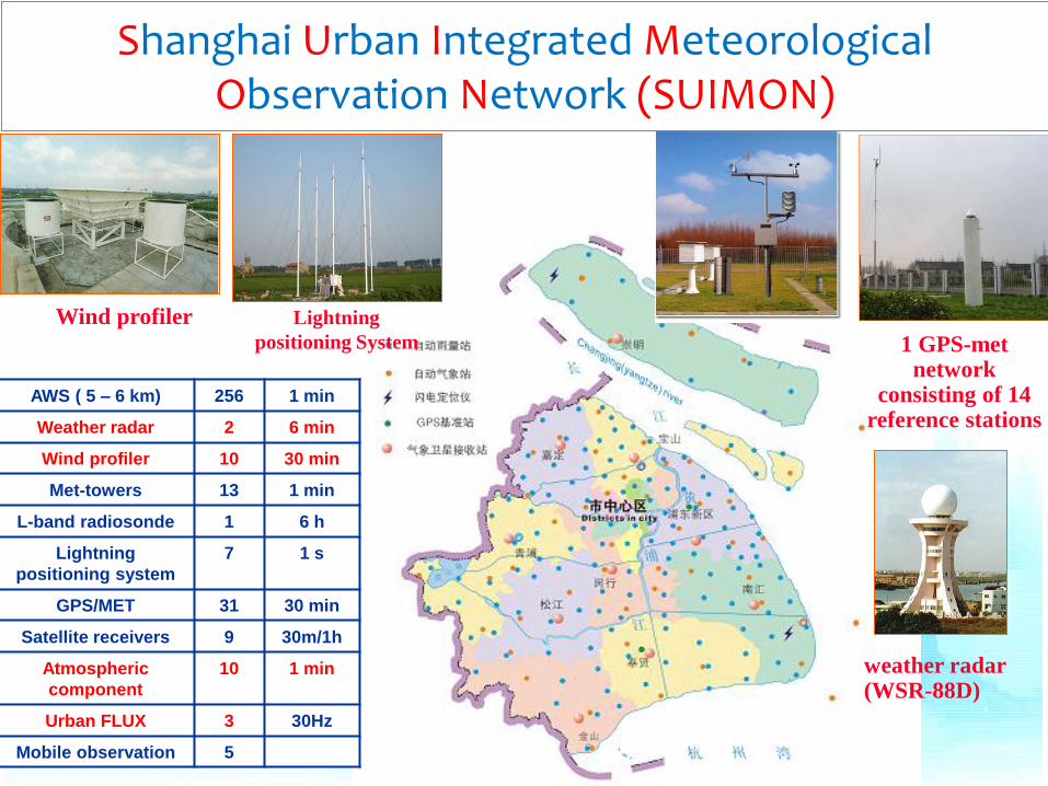
weather radar (WSR-88D)
Wind profiler Lightning
positioning System 1 GPS-met network
consisting of 14 reference stations
Shanghai Urban Integrated Meteorological Observation Network (SUIMON)
AWS ( 5 – 6 km) 256 1 min
Weather radar 2 6 min
Wind profiler 10 30 min
Met-towers 13 1 min
L-band radiosonde 1 6 h
Lightning
positioning system
7 1 s
GPS/MET 31 30 min
Satellite receivers 9 30m/1h
Atmospheric
component
10 1 min
Urban FLUX 3 30Hz
Mobile observation 5
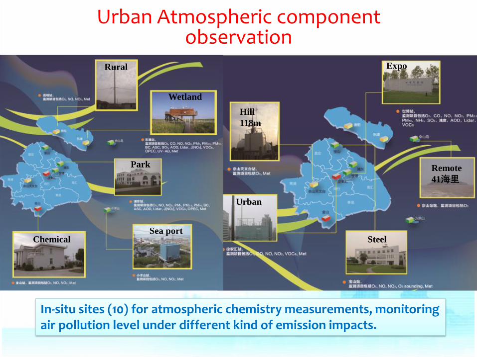
In-situ sites (10) for atmospheric chemistry measurements, monitoring air pollution level under different kind of emission impacts.
Chemical
Rural
Wetland
Urban
Park
Sea port
Hill
118m
Steel
Remote
41海里
Expo
Urban Atmospheric component observation
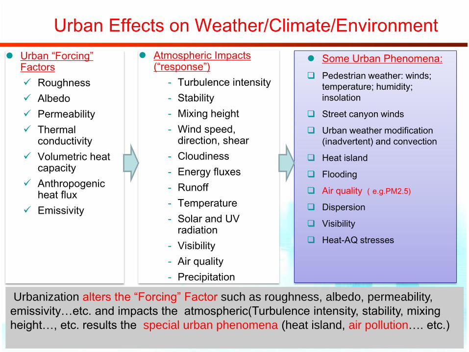
Urban Effects on Weather/Climate/Environment
Urban “Forcing” Factors
Roughness
Albedo
Permeability
Thermal conductivity
Volumetric heat capacity
Anthropogenic heat flux
Emissivity
Atmospheric Impacts (“response”)
‐ Turbulence intensity
‐ Stability
‐ Mixing height
‐ Wind speed, direction, shear
‐ Cloudiness
‐ Energy fluxes
‐ Runoff
‐ Temperature
‐ Solar and UV radiation
‐ Visibility
‐ Air quality
‐ Precipitation
Some Urban Phenomena:
Pedestrian weather: winds;
temperature; humidity;
insolation
Street canyon winds
Urban weather modification
(inadvertent) and convection
Heat island
Flooding
Air quality (e.g.PM2.5)
Dispersion
Visibility
Heat-AQ stresses
Urbanization alters the “Forcing” Factor such as roughness, albedo, permeability,
emissivity…etc. and impacts the atmospheric(Turbulence intensity, stability, mixing
height…, etc. results the special urban phenomena (heat island, air pollution…. etc.)
• Surface/in situ observation
• Met Tower
• Ground-based Remote sensing( weather radar, Wind Profile, RASS, Sodar, Lidar)
• Aeroborne sample/remote sensing
• satellite based remote sensing
• Wind Tunnel. water tank experiment ….
Multi-platform
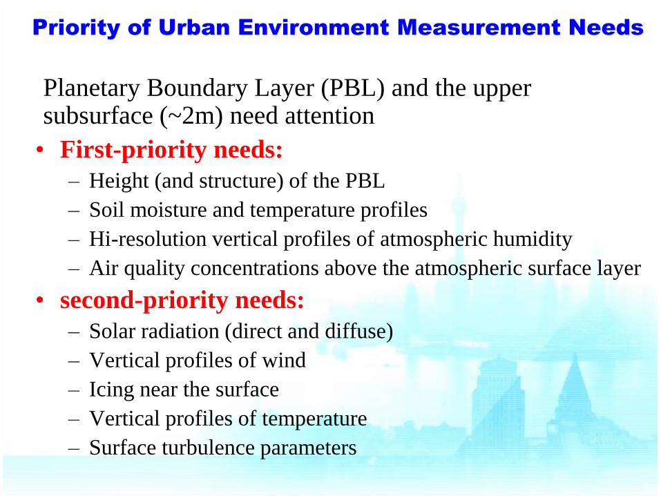
Priority of Urban Environment Measurement Needs
Planetary Boundary Layer (PBL) and the upper subsurface (~2m) need attention
• First-priority needs:
– Height (and structure) of the PBL
– Soil moisture and temperature profiles
– Hi-resolution vertical profiles of atmospheric humidity
– Air quality concentrations above the atmospheric surface layer
• second-priority needs:
– Solar radiation (direct and diffuse)
– Vertical profiles of wind
– Icing near the surface
– Vertical profiles of temperature
– Surface turbulence parameters
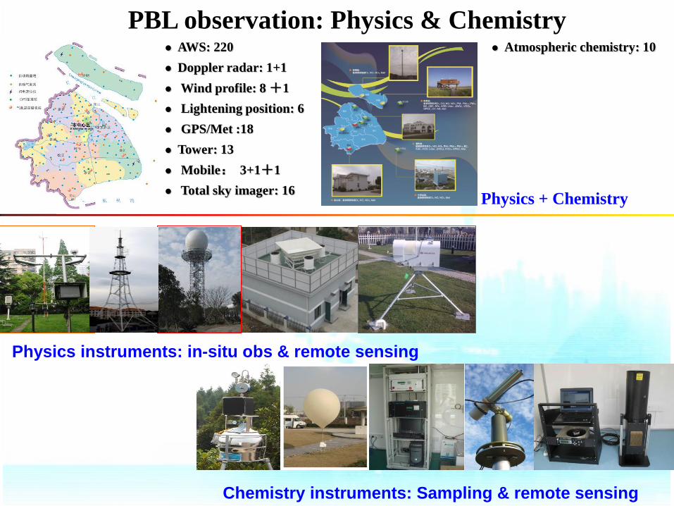
AWS: 220
Doppler radar: 1+1
Wind profile: 8 +1
Lightening position: 6
GPS/Met :18
Tower: 13
Mobile: 3+1+1
Total sky imager: 16
PBL observation: Physics & Chemistry Atmospheric chemistry: 10
Physics instruments: in-situ obs & remote sensing
Chemistry instruments: Sampling & remote sensing
Physics + Chemistry
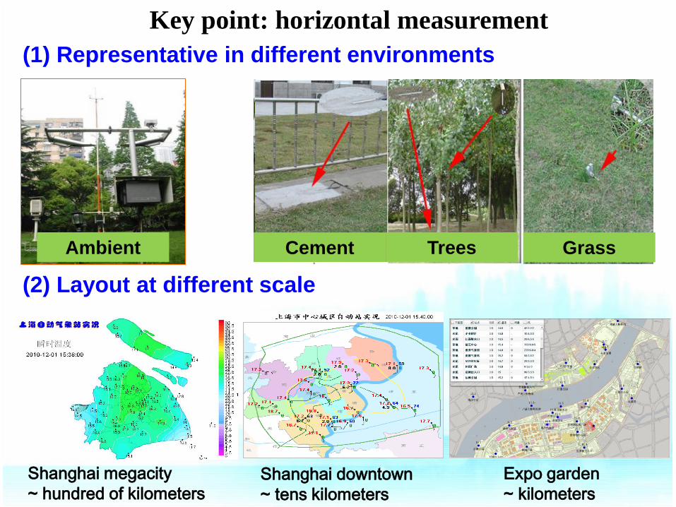
Shanghai megacity
~ hundred of kilometers Shanghai downtown
~ tens kilometers
Expo garden
~ kilometers
Cement Trees Grass Ambient
Key point: horizontal measurement
(1) Representative in different environments
(2) Layout at different scale
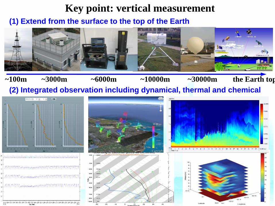
Key point: vertical measurement
~100m ~3000m ~10000m ~30000m the Earth top ~6000m
(1) Extend from the surface to the top of the Earth
(2) Integrated observation including dynamical, thermal and chemical
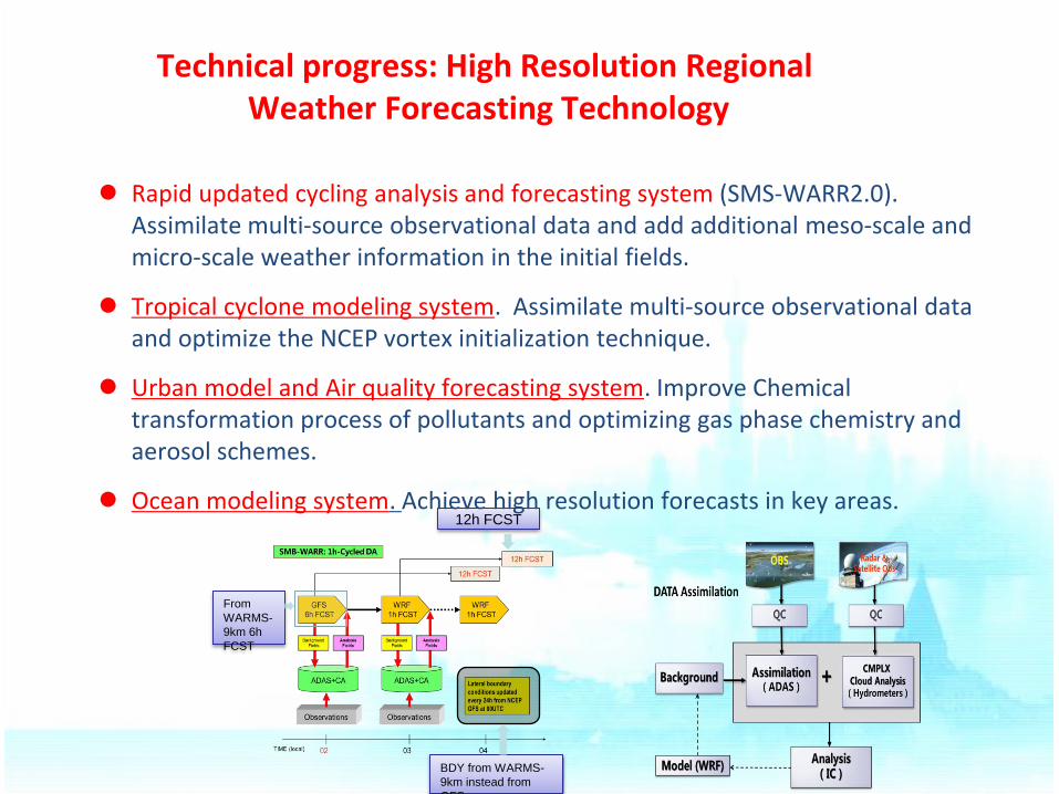
Technical progress: High Resolution Regional Weather Forecasting Technology
From
WARMS-
9km 6h
FCST
12h FCST
BDY from WARMS-
9km instead from
GFS
Rapid updated cycling analysis and forecasting system (SMS-WARR2.0). Assimilate multi-source observational data and add additional meso-scale and micro-scale weather information in the initial fields.
Tropical cyclone modeling system. Assimilate multi-source observational data and optimize the NCEP vortex initialization technique.
Urban model and Air quality forecasting system. Improve Chemical transformation process of pollutants and optimizing gas phase chemistry and aerosol schemes.
Ocean modeling system. Achieve high resolution forecasts in key areas.
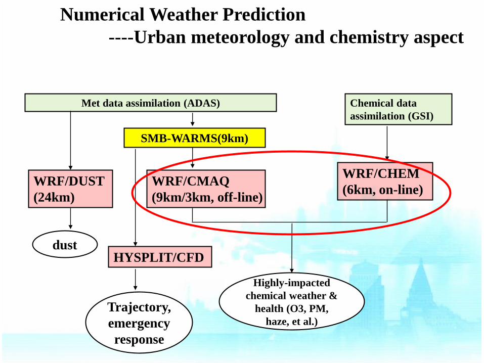
SMB-WARMS(9km)
WRF/CHEM
(6km, on-line)
HYSPLIT/CFD
WRF/DUST
(24km)
Met data assimilation (ADAS)
Highly-impacted
chemical weather &
health (O3, PM,
haze, et al.)
dust
Trajectory,
emergency
response
Chemical data
assimilation (GSI)
WRF/CMAQ
(9km/3km, off-line)
Numerical Weather Prediction
----Urban meteorology and chemistry aspect
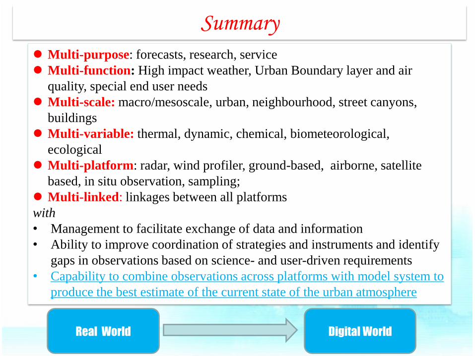
Summary
Multi-purpose: forecasts, research, service
Multi-function: High impact weather, Urban Boundary layer and air
quality, special end user needs
Multi-scale: macro/mesoscale, urban, neighbourhood, street canyons,
buildings
Multi-variable: thermal, dynamic, chemical, biometeorological,
ecological
Multi-platform: radar, wind profiler, ground-based, airborne, satellite
based, in situ observation, sampling;
Multi-linked: linkages between all platforms
with
• Management to facilitate exchange of data and information
• Ability to improve coordination of strategies and instruments and identify
gaps in observations based on science- and user-driven requirements
• Capability to combine observations across platforms with model system to
produce the best estimate of the current state of the urban atmosphere
Real World Digital World

Thank you for your attention!