sh1 peka peka to north otaki expressway: draft urban and landscape design framework ·...
TRANSCRIPT

Peka Peka to North Otaki Expressway ProjectDRAFT Urban and Landscape Design Framework
Opus International Consultants LtdMarch 2013

Prepared by: Tessa Cox, Landscape Architect
Internally Reviewed by: Bruce Curtain, Principal Architect David McKenzie, Principal Landscape Architect
Externally Reviewed by: Chris McDonald, Architect and Urban Designer
Opus International Consultants LimitedWellington OfficeLevel 7, Majestic Centre100 Willis Street, PO Box 12-003Wellington, New Zealand
Telephone: +64 4 471 7000Facsimile: +64 4 471 1397
Reference: 5C1814.00
Revision Schedule
Rev No. Date Description Prepared by Reviewed by Approved by
1 Nov 2010 First Draft for Scoping Report Tessa Cox Bruce Curtain, David McKenzie and Chris McDonald Tony Coulman
2 Feb 2011 Second Draft for Scoping Report Tessa Cox Bruce Curtain and David McKenzie Tony Coulman
3 Sept 2011 Third Draft for SARA Tessa Cox Bruce Curtain and David McKenzie Gareth McKay
4 Feb 2012 Fourth Draft for SARA Tessa Cox Bruce Curtain Gareth McKay
5 Oct 2012 Fifth Draft for AEE Tessa Cox Bruce Curtain, David McKenzie, Mark Edwards Adam Nicholls
6 Mar 2013 Sixth Draft for AEE Tessa Cox Adam Nicholls Adam Nicholls
This report has been prepared for the benefit of the NZ Transport Agency (NZTA). No liability is accepted by this company or any employee or sub-consultant of this company with respect to its use by any other person. This disclaimer shall apply notwithstanding that the report may be made available to other persons for an application for permission or approval or to fulfil a legal requirement.

Peka Peka to North Otaki Expressway Project- Urban and Landscape Design Framework - Opus International Consultants Ltd - DRAFT March 2013
Section 1 Introduction
1.1 Project overview .................................................................... Page 11.2 Purpose of the ULDF ........................................................... Page 41.3 Methodology and structure of the ULDF ............. Page 41.4 Route description ................................................................... Page 51.5 Project benefits ........................................................................ Page 91.6 Urban design issues ............................................................ Page 121.7 Landscape and visual issues ........................................ Page 15
Section 2Policy context
2.1 Policy introduction ................................................................... Page 172.2 Planning policy ......................................................................... Page 172.3 Transport policy ........................................................................ Page 21
Section 3Corridor - urban and rural context
3.1 Introduction ........................................................... Page 253.2 Landform ................................................................ Page 253.3 Hydrology .............................................................. Page 283.4 Vegetation and ecology .............................. Page 303.5 Land uses ............................................................. Page 353.6 Character areas .................................................. Page 373.7 Tangata whenua and heritage .............. Page 393.8 Community facilities ...................................... Page 413.9 Movement networks .................................. Page 433.10 Community consultation ........................... Page 47
Contents
Section 4Corridor design
4.1 Overarching principles .......................................................... Page 494.2 Corridor-wide design principles ................................... Page 51 4.2.1 Landscape ....................................................... Page 51 4.2.2 Earthworks ...................................................... Page 54 4.2.3 Structures ......................................................... Page 55 4.2.4 Noise mitigation .......................................... Page 61 4.2.5 Pedestrian, cycle & bridleway links Page 62 4.2.6 Road furniture .............................................. Page 63 4.2.7 Stormwater ...................................................... Page 64
Section 5Sector design
5.1 Peka Peka to Mary Crest ..................................................... Page 675.2 Te Horo ............................................................................................. Page 69 5.3 Otaki .................................................................................................... Page 735.4 Otaki Railway Retail Area ....................................................... Page 79
Appendix A: Landscape drawings (for consenting)
Appendix B: District Plan maps
References


Section 1. Introduction

Peka Peka to North Otaki Expressway Project- Urban and Landscape Design Framework - Opus International Consultants Ltd - DRAFT March 2013
1.1 Project overview
Figure 1.Context of the Project
Expressway alignment
The Wellington Northern Corridor Roads of National Significance (RoNS) runs from Wellington International Airport to Levin and completing it will assist Regional and national economic growth. The Peka Peka to North Otaki Project (the Project) is one of eight sections of the Wellington Northern Corridor which has been identified by the Government as a RoNS. The location of the Project within this wider corridor is shown in Figure 1. The Peka Peka to North Otaki Project is the subject of this Urban and Landscape Design Framework (ULDF).
The Kapiti Expressway comprises three sections of the Wellington Northern Corridor – namely MacKays to Peka Peka, Peka Peka to Otaki and Otaki to Levin. The New Zealand Transport Agency (NZTA) proposes to designate land and obtain the resource consents to construct, operate and maintain the Peka Peka to North Otaki section of the Kapiti Expressway. This Project extends from Te Kowhai Road in the south to Taylors Road just north of Otaki, an approximate distance of 12.2km (Refer to Figure 2).
The Peka Peka to Otaki section of the Kapiti Expressway will provide an Expressway
with two lanes of traffic in each direction. Connections to existing local roads, new local roads and access points over the Expressway to maintain safe connectivity between the western and eastern sides of the Expressway are also proposed as part of the Project. There is an additional crossing of the Otaki River proposed as part of the Project, along with crossings of other watercourses throughout the Project length.
On completion, it is proposed that the Expressway become State Highway 1 (SH1) and that the existing SH1 between Peka Peka and Otaki will become a local arterial road, allowing for the separation of local and through traffic. In this document, the existing SH1 will be referred to as the 'local arterial,' or 'former SH1.'
SH1 Revocation
Although the SH1 Revocation is not addressed as part of this Project, some ideas and opportunities for the revocation Project will be suggested throughout this ULDF document.
1.

Peka Peka to North Otaki Expressway Project- Urban and Landscape Design Framework - Opus International Consultants Ltd - DRAFT March 2013
NZTA Project objectives
The overall Project objectives for NZTA can be summarised within the following statement:
“To provide a modern 4-lane Expressway that will support economic development by providing a strategic arterial route to improve trip reliability and efficiency through the Wellington Region. The Project will provide legible connections to Otaki Township, and provide for community connections across the corridor. The Expressway is to be integrated with the Otaki Vision and opportunities to enhance urban and landscape outcomes, are to be explored.”
Sitting above the Project objectives are a set of Wellington Northern Corridor RoNS-wide RMA objectives, and Peka Peka to North Otaki Expressway Project objectives, which are shown in Table 1 below.
The key project-specific objectives for the Peka Peka to Otaki Project are to:
• Enhance inter-regional and national economic growth and productivity;
• Enhance efficiency and journey time
reliability from, to and through the Kapiti District, Wellington’s Central Business District, key industrial and employment centres, the port, airport and hospital;
• Enhance safety of travel on SH1;
• Appropriately balance the competing functional performance requirements of inter-regional and local traffic movements, and to facilitate others to provide modal choice opportunities, to enable local facilities and amenities in the Kapiti Coast District to be efficiently accessed;
• Manage the immediate and long-term social, cultural, land use and other environmental effects of the Project on the Kapiti Coast District and its communities by so far as reasonably practicable avoiding, remedying or mitigating any adverse effects through route and alignment selection, Expressway design and conditions;
• Integrate the Expressway into the form of Kapiti Coast District by taking into account current and planned
future land use and development in route and alignment selection, Expressway design and conditions;
• Work with NZ Rail Corporation Ltd/KiwiRail Ltd to achieve an integrated design for both the Expressway and a realigned NIMT railway; and
• To efficiently serve Otaki and its future development by providing appropriate vehicle access and signage to and from the new Expressway.
NZTA’s urban and landscape design related priorities for the Expressway include:
• Developing an integrated solution that achieves an appropriate balance between the functional performance requirements of local and State highway traffic; and
• Addressing social, land use and environmental effects of the Project in the context of the aspirations of territorial authorities.
The Project creates the opportunity to improve connections and networks and have a positive effect on the urban form
of Otaki and Te Horo. However, failure to properly consider the way in which Otaki and Te Horo have developed, and could develop in future, may result in infrastructure that leads to poor urban form and negative community outcomes.
Urban design is therefore one of the primary considerations for the Project. Its importance is recognised by our key stakeholders and local community.
These include:•NZTA(directclient);•KapitiCoastDistrictCouncil;•GreaterWellingtonRegionalCouncil;•KiwiRail;•Localcommunity;•Localiwi;and•UsersofSH1andNIMTrailwaycorridor.
Terms
In this document, 'the Project' refers to:• Construction, operation and maintenance of the main Expressway alignment;• Realignment of part of the NIMT railway; and• Construction and operation of associated local road connections.
In this document, when discussing the Project proposal, the existing SH1 will be referred to as 'former SH1' or 'local arterial.'

Peka Peka to North Otaki Expressway Project- Urban and Landscape Design Framework - Opus International Consultants Ltd - DRAFT March 2013
GPS Wellington Northern RoNS Peka Peka to North Otaki
Support economic growth
To enhance inter-Regional and national economic growth and productivity.
To improve access to Wellington’s CBD, key industrial and employment centres, port, airport and hospital.
By: Providing a significantly improved transport link as an integral part of the Wellington Northern Corridor RoNS.
By: Achieving a State highway to Expressway standards that connects with the Mackays to Peka Peka and North Otaki to Levin sections of the Wellington Northern Corridor RoNS; andEfficiently serving the Otaki Township, its future development and the wider Otaki area.
Reduce congestion
To provide relief from severe congestion on the State highway and local road networks.
To improve the journey time reliability of travel on the section of SH1 between Levin and the Wellington Airport.
By: Aligning traffic types and movements with the most appropriate route by separating through traffic from local traffic.
Improve safety To improve the safety of travel on State highways.
By: Separating Regional and local traffic, limiting access to the Expressway and providing local grade separated access across the Expressway at Te Horo.
Table 1. NZTA's objectives for the Wellington Northern Corridor RoNS and the Peka Peka to North Otaki Project
3.

Peka Peka to North Otaki Expressway Project- Urban and Landscape Design Framework - Opus International Consultants Ltd - DRAFT March 2013
1.3 Methodology and structure of the ULDF
1.2 Purpose of the ULDF
The Project's ULDF is a document prepared to demonstrate how the Peka Peka to North Otaki Project fulfils NZTA's Urban Design policy requirements (see Section 2). However, the overall purpose of the ULDF is to ensure that the urban and landscape design concepts of the Project are appropriately defined, developed and implemented.
This document is intended for use as a guiding tool for the Project consultants and engineers from concept through to detailed design. The ULDF should be included with the detailed design package, so that the construction team is also aware of the objectives and guiding principles of the Project.
The ULDF is developed in accordance with NZTA guidelines and supports the Notice of Requirement application.
The ULDF seeks to establish a balance between RoNS network objectives, the desired future for Otaki as outlined in the Otaki Vision document (2007), and the specific urban and landscape context of the Expressway corridor.
The ULDF is not an assessment of effects of the Project to satisfy the requirements
of the Resources Management Act (1991). A separate Landscape and Visual Effects Assessment and an Urban Design Effects Assessment have been carried out for RMA purposes.
Throughout the ULDF, images have been used to assist communication of the design features of the Project. It is noted that these are typically diagramatic or conceptual.
The ULDF is a product of urban and landscape design investigations of the Project Area, Project team meetings, numerous multidisciplinary workshops, Wellington RoNS urban design workshops, and liaison with stakeholders.
The study methodology is reflected in the ULDF structure, shown below:
Section 1. Introduction
Introducing the ULDF document, by outlining the purpose of the ULDF, the structure / methodology of the document, and defining the smaller study sectors within the Project extent (Peka Peka to Mary Crest, Te Horo, Otaki Township, and Otaki Railway Retail Area).
Section 2. Policy context
Outlining additional influences and considerations which affect the Project. This includes the NZ Urban Design Protocol, and the objectives outlined in the Otaki Vision document provided by KCDC.
Section 3. Corridor - urban and rural context
Analysis of the existing highway corridor, identifying built, environmental and social constraints and opportunities. This includes:• Multidisciplinary specialist inputs;• Information gathered from site visits;• View analysis to ensure familiarity
with the route; and• A cohesive and integrated urban
and landscape design vision for the highway corridor, and confirmation of key site parameters affecting the design development.
Section 4. Corridor design
Development of a cohesive set of urban and landscape design principles for the Expressway, which reflect the route investigations in Section 3 of this document, as well as NZTA’s objectives for the Expressway and the objectives of the stakeholders.
These urban and landscape design principles have been broken into numerous elements including: landscape, earthworks, structures, noise barriers,
pedestrian, cycle and bridleway links, planting, road furniture, and stormwater.
Section 5. Sector design
Studying the smaller study sectors within the Project extents in more detail, and identifying the design principles specific to the issues and existing characteristics of the smaller sectors.

Peka Peka to North Otaki Expressway Project- Urban and Landscape Design Framework - Opus International Consultants Ltd - DRAFT March 2013
1.4 Route description
The Project Area is located along the Kapiti Coast, approximately 70km north of Wellington. The route stretches for 12.2km from Te Kowhai Road in the south to Taylors Road in the north and bisects Otaki Township.
The Project Area comprises a mix of land uses including rural, residential, industrial, commercial and horticultural.
The route passes through two Townships; Te Horo, a small community of approximately 640 people, and Otaki, a larger town of approximately 5,600. Otaki is the northernmost urban centre of the Kapiti Coast District and the Wellington Region.
The Project traverses relatively flat terrain, crossing the Mangaone Stream, the Otaki River, the Mangapouri Stream, the Waitohu Stream and the NIMT railway line.
The SH1 currently has priority over all intersections along the route, with the exception of the roundabout at Mill Road and Rahui Road in Otaki Township. Significant traffic congestion issues are experienced at this roundabout, particularly during busy periods.
The NIMT railway and the existing SH1 creates severance effects for the east-west connectivity in Te Horo and Otaki.
In Otaki as there is only one main east-west connection (Mill Road / Rahui Road) providing access across the transport corridor.
A description of the key urban design issues along the route are summarised in Section 1.6 of this document.
Alternative routes considered
The classification of the route as a RoNS highlights the importance of the Expressway not only at a regional scale, but also at a national scale. The route has been the subject of numerous investigations and studies over many years and several consultation stages with stakeholders and the wider public have been undertaken.
Studies undertaken in 2008 and 2009 reviewed options relating to the central route and endorsed it as the preferred route. This was adopted by the NZTA board in December 2009, subject to a range of ongoing reviews and detailed investigations.
Throughout the development of the current Project, including as a result of public consultation, there have been a range of route options put forward for further consideration and assessment. The corridors that were considered in most detail are:
• Eastern Foothills route – this route extends from the Peka Peka interchange in the south, then follows the foothills up to 2.7km east of the existing SH1 and Otaki Township, before swinging back to join SH1 at Manakau.
• Eastern Plains route – which is situated between the central and eastern foothills options, joining the ‘central route’ just north of Te Horo;
• Western route – being generally located between the coast and the existing SH1; and
• Central route – that roughly follows the existing SH1/NIMT railway corridor and forms the route on which the Project is based.
East-west connectivity
The retention and enhancement of connectivity across (i.e. east–west) the north-south Expressway and rail corridors has also been a key urban design consideration throughout the Project development. Corridor severance effects are an issue with the existing SH1 and NIMT rail corridors and could be further increased with the implementation of the Expressway. Investigations were undertaken to identify where these effects currently occur, which east-west connectivity locations were critical through community desire lines.
Since 2010, a number of east-west connectivity options have been investigated including at Rahui Road, Waerenga Road, Old Hautere Road and Te Horo.
Currently Rahui Road connects to the SH1/Mill Road roundabout and crosses the NIMT railway at grade. Any new connectivity at Rahui Road would need to cross over both the Expressway and realigned NIMT railway (now running parallel to each other). A number of options were considered including:
• Not recreating a link and relying solely on the North Otaki Interchange for connectivity;
• A pedestrian only footbridge or underpass at Rahui Road; and
• A grade-separated structure allowing full vehicle and movement at Rahui Road.
The first round of public consultation feedback clearly highlighted a strong need for a full vehicle connection at Rahui Road.
Refer to the AEE Urban Design Assessment for more detail on east-west connectivity options which were considered throughout the design process, and why these options were or were not taken forward.
5.
Terms
In this document, 'the Project Area' is the broad visual catchment of Expressway and encompasses that which can be seen from either SH1 as this is the consistent 'viewpoint' from which the Expressway has been considered.

Peka Peka to North Otaki Expressway Project- Urban and Landscape Design Framework - Opus International Consultants Ltd - DRAFT March 2013
PEKA PEKA
TE HORO
OTAKI
Otaki River
Waitohu Stream
Mangaone Stream
Mangapouri Stream
Figure 2.Site extents for Peka Peka to North Otaki Expressway
(Te Kowhai Rd to Taylors Rd) Sc
hool
RdRahui RdTO LEVIN TO WELLINGTON
MARY CRESTTe Horo Beach Rd
Te Waka Rd
Old Hautere Rd
Otak
i Gor
ge R
d
Rive
rban
k R
d
Gear Rd
Existing SH 1
Mill
Rd
Peka Peka Rd
Taylo
rs R
d
Wae
reng
a Rd
Te Kowhai Rd

Peka Peka to North Otaki Expressway Project- Urban and Landscape Design Framework - Opus International Consultants Ltd - DRAFT March 2013
Project sectors
Refer to Sections 3.5, 3.6 and 5 for further descriptions of the Project sectors.
Within the Project extents, the site can be divided into four main sectors: Peka Peka to Mary Crest, Te Horo, Otaki Township, and Otaki Railway Retail Area (which sits within Otaki Township along the existing SH1). Refer to Figure 3.
Peka Peka to Mary CrestPeka Peka to Mary Crest is a section of the Project Area, predominantly of rural character, with the occasional lifestyle property evident.
Te HoroTe Horo is a small rural community located toward the southern end of the Project Area. The urban form is a simple linear development, with the main community functions structured along School Road, and market garden stalls on SH1. These areas are severed by both the existing SH1 and rail corridors.
Otaki TownshipOtaki Township is the northernmost centre of three dominant settlements on
the Kapiti Coast. The urban boundaries of Otaki are the Otaki River to the south and the Waitohu Stream to the north.
The majority of Otaki residents and community amenities are located west of the SH1 corridor with a smaller residential population to the north west on the Waitohu Plateau. The key connections between the two areas are via the existing SH1 and Rahui Road.
The area surrounding Otaki Township is predominantly rural, with the Otaki economy relying largely on farming and horticulture.
Otaki Railway Retail AreaThe Otaki Railway Retail Area is located along the existing SH1 within the Project sector of Otaki Township in the form of a specialist and outlet retail strip (between Waerenga Road and the roundabout at SH1/Mill Road intersection).
The economic viability of the businesses in this area would be particularly sensitive to the form and legibility of off and on ramps to Otaki from the Expressway.
The natural centre of the Railway Retail
Area is the Arthur Street intersection which acts as a minor east-west axis perpendicular to the existing SH1.
North Island Main Trunk (NIMT) Railway
KiwiRail proposes to designate land in the Kapiti Coast District Plan for the construction, operation and maintenance of a re-aligned section of the NIMT railway through Otaki.
The realignment of the NIMT railway is to facilitate the Expressway, however at the same time the realignment addresses many safety issues with the removal of several at-grade crossings.
Current State Highway 1 (to become local arterial)
As part of the Project, a section of the current SH1 at Mary Crest is required to the relocated. In effect, a new section will be built in the western side of the Expressway, connecting to the existing SH1 south of the Project.
As stated, the Expressway allows for the
existing SH1 between Peka Peka and North Otaki to become a local arterial road that is safe and efficient for use by the local community. The local arterial users will be separated from State highway traffic that is passing through.
With appropriate linkages and crossings to enable connectivity between either side of the Expressway, the local arterial road will provide a functional route for local traffic and will form part of an integrated network.
Although this Project includes linkages to the local arterial (and other local roads), and the construction of a new section of local arterial road to replace that built over by the Expressway, any redevelopment of the former SH1 itself does not form part of this Project. Revocation of this road will be undertaken in the future and any required approvals sought at that time.
Although the Project does not preclude the construction of parallel walking and cycling facilities along the local arterial road, they are not part of this Project.
These will be addressed through the SH1 Revocation process, whereby the section
of local arterial road no longer required as State highway is transferred to Kapiti Coast District Council (KCDC). Final decisions on the form of the local arterial and any re-development of this are not yet made, however high level principals have been agreed between NZTA and KCDC. These principals will be used, in conjunction with KCDC, to refine the re-development requirements for the local arterial.
7.

Peka Peka to North Otaki Expressway Project- Urban and Landscape Design Framework - Opus International Consultants Ltd - DRAFT March 2013
MARY CRESTTE HOROOTAKI
Otaki River
Waitohu Stream
Mangaone Stream
Mangapouri Stream
Figure 3.Location of Project sectors
Key:1. Peka Peka to Mary Crest2. Te Horo3. Otaki Township4. Otaki Railway Retail Area
PEKA PEKA
3.
4.
2.
1.
0km 1 2 3 4 4.5
Indicative Expressway locationExisting SH1
NIMT railwayLocal connections
Retail/commercial areaIndustrial area
Residential areaStream/waterway
Green space / recreation spaceSchool
Commercial horticultureEcological heritage area
Clusters of localised vegetationOtaki River flood plain extents
Western foothills of the Tararua Ranges
MARY CREST

Peka Peka to North Otaki Expressway Project- Urban and Landscape Design Framework - Opus International Consultants Ltd - DRAFT March 2013
Need for the Project
The importance of improvement of the State highway network throughout the Kapiti District has been identified by a number of studies. There are a number of issues that the District faces including:• Access, congestion and reliability;• Safety;• Population growth;• Route security;• Freight movement; and• Amenity and social effects, including
walking and cycling.
The focus of the State highway network is on moving people and freight between and within the main centres of New Zealand as safely and efficiently as possible. The local network and community objectives and needs are also important in considering the need for the Project given the function that SH1 currently provides. The Project therefore is required to achieve an integrated network that also facilitates local trips and modal choice.
Access, congestion and reliabilityAs it stands, the existing SH1 through the Kapiti Coast is a key transportation link to and from Wellington City.
The main problem with the existing SH1 through the Project Area is the severe congestion caused at peak periods, especially at weekends and over public holidays, and in particular through Otaki.
The State highway provides for both local and through traffic and includes uses for commuting, business and recreational purposes. The combined servicing of both local and through traffic further exacerbates congestion issues. Adding to this problem, there will be increased pressures placed on this network as population numbers increase.
Implementation of the Project provides an opportunity for traffic congestion relief and the separation of regional and local traffic by providing an effective local road alternative and an integrated network.
The lack of a parallel local road in the current State highway network between Peka Peka and North Otaki has effects on reliability. Any obstruction to the traffic flows has effects on both local and
through traffic as there is no suitable alternative crossing of the Otaki River.
The provision of an Expressway with a speed limit of 100kmph (and with limited access along its length) provides a means through which reliability in journey times can be obtained. It will also minimise congestion particularly in Otaki Township and Te Horo. This in turn will improve local accessibility for communities using the local road network.
Road safetyThe existing form of SH1 throughout this area incorporates a high number of local roads accessing the State highway. This creates friction along the highway, slowing traffic flow and increasing the risk of crashes occurring and therefore has implications for safety. As a result, the existing SH1 has seen a high number of crashes.
Arterial roads that are not separated by a median, have a history of accidents occurring, especially where the high traffic volumes using the road mean getting on and off the State highway can be dangerous.
The proposed Expressway provides
opportunity to reduce community severance and improve safety through the provision of safe grade-separated connections through which local and regional traffic are divided and traffic (including significant through traffic) in urban areas is reduced. All of these aspects are considered to result in improved safety outcomes.
Population growthThe population of the Wellington Region is expected to increase by approximately 65,000 people over the next 20 years, with a key growth area being along the Wellington Northern Corridor. The Expressway is needed to provide capacity to meet the growing needs that will be placed on the Northern Corridor.
The Kapiti Coast District is experiencing high growth and is one of the fastest growing Districts in the Wellington Region and lower North Island. In just five years the population grew nearly 10%, from approximately 46,200 at the 2006 census, to an estimated 49,400 at 30 June 2010.
There are areas of planned development in the Otaki area which, if progressed, would place even greater demand on the use of SH1 as a commuter route.
Otaki Vision (Refer Section 2.2)The Otaki Vision document is an outcome of the KCDC Long Term Council Community Plan, also known as ‘Choosing Futures’.Section 5 of the Otaki Vision document focuses on managing growth for local benefit. It seeks an increased focus on the existing Otaki urban areas for future population and employment growth, provided that it happens in a way that:
• Takes a sustainable development approach;
• Respects the character of the town;• Consolidates development within
existing zoned residential areas;• Makes efficient use of towns
services;• Encourages sustainability through
grey water and rain water systems, and pollution minimisation; and
• Clearly creates work opportunities for the community.
The Otaki Vision proposes that there is no new urban development at Te Horo Beach and the previously proposed Te Horo future urban growth area is removed, in preference to a focus on Otaki. Appropriate consideration of interchange locations for the Expressway was important in supporting these goals.
1.5 Project benefits
9.

Peka Peka to North Otaki Expressway Project- Urban and Landscape Design Framework - Opus International Consultants Ltd - DRAFT March 2013
Route securityIn the event of a serious accident or emergency on SH1, there are limited alternative routes which can be utilised and the existing Otaki River Bridge is the only road bridge across the Otaki River. In the event of a serious earthquake or flooding resulting in the Otaki River Bridge being unusable, the detour length for vehicles is significant. In this case, motorists would have to travel via SH2 through the Wairarapa.
Freight implicationsOne of the goals of the New Zealand Transport Strategy 2008 is that of environmental sustainability, which envisages increases in both the proportion of freight by both shipping and rail. However, even with such goals it is expected that road-based freight movement is expected to grow significantly in the coming years, both as through traffic and within the Kapiti Coast.
The Project will help achieve journey reliability which relates to both operating costs and time in transit throughout the area. Speed limits in place in both Otaki and Te Horo induce limitations on the efficiency of travel times throughout the area, particularly during peak times. This is
of particular relevance and importance for the freight industry as the operating cost for trucks increases with any stoppage.
Amenity and social effects, including walking and cyclingThe SH1 currently fulfils a range of functions within the Project Area, which are in many cases competing in nature. The SH1 is the main highway link between Wellington and Auckland and it carries a high volume of through traffic and many trucks. However, within the Project Area it is also the only link connecting each of the communities and therefore also plays an important role providing local access.
Within Otaki there are a variety of shops and cafes located along SH1 with on-street parking and pedestrian crossing facilities. The high turnover rate of the on-street parking, turning movements (to/from intersections and accesses), and high pedestrian crossing demand in Otaki results in significant delays to through traffic. The high volume of through traffic, and in particular trucks, also contributes to poor amenity for pedestrians and people shopping in Otaki Railway Retail Area.
Between Peka Peka and North Otaki there are currently very few facilities for non-motorised users (pedestrians and cyclists)
along SH1. The lack of facilities, combined with truck and traffic volumes and high vehicle speeds, makes travelling along the existing SH1 undesirable for most non-motorised road users. Additionally, the distance between most destinations are too great for walking or cycling to be a viable mode of transport for many people. However, experienced road cyclists are observed riding along SH1, particularly on weekends.
General benefits of the Project
The completion of the Project will assist in both Regional and national economic growth and have a number of other key benefits including:
• Safety improvements through the separation of local traffic from State highway traffic, and improved road standards as well as the removal of most level crossings of the railway;
• Economic development, through improvements in efficiency for freight and reduced travel times;
• Reduced and more reliable travel times for traffic passing through the area, improving congestion issues;
Figure 4. The existing entrance into Otaki from the south (bottom left), via the SH1 Otaki River bridge which is the only road bridge across the Otaki River. This raises potential issues for route security of the existing SH1.

Peka Peka to North Otaki Expressway Project- Urban and Landscape Design Framework - Opus International Consultants Ltd - DRAFT March 2013
• Reduced severance of communities throughout the Peka Peka to North Otaki stretch of SH1, through the provision of the existing SH1 as a ‘local arterial road’ with grade separated connections across the transport corridor;
• Increasing access to Wellington’s key facilities such as the port, international airport, hospital and CBD; and
• Meeting long term transportation requirements placed on the area as a result of growth.
Through providing an alternative route for local traffic (via the former SH1), the Project may deliver a range of other benefits, including:
• Transport function – retaining the former SH1 as a local arterial road for the local connectivity.
• Route security – retaining the former SH1 means that there are two possible routes across Otaki River.
• Safety - ensuring safety for all users, including enhanced walking and cycling opportunities and safety
along the local road corridor with the significant reduction in through traffic;
• Economic viability - encouraging economic development in Otaki as a social, employment, retail and transport centre through the provision of appropriately placed interchanges to enhance access and improve connections to and from Otaki; and
• Strategy - achieving consistency with the Council’s strategies and planning rules and supporting the Otaki Vision.
Landscape and urban design benefits
There are a number of landscape and urban design benefits and opportunities which come out of this Project:
1. Pare-o-Matangi Reserve will change significantly as a result of the Project. This provides potential opportunities in that:
A) By extending the reserve
southwards in a reconfigured shape,
it be can be developed to provide separation between the Expressway and Otaki Township / residential areas;
B) The open space allows the
Rahui Road Underpass (local road over Expressway) structure to be treated as a landscape element with longer ramps and a high-quality pedestrian environment both over and underneath the structure;
C) An enlarged Pare-o-Matangi
Reserve has potential to become a landscaped experience for motorists entering or leaving Otaki Railway Retail Area.
2. At Otaki, the greater part of the settled area (and most potential for growth) is located west of the transport corridor. The Expressway corridor has less intrusive effect than if it was between Otaki Town and Otaki Beach communities, as the Project widens the existing severance corridor rather than introducing another.
3. The Otaki River and the new Expressway bridge could potentially provide a memorable and dramatic
gateway experience for motorists entering or leaving south Otaki.
4. Over most of its route, the Expressway follows the existing SH1/NIMT railway corridor. This means the effects of the transport corridors is localised and is largely restricted to areas which are already in close proximity to through-traffic.
5. Driver experience of the landscape from the Expressway will be a noticable improvement over using the existing SH1. This will add to the dynamic experience of arriving in, passing through, and leaving the Kapiti Coast and Wellington Region.
6. The proposed planting as part of the Project will provide the benefit bringing together fragments of space along the Project length. These can be interpreted as green fingers, building on existing bush remnants and providing biodiversity and ecological benefits.
7. Many of the urban design benefits of the Project will be realised as improved environments for local motorists, pedestrians, and businesses within urban areas as
part of the SH1 Revocation Project. The existing SH1 (which will become a new local arterial road) provides opportunities for:
A) Streetscape enhancement, including reduced road width, enhanced pedestrian experience, integrated car parking and streetscape of the Otaki Railway Retail Area (making it a more attractive, pedestrian orientated precinct to live, work and shop);
B) Enhanced connectivity and amenity value of Regional walkways, cycleways and bridleways.
11.

Peka Peka to North Otaki Expressway Project- Urban and Landscape Design Framework - Opus International Consultants Ltd - DRAFT March 2013
The main urban design issues affecting the Project sectors include:
Severance and community connectivityThe Project alignment, in combination with the NIMT railway and existing SH1 create a strong severance corridor, affecting east-west connectivity along the full extent of the Project Area.
Severance and community connectivity were two of the main concerns expressed during the 2009 Submissions1 process. The Project could potentially exacerbate the east-west severance created by the existing SH1 and NIMT railway corridor. Important east-west connections across these corridors are shown in Figure 5A - these connections need to be considered.
It is important that cross-corridor connections are legible and efficient, so that communities can still function successfully, even though local facilities and residences may be split on either side of the corridor.
Locating the Expressway and the NIMT railway within a single transport corridor minimises the effects of the Project. Furthermore, Otaki Township’s relationship
to this corridor is asymmetrical, i.e. the majority of the built-up area lies to the west of the corridor. Within this urban area, effective connectivity can be expected to improve, owing to the change in status of the former SH1 which becomes a local arterial road. In this way, an overall increase in north-south connectivity partially compensates for any reduction in east-west access.
After the construction of the Expressway, the new local arterial road will be provide an efficient (convenient for local residents, and catering for multi-modal use) local north-south arterial connection, and connections to the west of the local arterial. Connections across the Expressway and NIMT railway corridor to the east of the Expressway are where the main connectivity challenges have been. Figure 5A. Severance and community connectivity
ExpresswayNIMT railwayLocal east-west connections
0km 2 4
TE HORO
PEKA PEKA
OTAKI
to Otaki Gorge
Otaki Beach
Te Horo Beach
1.6 Urban design issues
1. Public consultation on the Peka Peka to Otaki Expressway in 2009 resulted in 1720 submissions. Of these submissions, 1363 supported the Expressway proposal, and 231 opposed it.
CleanTech industrial business
area

Peka Peka to North Otaki Expressway Project- Urban and Landscape Design Framework - Opus International Consultants Ltd - DRAFT March 2013
Current and future land useIt is important to consider how KCDC envisages Otaki and the surrounding communities developing in the future. The design, form and location of connections and Expressway interchanges will affect future development, so it is important that KCDC’s vision is understood during the design process.
The Otaki Vision document expresses a desire for further development to continue at Otaki (both residential and industrial) and be discouraged at Te Horo.
The emphasis is for Te Horo to utilise the fertile land in that area for horticulture or pastural farming. KCDC also has plans for a 'Clean Technology' business park2 to be developed (around Riverbank Road in Otaki) to serve a Regional purpose (shown in yellow in Figure 3B).
The Otaki River currently provides a natural containment line for development to the south of Otaki, so this natural containment line is emphasised with the location of the proposed South Otaki Interchange (refer to Section 5.3). If the interchange had been proposed significantly further south of the river, the natural urban containment of the river would be depowered.
An interchange has not been planned at Te Horo, due to KCDC’s desire to discourage further urban development there.
As illustrated in Figure 5C, the location of full interchanges and half diamond interchanges can influence where people want to develop land, due to accessibility.
A half diamond interchange at both the north and south ends of Otaki Township, provides improved containment points. For example, with half diamond interchanges placed along the Expressway where the containment lines (the waterways) are already shown at Otaki in Figure 5B, then development will be encouraged within the existing Otaki area, fulfilling an objective in the Otaki Vision document.
Figure 5B. Current and future land use+
+
Figure 5C. Effect of interchanges on development
local road
Expressway
future development
future development
future development contained between
interchanges
Development influenced by access to Expressway.
Accessible areas are more attractive. Development focussed between Expressway access points.
OTAKI
Key:
Future growth
Residential and commercial areas
Industrial / CleanTech areas
Indicative half-diamond interchange
Natural containment lines (waterways)
+
+
13.
2. The business park will encourage the development of new 'clean' technologies and/or businesses producing sustainable products, such as plastic recycling, and environmentally friendly paints. The aim is to develop the economy of Otaki, as well as develop new employment opportunities for local people (as outlined in the Otaki Vision document).

Peka Peka to North Otaki Expressway Project- Urban and Landscape Design Framework - Opus International Consultants Ltd - DRAFT March 2013
Recreational accessKCDC puts great emphasis on access to recreational facilities. It is important the Expressway design maintains and enhances connections to water bodies (including Otaki River and the coast), and open spaces (such as Pare-o-Matangi Reserve).
Recreational access is a driving factor within the Otaki Vision document, and is tied in with severance and community connectivity. The east-west connections shown in Figure 5A are not only important for community connectivity, but also for providing access to recreational areas such as the Otaki Gorge, Otaki River and Otaki Beach .
The Otaki Vision document outlines the desire to maintain the existing riverside walkways (shown dotted in yellow in Figure 5D), and enhance the access to these walkways from Riverbank Road.
Recreational areas are important for health, education, and economy through tourism, so it is important to ensure that access to these facilities is easy and legible.
Business sustainabilityThe Project will divert Regional through-traffic away from the business areas of Te Horo and Otaki. It is important to consider the opportunity of developing business environments as a local destination, as well as creating easy, legible routes to and from these environments.
Gateways (local and Regional)This concept is tied into the issue of business sustainability - it is important to create a legible, accessible entry and exit to and from Otaki, the Kapiti Coast District, and the Wellington Region.
Potential landlocked sitesLandlocked sites created by the Project need to be considered - how will these spaces be treated once the Expressway is built? How will these spaces be used or maintained?
Figures 5A to 5D explain some of the site wide issues in more detail.
Figure 5D. Recreational access
0km 2 4
Recreational space
Local east-west connectionsPedestrian networks
PEKA PEKA
OTAKI
to Otaki Gorge
Otaki Beach
Te Horo Beach

Peka Peka to North Otaki Expressway Project- Urban and Landscape Design Framework - Opus International Consultants Ltd - DRAFT March 2013
As outlined in the Landscape and Visual Assessment3 for the Project, the potential landscape and visual effects of the Project include:
• Physical effects of the Expressway construction on existing landforms, landcover, landuses and watercourses;
• Effects of the Project on landscape character and values associated with the landscape;
• Visual effects on views from the Waitohu ‘plateau’ and the Otaki Railway Retail Area of Otaki township, from Te Horo township, from local roads and other public places, from nearby dwellings and private property and from walking tracks on the banks of the Otaki River;
• Effects on the Otaki River and various remnant stands of native bush east of the NIMT railway on the Hautere Plains that identified in the Kapiti Coast District Plan as Outstanding Landscape Areas;
• Cumulative effects of the Project in
conjunction with existing road and rail corridors in the Project Area and in particular with the existing ‘river crossing’ section of the Otaki River; and
• Temporary landscape and visual effects during construction.
In sections 4 and 5 of the ULDF, there are key principles to support the mitigation recommended by the Landscape and Visual Assessment.
1.7 Landscape and visual issues
3. Peka Peka to North Otaki Expressway Landscape and Visual Assessment, Draft #4, October 2012
15.

Section 2. Policy context

Peka Peka to North Otaki Expressway Project- Urban and Landscape Design Framework - Opus International Consultants Ltd - DRAFT March 2013
2.1 Policy introduction
The design of the Project has been informed by a wide range of policy documents. A number of the key documents are summarised in this Section.
2.2 Planning policy
The NZ Urban Design Protocol (2005)
The NZ Urban Design Protocol (NZUDP) was prepared by the Ministry for the Environment in 2005 and NZTA is a founding signatory.
The aim of the NZUDP is to make our towns and cities more successful through quality urban design.
Urban design seeks to ensure that the design of buildings, places, spaces and networks that make up our towns and cities, work for all of us, both now and in the future.
It is important that the NZUDP is considered during the design process, to ensure balanced decisions are reached which are to the benefit of the stakeholders and the local community.
The NZUDP identifies seven essential design qualities (‘The 7 C’s’) that together create quality urban design.
It is these key design qualities that must be balanced with the engineered form of the Expressway to ensure a vibrant and sustainable built form emerges:
Choice Fosters diversity and offers people choice in the urban form of our towns and cities, and choice in densities, building types, transport options and activities.
ConnectionsGood connections enhance choice, support social cohesion, make places lively and safe, and facilitate contact among people. Healthy towns are created where networks connect, and where physical layouts and activity patterns are easily understood. It is important that residents and visitors can navigate easily.
ContextUrban design has a strong spatial dimension and optimises relationships between buildings, spaces, places, activities, and networks. It also recognises that towns and cities are part of a constantly evolving relationship between people, land, culture and the environment.
CharacterQuality urban design reflects and enhances the distinctive character and culture of our urban environment and recognises that character is dynamic and evolving, not static.
Creativity Adds richness and diversity and turns a functional place into a memorable place.
Collaboration Good communication and coordinated action from all decision-makers, involves communities, and supports best practice.
Custodianship Reduces environmental effects through environmentally sustainable, responsive design. It creates enjoyable safe public places and a quality environment that is cared for and a sense of ownership and responsibility in all guests and visitors.
Kapiti Coast District Plan (1999)
Land use is managed under the Kapiti Coast District Plan. See Appendix B.
The Project’s Statutory Assessment notes with respect to KCDC District Plan and outstanding landscapes that the Landscape objective is:
Objective C.10.1: That the District’s outstanding landscapes are identified and protected from adverse environmental effects of subdivision, use and development.
The four related policies include:
Policy 1: Ensure new buildings, structures, services and earthworks within outstanding landscapes are located so that they will not be visually dominant (e.g. below the dominant ridgeline where practicable).
Policy 2: Encourage landowners to design and clad their buildings to blend in with the rural landscape.
Policy 3: Ensure no dune or landform modification takes place within outstanding landscapes of the open space, rural and residential zones, except to the minimum necessary for roading, access, provision of services, building site and farming purposes.
Policy 4: Ensure the following outstanding landscapes are protected from inappropriate subdivision, use and development through controls on subdivision and land uses.• The foredune and consolidated
sand dunes.• The foothills of the Tararua Ranges
including Pukehou hill.• The wavecut escarpments behind
Paraparaumu and Paekakariki.• Kapiti Island and associated Islands.• The river landscapes of the Otaki
and Waikanae Rivers.
The one ‘outstanding landscape’ (OLA)potentially affected by the Project is the landscape of the Otaki River . However, the identification applies to the upper reaches of the river and not the section that the Expressway bridge crosses. However, and notwithstanding that the section of the Otaki River at the point of the bridge crossing is not within the outstanding landscape area, the design approach has been to locate and design the structure so that it sits as low as practicable in the landscape thus reducing its visual impact.
It is understood the district’s OLAs were defined at the time of the writing of the first generation District Plan for Kapiti Coast, though no reference is made in the District Plan to any district-wide landscape study that provided criteria against which the OLAs or features of the district might be defined. No identified ‘outstanding natural feature’ (ONF) is affected by the Project.
17.

Peka Peka to North Otaki Expressway Project- Urban and Landscape Design Framework - Opus International Consultants Ltd - DRAFT March 2013
As part of KCDC’s current Plan Review process, the district’s landscape was recently assessed and no ONFs or 'outstanding natural landscapes' were identified in the Expressway’s designation corridor. The current district-wide landscape study has, however, defined the Otaki River within the area of the Project as a ‘significant amenity landscape’. The ‘Te Hapua sea cliff ’ north of Peka Peka Road is a geological feature that has been identified as a ‘significant amenity feature’, but this feature is to the east of the NIMT railway at the south end of the Project and well beyond any landscape influence the Project may have.
As it stands, the District Plan is operative and remains a relevant reference point.
Otaki Local Outcomes: Greater Otaki Vision (2007)
The KCDC Otaki Vision document was developed through meetings and consultation with the community and stakeholder groups. The aim of the document is to provide a framework and a strategic picture of how Otaki should develop and shape in the years to come.
A summary of the Otaki Vision Objectives is as follows:
Otaki Railway Retail Area• Ensure the area serves a sub-
Regional retail function with specialist shops and railway station;
• Celebrate local culture and design, using this to link this area with Main Street .
• Provide safe access to retail, and adequate long-term parking;
• Cater for cyclists and pedestrians; Enhance the overall appearance and nature of the area (planting, seating, lighting, signage, and traffic calming) to provide a safe, pleasant, stress-free shopping experience; and
• Encourage the development of local businesses facing the railway station to increase natural surveillance over the carpark.
Main Street Town Centre• Maintain and enhance Main Street
Town Centre as the civic heart with key services, local retail and historic attractions.
Industrial area: Riverbank Road• Develop Riverbank Road into a major
industrial development (‘CleanTech Business Park’) and employment
area of Regional significance;
• Diversify the mix of industrial activity.
• Improve the overall image and appearance of the area;
• Ensure existing businesses are supported to remain while still attracting new businesses; and
• Utilise the proximity of the highway and the NIMT railway network.
Transport networks• Develop Otaki as a safe and easily
accessible place to travel to, from and about: rail, cycle, walking, bus, and cars;
• Encourage pedestrian and cycle activities (including the Pipi Trail4), and develop a cycleway network across the District;
• Consider road safety in all future developments; and
• Ensure safe access to facilities (both educational and recreational) for young people.
Growth for local benefit• Take a sustainable approach to
development, and respect the character and identity of Otaki;
• Consolidate development within existing zoned residential areas. Discourage ribbon growth at Te Horo, and encourage clustered growth at Otaki;
• Realise the commercial and employment potential of Te Horo and the wider rural area; and
• Provide opportunities for local farmers’ markets.
Beaches and coastal areas • Protect coast for future generations
by restoring and protecting the dunes, estuaries and shellfish areas;
• Ensure accessibility to the coast for a range of activities; and
• Restrict new development at Te Horo and Otaki beaches.
Fresh water (including Otaki River)• Maintain, protect and improve the
waterways and water supply for future generations;
• Ensure the streams, lagoons and estuaries provide healthy habitats for birdlife and fish - especially inanga.;
• Make Otaki River accessible by numerous transport modes; and
• Green the riverside of the industrial area to provide healthy ecologies, and provide cycleway and walkway networks through the industrial area to the riverside.
Heritage and character elements • Promote the heritage of Otaki by
preserving and celebrating historic buildings, trees and sites;
• Promote the use of the Pipi Trail;
• Ensure valued elements and features of the community and the Greater Otaki area are protected; and
• Protect remaining native bush and coastal areas.
4. The Pipi Trail highlights significant sites and tells the history of Otaki. This heritage trail covers 13 historic sites of significance and interest such as Tainui Marae, several schools and churches including Rangiatea Church which was built in 1851, making it one of the oldest in New Zealand.

Peka Peka to North Otaki Expressway Project- Urban and Landscape Design Framework - Opus International Consultants Ltd - DRAFT March 2013
Response to Otaki Vision objectivesIn responding to the Greater Otaki Vision objectives, a number of benefits and opportunities beyond a narrow transportation focus of the Expressway have been identified. By separating the Expressway function from the Railway Retail Area, the vision for Otaki as a safer, more connected and sustainable community is more achievable.
Therefore key themes for this Project include:• Good access to and from the Expressway to ensure an economically vibrant community, both now and into the future.• An internally well connected community with multiple links, including cycle and pedestrian routes, across the Expressway corridor.• Opportunity to enhance the former SH1 as a local arterial (as part of the revocation process) to provide a safer, more memorable experience that expresses
the character and heritage of Otaki Township and the surrounding area.• Enhance the inherent natural landscape values of the Region with well integrated new planting. • Ensure high quality design for all structures, bridges, etc.
How these themes are integrated into the Project are explored further in Sections 4 and 5 of this document.
19.

Peka Peka to North Otaki Expressway Project- Urban and Landscape Design Framework - Opus International Consultants Ltd - DRAFT March 2013
Wellington Regional Strategy (2007)
The nine local authorities in the Wellington Region developed the Wellington Regional Strategy (WRS) in 2007. The WRS is a non-statutory document with a principal aim of making the Region internationally competitive, in terms of being a Region with great lifestyle and job opportunities, supported by a strong economy. The WRS addresses issues such as transport, housing, urban design and open spaces.
The strategy notes that secure and reliable transport connections to the rest of New Zealand is important for Regional economic development.
The WRS summarises the objectives for the Kapiti Coast as:
• Better and more reliable access to Wellington;
• Managing growth sustainably;
• Strengthening the Kapiti centres;
• Investment in key public infrastructure such as roads; and
• Providing housing choice for diversity.
Streetscape Strategy and Guideline (2008)
The Streetscape Strategy and Guideline sets out KCDC's processes and methods for designing and improving streetscapes. The aim is to create safe, high-quality environments, which are desirable to be in and entice users to the area. The document describes general streetscape types, with examples of how each type should be treated and considered.
It is important to consider this document during the design development of local connections to the Expressway, as 'streets make a significant contribution to the local character and overall legibility of settlements because they are the main way in which we travel through and experience different areas.'
In particular, the contents of this Strategy will need to be considered in the development of the existing SH1 as a local arterial as part of the SH1 Revocation process.
Development Management Strategy (2007)
This document outlines KCDC’s strategy for the management of development and growth on the Kapiti Coast. The strategy sets a framework for the management of location and intensity of growth change; improvement to the quality of the built environment; and the development management processes that Council will use.
The strategy outlines 'future development in Otaki is to be managed in a way that:
• Consolidates development primarily within existing residential, commercial and industrial zoning;
• Makes effective use of existing infrastructure capacity and does not demand unnecessary geographic extension of that infrastructure;
• Supports community aspirations around improvement to existing centres for local employment;
• Avoids unnecessary loss of productive soils around Otaki; and
• Protects valued character.'
Environmental Guidelines for Rural Living: Kapiti and Horowhenua (2001)
This KCDC guideline document offers ideas, options and advice to assist landowners through the site development process. 'It has the support of local and Regional councils, who want our rural area to both look good and be a healthy place and is based on designing around natural systems.'
Ideas and advice are given for various elements of site development including:
• Maintaining the rural aesthetic;
• Planting and planning shelterbelts;
• Choosing a building site;
• Sewage system options; and
• Dealing with pasture and driveway runoff.
The Otaki River Environmental Strategy (1999)
The GWRC have a long term vision for Otaki River as 'a greenbelt, providing a corridor of particular landscape, ecological and recreational value that connects the coast and inland hills. Creating an ecological corridor for the distribution of birds, fish, invertebrates and plants with continuous habitat. The greenbelt will also provide excellent public access points which will improve recreational opportunities.'
The Otaki River Environmental Strategy was developed to help co-ordinate the activities of the different agencies, community groups and landowners involved in protecting and improving the river environment. It is a key document which provides recommendations on the development of the Otaki River environment including advice on planting techniques, recommended plant species, public access, and weed, stock and pest management.
A key vehicle for the implementation of the Strategy is the Friends of the Otaki River. group (FOTOR) who work with GWRC to implement the Strategy through various environmental enhancement projects.

Peka Peka to North Otaki Expressway Project- Urban and Landscape Design Framework - Opus International Consultants Ltd - DRAFT March 2013
2.3 Transport policy
Land Transport Management Act (2008)
This Act requires NZTA to exhibit a sense of social and environmental responsibility in meeting the statutory objective of operating a State highway network that contributes to an integrated safe, responsive and sustainable transport system.
NZTA Urban and Landscape Design Frameworks - Highways and Network Operations Guideline (2009)
This guideline sets out the requirements, purpose and content of Urban and Landscape Design Frameworks.
NZTA Urban Design Policy (2007)
“As a signatory to the New Zealand Urban Design Protocol NZTA plans and designs state highways in a way that supports good urban design and value for money. In particular, NZTA aims to:
• Ensure state highways contribute to vibrant, attractive and safe urban and rural areas; and
• Achieve integration between state highways, local roads, public transport, cycling and walking networks and the land uses they serve."
The NZTA Urban Design Policy outlines a set of Urban Design Implementation Principles which apply to all State highway Projects:
1. Appropriate urban design needs to be determined on a case-by-case basis for State highway improvement activities. Each activity is different and should not be assumed to be a precedent for the next.
2. Urban design elements need to
be incorporated into the activity at the outset. This will help ensure the Project design addresses urban design in an efficient and cost effective manner.
3. Urban design will not represent an extravagant use of public funds. Urban design initiatives should not attempt to ‘disguise’ a road, rather they should enhance its integration with the surrounding environment.
4. Early collaboration with local stakeholders will occur to promote alignment between urban design initiatives of NZTA and the views of affected communities.
5. Co-funding of urban design initiatives with local stakeholders will always be considered. Where a local community desires a higher level of urban design than NZTA provides, NZTA will seek the cost of the higher level outcomes from local stakeholders.
6. Urban design will be consistent with the operational requirements of state highways, while recognising the needs of motorists, pedestrians,
cyclists and surrounding communities. State highway categorisation has a key role to play.
7. All components of urban design will be considered when incorporating urban design into state highway activities. Urban design can contribute to:
• Assisting economic development;
• Improving safety and personal security for all state highway users;
• Improving access and mobility for motorists, pedestrians, cyclists and passenger transport;
• Protecting and promoting public health through the state highway being appropriately integrated with an interconnected road network; and
• Environmental sustainability through appropriate use of materials and influencing surrounding land use development.
Towards a Sustainable Transport System: Managing Transport on the Kapiti Coast (2008)
This KCDC document provides a long-term strategy for transport by all modes and recognises that the location of the District’s main centres on the State Highway make them vulnerable to State Highway design and planning decisions. This is especially true of Otaki.
Focus Area 5 of this Strategy discusses 'Living with the State Highway.' It recognises that 'while seeking to maintain the functionality of the State highway and the rail corridor, the wider urban form, economic development and social wellbeing needs of the community are acknowledged.'
The bypassing of Otaki Township is conditionally supported, provided that, amongst other things, 'any selected bypass route has minimal possible effect on environmental amenity and provides for connection back into the Otaki town in a way that recognises the need for economic stability.'
21.

Peka Peka to North Otaki Expressway Project- Urban and Landscape Design Framework - Opus International Consultants Ltd - DRAFT March 2013
Wellington Regional Land Transport Strategy 2010-2040
The current Wellington Regional Land Transport Strategy (RLTS) is a statutory document prepared under the Land Transport Management Act 2003. The RLTS is the strategic transport document that guides the development of the Wellington Region's land transport system and sets the framework and vision for the provision and management of movement and transport throughout the Region. Its vision is to:
'Deliver an integrated land transport network that supports the Region's people and prosperity in a way that is economically, environmentally and socially sustainable.'
The RLTS sets out key issues and pressures. These being:
• Access to goods and services, employment and amenities;
• Regional road safety, particularly for cyclists;
• Severe traffic congestion, particularly at peak times;
• East-west connections between key transport corridors and Regional centres;
• Reliability of the transport network;
• Transport related greenhouse gas emissions;
• Public transport capacity and mode share;
• Economic and population growth of the Region; and
• Social functioning of the Wellington Region.
To achieve this, the objectives set out in the RLTS are to:
• Assist economic and Regional development;
• Assist safety and personal security;
• Improve access, mobility and reliability;
• Protect and promote public health;
• Ensure environmental sustainability; and
• Ensure that the Regional Land Transport Programme is affordable for the Regional community.
Policy context summaryThe Wellington Northern RoNS and specific Project objectives incorporate the key transport related policy objectives as outlined in Section 2. The key challenge for the Project design team is integration of the Expressway Project with some of the broader KCDC and local community objectives such as:
• Development and land-use management ;
• Environment and habitat improvement at both a macro and micro level;
• Improved outcomes for rehabilitated streetscapes (i.e. the existing SH1); and
• Integration and support for the wider network of walkways, cycleways and bridleways.

Peka Peka to North Otaki Expressway Project- Urban and Landscape Design Framework - Opus International Consultants Ltd - DRAFT March 2013
The Wellington Regional Land Transport Programme (GWRC 2012-2015)
The RLTP is a three year programme that contains all the land transport activities to be undertaken throughout the Region for the next three financial years (2009-2012), indicative activities of the following three financial years (2012-2015), plus a 10 year financial forecast.
The RLTP is required to assess that the programme the requirements of Section 14 of the Land Transport Management Act 2003. These requirements of most relevance to the ULDF include how the RLTP contributes to:
• An affordable, integrated, safe, responsive, and sustainable land transport system;
• Economic development;
• Safety and personal security;
• Improving access and mobility;
• Public health; and
• Environmental sustainability.
The Peka Peka to North Otaki Expressway Project is included in the RLTP as a committed activity (that it has funding approved, but is not yet completed).
Cycleways, Walkways and Bridleways Strategy (KCDC, 2004)
The purpose of the Strategy is to set a clear strategic vision for cycling, walking and horse-riding on the Kapiti Coast. The development of an inter-connected network of cycle, walking and horse-riding routes across the District is a key action identified by the Strategy.
In the vicinity of the Peka Peka and Otaki, this includes:
• The Otaki River walkway and cycleway;
• Completing the construction of the Kapiti Coast District Coastal Walkway/cycleway from Peka Peka through to Otaki; and
• Identifying and planning for a Tararua Foothills Walkway from Paekakariki to Otaki.
The Strategy identifies a number of issues for cyclists, pedestrians and horse-riders in Kapiti noting that a major disincentive to cycling is the perception of danger from motor vehicles. It also states that personal security should be an important consideration in both route planning and detailed design. For example, avoid hidden areas and dark corners.
This Strategy will be important to consider in the development cycleways, walkways and/or bridleways along, to and from the former SH1 (as part of the SH1 Revocation process).
Regional Cycling Plan (GWRC, 2008)
The Regional Cycling Plan was adopted in December 2008. It sets out an action plan with a series of high level initiatives aimed at contributing to the outcomes of the Wellington Regional Land Transport Strategy. A number of agencies are responsible for delivering the Cycling Plan, including the NZTA. The NZTA’s role is to carry out improvements to the cycling network where appropriate and feasible. The NZTA is also identified as providing funding support for a number of the initiatives in the Cycling Plan.
The Regional Cycling Network map identifies the core strategic routes which link the Region’s centres and should provide an acceptable level of services. State Highway 1 from Peka Peka to Otaki is one of these routes.
In addition, it is expected that each Council in the Region will identify their important cycle routes through development of their local cycling strategies.
23.

Section 3. Corridor - urban and rural context

Peka Peka to North Otaki Expressway Project- Urban and Landscape Design Framework - Opus International Consultants Ltd - DRAFT March 2013
3.1 Introduction
25.
This section of the ULDF describes the existing context of the area as it relates to the Expressway. In some instances the descriptions are at a regional scale, and in others it is more site specific.
The aspects which are covered in this section are:• Landform• Hydrology• Vegetation and ecology• Land uses• Character areas• Heritage and tangata whenua• Community facilities• Movement networks
Topography
• The Project travels between the western foothills of the Tararua Ranges (to the east of the Project, and which reach up to 510m above sea level), and the coast which is 3-4km to the west.
• The Project traverses varying topography and environments (residential, commercial, rural, horticultural, and recreation areas).
• Between Peka Peka Road and Te Hapua Road, the Project traverses lower lying areas, with the rising Te Hapua escarpment to the east of the SH1, and rolling dunes of pastural land to the west. The organically shaped topography of the sand dunes should be considered during
the Project design process. These undulating sand dunes provide variation in what can be viewed from the existing SH1, and dictate which plant species grow there.
• North of Te Hapua Road, the topography of the corridor generally flattens out, dropping down to cross the Otaki River and floodplain at Otaki.
• The majority of Otaki Township is flat (within the Otaki Floodplain), with the exception of a localised sand dune south of Waitohu Stream, and the properties in the Waitohu Valley Road and Te Manuao Road area sitting on an old river terrace which is higher than the rest of Otaki (locally this is known as the Waitohu Plateau).
Geology
• The landform of the Project Area is defined by a number of strong natural features including the coastal edge, the coastal plain, the western foothills of the Tararua Ranges, and the local rivers and streams.
• Between Peka Peka Road and Te Horo Beach Road, there are underlying dune sand and interdune deposits, which are likely to comprise peat deposits. North of Te Horo Beach Road, the underlying geology includes terrace and recent alluvium. These different soil types will need to be considered during landscape development and plant choice.
• The floodplain around the Otaki River predominantly consists of premium
flat, fertile soils which foster farming, market gardening and horticulture; all are of economic significance to the area.
• Wellington is one of the most seismically active areas within New Zealand. There are several faults within the vicinity of the Project including the Ohariu Fault, the northern Ohariu Fault, the Gibbs Fault, the Otaki Forks Fault, and the Wellington Fault. Therefore resilience and route security is a design consideration for the Project.
3.2 Landform
Design implications
Refer to Section 4.2 to see the ULDF response to the existing landform in relation to the Project.

Peka Peka to North Otaki Expressway Project- Urban and Landscape Design Framework - Opus International Consultants Ltd - DRAFT March 2013
Reference: Base Map information taken from QuickMap V7.3.146
Figure 6.Topography
Western foothills of the Tararua
Ranges
TE HORO
PEKA PEKA
OTAKI
Te Hapua Rd
Peka Peka Rd
MARY CREST
0m 500 1000 1500 2000 2500
Existing SH1
old river terrace (Waitohu Plateau)
duneland
duneland
coastal margin
coastal margin
foothills
indicative floodplain
Otaki River
Te Hapua Escarpment

Peka Peka to North Otaki Expressway Project- Urban and Landscape Design Framework - Opus International Consultants Ltd - DRAFT March 2013
KeyArtificial groundBeach depositsBedrockDune sandFan depositsInterdune depositsOld beach/dune depositsRecent alluviumTerrace alluviumFault lines
Figure 7.Geology features
TE HORO
PEKA PEKA
OTAKI
Reference: Greater Wellington Regional Council, Received 2006
0m 500 1000 1500 2000 2500Northern Ohariu Fault
extent of detailed soil data information
Ohariu Fault
Existing SH1
27.

Peka Peka to North Otaki Expressway Project- Urban and Landscape Design Framework - Opus International Consultants Ltd - DRAFT March 2013
3.3 Hydrology
General
• The existing SH1 route crosses the Otaki Coastal Plain, which includes a range of small, medium and large waterways that pose a flood risk . The Project will cross these same waterways.
Four of the more significant waterways are the Mangaone Stream, the Otaki River, the Mangapouri Stream, and the Waitohu Stream.
Mangaone Stream
• The Mangaone Stream is located at Te Horo, and the existing flood hazard associated with the stream affects mainly rural lifestyle properties and rural land.
• The stream and its associated overflow channels drains a nearly flat alluvial fan so small changes in topography or to the drainage network could divert flooding elsewhere.
• The existing SH1 regularly floods at Te Horo, affecting route security.
Otaki River
• The Otaki River is the largest waterway in the Project Area, located on the southern side of Otaki, acting as a natural containment line for development.
• The properties along the Otaki River banks are of a recreational, industrial or rural nature.
• There is currently only one vehicle bridge and one railway bridge crossing the Otaki River. In terms of route security this poses a significant threat.
• The Chrystalls Bend stopbank (shown in Figure 8) along the north bank of the Otaki River provides protection against floods to Otaki Township. The stopbank ties into the existing NIMT railway embankment and bridge abutments.
Mangapouri Stream
• This waterway is located just north of Rahui Road and runs through the Pare-o-Matangi Reserve.
• This waterway is hydrologically complex as it is incorporates a culvert throttle and an upstream flood storage basin to protect downstream properties during flood events.
Waitohu Stream
• The Waitohu Stream and its surrounding flood plain is located at the north end of the Project Area, and acts as a natural urban containment line for Otaki. The majority of properties affected by this waterway and its flood zone are rural properties.
• The Waitohu Stream is very active geomorphologically downstream of the SH1 bridge and is not contained within a stable course.
• The local water table is high and the ground surrounding Waitohu Stream is very swampy.

Peka Peka to North Otaki Expressway Project- Urban and Landscape Design Framework - Opus International Consultants Ltd - DRAFT March 2013
Figure 8.Flood zones and waterways
PEKA PEKA
TE HORO
OTAKI
Key:Existing SH1Flood and erosion areaFlood overflow pathFlood pondingFlood residual overflowFlood residual pondingFlood river corridorFlood stream corridor
Otaki River
Chrystalls Bend
Stopbank
Waitohu Stream
Mangapouri Stream
Mangaone Stream
MARY CREST
0m 500 1000 1500 2000 2500
Reference: Kapiti Coast District Council, Received 2010
29.
Existing SH1

Peka Peka to North Otaki Expressway Project- Urban and Landscape Design Framework - Opus International Consultants Ltd - DRAFT March 2013
3.4 Vegetation and ecology
Refer to Figure 10 - the areas of significant vegetation mentioned above are keyed as 'Significant Ecological Site,' and 'Other Potentially Significant Areas of Vegetation.'
Terrestrial ecology and vegetation
As a generalisation, intensive agriculture has resulted in an open landscape with scattered mature exotic trees and numerous shelterbelts and hedges with bands of willow common to the river and stream banks.
Indigenous vegetation is largely confined to a few small remnants. These scattered stands of native vegetation are more common and distinctive in the Otaki Gorge Road/Old Hautere Road/Te Horo area.
The Project passes through the edges of a number of stands of native mature trees along the alignment, and also through a wetland located to the north of Otaki. Many of these sites are of District significance (Cottles Bush for example).
Two areas of remnant forest have also been identified near Mary Crest. These are not identified as KCDC Heritage Sites however survey of these remnants has
determined them to have significant ecological value.
Plants and ecological zones'A Guide to Growing Native Plants in Kapiti’ outlines two distinct ecological zones in the Project Area: ‘Duneland’ and ‘Lowland Terrace’ zones for terrestrial ecology - refer to Figure 12.
The document describes that the Duneland zone is characterised by salt winds, dry summers and winter frosts. There is a contrasting mix of wet areas (duneland streams and duneland wetlands) and dry areas (foredunes and dry duneland) in this zone, which provide diverse ecologies. The shrubs and grasses in the Duneland zone also provides habitat for a mix of insect species - which in turn provide great feeding opportunities for finches, larks and silvereyes. The copper butterfly is a common sight, because host plant Muehlenbeckia complexa is well established along the coast.
The Lowland Terrace zone is characterised by dry summers and light frosts. The soils tend to be rich and fertile, but free draining, which can cause them to dry out during summer. Totara, titoki, kanuka and kohekohe are the dominant native species in this zone.
WetlandsAlthough the presence of numerous wetlands in the Project Area is indicated on topographic maps, much of the wetland in the Kapiti District (and the Project Area) has now been converted into farmland.
The wetlands that remain in the Project Area have been modified by human activity to varying extents.
The Railway Wetland at North Otaki will be directly affected by the Project, but the Expressway alignment has been shifted to avoid the remnant bush and wetland at Mary Crest due to its ecological significance.
Pest animalsExisting pest animals include rabbits, hares, possum, mustelids (ferrets, stoats and weasels), magpies, rats and mice.
Pest plantsCommon pest plants include gorse, ragwort, variegated thistle, pampas, wild ginger, blackberry, old man's beard, cathedral bells, banana passionfruit, nodding thistle, hemlock, boxthorn, and boneseed.
Figure 9. The existing environment through Mary Crest and Te Horo. The Expressway alignment has been re-configured to avoid the bush remnants at Mary Crest.

Peka Peka to North Otaki Expressway Project- Urban and Landscape Design Framework - Opus International Consultants Ltd - DRAFT March 2013
Design implications Habitat creation, protection, and/or enhancement will be required to mitigate losses of mature native trees and wetland habitat.
Pare-o-Matangi Reserve is an important local feature, which has been a community Project over a number of years. The Project will run through the eastern half of this reserve, affecting its current form and vegetation. It is important to recognise this reserve as an area of significance to the local community, and mitigate effects accordingly.
The Project is likely to have negative effects on features of local ecological significance. For example, Cottles Bush and bush to the south of Old Hautere Road.
The initial design of the Expressway and local arterial alignment at Mary Crest has been re-configured to avoid the two remnant bush/wetland areas to the west of the Project.
Principles to avoid or mitigate terrestrial ecology effects1. The Project footprint has been
altered in places to minimise loss of indigenous habitats. This should be an ongoing consideration as the Project develops.
2. Specific habitat creation and/ or protection and enhancement should be undertaken to compensate for habitat lost to the Project footprint.
3. Where appropriate use landscape and amenity plantings as an opportunity to increase indigenous vegetation elements within the landscape, thereby adding environmental benefits.
4. Where stormwater ponds or wetland treatment systems are required include ecological principles within the design where possible in order to create biodiversity values.
Figure 10. The existing environment looking north towards Otaki along the Te Horo 'Straight.' Shelterbelts are a regular pattern across the rural landscape.
31.

Peka Peka to North Otaki Expressway Project- Urban and Landscape Design Framework - Opus International Consultants Ltd - DRAFT March 2013
Swamp vegetationMixed sand dune vegetationOrchards and vineyardsHorticultural cropsSignificant ecological site
Hardwood forestExotic forestLowland podocarp-hardwood forestHigh producing pastureLow producing pasture
Grassland sane dune vegetationCutover hardwood forestCutover lowland podocarp-hardwood forestRiverTown
Remnant bush at Mary Crest
Figure 11.Existing vegetation
Existing SH1
OTAKI TE HOROPEKA PEKA
Pare-o-Matangi Reserve
MARY CREST
Old Hautere Rd
Reference: NZLRI Vegetation Cover, Landcare Research NZ Ltd, Published 2008, and Ecological Regions from KCDC, Received 2006
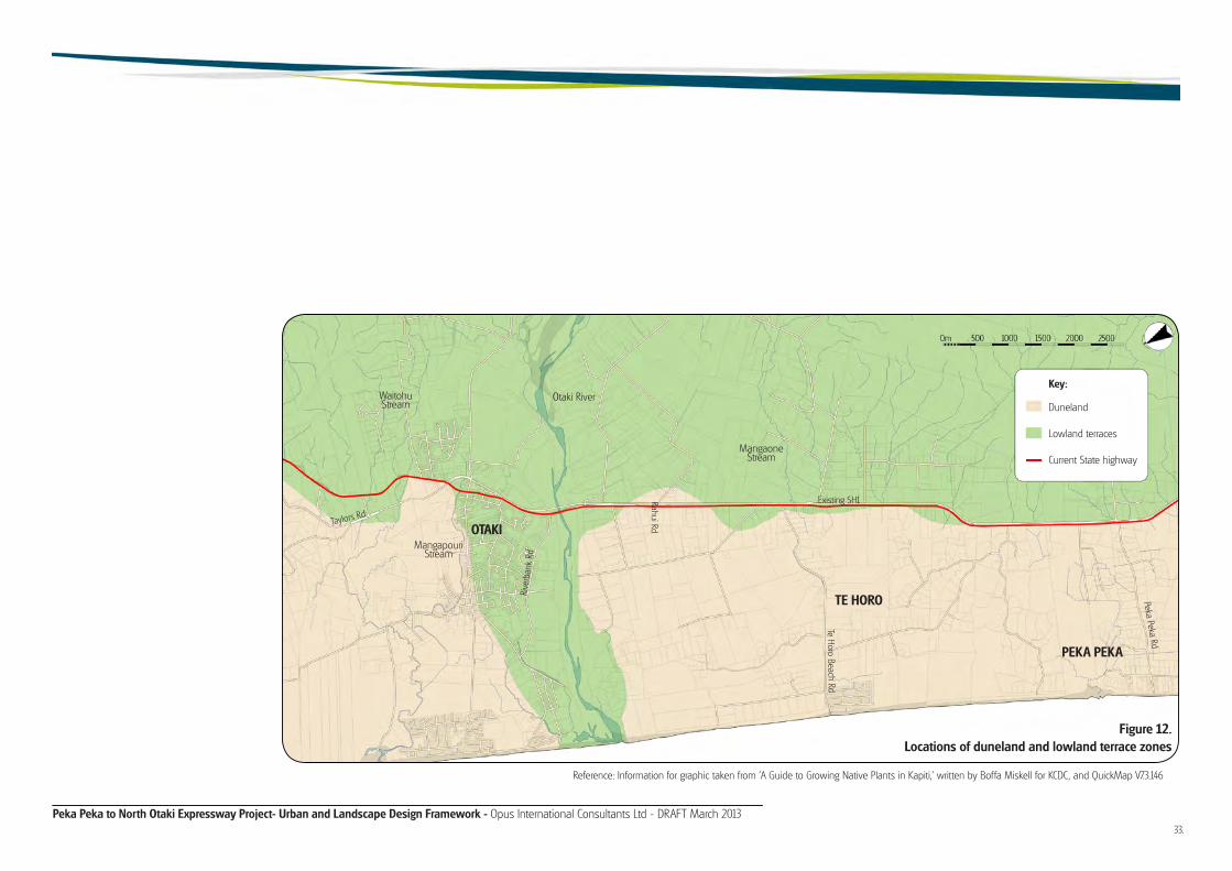
Peka Peka to North Otaki Expressway Project- Urban and Landscape Design Framework - Opus International Consultants Ltd - DRAFT March 2013
Reference: Information for graphic taken from 'A Guide to Growing Native Plants in Kapiti,' written by Boffa Miskell for KCDC, and QuickMap V7.3.146
Figure 12.Locations of duneland and lowland terrace zones
PEKA PEKA
TE HORO
OTAKI
Otaki RiverWaitohu Stream
Mangaone Stream
Peka Peka Rd
Te Horo Beach Rd
Existing SH1
Rive
rban
k Rd
Rahui Rd
Key:
Duneland
Lowland terraces
Current State highway
Mangapouri Stream
Taylors Rd
33.

Peka Peka to North Otaki Expressway Project- Urban and Landscape Design Framework - Opus International Consultants Ltd - DRAFT March 2013
Aquatic ecology
Many of the smaller watercourses have no riparian vegetation. Where riparian vegetation is present, it is typically dominated by willow.
GWRC Regional Freshwater Plan (RFP) identifies the Mangaone Stream, Otaki River and Waitohu Stream as watercourses with nationally threatened indigenous fish in the catchment, including Brown Mudfish, Shortjawed Kokopu, Banded Kokopu, Giant Kokopu, and Koaro. Parts of the Otaki River are also identified as important trout habitat. Fish passage must be considered during design.
These native fish species and the healthy habitats they require must be considered wherever the Project crosses waterways.
The Mangaone and Waitohu Streams have flourishing native bush cover along the upper reaches in the Tararua Forest, providing clean stream flows with healthy habitat for native fish. The streams are likely to have a diverse native fish fauna and invertebrates. The lower reaches and tributaries flow through farms and Otaki and Te Horo Townships. This increases
levels of phosphorus, nitrate, ammonia, sediment and faecal bacteria causing weeds and algae to grow.
Native plants have been established adjacent to the Mangapouri Stream through the Pare-o-Matangi Reserve, but due to habitat degradation, there are few ivertebrate and fish species present.
The Otaki River provides healthy habitat for native fish and invertebrates. However a lot of the small streams which run into the Otaki River do not. GWRC has put emphasis on improving these streams.
Native vegetation is being planted by GWRC and Friends of the Otaki River as streams banks are enhanced., following the Otaki River Environmental Strategy.
Typical existing riparian planting for streamsides in the area include willows, pine, native grasses, and exotic shrubs.
Design implications Unless properly designed, construction of the Project will slowly accumulate transport derived contaminants such as copper, zinc and hydrocarbons which are well known to have adverse effects on aquatic systems.
Principles to avoid or mitigate aquatic ecology effects1. Minimise stream and river crossings.
2. Cater for fish passage in culvert design.
3. Allow for native plants along riparian margins to provide a diverse range of shelter for aquatic insects, which in turn provide food for fish and birds.
4. Avoid discharging sediments within flowing waters.
5. Where practicable, encourage Expressway surface run-off to flow off the Expressway via an appropriate treatment train. Planting native vegetation along Expressway margins will help mitigate effects.
Refer to Section 4.2 to see the ULDF response to the existing vegetation and ecology in relation to the Project.

Peka Peka to North Otaki Expressway Project- Urban and Landscape Design Framework - Opus International Consultants Ltd - DRAFT March 2013
3.5 Land uses
Current
• The majority of the Project Area (Peka Peka to North Otaki) is currently zoned as rural.
• There are two zoned retail/commercial areas within Otaki Township: the Railway Retail Area, and Main Street Town Centre. The Main Street Town Centre serves the local Otaki community, while the Railway Retail Area serves both local and regional visitors.
• Many of Te Horo's community facilities (including Te Horo School) are located on the east side of the existing SH1, while the main residential area is on the west side. Therefore, connectivity across the existing SH1 is important for the functionality of the settlement.
Figure 13. Current Otaki land use
7
Beach Access
Beach Access
To Otaki Forks
Otaki River
12
3
45
67
89
10
11
Mangapouri Stream
Waitohu Stream
Key:Existing SH1NIMT railwayResidentialRetailHorticulturePublic green spaceEcological heritage siteHeritage tree / buildingIndustrialRecreationEducationLocal connection routesStream / river
Main Street Town CentreRaukawa MaraePipi TrailOtaki DomainHaruatai ParkOtaki CollegeOtaki Railway Retail AreaOtaki RacecourseBrown Sugar CafeWinstones AggregatesCleanTech business parkOtaki Lake developmentRecreational access / developmentPare-o-Matangi Reserve
12345678910111213
14
14
35.

Peka Peka to North Otaki Expressway Project- Urban and Landscape Design Framework - Opus International Consultants Ltd - DRAFT March 2013
Future
• Within the Project Area, KCDC has expressed desire for future industrial and residential growth to be based around Otaki.
• Development of the existing industrial zone along Riverbank Road is currently underway as a 'CleanTech' business park. This is intended to be of local and Regional significance.
• Although severance is more acute at Te Horo, the settlement is small and is likely to remain so as the KCDC Plan seeks to restrict residential development here to retain the rural character.
• There is a proposed Otaki Lake Development, which includes the development of a lake and amenities to the north of Winstones Aggregates on the northern bank of the Otaki River. The Project alignment runs along the western side of the Otaki Lake area so consideration will need to be given to how local access to the area would be achieved.
Figure 14. Otaki Vision land use, plus Project
Beach Access
Beach Access
To Otaki Forks
Otaki River
Potential Road Access or Walkway
to River
Waitohu Stream
7
12
3
45
67
89
10
11
1213
Mangapouri Stream
Key:Existing SH1NIMT railwayResidentialRetailHorticulturePublic green spaceEcological heritage siteHeritage tree / buildingIndustrialRecreationEducationLocal connection routesStream / riverExpresswayMain Street Town CentreRaukawa MaraePipi TrailOtaki DomainHaruatai ParkOtaki CollegeOtaki Railway Retail AreaOtaki RacecourseBrown Sugar CafeWinstones AggregatesCleanTech business parkOtaki Lake developmentRecreational access / developmentPare-o-Matangi Reserve
12345678910111213
14
14

Peka Peka to North Otaki Expressway Project- Urban and Landscape Design Framework - Opus International Consultants Ltd - DRAFT March 2013
There are six different landuse types bordering the Expressway corridor. These landuses, along with relatively subtle changes in landform, inform urban and landscape character areas.
Refer to FIgure 15A.
Rural
The majority of the Expressway corridor passes through rural land as outlined in Figure 15A, with the resultant rural character being dominant from Peka Peka to Otaki River (the Hautere Plains), and then from Waitohu Stream to Taylors Road.
The former marine terrace escarpment immediately east of the SH1/Peka Peka Road intersection contained the southern end of the Project Area. To the west and northward extends the rolling contour of the local duneland topography. This area of pastoral farming is broken by an irregular pattern of conifer shelterbelts.
North of Te Horo and to the east of the existing SH1 and NIMT railway, the land flattens out to a localised area of broad plain that drains towards the Otaki River. This plain contains further pastoral farming
and areas of horticultural production. The latter landuse has a regimented pattern of shelterbelts. There are also several small remnant stands of totara and kanuka in the area.
A small area of rural landuse is visible east of the existing SH1 and NIMT railway within the Otaki River floodplain and then the rural aspect becomes obvious again from the river terrace to the north of Rahui Road. This terrace and another short ridge between the railway and the Waitohu Stream are the only landform features of note, other than the river and stream channels, in the northern extent of the study area. To the north is the distinctly undulating farmland of the Horowhenua Plains.
Lifestyle
Directly related to the rural landuse and located within the rural character area are a number of smallholdings. These are more intensively subdivided, contain various dwellings and outbuildings and a variety of amenity and production tree and shrub plantings. Their intensity and diversity of development is what differentiates these ‘lifestyle blocks' from their immediate rural surroundings.
Residential
Within the Expressway corridor the main areas of residential character are confined to the Otaki Township area with a section of residential ribbon development on the west side of the existing SH1 just north of Otaki River and on both sides of the existing SH1 immediately north of the northern river terrace and the local railway overbridge.
Many of the dwellings whose sections front onto the existing SH1 have relatively dense plantings of amenity trees and shrubs on their highway frontages. These have been planted as a buffer between the dwelling and the constant flow of highway traffic.
Reserve / open space
While quite rural in aspect, the few reserve areas within the Project Area are focussed on Otaki, being the immediate southern bank of the Otaki River and Pare-o-Matangi Reserve, and an ‘island’ of land between Rahui Road and the Otaki Railway Station.
Industrial
Currently industrial landuse within the Project corridor is confined to the immediate area of the northern bank of the Otaki River. Gravel extraction from the bed of the river for aggregate and concrete making is the main business. The industrial activity is not highly visible from the existing SH1 as the bridge structure obscures the view.
Commercial / retail
Predominantly retail landuse forms the focus of the Otaki Railway Retail Area (described in Section 5.4). The visual diversity and retail outlet business activity within this area is one of the most memorable aspects when travelling through this section of the existing SH1.
While the amenity in this area is currently degraded by traffic congestion (which will be reduced as a result of the Project), it is a focus and vibrant part of the local community.
Transportation
A subsidiary landuse, but common to the whole of the Project Area is roading paralleled by railway. While this is not actually a character area, it bisects or forms the edge of a variety of character areas. It is the conduit from which the travelling public observes the local landscape and in turn impacts upon those landscapes.
Summary
The Project corridor traverses two distinct overall landscape types - rural and urban - and in so doing it is important to acknowledge the specific landscape character areas and their particular opportunities and constraints during the design process. A particularly important consideration will be to ensure that the built or 'urban' form of the Project does not overwhelm the areas of rural landscape.
In rural areas it is important to consider integration or re-establishment of (but not limited to) the existing contours, existing vegetation patterns (such as shelterbelts), and planted noise bunds rather than noise walls (should specific 'built' noise mitigation be required).
3.6 Character areas
37.

Peka Peka to North Otaki Expressway Project- Urban and Landscape Design Framework - Opus International Consultants Ltd - DRAFT March 2013
Key: Photo points for Fig. 10 Rural Lifestyle Residential Reserve / open space Industrial Commercial/Retail
1
2 34 5
6 87 9 10 11
12 13
1. Taylors RoadRural Character, with eastern foothills in the background. Foothill views lessen on approach to urban Otaki.
2. Northern Regional gatewayLifestyle property to the east, rural and commercial to the west.
3. West Otaki residentialResidential to the east and to the west, with scattered business activity.
4. Rahui Road roundaboutSH1 traffic is often congested at this roundabout. Pare-o-Matangi Reserve is to the east.
5. Otaki Railway Retail AreaMain strip of outlet shops both sides of highway. Amenities for through traffic e.g. coffee stalls and petrol stations.
6. Transition areaRoad parallel to railway on the east. Residences on the west, with occasional commercial e.g. Brown Sugar Cafe.
7. Industrial areaIndustrial character at the approach to the Otaki River. Eastern foothills visible again, indicating end of urban area.
8. Otaki River/gateway exitThe Otaki River and the Rest area to the east indicate the gateway of Otaki.
9. Rural / light commercialPredominantly rural area, with some commercial and horticultural activity to the west. Clusters of localised vegetation.
Figure 15B.Current State highway travel experience
10. North Te HoroModest gateway into Te Horo. Rural / lifestyle to the east, and a mix of lifestyle and businesses to the west.
11. Te Horo Beach RoadUnderstated roads and rural/lifestyle properties both east and west sides of the highway. Clustered vegetation. Shelterbelt planting framing numerous rural properties.
12. Duneland / ruralPredominantly rural character with undulating duneland. Clusters of localised vegeta-tion, and scattered exotics. Shelterbelt planting framing numerous rural properties.
13. Peka Peka RoadRural properties border both sides of the SH1, with the Tararua foothills still visible. At the southern extent of the project the Te Hapua escarpment rises to the east of the SH1.
Figure 15A.Urban and landscape character areas
#
OTAKI
TE HORO

Peka Peka to North Otaki Expressway Project- Urban and Landscape Design Framework - Opus International Consultants Ltd - DRAFT March 2013
3.7 Tangata whenua and heritage The Kapiti Coast has a rich history - both Maori and European. It is important to understand the diverse cultural heritage of Otaki, so that areas of significance are acknowledged and protected. It is also important to understand the cultural values and history of the area, so that the treatment of the corridor can be appropriately designed to represent and celebrate the area and the community. Input by the Project team's archaeologists and heritage specialists in hand with iwi liaison is an integral part of the design process for the Project.
The tangata whenua of the District are Te Ãti Awa ki Whakarongotai, Ngati Raukawa ki te Tonga, Ngati Toa Rangatira, and their whanau and hapu. Ngati Raukawa ki te Tonga are the predominant iwi of the Project Area.
The Nga Hapu-o-Otaki Cultural Impact Assessment (CIA) has been prepared for the Project to identify the specific cultural values that may be affected, and to ensure appropriate measures to avoid, remedy or mitigate any adverse effects are identified. Refer to the CIA or the specialist Archaeological and Built Heritage reports for the AEE for more information.
The CIA has notes that the sand dunes at North Otaki are of cultural significance, as well as Te Horo Pa, and the area has been identified as potentially containing
archaeological evidence.
Below are some of the events which have shaped the Project Area into the places we experience today.
Pre 1822- Muaupoko iwi lived on the Kapiti Coast, utilising the areas marine, coastal, wetland and forest resources.
1822 to 1824- Te Rauparaha joined Ngati Toa iwi from Kawhia to Kapiti.
1825 to 1828- Te Rauparaha and his allies (Ngati Raukawa and Te Ãti Awa) migrated to Horowhenua and south of the Otaki River.
1833 to 1847- Shore whalers from Australia set up stations along the coast.
1834- The wars of Haowhenua in the Te Horo area.
1839- British missionary Octavius Hadfield worked in Otaki from 1839, and taught the Maori to cultivate wheat.
1840- Maori Chiefs of the 3 Kapiti tribes signed the Treaty of Waitangi.
1840s- British settlers arrived in the Region. Christianity, literacy and farming spread rapidly among Maori of the Region.
1851- Rangiatea Church built in 1851 by
hundreds of Maori under the leadership of Te Rauparaha.
1853- Otaki Native Boys College was established. Hundreds of boarders came to the school from around the country. Some of the buildings now service Te Wananga o Raukawa.
1859- St Mary’s Catholic Church was built . This is considered to be New Zealand's oldest surviving Catholic church still in use.
1850s to 1880s- Sheep farms (Maori and Pakeha) were established in the area. The beach was used as a highway for trading produce with Wellington. A church school for Maori children and Otaki State School also opened during this time.
1886- Railway was established between Wellington and Longburn. Otaki Maori Racing Club established - This is the only Maori racing club in New Zealand.
1892- Te Horo School was built .
1906- A through road was completed, bridging the Waikanae and Otaki Rivers.
1890 to 1930- Dairying and horticulture flourished at Te Horo and Otaki.
1930- All Saints Anglican Church was built .
1975- An education programme was established for the Region’s iwi (Ngati Raukawa, Ngati Toa, and Te Ãti Awa). Kohanga reo and schools were established.
1980s- Commerce and industry grew at Otaki
1981- Te Wananga o Raukawa, the Maori University of Otaki was established.
1989- Kapiti Coast District Council was established. A District Plan was drawn up to guide rural and urban growth.
1990s- Population growth was among the highest in New Zealand.
1991- Rangiatea Church (New Zealand's oldest surviving Maori Church) was destroyed by fire. Local iwi, hapu, the Anglican Church and KCDC worked together to rebuild the church in 2003. The roof alone is lined with 60,000 toetoe stems, and the tukutuku panels are made from 130,000 kiekie plant fibre strips.
1998- New library opened at Otaki.
39.

Peka Peka to North Otaki Expressway Project- Urban and Landscape Design Framework - Opus International Consultants Ltd - DRAFT March 2013
25.
21.
31.
26.
27.28.
30.29.
12.9.
13.
19.
20.
23.
0m 500 1000 1500 2000 2500
Existing SH1
Te H
oro
Beac
h RdRive
rban
k Rd
Rahu
i Rd
Peka Peka Rd
Scho
ol R
d
8.
OTAKITE HORO
PEKA PEKA
Note: Sites marked with * are potentially affected by the Project.
7.2.
3. 4.
1.
6.
5.
10.11.
14.
15.
16.
18.17.
22.
1. Urupa and Pa Tararua 2. Dunes*3. Hema Te Ao I - Kainga*4. Spring*5. Mamao 6. Old mill7. Pareamatangi 8. Victorian Bay Villa*9. Former Rahui Milk Treatment Factory and Social Hall*10. Rahui Creek11. Kainga Gardens (Ngati Maewaka)12. Otaki Railway Station*13. Otaki Racecourse
14. Waiariki Stream (aka Turanga Rahui or Rahui Creek)15. Kaingaraki Kainga16. Kaingaraki Pa17. Horseshoe Tearooms (Brown Sugar Cafe)18. Te Wao Pukatea19. Te Waha o te Marangai20. Pahiko21. Mirek Simesk Pottery Site*22. Clifden at Bridge Lodge*23. Te Horo Pa*24. Haowhenua Pa25. Te Horo School
26. Otaki Primary School27. Civic Precinct East(includes War Memorial Hall, Public Library, Atmore Memorial, Raukawa Marae)28. Civic Precinct West(includes WWI Memorial, Plunket Rooms, Civic Theatre, Memorial Restroom, Christianity Memorial and Te Rauparaha Monument.29. Rangiatea and Cemetery30. Te Wananga-o-Raukawa (Maori University) and Native School (Kohanga Reo)31. Railway houses
Figure 16.Location of heritage sites, sites of historic value, and known sites of Maori significance near the Project corridor
Reference: Base Map information taken from QuickMap V7.3.146
Key:
24.

Peka Peka to North Otaki Expressway Project- Urban and Landscape Design Framework - Opus International Consultants Ltd - DRAFT March 2013
3.8 Community facilities
41.
Town Centres
• The Project traverses residential and rural areas. The main residential area is around Otaki. In addition, there is the smaller settlement of Te Horo south of Otaki.
• The residential areas of Otaki Township fall on both sides of the Project corridor (east and west Otaki). Overall, the community is most densely settled around Otaki Main Street Town Centre on the western side of the corridor. There is also a residential area extending westward to Otaki Beach.
Emergency services
• It is important that police, fire services and ambulance services have efficient, legible connections to and from the Expressway and around their local community.
Churches
• The majority of churches are located along Mill Road and Main Street, which indicates that they will be affected by the Project unless the strong east-west connection along Mill Road and Rahui Road is maintained as a main local route or a viable alternative is provided.
• The Highway Baptist Church is also likely to be affected, as it is located on the existing SH1 on the Te Manuao Road corner.
Sports facilities
Otaki Racecourse (located along Rahui Road) is home to the Otaki Maori Racing Club and the Levin Racing Club. It is a well used facility, used daily by up to 140 horses in training, 'largely because of its ideal location in the central lower North Island and excellent training facilities.' 5
Reserves
• Pare-o-Matangi Reserve does not hold reserve status under the Reserves Act, but is a green space of importance to the community. The CIA notes the reserve is also of importance to iwi as there was historically a Hauhau community living there and because a Ngati Maiotaki chief named the land.
• Pare-o-Matangi Reserve will change significantly as a result of the Project. This provides opportunity: Firstly, if the reserve is extended, it can be developed to provide a buffer between the Expressway and Otaki. Also, the open space allows any underpass on Rahui Road to be treated as a landscape element with longer ramps to ensure a high-quality pedestrian environment.
• While the park might become known as a local and even Regional landmark, quiet contemplative “naturalistic” landscapes may be more difficult to achieve.
Education
• Education facilities are well represented in the Otaki area, with 8 primary/secondary schools that fall within close proximity to the Project route: Te Horo Primary, Otaki College, Otaki School, Waitohu Primary, Otaki Health Camp School, St Peter Chanel School, Te Kura-a-Iwi o Whakatupuranga Rua Mano, and Te Kura Kaupapa Maori o Te Rito.
• The wider effects associated with accessibility, connectivity and safety may affect (or benefit) the schools within the Project Area and need to be considered.
• The east-west connection along Rahui Road and 'the ramp' (the existing SH1 bridge which provides access between east and west Otaki) is important for students to travel between school and residential areas.
• The schools located closest to the alignment and most likely to be affected are Otaki College, Waitohu Primary, Te Horo Primary, and Otaki School.
• In total there are approximately 1300 students attending schools within the general Project Area.
• The geographic area that the schools draw their students from is likely to be relatively large due to the distances between communities. This means that students may utilise various methods to get to school including walking, cycling, public transport and private cars.
• The accessibility and safety of these various networks needs to be considered, given that the Project could create severance effects for the current connections between residences and schools.
5. http://www.nzracing.co.nz/goracing/racecourse.aspx/29

Peka Peka to North Otaki Expressway Project- Urban and Landscape Design Framework - Opus International Consultants Ltd - DRAFT March 2013
Figure 17.Location of community facilities
15
33
3425
4
18
24232
1714
16
310
2931
2730
1911 6
82012 22
2197
1335
1
26
3228
5
36
0m 500 1000 1500 2000 2500
Existing SH1
Te H
oro
Beac
h Rd
Rive
rban
k Rd
Rahu
i Rd
Scho
ol R
d
Reference: Base Map information taken from QuickMap V7.3.146
OTAKI TE HORO
PEKA PEKA
Otaki Beach
Te Horo Beach
Key:1. Te Horo Primary2. Otaki College3. Otaki School4. Waitohu Primary5. Otaki Health Camp School6. St Peter Chanel School7. Te Kura-a-iwi o Whakatupu-ranga Rua Mano8. Te Kura Kaupapa Maori o te Rito9. Te Wananga o Raukawa10. Otaki Cemetery11. Convent Road Cemetery12. Te Rauparaha Street Cemetery13. Otaki Library and Service Centre14. Otaki Pool15. Otaki Racecourse16. Otaki Domain17. Haruatai Park
18. Pare-o-Matangi Reserve19. Catholic Church20. Raniatea Church21. Otaki Apostolic Church22. Anglican Church23. Presbyterian Church24. Jehovahs Witness Otaki25. Highway Baptist Church26. St Margaret’s Te Horo27. Otaki Memorial Hall28. Te Horo Hall29. Otaki Medical Centre30. Otaki Police Station31. Otaki Fire Station32. Te Horo Volunteer Fire Station33. Otaki Ambulance Station34. Otaki Railway Station35. Otaki Museum36. Hyde Park Museum

Peka Peka to North Otaki Expressway Project- Urban and Landscape Design Framework - Opus International Consultants Ltd - DRAFT March 2013
3.9 Movement networks
• Currently the existing SH1 and NIMT railway corridor creates severance effects for pedestrians, cyclists and horse riders - particularly in Otaki and Te Horo. This severance corridor could increase with the creation of the Project. However, with careful consideration of the needs and movements of these users, decreased severance and improved community outcomes will result.
• In Otaki, there is a strong diagonal desire line between Mill Road and Te Manuao Road (the Waitohu Plateau). Therefore this movement network between the two residential areas should be maintained.
• Mill Road and Rahui Road form the other key east - west connection, particularly to the Otaki Racecourse. Therefore some form of link (preferably allowing for vehicles, but cyclist and pedestrians as a minimum) between Mill Road and Rahui Road should be maintained where practicable.
• Passenger transport must be able to easily access all parts of the community, including the residential
area to the east of the existing SH1, the railway station, Otaki Beach and locations to the south.
• In Te Horo, most community facilities are located to the east of the existing SH1, while the residential development is primarily on the western side. An appropriate link for all modes of transport should be provided between the two areas to minimise the severance created by the Project and the NIMT railway corridor.
• The main bridleway routes run along the recreational paths parallel to the Otaki River and southeast towards the river from Waitohu Valley Road.
• Design and alteration to movement networks should consider the current and future vision outlined in the KCDC Cycleways, Walkways and Bridleways Strategy (refer to Section 2.2).
• Throughout the rest of the Project Area, distances are generally too great for walking to be a viable mode of transport. However, cycling is still feasible, especially for
experienced cyclists. The provision of a safe route for cyclists along the length of the Project Area in addition to connections across the Project needs to be considered in the design of the Project.
• Allowance for future double tracking of the NIMT railway corridor along the length of the Project is a key criteria.
• It is also important to maintain accessibility to the railway station at Otaki.
43.

Peka Peka to North Otaki Expressway Project- Urban and Landscape Design Framework - Opus International Consultants Ltd - DRAFT March 2013
Figure 18.Pedestrian, cycle, bridleway and public transport networks
Key
Pedestrian CycleBridlewayPublic transportExisting SH1
0m 500 1000 1500 2000 2500
Existing SH1
Te H
oro
Beac
h Rd
Rive
rban
k Rd
Rahu
i Rd
Peka Peka Rd
Scho
ol R
d
Reference: Kapiti Coast District Council, Received 2004
TE HOROOTAKI
PEKA PEKA
Mill
Rd
Waitohu Valley Rd
Te Manuao Rd