sewer and water infrastructure expansion plan - saco, maine draft_ sewer and water... · the water...
TRANSCRIPT
Sewer and Water InfrastructureExpansion Plan
Prepared for:
City of Saco, Maine and
Maine Water Company
February 2016
Final Draft Report
ES-1
Executive Summary
Sewer and Water Infrastructure Expansion
Purpose Development pressure in West Saco has prompted the City to evaluate the water and sewer
infrastructure improvements needed to support growth west of the Maine Turnpike. The City of
Saco in conjunction with the Maine Water Company retained CDM Smith to assist with this
planning study. The resulting Technical Memorandum establishes a basis for future sewer and
water infrastructure expansion while considering overall coordination among the two utilities.
The plan will serve as a road map for sensible expansion of sewer and water utilities on the west
side of the Maine Turnpike to support that development when it occurs.
Background The east side of Saco includes the majority of the existing sewer and water infrastructure. See
Figures 1 and 2 in the Technical Memorandum. The existing sewer system includes 71 miles of
mainline sewer and force mains, 31 pumping stations and a wastewater treatment plant. The
water system in Saco is served by Maine Water Company, which is a regulated water utility that
owns 12 public water systems in Maine, including the system for Saco and three adjacent
municipalities (Scarborough, Old Orchard Beach, Biddeford).
Future Development Areas There were four future land development and system expansion opportunities identified on the
west side of the Maine Turnpike. Coordination meetings were held with the City of Saco to
determine the limits of sewer expansion, coinciding with future development areas, topography
and current private development planning projects. The majority of the expansion areas are
zoned for R-1D (low density single residential), with one area falling in the R-4 category (General
resident district). The future development areas, shown on Figure 3, were named by a centrally-
located street, and include the following:
• New County Road Area
• Buxton Road Area
• Jenkins Road Area
• Flag Pond Road Area
The future development areas had a 30% factor deducted to account for roadways, open space,
parks, and other planning items. Each area was divided by three lot size development rates to
Executive Summary • Sewer and Water Infrastructure Expansion
ES-2
determine projected house counts. The house counts were then used to estimate future sewer
flows and water demands. Those lot size development rates were:
• 7,500 Square feet per house
• 15,000 Square feet per house
• 30,000 Square feet per house
Sewer Expansion Plan The planning for the sewer system expansion began with the analysis of several factors, which
included topography, location of existing sewers, failing septic systems, future development
areas, brook crossings, and feasibility of water system expansion. The topography and brook
crossings created natural boundaries where gravity sewers could be installed. Further extension
beyond the natural boundaries or low spots would require additional pump stations, which add
more cost and maintenance to the City. The closer existing sewers were located to a development
area, the more feasible sewer expansion could be to serve these areas. The table below
summarizes the linear footage (LF) of gravity sewer, force main, pump stations (PS) and Maine
Turnpike (Tpk) crossing proposed for each development area.
Water Expansion Plan The existing water distribution system in Saco is fed from a booster station and 24-inch water
main from Biddeford. The water distribution expansion plan follows along the same areas as the
sewer expansion plan. A water model was used to determine the needs for the future
development areas. Due to higher elevation on the west side of the highway, a high service zone
and new booster station will be required. Further, a new water storage tank near Flag Pond
Road/Jenkins Road intersection will be required to sustain the service pressures determined by
the Fire Chief. A summary of the water infrastructure needs follow.
Gravity (LF) Force Main (LF) PS (#) Tpk Crossing
Jenkins Road (Fig. 6-9) 9,420 1,900 1 0
New County Road (Fig. 4) 3,300 2,450 1 0
Buxton Road (Fig. 5) 5,830 0 0 0
Flag Pond Road (Fig. 10) 20,240 1,500 1 1
Totals 38,790 5,850 3 1
Note: Jenkins Road preferred Alternative B included.
Sewer Expansion SummaryArea
Main (LF) PS (#) Tank (#)
Jenkins Road 8,600 0 0
New County Road 4,650 0 0
Buxton Road 0 1 0
Flag Pond Road 12,300 0 1
Totals 25,550 1 1
Water Expansion SummaryArea
Executive Summary • Sewer and Water Infrastructure Expansion
ES-3
Planning Level Costs The utility expansion program includes providing a planning level cost estimate for both sewer
and water infrastructure. The planning level costs are divided by expansion area and include
present day (Year 2016) costs for all planning level estimates. Also, a 25% construction
contingency and a 25% engineering and implementation allowance are factored into the totals.
The preparation of final design plans will provide more information on site-specific conditions
and can impact these figures. Factors to consider will include increased rock removal, wetland
issues, endangered species, brook crossings, etc. The table below provides a summary of the
planning level costs.
Implementation Plan The implementation of the utility expansion should be done in a phased manner. The future
development projects will help dictate where and when each phase of the expansion should
begin. Below is a brief summary of the future development areas and associated phasing for both
sewer and water.
New County Road
The sewer and water expansion in this area can proceed independently from the other three
areas. The sewer expansion will include gravity sewer and a pump station, which will connect to
an existing gravity sewer on the east side of the highway. Further, the lot sizes should be limited
to a minimum of 15,000 square feet (SF). Smaller lot sizes (7,500 SF) would increase house
counts and sewer flows, which would be larger than what the highway crossing sewer and
downstream system can handle.
The water expansion will draw from the existing main on New County Road, west of the highway.
The water service will remain on the current hydraulic grade line provided by the existing
booster station in Biddeford.
Buxton Road
The sewer expansion in this area can proceed when a future development area is ready. The
developer will have to coordinate with the City to determine if the projected flow to the Buxton
pump station warrants an upgrade.
The existing water network extends through the Buxton Road area. However, design conditions
(maximum day demand plus fire flow) are reaching their limits with the existing system. Any
Jenkins Road $5,070,000 $1,700,000
New County Road $1,140,000 $900,000
Buxton Road $2,560,000 $1,700,000
Flag Pond Road $9,280,000 $6,800,000
Totals $18,050,000 $11,100,000
Note: Cost reflect February 2016 dollars.
Area Sewer Planning Level
Cost Estimate
Water Planning Level
Cost Estimate
Executive Summary • Sewer and Water Infrastructure Expansion
ES-4
future development in this area may require the construction of the new booster station on Pine
Street near the Buxton Road intersection.
Jenkins Road
A portion of the sewer expansion in this area is currently under design in coordination with a
private developer. The remaining sewer expansion can proceed as the development projects
arise, including a new pump station near the midpoint on Jenkins Road.
Similarly to the sewer expansion, a portion of the water expansion is currently under design with
the same private developer. It is not expected that the new booster station will be needed for this
project. However, any future development projects will need to plan for installation of the booster
station along with a new water main on Jenkins Road.
Flag Pond Road
The sewer expansion in this area will require extensive construction of new sewer main, a pump
station and trenchless highway crossing. However, the sewer expansion can be done
independently of the other three areas.
The water expansion in this area will require construction of water mains to both Jenkins Road
and Flag Pond Road, east of the highway. This work cannot be completed until the Jenkins Road
water expansion is constructed first. The other important infrastructure improvement to this
area is the elevated water storage tank near the Flag Pond Road/Jenkins Road intersection. The
tank will need to be constructed prior to development areas becoming active to create available
water storage and minimize booster station operation.
Utility Expansion Planning Summary memorandum.docx
Technical Memorandum
To: City of Saco, Maine and Maine Water Company
From: Neal Campbell, P.E. (NH) and Erin Smith, P.E. (NH)
Date: February 11, 2016
Subject: Sewer and Water Infrastructure Expansion Plan
The purpose of this technical memorandum is to establish the basis for a future and
comprehensive facilities plan update, serve as a decision making tool in evaluating future
developer requests for sewer and water expansion, and discuss other considerations toward the
Sewer and Water Infrastructure Expansion Plan. The technical memorandum was prepared as
part of Task Order No. 2 with the City of Saco and Task Order No. 1 with Maine Water Company.
Background and Existing Information
This technical memorandum was prepared with help and coordination from representatives
from the Planning Department, Public Works, City Engineer, Water Resource Recovery Division,
Maine Water Operations and Engineering, and the Fire Chief.
The City of Saco, Maine owns and maintains a wastewater collection system comprised of 71
miles of mainline sewer/force main, 31 pumping stations and a wastewater treatment plant
(WWTP). The collection system services approximately 15,500 people and has 4,750 residential
users and 240 commercial/industrial users. The majority of the wastewater infrastructure and
customers are located east of the Maine Turnpike (Route 95). See Figure 1.
The Maine Water Company is a regulated public water utility that owns 12 public water systems
in the state of Maine, and which serves more than 32,000 customers (approximately 80,000
residents). One of those public water systems serves the City of Saco and three adjacent
municipalities (Scarborough, Old Orchard Beach, and Biddeford). See Figure 2.
To understand the existing sewers and water systems, both the City of Saco and Maine Water
Company provided their latest GIS data. The data was combined with State of Maine GIS
features, to create mapping for each utility. Maine Water Company also provided their existing
water model data to assist with the future development analysis.
Future Development Areas
The existing sewer and water systems are both well developed on the east side of the Maine
Turnpike. Future land development opportunities and system expansion were investigated on
the west side of the Maine Turnpike plus two others off the northern portion of Route 1. The
future development areas were named by a centrally-located street.

Insert – Figure 1

Insert – Figure 2

City of Saco, Maine Water Company
February 11, 2016
Page 2
Sewer and Water Infrastructure Expansion Plan memorandum
The four future development areas are shown on Figure 3 and include the following:
• New County Road Area (see the areas labeled “NC”)
• Buxton Road Area (see the areas labeled “BX”)
• Jenkins Road Area (see the areas labeled “JK”)
• Flag Pond Road Area (see the areas labeled “FP”)
Coordination meetings were held with the City of Saco to determine the limits of sewer
expansion, coinciding with future development areas, topography and current private
development planning projects. Discussion over the current town zoning maps and zone
designations helped develop this task. Further explanation is provided below.
Failing Septic Systems/Contaminated Wells
The existence of failing septic systems and contaminated wells within existing sewer or water
systems can be a key factor when investigating the expansion of a utility. Clustering of these
negative environmental conditions will create adverse conditions and could warrant utility
expansion. The City of Saco noted a few problematic areas at the mobile home parks on the
northerly end of Route 1 and Boothby Park. Maine Water did not report any contaminated wells,
so no further analysis was performed on this issue.
Sewer Expansion Plan
The planning for the sewer system expansion began with the analysis of several factors, which
included topography, location of existing sewers, failing septic systems, future development
areas, brook crossings, and feasibility of water system expansion. The topography and brook
crossings created natural boundaries where gravity sewers could be installed. Further
extension beyond the natural boundaries or low spots would require additional pump stations,
which add more cost and maintenance to the City. The closer existing sewers were located to a
development area the more feasible sewer expansion could be to serve these areas.
The next step in planning the sewer system expansion was to determine the future flows from
each area. The majority of the expansion areas are zoned for R-1D (low density single
residential), with one area (Boothby) falling in the R-4 category (General residential district).
Upon discussions with the City (representatives from Planning Board, Public Works and Water
Resource Recovery Division), three lot sizes were chosen to divide into the future development
areas. The lot sizes were as follows:
• 7,500 Square feet (SF) per house
• 15,000 Square feet per house
• 30,000 Square feet per house
Before calculating the number of houses for each future development area, a 30% factor was
deducted from the area to account for roadways, open space, parks, and other planning items.

Insert – Figure 3
City of Saco, Maine Water Company
February 11, 2016
Page 3
Sewer and Water Infrastructure Expansion Plan memorandum
Table 1 displays the house count summary for all the sewer expansion areas and future
development areas within them.
New County Road Area
The New County Road Area (see Figure 4) extends from an existing sewer located at the
intersection of Shadagee Road and New County Road (Route 5), east of the Maine Turnpike
(Route 95) westerly to a high point near Big Ledge Brook. New County Road extends over the
highway, where sewer expansion would need to pass underneath the highway. On the west side
of the highway, the topography gradually increases from a low point at Deep Brook crossing,
where a pump station will be located to send flow back to the existing sewer.
A private developer is preparing plans to develop approximately 90 new houses (Precious
Hidden Valley Estates) to a property located directly west of the highway and south of New
County Road. As part of their wastewater management plan, the developer intends to install a
pump station to send flow underneath the highway to the same existing sewer mentioned
above. In coordination with the City, they are required to install a second force main parallel to
their force main, to serve as a future highway crossing for the New County Road sewer flow.
There are approximately 19 existing homes located along the roadway and two large future
development areas. The future development areas (NC1 and NC2) are on either side of New
County Road and can be seen in Figure 4. The downstream capacity (495,000 gpd @ slope =
0.004, n = 0.013) of the existing 8-inch sewer is smaller than the peak flow (641,300 gpd)
assuming the 7,500 SF lot size. As a result the City has to limit the lot sizes in the development
areas to 15,000 SF or higher. Further, the City is requiring the current developer of Precious
Hidden Valley Estates to install the second force, parallel to the development’s 4-inch force
main, to 6-inch diameter the meet flow constraints. A summary of the sewer flows can be seen
in Table 2.
A downstream sewer capacity analysis was performed to determine if the additional flow from
New County Road would create an adverse downstream condition. Ten sewer segments ranging
in diameter from 10-inch to 12-inch were investigated on Bradley Street. Recent invert
elevations gathered from field inspections were used to calculate the pipe capacities. The
segment with the smallest capacity was 1,070,300 gpd (SMH 1037.108 to 1037.109). Comparing
the projected peak New County flows plus the theoretical peak flow from the existing
residents/businesses along Bradley Street, the downstream pipe capacity can easily
accommodate the flow (474,600 gpd).
Buxton Road Area
The Buxton Road Area sewer extends from an existing sewer on Buxton Road near the Blake
Avenue intersection westerly to a high point just south of Louden Road. The topography
gradually increases from the existing sewer to the high point. From that high point the
topography quickly drops off at the Sandy Brook crossing.
There are approximately 138 homes located along Buxton Road and a few side streets. The five
future development areas are on either side of Buxton Road and can be seen in Figure 5. The
City reports that the Buxton Road pump station has been designed to accommodate larger

Table 1
Existng and Future House Count Summary
100% 70% 7,500 15,000 30,000
Jenkins Road
Existing 58 58 58
JK1 3,263,165 2,284,216 305 152 76
JK2 3,716,945 2,601,862 347 173 87
JK3 12,910,771 9,037,540 1,205 603 301
W. Side Village 100 100 100
Jenkins Subtotal 19,890,881 13,923,617 2,014 1,086 622
New County Road
Existing 19 19 19
NC1* 2,250,654 1,575,458 105 105 53
NC2* 10,918,794 7,643,156 510 510 255
Precious HV Ests. 90 90 90
New County Subtotal 13,169,448 9,218,614 724 724 416
Buxton Road
Existing 138 138 138
BX1 2,666,769 1,866,738 249 124 62
BX2 4,698,342 3,288,839 439 219 110
BX3 4,204,650 2,943,255 392 196 98
BX4 3,162,504 2,213,753 295 148 74
BX5 1,252,674 876,872 117 58 29
Buxton Subtotal 15,984,939 11,189,457 1,630 884 511
Flag Pond Road
Existing 135 135 135
Hearns Rd 93 93 93
FP1 1,403,846 982,692 131 66 33
FP2 2,501,852 1,751,296 234 117 58
FP3 9,461,837 6,623,286 883 442 221
FP4 2,503,116 1,752,181 234 117 58
FP5 1,310,122 917,085 122 61 31
17,180,773 12,026,541 1,832 1,030 629
FP6*^ 5,355,234 3,748,664 250 250 125
FP7*^ 14,232,122 9,962,485 664 664 332
Flag Pond Subtotal 36,768,129 25,737,690 2,746 1,944 1,086
Grand Total (w/o FP6 & 7) 66,226,041 46,358,229 6,200 3,724 2,178
Grand Total (w/ FP6 & 7) 85,813,397 60,069,378 7,114 4,638 2,635
* = Proposed Areas shall only consider 15,000 SF lot size or larger. Small 7,500 SF lot size not feasible.
= House counts impacted by above scenario
^ = Flag Pond Road Areas FP6 and FP7 are not included in new High Service Zone.
High Service Zone Subtotal
House Count at Lot Size with 70% Size
of Area
Future Development Area
Size (SF)Area
2/2/2016

Insert – Figure 4
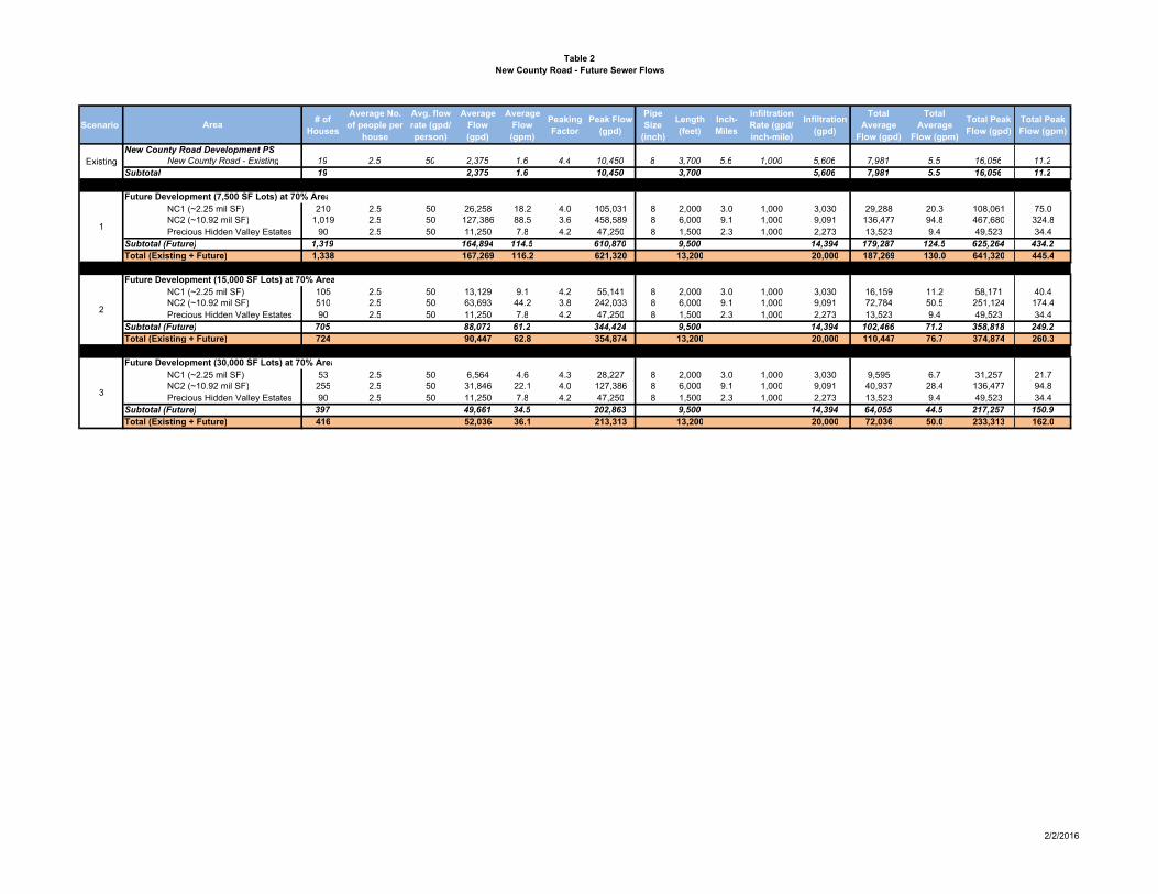
Table 2
New County Road - Future Sewer Flows
Scenario# of
Houses
Average No.
of people per
house
Avg. flow
rate (gpd/
person)
Average
Flow
(gpd)
Average
Flow
(gpm)
Peaking
Factor
Peak Flow
(gpd)
Pipe
Size
(inch)
Length
(feet)
Inch-
Miles
Infiltration
Rate (gpd/
inch-mile)
Infiltration
(gpd)
Total
Average
Flow (gpd)
Total
Average
Flow (gpm)
Total Peak
Flow (gpd)
Total Peak
Flow (gpm)
New County Road Development PS
New County Road - Existing 19 2.5 50 2,375 1.6 4.4 10,450 8 3,700 5.6 1,000 5,606 7,981 5.5 16,056 11.2
Subtotal 19 2,375 1.6 10,450 3,700 5,606 7,981 5.5 16,056 11.2
Future Development (7,500 SF Lots) at 70% Area
NC1 (~2.25 mil SF) 210 2.5 50 26,258 18.2 4.0 105,031 8 2,000 3.0 1,000 3,030 29,288 20.3 108,061 75.0
NC2 (~10.92 mil SF) 1,019 2.5 50 127,386 88.5 3.6 458,589 8 6,000 9.1 1,000 9,091 136,477 94.8 467,680 324.8
Precious Hidden Valley Estates 90 2.5 50 11,250 7.8 4.2 47,250 8 1,500 2.3 1,000 2,273 13,523 9.4 49,523 34.4
Subtotal (Future) 1,319 164,894 114.5 610,870 9,500 14,394 179,287 124.5 625,264 434.2
Total (Existing + Future) 1,338 167,269 116.2 621,320 13,200 20,000 187,269 130.0 641,320 445.4
Future Development (15,000 SF Lots) at 70% Area
NC1 (~2.25 mil SF) 105 2.5 50 13,129 9.1 4.2 55,141 8 2,000 3.0 1,000 3,030 16,159 11.2 58,171 40.4
NC2 (~10.92 mil SF) 510 2.5 50 63,693 44.2 3.8 242,033 8 6,000 9.1 1,000 9,091 72,784 50.5 251,124 174.4
Precious Hidden Valley Estates 90 2.5 50 11,250 7.8 4.2 47,250 8 1,500 2.3 1,000 2,273 13,523 9.4 49,523 34.4
Subtotal (Future) 705 88,072 61.2 344,424 9,500 14,394 102,466 71.2 358,818 249.2
Total (Existing + Future) 724 90,447 62.8 354,874 13,200 20,000 110,447 76.7 374,874 260.3
Future Development (30,000 SF Lots) at 70% Area
NC1 (~2.25 mil SF) 53 2.5 50 6,564 4.6 4.3 28,227 8 2,000 3.0 1,000 3,030 9,595 6.7 31,257 21.7
NC2 (~10.92 mil SF) 255 2.5 50 31,846 22.1 4.0 127,386 8 6,000 9.1 1,000 9,091 40,937 28.4 136,477 94.8
Precious Hidden Valley Estates 90 2.5 50 11,250 7.8 4.2 47,250 8 1,500 2.3 1,000 2,273 13,523 9.4 49,523 34.4
Subtotal (Future) 397 49,661 34.5 202,863 9,500 14,394 64,055 44.5 217,257 150.9
Total (Existing + Future) 416 52,036 36.1 213,313 13,200 20,000 72,036 50.0 233,313 162.0
2
3
Area
Existing
1
2/2/2016

Insert – Figure 5
City of Saco, Maine Water Company
February 11, 2016
Page 4
Sewer and Water Infrastructure Expansion Plan memorandum
pumps and should be able to handle the additional flows from the future areas. A summary of
the sewer flows can be seen in Table 3.
A sewer capacity analysis was performed to determine if the additional flow from the Buxton
Road Area would create an adverse downstream condition. Nineteen sewer segments ranging in
diameter from 8-inch to 24-inch were investigated on North Street and cross country off North
Street/Nye Street. The sewer flows from this area flow southerly on North Street through a 12-
inch sewer then southwest along Spring Street through an 18-inch then 24-inch sewer. During
peak conditions, the flow can exit through an higher elevated invert into a relief 10-inch sewer
cross country pipe near Nye Street connecting to the 24-inch sewer on Spring Street. Recent
invert elevations gathered from field inspections and existing elevations were used to calculate
the pipe capacities. There was one pipe segment with unknown elevation through the cross
country route that was not included. The segments with the smallest capacity were 1,399,100
gpd (SMH 1242.131 to 1242.130) along North Street and 406,800 gpd (SMH 1247.105 to
1247.109) along the cross country sewer. Comparing the projected peak Buxton Road flows
plus the theoretical peak flow from the existing residents/businesses upstream, the combined
downstream pipe capacity can accommodate the flow (1,478,400 gpd) assuming the 7,500 SF
lot size. Further, the downstream capacity of the sewer just along North Street can
accommodate the flow (1,128,400 gpd) assuming the 15,000 SF lot size.
A discussion of the downstream sewer capacity analysis for both Buxton Road Area and Jenkins
Road Area is included under the Jenkins Road Area below.
Jenkins Road Area
The Jenkins Road Area is located along Jenkins Road which runs parallel to the highway. The
sewer limits along Jenkins extend from the existing sewer near the Steeple Drive intersection
northerly to the Cascade Brook crossing.
There are approximately 58 homes located along Jenkins Road. The three future development
areas are on either side of Jenkins Road. There is also a private developer that intends to install
100 houses (West Side Village) on a parcel adjacent to the highway.
This sewer expansion layout was not as straightforward as the other three areas. As a result,
seven alternatives were investigated on how to serve this area. The following is brief
description of the alternatives and the feasibility of each.
Alternative A
This alternative considered a gravity sewer pipe from the last existing house on Jenkins Road
south of Cascade Brook to the entrance of the new West Side Village private development near
Sofia Road. The sewer flows would then be incorporated into the private development’s new
pump station design. Due to the topography of Jenkins Road, there is an approximate stretch of
2,000 linear feet of sewer that needs to be 25-30 feet deep. Typical construction equipment and
means/methods are not feasible at this construction depth, so this alternative was not
recommended. See Figure 6 for a map of this alternative.

Table 3
Buxton Road - Future Sewer Flows
Scenario# of
Houses
Average No.
of people per
house
Avg. flow
rate (gpd/
person)
Average
Flow
(gpd)
Average
Flow
(gpm)
Peaking
Factor
Peak Flow
(gpd)
Pipe
Size
(inch)
Length
(feet)
Inch-
Miles
Infiltration
Rate (gpd/
inch-mile)
Infiltration
(gpd)
Total
Average
Flow (gpd)
Total
Average
Flow (gpm)
Total Peak
Flow (gpd)
Total Peak
Flow (gpm)
Buxton Road Development PS
Existing houses 138 2.5 50 17,250 12.0 4.1 70,725 8 6,000 9.09 1,000 9,091 26,341 18.3 79,816 55.4
Subtotal 138 17,250 12.0 70,725 6,000 9,091 26,341 18.3 79,816 55.4
Future Development (7,500 SF Lots) at 70% Area
BX1 (~2.67 mil SF) 249 2.5 50 31,112 21.6 4.0 124,449 8 700 1.06 1,000 1,100 32,212 22.4 125,549 87.2
BX2 (~4.70 mil SF) 439 2.5 50 54,814 38.1 3.8 208,293 8 400 0.61 1,000 1,100 55,914 38.8 209,393 145.4
BX3 (~4.20 mil SF) 392 2.5 50 49,054 34.1 3.9 191,312 8 2,800 4.24 1,000 1,100 50,154 34.8 192,412 133.6
BX4 (~3.16 mil SF) 295 2.5 50 36,896 25.6 3.9 143,894 8 2,000 3.03 1,000 1,100 37,996 26.4 144,994 100.7
BX5 (~1.25 mil SF) 117 2.5 50 14,615 10.1 4.1 59,920 8 2,500 3.79 1,000 1,100 15,715 10.9 61,020 42.4
Subtotal (Future) 1,492 186,491 129.5 727,867 8,400 5,500 191,991 133.3 733,367 509.3
Total (Existing + Future) 1,630 203,741 141.5 798,592 14,400 14,591 218,332 151.6 813,183 564.7
Future Development (15,000 SF Lots) at 70% Area
BX1 (~2.67 mil SF) 124 2.5 50 15,556 10.8 4.1 63,780 8 700 1.06 1,000 1,100 16,656 11.6 64,880 45.1
BX2 (~4.70 mil SF) 219 2.5 50 27,407 19.0 4.0 109,628 8 400 0.61 1,000 1,100 28,507 19.8 110,728 76.9
BX3 (~4.20 mil SF) 196 2.5 50 24,527 17.0 4.0 98,109 8 2,800 4.24 1,000 1,100 25,627 17.8 99,209 68.9
BX4 (~3.16 mil SF) 148 2.5 50 18,448 12.8 4.1 75,637 8 2,000 3.03 1,000 1,100 19,548 13.6 76,737 53.3
BX5 (~1.25 mil SF) 58 2.5 50 7,307 5.1 4.2 30,691 8 2,500 3.79 1,000 1,100 8,407 5.8 31,791 22.1
Subtotal (Future) 746 93,245 64.8 377,844 8,400 5,500 98,745 68.6 383,344 266.2
Total (Existing + Future) 884 110,495 76.7 448,569 14,400 14,591 125,086 86.9 463,160 321.6
Future Development (30,000 SF Lots) at 70% Area
BX1 (~2.67 mil SF) 62 2.5 50 7,778 5.4 4.2 32,668 8 700 1.06 1,000 1,100 8,878 6.2 33,768 23.4
BX2 (~4.70 mil SF) 110 2.5 50 13,703 9.5 4.1 56,184 8 400 0.61 1,000 1,100 14,803 10.3 57,284 39.8
BX3 (~4.20 mil SF) 98 2.5 50 12,264 8.5 4.2 51,507 8 2,800 4.24 1,000 1,100 13,364 9.3 52,607 36.5
BX4 (~3.16 mil SF) 74 2.5 50 9,224 6.4 4.2 38,741 8 2,000 3.03 1,000 1,100 10,324 7.2 39,841 27.7
BX5 (~1.25 mil SF) 29 2.5 50 3,654 2.5 4.3 15,711 8 2,500 3.79 1,000 1,100 4,754 3.3 16,811 11.7
Subtotal (Future) 373 46,623 32.4 194,811 8,400 5,500 52,123 36.2 200,311 139.1
Total (Existing + Future) 511 63,873 44.4 265,536 14,400 14,591 78,464 54.5 280,126 194.5
1
2
3
Area
Existing
2/2/2016

Insert – Figure 6
City of Saco, Maine Water Company
February 11, 2016
Page 5
Sewer and Water Infrastructure Expansion Plan memorandum
Alternative B
This alternative sends all flow by gravity to a low spot near the midpoint of Jenkins Road. A
proposed pump station would send flow from the low spot southwesterly on Jenkins Road to a
new gravity sewer at the high point near Sofia Road. In order to extend gravity sewer from the
high point to the existing sewer near Steeple Drive, the road elevation must be raised by
approximately 6-feet at the low spot at the Goosefare Brook crossing. A retaining wall would be
a feasible solution to help support this road construction. This grade adjustment would allow
the gravity sewer to connect into the existing system and avoid the need for a second pump
station. This is the preferred alternative and a summary of the sewer flows can be seen in Table
4. Also, see Figure 7 for a map of this alternative.
Alternative C
This alternative is reliant upon the downstream portion of the Flag Pond Road Area sewer
expansion being constructed. Similarly to Alternative B, gravity sewer goes to a low spot near
the midpoint of Jenkins Road. However, the proposed pump station for this alternative instead
sends flow northeasterly towards a second proposed pump station just north of the Cascade
Brook crossing along Jenkins Road. This second pump station sends flow northeasterly to the
proposed new gravity sewer along Flag Pond Road. This alternative requires two pump stations
and extensive downstream infrastructure construction in order to be feasible. The additional
cost of the second pump station and sequence/schedule make this alternative not
recommended. See Figure 8 for a map of this alternative.
Alternative D
This alternative is also reliant upon the downstream portion of the Flag Pond Road Area sewer
expansion being constructed. The location of the proposed pump station on Jenkins Road is the
same as Alternative B and C, with the force main sending flow northeasterly to the Flag Pond
Road Area. No gravity flow on Jenkins Road north of Cascade Brook is included. This alternative
does not accommodate development along Jenkins Road north of Cascade Brook and south of
Flag Pond Road. Also, the need for extensive downstream infrastructure construction makes
this alternative not recommended. See Figure 8 for a map of this alternative.
Alternative E
This alternative is also reliant upon the downstream portion of the Flag Pond Road Area sewer
expansion being constructed. The location of the proposed pump station on Jenkins Road is
adjacent to the Cascade Brook crossing. Gravity flow north of the brook enters the pump station.
The force main sends flow northeasterly to the proposed new gravity sewer along Flag Pond
Road. This alternative requires approximately 2,700 linear feet of sewer to be installed 20-30
feet deep. Further the need for extensive downstream infrastructure construction makes this
alternative not recommended. See Figure 9 for a map of this alternative.
Alternative F
This alternative is similar to Alternative A, where all flow along Jenkins uses gravity sewer. The
flows in this alternative are directed towards the low spot located at the midpoint of the street.
From there, flow travels cross country southeasterly through a partially open area,
southwesterly parallel to the highway, then ends at the private developer’s pump station. Due to
the topography of the cross country area adjacent to the highway, the sewer depth would need
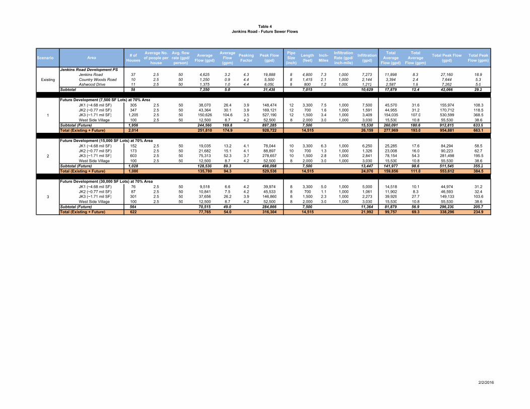
Table 4
Jenkins Road - Future Sewer Flows
Scenario# of
Houses
Average No.
of people per
house
Avg. flow
rate (gpd/
person)
Average
Flow (gpd)
Average
Flow
(gpm)
Peaking
Factor
Peak Flow
(gpd)
Pipe
Size
(inch)
Length
(feet)
Inch-
Miles
Infiltration
Rate (gpd/
inch-mile)
Infiltration
(gpd)
Total
Average
Flow (gpd)
Total
Average
Flow (gpm)
Total Peak Flow
(gpd)
Total Peak
Flow (gpm)
Jenkins Road Development PS
Jenkins Road 37 2.5 50 4,625 3.2 4.3 19,888 8 4,800 7.3 1,000 7,273 11,898 8.3 27,160 18.9
Country Woods Road 10 2.5 50 1,250 0.9 4.4 5,500 8 1,415 2.1 1,000 2,144 3,394 2.4 7,644 5.3
Ashwood Drive 11 2.5 50 1,375 1.0 4.4 6,050 8 800 1.2 1,000 1,212 2,587 1.8 7,262 5.0
Subtotal 58 7,250 5.0 31,438 7,015 10,629 17,879 12.4 42,066 29.2
Future Development (7,500 SF Lots) at 70% Area
JK1 (~4.68 mil SF) 305 2.5 50 38,070 26.4 3.9 148,474 12 3,300 7.5 1,000 7,500 45,570 31.6 155,974 108.3
JK2 (~0.77 mil SF) 347 2.5 50 43,364 30.1 3.9 169,121 12 700 1.6 1,000 1,591 44,955 31.2 170,712 118.5
JK3 (~1.71 mil SF) 1,205 2.5 50 150,626 104.6 3.5 527,190 12 1,500 3.4 1,000 3,409 154,035 107.0 530,599 368.5
West Side Village 100 2.5 50 12,500 8.7 4.2 52,500 8 2,000 3.0 1,000 3,030 15,530 10.8 55,530 38.6
Subtotal (Future) 1,956 244,560 169.8 897,285 7,500 15,530 260,091 180.6 912,815 633.9
Total (Existing + Future) 2,014 251,810 174.9 928,722 14,515 26,159 277,969 193.0 954,881 663.1
Future Development (15,000 SF Lots) at 70% Area
JK1 (~4.68 mil SF) 152 2.5 50 19,035 13.2 4.1 78,044 10 3,300 6.3 1,000 6,250 25,285 17.6 84,294 58.5
JK2 (~0.77 mil SF) 173 2.5 50 21,682 15.1 4.1 88,897 10 700 1.3 1,000 1,326 23,008 16.0 90,223 62.7
JK3 (~1.71 mil SF) 603 2.5 50 75,313 52.3 3.7 278,657 10 1,500 2.8 1,000 2,841 78,154 54.3 281,498 195.5
West Side Village 100 2.5 50 12,500 8.7 4.2 52,500 8 2,000 3.0 1,000 3,030 15,530 10.8 55,530 38.6
Subtotal (Future) 1,028 128,530 89.3 498,098 7,500 13,447 141,977 98.6 511,545 355.2
Total (Existing + Future) 1,086 135,780 94.3 529,536 14,515 24,076 159,856 111.0 553,612 384.5
Future Development (30,000 SF Lots) at 70% Area
JK1 (~4.68 mil SF) 76 2.5 50 9,518 6.6 4.2 39,974 8 3,300 5.0 1,000 5,000 14,518 10.1 44,974 31.2
JK2 (~0.77 mil SF) 87 2.5 50 10,841 7.5 4.2 45,533 8 700 1.1 1,000 1,061 11,902 8.3 46,593 32.4
JK3 (~1.71 mil SF) 301 2.5 50 37,656 26.2 3.9 146,860 8 1,500 2.3 1,000 2,273 39,929 27.7 149,133 103.6
West Side Village 100 2.5 50 12,500 8.7 4.2 52,500 8 2,000 3.0 1,000 3,030 15,530 10.8 55,530 38.6
Subtotal (Future) 564 70,515 49.0 284,866 7,500 11,364 81,879 56.9 296,230 205.7
Total (Existing + Future) 622 77,765 54.0 316,304 14,515 21,992 99,757 69.3 338,296 234.9
2
3
Area
Existing
1
2/2/2016

Insert – Figure 7

Insert – Figure 8

Insert – Figure 9

City of Saco, Maine Water Company
February 11, 2016
Page 6
Sewer and Water Infrastructure Expansion Plan memorandum
to be approximately 20-35 feet over 1,500 linear feet. Typical construction equipment and
means/methods, especially adjacent to the highway, are not feasible. This alternative was not
recommended. See Figure 6 for a map of this alternative.
Alternative G
This alternative is similar to Alternative B, where all flow is sent by gravity to a low spot near
the midpoint of Jenkins Road. A proposed pump station would send flow from the low spot
southerly on Jenkins Road to the high point near Sofia Road. The flow would run southeasterly
to the private developer’s sewer and enter their pump station. Flow would be pumped
underneath the highway to the existing sewer on Industrial Park Road. This alternative includes
a challenging and expensive crossing under the highway and is not recommended. See Figure 7
for a map of this alternative.
A sewer capacity analysis was performed to determine if the additional flow from the Jenkins
Road Area and Jenkins plus Buxton Road Area would create an adverse downstream condition.
The same nineteen sewer segments in the Buxton Road discussion above were included in this
analysis. Comparing the projected peak Jenkins Road flows plus the theoretical peak flow from
the existing residents/businesses upstream, the combined downstream pipe capacity
(1,805,924 gpd) can accommodate the flow (1,531,968 gpd) assuming the 7,500 SF lot size.
Further, the downstream capacity of the sewer just along North Street (1,399,135 gpd) can
accommodate the flow (1,172,027 gpd) assuming the 15,000 SF lot size.
The full build out scenario for Buxton Road Area and Jenkins Road Area will send sewer flows
through the same North Street sewers. Assuming the 7,500 SF lot size, the combined peak flow
from both areas plus the existing upstream peak flows (2,345,151 gpd) would exceed the sewer
capacity (1,805,924 gpd). Assuming the 15,000 SF lot size, the downstream sewer capacity can
accommodate the peak flow (1,635,187 gpd). Also, the existing 500 gpm pumps at the Buxton
Road pump station will need to be upgraded to approximately 1,200 gpm to handle the future
flow of both Buxton Road Area and Jenkins Road Area. Force main velocities within the 8-inch
and 10-inch section are not expected to exceed 5 and 8 feet per second respectively during this
peak flow condition. Based on these flows/capacity, it is not recommended to allow for full build
out to 7,500 SF lots throughout both future development areas unless upgrades are made to the
sewer capacity along the North Street.
Flag Pond Road Area
The Flag Pond Road Area sewer extends from an existing sewer on Route 1 near the Cascade
Road intersection northerly on Route 1, westerly on Flag Pond Road, crosses underneath the
highway, to a pump station at the low point near Harmon Brook, westerly to Lincoln Road and
the Boothbay Area.
There are approximately 135 existing homes along Flag Pond and Lincoln Road (a.k.a. Boothby
Park), with another 93 homes on Hearns Road, which is a perpendicular street to Flag Pond
running northerly towards Scarborough. Flow from these existing homes is included in the
analysis. There are five future development areas on the west side of the highway and two
larger areas on the east side. See Figure 10 to view the future development areas. Due to the
location of the two larger areas on the east side and adjacent to Route 1 and the likelihood of

Insert – Figure 10
City of Saco, Maine Water Company
February 11, 2016
Page 7
Sewer and Water Infrastructure Expansion Plan memorandum
development in this area, the house count calculation did not use the 7,500 SF lot size house
count, but instead utilizes the 15,000 SF count. A summary of the sewer flows can be seen in
Table 5.
There was no downstream capacity analysis performed for the Flag Pond Area because all flow
was accounted during the design of the existing downstream sewers and Cascade Pump Station.
Water Distribution Expansion Plan
The water distribution expansion plan follows along the same areas as the sewer expansion
plan. This joined utility expansion effort allows for developers to understand how both sewer
and water can reach their prospective area. The plan also gives the City of Saco and Maine
Water Company a planning and financial tool for guiding developers on how they should
proceed with future development areas.
The existing water distribution system is fed from a 24-inch water main from Biddeford that
runs northerly along the western side of the Maine Turnpike to Route 5 (New County Road).
There is a booster station in Biddeford that creates a hydraulic grade line of approximately 210
feet and services Saco to the east of the Maine Turnpike and a few small areas to the west of the
Maine Turnpike. Further, a new water storage tank in Biddeford is under construction that will
provide a few extra feet of head (~214-feet) into the system. There are currently no booster
pumping stations or high-service zones in Saco.
The water distribution expansion plan will focus on the same four areas discussed in the sewer
expansion plan. The existing and future house counts used to calculate sewer flows will be used
for calculating the water demand for the water expansion. The range of future house counts
relative to lot size will be presented separately along with the expected water flows. In
coordination with Maine Water, the calculation of average day demand used 2.5 persons per
home and 50 gallons per day per person. A peaking factor of 2.3 was used to determine the
maximum day demand. Table 6 includes the water flows for each area under the different
demands based on house count.
Water model software (InfoWater developed by Innovyze) was used with the existing water
model provided by Maine Water Company’s engineer, Tata & Howard. The service goal is to
provide all homes with enough water to meet the maximum day demand plus fire flow at
satisfactory pressure. A meeting was held with the Fire Chief to ascertain the fire flow
requirement in the expansion areas. The Chief stated that all expansion to the west of the
highway will be residential/rural and 500 gallons per minute (gpm) was sufficient. Any
development along the Route 1 corridor on the east side of the highway will need to be 1,000
gpm because it is commercial/mixed use district (MU-3 zoned). Below is the area-specific
discussion of water expansion infrastructure and hydraulics, while Figure 11 includes a map of
the water expansion plan.
New County Road Area
The New County Road Area is in close proximity to the 24-inch water main. An existing 8-inch
water main extends westerly a short distance along New County Road from the 24-inch. It is
recommended that a 12-inch water main will connect to the existing 8-inch main and extend
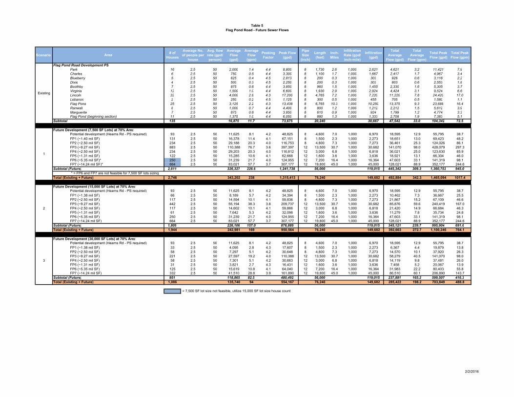
Table 5
Flag Pond Road - Future Sewer Flows
Scenario# of
Houses
Average No.
of people per
house
Avg. flow
rate (gpd/
person)
Average
Flow
(gpd)
Average
Flow
(gpm)
Peaking
Factor
Peak Flow
(gpd)
Pipe
Size
(inch)
Length
(feet)
Inch-
Miles
Infiltration
Rate (gpd/
inch-mile)
Infiltration
(gpd)
Total
Average
Flow (gpd)
Total
Average
Flow (gpm)
Total Peak
Flow (gpd)
Total Peak
Flow (gpm)
Flag Pond Road Development PS
Park 16 2.5 50 2,000 1.4 4.4 8,800 8 1,730 2.6 1,000 2,621 4,621 3.2 11,421 7.9
Charles 6 2.5 50 750 0.5 4.4 3,300 8 1,100 1.7 1,000 1,667 2,417 1.7 4,967 3.4
Blueberry 5 2.5 50 625 0.4 4.5 2,813 8 200 0.3 1,000 303 928 0.6 3,116 2.2
Dixie 4 2.5 50 500 0.3 4.5 2,250 8 200 0.3 1,000 303 803 0.6 2,553 1.8
Boothby 7 2.5 50 875 0.6 4.4 3,850 8 960 1.5 1,000 1,455 2,330 1.6 5,305 3.7
Virginia 12 2.5 50 1,500 1.0 4.4 6,600 8 1,930 2.9 1,000 2,924 4,424 3.1 9,524 6.6
Lincoln 32 2.5 50 4,000 2.8 4.3 17,200 8 4,765 7.2 1,000 7,220 11,220 7.8 24,420 17.0
Lebanon 2 2.5 50 250 0.2 4.5 1,125 8 300 0.5 1,000 455 705 0.5 1,580 1.1
Flag Pond 25 2.5 50 3,125 2.2 4.3 13,438 8 6,765 10.3 1,000 10,250 13,375 9.3 23,688 16.4
Ranwall 8 2.5 50 1,000 0.7 4.4 4,400 8 800 1.2 1,000 1,212 2,212 1.5 5,612 3.9
Marguerite 7 2.5 50 875 0.6 4.4 3,850 8 610 0.9 1,000 924 1,799 1.2 4,774 3.3
Flag Pond (beginning section) 11 2.5 50 1,375 1.0 4.4 6,050 8 880 1.3 1,000 1,333 2,708 1.9 7,383 5.1
Subtotal 135 16,875 11.7 73,675 20,240 30,667 47,542 33.0 104,342 72.5
Future Development (7,500 SF Lots) at 70% Area
Potential development (Hearns Rd - PS required) 93 2.5 50 11,625 8.1 4.2 48,825 8 4,600 7.0 1,000 6,970 18,595 12.9 55,795 38.7
FP1 (~1.40 mil SF) 131 2.5 50 16,378 11.4 4.1 67,151 8 1,500 2.3 1,000 2,273 18,651 13.0 69,423 48.2
FP2 (~2.50 mil SF) 234 2.5 50 29,188 20.3 4.0 116,753 8 4,800 7.3 1,000 7,273 36,461 25.3 124,026 86.1
FP3 (~9.27 mil SF) 883 2.5 50 110,388 76.7 3.6 397,397 12 13,500 30.7 1,000 30,682 141,070 98.0 428,079 297.3
FP4 (~2.50 mil SF) 234 2.5 50 29,203 20.3 4.0 116,812 12 3,000 6.8 1,000 6,818 36,021 25.0 123,630 85.9
FP5 (~1.31 mil SF) 122 2.5 50 15,285 10.6 4.1 62,668 12 1,600 3.6 1,000 3,636 18,921 13.1 66,304 46.0
FP6 (~5.35 mil SF)* 250 2.5 50 31,239 21.7 4.0 124,955 12 7,200 16.4 1,000 16,364 47,603 33.1 141,319 98.1
FP7 (~14.24 mil SF)* 664 2.5 50 83,021 57.7 3.7 307,177 12 19,800 45.0 1,000 45,000 128,021 88.9 352,177 244.6
Subtotal (Future) 2,611 326,327 226.6 1,241,738 56,000 119,015 445,342 309.3 1,360,753 945.0
* = FP6 and FP7 are not feasible for 7,500 SF lots sizing
Total (Existing + Future) 2,746 343,202 238 1,315,413 76,240 149,682 492,884 342.3 1,465,094 1017.4
Future Development (15,000 SF Lots) at 70% Area
Potential development (Hearns Rd - PS required) 93 2.5 50 11,625 8.1 4.2 48,825 8 4,600 7.0 1,000 6,970 18,595 12.9 55,795 38.7
FP1 (~1.38 mil SF) 66 2.5 50 8,189 5.7 4.2 34,394 8 1,500 2.3 1,000 2,273 10,462 7.3 36,667 25.5
FP2 (~2.50 mil SF) 117 2.5 50 14,594 10.1 4.1 59,836 8 4,800 7.3 1,000 7,273 21,867 15.2 67,109 46.6
FP3 (~9.27 mil SF) 442 2.5 50 55,194 38.3 3.8 209,737 12 13,500 30.7 1,000 30,682 85,876 59.6 240,419 167.0
FP4 (~2.50 mil SF) 117 2.5 50 14,602 10.1 4.1 59,866 12 3,000 6.8 1,000 6,818 21,420 14.9 66,684 46.3
FP5 (~1.31 mil SF) 61 2.5 50 7,642 5.3 4.2 32,098 12 1,600 3.6 1,000 3,636 11,279 7.8 35,734 24.8
FP6 (~5.35 mil SF) 250 2.5 50 31,239 21.7 4.0 124,955 12 7,200 16.4 1,000 16,364 47,603 33.1 141,319 98.1
FP7 (~14.24 mil SF) 664 2.5 50 83,021 57.7 3.7 307,177 12 19,800 45.0 1,000 45,000 128,021 88.9 352,177 244.6
Subtotal (Future) 1,809 226,106 157.0 876,889 56,000 119,015 345,121 239.7 995,904 691.6
Total (Existing + Future) 1,944 242,981 169 950,564 76,240 149,682 392,663 272.7 1,100,246 764.1
Future Development (30,000 SF Lots) at 70% Area
Potential development (Hearns Rd - PS required) 93 2.5 50 11,625 8.1 4.2 48,825 8 4,600 7.0 1,000 6,970 18,595 12.9 55,795 38.7
FP1 (~1.38 mil SF) 33 2.5 50 4,095 2.8 4.3 17,607 8 1,500 2.3 1,000 2,273 6,367 4.4 19,879 13.8
FP2 (~2.50 mil SF) 58 2.5 50 7,297 5.1 4.2 30,648 8 4,800 7.3 1,000 7,273 14,570 10.1 37,920 26.3
FP3 (~9.27 mil SF) 221 2.5 50 27,597 19.2 4.0 110,388 12 13,500 30.7 1,000 30,682 58,279 40.5 141,070 98.0
FP4 (~2.50 mil SF) 58 2.5 50 7,301 5.1 4.2 30,663 12 3,000 6.8 1,000 6,818 14,119 9.8 37,481 26.0
FP5 (~1.31 mil SF) 31 2.5 50 3,821 2.7 4.3 16,431 12 1,600 3.6 1,000 3,636 7,458 5.2 20,067 13.9
FP6 (~5.35 mil SF) 125 2.5 50 15,619 10.8 4.1 64,040 12 7,200 16.4 1,000 16,364 31,983 22.2 80,403 55.8
FP7 (~14.24 mil SF) 332 2.5 50 41,510 28.8 3.9 161,890 12 19,800 45.0 1,000 45,000 86,510 60.1 206,890 143.7
Subtotal (Future) 951 118,865 82.5 480,492 56,000 119,015 237,881 165.2 599,507 416.3
Total (Existing + Future) 1,086 135,740 94 554,167 76,240 149,682 285,422 198.2 703,849 488.8
= 7,500 SF lot size not feasible, utilize 15,000 SF lot size house count
2
3
Area
Existing
1
2/2/2016

Table 6
Water Demand Summary
7,500 SF Lots 15,000 SF Lots 30,000 SF Lots 7,500 SF Lots 15,000 SF Lots 30,000 SF Lots 7,500 SF Lots 15,000 SF Lots 30,000 SF Lots
Jenkins Road
JK1 305 152 76 38,070 19,035 9,518 87,562 43,781 21,890
JK2 347 173 87 43,364 21,682 10,841 99,738 49,869 24,935
JK3 1,205 603 301 150,626 75,313 37,656 346,439 173,220 86,610
W. Side Village 100 100 100 12,500 12,500 12,500 28,750 28,750 28,750
Jenkins Subtotal 1,956 1,028 564 244,560 128,530 70,515 562,489 295,619 162,185
New County Road
Existing 19 19 19 2,375 2,375 2,375 5,463 5,463 5,463
NC1* 105 105 53 13,129 13,129 6,564 30,196 30,196 15,098
NC2* 510 510 255 63,693 63,693 31,846 146,494 146,494 73,247
Precious HV Ests. 90 90 90 11,250 11,250 11,250 25,875 25,875 25,875
New County Subtotal 724 724 416 90,447 90,447 52,036 208,028 208,028 119,683
Buxton Road
Existing 138 138 138 17,250 17,250 17,250 39,675 39,675 39,675
BX1 249 124 62 31,112 15,556 7,778 71,558 35,779 17,890
BX2 439 219 110 54,814 27,407 13,703 126,072 63,036 31,518
BX3 392 196 98 49,054 24,527 12,264 112,825 56,412 28,206
BX4 295 148 74 36,896 18,448 9,224 84,861 42,430 21,215
BX5 117 58 29 14,615 7,307 3,654 33,613 16,807 8,403
Buxton Subtotal 1,630 884 511 203,741 110,495 63,873 468,604 254,140 146,907
Flag Pond Road
Existing 135 135 135 16,875 16,875 16,875 38,813 38,813 38,813
Hearns Rd 93 93 93 11,625 11,625 11,625 26,738 26,738 26,738
FP1 131 66 33 16,378 8,189 4,095 37,670 18,835 9,417
FP2 234 117 58 29,188 14,594 7,297 67,133 33,567 16,783
FP3 883 442 221 110,388 55,194 27,597 253,893 126,946 63,473
FP4 234 117 58 29,203 14,602 7,301 67,167 33,583 16,792
FP5 122 61 31 15,285 7,642 3,821 35,155 17,577 8,789
1,832 1,030 629 228,942 128,721 78,611 526,567 296,059 180,804
FP6*^ 250 250 125 31,239 31,239 15,619 71,849 71,849 35,925
FP7*^ 664 664 332 83,021 83,021 41,510 190,948 190,948 95,474
Flag Pond Subtotal 2,746 1,944 1,086 343,202 242,981 135,740 789,364 558,856 312,203
Grand Total (w/o FP6 & 7) 6,142 3,666 2,120 767,690 458,194 265,034 1,765,688 1,053,845 609,579
* = Proposed Areas shall only consider 15,000 SF lot size or larger. Small 7,500 SF lot size not feasible.
= House counts impacted by above scenario
^ = Flag Pond Road Areas FP6 and FP7 are not included in new High Service Zone.
Area
# of houses Average Day Demand (gal) Maximum Day Demand (gal)
High Service Zone Subtotal
2/3/2016

Insert – Figure 11
City of Saco, Maine Water Company
February 11, 2016
Page 8
Sewer and Water Infrastructure Expansion Plan memorandum
approximately 4,600 linear feet to a point before the Big Ledge Brook crossing. The same low
system hydraulic grade line (210-feet) as the existing system can service the high point
elevation and water flow/pressure requirement in this expansion area.
Buxton Road Area
The Buxton Road Area has an existing water main which extends from the east side of the
highway, under the highway and along Buxton Road where it ends just before the Sandy Brook
crossing. The limits of this existing water system exists with the City streets of this future
expansion areas, so no mainline water mains are required. However, the water model
determined that the existing water pressure at the westernmost point is close to the maximum
day plus fire flow limit. Any expansion along this Buxton Road corridor would increase water
demand and require more flow. As a result, a new booster station will be required to deliver the
additional demands at satisfactory pressure. In anticipation of this requirement, Maine Water
has already provided a 12-inch service and valving off the 24-inch main along Pine Street
presenting an ideal location for the booster station. Concurrent with the booster station
implementation, a new control valve will be required on the existing 24-inch main prior to
crossing under the highway, to isolate the high and low service zones. The existing pressure in
the low service area would not be able to accept the high service zone as pressure would exceed
the residential limits of 80 psi.
The new booster station was sized using the three lot size/house count scenarios. A 650 gpm,
400 gpm and 250 gpm pump was determined for the 7,500, 15,000 and 30,000 SF lots size
respectively. The booster station will operate at 90-feet of total dynamic head (TDH) in each
case.
Jenkins Road Area
The Jenkins Road Area has a short stretch of 12-inch water main extending northerly up Jenkins
Road from Buxton Road. The recommended 16-inch water main (or 12-inch if only 30,000 SF
lots are used) would connect to this 12-inch main and extend northerly approximately 8,000
linear feet to the Cascade Brook crossing. Similarly to Buxton Road, future expansion areas
would require the need for a booster station and inclusion within the high service system.
The West Side Village development project, mentioned in the sewer discussion above, is
currently under design to build approximately 100 homes off Jenkins Road adjacent to a parcel
along the highway. Maine Water is working with them to coordinate extension of the water
main to their development in conjunction with this memorandum. The existing water system
will be able to service this development without the need for the booster station.
Flag Pond Road Area
The Flag Pond Road Area includes an existing 8-inch water main which extends westerly from
Route 1 and ends just before the highway. The recommended 16-inch water main (12-inch if
only 30,000 SF lots are used) would connect to this 8-inch water main, cross underneath the
highway and continue westerly to Lincoln Road for approximately 8,300 linear feet. Further, the
water main will branch off southerly on Jenkins Road for approximately 4,500 linear feet and
connect to the future water main at the Cascade Brook crossing. The connection of these two
streets will tie the existing low pressure system on the east side of the highway to the new high
City of Saco, Maine Water Company
February 11, 2016
Page 9
Sewer and Water Infrastructure Expansion Plan memorandum
pressure system on the west side. A second control valve will be required on Flag Pond Road,
near the highway. This PRV, along with the Buxton Road PRV will create the pressure isolation
of these two systems.
Another major infrastructure improvement recommended during the Flag Pond Road Area
future development is an elevated water storage tank. Maine Water has acquired a piece of land
off Flag Pond Road east of the Jenkins Road intersection for the tank. The purpose will be to
provide a high service level for the entire expansion area, reduce the booster station run time
and plan for future water main extension to existing residents along Lincoln Road. This road
reaches a high point approximately 5,100 linear feet northwesterly from Flag Pond Road. The
active storage size will vary depending on the lot size/house count scenario. For planning
purposes, the active storage sizing is based herein on 25% of the maximum day demand plus
needed fire flow. The 7,500 SF lot size will result in a minimum tank size of 475,000 gallons, the
15,000 SF lot size will result in 300,000 gallons, and the 30,000 SF lot size will result in 190,000
gallons. In each case the approximate overflow height of the tank should be 125 feet above
ground surface elevation (approximately 291 feet elevation).
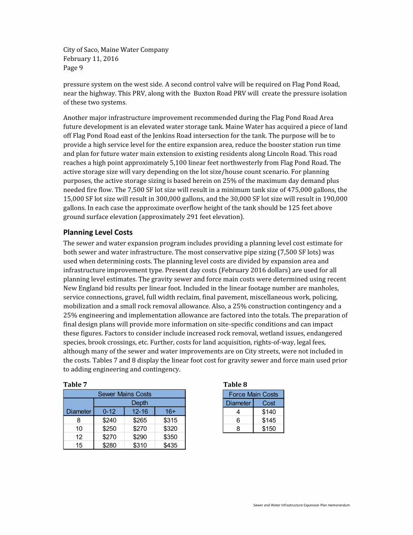
Planning Level Costs
The sewer and water expansion program includes providing a planning level cost estimate for
both sewer and water infrastructure. The most conservative pipe sizing (7,500 SF lots) was
used when determining costs. The planning level costs are divided by expansion area and
infrastructure improvement type. Present day costs (February 2016 dollars) are used for all
planning level estimates. The gravity sewer and force main costs were determined using recent
New England bid results per linear foot. Included in the linear footage number are manholes,
service connections, gravel, full width reclaim, final pavement, miscellaneous work, policing,
mobilization and a small rock removal allowance. Also, a 25% construction contingency and a
25% engineering and implementation allowance are factored into the totals. The preparation of
final design plans will provide more information on site-specific conditions and can impact
these figures. Factors to consider include increased rock removal, wetland issues, endangered
species, brook crossings, etc. Further, costs for land acquisition, rights-of-way, legal fees,
although many of the sewer and water improvements are on City streets, were not included in
the costs. Tables 7 and 8 display the linear foot cost for gravity sewer and force main used prior
to adding engineering and contingency.
Table 7 Table 8
Diameter 0-12 12-16 16+
8 $240 $265 $315
10 $250 $270 $320
12 $270 $290 $350
15 $280 $310 $435
Sewer Mains Costs
Depth Diameter Cost
4 $140
6 $145
8 $150
Force Main Costs

City of Saco, Maine Water Company
February 11, 2016
Page 10
Sewer and Water Infrastructure Expansion Plan memorandum
The cost for sewer pump stations can vary depending on many factors such as the size of the
station, pumps, standby generator, building (if necessary), etc. The pump stations included in
each expansion area are assumed to be submersible stations and shall carry the same cost for
each location. An average cost of submersible pump station bids in New England was
determined. The same construction contingency and engineering/implementation allowance
were included which totaled $500,000 per pump station.
The Flag Pond Road sewer and water expansion area will require a highway crossing
underneath the Maine Turnpike (Route 95). The means and methods of the sewer and water
main installation crossing have not been determined, but it is assumed that a trenchless
technology, such as horizontal directional drilling, will be used to avoid impacting traffic on the
highway. A typical cost for implementing this trenchless technology is $600 per foot. Assuming
the crossing is approximately 400-linear feet, plus construction contingency and
engineering/implementation allowance, the planning level estimate was $360,000.
The following Table 9 presents a summary of the sewer lengths by depth range and diameter for
each area, and Table 10 presents a summary of the sewer expansion costs for the areas
discussed within this memorandum.
Table 9
8 10 12
<12 3,000
12-16 300
<16
<12 1,000
12-16 1,000 830
>16 1,000 2,000
<12 1,190 3,490
12-16 570 900
>16 570 2,700
<12 7,620 3,995
12-16 5,275 300
>16 2,080 970
Total 23,605 2,830 12,355 38,790
3,300
Jenkins Rd
Flag Pond
5,830
Sewer Main Lengths (FT)
9,420
20,240
Sewer Diameter (inch)Depth (FT)Area Total
New County
Buxton Rd
City of Saco, Maine Water Company
February 11, 2016
Page 11
Sewer and Water Infrastructure Expansion Plan memorandum
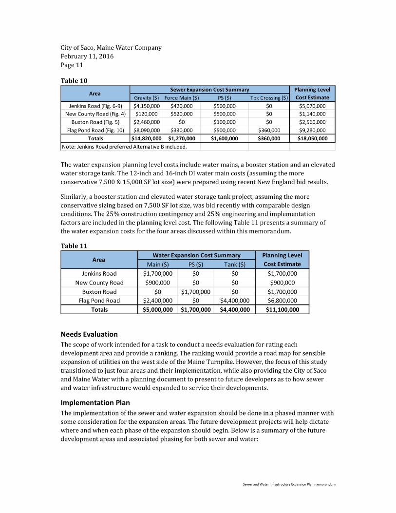
Table 10
The water expansion planning level costs include water mains, a booster station and an elevated
water storage tank. The 12-inch and 16-inch DI water main costs (assuming the more
conservative 7,500 & 15,000 SF lot size) were prepared using recent New England bid results.
Similarly, a booster station and elevated water storage tank project, assuming the more
conservative sizing based on 7,500 SF lot size, was bid recently with comparable design
conditions. The 25% construction contingency and 25% engineering and implementation
factors are included in the planning level cost. The following Table 11 presents a summary of
the water expansion costs for the four areas discussed within this memorandum.
Table 11
Needs Evaluation
The scope of work intended for a task to conduct a needs evaluation for rating each
development area and provide a ranking. The ranking would provide a road map for sensible
expansion of utilities on the west side of the Maine Turnpike. However, the focus of this study
transitioned to just four areas and their implementation, while also providing the City of Saco
and Maine Water with a planning document to present to future developers as to how sewer
and water infrastructure would expanded to service their developments.
Implementation Plan
The implementation of the sewer and water expansion should be done in a phased manner with
some consideration for the expansion areas. The future development projects will help dictate
where and when each phase of the expansion should begin. Below is a summary of the future
development areas and associated phasing for both sewer and water:
Gravity ($) Force Main ($) PS ($) Tpk Crossing ($)
Jenkins Road (Fig. 6-9) $4,150,000 $420,000 $500,000 $0 $5,070,000
New County Road (Fig. 4) $120,000 $520,000 $500,000 $0 $1,140,000
Buxton Road (Fig. 5) $2,460,000 $0 $100,000 $0 $2,560,000
Flag Pond Road (Fig. 10) $8,090,000 $330,000 $500,000 $360,000 $9,280,000
Totals $14,820,000 $1,270,000 $1,600,000 $360,000 $18,050,000
Note: Jenkins Road preferred Alternative B included.
Area Sewer Expansion Cost Summary Planning Level
Cost Estimate
Main ($) PS ($) Tank ($)
Jenkins Road $1,700,000 $0 $0 $1,700,000
New County Road $900,000 $0 $0 $900,000
Buxton Road $0 $1,700,000 $0 $1,700,000
Flag Pond Road $2,400,000 $0 $4,400,000 $6,800,000
Totals $5,000,000 $1,700,000 $4,400,000 $11,100,000
Area Water Expansion Cost Summary Planning Level
Cost Estimate

City of Saco, Maine Water Company
February 11, 2016
Page 12
Sewer and Water Infrastructure Expansion Plan memorandum
New County Road
The sewer and water expansion in this area can proceed independently from the other three
areas. The sewer expansion will include gravity sewer and a pump station, which shall connect
to a force main stub provided by a private developer to pass underneath the Maine Turnpike
and into an existing gravity sewer on the east side of the highway. The City is currently
coordinating the design of this stub with the private developer. Further, the lot sizes should be
limited to a minimum of 15,000 square feet. Smaller lot sizes (7,500 SF) will increase house
counts and sewer flows, which will be larger than what the highway crossing sewer and
downstream system can handle.
The water expansion will draw from the existing main on New County Road, west of the
highway. The water service will remain on the current hydraulic grade line provided by the
existing booster station in Biddeford.
Buxton Road
The sewer expansion in this area can proceed when a future development area is ready. The
developer will have to coordinate with the City to determine if the projected flow to the Buxton
pump station warrants an upgrade. As mentioned above, the Buxton Road pump station has
future built out space for larger pumps to satisfy future flows.
The existing water network extends through the Buxton Road Area. However, design conditions
(maximum day demand plus fire flow) are reaching their limits with the existing system. Any
future development in this area may require the construction of the new booster station on Pine
Street near the Buxton Road intersection.
Jenkins Road
A portion of the sewer expansion in this area is currently under design in coordination with a
private developer (West Side Village). The remaining sewer expansion can proceed as the
development projects arise, including a new pump station near the midpoint on Jenkins Road.
Similar to the sewer expansion, a portion of the water expansion is currently under design with
the same private developer. It is not expected that the new booster station will be needed for
this project. However, any future development projects will need to plan for installation of the
booster station along with a new water main on Jenkins Road.
Flag Pond Road
The sewer expansion in this area will require extensive construction of new sewer main, a
pump station and trenchless highway crossing. However, the sewer expansion can be done
independently of the other three areas.
The water expansion in this area will require construction of water mains to both Jenkins Road
and Flag Pond Road, east of the highway. This work cannot be completed until the Jenkins Road
water expansion is constructed first. Once in place, the Flag Pond expansion will create a loop in
the water system and provide a second point to separate the high and low service zones. The
other important infrastructure improvement to this area is the elevated water storage tank near
the Flag Pond Road/Jenkins Road intersection. The tank will need to be constructed prior to

City of Saco, Maine Water Company
February 11, 2016
Page 13
Sewer and Water Infrastructure Expansion Plan memorandum
development areas becoming active to create available water storage and minimize booster
station operation.
cc: Daniel P. Bisson, P.E. – CDM Smith
