settlement region - sdw.enr.gov.nt.casdw.enr.gov.nt.ca/nwtdp_upload/snow track monitoring...
TRANSCRIPT

Multi-species monitoring using winter track surveys in the Sahtú Settlement Region
Tulita November 10, 2015

Agenda • Introductions • Overview of program objectives and input received in
2014 • Data collected in March 2015 • Sampling equipment - what worked well and what didn’t • Review of methodology and proposed changes • logistics and budget – challenges and proposed changes
for this year’s program • Experience and insights from field crew members – what
worked well and what could be improved • Plans for this winter 2

CIMP funding Why did we apply?
• Concerns about cumulative effects • Monitoring programs lacking for many wildlife species • Need broad scale monitoring • Collaborative – Communities / Industry / Government • Standardization so data can be pooled
3
(Image: ConocoPhillips) (Image: Husky Ltd.)

Why survey winter tracks?
• Many different species can be recorded in a single survey
• Non-invasive (no capture or handling of wildlife) • Can collect pellet / scat / hair samples when they are
encountered – contribute to genetic studies • Relatively large areas can be surveyed at low cost • Harvesters have expertise in identification of tracks
and other signs left by wildlife • Existing programs from other provinces that can be
used to develop standard methodology 4

Multi-species monitoring using winter track surveys in the Sahtú Settlement Region
• Objectives: • Establish a long-term collaborative standardized
monitoring program that involves communities, industry and government
• Contribute to monitoring boreal caribou population trend
• Collect data on distribution and relative abundance of multiple species
• Assess cumulative effects of natural and human disturbance on boreal caribou and other wildlife species
5

Program design
6
• Conduct surveys by snow mobile along seismic lines and trails
• Take geo-referenced pictures of wildlife tracks and sign encountered

Banff Snow Track Monitoring Program
7
• Landscape divided up into cells • Track surveys conducted by ski
along existing trails • Presence or absence of wildlife
on trail segments • Predict number of cells where
present
Whittington et al. 2014 Whittington and Heuer 2012

8

• Relative abundance: # Tracks / km / day since last snow
• Occupancy: Presence / absence
9

What can we measure using track surveys? • Relative abundance – number of tracks per km surveyed
10
10 3
2 6
8 5 0
1 10 4
3 7

What can we measure using track surveys? • Distribution
• Presence or absence of a species in a given area • Can be used to estimate occupancy or probability of use of an
area
11
Northern Rockies Conservation Cooperative

November 2014 workshop
12

November 2014 workshop highlights • Decided to work with Trailmark Systems to collect data • Make sure youth are involved in the project • Make sure that youth, harvesters and elders can work
together to collect; work in pairs for safety • Opportunity for knowledge transfer between elders, youth
and scientists • Try to record place names • Try to start earlier in the winter next year (Nov or Dec) • Give cameras to trappers so they can record what they see • Discussed program budget, salaries, fuel costs, logistics, safety
13
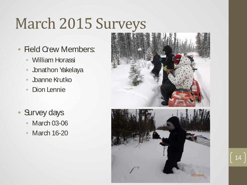
March 2015 Surveys • Field Crew Members:
• William Horassi • Jonathon Yakelaya • Joanne Krutko • Dion Lennie
• Survey days
• March 03-06 • March 16-20
14

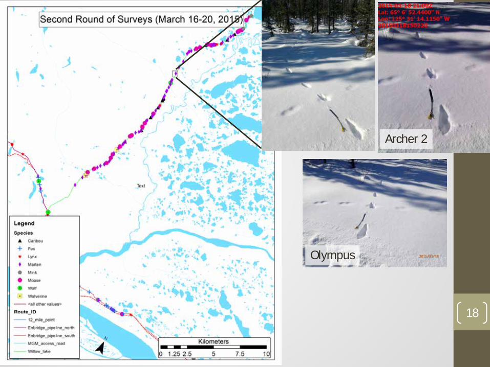
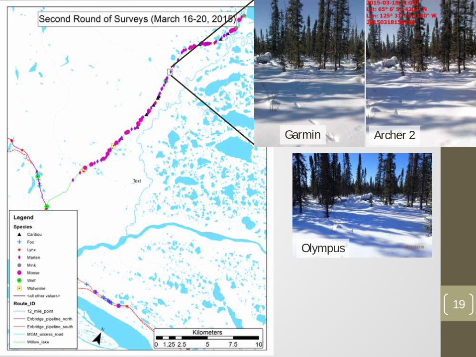
Survey Routes
15
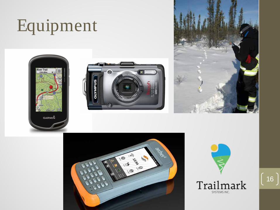
Equipment
16
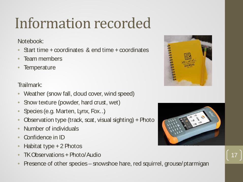
Information recorded Notebook: • Start time + coordinates & end time + coordinates • Team members • Temperature Trailmark: • Weather (snow fall, cloud cover, wind speed) • Snow texture (powder, hard crust, wet) • Species (e.g. Marten, Lynx, Fox…) • Observation type (track, scat, visual sighting) + Photo • Number of individuals • Confidence in ID • Habitat type + 2 Photos • TK Observations + Photo/Audio • Presence of other species – snowshoe hare, red squirrel, grouse/ptarmigan
17
18
Garmin Archer 2
Olympus
19
Archer 2
Olympus
Garmin

Trailmark
20

Trailmark
21

Trailmark
22

Trailmark
23

Data preparation and analysis • Label all of the photos from the Garmin GPS and the Olympus
camera • Combined the data from all three devices • Looked for observations that were missed in the Trailmark
data • Hired a contractor to work on Winter 2015 data and Explor’s
data from 2012/2013 to prepare it for statistical analysis
24

Results • 4 Routes surveyed twice, 1 route surveyed once • 295 observations of wildlife tracks and other signs (scats,
pellets, etc.) • ~2000 geo-referenced photos taken • 15 wildlife species recorded
25

Results
Species
Total Number of Track
Observations
Number of tracks/km/day since last snow
Min Mean Max Caribou 11 0.04 0.13 0.21 Fox 31 0.03 0.19 0.41 Lynx 38 0.03 0.10 0.25 Marten 113 0.07 0.26 0.63 Mink 10 0.02 0.05 0.07 Moose 42 0.03 0.12 0.31 Otter 3 0.01 0.03 0.05 Weasel/Ermine 10 0.01 0.04 0.06 Wolf 7 0.03 0.06 0.11 Wolverine 5 0.04 0.03 0.04 Grand Total 270
26

Methods - Issues
• Photo quality • Location accuracy of different devices • Issues with Trailmark + Archer 2’s • Missed tracks
• 69 out of 295 observations were missed by the person using the Archer 2 (23%)
• Important to survey in teams of 2 with 2 recording devices so if the lead surveyor misses a track the second person can stop and record it.
• How to record animals that travel along the survey route • Accounting for smaller animals (snowshoe hare,
ptarmigan/grouse, red squirrel)
27

Photo quality
28 Archer 2 Garmin Olympus
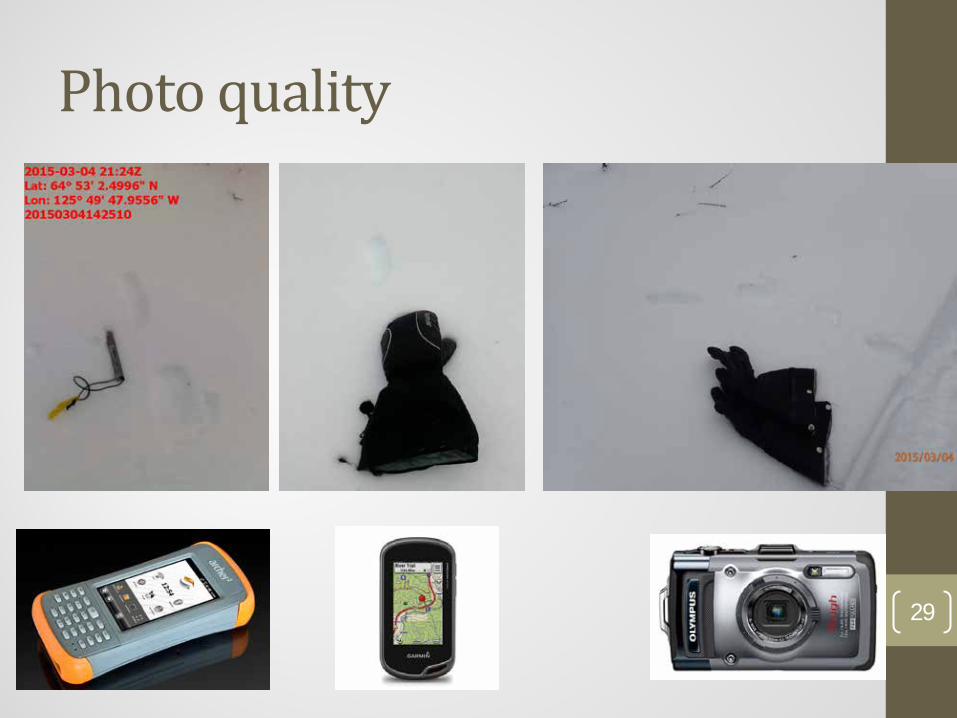
Photo quality
29
Archer 2 Olympus

Location accuracy
30

Location accuracy
31

Distance between coordinates from the same observation
32
Garmin-Olympus
(m)
Olympus-Trailmark
(m)
Garmin-Trailmark
(m) Mean 1,186.4 1,162.6 22.8 Min 0.6 3.1 0.4 Max 38,015.4 38,011.1 761.2 Median 284.0 266.7 4.2
Olympus digital camera did not provide reliable coordinates!!

Trailmark + Archer 2’s • Generally worked as planned • Having all the data entered on the spot is a huge time saver • We had issues with the Trailmark application crashing • Trailmark didn’t provide a complete and continuous GPS track
of the route that was surveyed • Need to have a second person using the Garmin GPS to record
a GPS track and back-up photos
33

Animals that travel along the survey route • How can we record animals that travel along the survey route?

Animals that travel along the survey route • How can we record animals that travel along the survey route?
• Last winter we only recorded where the animal joined the route
35

Animals that travel along the survey route • How can we record animals that travel along the survey route?
• Last winter we only recorded where the animal joined the route • We also need to record how far the animal traveled along the
route by recording where it leaves the route
36

Recommendations for this winter • Continue to work in pairs – one person records with Archer2 +
Trailmark, the other person records with the Garmin GPS • Second person also records tracks the first person misses • Bring the Olympus camera as a back-up device, for recording
video or when a higher quality photo is needed • Add a form to the Trailmark app to record whether an animal
is travelling along the survey route or just crosses it: • Crosses • Along – start (joins trail) • Along – end (leaves trail)
37
Logistics + safety • Gas
• Hours of operation of gas station do not work well with timing of surveys • Difficult to keep track of who is using how much fuel because we often
shared jerry cans • Recommend that monitoring coordinator purchase fuel and fill jerry cans
during the day to fill people up at the end of the day
• Field crew salary and snowmobile rental rates • Salary - $200/day • Snowmobile rental - $150/day
• Safety • Work in teams of 2 • SRRB/ENR should know where each team is going each day and expected
return time • SPOT units (periodic check-ins each day) + Sat phone (in case of emergency) • First aid kit, tool kit, sleeping bag, camp stove, shovel, axe, rope
38

Plans for this winter • Field Crew
• Two teams of 2 people (1 youth / 1 harvester or elder) • 25 work days per person over 4 months (5-6 days/month) • $200/day - salary • $150/day – ski doo rental • Gas costs will be covered by SRRB from CIMP funds
• Survey Coordinator • 1 Person • 4 month part time position • ~12.5 hours per week (200 hrs total) • $20/hour
• Start - December 7 • End – March 31 • Identify up to 6 new survey routes
• interest in trying to sample areas with muskox? • Demos in other Sahtu communities
39

40
Thank You!

41