settlement, erosion and muddy waters · knowledge landscapes & industries settlement, erosion...
TRANSCRIPT

KN
OW
LE
DG
E
Land
scap
es &
Ind
ustr
ies
Settlement, erosion and muddy waters LESSONS FROM THE PAST
Anthony Scott and Jon Olley


Settlement, erosion and muddy waters LESSONS FROM THE PAST
Anthony Scott and Jon Olley
CSIRO Land & Water

Authors: Anthony Scott and Jon OlleyCSIRO Land & Water
Published by: Murray-Darling Basin Commission
Level 5, 15 Moore Street
Canberra ACT 2600
Telephone: (02) 6279 0100
from overseas + 61 2 6279 0100
Facsimile: (02) 6248 8053
from overseas + 61 2 6248 8053
Email: [email protected]
Internet: http://www.mdbc.gov.au
ISBN: 1 876830 39 5
Cover photo: Reproduced courtesy of State Library of New South Wales, Mitchell Library
© 2003, CSIRO, Murray-Darling Basin Commission and The Commonwealth of Australia through the National Land and Water Resources Audit
This work is copyright. Photographs, cover artwork and logos are not to be reproduced, copied or stored by any process without the written
permission of the copyright holders or owners. All commercial rights are reserved and no part of this publication covered by copyright may be
reproduced, copied or stored in any form or by any means for the purpose of acquiring profit or generating monies through commercially exploiting
(including but not limited to sales) any part of or the whole of this publication except with the written permission of the copyright holders.
However, the copyright holders permit any person to reproduce or copy the text and other graphics in this publication or any part of it for the
purposes of research, scientific advancement, academic discussion, record-keeping, free distribution, educational use or for any other public use or
benefit provided that any such reproduction or copy (in part or in whole) acknowledges the permission of the copyright holders and its source
(‘Settlement, Erosion and Muddy Waters’) is clearly acknowledged.
To the extent permitted by law, the copyright holders (including its employees and consultants) exclude all liability to any person for any
consequences, including but not limited to all losses, damages, costs, expenses and any other compensation, arising directly or indirectly from
using this report (in part or in whole) and any information or material contained in it.
The contents of this publication do not purport to represent the position of CSIRO, Murray-Darling Basin Commission or The Commonwealth of
Australia in any way and are presented for the purpose of informing and stimulating discussion for improved management of Basin's natural resources.

Foreword
Moving towards the sustainable
management of the natural resources of
the Murray-Darling Basin requires a clear
understanding of the complex set of
factors that shape the natural and cultural
environment of the Basin.
As our knowledge of surface drainage,erosion and groundwater flow systemsbecomes more sophisticated, naturalresource managers are seeking to betterunderstand the cultural, economic and socialforces that shape our impact on the Basin’snatural resources.
This report presents an overview of howsettlement and agricultural development havechanged the landscape of the Basin over thepast 200 years.
This document draws on two CSIRO Landand Water technical reports and presents anhistorical overview of the major events thatcaused soil and stream bank erosion overthe past two centuries.
This historical review illuminates howeconomics, limited scientific knowledge,exotic pests, climate variability and
government policy have compounded toinitiate major erosion events that have re-shaped the Basin landscape.
Importantly, the report argues that we havefound a new equilibrium, with the overall rateof erosion declining over the past 50 years.However, this still leaves erosion rates manytimes higher than those prior to settlementand development of the Basin.
Researchers, land managers and policymakers will find this report a valuablesummary of the history of the Basin and theforces that have changed the Basinlandscape. The legacy of the past 200 yearswill continue to have a profound influence asthe Basin community works towardsachieving sustainable natural resourcemanagement in the future.
Scott KeyworthDirector, Landscapes & Industries ProgramMurray-Darling Basin Commission
S E T T L E M E N T , E R O S I O N A N D M U D D Y W A T E R S : L E S S O N S F R O M T H E P A S Tiii

S E T T L E M E N T , E R O S I O N A N D M U D D Y W A T E R S : L E S S O N S F R O M T H E P A S Tiv
◆
◆
◆
◆
◆
◆
◆
◆
◆ Tenterfield
◆
Hungerford
◆ Roma
Charleville ◆
Tambo◆
Tara ◆
Stanthorpe
Toowoomba ◆
◆
BRISBANE◆
Goondiwindi
Narrabri
◆ ArmidaleGunnedah
Coonamble
◆ Coonabarabran ◆
Tamworth
Dubbo
Wellington
Forbes
◆ Gundagai
Wagga WaggaDeniliquin
◆
Hay
Balranald
◆ MilduraWentworth
◆
◆
Griffith
◆ SheppartonBendigo
Albury
◆
Bourke
Cunnamulla
Walgett
QUEENSLAND
Lachlan R iver
RIVERMU R R AY
◆
◆ Morven
◆ Dalby
◆
◆ BollonSt George ◆
◆
Leeton
◆
Renmark
Murrumbidgee River Narrandera
Moree
◆
Echuca
◆
Orange
Cowra
◆
◆ Cobar
◆ Young
Yass
Cooma
Seymour
◆ Morgan
◆
Omeo
◆ White Cliffs
◆ Broken Hill
◆ Wilcannia
SYDNEY ◆
MELBOURNE ◆ VICTORIA
NEW SOUTHWALES
Darlin
g River
◆ Ivanhoe
◆
MenindeeLakes
◆ Mannum
Bathurst
Horsham
Swan Hill
◆
Wodonga
Kerang
◆
◆
◆
◆
◆
◆
Chinchilla
◆ Augathella
◆ ◆
◆
◆
◆
◆
Warwick
◆
◆
◆ Wanaaring
◆
Hume Dam
Dartmouth Dam
Lake Victoria
◆
◆
ADELAIDE
SOUTH AUSTRALIA
Lake Alexandrina
◆
0 100 200 km
Goolwa◆
Murray Bridge
CANBERRA
The Murray-Darling Basin is thecatchment for the Murray and DarlingRivers and their many tributaries.Extending from north of Roma inQueensland to Goolwa in South Australia,and including three quarters of New SouthWales (NSW) and half of Victoria,
it is the heartland and the economicpowerhouse of rural Australia.
It extends across one-seventh of the
continent and has a population of nearly two
million people. Another million people outside
the region depend heavily upon its resources.
Source: Australian Geological Survey Organisation.
The Murray-Darling Basin

Introduction
It is said that those who can't learn from the past are forced to repeat it. Soil erosion costs Australia about $500 million every year in lostagricultural production and associatedeffects on water quality. A significantproportion of this cost is from theMurray-Darling Basin. Much of theerosion we see today commenced over200 years ago when European settlersstarted farming the land.
Today, in many areas of the Basin, soilerosion and its effects on our rivers areevident to even the most casual of observers.This includes extensive gully networks,exposed subsoils, dirty waters, dams filledwith silt and river beds drowned in sand.
In the words of Henry Bolte, (1949) Premier of Victoria:
“We could not have made a bigger mess ofthe soil of the country if its destruction hadbeen carried out under supervision.”
This booklet summarises two reports whichexamined the cause and effect of soil erosionin the Basin over the last 200 years and looksat the lessons we can learn from the past.
Sheet and rill erosion associated with a salt scald in Gunning, NSW. Photo: Nicki Taws.
The muddy waters of the Goulburn River, Victoria.Photo: Anthony Scott.
Large quantities of sand deposited in theMurrumbidgee River at Tharwa. Photo: Anthony Scott.
S E T T L E M E N T , E R O S I O N A N D M U D D Y W A T E R S : L E S S O N S F R O M T H E P A S T
1

Evidence uncovered at Lake Mungo in south-western NSW suggests thatAboriginal people have lived in the Basinfor at least 40,000 years, or more than 1,000 generations. Their total populationwas relatively small and sparsely settled,and as subsistence hunter-gatherers, their overall impact on the environmentwas minimal.
Their biggest impact was to change the fireregime, from one of rare, high-intensitynatural fires to one of more frequent low-intensity fires. These fires were used to flushout animals while hunting and to encouragenew growth of grass, which would attractkangaroos and other grazing animals. Thefrequent, low-intensity fires allowed a quickrecovery of vegetative cover and the effectson erosion were minimal.
Descriptions of the Murray-Darling Basin at the time of European settlement arerecorded in the journals and diaries of thefirst explorers and settlers, and also in thereports and maps of government surveyors.Essential to their survival was the availabilityand permanence of water, and hence theirrecords provide detailed descriptions of therivers, streams and waterholes. Thesedescriptions provide evidence of what theylooked like prior to the introduction of thepastoral and agricultural activities of the first settlers.
Early reports indicate that the broad valleys in upland regions often contained swampy
meadows and chains of ponds. Due to thehigh efficiency of these areas as sedimenttraps, sediment transport in these systemswould have been inefficient with flood watersspreading out across the valley floors.
In drier areas along the western slopes,valleys often contained channels which weredry for most of the year, linked to deeperwater holes. Some larger streams had welldefined channels and a semi-permanent flowof water during wetter periods. In the driersemi-arid regions throughout the western half of the Basin, flow was highly erratic anddrainage lines consisted of shallowmeandering sandy streambeds bordered by trees.
Most importantly, detailed studies of historical evidence indicate that thecontinuous networks of deeply eroded gullies, now found in many catchments of the Basin, were not present prior toEuropean settlement.
Inland Rivers
The journals of the first explorers andsettlers also provide quite detaileddescriptions of the inland rivers, includinginformation on aquatic life, river vegetationand water quality. In these reports there arequite frequent descriptions of cobble andgravel bedded rivers with clear flowingwater. This indicates that in many of therivers the supply of fine suspendedsediment was limited, and sedimenttransport generally exceeded the supply ofsand and mud. For instance Sturt, in 1829,described the waters of the MurrumbidgeeRiver at Jugiong, NSW, as “hard andtransparent” and for the Murray Riverwhere it joins the Murrumbidgee, hereported that, “its transparent waters wererunning over a sandy bed.”
The Lachlan River, however, is one river whichappears to have always been more turbid thanmost. Oxley refers to this in 1818 when hecompares the Macquarie River as being:
Prior to European settlement
S E T T L E M E N T , E R O S I O N A N D M U D D Y W A T E R S : L E S S O N S F R O M T H E P A S T2
... detailed studies of historical
evidence indicate that the continuous
networks of deeply eroded gullies
now found in many catchments
of the Basin, were not present prior
to European settlement.

S E T T L E M E N T , E R O S I O N A N D M U D D Y W A T E R S : L E S S O N S F R O M T H E P A S T
3
“in every respect different from the Lachlan; itswaters are pure and transparent.” The DarlingRiver was also often described as muddy. In1829 Sturt compared the Murray and DarlingRivers at their junction:
“There was as distinct a line between theirrespective waters, to a considerable distancebelow the junction, as if a thin board aloneseparated them. The one half of the channelcontained the turbid waters of the northernstream, the other still preserved their originaltransparency.”
Although many of the reports by earlyexplorers and settlers indicate that the riversof the Murray-Darling Basin were less muddythan in present times, heavy rainfall couldquickly change their appearance, as Oxleydiscovered when camping on the banks ofthe Castlereagh River in 1818:
“The river during the night had risen upwardsof eight feet; and still continued rising withsurprising rapidity, running at the rate of fromfive to six miles per hour, bringing down withit great quantities of driftwood and otherwreck. …. The water was so extremelyturbid, that we could not use it; but wereforced to send back to the marshes for whatwe wanted. .... Now the quantity of matter isastonishing, and such as must take someyears to remove.”
Prior to European settlement many of therivers within the Murray-Darling containedless turbid water, due to the lower supplyof fine sediment from the uppercatchments. Most of the rivers alsocontained numerous freshwater fish, a good indication of a healthy aquaticenvironment.
In pre-European times many streams in the Southern Tablelands contained chains of ponds similar to this. Photo: Ian Prosser.
... the journals
and diaries of the
first explorers and
settlers ... provide
evidence of what
drainage lines
looked like prior
to the introduction
of the pastoral and
agricultural activities
of the first settlers.

By 1850 there were
more than 12 million
sheep grazing the whole
of south-eastern
Australia … and the first
signs of landscape
change were observed.
Although the First Fleet arrived at PortJackson (Sydney) in 1788, it was not until1813 that the explorers Blaxland, Lawsonand Wentworth crossed the BlueMountains and established a gateway tothe interior of New South Wales.
Initially, settlers were slow to follow in thefootsteps of these explorers, and in 1819,there were only about eight settlers in theBathurst district, along with 24 flocks ofsheep and about 1,400 head of cattle. Bythe 1820s, however, explorers such asHume and Hovell, Cunningham and Sturtwere discovering new lands to the south,west and north of Port Jackson, andsettlers were following soon after. Thepastoral expansion of the colony hadcommenced.
This phase of exploration and settlementexpanded rapidly in the 1830s, with ThomasMitchell conducting expeditions into thenorth-west of NSW in 1831 and 1832, andthen in 1836 travelling through south-westNSW and into western Victoria. Withinmonths of Mitchell’s return, squatters withlarge herds of cattle and flocks of sheepfollowed his tracks to the new pastoral lands.By 1840, squatters had establishedthemselves in a continuous belt from PortPhillip in the south, sweeping up between theLachlan River and the coast, to the DarlingDowns in the north.
In 1821 NSW had only 139,000 sheep,essentially producing meat for a restrictedlocal market, but by 1850 there were morethan 12 million sheep grazing acrosssouth-eastern Australia. This expansionrequired little capital apart from livestockitself. Land cost either nothing or a nominalamount for a lease, instead of buildingfences shepherds were employed, andaccommodation was primitive. Initially therewas ample land and the runs must havebeen lightly stocked. However, stocknumbers increased rapidly and the firstsigns of landscape change were observed.
The pastoral system meant that up to 2,000 sheep were gathered together eachnight, on an area rarely exceeding ahectare, for several nights at a time. This created severely trampled and bareareas of one or two hectares in extent.Cattle were not held in closely bunchedherds, and therefore generally spread outmore than sheep. However, the cattletended to feed along the moister valleyfloors where disturbance to sensitivevegetation in swampy meadows and alongstreamlines was greatest.
S E T T L E M E N T , E R O S I O N A N D M U D D Y W A T E R S : L E S S O N S F R O M T H E P A S T4
Explorers and squatters
Settlement of the Murray-Darling Basin from 1830 to 1860. Source: CSIRO.

S E T T L E M E N T , E R O S I O N A N D M U D D Y W A T E R S : L E S S O N S F R O M T H E P A S T5
The gold rush era
In 1851, Edward Hargreaves discoveredgold in a creek at Ophir, not far fromBathurst, NSW. This led to a rush andwhen gold was discovered at numeroussites in the uplands and slopes of NSWand Victoria, tens of thousands of peopleflocked to these goldfields, hoping tomake their fortune.
The mining activities and associatedsettlements quickly degraded the streamsand surrounding countryside. The initialphase of mining involved individuals or small groups digging and washing soil from shallow alluvial deposits along rivers and streams. This required a great deal of water to sort the gold from the washdirtusing small wooden puddling tubs, cradles and pans.
Later, horse-driven puddling machineswere introduced wherever a sufficient watersupply was available. The creek beds wereoften so ravaged that the evidence can stillbe seen today. In some instances theentire stream was diverted so that thesediment in the stream bed and bankscould be processed more easily. Beautifulvalleys were stripped bare of soil, whichwas processed in the puddlers and thenflushed downstream. Vast quantities ofsludge moved down the valleys, frequentlyblocking the natural watercourses anddepositing on the lower floodplains.
Where the source of gold was traced tounderlying rocks, companies were formed to sink deep shafts. The underground mining industry produced huge quantities
A miner sluicing for gold along a creek in the Castlemaine district in 1894. Photo: Reproduced courtesy ofMuseum of Victoria.
S E T T L E M E N T , E R O S I O N A N D M U D D Y W A T E R S : L E S S O N S F R O M T H E P A S T6
of waste and sludge which flowed intonearby streams.
Gold mining also created a huge appetite fortimber, and the surrounding forests rapidlydisappeared. Initially timber was used forfirewood and for building shelters, but whenunderground mining commenced in the1860s, timber was also needed as boiler feedand as props in mineshafts. Throughout thegold mining districts, particularly CentralVictoria, hundreds of square kilometres offorest disappeared, leaving the fragile soilsprone to surface and gully erosion.
With advances in technology during thelatter half of the 19th century, a secondphase of mining occurred. Hydraulic miningwas introduced into Victoria’s north-easternfields by Californian miners. Its mostdevastating procedure involved theundercutting of hillsides and steep streambanks down to bedrock, using powerfulwater jets.
In the early 20th century giant dredgeswere also being used to rework enormousquantities of sediment both in the riverbeds and on the floodplains. Largequantities of fine sediment were dischargedinto the river system.
Sediment from mining and dredgingcontributed towards the in-filling ofLaanecoorie Reservoir on the LoddonRiver. Constructed in 1891, the initialcapacity of 17,000 ML was reduced byover half during its first 41 years ofoperation.
Throughout the gold mining districts …hundreds of square kilometres of forest
disappeared, leaving the fragile soils prone to surface and gully erosion.
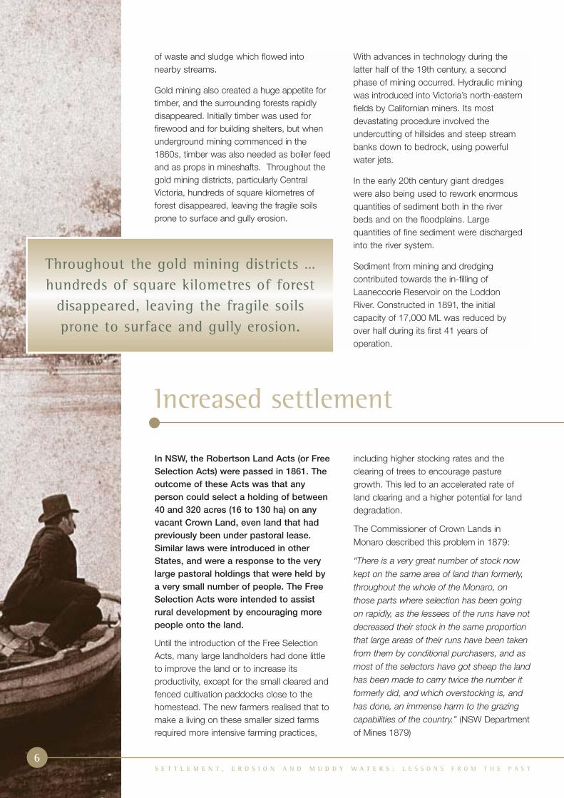
In NSW, the Robertson Land Acts (or FreeSelection Acts) were passed in 1861. Theoutcome of these Acts was that anyperson could select a holding of between40 and 320 acres (16 to 130 ha) on anyvacant Crown Land, even land that hadpreviously been under pastoral lease.Similar laws were introduced in otherStates, and were a response to the verylarge pastoral holdings that were held bya very small number of people. The FreeSelection Acts were intended to assistrural development by encouraging morepeople onto the land.
Until the introduction of the Free SelectionActs, many large landholders had done littleto improve the land or to increase itsproductivity, except for the small cleared andfenced cultivation paddocks close to thehomestead. The new farmers realised that tomake a living on these smaller sized farmsrequired more intensive farming practices,
including higher stocking rates and theclearing of trees to encourage pasturegrowth. This led to an accelerated rate ofland clearing and a higher potential for landdegradation.
The Commissioner of Crown Lands inMonaro described this problem in 1879:
“There is a very great number of stock now
kept on the same area of land than formerly,
throughout the whole of the Monaro, on
those parts where selection has been going
on rapidly, as the lessees of the runs have not
decreased their stock in the same proportion
that large areas of their runs have been taken
from them by conditional purchasers, and as
most of the selectors have got sheep the land
has been made to carry twice the number it
formerly did, and which overstocking is, and
has done, an immense harm to the grazing
capabilities of the country.” (NSW Departmentof Mines 1879)
Increased settlement

S E T T L E M E N T , E R O S I O N A N D M U D D Y W A T E R S : L E S S O N S F R O M T H E P A S T
7
Severe erosion of pastoral land near Wellington, NSW, in 1960. Photo: Reproduced courtesy of Mitchell Library.
The sinking of wells, construction of earth
dams and erection of galvanized tanks in
the late 1860s enabled the drier western
half of the Basin to be stocked on a more
permanent basis. The most spectacular
developments were achieved following the
discovery of groundwater in the Great
Artesian Basin in 1879, which had the
effect of opening up the north-west of
NSW and the south-west of Queensland.
In the 1860s the railway system started to
expand rapidly from Melbourne, Sydney
and Brisbane and by the 1890s most
large towns in the Murray-Darling Basin
were connected by a network of railway
lines. With better transport and prices,
wool production became an increasingly
popular rural enterprise, and outstripped
beef and sheep meat production.
RingbarkingFrom the 1870s onwards, pastoralists startedto use ringbarking (the removal of a ring ofbark to kill the tree). William Farrer was onewho, in 1873, promoted ringbarking as thecheapest and easiest method of improvingpasture growth by the removal of competitionof trees for soil, water and sunlight. In anumber of districts travellers, no longer ableto make a living from gold mining, offeredtheir services as cheap and hard-workingcontractors for ringbarking.
… overstocking is, and has done,
an immense harm to the grazing
capabilities of the country.

The introduction of railways in the late 19thcentury opened up the NSW westernslopes and plains to cropping. In 1860,91% of wheat growing in NSW was on thecoast and Tablelands; by 1890, 71% wasgrown on the slopes and plains. However,crop yields declined and by 1902 wheatyields in south-eastern Australiaplummeted to about one third (ie 0.5 t/ha)of yields obtained a few decades earlier.The practice of frequent cropping withoutadequate fallow encouraged soil-bornediseases, and the lack of fertilisers (orrotation with nitrogen fixing crops) reducedthe supply of available nutrients.
From its high point in 1891 the woolindustry also started to slump.Overgrazing and the arrival of devastatingrabbit plagues in the mid-1880s causedproblems, but it was the prolongeddrought, coupled with a severe economicdepression in the second half of the1890s, that triggered the collapse of thepastoral industry. Overstocking, particularlyin the western districts of the Basin,resulted in severe soil erosion and thespread of salt-scalded plains. Manygraziers went broke and their pastoralleases were passed on to the banks orlarger pastoral companies. Evidence to aNSW Royal Commission in 1901 provideda graphic description of huge areas ofwindswept and scalded land in thewestern districts, with sand drift coveringfences, water troughs, stock-yards andeven silting up earthen tanks. Extensiveareas of edible saltbush and bluebush,often found on the more erodible soils,were also wiped out.
By 1900 many of the forests and
woodlands throughout the Murray-Darling
Basin, particularly in the highlands and
western slopes of the Basin, had been
ringbarked or cleared to improve
productivity for grazing. The deep-rooted
perennial grasses also slowly disappeared
under the heavy grazing pressure,
and were replaced by faster growing
annual grasses which have a shallower
root system.
The overall effects of clearing and grazing
increased the amount and speed of
surface runoff, and removed most of the
binding effects of root systems. This led to
accelerated rates of erosion, particularly
along drainage lines where cattle tended
to congregate and trample the stream
bank vegetation. Other factors, such as
the ploughing of hill slopes, digging
channels to drain swampy meadows, the
construction of roads, and the formation
of animal tracks, often accelerated the
erosion process by disturbing the soil and
concentrating the surface flow along
a particular line.
In September 1892, the academic,
A.G. Hamilton, wrote a paper presented
to the Royal Society of NSW, which
described the erosion process:
“In clearing land and during the progress
of settlement, the surface of the ground is
injured in many ways; in the formation of
paths and roads; and in ploughing the
ground. When the surface is broken on
a slope, no matter how gentle, the
protection afforded by the grasses and
herbaceous plants to the soil is removed
and the surface drainage is altered. Small
runlets of water begin to travel along the
line of disturbance and to cut channels
which become deeper and deeper. The
amount of earth cut away of course
depends greatly on the slope, the nature
of the soil and the amount of rainfall; being
greatest in light soils and on steep slopes.
In a light sandy soil I have seen on a very
slight slope, channels nine feet deep and
twelve or fourteen feet wide cut in a single
wet winter.”
S E T T L E M E N T , E R O S I O N A N D M U D D Y W A T E R S : L E S S O N S F R O M T H E P A S T8
By 1900 many of the forests and
woodlands throughout the Murray-Darling
Basin, particularly in the highlands and
western slopes of the Basin, had been
ringbarked or cleared to improve
productivity for grazing and cropping.

S E T T L E M E N T , E R O S I O N A N D M U D D Y W A T E R S : L E S S O N S F R O M T H E P A S T
9
Gully erosion near Gulgong, NSW, 1945. Photo: Reproduced courtesy of Mitchell Library.
It is assumed that Hamilton’s
understanding of erosion processes
was gained through direct observation.
The statement describes the creation
of a small rill, and concentration of flow
to form a gully.
The massive increase in erosion was also
affecting the rivers, and some academics
were expressing concern as early as 1865:
“Mining, ploughing, roadmaking, the
cutting of drains, the formation of tracks,
all aid in diminishing the conservative
powers of the natural herbage, and it is
not surprising that our best streams, such
as the Loddon, Campaspe, and Avoca,
are fast becoming mere channels for the
efflux of sludge and sand. Even in those
parts not touched by the gold-miner, therivers are rapidly changing their character.The mere occupation of the country forpastoral purposes has produced greatchanges, and it is well to consider whetheranything can be done to compensate for,if we cannot check, this kind ofdevastation. The reservation of large tractsof forest land is our first duty,” (The Argusnewspaper, 1865, Melbourne).
Despite the far-sighted statements by a few academics and scientists, theprimary aim of the State Governmentswas for rural development and the clearingof land in pastoral and agricultural districtsto continue unrestricted through thesecond half of the 19th century and early20th century.

S E T T L E M E N T , E R O S I O N A N D M U D D Y W A T E R S : L E S S O N S F R O M T H E P A S T10
Prior to European settlement, the western slopes of the Murray-Darling Basin contained large areas of grassywoodland. Today, only small remnants remain, such as this reserve near Tarcutta, NSW. Photo: Nicki Taws.
Although rabbits had been introduced toAustralia previously, it was the wild greyrabbits that Thomas Austin, a farmer nearGeelong, Victoria, brought out fromEngland in 1859 that acclimatised sosuccessfully and rapidly spread throughoutthe countryside. In 1865 Austin had 20,000rabbits on his property, and by 1874 theywere spreading north into the Wimmeraregion. By the end of the 1870s, they hadcrossed the border into South Australia andby 1880 were across the Murray River andheading north through NSW. By 1886 theywere reported in Queensland.
Many farmers erected netting along theboundaries of their properties and usedpoisoning, trapping and shooting to kill therabbits. However, in most districts of the Murray-Darling Basin, rabbits had reached plagueproportions by the 1890s and early 1900s.
The main effect of the rabbit was to increasethe overgrazing already being caused by thesheep and cattle during dry periods. This leftthe land bare and prone to erosion from windor water. In the semi-arid zone, rabbits alsoringbarked edible trees and contributed tothe loss of perennial grasses and bushes.
Rabbit plagues continued throughout the firsthalf of the 20th century, and were particularlybad after World War II in the late 1940s.Farmers and graziers had been away at thewar, unable to carry out normal trapping,shooting and poisoning, and rabbits swarmedacross the countryside. This scene changed in1950 when the myxoma virus was introducedto control the rabbit population.
Myxomatosis reduced the rabbit populationvery markedly, especially in the better wateredareas of the Basin. In areas where the grazingpressure from rabbits declined, the increasedground cover helped protect the soil surfacefrom erosion.
Rabbits
Farmhouse and shearing shed near Corowa, NSW,surrounded by bare ground, denuded by rabbits.Picture: by Robert Ingpen, from McKay 1976.Reproduced courtesy CSIRO.

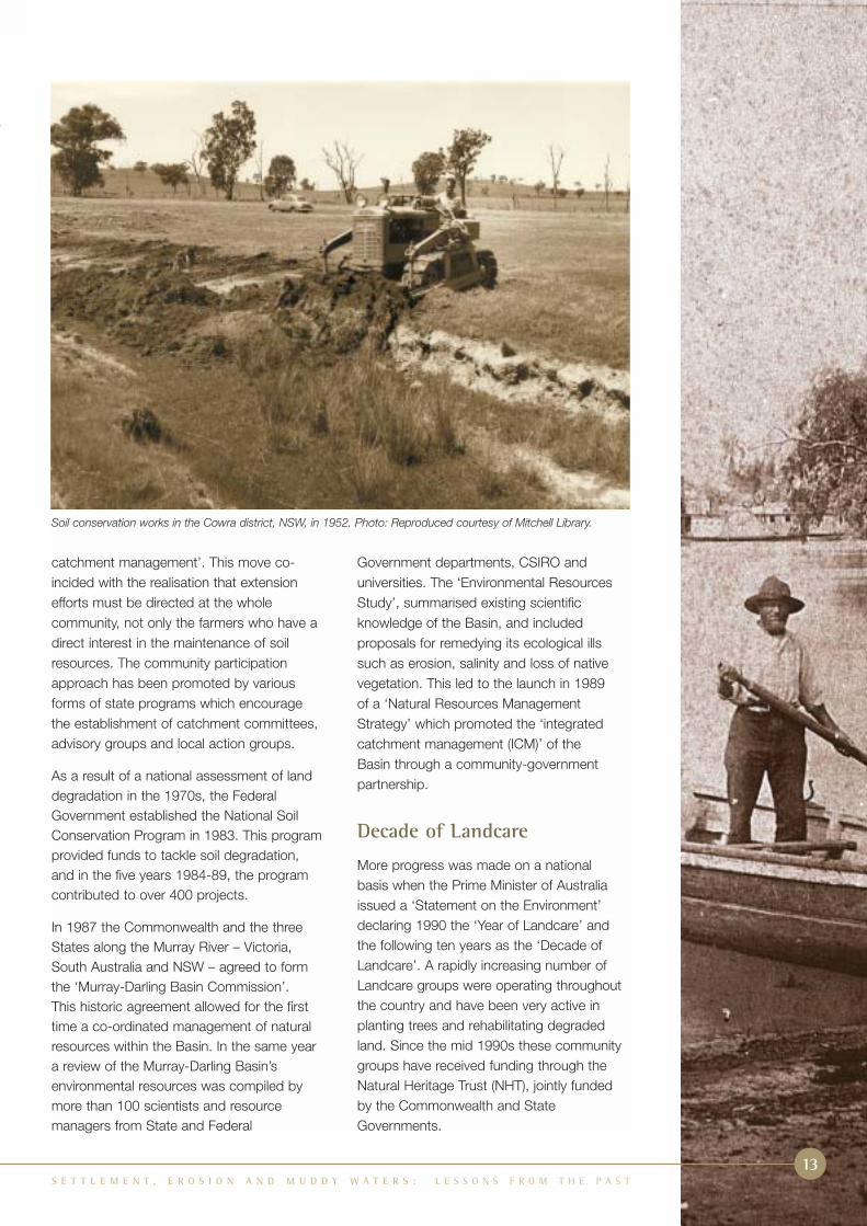
Soil conservation campaign
In the late 1920s, Sam Clayton, a seniorofficer of the NSW Department ofAgriculture, became acutely aware of theserious soil erosion throughout the wheatlands in the western slopes of the Basin.Despite reservations from many of hiscolleagues, he began constructingcontour banks in eroded wheat paddocksat the Cowra Experimental Farm todemonstrate the principles of soilconservation to farmers. In 1930 Claytonorganised the first soil conservation fieldday in Australia, and then continued hiscampaign by holding lectures in countrytowns and writing articles for newspapersand the Agricultural Gazette.
In the 1920s, there was increasing concernabout the siltation of reservoirs, and in 1925the River Murray Commission requested thataction be taken to prevent destruction offorests in the catchment of the Hume Dam –the major water storage on the Murray River.
A series of droughts in the late 1920s and1930s intensified wind erosion throughoutthe western plains of the Basin, and public
awareness increased dramatically as hugedust storms moved across eastern Australia.The growing realisation of the importance ofsoil erosion in relation to the nationaleconomy led to agitation by various publicorganisations, government departments andmembers of Parliament. In August 1936, soilerosion was one of the subjects discussedby a conference of Commonwealth and StateMinisters in Adelaide. The conferencedecided that all State Governments shouldbe asked to form soil erosion committees.
The social climate was now ready for somemajor government initiatives to combat soilerosion, and in 1933 a soil conservation billwas passed in the NSW Parliament, leadingto the formation of the first Soil ConservationService in Australia.
Similar bills were passed in South Australia in 1939, Victoria in 1940 and Queensland in 1951. After a little more than a century ofcontinuous degradation of the soil and waterresources, governments began taking stepsto address the problem.
In the last few decades of the 19th centurythe development of a railway networkprovided better access to markets and withthe introduction of new strains of wheat,there was a rapid expansion of croppingthroughout the Basin. In South Australia andNew South Wales, the wheat frontier waspushed well beyond its present limits, butoften with disastrous results, particularlyduring the drought of the 1890s. At this time,the farming frontier was steadily changingmassive areas of grassland, mallee scruband open woodland into cropland.
From the early 1880s to the 1920s, the useof ‘bare fallow’ in wheat production toincrease soil moisture, break down organicmatter, and to control weeds, was activelypromoted by the State departments ofagriculture. However, on sloping land this
technique left the soils exposed to the forcesof running water. Every storm had thepotential to remove large quantities of topsoil.In a few hours of heavy rain, soil that hadtaken many thousands of years to form, waswashed off the paddocks and down thenearest stream. Similarly, on the plains, theloosened topsoil was quickly removed andcarried away by strong winds.
For instance, heavy rainfall in the summers of 1927-1930 caused severe erosion in thewheat growing areas in the south-westslopes of New South Wales:
“Land that ten years ago could be cultivatedand drilled across is now in many instancescut by gullies 7 and 8 feet deep and 9 and10 feet wide. The damage has to be seen tobe believed.” (Clayton 1931).
The expansion of cropping
S E T T L E M E N T , E R O S I O N A N D M U D D Y W A T E R S : L E S S O N S F R O M T H E P A S T
11

In the late 1940s and early 1950s, initialsoil conservation efforts were centredaround the construction of mechanicalprotection works and rehabilitation ofindividual paddocks.
Demonstration sites were set up and a major education campaign was carried out in the early 1950s. Field days on thesedemonstration sites were particularlysuccessful with up to 800 people attending. The success of these field daysplayed a large part in the promotion ofextension programs.
It soon became apparent that soilconservation works needed to be co-ordinated over the whole farm. This led
to the development of whole farm planning. The first step involved a survey of soil types,vegetation, existing erosion and history ofland use. The plan included changes in landuse, relocation of paddock boundaries to conform with various land classes and,if needed, construction of mechanical worksto arrest erosion.
The next step was to develop plans for largercatchment areas covering many properties.This approach was adopted in Queensland in the mid 1950s, and by 1959 catchmentplans covering 80,940 hectares had beenprepared. The first co-operative project inVictoria was started near Stawell in 1952,and by 1961, 39 co-operative projects werein operation. These projects were aimedentirely at erosion control and were often setup to protect the catchments of major watersupply reservoirs. Similar projects were setup by the NSW Soil Conservation Service toprotect the catchments of major watersupply reservoirs throughout the State.
In NSW the move to planning soilconservation and land resource managementactivities on a whole catchment basisbecame known in the 1980s as ‘total
Improved management
Contour banks to reduce streamflow velocities and trap sediments are part of improved management plans.Photo: Anthony Scott.
S E T T L E M E N T , E R O S I O N A N D M U D D Y W A T E R S : L E S S O N S F R O M T H E P A S T12
As a result of a national assessment
of land degradation in the 1970s,
the Federal Government established
the National Soil Conservation
Program in 1983.
S E T T L E M E N T , E R O S I O N A N D M U D D Y W A T E R S : L E S S O N S F R O M T H E P A S T13
Soil conservation works in the Cowra district, NSW, in 1952. Photo: Reproduced courtesy of Mitchell Library.
catchment management’. This move co-incided with the realisation that extensionefforts must be directed at the wholecommunity, not only the farmers who have adirect interest in the maintenance of soilresources. The community participationapproach has been promoted by variousforms of state programs which encouragethe establishment of catchment committees,advisory groups and local action groups.
As a result of a national assessment of landdegradation in the 1970s, the FederalGovernment established the National SoilConservation Program in 1983. This programprovided funds to tackle soil degradation,and in the five years 1984-89, the programcontributed to over 400 projects.
In 1987 the Commonwealth and the threeStates along the Murray River – Victoria,South Australia and NSW – agreed to formthe ‘Murray-Darling Basin Commission’. This historic agreement allowed for the firsttime a co-ordinated management of naturalresources within the Basin. In the same yeara review of the Murray-Darling Basin’senvironmental resources was compiled bymore than 100 scientists and resourcemanagers from State and Federal
Government departments, CSIRO anduniversities. The ‘Environmental ResourcesStudy’, summarised existing scientificknowledge of the Basin, and includedproposals for remedying its ecological illssuch as erosion, salinity and loss of nativevegetation. This led to the launch in 1989 of a ‘Natural Resources ManagementStrategy’ which promoted the ‘integratedcatchment management (ICM)’ of the Basin through a community-governmentpartnership.
Decade of Landcare
More progress was made on a nationalbasis when the Prime Minister of Australiaissued a ‘Statement on the Environment’declaring 1990 the ‘Year of Landcare’ andthe following ten years as the ‘Decade ofLandcare’. A rapidly increasing number ofLandcare groups were operating throughoutthe country and have been very active inplanting trees and rehabilitating degradedland. Since the mid 1990s these communitygroups have received funding through theNatural Heritage Trust (NHT), jointly fundedby the Commonwealth and StateGovernments.

S E T T L E M E N T , E R O S I O N A N D M U D D Y W A T E R S : L E S S O N S F R O M T H E P A S T14
After reaching a peak in the late 19th
century and early 20th century, soil
erosion throughout much of the Murray-
Darling Basin appears to be slowly
declining and the landscape is gradually
adjusting towards a new ‘equilibrium’.
However, these new rates of erosion are
still many times higher than those of pre-
European times, and the legacy of the
past 200 years continues to have a
significant impact on both the
environment and agricultural productivity.
There are a number of reasons why the
overall rate of erosion (in particular gully
erosion) within the Basin has declined over
the past 50 years:
Adjusting to the new landscape. After initial
incision, followed by deepening and
widening, many gully networks have adjusted
to the increased rates of surface runoff and
are now gradually stabilising, and in some
areas revegetating with wetland plants.
Better land management has increased the
protective ground cover. This has included
lower stocking rates, pasture improvement,
and the replacement of conventional tillage
with conservation farming practices.
Reduction in rabbit numbers. Myxomatosiswas introduced in 1950 and it reduced therabbit population very markedly, especially inthe better watered areas of the Basin.However, less virulent strains of the virusappeared very rapidly, enabling the rabbitpopulation to gradually acquire a degree ofresistance to the disease. In 1996 theintroduction of rabbit calicivirus reducedrabbit numbers to low levels in the drierregions of the Basin but it had less effect inthe cooler, wetter regions.
Erosion control works. Since the 1940s,many farmers have started to build contourbanks, and repair eroded gullies, with theassistance of State soil conservationagencies. Education programs have alsohelped increase awareness of soil erosionand its impact on farm productivity.
Changes in weather patterns. Long termchanges in the weather patterns haveresulted in increased rainfall over the last 50years. It has been suggested that this mighthave caused an increase in pasture coverand hence better protection of the soil.However, an analysis of weather data for theperiod 1910 to 1995 indicates that someregions have also experienced increases inheavy rainfall, which is when the greatest
A new equilibrium
Soil conservation is now regarded as anecessary part of farm and catchmentmanagement. The implementation of soilconservation measures is also anaccepted initial step when developing newland for cropping. In established areas,contour bank systems, stubble mulchingand minimum tillage are now an integralpart of farming. Agencies prepare co-ordinated plans for whole catchmentsusing information such as topography,land use, soil types and location ofexisting erosion. Research and field trialscontinually refine knowledge andeducation programs for both farmers andthe general community. Forming contour banks to prevent further erosion.
Photo: Reproduced courtesy of Museum of Victoria.

S E T T L E M E N T , E R O S I O N A N D M U D D Y W A T E R S : L E S S O N S F R O M T H E P A S T15
Figure 1: Estimated trend in sediment yield since the 1820s, for Jerrabomberra Ck, southern NSW. Source: RJ Wasson.
Sed
imen
t yie
ld (
t/yr)
Calendar years
1800
0
10
100
1000
1820 1840 1860 1880 1900 1920 1940 1960 1980 2000
erosion tends to occur. The new equilibriumfor soil erosion in the Basin can be seen inFigure 1.
Erosion incidents continue. Although thereis a general decline in erosion ratesthroughout the Basin, in some catchmentsheavy rainfall causes the collapse of unstablegully walls or stream banks and movessediment that has been deposited along thegully floors further downstream. Incatchments where poor land managementpractices continue, or recent land clearinghas occurred, incision and extension of newgully networks remains a serious problem. In some districts there has been a trend toconvert previously cleared pastoral countryinto cropping land. The erosion rates fromcropped land can be tens or hundreds oftimes higher than that from native orimproved pasture.
Although most areas cleared long ago areshowing signs of stabilisation, there are somecatchments which have eroded badly in thelast few decades, and continue to supplyhigh sediment loads to rivers and streams. In other parts of the Basin, land clearing hascontinued into the latter half of the 20thcentury and these areas will remain unstablefor many decades to come. In some districts,particularly in the western slopes of theBasin, the continuing trend of converting
pastoral land to cropping land will also resultin increasing rates of erosion. In theseregions riparian ‘buffer strips’ can be used totrap the sediment in surface runoff before itcontaminates the nearby rivers and streams.
The sequence of erosion events in theMurray-Darling Basin is summarised as a timeline on pages 16 and 17.

Erosion in the Basin – key events
S E T T L E M E N T , E R O S I O N A N D M U D D Y W A T E R S : L E S S O N S F R O M T H E P A S T16
Pre-1813 Aboriginal people had been inhabiting the Basin for over 40,000 years. Their totalpopulation was small and sparsely settled, and as subsistence hunter-gatherers, theiroverall impact on the environment was minimal. Streams had a good cover of aquaticplants and grasses along their banks and showed little sign of erosion.
1813 Blue Mountains were crossed by Blaxland, Lawson and Wentworth. This marked thebeginning of an era of exploration, settlement and exploitation of the Murray-DarlingBasin by European Australians.
1820s and 1830s Exploration of the Murray-Darling Basin by explorers such as Hume and Hovell, Sturt,Oxley, Mitchell and Cunningham travelled throughout the Basin, opening it up to the firstsettlers who quickly followed in their footsteps.
1830s and 1840s Squatting was in full swing and settlers rapidly took up land throughout the eastern half of the Basin. Large herds of sheep and cattle were established, and the first impacts from these hard hoofed animals commenced, such as overgrazing of pastureand the trampling of stream banks. Grazing caused the deep rooted perennial grasses to be slowly replaced by faster growing annual grasses with a shallower root system. In these first years of settlement, there was only minimal clearing of trees from thelandscape.
1840s Settlement of the western half of the Basin commenced, initially along the waterfrontsof the major rivers.
1850s and 1860s Gold rushes attracted thousands of gold miners who initiated the destruction of alluvialland throughout much of central Victoria and in scattered sites along the Tablelands andslopes of NSW. Large scale timber cutting for firewood, housing and for props inmineshafts, caused major loss of forests around the gold fields. These disturbancesinitiated severe gully erosion and caused massive increases in sediment loads downsome rivers, particularly in Victoria.
1860s Closer settlement of rural areas was encouraged by State Governments through a series of Land Acts. This resulted in smaller farms, higher stocking rates andaccelerated land clearing. Evidence of land degradation on some farms was starting to become apparent, particularly during dry spells when the soil was bare. From the1870s onwards, pastoralists started to use ringbarking as a quick and cheap way ofclearing the land.
mid 1860s Rapid land clearing was a growing concern expressed by a few scientists andacademics. The primary concern was about the perceived effect of land clearing onrainfall and water supply in streams. These concerns eventually prompted the creation ofsome timber reserves, but had no effect on the rate of clearing in pastoral andagricultural districts.
1870s A sequence of wet years encouraged pastoral settlement on the back blocks andheavy grazing of perennial plant species, such as saltbush. By 1870 pastoralists hadestablished themselves on the best pastures and waterholes of every large river in theBasin, including the Paroo and Bulloo Rivers in Queensland. These properties weremarginal and not viable during drought. By 1875 virtually all land in the western half ofthe Basin had been granted under lease.
Rabbits spread throughout the Basin and reached plague proportions by the 1890s. Thisincreased the grazing pressure on the land, leaving it prone to erosion during heavy rainfallevents, particularly after droughts when grass cover was at its lowest.
1880s onwards Cropping expanded across massive areas of grassland, mallee scrub and openwoodland. Between the 1880s and 1920s the use of ‘bare fallow’ was actively promotedby the State departments of agriculture. This left the bare, loose soil exposed to severeerosion during heavy rainfall. In the mallee districts, the loosened soil was also carriedaway by strong winds.

S E T T L E M E N T , E R O S I O N A N D M U D D Y W A T E R S : L E S S O N S F R O M T H E P A S T17
1895-1903 Severe and extended drought combined with rabbit plagues and overgrazing causedextensive land degradation, particularly in the semi-arid regions. Many graziers went broke andtheir pastoral leases were passed on to the banks or to larger pastoral companies. Evidence toa Royal Commission in NSW in 1901 provided a graphic description of huge areas ofwindswept and dry, scalded land, with sand drifts covering fences, water troughs andstock yards, and silting up earthen tanks. Extensive areas of edible saltbush were wipedout.
1920s ‘Soldier Settlement Schemes’ were set up after World War I, as an extension of StateGovernments’ closer settlement policies. The allotments were often unsuitable for small-scale farming and could not sustain a family. These attempts at closer settlement placedgreat pressure on the land and resulted in further land degradation.
1920s and 1930s Erosion problems became a growing concern amongst members of the farming andscientific communities. These groups started to question whether increased crop yieldscould be sustained when the basic resource upon which they depended, the soil, wasbeing washed and blown away. There was also a slow but increasing awareness that thecapacities of some water storage dams were being threatened by high rates of siltation.
1930 Australia’s first soil conservation field day was held near Cowra.
1930s and 1940s Drought and associated dust storms, particularly in the mallee of NSW, Victoria andSouth Australia, highlighted the severe problems of erosion to the general public. Thisplaced greater pressure on the State Governments to take action.
Late 1930s and Soil Conservation Acts were introduced by most states, along with advisory 1940s committees within the departments of agriculture or separate soil conservation agencies,
to assist farmers with the control of soil erosion.
1945 onwards Improved soil conservation measures were implemented by farmers, with theassistance of soil conservation officers. Initially this consisted of the construction ofmechanical protection works in eroded gullies and the use of contour banks. This slowly developed into ‘whole farm planning’ and later to the rehabilitation of wholecatchments.
1950s Introduction of myxomatosis reduced rabbit numbers. However, the rabbit populationslowly developed resistance. (In 1996 the Calicivirus further reduced numbers.)
1980s ‘Total catchment management’, as a concept, was introduced, recognising the manyland degradation issues being faced by farmers that needed to be addressed on acatchment basis.
1990s ‘Year of Landcare’ (1990) and ‘Decade of Landcare’ (1991-2000) became thecornerstone of the Prime Minister of Australia’s 1989 ‘Statement on the Environment’.Landcare groups operated throughout the Murray-Darling Basin, actively planting treesand rehabilitating degraded land.
Today Land clearing in the western slopes of the Basin, to convert pastoral land to cropping,increases the rate of erosion in affected catchments. Today, many of the areas clearedduring the 19th and 20th centuries are gradually stabilising, as land managementpractices change, and the rates of erosion are slowly declining from their peaks.However, the current levels of erosion are still many times higher than those of 200 yearsago. The legacy of two centuries of settlement continues to have a significant impact onboth the environment and agricultural productivity.

S E T T L E M E N T , E R O S I O N A N D M U D D Y W A T E R S : L E S S O N S F R O M T H E P A S T18
Recent tree planting and fencing along an erosion gully on a property near Bendigo in Central Victoria. In recentyears, Federal and State funds, through community organisations such as Landcare groups and GreeningAustralia, have assisted farmers with such work. Photo: Anthony Scott.
Lessons from the past
The past 200 years has demonstrated
that many of the imported European
agricultural practices have been
unsuitable for the soils and climate
of the Murray-Darling Basin. Short-term
productivity was achieved at the
expense of long-term sustainability.
Improved farming practices that protect thesoil from erosion are now being adoptedon many farms throughout the Basin. Thisincludes practices such as maintainingvegetation cover, avoiding overgrazing andminimising tillage. In some regions,however, long-term sustainability mightonly be achieved by replacing existing landuses with alternative farming enterprisesthat place less demands on the soil.
In other areas, particularly low rainfallareas, sustainable agriculture might not bepossible, and alternative productionsystems involving native vegetation andfarm forestry need to be explored.
A major source of the sediment in rivers isderived from erosion of gullies. This has ledto an increased awareness of the
importance of vegetation along streamsand rivers and it is essential that future landmanagement continues to target theprotection of this vegetation.
When the first soil conservation agenciesstarted to take action, they initiallyconcentrated on earthworks that targetedhighly eroded sections of specific farms.Although these efforts were quitesuccessful in controlling erosion, it soonbecame clear that it would be far tooexpensive to treat every erosion gully onevery farm. Therefore, an increasingamount of effort was placed on theprevention of further erosion by treatingthe causes rather than the symptoms. Theidea of catchment-wide planning, and thechanging of land management practiceson a large scale, was gradually acceptedas a better option for the long-termreduction of erosion. This broadercatchment-wide perspective needs to bethe basis of all land management in thefuture, not only for the control of erosion,but also for other sustainability issuessuch as dryland salinity.
The Future
When the Governments of the Basinsigned the Murray-Darling Basin Initiativein 1987 they created the largest integratedcatchment management (ICM) program inthe world.
A new phase of natural resourcemanagement started in 2001 with the releaseof the policy statement ‘IntegratedCatchment Management in the Murray-Darling Basin 2001-2010’. The ICM policystatement establishes a timetable for settingcatchment health targets across the Basinfor water quality, water sharing, terrestrialbiodiversity and riverine ecosystems.
Consideration of the erosion of soil will be animportant part of this target setting process.
This report forms one part of a largerresearch project that aims to identify wherethese areas of high priority are in the Basin.This information will enable communities andGovernments to allocate scarce resources tothe most cost-effective remediation works.
In the past 200 years, we have learnt a greatdeal about how the landscape of the Murray-Darling Basin has responded to settlementand development. These lessons from thepast serve to inform the implementation ofthe ICM policy statement, together with theknowledge we draw from research.
S E T T L E M E N T , E R O S I O N A N D M U D D Y W A T E R S : L E S S O N S F R O M T H E P A S T
19

S E T T L E M E N T , E R O S I O N A N D M U D D Y W A T E R S : L E S S O N S F R O M T H E P A S T20
FURTHER READINGTHIS REPORT IS A SUMMARY OF TWO REPORTS:
• Scott A (2001) “Water Erosion in the Murray-Darling Basin: Learning from the past”,
CSIRO Land & Water Technical Report 43/01
• Olley J and Scott A (2002) “Sediment supply and transport in the Murrumbidgee and
Namoi Rivers since European settlement”, CSIRO Land & Water Technical Report 09/02
These reports contain more extensive references and are available
from CSIRO Land & Water.
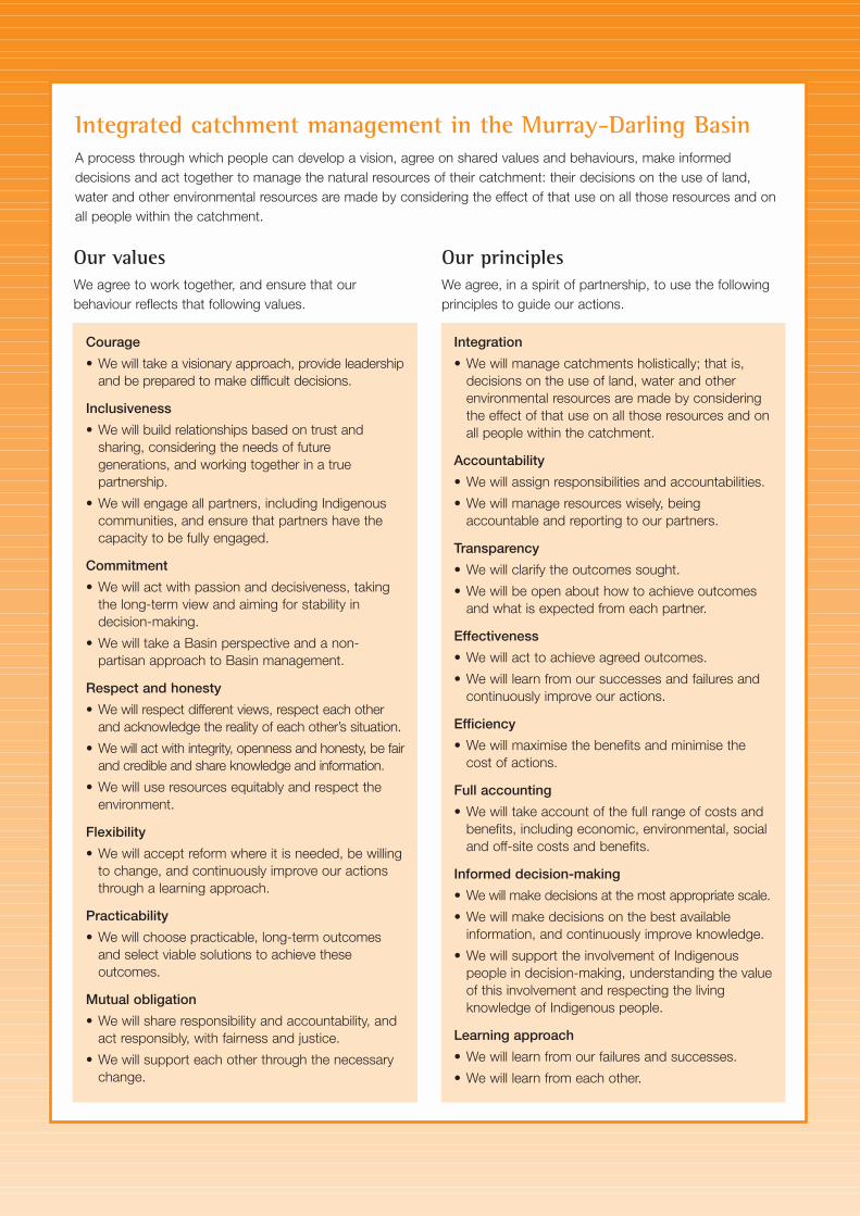
Integrated catchment management in the Murray-Darling BasinA process through which people can develop a vision, agree on shared values and behaviours, make informeddecisions and act together to manage the natural resources of their catchment: their decisions on the use of land,water and other environmental resources are made by considering the effect of that use on all those resources and onall people within the catchment.
Our valuesWe agree to work together, and ensure that our behaviour reflects that following values.
Courage
• We will take a visionary approach, provide leadershipand be prepared to make difficult decisions.
Inclusiveness
• We will build relationships based on trust andsharing, considering the needs of futuregenerations, and working together in a truepartnership.
• We will engage all partners, including Indigenouscommunities, and ensure that partners have thecapacity to be fully engaged.
Commitment
• We will act with passion and decisiveness, takingthe long-term view and aiming for stability indecision-making.
• We will take a Basin perspective and a non-partisan approach to Basin management.
Respect and honesty
• We will respect different views, respect each otherand acknowledge the reality of each other’s situation.
• We will act with integrity, openness and honesty, be fairand credible and share knowledge and information.
• We will use resources equitably and respect theenvironment.
Flexibility
• We will accept reform where it is needed, be willingto change, and continuously improve our actionsthrough a learning approach.
Practicability
• We will choose practicable, long-term outcomesand select viable solutions to achieve theseoutcomes.
Mutual obligation
• We will share responsibility and accountability, andact responsibly, with fairness and justice.
• We will support each other through the necessarychange.
Our principlesWe agree, in a spirit of partnership, to use the followingprinciples to guide our actions.
Integration
• We will manage catchments holistically; that is,decisions on the use of land, water and otherenvironmental resources are made by consideringthe effect of that use on all those resources and onall people within the catchment.
Accountability
• We will assign responsibilities and accountabilities.
• We will manage resources wisely, beingaccountable and reporting to our partners.
Transparency
• We will clarify the outcomes sought.
• We will be open about how to achieve outcomesand what is expected from each partner.
Effectiveness
• We will act to achieve agreed outcomes.
• We will learn from our successes and failures andcontinuously improve our actions.
Efficiency
• We will maximise the benefits and minimise thecost of actions.
Full accounting
• We will take account of the full range of costs andbenefits, including economic, environmental, socialand off-site costs and benefits.
Informed decision-making
• We will make decisions at the most appropriate scale.
• We will make decisions on the best availableinformation, and continuously improve knowledge.
• We will support the involvement of Indigenouspeople in decision-making, understanding the valueof this involvement and respecting the livingknowledge of Indigenous people.
Learning approach
• We will learn from our failures and successes.
• We will learn from each other.
