service description: tactical exchange of intended … · service description: tactical exchange of...
TRANSCRIPT

Lead Author Reviewer Approved for Release
Name: Mads Bentzen Billesø Name: Transnational Project Co-
ordination Group
Name: Project Steering Committee
Job Title: WP6 Contributor Job Title: N/A Job Title: N/A
Partner: DMA Partner: All Partner: All
Signature: pp Alwyn I. Williams Signature: pp Alwyn I. Williams Signature: pp Alwyn I. Williams
Service Description: Tactical Exchange of
Intended Routes
Issue: 1
Issue Status: Approved
Issue Date: 18/05/2015

Service Description: Tactical Exchange of Intended Routes Issue: 1 Approved
ACCSEAS Project Page 2 of 23
Executive Summary Every ship is by regulation forced to do a berth-to-berth route plan before leaving port (ICS, 1998). This intended route resides locked in the navigation system of each ship. By enabling vessels to send and receive each other’s intended routes automatically, and display them on their own ECDIS, a possibility to decrease the risk for dangerous situations appears.
Further, by making it possible for shore-based services to monitor the intended routes of vessels, pilots and VTS operators have improved situation awareness and it may be possible to assist ships unknowingly heading into danger, a situation not quite uncommon.
Previously, the EfficienSea project has developed, explored and tested route exchange functionality with promising results. As part of the ACCSEAS project, it was decided to improve and develop these concepts further. Additional functionality, improved user experience and Maritime Cloud integration has been implemented using the e-Navigation Prototype Display (EPD), and field tests involving ships and shore-side VTS centres together with simulation sessions have been conducted with good results.

Service Description: Tactical Exchange of Intended Routes Issue: 1 Approved
ACCSEAS Project Page 3 of 23
Contents
1 Introduction .................................................................................................................... 5
1.1 Background............................................................................................................. 5
1.2 Earlier Tests............................................................................................................ 5
1.3 Scope ..................................................................................................................... 6
2 Description of Developed Service ................................................................................... 7
2.1 Creating and Modifying Routes ............................................................................... 7
2.2 Route Manager ....................................................................................................... 7
2.3 Active Route ........................................................................................................... 8
2.4 Intended Routes ..................................................................................................... 8
2.4.1 Intended Route Broadcasting ........................................................................... 9
2.4.2 Intended Route Display .................................................................................... 9
2.5 Closest Point of Approach (CPA) .......................................................................... 11
2.5.1 CPA Warnings ............................................................................................... 11
2.5.2 CPA Guidance ............................................................................................... 12
3 Technical Implementation............................................................................................. 13
3.1.1 EPD ............................................................................................................... 13
3.1.2 Maritime Cloud ............................................................................................... 13
3.2 Intended Route Broadcast Model .......................................................................... 14
3.3 Intended Route Broadcast Implementation ........................................................... 14
4 Observations and Feedback ......................................................................................... 16
4.1 Simulations ........................................................................................................... 16
4.1.1 Conceptual level ............................................................................................ 16
4.1.2 Procedural level ............................................................................................. 18
4.1.3 Functional level .............................................................................................. 18
4.1.4 HMI level ........................................................................................................ 18
4.1.5 Survey ........................................................................................................... 21
4.1.6 Discussion ..................................................................................................... 21
4.1.7 Conclusions ................................................................................................... 22
4.2 Live tests/demonstrations Humber ........................................................................ 23

Service Description: Tactical Exchange of Intended Routes Issue: 1 Approved
ACCSEAS Project Page 4 of 23
Document Disclaimer
Document is uncontrolled when removed from iManage (either electronic or printed)
Document Information
Project Title ACCSEAS
Work Package No. 6
Document Title Service Description: Tactical Exchange of Intended Routes
Description This document describes the results of the efforts in developing and testing the Tactical Exchange of Intended Route service.
Date [Publish Date]
Lead Author Mads Bentzen Billesø
Lead Author’s Contact Information
Søfartsstyrelsen / Danish Maritime Authority
Maritime Analysis, Technology and Business Development (MAF), e-Navigation
Telephone: +45 9137 6329
E-mail: [email protected]
Contributing Author(s) WP6 Contributors
iManage Location 29918
Circulation 1. Client
2. Project Files (i-manage)
3. Transnational Project Co-ordination Group
4. Project Steering Committee
NSRP Secretariat Approval
Yes / No

Service Description: Tactical Exchange of Intended Routes Issue: 1 Approved
ACCSEAS Project Page 5 of 23
1 Introduction
1.1 Background
“What is your intention?” is a common question over the VHF when two ships are in doubt of each other’s intentions. Misunderstanding each other’s intentions is not seldom the cause of accidents at sea. Even worse is when ships in doubt do not ask for intentions, but instead make a presumption.
Liu and Wu (2003) studied 100 collision reports from the maritime authorities of the UK, USA, Australia, Canada, New Zealand and Sweden. They found that communication problems were one of the most prominent causes of accidents at sea. The most frequently identified causes were lack of communication and misinterpreting information. Underlying human factor issues, they concluded, were the reluctance of navigators to exchange information.
Every ship is by regulations forced to do a berth-to-berth route plan before leaving port (ICS, 1998). This intended route resides locked in the navigation system of each ship. By enabling vessels to send and receive each other’s intended routes, and display them on their own ECDIS, a possibility to decrease the risk for conflicting situations appears. Further, by making it possible for shore-based services to send routes to vessels, pilots and VTS operators can assist ships unknowingly heading into danger, a situation not quite uncommon.
About 33 000 to 35 000 ships over 300 GT pass every year the Sound between Sweden and Denmark (not counting the many ferries going back and forward across the Sound). In later years there have occurred between 50 and 70 incidents every year where VTS operators have been forced to take action, mostly to warn ships with too deep draughts or heading for shallows (Garbebring, 2011). In this way it is possible to create a unified navigation team by joining the ship’s bridge team and the shore-based VTS team by new technology to share information.
Tactical Exchange of Intended Routes should be seen as a supplement to traditional VHF voice communication which is subject to misunderstandings due to language problems, lacking situation awareness, wrong interpretation of surroundings and human error.
1.2 Earlier Tests
Previously, the EfficienSea and MONALISA projects have developed, explored and tested route exchange functionality using the e-Navigation Prototype Display (EPD). This involved concepts such as:
Intended route exchange: A ships currently active route is broadcast via AIS to other ships and shore centres in range.
Route suggestion service: A shore-based VTS centre may send a suggested route to a vessel via AIS. The vessel can see the suggested route and reject or accept the proposal.
Strategic route exchange: A vessel can send a proposed voyage plan to a nearby shore-based VTS centre. Subsequently, the involved VTS centre and vessel can send amended route proposals back and forth; ‘negotiate’, until both parties have accepted or rejected the voyage plan.

Service Description: Tactical Exchange of Intended Routes Issue: 1 Approved
ACCSEAS Project Page 6 of 23
1.3 Scope
As part of the ACCSEAS project, it was decided to improve and develop these concepts further.
Using AIS as the means of route exchange has substantial advantages. However, in practice it has turned out to be too fragile, due to the limitations in the protocol and poor robustness of delivery. In the ACCSEAS project, all services have been migrated to use the Maritime Cloud Maritime Messaging Service (MMS) as the means of communication – see Annex on Maritme Cloud for further details).
To improve the user experience, the route exchange services, along with other maritime services such as MSI, messaging, and general notifications, have been integrated into a unified Notification Centre with a standardized way for presenting and handling notifications of varying severity (notices, warnings and alerts).
This report will focus on the tactical exchange of intended routes and the functionality and improvements implemented and tested in the ACCSEAS project. In addition to Maritime Cloud integration and Notification Centre integration, this also includes various user experience optimizations and closest point of approach (CPA) guidance.

Service Description: Tactical Exchange of Intended Routes Issue: 1 Approved
ACCSEAS Project Page 7 of 23
2 Description of Developed Service
2.1 Creating and Modifying Routes
Routes are added via the New Route ( ) toolbar button. Consecutive waypoints are inserted by clicking on the chart area, and the route is completed by selecting End Route from the right-click menu.
Existing routes can be modified in situ by dragging waypoints around, or by adding and deleting waypoints from the context sensitive route menu.
Routes can also be edited in detail via the Route Properties dialog. All route data, such as name, waypoint positions, XTD, SOG, etc., can be adjusted. In addition, there are various functions for re-computing speed based on ETA and vice versa.
Figure 1: The Route Properties Dialog
2.2 Route Manager
A full list of routes are available in the Route Manager Dialog, which also provides functions for editing routes, activating and deactivating routes (ship-side only), exporting and importing routes in commonly used formats.
Figure 2: The Route Manager Dialog
Service Description: Tactical Exchange of Intended Routes Issue: 1 Approved
ACCSEAS Project Page 8 of 23
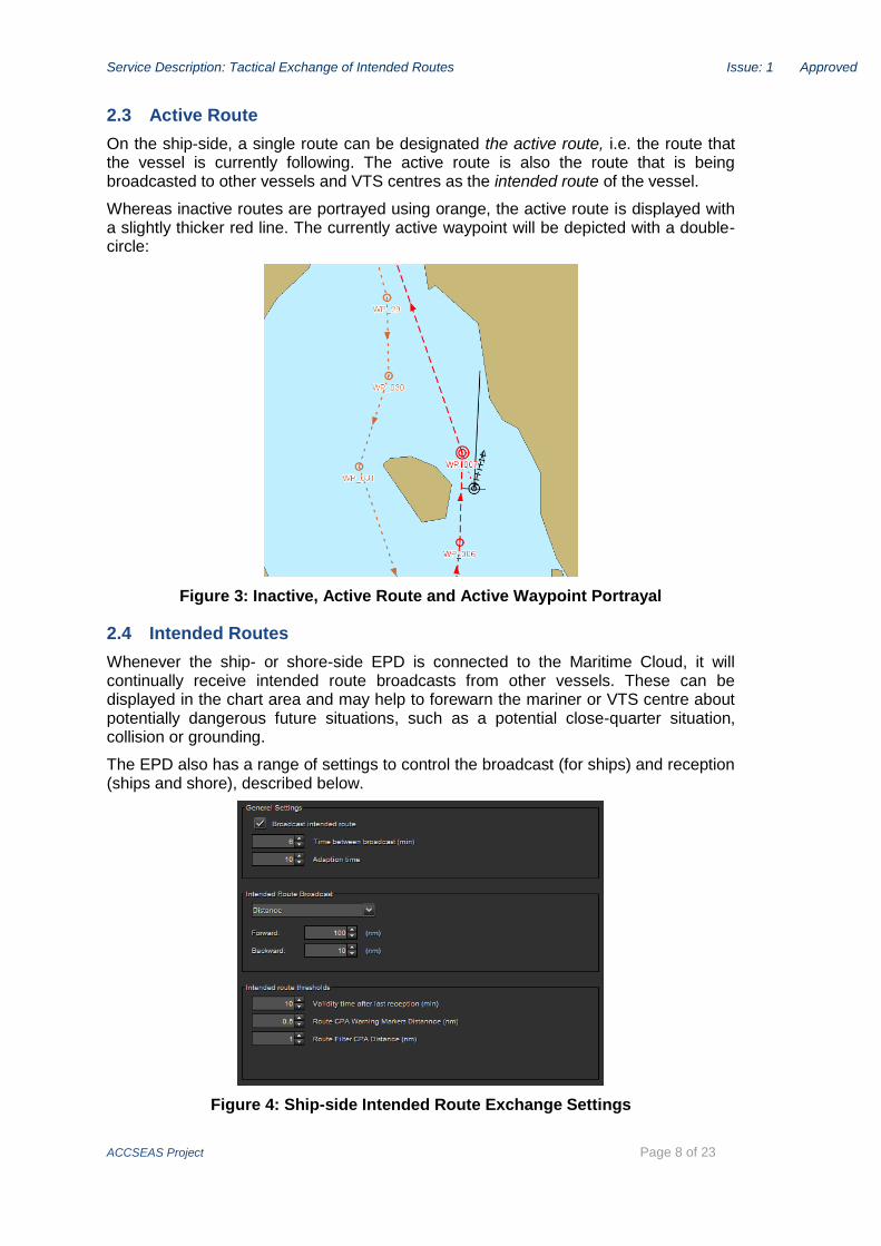
2.3 Active Route
On the ship-side, a single route can be designated the active route, i.e. the route that the vessel is currently following. The active route is also the route that is being broadcasted to other vessels and VTS centres as the intended route of the vessel.
Whereas inactive routes are portrayed using orange, the active route is displayed with a slightly thicker red line. The currently active waypoint will be depicted with a double-circle:
Figure 3: Inactive, Active Route and Active Waypoint Portrayal
2.4 Intended Routes
Whenever the ship- or shore-side EPD is connected to the Maritime Cloud, it will continually receive intended route broadcasts from other vessels. These can be displayed in the chart area and may help to forewarn the mariner or VTS centre about potentially dangerous future situations, such as a potential close-quarter situation, collision or grounding.
The EPD also has a range of settings to control the broadcast (for ships) and reception (ships and shore), described below.
Figure 4: Ship-side Intended Route Exchange Settings

Service Description: Tactical Exchange of Intended Routes Issue: 1 Approved
ACCSEAS Project Page 9 of 23
2.4.1 Intended Route Broadcasting
The intended route is broadcasted using the following rules:
On route change (activate, de-activate, active waypoint change).
Regularly on a user defined interval (default 6 minutes).
Adaptively, when the estimated ETA at the active waypoint differs more than a threshold compared to the last broadcast. Example: If an ETA changes more than 10 minutes from a previous estimated time it forces a broadcast.
Since routes may be quite large (contain many waypoints) and to avoid cluttering the navigational displays with irrelevant information, routes are not broadcast in their entirety. The waypoints to send is based on the following rules:
The number of waypoints included before the active waypoint is determined by either: time, distance or number (but always at least one if it exists)
The number of waypoints included after the active waypoint is determined by either: time, distance or number (but always at least one if it exists)
2.4.2 Intended Route Display
The intended routes are displayed in a separate layer of the EPD, which can be turned on and off. Furthermore, the visibility of the individual intended route can be toggled, and indeed, to avoid clutter on the navigational display, all intended routes are initially hidden. The user can toggle the intended route of all or specific nearby vessels via the vessel target context menu.
By default, the intended routes are depicted in green, using a slightly lighter appearance than the users own routes. The active waypoint is flagged with a double-circle, and past route segments are grey:
Figure 5: Intended Route Portrayal
Between the vessels current position and the active waypoint, a finely dotted line segment is added and dynamically updated whenever the vessel position changes.
If the user hovers the mouse over the route, a tooltip window will be displayed stating the computed ETA at that particular position:

Service Description: Tactical Exchange of Intended Routes Issue: 1 Approved
ACCSEAS Project Page 10 of 23
Figure 6: Intended Route Tooltip Window
If multiple intended routes are displayed in the same area, it can be difficult to distinguish the individual routes. Similarly, a user may want to mark out a specific route of particular interest. To help solve these concerns, the context sensitive intended routes menu allows the user to assign a different colour than green to a route.
Figure 7: Distinguishing intermingled routes by assigning a different colour
Service Description: Tactical Exchange of Intended Routes Issue: 1 Approved
ACCSEAS Project Page 11 of 23
The validity of an intended route depends on when it was last updated via an intended route broadcast - a quality measure that is being reflected in the route portrayal. When a new broadcast is received, the route will be completely opaque, and henceforth it will gradually become more and more transparent until, after a configurable number of minutes, it becomes completely invisible.
2.5 Closest Point of Approach (CPA)
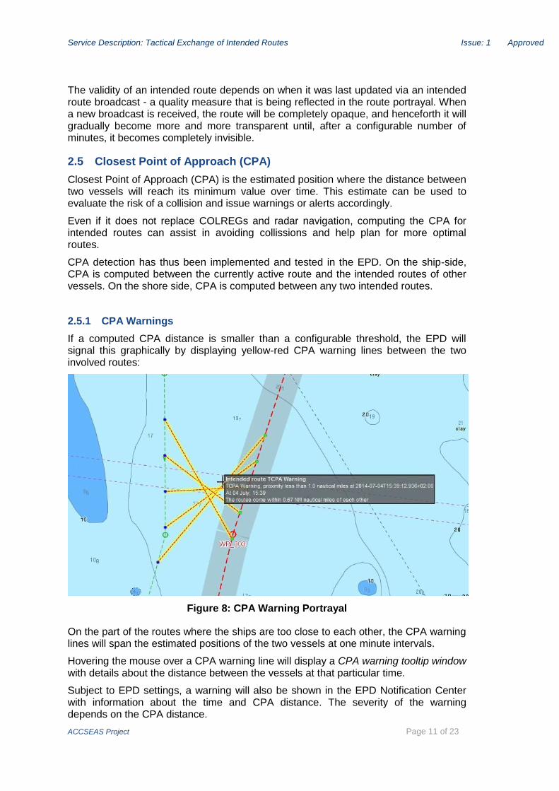
Closest Point of Approach (CPA) is the estimated position where the distance between two vessels will reach its minimum value over time. This estimate can be used to evaluate the risk of a collision and issue warnings or alerts accordingly.
Even if it does not replace COLREGs and radar navigation, computing the CPA for intended routes can assist in avoiding collissions and help plan for more optimal routes.
CPA detection has thus been implemented and tested in the EPD. On the ship-side, CPA is computed between the currently active route and the intended routes of other vessels. On the shore side, CPA is computed between any two intended routes.
2.5.1 CPA Warnings
If a computed CPA distance is smaller than a configurable threshold, the EPD will signal this graphically by displaying yellow-red CPA warning lines between the two involved routes:
Figure 8: CPA Warning Portrayal
On the part of the routes where the ships are too close to each other, the CPA warning lines will span the estimated positions of the two vessels at one minute intervals.
Hovering the mouse over a CPA warning line will display a CPA warning tooltip window with details about the distance between the vessels at that particular time.
Subject to EPD settings, a warning will also be shown in the EPD Notification Center with information about the time and CPA distance. The severity of the warning depends on the CPA distance.

Service Description: Tactical Exchange of Intended Routes Issue: 1 Approved
ACCSEAS Project Page 12 of 23
Figure 9: CPA Alert in the EPD Notification Centre
For a more elaborate example of CPA warnings in the EPD, and the type of action a navigator should take to mitigate the situation, please refer to the video at:
https://s3.amazonaws.com/dma-static-assets/2014-07-04-1501-55.flv
2.5.2 CPA Guidance
As described in the Observations and Feedback section, the CPA Warning functionality was not always as useful as One might have hoped for.
An alternative and simpler approach, CPA Guidance, was implemented in the ship-side EPD. Whenever the mouse is hovered over an intended route, a green-red CPA guidance line is displayed between the intended route at the given position and the estimated position of the own-ship at the same time (i.e. on the active route). A tooltip window will display the vessel name, time and distance.
Figure 10: CPA Guidance Line and Tooltip Window

Service Description: Tactical Exchange of Intended Routes Issue: 1 Approved
ACCSEAS Project Page 13 of 23
3 Technical Implementation
This chapter outlines the technical implementation of the intended route exchange service, focusing specifically on the intended route broadcasting functionality.
The EPD client (ship and shore) and the Maritime Cloud have been used in the reference implementation of the intended route exchange. Furthermore, the system has served as a test bench for the user tests.
3.1.1 EPD
The e-Navigation Prototype Display (EPD) comes in two flavours, EPDShip and EPDShore, used for testing ECDIS-like functionality on a vessel, respectively on a VTS centre.
The EPD client is open source, and the project is available on GitHub: https://github.com/dma-enav/EPD
3.1.2 Maritime Cloud
The Maritime Cloud is a digital Information Technology framework consisting of standards, infrastructure and governance that facilitates secure interoperable information exchange between stakeholders in the maritime community using the principles of Service Oriented Architectures (SOA). For a detailed description of the Maritime Cloud, which is also open source, please refer to http://maritimecloud.net.
EPD uses the Maritime Cloud Messaging Service (MMS) for services such as intended route exchange, route suggestions, MSI-NM and text messaging. A vessel will broadcast its intended route periodically via MMS, and all interested parties (i.e. vessels, VTS centres, etc.) will hook up as listeners for this message type and receive the intended route broadcasts.
Figure 11: Broadcasting via the Maritime Cloud

Service Description: Tactical Exchange of Intended Routes Issue: 1 Approved
ACCSEAS Project Page 14 of 23
3.2 Intended Route Broadcast Model
The UML model for an intended route broadcast is given below:
Figure 12: Intended Route UML Model
3.3 Intended Route Broadcast Implementation
The intended route broadcast model has been implemented in the Maritime Cloud Description Language (MSDL) format. The MSDL files are maintained at:
https://github.com/MaritimeCloud/Services/tree/master/mc-services/src/main/msdl/dma/route
- The files are reproduced in Appendix A.
As mentioned in a previous chapter, the intended route is broadcast using the following rules:
On route change (activate, de-activate, active waypoint change).
Regularly on a user defined interval (default 6 minutes).
Adaptively, when the estimated ETA at the active waypoint differs more than a threshold compared to the last broadcast.
Since routes may be quite large (contain many waypoints) and to avoid cluttering the navigational displays with irrelevant information, routes are not broadcast in their entirety. The waypoints to send is based on the following rules:

Service Description: Tactical Exchange of Intended Routes Issue: 1 Approved
ACCSEAS Project Page 15 of 23
The number of waypoints included before the active waypoint is determined by either: time, distance or number (but always at least one if it exists)
The number of waypoints included after the active waypoint is determined by either: time, distance or number (but always at least one if it exists)

Service Description: Tactical Exchange of Intended Routes Issue: 1 Approved
ACCSEAS Project Page 16 of 23
4 Observations and Feedback
4.1 Simulations
The No-Go area service was tested during the 29 September to 3 October simulator session at Chalmers University in Gothenburg together with the Intended and Suggested route services. The method used was Usability test. Usability is “the extent to which a product can be used by specified users to achieve specified goals with effectiveness, efficiency and satisfaction in a specified context of use” (ISO 9241-11) No efficiency or effectiveness measures were used but qualitative data collected. Special focus was on usability, professional acceptance and unintended consequences of change.
Results are summarized below. References are made to the video data (video number; time code). The results are divided into four levels: conceptual, procedural, functional and HMI level. Then there is a brief discussion with the same structure and a conclusion.
4.1.1 Conceptual level
All the participants agreed that this service is valuable. “I might not have said so three days ago, but now having used it: Yes, the concept is very good. Provided the data that is displayed is correct.” (Humber pilot, 12 years’ experience) (00168; 01.51) On a question if someone in the group was against the concept, there were head shakes and silence. (00168; 02.12) Several of the participants soon got used to the service where they could see ships intentions; one said “after having used the system for six hours I find it annoying not being able to see ships intentions.” (00168; 04.24)
Training
Several participants talked about the importance of “correct data”: that the voyage plan was updated and correct and from birth to berth. It is necessary that the bridge personal are trained and can handle the system. Generally today, the Humber participants explained, the tankers coming into river have very good passage plans because they are heavily vetted. The general cargo and bulk carries generally tends to have a voyage plan that either stops at the pilot station, or – if it goes all the way to the birth – did so by a couple of haphazard waypoints. If the displayed data is not correct it could be a very dangerous concept: you think you know where someone is going, but instead they are going a completely different route. E.g. there might be a change in the voyage plan but because the 2nd officer responsible for voyage planning is not on watch, the new intentions are not displayed. (00168; 03.30)
One of the pilots said: On a big ship like the P&O Pride of Hull they have the time and people to do the voyage plan prudently with the right speed on all legs, etc. But on a small coaster they will just click out the waypoints, they don’t have the time or the people to do anything else. (3575; 12:03)
A representative from the port authority said that you can take the AIS messages as an example. They are not always updated, and that is a very simple procedure. (00168; 03.55) It is great giving people high quality tools but it is no use doing that if they do not know how to use the system correctly. Otherwise it might be dangerous. (00168; 05.04) “So my concern is not so much the quality of the proposed system, much more so, the quality of the people onboard that must be able to use the system.” (00168; 05.52).

Service Description: Tactical Exchange of Intended Routes Issue: 1 Approved
ACCSEAS Project Page 17 of 23
Cluttering
Going into details, the participants felt that it is important that rather than displaying all ships Intended routes all the time (which would clutter the display) you could “interrogate” the display for intentions of vessels of interest. (00168; 13.07)
Turning off transmission intended routes
A discussion took place of what to do if a ship for some reason had to deviate from its route. One suggestion from the developers is that there should be an easy (or maybe even automatic) way of turning off the transmission of the Intended route if the vessel for some reason deviated too far from its intended voyage plan. One of the pilots answered “Yes, having no data is better than having the wrong data.” (00168; 04.16) There was an agreement that it could be a good thing if the system stopped sending route intentions if the ship was some predefined distance from its intended route for a predefined amount of time. (00168; 07.25) But for minor deviations from the intended route, like over taking, or giving extra space in a meeting situation, no one in the group felt it was necessary to stop sending, or changing the intended route. It would be obvious why the deviation was made. There was also an agreement that the Intended route service should not be used as a collision avoidance tool in close quarters situations. (00168; 12.00)
Use in approaches and open sea
It was felt that the Intended route service was probably being more important in open seas than in port approaches like the Humber River, because there is already a risk mitigation service like pilot onboard and VTS that keeps an eye on things. But for ships coming to the pilot station it is good, but there are also uses on the river. (00168; 08.31) Approaches to junction points is an example where the Intended route service can be very valuable, for example a small ship leaving the Baltic Sea destined for Rotterdam may equally well take a route via The Sound, the Great Belt or the Kiel Canal. Being able to see the intended route makes it possible for an overtaking ship to place itself on the proper side of the other ship. (00168; 10.11)
Trust
One of the participants said on a question that he would trust the Intended route in the same way that he today trust the AIS information. “I will not trust 100 percent, but it is helpful.” (00168; 10.59)
Planned speed vs. current speed
There was a major discussion on whether planned speed or current speed should be used when calculating a ships future position. The Intended route service as it was implemented in the prototype system was using the planned ETA in all waypoints to calculate where own and other ships would be at a certain time. The planned speed was based on the notion that ships should be at their final destination precisely in the planned arrival time. However, one of the pilots commented that in reality ships will not be following their planned speed exactly why the ETAs in different waypoints (at least the closest ones) instead should reflect the actual, current, speed of a vessel. (00170; 05.39) “You always want to go a little bit faster to make sure that you can make your ETS. Rush to wait. You will burn a little bit more fuel, but it cost more to let the stevedores, the lorries etcetera wait.” (00170; 08.19)
Pre-checked Alternative routes
An interesting issue brought up was use of alternative routes. When you are doing you birth-to-birth voyage plan you can make e.g. two alternative routes on either side of e.g. an island or a bank. (00191; 09.52) Both of them will be checked for UKC etc. One

Service Description: Tactical Exchange of Intended Routes Issue: 1 Approved
ACCSEAS Project Page 18 of 23
of them would be the preferred one (visible as the Intended route) but the officer could easily change to the alternative route if the weather or traffic situation so demanded.
4.1.2 Procedural level
Workload
It was discussed if the Intended route service would increase workload compared with today to a point where you would need to have an extra person on bridge just to run the system. Observation during the test scenarios showed that the usability of the system was not optimal yet and the participants go help when they did not know how to activate a feature. Several participants commented however that they would expect the handling of the service to be smooth once they mastered the system. The test scenarios took place close to port or in the approach and this is where you would normally be two persons on the bridge. In a deep sea passage there would be only one officer on the bridge, but then the situations would normally be a lot calmer. (00168; 14.26). The workload remains the same, but the system will increase the quality of decision making. (00168; 14.55)
The Intended route service might lessen workload for the pilot as the rest of the bridge team can see the intentions and future whereabouts of other vessels. One of the pilots mentioned that he spent a lot of time explaining to the captain or watch officer what was the intentions of other ships in the area leaving berth or entering into the approach channel. (00168; 09.07)
One of the VTS operator said that given the VTS had Traffic Organization Service (TOS) authority the Intended route service would greatly increase the opportunity and possibility to organize the traffic. This would be of great value but would also increase the workload in the VTS.
4.1.3 Functional level
Normally you have your ECDIS off-centred with most of the space in front of your ship and very little space behind you. But sometimes you are overtaken by a much faster ship. If you use CPA as a filter you might get too many intended routes visible cluttering the screen, but it would be nice if you could have a “guard zone” astern which would turn on Intended routes only from overtaking ships. (00170; 13.52) It would probably be necessary to have a “harbour” and a “sea” mode with different CPA filter settings. (00170; 14.23)
An issue could be that you are making an approach. You investigate the other vessels intended routes and you make a strategy for how you want to deal with upcoming meetings. Then one of the vessels changes his intended route. The chance is that you will not notice that. It might be useful with some form of highlighting of changed intentions? Or will it make the whole display too complex and messy? (00192; 19.43)
4.1.4 HMI level
Intuitive use
The user friendliness of the system was discussed. It was pointed out that it was important that all watch officers could use the system so that updates of Intended routes did not have to wait for that the responsible officer was on watch. (00168; 03.30) “But I think if we were here for another week we would be a lot quicker and comfortable with it. It is not a difficult system to use” (00168; 13.37). It is more a question of familiarity, rather than the system being complicated. ((00168; 13.58)
Cluttering
During the first round of tests users commented on the HMI that it was difficult to distinguish intended routes from each other as they all had the same light green colour,

Service Description: Tactical Exchange of Intended Routes Issue: 1 Approved
ACCSEAS Project Page 19 of 23
and also to know which track belonged to which ship (the label with ship information was only shown on mouse-over on the vessel target triangle). Because we had the programmer present during the tests the interface was updated for the next set of trials starting the day after. In the new HMI an Intended track could be queried by pointing at it with the cursor. The track would then become highlighted in a darker green colour, the vessels icon would become highlighted with a circle and the position on the intended track line where the cursor pointed would be connected to the own ship’s position at the same time by a bearing line.
Figure 13: By pointing with the cursor at an Intended route of another ship the route would become highlighted in a darker green colour and the present
position of the vessel which the route belonged to also becomes highlighted with a circle. The position on the track which the cursor is pointing at is
connected with the own ship’s position at the same time.
These bearing lines could be used to query another ships track about the closest point of approach (CPA). The second round of participants found theses new features useful and decluttered the interface somewhat.
Overtaking another vessel on a similar route is still difficult because the intended route of the other vessel is hidden by your own track (00168; 19.50)
It was also mentioned that routes needed to be transparent so that they did not hide e.g. depth figures. (00192; 03.56)
“The green colour of the intended routes makes them difficult to see; especially if you got more than one. Maybe you could use different colours; you need to be able to separate one vessel from another.” (3563; 11:39)
The text and symbols are too small in the EPD. “When you get to our age you cannot see such small print” (3568; 11:49)

Service Description: Tactical Exchange of Intended Routes Issue: 1 Approved
ACCSEAS Project Page 20 of 23
Figure 14: The top screen dump shows the Intended route in the original weak green colour, the bottom image shows the improved version with the queried
route highlighted in darker green.
Figure 15: A screen shot from the updated HMI with the Intended route
highlighted in darker green. The ship’s present position is also highlighted with a circle and the bearing line connecting own ships position when the queried
ship is at the position of the cursor.

Service Description: Tactical Exchange of Intended Routes Issue: 1 Approved
ACCSEAS Project Page 21 of 23
4.1.5 Survey
The participants were asked to summarise their impressions about the service in a survey with three questions:
1. What is your opinion about the tested Intended routes concept? All the 9 answering participants answered Good or Very good. No-one answered I don’t know or Bad or Very Bad.
2. Do you think a similar Intended routes concept will become reality in the future? On this question all 9 participants answered Probably or Most probably. No one answered I don’t know or Probably or Most probably not.
3. What is your professional opinion about the system tested? On this question the participants were asked to rank their acceptance on a scale between 0 and 5 where 0 was “Totally unacceptable”, 1 was “Not very acceptable”, 2 was “Neither for, nor against”, 3 was “Acceptable”, 4 was “Very acceptable” and 5 was “Extremely acceptable”. The mean acceptance score from the 9 answering participants was 3.7, somewhere between “Acceptable” and “Very acceptable”.
4.1.6 Discussion
It is of course of outmost importance that “intended routes” are understood just as “intentions” and not was necessarily as a deterministic future. This was discussed very much during the 4 day test, but the concept of intended routes (as indicated by the very name of the service) seemed to be fully understood by the participants. There was an agreement that there should be a function that allowed ships to stop sending Intended routes if they for some reason had to change their intentions and did not have time to change the voyage plan on the chart display, but for minor offsets, like overtaking another vessel, or giving extra room in a close quarter situation, they did not feel it was necessary to turn off the Intended route. What was going on would be obvious to everyone.
The scenarios chosen were normal everyday situations and they were based on real scenarios that were either described to us by the Humber pilots and VTS operators on a previous focus group meeting held in Hull several months before. In one case (The number 4 scenario, contravention in the TSS) the scenario was based on a AIS video provided by the Spurn Head VTS. In no case did we see what we considered any dangerous behaviour by the participant onboard or ashore.
Planned versus current speed
The discussion on planned versus current speed was interesting. One major idea with route exchange is to make a new energy and emission saving paradigm with slow steaming and just-in-time-arrival replace the old wasteful full-speed-ahead, then anchor and wait paradigm. To make such a system work ships would be expected to follow their planned voyage plan exactly. This would be necessary to calculate safety feature with dynamic separation where no two ships would be allowed to set out on a voyage plan where they would be at the same place at the same time. So both from a fuel and emission saving, as well as a safety perspective, it would be essential that current and planned speed was the same. This is not the case today, where the present paradigm is “rush to wait”, as was mentioned by one of the participants. Keeping a very exact speed down to a tenth of a knot, according to the voyage plan, would be difficult manually and would require a speed pilot. (Like an autopilot automatically keeps the course, a speed pilot automatically keeps a set speed.) The advanced speed pilots needed are today only used by some ferry lines, and are not common in the merchant fleet. A ships speed is also depending on being within a limited window of propeller revolutions and the speed resulting from the number of revolutions will depend on wind, sea state and depth. So while waiting for engines and

Service Description: Tactical Exchange of Intended Routes Issue: 1 Approved
ACCSEAS Project Page 22 of 23
speed pilots that will allow an exact voyage plan to kept, the use of current speed to calculate ETA in all waypoints except those designated as “critical” (e.g. final destination, arrival at a lock or passing a congested area where traffic management is essential) might be a solution.
Alternative routes
The alternative route suggestions brought up during the test is maybe more relevant to the strategic rote planning of the MONALISA project than the tactical Intended route of the ACCSEAS, but never the less very interesting. If the Ship Traffic Coordination Centre suggested in MONALISA would be aware of both the preferred and the alternative routes, they could, if need be, use the Alternative as a new strategic route suggestion. That way the shipping companies would retain more control of the suggestions made by the STCC (which was mentioned as imperative by a cruise ship captain during another simulation in 2013).
Workload
It was unclear whether the Intended route service would increase or lessen the workload on the bridge. In the scenarios tested the situation was port approach with two officers on the bridge. At times one of them would be occupied handling the chart system. To a large extent this could be because they were not proficient with the system (and several also said that the system felt easy to learn given ample time to practice). The system lends itself to making intentions clear and long ahead negotiating meting and overtaking situations, but because the time needed to change positions of waypoints the system must not be used for collision avoidance in close quarters situations. However, using current instead of planned speed would improve the reliability of the system if a new throttle setting immediately was reflected in the system.
The user interface seemed to be intuitive and relatively easy to work with: OOW added a new WP and dragged it to starboard to indicate for stand-on vessel from starboard that he had the intention to go astern of him. First time user, 50 sec. (3565: 11:44)
4.1.7 Conclusions
Was considered a valuable concept.
Intended routes should be displayed on a need to know basis. Customable. Not to clutter the screen.
The green, dashed representation was considered OK if the route of a particular vessel was highlighted on rollover to make its track more salient. The tracks should also be transparent not to hide important information.
Use current speed to calculate the next 8 waypoints used for the intended route service (unless one of the waypoints is the final destination or otherwise designated as “critical”, e.g. arrival at a lock).
Remember:
CPA Warnings vs. CPA Guidance
Filtering and display of intended routes (always on vs always off)
Toggling specific routes on / off.

Service Description: Tactical Exchange of Intended Routes Issue: 1 Approved
ACCSEAS Project Page 23 of 23
4.2 Live tests/demonstrations Humber
The primary goal of the live tests was to demonstrate the services and solutions working in real life. Feedback on services and usability from the participants in the live tests in Humber was the same as for the participants in the simulations and as described above.
During the demonstrations with Pride of Hull and Humber VTS the Tactical Exchange of Intended Routes service was used via the Maritime Cloud. Routes were shared between ship and VTS via the Maritime Cloud without any problems. Even on a very slow connection (see below).
Figure 16: The general throughput of the internet connection used during the demonstrations was tested. Note the download/upload, response time and that
the service gets a poor grade. The download speed is decent, but shared across the entire ship. The upload speed is ~10 times slower.