sequence stratigraphy of the muddy sandstone and...
TRANSCRIPT

SEQUENCE STRATIGRAPHY OF THE DAKOTA GROUP ANDEQUIVALENTS FROM NORTH-CENTRAL COLORADO TO
NORTHEASTERN NEW MEXICO: DOWN-DIP VARIATIONS INSEQUENCE ANATOMY: A FIELD TRIP GUIDE FOR THE 1996 GSA
ANNUAL MEETING
Sponsored by: Sedimentary Geology Division, Geological Society of America
John Holbrook, Southeast Missouri State University, Cape Girardeau, MO andFrank G. Ethridge, Colorado State University, Ft. Collins, CO
ger-
l
to
k
a
in
the
FIELD TRIP OVERVIEWAND OBJECTIVES
This field trip is designed as a three-dayexcursion to examine Lower Cretaceous, DakotaGroup rocks along the northern Colorado Front Ranand to compare and contrast these rocks with similaage rocks along the northern Colorado Front Rangeand northeastern New Mexico (Fig. 1). An additionacaveat of this trip will be an examination of theCapulin Mountain basaltic cinder cone and a reviewTertiary-Holocene volcanism in the high plains ofnortheastern New Mexico. The first day of theexcursion will consist of stops in the Fort Collins,Loveland and Lyons area of north-central Colorado examine the entire Lower Cretaceous section. AtHorsetooth Reservoir, west of Fort Collins ouremphasis will be on the recognition of surfaces,sequences and systems tracts, and a discussion ofdepositional environments in the Plainview andMuddy sandstones and the intervening Skull CreekShale. At Carter Lake, west of
Loveland Colorado, we will examine the nature of thelower contact of the Dakota Group and discussdepositional environments and lateral and verticalvariation in the Lower Cretaceous, Lytle Formation. On Highway 36, south and east of Lyons, CO we willcontrast the upper portion of the Dakota Group,including the Muddy Sandstone and upper Skull CreeShale with exposures seen earlier along HorsetoothReservoir. Day one will end with a drive south toPueblo, CO. On day two we will examine lithofaciesarchitecture and sequence boundary relationshipswithin the Muddy valley-fill succession near Pueblo,CO, the Capulin Mountain, basaltic cinder cone, andwell-preserved dinosaur trackway at Clayton Lake,northeast New Mexico. Day two will end in Clayton,NM. Day three will involve an examination of down-dip, Muddy-equivalent sandstones at three locationsthe Dry Cimarron Valley, northeast New Mexico. These exposures will afford an opportunity to contrassequence boundary morphology and architecture in tdown-dip area with that observed at locations alongthe northern Colorado Front Range on day one. Thefield trip will end in Denver Colorado.
2
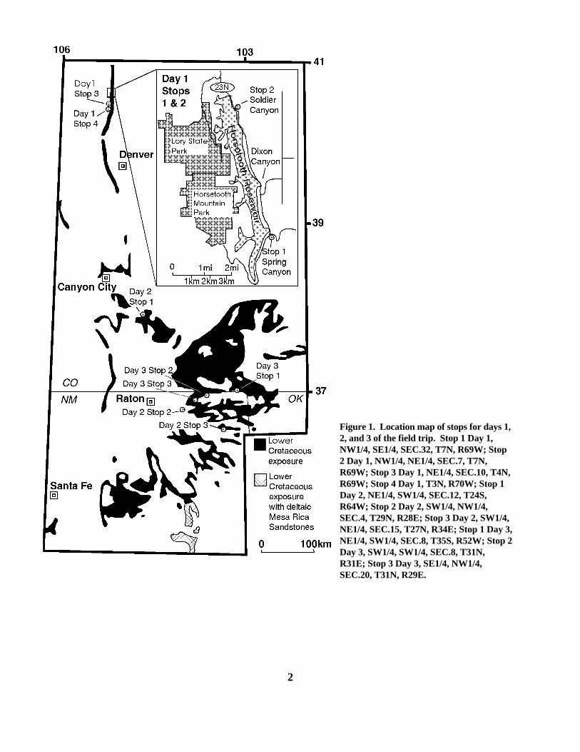
Figure 1. Location map of stops for days 1,2, and 3 of the field trip. Stop 1 Day 1,NW1/4, SE1/4, SEC.32, T7N, R69W; Stop2 Day 1, NW1/4, NE1/4, SEC.7, T7N,R69W; Stop 3 Day 1, NE1/4, SEC.10, T4N,R69W; Stop 4 Day 1, T3N, R70W; Stop 1Day 2, NE1/4, SW1/4, SEC.12, T24S,R64W; Stop 2 Day 2, SW1/4, NW1/4,SEC.4, T29N, R28E; Stop 3 Day 2, SW1/4,NE1/4, SEC.15, T27N, R34E; Stop 1 Day 3,NE1/4, SW1/4, SEC.8, T35S, R52W; Stop 2Day 3, SW1/4, SW1/4, SEC.8, T31N,R31E; Stop 3 Day 3, SE1/4, NW1/4,SEC.20, T31N, R29E.

DAY I - LOWER CRETACEOUS, NORTHERN COLORADO FRONT RANGE
Frank G. Ethridge and John P. Graham, Colorado State University, Fort Collins, CO
s,
e
y
s
y
oals
rnds,
Ah
in
nter
eres&f
r
Rock outcrops along the eastern side of HorsetoothLake, west of Fort Collins, CO, Carter Lake, west ofLoveland, CO and along Highway 36, southeast ofLyons, CO provide excellent two-dimensional viewsof sequences and related unconformities in LowerCretaceous rocks of the Dakota Group (Fig. 2). During day one of this field excursion our efforts willbe concentrated on the sedimentologic characteristicinferred depositional environments and sequencestratigraphic relations, and hydrocarbon trapping inthese Lower Cretaceous rocks. Well developedvalley networks are preserved in several of theselithostratigraphic units which are bounded byunconformities. These unconformities includelowstand surfaces of erosion (LSE) and transgressivsurfaces of erosion (TSE). Most of these surfacescontribute to hydrocarbon trapping with the DenverBasin and also in foreland basins to the north inWyoming and Montana (Dolson and Weimer, 1992;Dolson, et al, 1994).
The Rocky Mountain Foreland, in which we arelocated, has a complex Phanerozoic history driven bregional plate motions. In the simplest terms thishistory can be divided into four phases (Gries et al,1992).
�� Pre-Jurassic passive margin, disturbed by abrief orogenic event that produced theAncestral Rocky Mountains during thePennsylvanian.
�� Development of the Cretaceous InteriorSeaway (foreland basin) during the Sevierorogenic event (mid Jurassic to lateCretaceous) resulting from subduction alongthe western margin of the North Americancraton.
�� Breakup and development of separate basinand ranges during the late Cretaceous toEocene Laramide orogeny, resulting from aperiod of flat-plate subduction.
�� Epirogenic uplift and erosion in late Tertiaryto Quaternary producing the basic topographthat we see today.
3
The bulk of the hydrocarbon production comes fromCretaceous rocks because of the thick shales and cof this period that have generated large reserves(Grieves et al, 1992) during the third of the fourphases mentioned above.
Stop 1 — Spring Canyon Dam Section, HorsetoothReservoir
The Spring Canyon Dam Section (Sec. 32,T7N, R 69W) has been a reference section for theLower Cretaceous stratigraphy in the northern FrontRange Foothills since the initial work of MacKenzie(1963 and 1971). At this stop we will review LoweCretaceous stratigraphy and regional correlations adiscuss formations, members, lithofacies, ichnofaciedepositional environments, and key surfaces andsequences. The vertical sequences of textures,structures, and trace fossils are shown in Figure 3. key to symbols used in stratigraphic columns for eacstop is given in Figure 4.
Three major unconformities are recognized Lower Cretaceous sediments; the K-0, K-1, and K-2(Fig. 2; NOTE: these surfaces are roughly equivaleto the SB-1, SB-2, and SB-3 surfaces discussed latin this guide by Holbrook). These unconformitysurfaces are traced westward by McGookey (1972)and Weimer (1984), and north into Wyoming andMontana by Dolson et al (1991), Dolson and Weimer(1992), and Weimer (1992). Uncertainty existsregarding the dating of these unconformities and othsurfaces from radiometric age dates and faunal zon(Obradovich and Cobban, 1975; Obradovich, 1991 1992a & b). Obradovich (1992b) suggests a date o98.5 to 99 Ma for the Albian/Cenomanian boundary,which is normally placed at the top of the Mowry. Weimer (1992; his figure 6) uses a date of 96 Ma fothis surface and a date of 99 Ma for the middleThermopolis (Skull Creek) Shale. Obradovichsuggests a date of 111 Ma for the Aptian/Albian

4
Figure 2. Generalized stratigraphic column showing stages, formations, and major unconformities in thenorthern Denver basin for rocks ranging in age from Precambrian to Upper Cretaceous. (NOTE: Not allUpper Cretaceous rock units are shown; foreland basin phase includes Upper Jurassic to Paleocene deposits;ultimate BBOE in Rocky Mountain Region from Gries et al, 1992). Column modified from Dolson and Weimer(1992).
th
oce
d
ed
.
g
upe
e
is
te
&
d
n
h
e
t
n
to
a
in
boundary. Scott, et al (1994), using marine andnonmarine palynomorphs from a continuous core inwestern Kansas, near the Colorado border, and thegraphic correlation method, date the threeunconformities at 103, 98 and 94 Ma respectively. Correlation of theses surfaces in western Kansas wiFront Range outcrops is, however, tenuous at best. Within the Dakota Group, along the northern ColoradFront Range, two sequences and one partial sequenare recognized (Fig. 5). Figure five also showslateral relationships of units within the Dakota Groupalong the Colorado Front Range uplift from north ofFort Collins to Turkey Creek, west of Denver. Basicbiostratigraphic data used by Dolson et al (1991) anWeimer (1992) for their interpretations andcorrelations of Lower Cretaceous strata are presentby Eicher (1960, 1962, and 1965). Criteria forrecognition of unconformities in siliciclastic strata arereviewed by Weimer (1992) and Dolson et al (1994)
The Dakota Group section exposed at SprinCanyon Dam begins with the K-0 unconformity at theLytle-Morrison boundary (Fig. 3). This unconformitymarks the lowstand surface of erosion (LSE) at thebase of sequence one (Figs. 3 & 5). The Lytle iscomposed of coarse grained, conglomeraticsandstones, with chert and clay clasts, which grade into medium- to fine-grained sandstones in the middland upper portions. Siltstone to mudstone units arepresent near the middle and at the top of this unit. Thfine-grained units of the Lytle have oxidized red andgreen colors and lack carbonaceous material andhydrocarbon source beds. Sedimentary structuresinclude trough and planar cross bedding, horizontalbeds, and ripples. Scour and fill structures are alsopresent. The fine-grained unit at the top of the Lytle interpreted to be a paleosol based on the lack ofsedimentary structures, the mottled appearance, andthe presence of root casts. The bulk of the Lytle wasprobably deposited by a low-sinuosity fluvial systemthat flowed within an incised valley. At HorsetoothReservoir and at the Bellvue Dome section north ofFort Collins, the Lytle Formation was interpreted asdeposits of both a Donjek-type and a SouthSaskatchewan-type braided stream (Wescot,1979;Dolson, 1985). The uppermost portion of the Lytle aBellvue Dome was interpreted as point bar, crevasssplay and well drained swamp deposits (Dolson,1985). The K-1 unconformity at the top of the Lytlemarks the LSE at the base of sequence two (Figs. 3 5).
The Plainview is composed of thinly bedded,
5
medium- to very fine-grained sandstones interbeddewith shale or siltstone laminae (Fig. 3). It containswave ripples, horizontal laminations, herringbonecross-stratification, and flame structures. Bioturbatioincludes root structures, and Rhizocorallium jenese,Planolites montanus, and Arenicolites sp. burrows. In general this ichnofacies is characterized by a lowdiversity and a high density of burrows. All of thesefeatures suggest a general coastal plain/shorefaceinterpretation for the depositional environment. Nortof Fort Collins, at the Bellvue Dome section, thePlainview has a somewhat different verticalsuccession of lithofacies, which are interpreted asdeposits of a transgressive barrier island (Dolson,1985). Wescott (1979) interpreted the PlainviewFormation along Horsetooth Reservoir as a subtidal,mixed sand and mud flat deposit. To the south, in tharea west of Denver, the Plainview is interpreted astidal flat and small channel deposits ( Weimer, et al,1990).
The basal portion of the overlying SkullCreek Shale is covered; however, it is clear fromwork by Dolson (1981 & 1985) to the north andWeimer (summarized in his 1992 overview paper)that the top of the Plainveiw along the Colorado FronRange uplift is a transgressive surface of erosion(TSE) with a sudden deepening from coastalplain/foreshore deposits to offshore claystones andshales of the lower portion of the Skull Creek. At thebase of the exposed Skull Creek outcrop, the sectioconsists of dark-grey marine shales, which containbentonite beds and several thin, discontinuousbioclastic limestones. The shales are essentiallyunborrowed and this section is interpreted as acondensed section (CS). Samples from the shalesfrom this part of the section have the highest totalorganic carbon (TOC) values observed in the SkullCreek. Previous interpretations of the Skull CreekShale to Fort Collins Member interval suggested agradational succession of facies from neritic shale middle delta front sandstone (Weimer et al, 1990;Dolson and Weimer, 1992). However, the presenceof gutter casts at the base of a hummocky to swaleycross-stratified lower shoreface succession suggestspreviously unrecognized progradational event thatresulted from a relative sea-level fall (i.e., a forcedregression; Posamentier et al, 1992; Graham andEthridge, 1995). Similar sharp-based, shorefacesequences have been documented from UpperCretaceous shelf clastics in the Alberta foreland bas(Plint, 1991; Walker and Plint, 1992).

6
Figure 3. Detailed stratigraphic column at Spring Canyon Dam section, southeast side of Horsetooth Reservoir,Larimer County, Colorado, showing thickness, trace fossils, sedimentary structures, and grain size variationwithin the Lower Cretaceous Dakota Group. See Figure 4 for key to symbols (from Ethridge, et al, 1994b andGraham and Ethridge, 1995).

7
Figure 4. Key to symbols used in stratigraphic columns for day one of this field guide (from Ethridge, et al,1994b and Graham and Ethridge, 1995).

8
Figure 5. Restored stratigraphic section of Dakota Group (Albian) along the Front Range uplift from Colorado-Wyoming state line to south of Morrison, Colorado. Section was compiled from outcrop sections and nearbysubsurface control. Modified from MacKenzie (1971), Weimer (1984), and Weimer et al (1990). FromWeimer (1992).

ain
d,
rt
ta.
d
ted
f
it
nto
e
d
e7,
Above the forced regression in the SkullCreek, thin interbedded sandstones and shales conta low diversity and low density ichnofaciescomprised of small U-shaped Arenicolites sparsusand small, grain-lined Palaeophycus herbertiburrows. These are followed upward by a normalshoaling-upward succession of deposits characterizein general, by a high diversity and a high density of burrows. The lower portion of this successioncontains mostly Asterosoma zoned, Anconichnushorizontalis, Schaubcylindrichus coronus, verticalcomposite tubes, Planolites beverlyensis, andTeichichnus rectus. The upper sandstones areburrowed, mostly by Asterosoma zoned,Ophiomorpha irregularis, and vertical compositetubes. The succession from middle Skull Creek to FoCollins Member of the Muddy Sandstone (Fig. 3) ischaracterized by an increase in the degree ofbioturbation and by a change from ripple-drift, wavyand flaser bedding to a complete lack of sedimentarystructures. The uppermost part of the Fort CollinsMember is characterized by wave ripples andmedium-scale, low angle trough cross-stratification. This succession is characteristic of first the Cruzianaand then the Skolithos ichnofacies (Pemberton et al,1992; MacEachern and Pemberton, 1992), andrecords the progradation of a sandy, shelf-phase del The Fort Collins Member is interpreted as a latehighstand delta front deposit (Dolson and Weimer,1992). Similar highstand, shoreline sandstonesproduce gas (Wattenberg field) and oil (Bell Creekfield) in some of the largest Lower Cretaceous fieldsin the Rocky Mountain region.
The K-2 unconformity at the contact betweenthe Fort Collins and Horsetooth Members of theMuddy Sandstone marks the LSE at the base ofsequence three (Figs. 2 & 3). Both an increas in grainsize and a change in sandstone character is observeas this boundary is crossed. Sandstones of theHorsetooth Member are tabular to trough cross-stratified in sets that range up to 2 feet (0.6 m) inthickness. Other than small rhizoliths (root molds 1mm in diameter) the Horsetooth Member contains noichnofauna. The Horsetooth sandstones are interpreas fluvial and estuarine deposits that filled an incisedvalley (IVF) in the lower portion of sequence three(Dolson & Weimer, 1992). To the north and southalong the Front Range (Fig. 5), other exposuresdescribed by Dolson (1985), Chamberlain, et al(1976 & 1985) and Weimer, et al (1990) provideample evidence from trace-fossil and sedimentary-structure suites to support an estuarine interpretationfor the upper portion of the Horsetooth valley-fill
9
succession. Inferred drainage patterns, drainagedivides, lowstand basins, and the maximum extent ofthe Skull Creek highstand seaway are shown in Figure6 for the Rocky Mountain Region. Amalgamatedfluvial-estuarine sandstones in some of thesedrainages produce hydrocarbons in the subsurface othe Denver basin (Ethridge and Dolson, 1989) andthroughout the central and northern Rocky Mountains(Dolson et al, 1991). The top of the HorsetoothMember, at this stop, is characterized by a lag deposconsisting of chert pebbles and clay clasts along withbone and wood fragments. The uppermost portionalso contains a low diversity and high densityichnofacies. Theses sandstones are thoroughlyburrowed by Ophiomorpha nodosa and Planolitesbeverlyensis. The burrow Ophiomorpha nodosaextends from the upper surface down one meter intofluvial sandstones of the Horsetooth Member, andcoarse grains and shell fragments have been piped ithe sandstone. Some Ophiomorpha have pairedsurface tubes. The upper surface of the HorsetoothMember is interpreted as a TSE and is overlain byrelatively deep-water deposits of the Mowry Shale.
Note that the Horsetooth Member is oilsaturated at Spring Canyon dam while the Ft. CollinsMember is not. This situation is typical of manylocalities in the Rockies. Deposits below the LSE aroften too bioturbated or kaolinite cemented to beeffective reservoirs. Exceptions are Amos Draw fiel(10 MMBO) and Bell Creek (125 MMBO) in thePowder River basin of Wyoming and Wattenberg gasfield (1 TCF) in the Denver basin.
Stop 2 — Soldier Canyon Dam Section, HorsetoothReservoir
Evidence for the TSE at the contact of thePlainview and Skull Creek, and the forced regressionand a major slump structure within the Skull Creek ardeveloped at the Soldier Canyon dam section (Sec. T7N, R69W: Fig. 7). In the Plainview, thinly bedded,very fine to fine grained sandstones containing rootstructures and poor horizonation suggestive ofprotosols (Mack et al, 1993) are overlain by rippledand swaley cross stratifiied (SCS) sandstones withSkolithos and Cruziana ichnofacies trace fossils (Fig.7). The SCS sandstones are sharply overlain by theSkull Creek Shale. The contact between the tworepresents the TSE. The lowermost portion of theSkull Creek, which is covered at the other twosections, consists of thinly laminated dark greymudstones with

10
Figure 6. Map showing inferred drainage pattern for Muddy valley-fill deposits and maximum extent of SkullCreek seaway (modified from Dolson et al, 1991, Weimer andSonnenberg, 1982, and Weimer et al, 990).

es
ding
n,
aye
n
at
t is
nd
d
stble the
es,
er
this
d
l
03
occasional horizontal burrows immediately above thPlainveiw. The remainder of this exposed section idevoid of bioturbation, probably reflecting the factthat it was deposited under anaerobic conditions,below storm wave base and in water depths excee100 feet (Weimer, 1992; Unit A of the Skull Creek,Fig. 5).
Like those within the Skull Creek at SpringCanyon, the gutter casts within the Skull Creek atSoldier Canyon Dam stratigraphically overlie thinlimestone beds of bioclastic debris, thin bentonitebeds, and dark gray shales of the condensed sectioand overly hummocky cross stratified (HCS)sandstone. Limestone beds above and below the lwith gutter casts are petroliferous. The gutter castsmark a surface developed during a forced regressioand above which the succession mimics theprogradation seen in the upper Skull Creek - Ft.Collins ember rocks at Spring Canyon. Unlike thesection exposed at Spring Canyon, the Skull Creekthis locality contains a major slump feature within aninterbedded sandstone and siltstone succession thadominated by hummocky to swaley cross-stratification. The slumped section contains large- asmall-scale deformed beds including a large-scalerecumbent fold. The overlying section of interbeddesandstone and siltstone with HCS appears to onlaponto the inclined top of the slump feature. To the beof our knowledge, no slumped sections of comparamagnitude have been found in any other outcrops ofSkull Creek and none have been reported in theliterature from outcrop or core. Above and below thslumped interval, interbedded sandstones, siltstoneand shales show fining- and thinning-upward andcoarsening- and thickening-upward successions ovthicknesses of several feet to tens of feet. Theremainder of the Dakota Group section exposed at dam section (above about 125 ft; Fig. 7) is similar tothat reported for the Spring Canyon Dam and DixonCanyon Dam sections (Graham and Ethridge, 1994 &1995).
Analog Stratigraphic Trap Production
The Dakota Group has produced over 1.7BBOE hydrocarbons from the Northern and CentralRocky Mountains. Over 1.2 BBOE of this amount isfrom the Muddy Sandstone, which is sourced andsealed by the Skull Creek and Mowry shales. Acomplete review of regional stratigraphicrelationships within the Dakota Group is given byDolson and Muller (1994).
11
r
Figure 8 (Dolson et al, 1991) summarizesregional patterns of Muddy Sandstone production. Most of the production comes from stratigraphic trapslocated within paleodrainage basins which wereburied sufficiently in Eocene time to expel commercialhydrocarbon quantities. Valley fills (first recognizedby Harms, 1966, in the Nebraska portion of theDenver basin), buried hills and transgressiveshoreline reservoirs form the most common pools,usually with a strike orientation with respect toregional structural dip. Strike oriented reservoirs aremost common since hydrocarbon columns aregenerally short due to poor lateral seals (Fig. 9).
The Plainview Sandstone seldom produces,but its slightly younger equivalent, the Fall RiverFormation of Wyoming has produced over 250MMBOE, primarily from incised valley-fill depositswhich may have formed at about the same time as theLSE exposed at the top of the Lytle Formation. Anexample of an oil field that produces from Fall Rivervalley-fill sandstones is discussed by Ethridge et al(1994b). These valley-fill deposits incise into ayounger tongue of the Skull Creek Shale to the north. Like the Muddy Sandstone these deposits are encasein source rock and seals of the Skull Creek Shale.
The Lytle and equivalent formations seldomproduce except on structural traps, due to poor lateraseals and lack of indigenous source rock. Anexception is the giant Cutbank accumulation ofMontana (175 MMBOER), where the LowerCretaceous Cutbank sandstone reservoir oil wasgenerated from the Devonian Bakken Formation. Juxtaposition of the Lower Cretaceous unconformityacross an upper Mississippian migration pathcontaining these oils allowed charging of the oilssouthward from Alberta to the Cutbank valley-walltrap (Dolson et al, 1993).
Stop 3 — Quarry on east side of Carter LakeExposures of the basal Dakota Group Lytle
Formation are found in an abandoned quarry and in aroad cut along the eastern side of Carter Lake west ofLoveland where it unconformably overlies theJurassic, Morrison Formation (Sec. 10, T4N, R69W). A major unconformity at the base of the LytleFormation is based on data from Cobbin and Reeside(1952), Hills and Kottlowski (1983) and Scott et al(1994). Hills and Kottlowski dated Lytle equivalentsas Aptian and the Morrison as Kimmeridgean. Scott etal in western Kansas date the basal Cretaceous as 1Ma and the

12
Figure 7. Detailed stratigraphic column at Soldier Canyon Dam section, northeast side of Horsetooth reservoir,Larimer County, Colorado, showing thickness, trace fossils, sedimentary structures, and grain size variationwithin the Lower Cretaceous Plainview, Skull Creek and Muddy formations. See Figure 4 for key to symbols(from Ethridge, et al, 1994 and Graham and Ethridge, 1995).

13
Figure 8. Regional patterns of production in the Muddy Sandstone (from Dolson et al, 1991). Unproductivepaleodrainage basins are beyond the limits of oil migration or were never buried deep enough to generatehydrocarbons.
14
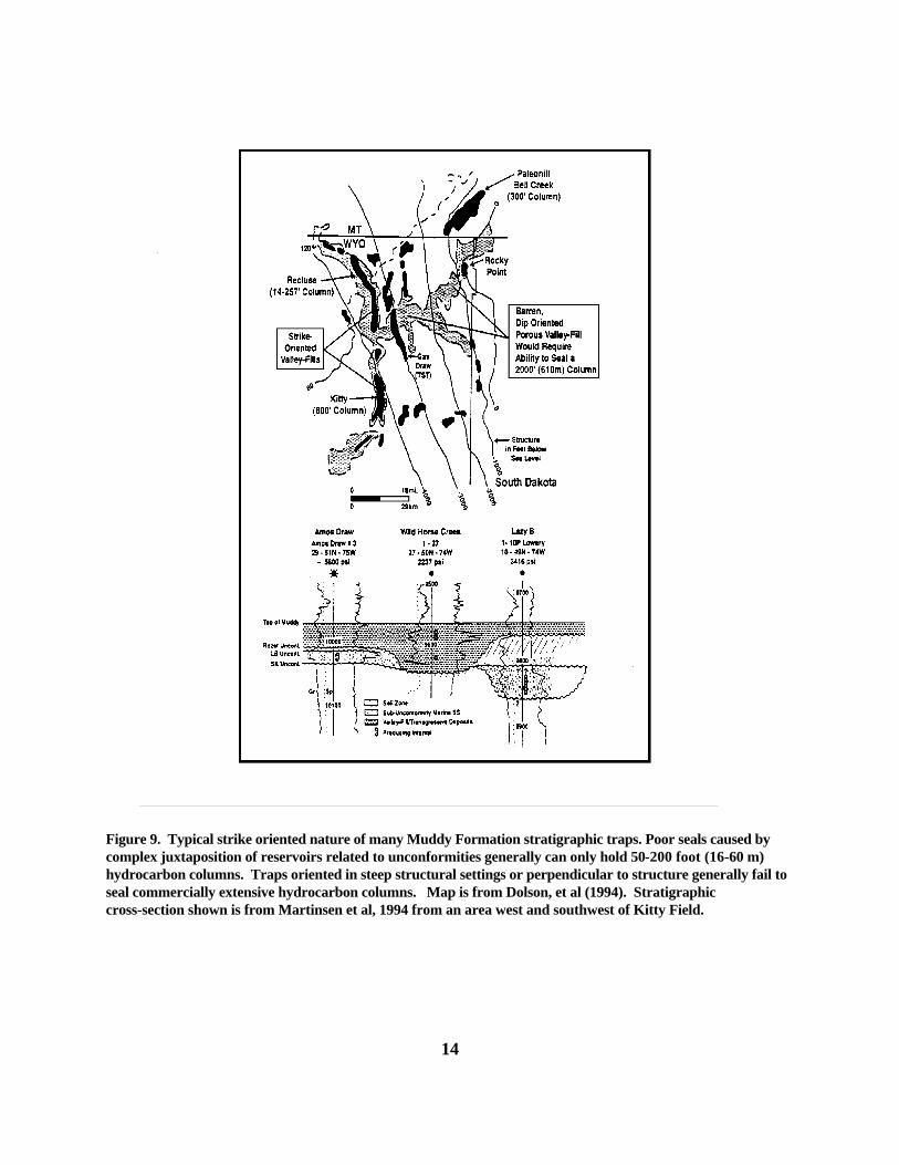
Figure 9. Typical strike oriented nature of many Muddy Formation stratigraphic traps. Poor seals caused bycomplex juxtaposition of reservoirs related to unconformities generally can only hold 50-200 foot (16-60 m)hydrocarbon columns. Traps oriented in steep structural settings or perpendicular to structure generally fail toseal commercially extensive hydrocarbon columns. Map is from Dolson, et al (1994). Stratigraphiccross-section shown is from Martinsen et al, 1994 from an area west and southwest of Kitty Field.

,
l
t
e
.
s
a
d
it
es,
d
st
tsd
w
le
e
upper Morrison as >140 Ma. In their subsurfacesection, well to the east of the Colorado Front Rangethe Lytle Sandstone is missing and the PlainviewSandstone rests unconformably on the MorrisonFormation. There appears to be ample evidence torefute the conclusion by Johnson (1991) that the basacontact with the Morrison is conformable. Both aeustatic sea-level drop and regional uplift have beenproposed to explain the widespread erosion of theMorrison Formation and the coarse grainedconglomerate sandstone at the base of the Lytle atmany locations (see Dolson, 1981 and 1985).
This stop will give us an opportunity ofexamine the inferred fluvial deposits of the Lytle inmore detail and to review some of the more importancharacteristics of the Morrison Formation. In generalthe Lytle is characterized by a complex lateralheterogeneity, numerous erosional surfaces, andsignificant variations in grain size and sedimentarystructures (Dolson, 1985). Sandstones exposed in thquarry are 66 ft (20.1 m) thick and composed of abasal quartz and clay clast conglomeratic sandstonethat grades up section into cross-bedded sandstonesCross-beds range from trough to planar, with troughsdominating the lower part of the section. Fracturedzones and large-scale cut and fill structures arecommon in parts of the section and medium- to small-scale, fining-upward cycles are common. Interbedded siltstone to mudstone units, common atother localities, are not characteristic of the exposedLytle in the quarry at Carter Lake. Along strikebetween Denver to the south and Boxelder Creek, tenof miles north of Fort Collins, the Lytle Sandstone isextremely variable in thickness (ranging from 50 to135 ft [15.2 to 41.1 m] thick) and in the location anddistribution of lithologies. North of Fort Collins theunit is characterized by a lower unit that grades from conglomeratic sandstone with horizontal beds andtrough cross beds to a sandstone characterized byplanar cross beds and an upper unit that is composeof mudstone and lenticular trough cross beddedsandstones with lateral accretion surfaces. The unitshave been interpreted as low sinuosity (probablybraided) deposits, and floodplain (coastal plain )/high sinuosity (probably meandering) stream depositsrespectively (Dolson, 1981 & 1985). To the south inthe Denver area the Lytle is even more variable than is north of Fort Collins. West of Denver someexposures are dominated by thick sandstone packagothers by mudstones with lenticular sandstones, andsome contain both units. Also the mudstone/lenticular
15
sandstone unit is not always at the top of the Lytlesuccession and may be sandwiched between thicksandstone units (Weimer et al, 1990). Significantrelief on the lower Lytle boundary coupled with thehigh lateral variability along depositional strike, theupward transition into paralic deposits of thePlainveiw, and the disappearance of Lytle to the eastin the subsurface all suggest that it was the result ofdeposition in large incised valleys along the westernmargin of the early Western Cretaceous Seaway.
Stop 4 — Highway 36, South of Hygiene RoadIntersection
Good exposures of the Skull Creek Shale anthe Fort Collins and Horsetooth members of theMuddy Sandstone are found at this road cut onHighway 36, south of Lyons, CO; Fig. 10; Sec. 32,T3N, R70W). Our purpose in stopping here is tocompare and contrast the upper portion of the DakotaGroup with that exposed at Stop 1 along the south-easided of Horsetooth Reservoir. The Skull CreekShale at this locality begins above the CS and consisof ripple cross-laminated, flaser bedded siltstones aninterbedded shales that contain vertical, sand-filledburrow tubes. Trails are common on bedding-planesurfaces. The Skull Creek Shale grades upward intoburrowed very fine-grained to fine-grained, clayeysandstones of the Fort Collins Member of the MuddySandstone. Trace fossils are abundant and includetypes similar to those at Stop 1, includingTeichichnus, Asterosoma, and Schanbcylindrichus(Terebelina). The Fort Collins Member ischaracterized by carbonaceous debris in the upper fefeet and is capped by a rooted zone. The HorsetoothMember exposed at this stop is significantly differentthan that found at Horsetooth Reservoir. It iscomposed of a thin succession of interbeddedcarbonaceous sandstones and shales with small-scacross beds and wavy bedding. The uppermostsandstone units contain Diplocraterian burrows andscattered chert pebbles. The thin Horsetooth sectionsuggests a location near the margin of a paleovalley(Fig. 5) and a merging of the LSE at the base of theHorsetooth and the TSE at the base of the overlyingMowry Shale. Further north at several locations thestwo unconformity surfaces merge on inferred inter-valley divides (Fig. 5).

16
Figure 10. Stratigraphic column of the Skull Creek Shale, and Fort Collins and Horsetooth members of theMuddy Sandstone exposed along Highway 36 south of Hygiene road intersection. Column is modified fromClark (1978) and Weimer, et al. (1990).

18
Acknowledgments
The authors of day one acknowledge thesupport and help of C. Kent Chamberlain for tracefossil identification and Guy Plint for hisunderstanding of gutter casts. We also thank thesecolleagues and John Dolson and Bob Weimer formany informative discussions on the rocks.

,
l in
f
o.grn
are
st
taarding
rn
ce
;
lythe
y-
ble
r,s ofd
s
at
DAY 2: PUEBLO, COLORADO TO CLAYTONNEW MEXICO
John Holbrook, Southeast Missouri State UniversityCape Girardeau, MO
Overview
Stops this day will be mixed in purpose. Atthe first stop, we will examine lithofacies architectureof Muddy valley-fill strata, and assess evidencesupporting presence of a continuous sequence-bounding unconformity within these valley fill strata. We will then visit Capulin Mountain, one of the bestpreserved basaltic cinder cones in North America, todiscuss Tertiary through Holocene volcanism in theHigh Plains of northeastern New Mexico. The daywill end with a stop at the Clayton Lake dinosaurtracksite. Here, we will investigate theinterrelationships between Lower Cretaceoussequence stratigraphy, Early Cretaceous dinosaurfauna, and track preservation potential on the"Dinosaur Freeway".
Regional Stratigraphic and Depositional Setting
The following discussion is extracted fromwork on Lower Cretaceous strata in southeasternColorado and northeastern New Mexico by Holbrook(1992, 1996) and Holbrook and Wright Dunbar (1992)to establish a regional stratigraphic and depositionaframework tieing Lower Cretaceous strata observedthe Front Range to that of southern High Plainsexposures.
The sequence-bounding lowstand surface oerosion (LSE) observed at the base of Plainviewstrata in the Ft. Collins area (surface SB2; afterWeimer and Sonnenberg, 1989) is continuoussouthward at least as far as east-central New Mexic It regionally separates the Plainview equivalent LonCanyon bed (basal Glencairn Formation; southeasteColorado and northeastern New Mexico) andCampana bed (basal Tucumcari Shale; east-centralNew Mexico) from underlying Morrison or Lytlestrata (Fig. 11). Long Canyon and Campana strata discontinuous, and, like the Plainview, represent localexpression of valley filling preceding Kiowa-SkullCreek transgression (T-5 of Kauffman, 1977). Lytlestrata is discontinuous beneath surface SB2 over moof the High Plains south of Colorado Springs, and isapparently absent south of northeastern New Mexico(Holbrook, et al, 1987).
19
The transgressive surface of erosion whichseparates Plainview from overlying Skull Creek strain the Front Range is also continuous as far southwas east-central New Mexico, and separates underlyLong Canyon, Campana, Lytle, or Morrison strata fromoverlying off-shore marine equivalents of the SkullCreek Shale within the upper Glencairn (southeasteColorado and northeastern New Mexico) andTucumcari (east-central New Mexico) formations(Fig. 11). This surface represents regionalravinement preceding Kiowa-Skull Creektransgression, and is draped regionally bytransgressive and regressive Skull Creek and SkullCreek equivalent offshore marine shale and shorefasandstone.
Basal Muddy (southeast Colorado) andequivalent Mesa Rica (northeastern New Mexico)fluvial sandstone are separated from underlyingGlencairn marine shale and sandstone by the 1992Dryer, 1994; Allen, 1993). Lithofacies Sf is hereinterpreted to represent tidal redistribution of fluvialderived sediments into subtidal bars and sheets at estuary head.
Subtidal bar/sheet strata interfinger lateralland vertically with thickly laminated-to-massive bluegray silty mudstone. These deposits closely resemthe open estuarine mud deposits which lie directlyseaward of subtidal bars in the Gironde estuary ofwestern France (Allen, 1993; Allen and Posamentie1993), and are interpreted to reflect ancient analogthese modern deposits. The rare sand stringers anminimal burrowing of lithofacies Fl are alsoconsistent with Gironde estuarine mud deposits(Allen, 1993; Allen and Posamentier, 1993).
Estuarine mud (Fl) and subtidal bars/sheet(Sf) may be overlain or underlain by less commonmedium-bedded sand of lithofacies Sihs (Table 1). Lithofacies Sihs bears the tidally generatedheterolithic features and upper shoreface marineichnofauna typical of lithofacies Sf; however, Sihsstrata are comparatively sandy and bear lateralaccretion surfaces. Lithofacies Sihs represents whThomas, et al (1987) termed inclined heterolithicstrata. Such marine-influenced inclined heterolithicstrata has been attributed to tidally influenced point-bar deposition by several authors

20
Figure 11. Correlation chart ogf major Lower Cretaceous formations and sequence stratigraphic b oundariesbetween the northern Front Range of Colorado and northeastern New Mexico.

21
Table 1. Lithofacies from Lower Cretaceous strata viewed on days two and three.
Code Lithology Characteristics Biota Environment
Stp Fine-to-medium-grained sandstone
Medium-scale trough and planarcross bedding; channel scourslocally with mud rip-up andpebble lags
Abundant plant fragmentimpressions; raredinosaur tracks; no significant burrowing
Fluvial
Spr Thick -to-verythick bedded fine-grained sandstone
Medium-scale planar crossbedded with subdominantcurrent and oscillation ripplelamination; herringbone crossbedding common; ripple-bounded planar forests common;bound by shallow wide channelscours, and scours areamalgamated
Plant fragmentimpressions common;burrows rare, and mostlyArenacolities
Tidal channel
Stpr Medium-to-verythick bedded fine-grained sandstoneinterbedded withblue-gray muddysiltstone
Sandstone - current andoscillation rippled and small-to-medium-scale planar and troughcross bedding; clay drapedripples rare but present locally;herringbone cross bedding andclay-draped planar cross-bedforesets in thickest bedsSiltstone - rippled-to-thicklylaminated
Abundant plant fragmentimpressions; local rootedhorizons; abundantdinosaur tracks; burrowsuncommon, but locallypresent and includeTeredolities, Planolities,Arenacolities, and rareThalassinoides
Fluvial/marinetransitional
Sfr Medium-to-thickbedded fine-to-medium-grainedsandstoneinterbedded withthin-to-very thinsiltstone beds
Sandstone - current rippled orsmall-scale planar cross beddedSiltstone - thickly laminated torippled Exposures are bound andinternally partitioned by channelscours
Abundant plant fragmentimpressions; nosignificant burrowing
Fluvial
Sihs Medium-to-verythickly beddedfine-grainedsandstoneinterbedded withthin-to-very thinbedded dark-graysilty mudstone
Sandstone - current andoscillation rippled or small-scale planar cross bedded;scours lined with clay rip-upslocally below sandstone beds;clay-draped ripples commonMudstone - thickly laminated-to-rippledBeds are parallel, and havedepositional dip ofapproximately 100
Lignite fragments andplant fragment moldscommon; burrowing isminimal overall andcomprises Teredolities,Planolities,Arenacolities, and rareThalassinoides
Tidallyinfluenced pointbar

SfThin-to-medium,tabular-to-slightlylenticular beds offine-grainedsandstoneinterbedded withthin-to-very thinbeds of blue-to-dark-gray siltyshale
Sandstone - mixed current andoscillation ripples gradinglaterally locally to small-scaleplanar cross bedding in thickerbeds; ripple foresets arecommonly clay draped; loadcasts commonSilty shale - thickly laminated torippled
Plant fragment and logimpressions; rare bivalvemolds; bioturbationminimal, but burrows andtrails are common andinclude Teredolities,Planolities,Arenacolities,Syphanities, Cruziana,Lockeia and rareThalassinoides
Subtidalbar/sheet
Fl Blue-gray siltymudstone andmuddy siltstonewith rare widelydispersed verythin beds of veryfine-grainedsandstone
Mudstone/siltstone - thickly/very thickly laminatedSandstone - current andoscillation rippled
Very minor burrowing Open estuary
Fm Medium to very thicklylaminated
Dark blue-gray thickbedded lenticularmudstone gradationalwith lithofacies Sfr
Fluvial(abandonedchannel fill)
le,
e
1).fta
o
hee
y
). d
ds
(Thomas, et al, 1987; Shanley, et al, 1992; Dalrympet al, 1992). Lithofacies Sihs is here interpreted torecord point-bar development in meandering tidalchannels and/or strongly tidally influenced fluvialchannels. southward continuation of the LSE (surfacSB3; after Weimer and Sonnenberg, 1989) whichseparates Fort Collins and Horsetooth strata in theColorado Front Range (Fig. 11). This surface istraceable southward into east-central New Mexicobeneath deltaic Mesa Rica Sandstone (Fig. 1 and 1 This LSE records regional exposure and incision oSkull Creek and Skull Creek equivalent marine strain eastern Colorado and northeastern New Mexicoduring Kiowa-Skull Creek lowstand (Fig. 11). Deltaic Mesa Rica strata in east-central New Mexicreflect shoreline progradation and lowstand wedgedeposition at maximum regression (Fig. 1). FluvialMesa Rica and overlying basal Pajarito strata innortheastern New Mexico represent deposition of acoastal/alluvial plain contemporary with Mesa Ricalowstand deltaic deposition to the south.
Muddy (southeastern Colorado) and Pajarito
22
(northeastern New Mexico) strata are equivalent to tHorsetooth Sandstone of the Front Range, and like thHorsetooth, represent coastal aggradation and vallefilling associated with onset of the Greenhorntransgression and renewed flooding of the WesternInterior. The existence of a transgressive surface oferosion in southeastern Colorado and northeasternNew Mexico that is equivalent to the transgressivesurface of erosion above Horsetooth strata is stillunresolved.
Stop 1: Muddy Valley-fill Exposures in theHuerfano Canyon Area
Lithofacies of Muddy valley-fill strata
The most common rocks in Muddy strata arecross-bedded sandstone of lithofacies Stp (Table 1Abundant channel scours, channel lags, amalgamatecross-bed sets, and lack of marine biota have ledseveral authors to render a fluvial channel and barinterpretation for these strata (Long, 1966; Jacka andBrand, 1972; Holbrook, 1996). These strata arelateral to, and commonly engulf, less common ripplelenticular unfossiliferous sandstone units of lithofacie

k,
o
il
,
by
e
of
.ss
e
,
tal
sf
hely
m
ary
Sfr (Table 1). Lithofacies Sfr strata have similarlybeen interpreted to represent channel deposits (Atali1984; Holbrook, 1996). Lithofacies Stp and Sfrtogether constitute a cliff-forming sandstone unit whichis consistently present at the base of Muddy strata. Inmost areas, these facies constitute a similar cliffformer at the top of Muddy strata that Long (1966)referred to as the upper Dakota sandstone. These twcliff-forming sandstone units are typically separatedby rocks of the lithofacies discussed below, but arelocally amalgamated.
The next most abundant lithofacies isburrowed interbedded sandstone and shale oflithofacies Sf (Table 1). Abundant clay-drapedripples and shale partings in these ripple-dominatedsandstone beds are typical of paralic rocks depositedunder tidal influence (Visser, 1980; Nio and Yang,1991; Shanley, et al, 1992). Likewise, the trace fossassemblage of this lithofacies is characteristic of anupper shoreface environment (Seilacher, 1964;Ekdale, et al, 1984). Taylor (1984), quite reasonablyattributed nearby examples of this lithofacies to tidal-flat deposition. More extensive lateral examination,however, reveals that these strata are not dissected tidal channels, and are more sand dominant thantypical tidal flats. Likewise, these deposits show nosigns of subaerial exposure (e.g., mudcracks). Lithofacies Sf more closely resembles low-energyversions of the subtidal bars and sheets observed inheadward regions of modern mixed wave and tidallydominate estuaries (Nio and Yang, 1991; Dalrymple,et al, 1992; Dryer, 1994; Allen, 1993). Lithofacies Sfis here interpreted to represent tidal redistribution offluvially derived sediments into subtidal bars andsheets at the estuary head.
Subtidal bar/sheet strata interfinger laterallyand vertically with thickly laminated-to-massive blue-gray silty mudstone. These deposits closely resemblthe open estuarine mud deposits which lie directlyseaward of subtidal bars in the Gironde estuary ofwestern France (Allen, 1993; Allen and Posamentier,1993), and are interpreted to reflect ancient analogs these modern deposits. The rare sand stringers andminimal burrowing of lithofacies Fl are alsoconsistent with Gironde estuarine mud deposits(Allen, 1993; Allen and Posamentier, 1993).
Lithofacies Stpr caps fluvial deposits overmost of the region and bears features of bothunderlying fluvial strata and overlying estuarine strata Strata are sand rich and ripple, trough, or planar crobedded. Locally, these strata exhibit marine tidal
23
features, such as clay-draped foresets or herringboncross bedding, and/or contain marine trace fossils. Root traces and abundant dinosaur tracks, howeverinfer that these strata were deposited in a largelyemergent environment. These strata intertounge withboth underlying fluvial and overlying estuarine strata,and are interpreted to represent the remains of coaslate-stage channel-fill and levee/splay complexeswhich were altered by tidal marine influence (c.f.Shanley, et al, 1992).
Several amalgamated shallow channel fillscrop out at one location in the Huerfano Canyon inscoured contact with underlying basal Muddy fluvialstrata. These sandy channel-fills contain abundantherringbone cross bedding and ripple-bound planarforesets, as well as the marine trace Arenacolities. These strata represent fills of small tidal channels.
Model for Muddy valley filling, and development ofan intra-valley-fill sequence boundary The lower two-thirds of the Muddy section fits wellwith the model for transgressive filling of a mixedwave and tidally influenced estuary proposed byDalrymple, et al, (1992) and Allen (1993). Aspredicted by this model, transgression promptedincreased meandering and marine flooding in streamof the estuarine coastal plain, prompting deposition otidally influenced inclined heterolithic strata (Sihs)and other fluvial/marine transitional deposits (Stpr)directly above basal Muddy fluvial sandstone (Figs. 12b and 13). Overlying subtidal bar/sheet and openestuary deposits represent transgression of the openestuary over underlying channel-derived lithofacies(Figs. 12c and 13). Although tidally influenced pointbar deposits (Sihs) are typically positioned betweenopen estuary and fluvial deposits, they may locallyoccur above open estuary strata (e.g. Fig. 13). Sucoccurrences likely record episodes of local shorelinregression owing to locally increased sediment suppin an overall transgressing system.
The above model infers that open estuarydeposits should be overlain by marine shorefacesandstone, or a more offshore deposit separated frounderlying estuarine strata by a wave and/or tidalravinement surface (Fig. 12c and d). This is not thecase in the Huerfano Canyon area. Here, open estudeposits are overlain by a sharp and regionally

24
Figure 12. Evolution of the Gironde estuary in western France from a) Wisconsin sea level lowstand, to B)Initiation of Holocene transgression, to C) Maximum Holocene flooding, to D) Modern approximate sea levelstillstand. (from Allen and Posamentier, 1993)
Figure 13. Sketch of facies distribution and sequence boundaries in exposure of the Muddy Formation at Stop 1,Day 2.

inerel
n
l
for
t
ase
m
,.
ry
our
ly
over
in
e
e
d
continuous subaerial erosion surface, above whichlyes fluvial sandstone (Fig. 13). This erosionalsurface has been traced continuously over 16kilometers of unbroken Huerfano Canyon exposure. The surface locally cuts through and removes estuardeposits and basal Muddy fluvial strata. Nowhere aopen marine deposits present between this erosionasurface and underlying estuarine strata.
Transgression and Muddy valley filling wasapparently interrupted by an episode of regression,which prompted scouring of existing estuarine fill anddevelopment of a lowstand surface of erosion aboveestuarine deposits. Deep levels of incision intounderlying strata suggest that scouring of this surfacewas accompanied by relative sea-level fall. Any opemarine strata deposited above estuarine fill wasapparently removed during this incisional episode.
Reinitiation of transgression prompted fluviadeposition above this lowstand surface of erosion,resulting in the Stp and Sfr fluvial strata regionally atthe top of the Muddy section (Fig. 13). These strataare capped by fluvial/marine transitional strata oflithofacies Stpr, which in turn are capped by offshoremarine deposits of the Graneros Shale. The reasonthis abrupt shift from marine-influenced fluvial toopen-marine strata is unresolved, but a waveravinement episode is suspected.
Previous workers made progress towardrecognition of a sequence boundary within Muddystrata. Waage (1953) and Long (1966) both noted thaupper Muddy fluvial sandstone deposits were locallyincised into lower fluvial units, and intervening fineswere removed at such locations. A sequenceboundary was actually proposed at this stratigraphiclevel by Hamilton (1989) for Muddy equivalentfluvial strata of central Kansas. He based this oncorrelative association of abrupt upward change influvial style and landward pinchout of the marineHuntsman Shale. He further proposed a link with thisinferred surface and the sequence-boundary at the bof the Lower Cretaceous D sequence of the DenverBasin. Lack of continuous exposure limited him tosparse point data. He was thus unable to laterallytrace a single surface, that could be distinguished froa series of unrelated channel diastems.
Regionally traceable examples of intra-valley-fill sequence-bounding unconformities are rareand have only been documented in a few cases (e.gAitken and Flint, 1994). Such sequence boundarieshave been inferred by upward changes in fluvial
25
architecture or abrupt transition from marine-influenced fluvial to fluvial deposition in a few othercases (e.g. Shanley and McCabe, 1991; Pattison andWalder, 1993). Muddy strata in the Huerfano Canyonarea contain a rare and significant example of atraceable sequence boundary entirely within valley-fill strata. This boundary reflects the paralic/coastalplain expression of a sea-level-related sequence-bounding unconformity.
Features visible at stop 1 The Plainview Formationis not present at this location, and sequence boundaSB2 and the transgressive surface of erosion at thebase of marine Glencairn strata exist as a single scsurface separating marine Glencairn shale fromconglomeritic Lytle Sandstone (Fig. 13). Glencairnstrata and the upper half of the Lytle section is largecovered here. Exposures are, however, apparentlocally.
The basal fluvial, the medial estuarine, andthe upper fluvial section of the Muddy Sandstone areexposed here. Each of the lithofacies discussed ablyes in its described stratigraphic position, except folithofacies Sihs which is higher in the section than itnormally occurs. The intra-valley-fill sequenceboundary at the base of the upper Muddy fluvialsandstone is readily traceable here, however,exposures of fluvial/marine transitional strata at thetop of the Muddy section are largely eroded. A sitewith five dinosaur tracks is located on the mesa rim the northern half of the exposure.
Stop 2: Capulin Mountain National Monument,New Mexico
The Raton-Clayton volcanic field
The Raton-Clayton volcanic field (RCVF)covers the approximately 130 km stretch between thtowns of Raton and Clayton, New Mexico (Fig. 14),and comprises the easternmost Cenozoic volcanicrocks in the western United States (Kudo, 1976). ThRCVF contains rocks of basaltic, andesitic, anddacitic composition that have been historicallysubdivided into the Raton Basalt, Clayton Basalt, ReMountain Dacite, and Capulin Basalt formations(Collins, 1949; Wood, et al, 1953; and Baldwin andMuehlberger, 1959). Not all of these formations arecompositionally distinct, and the Raton and Claytonbasalts contain rocks of more than one composition.Accordingly, definition of these formations has seenmore recent revisions (Kudo,
26
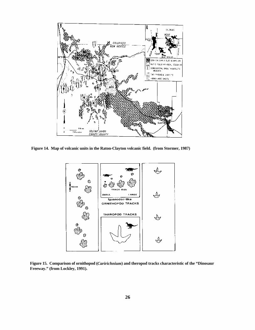
Figure 14. Map of volcanic units in the Raton-Clayton volcanic field. (from Stormer, 1987)
Figure 15. Comparison of ornithopod (Caririchnium) and theropod tracks characteristic of the “DinosaurFreeway.” (from Lockley, 1991).
of
hpartts
k
.2
s).
r,
d
ks
t
lt,
a
ydn
d
1976; Stormer, 1972 and 1987). This sectiondiscusses rocks of the RCVF in the order in whichthey erupted, while placing these rocks in theformational framework used by Baldwin andMuehlberger (1959).
The first eruptive phase took place between7.2 and 3.2 m.y. (Stormer, 1972), and covered muchthe western part of the RCVF with low-K and alkaliolivine basalts (Baldwin and Muehlberger, 1959; andStormer, 1987). These basalts presently cap the higmesas (Johnson and Canyon mesas) in the western of the RCVF, and are referred to as the Raton Basalby Baldwin and Muehlberger (1959). Raton low-Kbasalts are mildly alkalic, olivine basalts similar tocontinental olivine tholeiites (Stormer, 1987). Theserocks are interspersed with less common alkaliolivine basalts which bare common olivine andclinopyroxene phenocrysts (Stormer, 1987).
An eruptive event along the southwesternmargin of the RCVF about 2.7 m.y. produced the thicflows, domes, and plugs of the Red Mountain Dacite(Stormer, 1972). The Red Mountain Dacite ischaracterized by hornblende and plagioclasephenocrysts in a groundmass containing feldsparmicrolites and glass (Stormer, 1987).
A later phase of eruption between 2.5 and 2m.y. (Stormer, 1972) flooded the RCVF with theextensive basalts which presently cap the low mesabetween Capulin and Clayton, New Mexico (Fig. 14 These rocks are grouped into the Clayton Basalt byBaldwin and Muehlberger (1959) based on atopographic rather than compositional distinction. Compositionally, these rocks are similar to the RatonBasalt, and represent a continuation of maficvolcanism in the area.
Andesitic eruption about 1.9 m.y., producedthe prominent Sierra Grande shield volcano (Storme1972). These andesites are characterized by largeMg-rich orthopyroxene and smaller clinopyroxene anplagioclase phenocrysts, commonly in a glass-richgroundmass (Stormer, 1987). The Sierra Grandevolcano is the only major expression of this event. Baldwin and Muehlberger (1959) lumped the SierraGrande andesite into the Clayton Basalt; however,other workers (e.g., Kudo, 1976) consider these rocseparately.
Approximately 1.8 m.y. (Stormer, 1972), a
27
series of feldspathoidal basaltic eruptions took placein the region near Capulin Mountain (Fig. 14). Theresultant rocks are basanites and nephelinites withabundant phenocrysts of clinopyroxene and olivine(Stormer, 1987). Baldwin and Muehlberger (1959)lumped these rocks primarily into the Clayton Basalt.
The last eruptive phase in the RCVFproduced the Capulin Basalt (18,000 - 4,500 years;Baldwin and Muehlberger, 1959). Capulin volcanicsare xenocrystaline silicic alkalic basalts and basalticandesites (Stormer, 1987). The most distinctivefeature of these rocks is the local (especially in flowsfrom Capulin Mountain) presence of large resorbedquartz and reverse-zoned plagioclase grains in direcassociation with abundant olivine phenocrysts(Stormer, 1987).
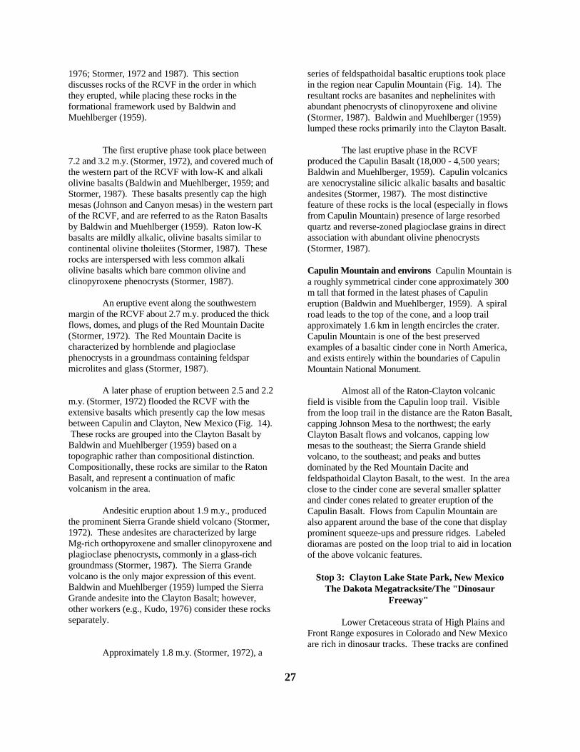
Capulin Mountain and environs Capulin Mountain isa roughly symmetrical cinder cone approximately 300m tall that formed in the latest phases of Capulineruption (Baldwin and Muehlberger, 1959). A spiralroad leads to the top of the cone, and a loop trailapproximately 1.6 km in length encircles the crater. Capulin Mountain is one of the best preservedexamples of a basaltic cinder cone in North America,and exists entirely within the boundaries of CapulinMountain National Monument.
Almost all of the Raton-Clayton volcanicfield is visible from the Capulin loop trail. Visiblefrom the loop trail in the distance are the Raton Basacapping Johnson Mesa to the northwest; the earlyClayton Basalt flows and volcanos, capping lowmesas to the southeast; the Sierra Grande shieldvolcano, to the southeast; and peaks and buttesdominated by the Red Mountain Dacite andfeldspathoidal Clayton Basalt, to the west. In the areclose to the cinder cone are several smaller splatterand cinder cones related to greater eruption of theCapulin Basalt. Flows from Capulin Mountain arealso apparent around the base of the cone that displaprominent squeeze-ups and pressure ridges. Labeledioramas are posted on the loop trial to aid in locatioof the above volcanic features.
Stop 3: Clayton Lake State Park, New MexicoThe Dakota Megatracksite/The "Dinosaur
Freeway"
Lower Cretaceous strata of High Plains andFront Range exposures in Colorado and New Mexicoare rich in dinosaur tracks. These tracks are confine

ts
se
w
;
ry
y
dhle
s
t
a
al-
a
s
e,
is8
o
almost entirely to the Pajarito Formation innortheastern New Mexico, and to Pajarito equivalenof the upper Muddy Sandstone in southeasternColorado and the Colorado Front Range. Within thestrata, Lockley, et al, (1992) document over 1300tracks within 25 sites dispersed over an 80,000+ km2
area between Boulder, Colorado and Mosquero, NeMexico. Such regional-scale and stratigraphicallyrestricted track-bearing complexes are commonlyreferred to as "megatracksites" (Lockley, et al, 1988Lockley and Pittman, 1989). The Dakotamegatracksite is informally referred to as the"Dinosaur Freeway" (Jones, 1988; Lockley, 1988,1990).
Most tracks in the Dakota megatracksitebelong to the ichnogenra Caririchnium andAmblydactylus (Gillette and Thomas, 1985; Lockley,1987; Lucas, et al, 1987). These ichnogenra are vesimilar. Their main distinction is the presence of abilobate heel in the pes print and the association of asmall manus print in Caririchnium; both featuresbeing normally absent in Amblydactylus (Leonardi,1984; Currie and Sarjeant, 1979; Fig. 15). BothCaririchnium and Amblydactylus occur throughout theDakota megatracksite, and represent tracks made byherbiferous ornithopods of iguanadontid taxa(Lockley, et al, 1992). Unclassified theropod tracksfound in association with ornithopod tracks arecharacterized by slender toe impressions with widedigit divarication, and are presumably the tracks ofgracile "coelurosaurians" (Lockley, et al, 1992; Fig. 15). Ornithopod tracks out-number theropod tracks bmore than four-to-one throughout the Dakotamegatracksite. Dinosaur tracks are locally associatewith a few bird and/or crocodile tracks as well. Eacof the track types above appear to be found in variababundance throughout the Dakota megatracksite(Lockley, et al, 1992).
The regional abundance of ornithopod trackin such a thin stratigraphic interval prompted someworkers to speculate that the Dakota megatracksiterecords an ancient coastal migration route forherbiferous dinosaurs (Monastersky, 1988; Black,1989; Boling, 1989). Indeed, many authors argue thalarge herbiferous dinosaurs like iguanadons wouldhave been forced to migrate to avoid hunger as theylocally outstripped their food supply (cf. Hotton,1980; Calder, 1984). In examining these strata fromsequence stratigraphic viewpoint, Lockley, et al,(1992) determined that such an interpretation wasoverly simplistic. They noted that because Pajaritoand equivalent strata predominantly represent coast
28
plain aggradation and valley filling preceding up-dip(south-to-north) transgression (Holbrook and WrightDunbar, 1992; Fig. 6), the Pajarito formation of thesouth is likely older than the stratigraphicallyequivalent track-bearing strata to the north. It is thusunlikely that northern and southern track-bearing stratwere deposited concurrently, and that any singlenorth/south migration path would be preserved. Morelikely, the Dakota megatracksite records northwardstepping of a coastal dinosaur community withencroachment of the Western Interior sea, coupledwith preferential preservation of tracks in the"preservation-friendly" coastal environments typicalof Pajarito strata (Lockley, et al, 1992). Such andinterpretation would mean that the abundance of trackin the Dakota megatracksite only reflects a section ofpreferential preservation in the stratigraphic sequencand neither supports or precludes the possibility thatthe fore mentioned coastal dinosaur communitymigrated.
The Clayton Lake Track Site The Clayton Laketracksite covers an area of approximately 1/2 hectarewithin the floor of the overflow spillway of ClaytonLake, approximately 18 km north of Clayton, NewMexico. Nearly 500 tracks in excellent to poorcondition are preserved here in three stratigraphicunits which span the Mesa Rica/Pajarito boundary(Gillette and Thomas, 85; Fig. 16; a map oftrackways is posted at the Clayton Lake site). Tracksare tightly spaced and difficult to distinguish locally,as is typical of such "dinoturbation" surfaces (Lockley,1991). Tracks are best observed in the oblique lightof early morning and late evening.
The lower-most track-bearing horizon is onthe upper surface of the Mesa Rica Sandstone. TheMesa Rica Sandstone is a planar and trough cross-bedded cliff-forming fluvial sandstone (LithofaciesStp; Table 1) 12.8 m thick at the site. Tracks on theupper Mesa Rica surface are associated withThalassinoides burrows. The second track-bearingbed is on the top surface of a .3 m thick fine-grainedrippled-to-massive quartzose sandstone bed, which separated from the underlying Mesa Rica by only a .0m thick siltstone layer. The third track-bearing layeris .9 m above the second, and is on top of a .5 m bedof very-fine-grained rippled-to-massive sandstone. The second and third layers are separated by thinly tvery thinly interbedded sandstone and silty shale. Track-bearing beds two and

29
Figure 16. Stratigraphic sections from “Dinosaur Freeway” track sites at Clayton Lake State Park, andsurrounding areas. (from Lockley, et al, 1992).
s
,
e
d
;
three are in the basal Pajarito Formation, and weredeposited in the fluvial/marine transitionalenvironments described above (lithofacies Sf; Table 1).
Tracks at the Clayton Lake site reflectornithopod, theropod, and crocodillian track makers. Ornithopod tracks here are up to 50 cm long and 42cm wide, and are identified by Gillette and Thomas(1985) as all belonging to the ichnogenousAmblydactylus. Gillette and Thomas (1985) andLucas, et al (1986) contended that Clayton Lake trackwere made by hadrosaurs, whereas Lockley, et al,(1992) argue that such Amblydactylus printsthroughout the Dakota megatracksite were made byiguanadonts. Most all theropod tracks at the ClaytonLake site are less than 28 cm long, and represent theslender-toed coelurosaur tracks typical of the Dakotamegatracksite (Gillette and Thomas, 1985). Twolarger, poorly preserved theropod tracks are up to 35cm long with fatter toes and less digit divaricationthan the more typical coelurosaur tracks. Gillette andThomas (1985) proposed that these might bethe tracks of a carnosaur. An enigmatic diamond-shaped track type is common at the Clayton Lake sitebut rare in the Dakota megatracksite overall. Gilletteand Thomas (1985) proposed that this represented thtrack of a web-footed theropod; however, Lockley, etal (1992) contended that these tracks most likelyrepresent a sediment-deformed ornithopod track. Ifthe diamond-shaped tracks are truly theropod tracks,then theropod tracks are only slightly less abundantthan ornithopod tracks; whereas, if these tracks recorornithopods, than theropods produced only about 20%of the trackways at the Clayton Lake site.
Approximately 50 trackways can beidentified at the Clayton Lake site, including a fewcrocodillian trackways (Lockley, et al, 1992). Trackways do not appear to have a preferredorientation overall at Clayton Lake, although sometrackways parallel each other (Gillette and Thomas,1985). A tracksite just south near the town ofMosquero, New Mexico, however, does display 114similar ornithopod tracks (mostly Caririchnium) in 31trackways that are clearly bimodally oriented NW-SEand occur at the same stratigraphic level as tracks atClayton Lake (Lucas, et al, 1987; Lockley, et al, 1992Fig. 16).
30

DAY 3: DRY CIMARRON VALLEY OF NORTHEASTERN NEW MEXICO
John Holbrook, Southeast Missouri State University, Cape Girardeau, MO
ry
d-
s
t
y
k-
,g
one
ill
)ts
y
rm
aire
ghe
OverviewAll three stops this day will give us the
opportunity to compare the interrelationships betweensequence-boundary morphology and architecture ofoverlying strata for up-dip and down-dip areas in asequence, namely, sequence 3 of Weimer andSonnenberg (1989). Morphology of sequence boundaSB3 is smooth, and overlying fluvial Mesa RicaSandstone is only one channel thick in Dry Cimarronexposures. This contrasts with equivalent strata seenup paleodepositional dip in the Ft Collins area on dayone. There, sequence boundary SB3 had a valley-aninterfluve morphology, and fluvial HorsetoothSandstone was confined to SB3 lows. We will discusdifferences in the fluvial and erosional processesresponsible for this down-dip shift in sequencestructure.
Later in the day, at stops two and three, wewill compare architecture of the Mesa Rica Sandstoneover different segments of the Sierra Grande basemenstructure. We will discuss how subtlecontemporaneous uplift on Sierra Grande structure mahave influenced Mesa Rica deposition. For time'ssake, we will probably not venture to the top of themesa at stop 3, but rather will observe pertinentfeatures from the valley floor.
Stop 1: Interrelationships between Mesa RicaSandstone Architecture and Morphology
of Underlying Sequence Boundary SB3 in the DryCimarron Valley
Architectural features of Mesa RicaSandstone/basal Pajarito strata and morphology ofsequence boundary SB3 Mesa Rica Sandstone in theDry Cimarron valley is dominated by channel-fill andlateral-accretion elements, and is capped by overbanfine, channel-fill, and sandy-bedform elements of thebasal part of the Pajarito Formation. Otherarchitectural elements are conspicuously absent.
Channel-fill elements are the dominantelement in Mesa Rica strata throughout northeasternNew Mexico, and are roughly symmetrical, withwidth/depth ratios of ≈ 9 - 15 (Figs. 17, 18, and 19). Channel fills mostly contain deposits of lithofacies Stpwhich are interpreted to represent active channel fillin(Holbrook, 1996; Fig. 17; Table 1). Some, however,
31
are partly filled by massive dark blue-gray mudstonemore appropriately attributed to abandoned channel-filling processes (Lithofacies Fm; Table 1). Mostchannels containing such abandoned channel fillcomprise a secession of basal Stp and/or Sfr sandstand upper massive mudstone (Fig. 18; Table 1).
Lateral-accretion elements are locallycommon, but rarely dominant, in Mesa Rica strata. Where present, they lie directly adjacent to channel-felements, and consist of lithofacies Stp strata (Fig. 18). They typically are 30% - 100% (averaging 65%the width of adjacent channel elements. Paleocurrenfrom trough and planar cross beds in channel-fill andlateral-accretion elements yield generally south andsoutheastward vectors.
Interbedded sandstone and siltstone in thebasal two meters of the Pajarito Formation are largelcomposed of lithofacies Stpr, and are considered torepresent stacked sandy bedform and thin overbank-fine elements. These overbank-fine and sandy-bedfoelements locally interfinger with and/or engulf smalland large channel-fill elements of the basal Pajaritosection (Fig. 17).
Physical correlation verifies that the MesaRica Sandstone overlies sequence boundary SB3 assingle continuous sandstone sheet throughout the entlength of the Dry Cimarron valley (Holbrook, 1996;Fig.: 20). Mesa Rica thickness also correspondsconsistently with thickness of the larger channel-fillelements (Figs. 17, 18, and 19). The result is awidespread (> 87 km along strike) continuoussandstone sheet that is essentially one channel thick.Relief on sequence boundary SB3, relative to thetransgressive surface of erosion above the underlyinPlainview equivalent Long Canyon bed, is less than tthickness of overlying channel elements (Fig. 20). Relief on this surface is thus not attributed to majorvalley development, and sequence boundary SB3 isthus judged to be smooth (Holbrook, 1996).
Mesa Rica and basal Pajarito strata lie
32
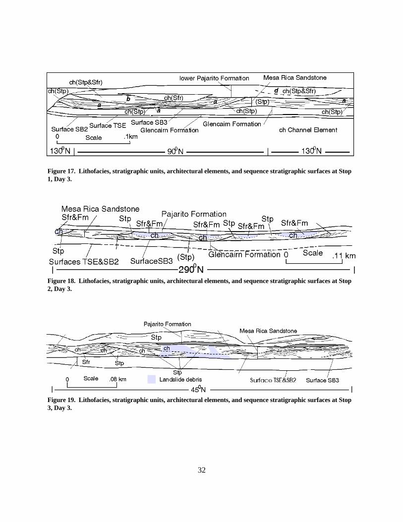
Figure 17. Lithofacies, stratigraphic units, architectural elements, and sequence stratigraphic surfaces at Stop1, Day 3.
Figure 18. Lithofacies, stratigraphic units, architectural elements, and sequence stratigraphic surfaces at Stop2, Day 3.
Figure 19. Lithofacies, stratigraphic units, architectural elements, and sequence stratigraphic surfaces at Stop3, Day 3.

neent
d.
a
inls
d
ls
ss
of
l
a-
t-
on
d
d
directly above the sequence boundary seen on day oat the base of the Horsetooth Sandstone, and represthe down-dip equivalents of these Horsetooth strata(Holbrook and Wright Dunbar, 1992). Association ofa single-story sandstone sheet above a smoothsequence boundary in the Dry Cimarron valley,however, contrasts sharply with the discontinuoussandstone units confined to discrete valleys observein equivalent Horsetooth strata of the Ft. Collins area
Mesa Rica River Patterns Lithofacies andarchitectural features of the Mesa Rica Sandstoneimply that these strata resulted from amalgamation ofchannel-derived deposits, which were generated by complex of non-braided straight to low-sinuositystreams (Holbrook, 1996). Several lines of evidenceare used by Holbrook (1996) to support thisinterpretation over a more meandering or braidedmodel. These include preponderance of individuallyincised symmetrical to near symmetrical channel fills(c.f. Moody-Stuart 1966; Tyler and Ethridge 1983);highly subordinate role of lateral accretion elements Mesa Rica architecture; close association of channewith levee/splay deposits, indicating channelconfinement; low channel width/depth ratios;conspicuous lack of architectural elements typicallyassociated with braided deposits (e.g., foresetmacroforms; see Miall 1985); presence of abandonechannel-fill elements; and regional similarity inchannel-element geometry and scale. Mostimportantly, photopans reveal that Mesa Rica channeaggraded from the Mesa Rica Sandstone sheet asindependent channel bodies (Fig. 7). In contrast,minor braided-channel fills should have aggradedcollectively, as part of a complex of amalgamatedchannel fills and bars within a larger, braidedchannel-fill element. Mesa Rica lateral-accretionelements represent preservation of narrow point barwhere Mesa Rica streams ranged into slightly sinuoupatterns.
Most abandoned channel fills compriseinterbedded active-channel-fill and abandoned-channel-fill deposits, a feature typical of channel fillsformed after abandonment by chute cutoff (Allen,1965). Such fills may represent either abandonmentchannels by chute cutoff in low-sinuosity streams, orabrupt abandonment of longer reaches of channelfollowed by episodic reoccupation during floods. Basal Pajarito strata directly atop Mesa Rica channesandstone represent preservation of levee/splaycomplexes.
33
Model for Mesa Rica deposition and its sequence-stratigraphic significance Fluvial Mesa Rica sheetsandstone and basal Pajarito strata in the DryCimarron area comprise channel and floodplaindeposits, respectively, of an extensive (> 87 km wideand ≈ 100 km long) coastal plain which developedduring Kiowa-Skull Creek lowstand (Holbrook 1992;Holbrook and Wright Dunbar 1992). In contrast,equivalent fluvial/estuarine strata of the Horsetoothmember farther up dip in central and southeasternColorado are confined to discrete valleys, andrepresent mostly filling of valleys during transgressionwhich followed Mesa Rica deposition (Weimer 1984;Dolson et al 1991; Holbrook 1992, 1993). Mesa Ricand basal Pajarito depositional history and sequencestratigraphy are discussed at length in Holbrook(1996). The following discussion summarizes theseconclusions.
During Kiowa-Skull Creek lowstand, MesaRica rivers delivered sediment from regionsthroughout the exposed mid-section of the WesternInterior to a marine shoreline in northeastern and eascentral New Mexico. Delivery of sediment underproposed stable relative sea level conditions atlowstand prompted rapid shoreline progradation. Coastal Mesa Rica rivers were forced to transportsediment progressively farther over near zerogradients to reach marine depocenters as progradatiproceeded. Straightening and frequent avulsion ofthese coastal Mesa Rica rivers ensued as a complexfluvial response to the low gradients imposed by rapiprogradation, much like in the case of the modernYellow River of China (see Van Gelder, et al, 1994). Similar fluvial responses to low gradients during sealevel lowstand are also predicted by conceptual(Posamentier, et al, 1992; Wescott, 1993; Schumm,1993) and flume models (Koss, et al, 1994).
Proposed prolific avulsion of relativelystraight Mesa Rica rivers throughout the coastal plainunder these conditions of low accommodation spaceeventually resulted in deposition of a regionallycontinuous Mesa Rica fluvial sandstone sheet, andplanation of underlying marine strata in coastal plainareas. This culminated in the distinctive geneticassociation of single-story fluvial sheet sandstone ansmooth sequence-boundary morphology that isapparent in Mesa Rica Sandstone and underlyingsequence boundary SB3 in the Dry Cimarron valley(Fig. 3). This contrasts markedly with the valley-fillscenario which addressed the discontinuousHorsetooth strata above a highly incised sequence
al
p
toal
e
er
s
er
as
.
t
boundary SB3 that was observed up paleodepositiondip near Ft. Collins on the first day. There, long-termexposure and significant base-level drop duringKiowa-Skull Creek lowstand prompted deep incisionof local valleys that were filled during subsequenttransgression. Colorado Front Range (Horsetooth)and New Mexico (Mesa Rica and Pajarito) sectionsprovide an excellent example of large-scale down-dishift in sequence-boundary morphology andarchitecture of overlying strata that can be attributed contrasting response of lowstand rivers from erosionvalley incision in the hinterland to lateral planationand sheet sandstone deposition near the lowstandshoreline.
Transgression and associated base-level risthat followed maximum Kiowa-Skull Creek regressionprompted fluvial aggradation and burial of regressiveMesa Rica and basal Pajarito deposits beneath anextensive blanket of marine-influenced lower Pajaritocoastal-plain strata.
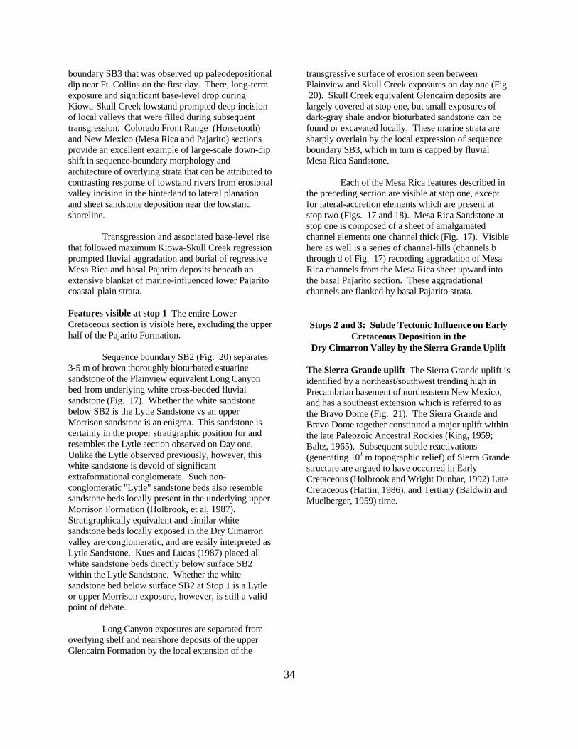
Features visible at stop 1 The entire LowerCretaceous section is visible here, excluding the upphalf of the Pajarito Formation.
Sequence boundary SB2 (Fig. 20) separate3-5 m of brown thoroughly bioturbated estuarinesandstone of the Plainview equivalent Long Canyonbed from underlying white cross-bedded fluvialsandstone (Fig. 17). Whether the white sandstonebelow SB2 is the Lytle Sandstone vs an upperMorrison sandstone is an enigma. This sandstone iscertainly in the proper stratigraphic position for andresembles the Lytle section observed on Day one. Unlike the Lytle observed previously, however, thiswhite sandstone is devoid of significantextraformational conglomerate. Such non-conglomeratic "Lytle" sandstone beds also resemblesandstone beds locally present in the underlying uppMorrison Formation (Holbrook, et al, 1987). Stratigraphically equivalent and similar whitesandstone beds locally exposed in the Dry Cimarronvalley are conglomeratic, and are easily interpreted Lytle Sandstone. Kues and Lucas (1987) placed allwhite sandstone beds directly below surface SB2within the Lytle Sandstone. Whether the whitesandstone bed below surface SB2 at Stop 1 is a Lytleor upper Morrison exposure, however, is still a validpoint of debate.
Long Canyon exposures are separated fromoverlying shelf and nearshore deposits of the upperGlencairn Formation by the local extension of the
34
transgressive surface of erosion seen betweenPlainview and Skull Creek exposures on day one (Fig 20). Skull Creek equivalent Glencairn deposits arelargely covered at stop one, but small exposures ofdark-gray shale and/or bioturbated sandstone can befound or excavated locally. These marine strata aresharply overlain by the local expression of sequenceboundary SB3, which in turn is capped by fluvialMesa Rica Sandstone.
Each of the Mesa Rica features described inthe preceding section are visible at stop one, exceptfor lateral-accretion elements which are present atstop two (Figs. 17 and 18). Mesa Rica Sandstone astop one is composed of a sheet of amalgamatedchannel elements one channel thick (Fig. 17). Visiblehere as well is a series of channel-fills (channels bthrough d of Fig. 17) recording aggradation of MesaRica channels from the Mesa Rica sheet upward intothe basal Pajarito section. These aggradationalchannels are flanked by basal Pajarito strata.
Stops 2 and 3: Subtle Tectonic Influence on EarlyCretaceous Deposition in the
Dry Cimarron Valley by the Sierra Grande Uplift
The Sierra Grande uplift The Sierra Grande uplift isidentified by a northeast/southwest trending high inPrecambrian basement of northeastern New Mexico,and has a southeast extension which is referred to asthe Bravo Dome (Fig. 21). The Sierra Grande andBravo Dome together constituted a major uplift withinthe late Paleozoic Ancestral Rockies (King, 1959;Baltz, 1965). Subsequent subtle reactivations(generating 101 m topographic relief) of Sierra Grandestructure are argued to have occurred in EarlyCretaceous (Holbrook and Wright Dunbar, 1992) LateCretaceous (Hattin, 1986), and Tertiary (Baldwin andMuelberger, 1959) time.

35
Figure 20. Cross section of Lower Cretaceous strata in the Dry Cimarron valley with Stops 1, 2, and 3, marked
.
Figure 21. Contour map of precambrian basement in northeastern New Mexico. (modified from Suleiman andKeller, 1985)

36
Figure 22. Isopach map of Glencairn strata, excluding the Long Canyon sandstone bed.
Figure 23. Architectural element distribution in the Dry Cimarron Valley area.
s
ra
t.
f
a
is
a
y-
te,ase
rs a
ss
e
s
sa
lt
2,
. Aver
ty
).
e
our
y
isg
y
Tectonic influence on the Glencairn Formation Deflection of the marine Glencairn zero isopachcontour, and parallel thickness contours, approximatethe shape of Precambrian relief on the combinedSierra Grande and Bravo Dome basement structure(Figs. 21 and 22). Mesa Rica paleocurrents andthickness trends in Muddy equivalent valley fill strataare oriented perpendicular to the Sierra Grande axisfor areas above and west/up depositional dip of SierGrande structure. Preferential thinning of Glencairnstrata over Sierra Grande structure is thus not anartifact of valley development and incision ofGlencairn strata parallel with the Sierra Grande cres
Pinchout of marine Glencairn stratacoincident with the eastern and northwestern flanks othe Sierra Grande uplift infers non-deposition ofmarine strata over an elevated Sierra Grande weltduring Kiowa-Skull Creek marine flooding, and/orpreferential erosion of previously deposited Kiowa-Skull Creek marine strata above a rising SierraGrande welt during lowstand erosion of surface SB3.In either case, such close coincidence of basementstructure and marine stratal thickness infers effects onmarine Glencairn strata by topography generatedabove a Sierra Grande uplift which was rising eitherprior to, during, or shortly after Kiowa-Skull Creekmarine flooding (Holbrook, 1992).
Tectonic influence on Mesa Rica Sandstone Down-dip continuation of Mesa Rica deposits over the SierrGrande axis (Figs. 20, 22, and 23) infer that anytopography above the Sierra Grande structure,coincident with Mesa Rica deposition, wasinsufficient to cause deflection of Mesa Rica streamsand preferential valley development off the SierraGrande flanks. Regional variations in Mesa Ricaarchitecture, however, speak of extremely subtleinfluence on Mesa Rica fluvial deposition bycontemporary uplift on Sierra Grande basementstructure.
As discussed above, Mesa Rica Sandstone composed of active-channel-fill, abandoned-channel-fill, and lateral-accretion elements throughout the DryCimarron valley; however, regional distribution ofthese three elements is not random. Mesa Rica stratin all Dry Cimarron exposures west and greater than20 km east of the Sierra Grande axis are dominated bactive-channel-fill elements, and abandoned-channelfill and lateral-accretion elements are rare in theseareas (Figs. 17, 19, and 23). The stretch of MesaRica exposure from the Sierra Grande axis eastwardfor 20 km is rich in abandoned-channel-fill and
37
lateral-accretion elements. Active-channel-fillelements are common, but comparatively subordinain this area (Figs. 18 and 23). The observed increin lateral-accretion element size and abundancereflects more extensive point bar growth locally, andabundance of abandoned-channel-fill elements infelocal increase in chute cutoff of stream meanders. This clear change in Mesa Rica architecture signifiea relative increase in sinuosity for Mesa Rica streamin reaches extending over thesoutheastern/downstream flank of the Sierra Granduplift (Holbrook, 1992, 1994; Fig. 23). Maximumsinuosities calculated for these more sinuous streamfrom lateral-accretion sets is only 1.2 (see Leopoldand Wolman, 1957), and is thus still very low(Holbrook, 1996).
Strong coincidence between increased MeRica channel sinuosity and the Sierra Grande eastflank is attributed to fluvial response to elevatedgradients encountered by Mesa Rica rivers on thesoutheastern/downstream flank of a topographic werising penecontemporaneously above reactivatedSierra Grande basement structures (Holbrook, 1991994). Such local increases in sinuosity owing tolocal elevation of gradient is well document inexperimental flume studies (Friedkin, 1945; Schummand Khan 1972; Ouchi, 1985; Schumm, et al, 1987)modern example of the sinuosity effects proposed othe Sierra Grande uplift is seen on the modernMississippi River of southeastern Missouri. As theriver passes over the crest of the active Lake Counuplift (30 feet topographic relief), it increases insinuosity on the steepened downstream flank of thisstructurally generated topographic welt (Russ, 1982
Features visible at stop 2 Neither the Plainviewequivalent Long Canyon bed nor the Lytle Sandstonare present at this location, and sequence boundarySB2 and the transgressive surface of erosion at thebase of marine Glencairn strata exist as a single scsurface separating marine Glencairn shale fromunderlying green and red mudstone of the MorrisonFormation (Fig. 18). Glencairn strata is largelycovered here, and exposures must be excavated.
Mesa Rica strata above sequence boundarSB3 at this location is dominated by abandoned-channel-fill elements. We will concentrate on atypical example of an abandoned channel fill which located approximately 40 m west of the road passinup to the mesa top. This channel fill is floored byrocks of lithofacies Stp, which are in turn overlain broughly equal proportions of lithofacies Sfr. The

s
d
,a
an
n
,
ies in
.,
. 3-
celley
.
s in
:
ent
.
ic
es
n-
.
8.
remaining quarter of this channel is filled by massiveto thickly laminated blue-gray mudstone (Fig. 18). Mesa Rica Sandstone in the area is continuous, buthigh mud content, related to local abundance ofabandoned-channel-fill elements, results in poorexposure.
Mesa Rica strata are capped byfluvial/marine transitional deposits of lithofacies Stpr,which are in turn capped conformably by mudstone ofunknown origin that is similar to lithofacies Fl. Thesemudstone strata are capped by a second horizon oflithofacies Stpr strata. Laterally, these mudstone bedsare separated from overlying Stpr strata bydiscontinuous lenses of lithofacies Stp fluvial strata . These Stp strata could possibly represent equivalentof the upper fluvial sandstone beds of the Muddy thatwere observed at stop one on day two.
Features visible at stop 3 Rainfall in this part of theDry Cimarron valley is greater, resulting in poorerstratal exposure. Only the upper 3 m of aconglomeratic Lytle Sandstone are exposed here, anare overlain by conglomeritic bioturbated brownsandstone of the Long Canyon bed. These units areonly locally exposed. The transgressive surface oferosion at the top of the Long Canyon bed ischaracterized by a thin lag of Gryphea shells at thislocation.
Mesa Rica Sandstone is composed almostentirely of active-channel-fill elements at this locationand more closely resembles exposures at stop one ththose of stop two. A thin layer of fluvial/marinetransitional strata (lithofacies Stpr) overlies MesaRica Sandstone which is in turn overlain in scouredcontact by a cliff of fluvial Stp strata. Locally, theseupper fluvial sandstone beds are incised into MesaRica Sandstone, and the intervening transitional stratare removed. This upper fluvial sandstone is likely aequivalent of the upper Muddy fluvial sandstoneobserved at stop one of day two.
ACKNOWLEDGMENTS
Funding for research presented at all stops oDay 2 and Day 3, except Stop 2 on Day 2, wasprovided by the Petroleum Research Fund of theAmerican Chemical Society, with additional supportfrom the Geological Society of America, AmericanAssociation of Petroleum Geologists, Sigma Xi, andSoutheast Missouri State University. Special thanksgo to Donald Hattin, Lee Suttner, Michael Hamburgerand John Droste for useful input during the completion
38
n
of this research.
REFERENCES CITED
Allen, J.R.L., 1965, A review of the origin andcharacteristics of recent alluvial sediments: Sedimentology, v. 5, p. 89-191.
Allen, G.P., 1993 Sedimentary processes and facthe Gironde estuary: A recent model formacrotidal estuarine systems, in Smith, D.G.,Reinson, G.E., Zaitlin, B.A., and Rahmani, R.A(eds.), Clastic Tidal Sedimentology: CanadianSociety of Petroleum Geologists Memoir 16, p28
Allen, G.P. and Posamentier, H.W., 1993, Sequenstratigraphy and facies model of an incised vafill: the Gironde Estuary, France: Journal ofSedimentary Petrology, v.63, no.3, p.378-391
Aitken, J.F. and Flint, S.S., 1994, High-frequencysequences and the nature of incised-valley fillfluvial systems of the Breathitt Group(Pennsylvanian), Appalachian foreland basin,Eastern Kentucky in Dalrymple, R.W., Zaitlin,B.A., Scholle, P.A. (eds.), Incised-valleySystems: Origin and Sedimentary SequencesSociety of Sedimentary Geology SpecialPublication 51, p. 353-368.
Atalik, E., 1984, Depositional facies and environmof the Dakota Sandstone in northwesternCimarron County, Oklahoma: Unpublished M.Sthesis, University of Tulsa, Tulsa, 124 p.
Baldwin, B. and Muehlberger, W.R., 1959, Geologstudies of Union County, New Mexico: NewMexico Bureau of Mines and Mineral ResourcBulletin, v. 63, 171 p.
Baltz, E. H., 1965, Stratigraphy and history of RatoBasin, and notes on San Luis Basin, ColoradoNew Mexico: American Association ofPetroleum Geologists Bulletin, v. 49, no. 11, p2041-2075.
Black, N., 1989, Tracking Dinosaurs: DiversionMagazine, October, p. 49-52.
Boling, R., 1989, The dinosaur freeway: Equinox,Magazine of Canadian Discovery, no. 45, p. 2
Calder, W.A.III., 1984, Size, Function, and Life

t
,
y
d
,
History: Harvard University Press, Cambridge,431 p.
Chamberlain, C.K., 1976, Field guide to the tracefossils of the Cretaceous Dakota hogback alongAlameda Avenue, west of Denver, Colorado, inEpis, R.C. and Weimer, R.J., (eds.), Studies inColorado Geology: Professional Contributions tothe Colorado School of Mines, No. 8, p. 242-250.
Chamberlain, C.K., Kauffman, E.G., Kiteley, L.M.W.,and Lockley, M.G., 1985, A Field Guide toEnvironments of Deposition (and Trace Fossils)of the Western Interior: Society of EconomicPaleontologists and Mineralogists 1985 Mid-Year Meeting, Golden, CO, 142 p.
Clark, B.A., 1978, Stratigraphy of the J Sandstone,Lower Cretaceous, Boulder County and southwesWeld County, Colorado: Unpublished M.S.Thesis, Colorado School of Mines, Golden, CO,190 p.
Cobbin, W.A. and Reeside, J.B., Jr., 1952,Correlation of Cretaceous Formations of theWestern Interior of the United States: GeologicalSociety of America Bull., v. 63, p. 1011-1044.
Collins, R.F., 1949, Volcanic rocks of northeasternNew Mexico: Geological Society of AmericaBulletin, v. 60, p. 1017-1040.
Curroe, P.J. and Sarjeant, W.A.S., 1979, LowerCretaceous dinosaur footprints from the PeaceRiver Canyon, British Columbia: Paleogeography, Paleoclimatology, Paleoecologyv. 28, p. 102-115.
Dalrymple, R.W., Zaitlin, B.A., and Boyd, R., 1992,Estuarine facies models: Conceptual basis andstratigraphic implications: Journal ofSedimentary Petrology, v. 62, no. 6, p. 1130-1146.
Dolson, J.C., 1981, Depositional Environments of theDakota Group (Lower Cretaceous) westernCheyenne Basin: Unpublished M.S. Thesis,Colorado State University, Fort Collins, CO, 329p.
Dolson, J. C., 1985, Day 1: Lower Cretaceous DakotaGroup, in Macke, D.L. and Maughan, E.H., (eds.), Rocky Mountain Section Field Trip Guide1985, p. 2-30.
39
Dolson, J.C., and Weimer, R.J., 1992, Examples ofunconformities of related systems tracts,Cretaceous through Precambrian strata, FrontRange (Colorado) and Wyoming, in Flores, R.M.,(ed.), Field Trip Guidebook, Mesozoic of theWestern Interior, SEPM (Society for SedimentarGeology) 1992 Theme Meeting, p. 55-74.
Dolson, J.C., Muller, Dave, Evetts, M.J. and Stein,J.A., 1991, Regional paleotopographic trends anproduction, Muddy Sandstone (LowerCretaceous), central and northern RockyMountains: American Association of PetroleumGeologists Bull., v. 75, p. 409-435.
Dolson, J.C., Piombino, J., Franklin, M. andHarwood, R., 1993, Devonian oil inMississippian and Mesozoic reservoir —unconformity controls on migration andaccumulation, Sweetwater Arch, Montana: TheMountain Geologist, v. 30, p. 125-146.
Dolson, J.C. and Muller, Dave, 1994, Stratigraphicevolution of the Lower Cretaceous Dakota GroupWestern Interior, USA, in Caputo, M. andPeterson, J.A. (eds.), Mesozoic Systems of theRocky Mountain Region, United States: RockyMountain Section of the Society for SedimentaryGeology (SEPM), p.
Dolson, J. C., Shanley, K.W., Hendricks, M.L., andWescott, W.A., 1994, A review of fundamentalconcepts of hydrocarbon exploration inunconformity related traps, in Dolson, J.C.,Hendricks, M.L., and Wescott, W.A. (eds.),Unconformity-Related Hydrocarbons inSedimentary Sequences: Rocky MountainAssociation of Geologists Guidebook, Denver,CO, p. 1-22.
Dreyer, T., 1994, Architecture on an unconformity-based tidal sandstone unit in the AmetllaFormation, Spanish Pyrenees: SedimentaryGeology, v. 94, p. 21-48.
Eicher, D.L., 1960, Stratigraphy andmicropaleontology of the Thermopolis Shale.Yale University Bulletin, No. 15, 126 p.
,
.
,
of
,
,
al
Eicher, D.L., 1962, Biostratigraphy of theThermopolis, Muddy, and Shell Creek formationsin Enyert, R.L. and Curry, W.H., III, (eds.),Symposium on Early Cretaceous rocks ofWyoming and adjacent areas: WyomingGeological Association 17th Annual FieldConference Guidebook, p. 72-93.
Eicher, D.L., 1965, Foraminifers and biostratigraphyof the Graneros Shale: Journal of Paleontology, v39, p. 875-909.
Ekdale, A.A., Bromley, R.G., and Pemberton, S.G.,1984, Ichnology-the use of trace fossils insedimentology and stratigraphy: Society ofEconomic Paleontologists and MineralologistsShore Course 15, 317 p.
Ethridge, F.G. and Dolson, J.C. 1989, Unconformitiesand valley-fill sequences— Key to understanding"J" Sandstone (Lower Cretaceous) reservoirs atLonetree and Poncho fields, D-J basin, Coloradoin Coalson, Ed., (ed.), Petrogenesis andPetrophysics of Selected Sandstone Reservoirs the Rocky Mountain Region: Rocky MountainAssociation of Geologists, p. 221-233.
Ethridge, F.G., L.B. Kellison and Jump-Ware, C.J.,1994a, Unconformity related hydrocarbonproduction: Lower Cretaceous, Fall riverSandstone, Powell and Buck Draw Fields,Southern Powder River Basin, Wyoming, inDolson, J.C., Hendricks, M.L. and Wescott, W.A.,(eds.), Unconformity-Related Hydrocarbons inSedimentary Sequences: Rocky MountainAssociation of Geologists Guidebook, Denver,CO, p. 149-156.
Ethridge, F.G., Graham, J.P., Dolson, J.C., andChamberlain, C.K., 1994b, DepositionalEnvironments, Sequence Stratigraphy, andPetroleum Geology of the Northern Denver BasinColorado: A Field Trip Guide for the 1994AAPG Annual Meeting, Sponsored by the RockyMountain Association of Geologists, Denver, CO,31 p.
Friedkin, J. F., 1945, A laboratory study of themeandering of alluvial rivers: U. S. WaterwaysExperiment Station Mississippi RiverCommission Vicksburg, 18 p.
Gillette, D.D. and Thomas, D., 1985, Dinosaur tracksin the Dakota Formation (Aptian-Albian) atClayton Lake State Park, Union County, New
40
Mexico: New Mexico Geological SocietyGuidebook 36, p. 283-288.
Graham, J. P. and Ethridge, F.G., 1994, Episodicregression in offshore-lower shoreface facies,Skull Creek Shale, Lower Cretaceous, NorthernColorado (Abst.): American Association ofPetroleum Geologists Annual Meeting AbstractsVolume,
Graham, J.P. and Ethridge, F.G., 1995, Sequencestratigraphic implications of gutter casts in theSkull Creek Shale, Lower Cretaceous, northernColorado: The Mountain Geologist, v. 32, p. 95-106.
Gries, Robbie, Dolson, J.C. and Raynolds, R.G.H.,1992, Structural and stratigraphic evolution andhydrocarbon distribution, Rocky MountainForeland, in MacQueen, R.W. and Leckie, D.A.,(eds.), Foreland Basins and Fold Belts: AmericanAssociation of Petroleum Geologists Memoir 55,p. 395-425.
Hamilton, V.J., 1989, Stratigraphic sequences andhydrostratigraphic units in Lower Cretaceousstrata, Kansas: Unpublished M.S. Thesis, Colorado School of Mines, Golden, CO, 165 p.
Harms, J.C., 1966, Stratigraphic traps in a valley fill,western Nebraska: American AssociationPetroleum Geologists Bull., v. 50, p. 2119-2149.
Hattin, D. E., 1986, Interregional model for depositionof Upper Cretaceous pelagic rhythmites, UnitedStates Western Interior: Paleoceanography, v. 1no. 4, p. 483-494.
Hills, J.M. and Kattlowski, F.E., (coordinators), 1983,Correlation of stratigraphic units of NorthAmerica — southwest/southwest mid continentcorrelation chart: American Association ofPetroleum Chart Series, Tulsa, OK.
Holbrook, J.M., 1992, Developmental and sequence-stratigraphic analysis of Lower Cretaceoussedimentary systems in the southern part of theUnited States Western Interior: Interrelationshipsbetween eustasy, local tectonics, and depositionenvironments: Unpublished Ph.D. Dissertation, Indiana University, Bloomington, IN 271 p.

:
n
Holbrook, J.M., 1993, Influence of Early Cretaceousintraplate uplift on distribution of LowerCretaceous valley-fill sandstone and regionalsequence-boundary morphology in southeasternColorado (abst): American Association ofPetroleum Geologists, Annual Meeting, Abstractswith rograms.
Holbrook, J.M., 1996, Complex fluvial response tolow gradients at maximum regression: A geneticlink between smooth sequence-boundarymorphology and architecture of overlying sheetsandstone: Journal of Sedimentary Research, v.66, In Press.
Holbrook, J.M., Wright, R., and Kietzke, K., 1987,Stratigraphic relationships at the Jurassic-Cretaceous boundary in east-central NewMexico: New Mexico Geological SocietyGuidebook 38, p. 161-166.
Holbrook, J.M. and Wright Dunbar, R., 1992,Depositional history of Lower Cretaceous stratain northeastern New Mexico: Implications forregional tectonics and depositional sequences: Geological Society of America Bulletin, v. 104,p. 802-813.
Hotton, N.,III., 1980, An alternative to dinosaurendothermy: The happy wanderers, in Thomas,R.D.K. and Olson, E.C., eds., A Cold Look at theWarm Blooded Dinosaurs: Westview Press,Boulder, p. 311-350.
Jacka, A.D. and Brand, J.P., 1972, An analysis of theDakota Las Vegas, New Mexico and eastward tothe Canadian River valley: New MexicoGeological Society, 23rd Annual FieldConference, Guidebook, p. 105-107.
Kauffman, E.G., 1977, Geological and biologicaloverview: Western Interior Cretaceous Basin: The Mountain Geologist, v. 14, nos. 3-4, p. 75-9.
King, P. B., 1959, The evolution of North America: New Jersey, Princeton University Press, 99 p.
Koss, J.E., Ethridge, F.G., and Schumm, S.A., 1994,An experimental study of the effects of base-levelchange on fluvial, coastal plain and shelf systems Journal of Sedimentary Research, v. B64, p.90-98.
41
Kues, B.S., and Lucas, S.G., 1987, Cretaceousstratigraphy and paleontology in the Dry Cimarrovalley, New Mexico, Colorado, and Oklahoma: New Mexico Geological Society, 38th AnnualField Conference, Guidebook, p. 167-198.
Kudo, A.M., 1976, A review of the volcanic historyand stratigraphy of northeastern New Mexico: New Mexico Geological Society Guidebook 27,p. 109-110.
Johnson, J.S., 1991, Stratigraphy, Sedimentology, andDepositional Environments of the Upper JurassicMorrison Formation, Colorado Front Range:Unpublished Ph.D. Dissertation, University ofNebraska, Lincoln, NE, 171 p.
Jones, M., 1988, A dinosaur freeway in theCretaceous of Colorado: Implications forstratigraphic correlation: Geological Society ofAmerica, Abstracts with Program, v. 20, p. 377.
Leonardi, G. 1984, Le impronte fossili di dinosauri, inSulle Orme de Dinosauri: Venezia Erizzo, p.161-186.
Leopold, L.B., and Wolman, M.G., 1957, Riverchannel patterns: braided, meandering, andstraight: United States Geological SurveyProfessional Paper 282-B, p. 39-85.
Lockley, M.G., 1987, Dinosaur footprints from theDakota Group of eastern Colorado: MountainGeologist, v. 24, p. 107-122.
Lockley, M.G., 1988, Dinosaurs near Denver: Geological Society of America Field Guide forCentennial Meeting (Denver, 1988): ColoradoSchool of Mines, Professional ContributionNumber 12, p. 288-299.
Lockley, M.G., 1990, A field Guide to DinosaurRidge: The Friends of Dinosaur Ridge and theUniversity of Colorado at Denver, 22 p.
Lockley, M.G., 1991, A field guide to DinosaurRidge: Friends of Dinosaur Ridge, DenverColorado, 29 p.

y:
te
ew
e
,
k
f
ry
s
r,e
g
Lockley, M., Holbrook, J.M., Hunt, A., Matsukawa,M., and Meyer, C., 1992, The Dinosaur Freewa A preliminary report on the Cretaceousmegatracksite, Dakota Group, Rocky MountainFront Range, and High Plains, Colorado,Oklahoma, and New Mexico: Society ofEconomic Paleontologists and MineralogistsMid-year Meeting Guidebook, p. 39-54.
Lockley, M.G. and Pittman, J., 1989, Themegatracksite Implications for paleoecology,evolution, and stratigraphy: Journal of VertebraPaleontology, v. 9, p. 30A.
Lockley, M.G., Conrad, K., and Jones, M., 1988,Regional scale dinosaur track bearing beds: Ntools for sedimentologists and stratigraphers: Geological Society of America, Abstracts withPrograms, v. 20, p. 316.
Long, C.S., Jr., 1966, Basal Cretaceous strata,southern Colorado [unpublished Ph.D. thesis]: University of Colorado, Boulder, 479 p.
Lucas, S.G., Holbrook, J.M., Sullivan, R.M., andHayden, S.N., 1987, Dinosaur footprints from thCretaceous Formation, Harding County, NewMexico: New Mexico Geological SocietyGuidebook 38, p. 31-33.
MacEachern, J.A. and Pemberton, S.G., 1992,Ichnological aspects of Cretaceous shorefacesuccessions and shoreface variability in theWestern Interior seaway of North America, inPemberton, S.G., (ed.) Applications of Ichnologyto Petroleum Exploration, A Core Workshop: SEPM (Society for Sedimentary Geology) CoreWorkshop No. 17, p. 57-84.
Mack, Greg, James, W.C. and Monger, H.C., 1993Classification of Paleosols: Geological Societyof America Bull., v. 105, p. 129-136.
MacKenzie, D.B., 1963, Dakota Group on west flanof Denver basin, in Katich, P.J. and Bolyard,D.W., (eds.), Geology of the Northern DenverBasin and Adjacent Uplifts: Rocky MountainAssociation of Geologists 14th Annual FieldConference Guidebook, p. 134-148.
MacKenzie, D.B., 1971, Post-Lytle Dakota Group onwest flank of Denver Basin, Colorado: TheMountain Geologist, v. 8, p. 91-133.
4
Martinsen, R.R., Z.S. Jiao, W.P. Iverson, and R.C.Surdam, 1994, Paleosol and subunconformity trapexamples from the Muddy Sandstone, PowderRiver Basin, Wyoming, in Dolson, J.C.Hendricks, M.L., and Wescott, W.A. (eds.),Unconformity-Related Hydrocarbons inSedimentary Sequences: Rocky MountainAssociation of Geologists Guidebook, Denver,CO, p. 119-130.
McGookey, D.P., 1972, Cretaceous System, in W.Mallory, (ed.), Geologic Atlas of the RockyMountain Region: Rocky Mountain Association oGeologists Sp. Pub., p. 190-228.
Miall, A.D., 1985, Architectural-element analysis: Anew method of facies analysis applied to fluvialdeposits: Earth-Science Review, v. 22, p.261-308.
Monastersky, R., 1988, Dinosaur coastal highway: Science News, v. 134, p. 333.
Moody-Stuart, M., 1966, High- and low-sinuositystream deposits, with examples from theDevonian of Spitsbergen: Journal of SedimentaPetrology, v. 36, p. 1102-1117.
Nio, S.D. and Yang, C.S., 1991, Diagnostic attributeof clastic tidal deposits: A review in Smith,D.G., Reinson, G.E., Zaitlin, B.A., and Rahmani,R.A., (eds.), Clastic Tidal Sedimentology: Canadian Society of Petroleum GeologistsMemoir 16, p. 3-28.
Obradovich, J.D., 1991, A revised Cenomanian-Turonian time scale based on studies of theWestern Interior United States: GeologicalSociety of America Abstract and Programs, p.A296.
Obradovich, J.D., 1992a, A revised Cenomanian-Turonian time scale based on studies from theWestern Interior United States (Abst.): AppliedSequence Stratigraphy A Symposium at theExploration Geosciences Institute, Green CenteColorado School of Mines, Golden, CO, no pagnumbers.
Obradovich, J.D., 1992b, A time scale for theCretaceous (Abst.): SEPM 1992 Theme MeetinMesozoic of the Western Interior, Fort Collins,Colorado, Abstracts, p. 51.
2
f
f.
,
ns
fr
.
,s
.
rn
Obradovich, J.D. and Cobban, W.A., 1975, A time-scale for the Late Cretaceous of the WesternInterior of North America, in Caldwell, W.G.,(ed.), The Cretacous Systems in the WesternInterior of North America: GeologicalAssociation of Canada Special Paper 13, p. 31-54.
Ouchi, S., 1985, Response of alluvial rivers to slowactive tectonic movement: Geological Society oAmerica Bulletin, v. 6, p. 504-515.
Pattison, S.A.J. and Walker, R.G., 1994, Incision andfilling of a lowstand valley: Late Albian VikingFormation at Crystal, Alberta, Canada: Journal oSedimentary Research, v. B64, no. 3, p. 365-379
Pemberton, S.G., MacEachern, J.A., and Frey, R.W.1992, Trace fossil facies models: Environmentaland allostratigraphic evidence, in Walker, R.G.and James, N.P., (eds.), Facies Models, Respoto Sea Level Change: Geological Association ofCanada, p. 47-72
Plint, A.G., 1991, High-frequency relative sea-leveloscillations in Upper Cretaceous shelf clastics othe Alberta foreland basin: Possible evidence foa glacio-eustatic control?, in MacDonald, D.I.M.,(ed.), Sedimentation, Tectonics and Eustasy:International Association of Sedimentologists, SpPub. 12, p. 409-428.
Posamentier, H.W., Allen, G.P., James, D.P. andTesson, M., 1992, Forced regressions in asequence stratigraphic framework: Concepts,examples and exploration significance: AmericanAssociation of Petroleum Geologists Bull., v. 76,p. 1687-1709.
Russ, D.P., 1982, Style and significance of surfacedeformation in the vicinity of New Madrid,Missouri: United States Geological SurveyProfessional Paper 1236, p. 45-114.
Seilacher, A., 1964, Biogenic sedimentary structuresin Imbre, J. and Newell, N.D., (eds)., Approacheto Paleoecology: New York, John Wiley andSons, p. 296-315.
Schumm, S.A., 1993, River response to base levelchange: implications for sequence stratigraphy: Journal of Geology, v. 101, p. 279-294.
43
e
Schumm, S. A. and Khan, H. R., 1972, Experimentalstudy of channel patterns: Geological Society ofAmerica Bulletin, v. 83, p. 1755-1800.
Schumm, S. A., Mosely, M. P., and Weaver, W. E.,1987, Experimental Fluvial Geomorphology: New York, N.Y., Wiley, 413 p.
Scott, R.W., Franks, P.C., Stein, J.A., Bergen, J.A.,and Evetts, M.J., 1994, Graphic correlation teststhe synchronous mid-Cretaceous DepositionalCycles: Western Interior and Gulf Coast, inDolson, J.C., Hendricks, M.L., and Wescott, W.A.(eds.), Unconformity-Related Hydrocarbons inSedimentary Sequences: Rocky MountainAssociation of Geologists Guidebook, Denver,CO, p. 89-98.
Shanley, K.W., McCabe, P.J., and Hettinger, R.D.,1992, Tidal influence in Cretaceous fluvial stratafrom Utah, USA: A key to sequence stratigraphicinterpretation: Sedimentology, v. 39, p. 905-930
Stormer, J.C., Jr., 1972, Ages and nature of volcanicactivity on the southern High Plains, New Mexicoand Colorado: Geological Society of AmericaBulletin, v. 83, p. 2443-2448.
Stormer, J.C., Jr., 1987, Capulin Mountain volcanoand the Raton-Clayton volcanic field, northeasteNew Mexico: Geological Society of AmericaCentennial Field Guide -- Rocky MountainSection, p. 421-424.
Suleiman, A.S., and Keller, G.B., 1985, A geophysicalstudy of structures in northeastern New Mexico: New Mexico Geological Society Guidebook 36,p.153-160.
Taylor, A.M., 1974, Stratigraphy and depositionalenvironments of Upper Jurassic and Cretaceousrocks in Bent, Las Animas, and Otero counties,Colorado: Unpublished Ph.D. Dissertation, Colorado School of Mines, Golden, CO, 302 p.
Thomas, R.G., Smith, D.G., Wood, J.M., Visser, J.,Calverley-E.A., and Koster, E.H., 1987, Inclinedheterolithic stratification --- terminology,description, interpretation, and significance: Sedimentary Geology, v. 53, p. 123-179.
Tyler, N. and Ethridge, F.G., 1983, Depositionalsetting of the Salt Wash Member of the MorrisonFormation, Southwest Colorado: Journal ofSedimentary Petrology, v. 53, p. 67-82.

ts
:
h-
rg
,
e
:
Van Gelder, A., van den Berg, J.H., Cheng, G., andXue, C., 1994, Overbank and channel fill deposiof the modern Yellow River delta: SedimentaryGeology, v. 90, p. 293-305.
Visser, M.J., 1980, Neap-spring cycles reflected inHolocene subtidal large-scale bedform depositsa preliminary note: Geology, v.8, 543-546.
Waage, K.M., 1953, Refractory clay deposits of soutcentral Colorado: U.S. Geological SurveyBulletin 993, 104 p.
Walker, R.G., and Plint, A.G., 1992, Wave- andStorm-dominated shallow marine systems, in Walker, R.G. and James, N.P., (eds), FaciesModels, Response to Sea Level Change:Geological Association of Canada, p. 219-238.
Weimer, R.J., 1984, Relation of unconformities,tectonics and sea level changes, Cretaceous ofWestern Interior, United States of America, inSchlee, J.S., (ed.), Interregional Unconformitiesand Hydrocarbon Accumulation: AmericanAssociation of Petroleum Geologists Memoir 36,p. 7-36.
Weimer, R.J., 1992, Developments in sequencestratigraphy: foreland and cratonic basins:American Association of Petroleum Geologists,v. 76. p. 965-982.
Weimer, R.J. and Sonnenberg, S.J., 1982, Wattenbefield, paleostructure-stratigraphic trap, Denverbasin, Colorado: Oil and Gas Journal, March 22p. 204-210.
Weimer, R.J. and Sonnenberg, S.A., 1989, Sequencstratigraphy, Lower Cretaceous, Denver Basin,Colorado, U.S.A. in Ginsburg, R.D. andBeaudoin, B., (eds.), NATO ASI Series, Volumeon Cretaceous Resources, Events, and RhythmsDordrecht, The Netherlands, Kluwer AcademicPublishers, p. 197-220.
Weimer, R.J., Dolson, J.C., Ethridge, F.G., andWarme, John, 1990, 2-Day Geology Field Trip,Sequence Stratigraphy-Lower K, Fort Collins,Boulder, Morrison Area: Rocky MountainAssociation of Geologists, 130 p.
44
Wescott, W.A., 1979, Field Trip No. 1, Part C, LowerDakota Group depositional environments andstratigraphic evolution: Colorado Front Range,Larimer County, Colorado, in Ethridge, F.G.,(ed.), Field Guide Northern Front Range andNorthwest Denver Basin, Colorado: Guidebookfor post-meeting field trips held in conjunctionwith the 32nd Annual Meeting of the RockyMountain Section, Geological Society ofAmerica, p. 55-85.
Wescott, W.A., 1993, Geomorphic thresholds andcomplex response of fluvial systems--someimplications for sequence stratigraphy: AmericanAssociation of Petroleum Geologists Bulletin, v.77, p. 1208-1218.
Wood, G.H., Jr., Northrop, S.A., and Griggs, R.L.,1953, Geology and stratigraphy of Koehler andMount Laughlin quadrangles and parts of Abbotand Springer quadrangles, eastern Colfax County,New Mexico: U.S. Geological Survey Oil andGas Investigations Map OM141.