september 15, 2015 national cheng kung university, tainan ... · i preface both of the ncku-dprc...
TRANSCRIPT

14th Taiwan - Japan International Workshop on Hydrological and
Geochemical Research for Earthquake Prediction September 15, 2015
National Cheng Kung University, Tainan, Taiwan
-PROCEEDINGS-
No.1,Ta-Hsueh Rd. Tainan 701, Taiwan
Edited by Chjeng-Lun Shieh, Naoji Koizumi and Norio Matsumoto
GEOLOGICAL SURVEY OF JAPAN
1-1 Higashi 1-Chome, Tsukuba, Ibaraki, 305-8567 Japan 2016
14th Taiwan - Japan International Workshop on Hydrological and
Geochemical Research for Earthquake Prediction
September 15, 2015 National Cheng Kung University, Tainan, Taiwan
Organizer:
Disaster Prevention Research Center, National Cheng Kung University
Geological Survey of Japan, National Institute of Advanced Industrial Science and Technology
Sponsor﹕
Earth Science Research Promotion Center, National Sciences Council
Water Research and Development Center
Taiwan Disaster Prevention Society
I
Preface
Both of the NCKU-DPRC (the Disaster Prevention Research Center, National
Cheng Kung University, Taiwan) and the IG-GSJ (Institute of Geoscience, Geological
Survey of Japan, National Institute of Advanced Industrial Science and Technology)
were agree to pursue scientific and technical cooperation about hydrological and
geochemical research for earthquake prediction in Taiwan in February 2002.
Follow the cooperation agreement, DPRC-NCKU and IG-GSJ intend to carry out
cooperative research activities on (1) Investigation of groundwater anomalies
associated with the earthquake in Taiwan; (2) Analysis of the natural groundwater
level changes in correlation to the geotectonic and meteorological activities; (3)
Improving methodologies in monitoring and studying the groundwater anomalies with
respect to geotectonic activities and/or other aspect as well; (4) Compiling the future
periodically-monitored information of groundwater chemical and physical properties,
and geotectonic anomalies; and(5) Analysis of the groundwater anomalies as
earthquake precursors.
The 1st International Workshop on Hydrological and Geochemical Research for
Earthquake prediction had held on Sep. 24, 2002 at GSJ, AIST, Tsukuba, Japan. The
workshop had good beginning to promote the research cooperation between Japan and
Taiwan. The main purpose of the workshop this time is proceeded to collaborate, and
provide an opportunity to share the precious experience with other researchers. In
total, seventeen papers will be presented in this workshop.
Although the earthquake prediction is a hard scientific challenge in the century,
keeping on study and making any kind of approach are the better way to contribute
earthquake hazard mitigation. We hope that this workshop will offer the good ideas
and experiences for related work. In view of these sincerely cooperation, we absolute
believe that will help us to preserve more safety for our life.
September, 2015
Chjeng-Lun Shieh and Naoji Koizumi

II
III
14th Taiwan - Japan International Workshop on Hydrological and Geochemical Research for Earthquake Prediction, Workshop Program (September 15, 2015 )
【Sep.15 】Place: International Conference Room, National Cheng Kung University
Place Time Program
08:30~09:00 Registration
09:00~09:15 Opening Ceremony
Time Speaker Title Coordinator
09:15~09:40 Masataka Ando
The recurrence of large tsunamis and seismic coupling
along the the weakly-coupled southern Ryukyu subduction
zone
09:40~10:05 Min-Chien Tsai Preliminary study of GPS baseline variation and its
implication to seismic activity
10:05~10:30 Mamoru
Nakamura
Tidal triggering of shallow very-low-frequency
earthquakes in the Ryukyu Trench
10:30~10:55 Yuzo Ishikawa Redetermination of hypocenters in and around Taiwan in
early 20 century
Ruey-Juin
Rau
10:55~11:10 Coffee Break
11:10~11:35 Naoji Koizumi Groundwater pressure change and crustal deformation
before and after the 2007 and 2014 eruptions of Mt.Ontake
11:35~12:00 Kuo-Fong Ma
Investigation on fluid migration seismicity in association
with fault zone damage: case study for 1999 M7.6
Chi-Chi, Taiwan, earthquake
12:00~12:25 Ryoya Ikuta
Monitoring of seismic velocity using ACROSS around
Nojima fault rupture zone and Tokai subduction zone in
Japan
Masataka
Ando
12:25~13:30 Lunch Time
13:30~13:55 Hiroyuki Kimura
Regional variation of CH4 and N2 production processes in
deep aquifers associated with the accretionary prism in
Southwest Japan
13:55~14:20 Vivek Walia Earthquake Precursory Studies Using Continuous Soil Gas
Monitoring Data in Taiwan: An Overview
International Conference R
oom
14:20~14:45 Fumiaki
Tsunomori
Radon concentration distribution of groundwater around
Tachikawa fault
Naoji
Koizumi

IV
14:45~15:10 M. C. Tom Kuo Anomalous decrease in groundwater radon and
dissolved-gases before the Taiwan and Japan earthquakes
15:10~15:30 Coffee Break
15:30~15:55 Chihiro Kinoshita The change of rock permeability induced by Tohoku
earthquake
15:55~16:20 Ching-Yi Liu Temporal changes of earthquake-related groundwater level
16:20~16:45 Keiji Asano Ascension of Fluid from Mud Volcanoes Distributed along
Anticline and Fault Zones
16:45~17:10 Wen-Chi Lai
The Mechanism of the Pre-seismic Changes of the Tidal
Deviation of Groundwater Level in Hualien City, Taiwan
Wen-Chi
Lai

V
Content
Speaker Title Page
Masataka Ando The recurrence of large tsunamis and seismic coupling along the
the weakly-coupled southern Ryukyu subduction zone 1-1
Min-Chien Tsai Preliminary study of GPS baseline variation and its implication to
seismic activity 2-1
Mamoru Nakamura Tidal triggering of shallow very-low-frequency earthquakes in
the Ryukyu Trench 3-1
Yuzo Ishikawa Redetermination of hypocenters in and around Taiwan in early
20 century
Naoji Koizumi Groundwater pressure change and crustal deformation before
and after the 2007 and 2014 eruptions of Mt.Ontake 5-1
Kuo-Fong Ma
Investigation on fluid migration seismicity in association with
fault zone damage: case study for 1999 M7.6 Chi-Chi, Taiwan,
earthquake
6-1
Ryoya Ikuta Monitoring of seismic velocity using ACROSS around Nojima
fault rupture zone and Tokai subduction zone in Japan 7-1
Hiroyuki Kimura
Regional variation of CH4 and N2 production processes in deep
aquifers associated with the accretionary prism in Southwest
Japan
8-1
Vivek Walia Earthquake Precursory Studies Using Continuous Soil Gas
Monitoring Data in Taiwan: An Overview 9-1
Fumiaki Tsunomori Radon concentration distribution of groundwater around
Tachikawa fault 10-1
M. C. Tom Kuo Anomalous decrease in groundwater radon and dissolved-gases
before the Taiwan and Japan earthquakes 11-1
Chihiro Kinoshita The change of rock permeability induced by Tohoku earthquake 12-1
Ching-Yi Liu Temporal changes of earthquake-related groundwater level 13-1
Keiji Asano Ascension of Fluid from Mud Volcanoes Distributed along
Anticline and Fault Zones 14-1
Wen-Chi Lai The Mechanism of the Pre-seismic Changes of the Tidal
Deviation of Groundwater Level in Hualien City, Taiwan 15-1
14th Taiwan - Japan Workshop on Hydrological and Geochemical Research for Earthquake Prediction
1-1
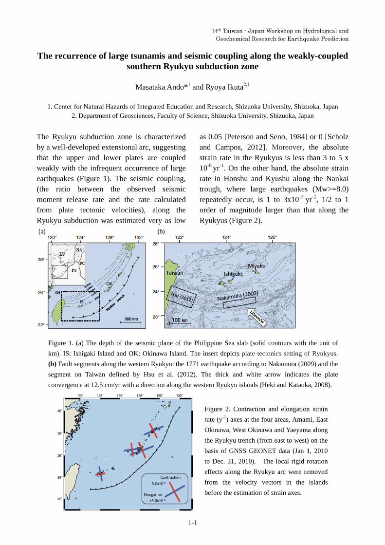
The recurrence of large tsunamis and seismic coupling along the weakly-coupled southern Ryukyu subduction zone
Masataka Ando*1 and Ryoya Ikuta2,1
1. Center for Natural Hazards of Integrated Education and Research, Shizuoka University, Shizuoka, Japan
2. Department of Geosciences, Faculty of Science, Shizuoka University, Shizuoka, Japan
The Ryukyu subduction zone is characterized by a well-developed extensional arc, suggesting that the upper and lower plates are coupled weakly with the infrequent occurrence of large earthquakes (Figure 1). The seismic coupling, (the ratio between the observed seismic moment release rate and the rate calculated from plate tectonic velocities), along the Ryukyu subduction was estimated very as low
as 0.05 [Peterson and Seno, 1984] or 0 [Scholz and Campos, 2012]. Moreover, the absolute strain rate in the Ryukyus is less than 3 to 5 x 10⁻⁸ yr-1. On the other hand, the absolute strain rate in Honshu and Kyushu along the Nankai trough, where large earthquakes (Mw>=8.0) repeatedly occur, is 1 to 3x10⁻⁷ yr-1, 1/2 to 1 order of magnitude larger than that along the Ryukyus (Figure 2).
Figure 1. (a) The depth of the seismic plane of the Philippine Sea slab (solid contours with the unit of
km). IS: Ishigaki Island and OK: Okinawa Island. The insert depicts plate tectonics setting of Ryukyus.
(b) Fault segments along the western Ryukyu: the 1771 earthquake according to Nakamura (2009) and the
segment on Taiwan defined by Hsu et al. (2012). The thick and white arrow indicates the plate
convergence at 12.5 cm/yr with a direction along the western Ryukyu islands (Heki and Kataoka, 2008).
Figure 2. Contraction and elongation strain
rate (y-1) axes at the four areas, Amami, East
Okinawa, West Okinawa and Yaeyama along
the Ryukyu trench (from east to west) on the
basis of GNSS GEONET data (Jan 1, 2010
to Dec. 31, 2010). The local rigid rotation
effects along the Ryukyu arc were removed
from the velocity vectors in the islands
before the estimation of strain axes.

14th Taiwan - Japan Workshop on Hydrological and Geochemical Research for Earthquake Prediction
1-2
Despite the extensional stress regime, a large tsunami (Mt = 8.5) struck the coasts of Ishigaki, Miyako, and surrounding islands along the western Ryukyu Trench on 24 April 1771. North of the source area of this event, we found deposits of four paleotsunamis (including the 1771 event) that occurred during the last 1,800 years on Ishigaki Island (Figure 3). Assuming that these four tsunamis were generated on a
fault along the western Ryukyu subduction zone (Nakamura, 2009), the seismic coupling ratio between the upper and lower plates can be estimated to be 25 % (Ando et al., 2015). The results of this study indicate that strain can be accumulated similarly along the other segments of the Ryukyu trench and released to generate significant tsunamis in the future.
References
Ando, M., A. Kitamura, Y. Tu, M. Nakamura, R. Ikuta, Y. Miyari, Y. Yokoyama, T. Imai, and M. Shishikura,
Recurrence interval of large tsunamis along the western Ryukyu trench, submitted to Geophys. Res. Lett.
Heki, K., and T. Kataoka (2008), On the biannually repeating slow-slip events at the Ryukyu Trench,
southwestern Japan, J. Geophys. Res., 113, B11402, doi:10.1029/2008JB005739.
Hsu, Y. J., M. Ando, S. B. Yu, and M. Simons (2012), The potential for a great earthquake along the
southernmost Ryukyu subduction zone, Geophys. Res. Lett., 39, L14302, doi:10.1029/2012GL052764.
Nakamura, M. (2009), Fault model of the 1771 Yaeyama earthquake along the Ryukyu Trench estimated from the
devastating tsunami, Geophys. Res. Lett., 36, L19307, doi:10.1029/2009GL039730.
Peterson, E. T., and Seno, T. (1984), Factors affecting seismic moment release rates in subduction zones, J.
Geophys. Res., 89, 10233-10248, doi: 10.1029/JB089iB12p10233.
Scholz, H. C., and J. Campos (2012), The seismic coupling of subduction zones revisited, J. Geophys. Res., 117,
B05310, doi: 10.1029/2011JB009003.
Figure 3. 14C dates (cal. yr
BP) of four tsunami s, T-I,
T-II, T-III and T-IV.
Radiocarbon samples were
obtained from deposits in
an excavation trench on
Ishigaki Island. The error
bars with gray circles show
reliable dates for the
articulated marine bivalves
that were transported and
buried alive by tsunamis of
T-I and T-II.

14th Taiwan - Japan Workshop on Hydrological and Geochemical Research for Earthquake Prediction
2-1
Preliminary study of GPS baseline variation and its implication to seismic activity
Tsai, Min-Chien*1
1. Seismological Center, Central Weather Bureau, Taiwan
Abstract
1. Introduction
Taiwan is situated in an active tectonic region with numerous thrust faults and
folds due to on-going collision between the Luzon arc and Chinese continental margin.
Numerous devastating earthquakes with magnitudes greater than 6 have occurred since
1900. The oblique convergence of the Eurasian and Philippine Sea Plates started at the
beginning of Late Miocene period (Ho, 1976; Barrier and Angelier, 1986; Huang et al.,
2006). The Global Positioning System (GPS) has become an efficient tool for studying
active tectonics and geodynamics (Dixon, 1991; Hager et al., 1991; Feigl et al., 1993).
Utilizing satellite positioning techniques each station can provide precise global
coordinates for its antenna position which can be used to monitor the horizontal and
vertical crustal movements at the site. There are more than 400 continuous GPS (cGPS)
stations in Taiwan area now. The dense cGPS network provide a wealth of cGPS data
for study. The present geodetic characteristics indicate the complex tectonic structure
in Taiwan area. Combining with the observed baseline variation result and seismic
activity, we hope to understand more about the possible earthquake potential area in
Taiwan.
2. Tectonic setting
The active Taiwan mountain belt results from the oblique collision between the
Luzon arc and the Chinese continental margin. The consequence of oblique collision
makes the Taiwan region exhibit all stages of the collision process from south to north:
pre-collisional rapid and distributed convergence, collision and suturing, and
post-collisional collapse and extension (Lallemend and Tsien, 1997; Shyn et al., 2005).
14th Taiwan - Japan Workshop on Hydrological and Geochemical Research for Earthquake Prediction
2-2
In the south, large anticlinal ridges and thrust faults deform the seafloors south of
Taitung and Kaoshung. Between Tainan and Kaoshung are several active north–south
trending folds and NE–SW striking right-lateral faults. In the eastern Taiwan, the
active left-lateral oblique Longitudinal Valley fault crops out along the eastern flank
of the entire valley and dips steeply beneath the Coastal Range. Major blind thrust
faults accommodate most of the shortening across the Chiayi and Miaoli area. In
contrast, two major thrust faults dominate the Taichung area. Rupture of the eastern
one, the Chelungpu fault, produced the 1999 Chi-Chi earthquake. Active structures in
the northern Taiwan accommodate extension above the Ryukyu subduction zone.
Some active fault zones on both the northwestern and southern flanks of the Ilan plain
are geomorphically evident.
3. Data collection and processing
After 1999 Chi-chi earthquake (Mw = 7.6), there were more than 150 new Cpgs
stations established, especially in Central Taiwan area. These continuous GPS stations
have been operated by various agencies, including the Central Weather Bureau
(CWB), Institute of Earth Sciences, Academia Sinica (IESAS), Central Geological
Survey (CGS) and Ministry of the Interior (MOI) since 1998. For all continuous GPS
data, we choose the time interval from 2007 to 2014 to avoid the influence of 1999
Chi-Chi earthquake. The time spans of more than half the amount of continuous GPS
sites are all larger than 4 years. All the CGPS data are processed by GAMIT/GLOBK
v.10.4 (Herring et al., 2010) with standard procedures.
4. GPS velocity field in Taiwan
Results from Global Positioning System (GPS) surveys provide key constraints to
study active tectonics and geodynamics. The converging rate across the Taiwan
arc-continent collision zone is about 80 mm/yr based on GPS measurements (Yu et al.,
1997; Yu et al., 1999; Hsu et al, 2009). Approximately half of the plate convergence is
accommodated in the fold and thrust belt of southwestern Taiwan and another half is
taken up in the Longitudinal Valley and the Coastal Range in eastern Taiwan. The
velocities in western Taiwan generally show a fan-shaped pattern, consistent with the

14th Taiwan - Japan Workshop on Hydrological and Geochemical Research for Earthquake Prediction
2-3
maximum compression tectonic stress direction. In northern Taiwan the velocity
vectors reveal clockwise rotation, indicating the on-going extensional deformation
related to the back-arc extension of the Okinawa Trough. In southern Taiwan, the
horizontal velocity increases from about 40 mm/yr in the Chia-Nan area to 55 mm/yr in
the Kao-Ping area with a counterclockwise rotation.
5. Seismicity
Taiwan is located at the plate boundary with earthquakes frequently. Plate tectonics
can be directly described by the distribution of seismic activity in space. In northern
Taiwan, most earthquakes happened along Ryukyu subduction zone where the
Philippine Sea plate northward plunge beneath of Eurasian Plate. In the contrast, the
Eurasian Plate plunge beneath of Philippine Sea plate at Pingtung area which is also
lots earthquake happened. Usually those earthquakes are with depth larger than 30 km,
most of the shallow seismic activity is on land. At western Taiwan, high seismic
activity surrounding the Peikang Basement High is prominent, lots of disastrous 7
earthquakes happened at the deformation frontal thrust zone. The eastern Taiwan, the
Longitudinal Valley is an east-dipping seismic suture zone that separates two different
tectonic regions. On the left-hand side, shallow earthquakes and normal fault-type
focal mechanism were found in the Central Range region. But on the right-hand side,
most events occurred in the Philippine Sea Plate were of the thrust-type. There are
tremors happened frequently at Hualien – Nashan area, it may worth us to discuss and
think about relationship between the tremors and large earthquakes.
6. Baseline variation
We divided Taiwan into four areas which are with numerous faults and active
seismicity. There are Hualien-Taitung area, southwestern area, Chelungpu fault zone
area, and north Taiwan area. There total 76 baselines are using in this study, some of
them are more than 50 km. In order to understand the precision of baseline data, the
formalism proposed by Savage and Prescott (1973) is utilized to describe the
precision of the epoch GPS measurements as a function of baseline length:

14th Taiwan - Japan Workshop on Hydrological and Geochemical Research for Earthquake Prediction
2-4
Where is the standard deviation, L is the baseline length, and b are constant and
length dependent source of error, respectively. The result indicates the precision is
much worse in vertical component. Therefore, the baseline estimation we only use
north and east two components. The observation of baseline from daily solution helps
us understand more and the fault activity, area tectonic structure, and possible
precursor signal. Compare the slope of baseline time series with the velocity field
obtain by time series analysis, noise analysis, and common mode error correction, the
result quite consistent. Furthermore, the baseline slope variation may give a
suggestion of local strain field is changed.
6. Summary
The dense CGPS network and active seismicity can provide us rich data to
understand more about the relationship of geodesy, seismology, and tectonic structure
in Taiwan. In this study, we separate Taiwan to 4 regions depends on tectonic setting
and seismicity, combing the geodetic data, the result shows the potential of precursor
at Hualien area. GPS time series and the baseline variation all present very different
characteristics form north to south there, and the significant periodic motion and
semi-annual periodic signal are observed in east and vertical component for the
stations on the hanging wall of Meilun Fault respectively. Consider with the adequate
data time interval and site characteristics, the Hualien area should be an index region
for precursor monitoring.
Reference
Barrier, E., and J. Angelier, 1986: Active collision in eastern Taiwan, U.S . Geol. Surv.
Open-File Report, 75, 41-58.
Dixon, T.H., 1991: An introduction to the Global Position System and some
geological applications. Rev. Geophysics, 29, 249-276.
Feigl K., D. C. Agnew, Y. Bock, D. N. Dong, A. Donnellan, B. H. Hager, T. A.
Herring, D. D. Jackson, T. H. Jordan, R. W. King, S. Larsen, K. M. Larson, M.
H. Murray, Z. K. Shen, and F. H. Webb, 1993: Space Geodetic Measurement
14th Taiwan - Japan Workshop on Hydrological and Geochemical Research for Earthquake Prediction
2-5
of Crustal Deformation in Central and Southern California, 1984-1992. J.
Geophys. Res., 98, 21677-21712. doi: 10.1029/93JB02405.
Hager, B.H., R.W. King, and M.H. Murray, 1991: Measurement of crustal
deformation using the Global Position System. Annu. Rev. Earth Planet. Sci.,
19, 351-382.
Herring, T.A., R.W. King, and S.C. McClusky, 2010: GAMIT reference manual
(Analysis at MIT) Release 10.4, Department of Earth, Atmospheric, and
Planetary Sciences, Massachussetts Institute of Technology, 182 pp.
Ho, C.S., 1976: Foothills tectonics of Taiwan, Bull. Geok. Surv. Taiwan, 25, 9-28.
Hsu, Y. J., S. B. Yu, M. Simons, L. C. Kuo, and H. Y. Chen, 2009: Interseismic crustal
deformation in the Taiwan plate boundary zone revealed by GPS observations,
seismicity, and earthquake focal mechanisms, Tectonophysics, 479, 4-18.
Huang, C. Y., P. B. Yuan, and S. J. Tsao, 2006: Temporal and spatial records of active
arc-collision in Taiwan: A synthesis. Bull Geol. Soc. Am., 118, 274-288.
Lallemend, S.E., and H.H. Tsein, 1997: An introduction to active collision in Taiwan,
Tectonphysics 274, 1-4.
Savage, J. C. and W. H. Prescott, 1973: Precision od geodelite distance measurements,
J Geophys. Res., 78, 6001-6008.
Shyn, J.H., K. Sieh, and Y.G. Chen, 2005: Tandem suturing and disarticulation of the
Taiwan orogen revealed by its neotectonic elements, Earth and Planetary
Science Letters, 233, 167-177.
Yu, S.B., H.Y. Chen, and L.C. Kuo, 1997: Velocity field of GPS stations in the Taiwan
area. Tectonophysics, 274, 41-59.
Yu, S.B., L.C. Kuo, R.S. Punongbayan and E.G. Ramos, 1999: GPS observation of
crustal motion in the Taiwan-Luzon region, Geophys. Res. Lett., 26, 923-926.

14th Taiwan - Japan Workshop on Hydrological and Geochemical Research for Earthquake Prediction
3-1
Tidal triggering of shallow very-low-frequency earthquakes in the Ryukyu Trench
Mamoru Nakamura*1 and Keito Kakazu1
1. Faculty of Science, University of the Ryukyus, Japan
Slow earthquakes, which occur around the source fault of large subduction zone earthquakes, are
occasionally triggered by tidal stress. The tidal response is affected by the high pore-pressure fluid
or change in material property in the plate interface [Ide, 2010; Royer et al., 2015].
We focus on the tidal response of shallow very-low-frequency earthquakes (VLFEs), which occur
in the shallow part of the Ryukyu Trench, and showed that the activity of VLFEs responds to ocean
tide loading and is controlled by the thickness of the subducted sediment.
We used information from the epicenter catalog, the epicenter determination procedure of which is the same as that described by Nakamura and Sunagawa [2015]. The epicenters in the catalog are determined using the arrival time of the maximum amplitude of the surface wave using a 0.02–0.05-Hz band-pass-filtered waveform of the broadband seismograms (F-net and IRIS) around the Ryukyu Trench. The period analyzed extended from January 2002 to December 2014. The minimum magnitude of the events used for the analysis was 3.4, which was determined from the magnitude–frequency relationship [Nakamura and Sunagawa, 2015]. Overall, 6595 events were used for the analysis.
First we computed Fourier analysis of VLFEs in the central and southwestern Ryukyu. If the VLFE occurred in the area, we considered a sequence of delta functions located at all hypocentral times. Next we computed the tidal sensitivity and phase lag between the occurrence of VLFEs and the ocean tide for each point, separated at intervals of 0.2°, for both the east–west and north–south directions along the Ryukyu Trench. We then predicted the fault normal stress (FNS) and updip shear stress (UDSS) and their time derivatives dFNS and dUDSS on the plate interface and compared them with the excess value (Nex) of the VLFEs [Cochran et al., 2004]. The stress components at a depth of 15 km were computed by using point-source surface loading in the homogeneous half space [Malvern, 1969]. The stress components were predicted using Earth tide strain [Matsumoto et al., 2001; Lambert et al., 2009] and ocean tide [Malvern, 1969; Matsumoto et al., 2000].
The results of computed Fourier analysis of VLFEs show that strong peaks in the spectra, corresponding to the lunar semi-diurnal tide (M2), luni-solar declinational tide (K1), and principal lunar declinational tide (O1), can be seen in central Ryukyu, whereas these peaks are obscured by background noise in southwestern Ryukyu.
The result of distribution of tidal sensitivity shows that the sensitivity and phase change gradually from northeast to southwest along the Ryukyu Trench. High sensitivity (0.20–0.42) is evident at central Ryukyu Trench, but the sensitivity is < 0.2 at southwestern Ryukyu Trench.
The Nex in the FNS ranges from 0.22 to 0.28 at central Ryukyu and from 0.04 to 0.11 at southwestern Ryukyu. The Nex in the UDSS ranges from 0.17 to 0.22 at central Ryukyu and from
14th Taiwan - Japan Workshop on Hydrological and Geochemical Research for Earthquake Prediction
3-2
0.04 to 0.11 at southwestern Ryukyu. The comparison of Nex with stress components shows that the VLFEs are activated by the
thrust-encouraging shear stress or maximum extensional normal stress of the ocean tide corresponding to the low-tide period. The tidal sensitivity is highest in the central portion of the Ryukyu Trench, where the thin sediment layer is subducting and an accretionary prism is not developed, whereas it is lowest in the southwestern portion of the Ryukyu Trench, where a thick sediment layer exists and an accretionary prism is well developed. This suggests that differences in the sediment–rock properties of the overriding plate, which cause lateral heterogeneity in the extremely high pore-fluid pressure in the plate interface, control the sensitivity of the shallow very-low-frequency earthquakes to ocean tides.
References
Cochran, E. S., J. E. Vidale, and S. Tanaka (2004), Earth tides can trigger shallow thrust fault earthquakes.
Science, 306, 1164–1166.
Ide, S. (2010) Striations, duration, migration and tidal response in deep tremor. Nature, 466, 356–359,
doi:10.1038/nature09251.
Lambert, A., H. Kao, G. Rogers, and N. Courtier (2009), Correlation of tremor activity with tidal stress in the
northern Cascadia subduction zone. J. Geophys. Res., 114, B00A08, doi:10.1029/2008JB006038.
Malvern, L. E. (1969), Introduction to the Mechanics of a Continuous Medium, 713 pp., Prentice–Hall,
Englewood Cliffs, N. J.
Matsumoto, K., T. Takanezawa, and M. Ooe (2000), Ocean tide model developed by assimilating
TOPEX/POSEIDON altimeter data into hydrodynamical model: A global model and a regional model
around Japan. J. Oceanography, 56, 576–581.
Matsumoto, K., T. Sato, T. Takanezawa, and M. Ooe (2001), GOTIC2: A Program for Computation of
Oceanic Tidal Loading Effect. J. Geod. Soc. Japan, 47, 243-248.
Nakamura, M. and N. Sunagawa (2015), Activation of very low frequency earthquakes by slow slip events in
the Ryukyu Trench. Geophys. Res. Lett., 42, doi:10.1002/2014GL062929.

14th Taiwan - Japan Workshop on Hydrological and Geochemical Research for Earthquake Prediction
4-1
Redetermination of hypocenters in and around Taiwan in early 20 century
Yuzo Ishikawa
AIST, Geological Survey of Japan, Active Fault and Earthquake Research Center
The earthquake annual reports including P wave arrival times were published by the Central Meteorological Observatory in early 20 century. These arrival times from 1907 to 1910 were inputted. The events of which P wave arrival times were more than 2 were selected for the re-determinating hypocenters. Most of the old station locations were measured by GPS using WGS84 coordinate system and some stations were estimated by Google Earth. HYPOSAT( Schweitzer,1997,2001 ) was used to determine hypocenters and the velocity structure AK135(Kennett et al.,1995) was adopted.
The biggest earthquake in this period was April 12, 1910 in the east China Sea. It was only one event of which hypocenter was determined by ISC-GEM. The second biggest was occurred on Apr. 14 1909 beneath Taipei. The hypocenter parameter was report by Utsu, but not by ISC-GEM version 2. The hypocenter parameters are shown the followed.
Utsu 1908 01 11 03:34:00(UT) 23.00 121.10 10km M6.7 This study 1908 01 11 03:35:20 25.7182 119.3747 0
Utsu 1908 07 01 07:28:00(UT) 24.00 122.00 60km M6.1
Utsu 1909 04 14 19:53:00(UT) 25.00 122.50 100km M7.2 This study 19:54 24.91 122.44 207km
This study 1909 05 23 10:43:44 25.5455 119.2412 13.9km
Fig.1 This is the sample of the seismic observation table of Meiji 42 (1907). The events occurred in May 15,
1907 were shown by events No. 663. This event most hardly shook Taipei.

14th Taiwan - Japan Workshop on Hydrological and Geochemical Research for Earthquake Prediction
4-2
This study 1909 09 29 13:49:48 23.9557 119.8888 0km This study 1909 10 03 01:38:54 23.5083 121.8552 25.6km
Utsu 1909 11 21 07:36:00 25.50 122.00 10lm M7.0 This study 07:36:19 25.0400 122.4193 14.9
Utsu 1910 01 06 19:55:00 24.00 123.00 60km M6.2 This study 19:55:35 27.2147 119.9935 72.7
This study 1910 01 12 14:49:36 23.4395 122.7930 0 This study 1910 01 20 17:27:17 24.0710 122.3640 61.6 This study 1910 02 20 14:12:47 24.9268 121.0757 0 This study 1910 03 25 18:37:27 24.0052 121.4363 2.4 This study 1910 04 02 07:22:49 23.5612 121.4732 32.6km
ISC-GEM 1910 04 12 00:22:24(UT) 25.9110 123.9730 235km M8.1 Utsu 25.00 123.00 200km M7.6 This study 25.911N 123.973E 235
This study 1910 06 17 05:28:22 23.2695 121.5620 21.3km (M6.8) This study 1910 09 01 00:44:46 22.3110 120.2097 121km This study 1910 09 01 14:21:25 24.7925 121.0880 0km This study 1910 09 01 15:22:00 25.1677 122.5067 44.2km This study 1910 11 11 09:05:41 24.7837 123.0738 40.5km This study 1910 11 14 07:34:17 23.9787 120.2048 23.7km (M7.0) This study 1910 11 29 02:26:34 22.0800 120.1702 93.6km This study 1910 12 01 21:42:17 24.0305 120.9068 50km
References
Central Meteorological Observatory, The Meiji 40 annual report of the Central Meteorological Observatory 2nd
edition Earthquake part, 62, 1913.
Central Meteorological Observatory, The Meiji 41 annual report of the Central Meteorological Observatory 2nd
edition Earthquake part, 46, 1915.
Central Meteorological Observatory, The Meiji 42 annual report of the Central Meteorological Observatory 2nd
edition Earthquake part, 78, 1917.
Central Meteorological Observatory, The Meiji 43 annual report of the Central Meteorological Observatory 2nd
edition Earthquake part, 73, 1919.
Kennett,B.L.N, Engdahl,E.R., & Buland,R. , 1995, Constraints on seismic velocities in the Earth from traveltimes.
Geophys.Res. 103,727-747.
Schweitzer, J.(1997):HYPOSAT - a new routine to locate seismic events. NORSAR Scientific Report 1-97/98,
94-102,NOSAR, Kjeller, Norway, November.
Schweitzer, J.(2001):HYPOSAT - an enhanced routine to locate seismic events. Pure and Applied Geophysics
158,227-289.

14th Taiwan - Japan Workshop on Hydrological and Geochemical Research for Earthquake Prediction
5--1
Groundwater pressure change and crustal deformation before and after the 2007 and 2014 eruptions of Mt.Ontake
Naoji Koizumi*1 ,Tsutomu Sato1, Yuichi Kitagawa1 and Tadafumi Ochi1 1.AIST, Geological Survey of Japan, Institute of Earthquake and Volcano Geology
Geological Survey of Japan, AIST started groundwater observation at the Ohtaki observatory (GOT) in 1998. GOT is about 10km southeast of the top of Mt.Ontake (Fig.1). At GOT we measure groundwater pressure in a sealed well. Since the groundwater pressure at GOT has tidal changes caused by the earth tides, we estimated the volumetric strain sensitivity of the groundwater pressure, which is 1.5-2 mm/nstrain, where the groundwater pressure is expressed as water head and "nstrain" means 10-9 strain. Since the resolution of the pressure gage at GOT is 2 mm, that of the volumetric strain converted from the groundwater pressure is 1 nstrain. The altitude of the well is about 1040m and the depth of the screen is 640 m. It means that we can observe the volumetric strain at the depth of 640 m or at the altitude of 400 m by measuring the groundwater pressure. After 1998 there were two eruptions at Mt.Ontake. One is the 2007 eruption, which occurred in March, 2007. The other is the 2014 eruption, which occurred in September 2014. A few months before the 2007 eruption, a relatively large crustal deformation, which was the gradual increase in the length of the baseline crossing Mt Ontake, was observed(Fig.2) although no such crustal deformation was observed in the 2014 eruption (Fig.3). At the 2007 eruption the groundwater pressure at GOT dropped 20 cm during almost the same period when the length of the baseline gradually increased(Fig.2) although no such groundwater pressure change was also observed(Fig.3). The 20cm drop in the groundwater pressure means 100 nstrain increase in the volumetric strain at GOT. The precursory gradual increase in the length of the baseline is converted into about 300 nstrain increase in the linear strain along the baseline. These two values are well-matched. In the presentation we will report the details of those groundwater pressure changes and the crustal deformation.
Fig.1 Distribution of the observation stations. A solid circle (GOT) is a groundwater observation station of GSJ,AIST. Four solid squares are GNSS stations of Geospatial Information Authority of
Japan(GSI). A solid triangle is a tilt observation station of Japan Meteorological Agency (JMA).

14th Taiwan - Japan Workshop on Hydrological and Geochemical Research for Earthquake Prediction
5--2
Fig.2 Observation results during the period from Jan. 2006 to Dec.2007.
Fig.3 Observation results during the period from May 2013 to April 2015. The water pressure sensor had some
trouble in August and September in 2014 and the groundwater pressure was superficially fluctuated. We
changed the sensor in October 2014.

14th Taiwan ‐ Japan Workshop on Hydrological and Geochemical Research for Earthquake Prediction
6-1
Investigation on fluid migration seismicity in association with fault zone damage: case study for 1999 M7.6 Chi-Chi, Taiwan, earthquake
Kuo-Fong Ma1, and Hidemi Tanaka2
1. Department of Earth Sciences, National Central University, Taiwan
2. Graduate School of Science, University of Tokyo, Japan
Fluid had been considered as a possible factor in triggering earthquakes, but, the
evidence in elucidating the behavior and mechanism is still unresolved. Our previous
studies in attenuation, noted as 1/ Qs, for the 1999 Chi-Chi earthquake suggest that
the fracture zone associated with fault zone could be considered as a fluid reservoir,
which possibly yield to some observations/detections of phenomena associated with
pre-, co- or post-seismic of a larger earthquake. The sudden changes in attenuation
co-seismically with decay following a diffusion process indicated possible high
pore-fluid saturation within fractured fault zone from fully to partial saturation. We
suspect this process might yield the migration of fluid flow, and thus, related to the
occurrence of some aftershocks. Aftershock sequence following a mainshock was
often considered to be related to regional tectonic stress and stress triggering of a
mainshock. For stress triggering, it refers to the seismicity in the stress increase
regime with some lapse time (>one month) for the static stress triggering. In this study,
we tried to deviate the possible fluid associated aftershocks by focusing on the stress
decrease regime and 1-3-month aftershock sequence to understand their possible
association. The migration of fluid flow increases the pore-pressure, which reduce the
normal stress, and, thus, yield the co-seismic negative Coulomb’s stress regime to
become positive to trigger these fluid flow associated aftershocks. For the study of the
Chi-Chi earthquake sequence, from the elapse time versus distance of the seismicity
in this regime suggest a fluid flow of about 220m/day. We investigate the possible
passage of fluid flow in the regime and understand its transient behavior associated
with the fault zone damage and healing process.

14th Taiwan - Japan Workshop on Hydrological and Geochemical Research for Earthquake Prediction
7-1
Monitoring of seismic velocity using ACROSS around Nojima fault rupture zone and Tokai subduction zone in Japan
Ryoya Ikuta*1, Toshiki Watanabe2, Takahiro Kunitomo3, Kin-ya Nishigami4, Koshun Yamaoka3
1. Department of Science, Shizuoka University, Japan
2. Earthquake Research Institute, University of Tokyo, Japan
3. Research Center for Seismology and Volcanology, Nagoya University
4. Disaster Prevention Research Institute, Kyoto University
This manuscript reports the recent results of seismic velocity monitoring around an active fault and a
subduction zone using artificial vibration sources named ACROSS. The ACROSS is a system designed to
monitor the temporal variation in the seismic velocity, as its name stands for Accurately Controlled,
Routinely Operated Signal System (Yamaoka et al.,2001). Now we have five ACROSS sources in Japan. One
is monitoring a fault, another is monitoring a volcano, and others are monitoring a subduction zone.
The first ACROSS was built in 1998 on southern end of the Nojima fault, which ruptured during the 1995
Kobe earthquake (M7.2), to monitor recovery of the fault strength just after the large earthquake (Fig.1). In
the initial few years of the monitoring, this Nojima ACROSS detected a strong preferred orientation of the
crack to the along-fault direction. During the experiment, sudden delays in travel times for the S wave were
observed associated with tele-seismic shakings. The S wave delay was polarized in the direction
perpendicular to the fault, which means that the S wave splitting was enhanced by the strong shakings. The
time decaying pattern of the delay suggests sudden increase and dispersion of the pore pressure.
We have conducted the monitoring using the Nojima ACROSS for 15 years to detect gradual increase of P and S wave velocity for about 0.1%. The increase corresponds to a decrease of permeability around the fault monitored by injection experiment. The seismic velocity change may be related to healing of the fault rupture zone.
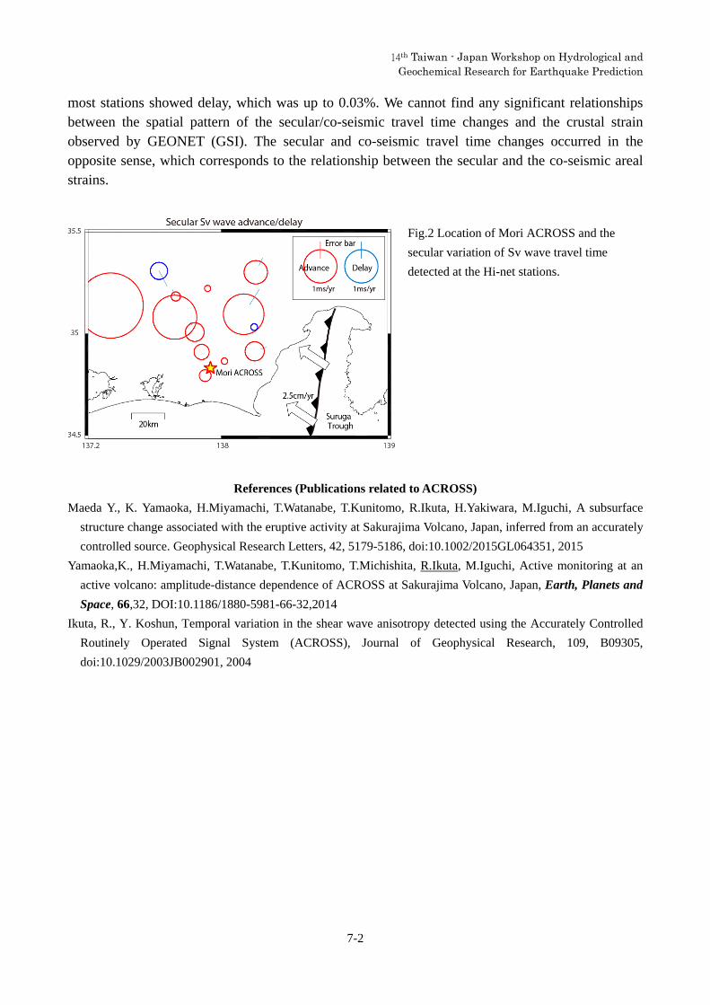
Other three ACROSS systems have been deployed in Tokai region, Japan, where the Philippine Sea plate subducts beneath Eurasian plate, to monitor the seismic velocity change associated with the plate convergence. We show the result using the source deployed in Mori (Fig.2). This Mori ACROSS started the monitoring in 2009. We analyzed the seismic velocity change using the data of 13 Hi-net stations (NIED) within 50 km from the ACROSS source. The S wave travel time showed gradual advance at the most stations, which was up to 0.01%/yr. Associated with the 2011 Tohoku Oki earthquake, the travel time of S waves at the
Figure 1. Location of the ACROSS vibrators
(open star) and the seismometers. The solid
triangles denote the 1700-m and the
800-m-deep boreholes. The enlarged map at
the bottom right shows the configuration of the
observation system. The thick gray lines are
traces of the 1700-m and the 800-m-deep
boreholes. The open circles denote
borehole-type seismometers.
14th Taiwan - Japan Workshop on Hydrological and Geochemical Research for Earthquake Prediction
7-2
most stations showed delay, which was up to 0.03%. We cannot find any significant relationships between the spatial pattern of the secular/co-seismic travel time changes and the crustal strain observed by GEONET (GSI). The secular and co-seismic travel time changes occurred in the opposite sense, which corresponds to the relationship between the secular and the co-seismic areal strains.
References (Publications related to ACROSS)
Maeda Y., K. Yamaoka, H.Miyamachi, T.Watanabe, T.Kunitomo, R.Ikuta, H.Yakiwara, M.Iguchi, A subsurface
structure change associated with the eruptive activity at Sakurajima Volcano, Japan, inferred from an accurately
controlled source. Geophysical Research Letters, 42, 5179-5186, doi:10.1002/2015GL064351, 2015
Yamaoka,K., H.Miyamachi, T.Watanabe, T.Kunitomo, T.Michishita, R.Ikuta, M.Iguchi, Active monitoring at an
active volcano: amplitude-distance dependence of ACROSS at Sakurajima Volcano, Japan, Earth, Planets and
Space, 66,32, DOI:10.1186/1880-5981-66-32,2014
Ikuta, R., Y. Koshun, Temporal variation in the shear wave anisotropy detected using the Accurately Controlled
Routinely Operated Signal System (ACROSS), Journal of Geophysical Research, 109, B09305,
doi:10.1029/2003JB002901, 2004
Fig.2 Location of Mori ACROSS and the
secular variation of Sv wave travel time
detected at the Hi-net stations.

14th Taiwan - Japan Workshop on Hydrological and Geochemical Research for Earthquake Prediction
8-1
Regional variation of CH4 and N2 production processes in deep
aquifers associated with the accretionary prism in Southwest Japan
Hiroyuki Kimura, Makoto Matsushita, Shugo Ishikawa
Department of Geosciences, Graduate School of Science, Shizuoka University, 836 Oya,
Suruga-ku, Shizuoka 422-8529, Japan.
An accretionary prism is composed mainly of ancient marine sediment scraped
from a subducting oceanic plate at a convergent plate boundary. Large amounts of
anaerobic groundwater and natural gas, mainly methane (CH4) and nitrogen (N2), are
present in the deep aquifers associated with an accretionary prism, but the origins of
these gases are poorly understood.
Our present study revealed a regional variation in the CH4 and N2 production
processes in the deep aquifers of the accretionary prism in Southwest Japan known as
the Shimanto Belt. Stable carbon isotopic and microbiological analyses revealed that the
CH4 is produced through nonbiological thermal decomposition of organic matter in the
deep aquifer of the coastal area near the convergent plate boundary, whereas a
syntrophic consortium of hydrogen (H2)-producing fermentative bacteria and H2-using
methanogens contributes to the significant CH4 production observed in the deep
aquifers of the middle and mountainous areas associated with the accretionary prism.
Our results also suggest that N2 production through the anaerobic oxidation of organic
matter by denitrifying bacteria occurs particularly in the deep aquifer of the
mountainous area in which the groundwater is affected by rainfall.
Overall, our results lead us to the conclusion that dynamic groundwater flow and
the ongoing biodegradation of organic matter in the ancient sediments contribute to the
CH4 and N2 reserves in the deep aquifers associated with the accretionary prism in
Southwest Japan.
14th Taiwan - Japan Workshop on Hydrological and Geochemical Research for Earthquake Prediction
9-1
Earthquake Precursory Studies Using Continuous Soil Gas Monitoring Data in Taiwan: An Overview
Vivek Walia1*, Ching-Chou Fu2,3, Tsanyao Frank Yang2#, Arvind.Kumar1,
Shih-Jung Lin1, Cheng-Hong Chen2 and Kuo-Liang Wen1,4
1 National Center for Research on Earthquake Engineering, National Applied Research
Laboratories, Taipei, Taiwan ([email protected], [email protected]) 2 Department of Geosciences, National Taiwan University, Taipei-106, Taiwan 3 Institute of Earth Sciences, Academia Sinica, Taipei 115, Taiwan 4 Department of Earth Sciences and Institute of Geophysics, National Central University,
Jhongli, Taiwan
The island of Taiwan is a product of the collision between Philippine Sea plate and
Eurasian plate which makes it a region of high seismicity. Active subduction zones occur
south and east of Taiwan. After the destructive Chi-chi earthquake (MW = 7.6, Sept. 21,
1999) an accelerated phase of geochemical monitoring started in Taiwan. Measurement
of soil-gas emissions along active zones is characterized as a geochemical tool to identify
and monitor tectonic activity in the region. Geochemical variations of soil-gas
composition in the vicinity of the geologic fault zone of Northeastern and Southwestern
parts of Taiwan have been studied in detail recently. To carry out the investigations,
variations in soil-gases compositions were measured at continuous earthquake monitoring
stations along different fault zones in regions under the study. Before selecting a
monitoring site, the occurrence of deeper gas emanation was investigated by the soil-gas
surveys which is followed by continuous monitoring of some selected sites with respect
to tectonic activity to check the sensitivity of the sites. Based on the results of long term
geochemical monitoring at the established monitoring stations we can divide the studied
area in two different tectonic zones. We proposed tectonic based model for earthquake
forecasting in Taiwan and tested it for some big earthquakes occurred during the
observation period. Based on the anomalous signatures from particular monitoring
stations we are in a state to identify the area for impending earthquakes of magnitude ≥ 5
and we have tested it for some earthquakes which rocked the country during that period. It
can be concluded from the study that the stress/strain transmission for a particular
earthquake is hindered by different tectonic settings of the region under study. The stress-

14th Taiwan - Japan Workshop on Hydrological and Geochemical Research for Earthquake Prediction
9-2
induced variations due to impending earthquakes in soil-gas are contaminated by
meteorological changes and, hence, assessment and quantification of these influences are a
major prerequisite in the isolation of precursory signals. An effort has been made to reduce
the noise level, which may be due to meteorological parameters by using different
statistical filters. In an effort to reduce the response time and increase the efficiency, the
automatic operating methodology was adopted to process the data from the monitoring
stations. The data from the monitoring stations were automatically uploaded to the web
service which provides the data management/exhibition with less response time database. In
addition to monitoring station data, seismic parameters (i.e. Magnitude/location/depth of
the event, the intensity/epicentral distance at a monitoring station, etc.) and meteorological
parameter data are also uploaded from Central Weather Bureau of Taiwan
(www.cwb.gov.tw) simultaneously. It would be helpful in increasing efficiency of
earthquake prediction studies. #This Abstract and Talk will be dedicated to Late Profosser Tsanyao Frank Yang (1961-2015)
14th Taiwan - Japan Workshop on Hydrological and Geochemical Research for Earthquake Prediction
10-1
Radon concentration distributions of deep groundwater around Tachikawa fault
Fumiaki Tsunomori 1,* and Tomoya Shimodate 2
1 The University of Tokyo, 7-3-1 Hongo, Bunkyo, Tokyo 113-0033, Japan
2 International Christian University, 3-10-2 Osawa, Mitaka, Tokyo 181-8585, Japan
Distribution of groundwater radon concentration around the Tachikawa fault was surveyed. A
mean radon concentration of the shallow groundwater was similar to the value that was reported by
Saito in 1993. A contrast of the radon distribution on both sides of the Tachikawa fault slightly
changed in comparison to that reported by Saito. According to the Tokyo Statistical Yearbook, the
Musashino plateau in the northeast of the Tachikawa fault was developed for residential zone from
farmland. This urbanization might suppress the recharge of meteoric water into shallow aquifers. A
mean radon concentration of the deep groundwater was comparable with the value of the shallow
groundwater. This supports that the geology around the Tachikawa fault consists of sediment rocks
that was supplied from the mountain area of Tokyo without hypogene rocks. However, except a few
sampling points, the radon concentrations of deep groundwater along the Tachikawa fault were
significantly higher than that of groundwater from an aquifer contained in a bedrock. It is presumed
that this distribution arises from the development of a fault fracture zone around the Tachikawa
fault.
14th Taiwan - Japan Workshop on Hydrological and Geochemical Research for Earthquake Prediction
11-1
Anomalous decrease in groundwater radon and dissolved-gases before the Taiwan and Japan earthquakes
T. Kuo 1 and F. Tsunomori 2
1Department of Mineral and Petroleum Engineering, National Cheng Kung University, Tainan, Taiwan 2Laboratory of Earthquake Chemistry, Faculty of Science, The University of Tokyo, Tokyo, Japan
Recurrent groundwater radon anomalous declines were observed at well D1 in the
Antung hot spring in eastern Taiwan prior to the four major earthquakes – (1) 2003
Mw 6.8 Chengkung, (2) 2006 Mw 6.1 Taitung, (3) 2008 Mw 5.4 Antung, and (4) 2011
Mw 5.0 Chimei. The epicenters are located 24 km, 52 km, 13 km, and 32 km,
respectively, from well D1. Similarly, an anomalous decrease in radon concentration
was observed in groundwater at well SKE-1 near Nakaizu in Japan prior to the 1978
Izu-Oshima-Kinkai earthquake of magnitude M 7.0. The epicenter is located 25 km
from well SKE-1. Radon volatilization into the gas phase can explain the anomalous
decrease of radon precursory to the above earthquakes.
Simultaneous concentration declines in groundwater-dissolved radon and methane
were observed prior to the 2008 Mw 5.4 Antung earthquake. Concurrent
concentration declines in groundwater radon, methane, and ethane were also observed
prior to the 2011 Mw 5.0 Chimei earthquake. Similarly, an anomalous decrease in
methane concentration was observed at Byakko spring prior to the 1984 western
Nagano Prefecture earthquake of magnitude M 6.8. The epicenter is located 50 km
from Byakko spring. The above observations in Taiwan and Japan also suggest that
radon due to its stable background is the best-choice tracer among the
groundwater-dissolved gases for strain changes in the crust preceding an earthquake.
14th Taiwan - Japan Workshop on Hydrological and Geochemical Research for Earthquake Prediction
12-1
Change of Rock Permeability Induced by the 2011 Tohoku Earthquake
Chihiro Kinoshita*1 ,Yasuyuki Kano1, Naoji Koizumi2 and Hisao Ito
1. Research Center for Earthquake Prediction, Disaster Prevention Research Institute, Kyoto University, Japan 2. AIST, Geological Survey of Japan, Active Fault and Earthquake Research Center
We have been monitoring the pressure of groundwater at the Kamioka mine in Gifu prefecture, central Japan. Kinoshita et al. (2015) observed a large pressure decrease which is equivalent to over 2 m change in water level after the 2011 Tohoku earthquake(M9.0), although the hypocentral distance is more than 500 km.
Kinoshita et al. (2015) hypothesized that new water paths were made associated with the shaking from the earthquake and the rock mass became more permeable, because the pressure decreases continued for several days. To verify the hypothesis, we calculated the hydraulic diffusivity from the response of the pressure to Earth tides. Earth tides induce expansion and contraction of the crust, and pore pressure responses to this deformation. The pressure change from theoretical strain changes of the Earth tides can be calculated and subtracted from the observed pore pressure data. Then, we can extract the hydrological rocks property from the residual pore pressure. We used the tidal analysis program BAYTAP-G (Tamura et al., 1991) to calculate the Earth tide response and focused on the M2 and O1 constituents which are the largest. The M2 and O1 amplitudes decreased after the Tohoku earthquake. We estimated the hydraulic diffusivity from those results and showed there was remarkable increase after the earthquake. To try to understand the cause of the permeability change, we compared the effects of both static and dynamic strain associated with the earthquake, but there is no clear difference. Kinoshita et al. (2015) could not conclude from those results whether static or dynamic strain has a dominant effect.
The Geological Survey of Japan, AIST has developed a network of groundwater monitoring in Japan since 1976 (Itaba et al., 2008). We investigated the groundwater levels and pressure changes before and after the Tohoku earthquake using the AIST boreholes. Among the factors influencing groundwater changes, at first, we focus on the effect of differences in boreholes lengths. Each observation site of AIST used for the present analysis has two or three boreholes with different lengths. We investigated the groundwater responses of each borehole and depth in terms of confined and unconfined aquifers.
References
Tamura, Y., T. Sato, M. Ooe and M. Ishiguro, A procedure for tidal analysis with a Bayesian information criterion,
Geophys. J. Int., 104, 507–516, 1991.
Kinoshita, C., Y. Kano and H. Ito, Shallow crustal permeability enhancement in central Japan due to the 2011
Tohoku earthquake, Geophys. Res. Lett., 42, 773-780, 2015.

14th Taiwan - Japan Workshop on Hydrological and Geochemical Research for Earthquake Prediction
13-1
Temporal changes of earthquake-related groundwater-level
Ching-Yi Liu1, Yeeping Chia1, Yen-Chun Kuan2, Kai-Wen Kuo3 1 Department of Geosciences, National Taiwan University, Taipei, Taiwan, R.O.C.
2 Water Resources Agency, Ministry of Economic Affairs, R.O.C. 3 Central Weather Bureau, Ministry of Transportation and Communications, R.O.C.
Taiwan is located at the boundary between the Eurasian plate and the Philippine
Sea plate, which is in the tectonic active region where earthquakes occur frequently.
Changes in groundwater-level induced by earthquakes have been recorded in many
monitoring wells installed in the plain area of the island. From groundwater level
record, there are two types of co-seismic groundwater level changes, one is oscillatory
change and the other one is sustained change. Sustained groundwater-level changes
during earthquakes are often observed in the confined aquifer, whereas accompany
oscillatory changes could only be recorded by high-frequency data logger. In this
study, we analyzed long-term monitoring data at two single wells, one is Pingding
(PD) and the other is Liujar (LJ). PD well is located at the top of the northern tip of
Douliu Hills, groundwater-level is monitored in 1-hour interval, and temporal changes
recorded mostly co-seismic rises. LJ well is located west of the foot of the Western
Foothills, recorded with 1-Hz monitoring data, and temporal co-seismic changes are
falls. From the results of the two wells, it is speculated that co-seismic change
reflect the hydrogeological condition of aquifer or the redistribution of crustal strain,
and indicate the local stress field changes over time.
Keywords: temporal change, groundwater level, co-seismic

14th Taiwan - Japan Workshop on Hydrological and
Geochemical Research for Earthquake Prediction
14-1
Ascension of Fluid from Mud Volcanoes Distributed along Anticline and Fault Zones
Keiji Asano1, Kazuhiro Tanaka1, Koichi Suzuki2,
Lai Wen-Chi3 , Nariaki Nishiyama1 1Graduate School of Science and Engineering, Yamaguchi University, Yamaguchi, Japan 2Geosphere Science Sector, Civil Engineering Research Laboratory, Central Research Institute of
Electric Power Industry, Abiko, Chiba, Japan 3Disaster Prevention Research Center, National Cheng Kung University, Taiwan City, Taiwan
Mud volcanoes, which are often distributed in oil and gas fields, are conical mounds that consist of
mud and breccia. The material ejected from mud volcanoes ascends from deep underground and is
expelled by abnormal water pressure. Mud volcanoes have heights ranging from a few meters to tens of
meter up to 500 m. Because natural disasters caused by mud volcanism are a concern, the
spatiotemporal activity of mud volcano should be evaluated when selecting the site of underground
facilities such as geological disposal facilities for high-level radioactive waste. Active inland mud
volcanoes are distributed in southwest Taiwan and are situated along the axes of anticlines and faults
(Hamada et al., 2009). The controlled source audio-frequency magnetotelluric method (CSAMT) has
been used to determine the distribution of low-resistivity zones in Niigata Prefecture, Japan, and
showed that mud volcanoes along an anticline axis have underground mud chambers.
Here, we conducted geological surveys and geochemical analyses of groundwater and gas expelled
from mud volcanoes distributed along the Chishan fault and along the Gudingkeng anticline axis in
southwest Taiwan. Also, we performed geophysical exploration by the CSAMT method around the
Wushanding mud volcanoes distributed along the Chishan fault to identify underground structures and
the paths of fluid ascending from deep underground. As a result, we found that the expelled fluid
ascends from a shallower depth for mud volcanoes distributed along the anticline axis than for those
distributed along the fault. In the case of the anticline axis, the fluid is stored near the ground surface in
mud chambers under the mud volcanoes. Gas pressure increases by degassing in the shallow
underground mud chambers and many cracks are generated in the impermeable cap rock. The cap rock
then breaks and fluid erupts to the ground surface for some period, forming the caldera structure. On
the other hand, the fluid expelled from mud volcanoes distributed along the fault ascends through the
fault, and some of the fluid is expelled directly from the fault and some migrates to the anticline axis,
where it is trapped temporarily under the cap rock before ascending to the surface without intense
activity.
14th Taiwan - Japan Workshop on Hydrological and Geochemical Research for Earthquake Prediction
15-1
The Mechanism of the Pre-seismic Changes of the Tidal Deviation of Groundwater Level in Hualien City, Taiwan
Wen-Chi Lai1, Shih-Jung Wang2, Kuo-Chon Hsu3 and Chjeng-Lun Shieh1
1. Disaster Prevention Research Center, National Cheng Kung University, Taiwan 2. Georesources Research Center, National Cheng Kung University, Tainan, Taiwan
3. Department of Resources Engineering, National Cheng Kung University, Taiwan
The different response by various natural stimuli and processes (tidal force, barometric loading, ground shaking and crustal strain) were used as the elements of the hydraulic information in the earthquake induced groundwater level changes. Using the ocean tidal force to act as naturally recurring stimuli to provide a sufficiently varied distribution of excitations in time and space, and represented the hydro-geological changes responses to the earthquake processes. The purposes of this study are to analyze the recently observation results of the earthquake induced tidal deviation of groundwater level in observation wells around Hualien city, eastern Taiwan. The analysis of the tidal responses and the atmospheric pressure responses also will be used to estimate the mechanical properties of the aquifer. Comparison the observation between the sea level and the groundwater level changes in the each event, offers the opportunity to discussion the possible mechanism of the hydrologic response to earthquake. Curiously pre-seismic groundwater level changes in the pattern of tidal deviation occurred repeatedly in several local seismic events nearby the Hualien City. Poroelastic model been used to act as the simulation tool to fit to the pre-seismic groundwater level changes. The results shows groundwater preseismic change could be simulated by a recharge or discharge at a fault zone with poroelastic model. The numerical results could support our conceptual model with a permeable fault zone between sea loading and groundwater responses. Our numerical model provides some information for the preseismic mechanism but more investigations are required.
References
Naoji Koizumi, Norio Matsumoto, Wen-Chi Lai, Mamoru Nakamura., Hydrological and geochemical cooperative
research for earthquake forecasting in Taiwan. Japan Geoscience Union Meeting, 2013.
Wen-Chi Lai, Kuo-Chin Hsu, Chjeng-Lun Shieh, Youe-Ping Lee, Kuo-Chang Chung, Naoji Koizumi and Norio
Matsumoto., Evaluation of the effects of ground shaking and static volumetric strain change on earthquake
related groundwater level changes in Taiwan. Earth, Planets and Space, Vol. 62,No. 4,p. 391-400, 2010.
Wen-Chi Lai,Chjeng-Lun Shieh, Norio Matsumoto , Naoji Koizumi., The Observation of the Tidal Deviation of
Groundwater Level Act as the Precursory Changes of Earthquakes, Proceedings of the 10th Taiwan-Japan
International Workshop on Hydrological and Geochemical Research for Earthquake Prediction, 2012.
Wen-Chi Lai, Shih-Jung Wang, Naoji Koizumi and Norio Matsumoto., The Mechanism of the Pre-seismic
Changes of the Tidal Deviation of Groundwater Level in Hualien City, Taiwan. Asia Oceania Geosciences
Society (AOGS) 10th Annual Meeting, Brisbane, Australia. 2013.