seis and eea sdi stefan jensen - head of group seis and data centre services geoforum 18.5.2010
TRANSCRIPT
SEIS and EEA SDIStefan Jensen - head of group SEIS and data centre servicesGeoForum 18.5.2010
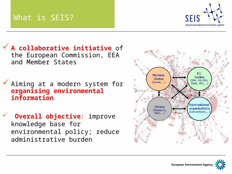
What is SEIS?
A collaborative initiative of the European Commission, EEA and Member States
Aiming at a modern system for organising environmental information
Overall objective: improve knowledge base for environmental policy; reduce administrative burden

Where SEIS is about...
• Sharing (organisation)- Political commitment (legislation) - Partnership (win-win)- Networking (connecting)
• Environmental Information (content)- Horizontal integration (e.g. data centres)- Vertical integration (local to global)- Online access - real time- For policy makers and public
• System (infrastructure and services)- Existing ICT Infrastructure- Inspire, Reportnet, GMES,...- New e-Services (e-Government)

Fragmented reporting systems
Shortcomings in relation to timeliness, availability, reliability, relevance of information
Shortcomings in ability to turn data into policy-relevant information
Underexploited opportunities offered by modern technologies
Many initiatives and processes in the right direction, but inadequate co-ordination
International Conventions and EU environmental legislation: main drive for collection of environmental data
A wealth of information is collected but:
EuroStat EC EEA OECD UNEP
ETC
DG
DG
National institutions
Users
UNECEWHO...
Why SEIS is needed

Why SEIS is needed … continued
• International Conventions and EU Environment legislation: main drive for collection of environmental data.
• A wealth of information is collected but:• Significant gaps remain• Fragmented reporting systems • Shortcomings in relation to timeliness, availability,
reliability, relevance of information• Shortcomings in ability to turn data into policy-relevant
information• Underexploited opportunities offered by modern
technologies• Many initiatives and processes in the right direction, but
inadequate co-ordination

Live Information SystemsThe current data flows
Member states Organisations Member states Organisations
MS
MS
MS
MS
MS
EEA
OECD
UNEP
Data reporting
Data reporting
Data reporting
Data reporting
Data reporting
MS
MS
MS
MS
MS
EEA
OECD
UNEP
SEIS vision From Reporting to Online ServicesSEIS visionFrom reporting to online information services
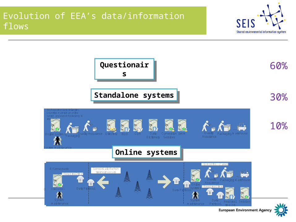
Evolution of EEA’s data/information flows
Quality Assurance
Warehouse
National Reporting / Reportnet International
OperatorFilling Questionairs Forms
1) Reportnet questionnaires.Countries fill forms directly into reportnet
PackagingCDRDirectory ROD Data Dictionary
ConversionServices
DMM
60%
10%
30%Packaging Quality
AssuranceWarehouse
National Reporting / Reportnet International
PackagingOffline systems CDRDirectory ROD Data Dictionary
ConversionServices
DMMQuality Assurance
2) Reportnet data deliveries.Countries maintain an offline application and export for delivery in reportnet
PackagingQuality Assurance Quality
AssuranceWarehousePackaging
3a) Reportnet data deliveries.Countries maintain an online systen and export for delivery in reportnet
Online systems CDRDirectory ROD Data Dictionary
ConversionServices
DMM
System maintanance
Online systems
3b) Delivery happens near real time. Both systems are monitored. (SEIS)
Online systems
Quality Assurance
WarehousePackagingData flow consortium
System maintanance
System maintanance
Data Protocol
Conceptial data flow model
Data Protocol
Data Protocol
Near real time DB
Services
~Near real time
~6 months - 2 year
~Near real time
Online systems
4) Sensor web
Online systems
Quality Assurance
WarehousePackaging
System maintanance
System maintanance
Data Protocol Data Protocol
Data Protocol
Near real time DB
Services
~Near real time
~6 months - 2 year
~Near real time
Sensors alert when treshold occurs
QuestionairsQuestionairs
Standalone systemsStandalone systems
Online systemsOnline systems

10 European data centresEnvironmental data centres SEIS elements on the EU level
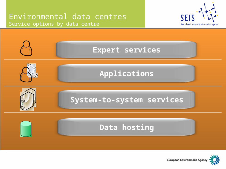
Expert services
Applications
System-to-system services
Data hosting
European data centre functionsEnvironmental data centres Service options by data centre

What is a Spatial Data Infrastructure
" A framework of technologies, policies, standards, and human resources necessary to acquire, process, store, distribute, and improve the use of geospatial data across multiple public and private organizations."
1. Partnerships, policies, agreements 2. Data3. Standards4. Network services
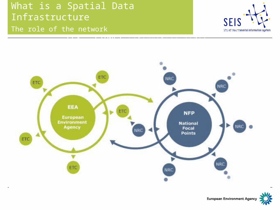
European Spatial Data InfrastructureEEA - EIONET information nodes
What is a Spatial Data InfrastructureThe role of the network

Vision and Principles
• Data should be collected once and maintained at the level where this can be done most effectively
• It should be possible to combine seamlessly spatial data from different sources and share it between many users and applications
• Spatial data should be collected at one level of government and shared between all levels
• Spatial data needed for good governance should be available on conditions that are not restricting its extensive use
• It should be easy to discover which spatial data is available, to evaluate its fitness for purpose and to know which conditions apply for its use
SDI components
1. Policies and partnerships
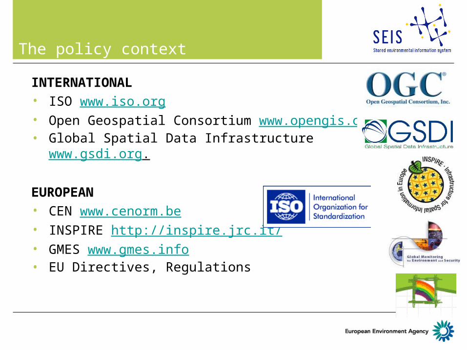
The policy context
INTERNATIONAL• ISO www.iso.org• Open Geospatial Consortium www.opengis.org.• Global Spatial Data Infrastructure www.gsdi.org.
EUROPEAN• CEN www.cenorm.be • INSPIRE http://inspire.jrc.it/ • GMES www.gmes.info • EU Directives, Regulations

SDI components
2. Data

Annex I
1. Coordinate reference systems
2. Geographical grid systems
3. Geographical names
4. Administrative units
5. Addresses6. Cadastral parcels7. Transport networks8. Hydrography9. Protected sites
Annex II
1. Elevation2. Land cover3. Ortho-imagery4. Geology
INSPIRE Thematic Scope
Annex III
1. Statistical units2. Buildings3. Soil4. Land use5. Human health and
safety6. Utility and
governmental services
7. Environmental monitoring facilities
8. Production and industrial facilities
9. Agricultural and aquaculture facilities
10.Population distribution – demography
11. Area management/ restriction/regulation zones & reporting units
12. Natural risk zones13. Atmospheric
conditions14. Meteorological
geographical features
15. Oceanographic geographical features
16. Sea regions17. Bio-geographical
regions18. Habitats and
biotopes19. Species distribution20. Energy Resources21. Mineral resources

EEA SDI core data 2006
Needs AMP2006 for core geospatial dataset
Present data source used by EEA
INSPIRE Annex I
data
INSPIRE Annex II
data
INSPIRE Annex III
data
Administrative units EuroBoundaryMap Transport networks TeleAtlas Standard European reference grid EEA Geographical names EuroGlobalMap Rivers EGM River catchments CCM Protected sites CDDA Coastline Eurosion/IMAGE2000 Lakes CLC/EGM Ortho-imagery IMAGE2000 Elevation and bathymetry SRTM Land cover CLC Geology IGME 5000 Analytical units (zones) EEA Soil map of Europe JRC Population distribution EEA/JRC IMAGE2000 Settlements EUROSTAT
Wa
ter
Air
Cli
ma
te C
ha
ng
e
La
nd
Us
e
Na
ture
B
iod
ive
rsit
y

Inspire Annex I,II and III data related to Eionet data flow
EIONET themes (bold = EEA lead data centre) ANNEX I ANNEX II ANNEX IIIAgriculture x xAir Emissions xAir Quality xChemicals xClimate Change xCommunication and Translation xEnergy xFisheries xGroundwater x xHealth and Environment xInformation Systems x x xMarine and Coastal Environment x xNature Protection and Biodiversity x x xNoise xPolicy Instruments and EvaluationResource Use xRivers and Lakes x xState of Environment Reporting x x xSoil xSpatial Analysis and Land Cover x x xTransport xWaste xWater Emissions xWater Quantity and Use x x
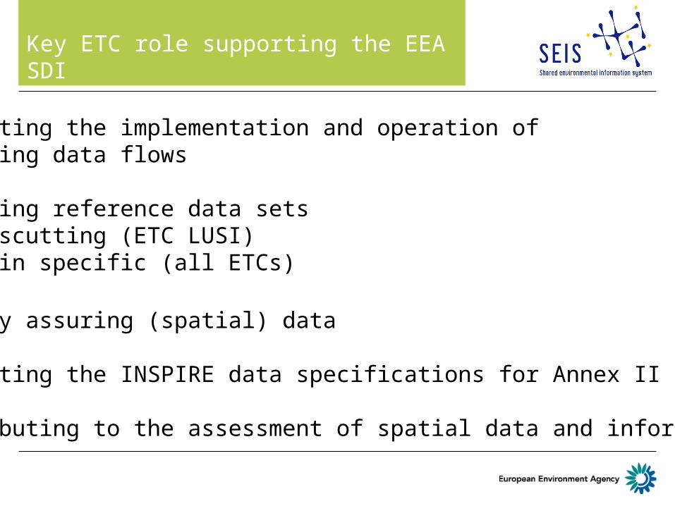
Key ETC role supporting the EEA SDI
Supporting the implementation and operation of reporting data flows
Preparing reference data sets - Crosscutting (ETC LUSI)- Domain specific (all ETCs)
Quality assuring (spatial) data
Supporting the INSPIRE data specifications for Annex II and III
Contributing to the assessment of spatial data and information

SDI components
3. Standards and interoperability

OpenGIS® specifications
• More

Standards and interoperabilityRelevant areas
• Catalogues • Metadata (ISO19115, INSPIRE)• Geo-referencing system (ETRS89)• Gazetteers• Data transfer (XML, GeoRSS, RSS)• Software and services (WMS, others)• Semantic issues (eGov, RDF, GEMET …)• Data quality

EEA services based on OGC standards
Available services around
CLC 1996CLC 2000Natura 2000
In preparation
CLC2006WISE RBD
at http://discomap.eea.europa.eu/arcgis/rest/services

Example EEA service built on that

Spatial data quality elements
1. Completeness:”Presence and absence of features, their attributes and relæationships”
2. Logical consistency:”Degree of adherence to logical rules of datastructure, attribution and
relations”3. Position accuracy:
”Accuracy of the position of features”4. Temporal accuracy:
”Accuracy of the temporal attributes and temporal relationships of features”
5. Thematic accuracy:”Accuracy of quantitative attributes and the correctness of non-
quantitative attributes and of the classifications of features and their relationships”

SDI components
4. Network services

EEA/Eionet SDI services

Other network / SDI related services
EEA map viewers
Ozone Web
WISE distributed architecture – reporting pilot
ePRTR (later in 2009)
EyeonEarth v2 (Water and Airwatch) (Nov. 2009)
Natura 2000 GIS viewer (later in 2009)
... INSPIRE network services still to be built... INSPIRE network services still to be built

WISE principles are SEIS principles
• Cooperation of EU institutions and Member States• Information is managed as close as possible to its source ----
Distributed WISE nodes• Information is provided once and used for many purposes
As of 2007 Reportnet is the WFD reporting tool
• Information accessible for clients to make comparisons at the appropriate geographical scale and information available to the public after due consideration of the appropriate level of aggregation, - (WISE map viewer displays of countries, river basins, catchment areas)
• European funding mechanisms should focus on delivering cost-effective analytical tools and services e.g. HarmoiCA (http://www.wise-rtd.info.)

INSPIRE compliant distributed network architecture I

SEIS in practice at EEA (II)

SEIS in practice at EEA (III)

Conclusions
SEIS implementation on EU level along data centre developement
Main ETC role in supporting SDI data related topics
EEA SDI stepwise rolled out
THANK YOU!