sedimentology and paleogeography of upper …. croix/salt_river184.pdf37 sedimentology and...
TRANSCRIPT

Sedimentology and Paleogeography of Upper Cretaceous Rocks, St. Croix, U.S. Virgin Islands: New
Interpretations
Daniel Stanley
Division of Sedimentology Smithsonian Institution
Washington, D.C. 20560
Converted to digital format by Thomas F. Barry (NOAA/RSMAS) in 2004. Copy available at the NOAA Miami Regional Library. Minor editorial changes may have been made.
37
Sedimentology and Paleogeography of Upper Cretaceous Rocks, St. Croix, U.S. Virgin Islands: New Interpretations
Daniel Jean Stanley Division of Sedimentology Smithsonian Institution Washington, D.C. 20560
ABSTRACT
A purely turbidite or gravity-emplaced interpretation does not adequately explain the origin of marine volcaniclastic strata in Upper Cretaceous units on St. Croix, U.S. Virgin Islands. Most sandy layers, termed intermediate variants, record emplacement in two stages: first by turbidity currents flowing toward the south, and then subsequent reworking of these layers by bottom currents flowing toward the west. Thus sands accumulating on lower-slope aprons were displaced along bathymetric contours before ultimate burial. A natural continuum results between downslope-directed turbidity current and bottom current-tractive (contourite) "end-member" deposits. The lower part of a variant layer typically preserves the original, graded basal (A) turbidite division, while the texturally cleaner middle and upper parts usually show structures more typically associated with tractive transport. Westerly-directed deep-ocean current flow in the northeastern part of the Caribbean during the Late Cretaceous was parallel to the surface circulation in this region. This flow was probably driven by thermohaline processes. At the end of the Cretaceous, the paleo-Atlantic was still narrow and the Caribbean configuration was considerably different than at present. Current-reworked turbidites and bioturbation structures, however, provide clear evidence of active deep-water circulation in a tectonically active island-arc setting, and maintenance of oxygenated conditions on the sea floor.
turbidites (Whetten, 1966; Speed, 1974). Recent inventories of sedimentary and biogenic structures of the Caledonia Formation and associated volcaniclastic and tuffaceous units indicate a considerably more complex depositional origin (Stanley, 1987).
In studies of deep-sea deposits undertaken during the past two decades there has been much emphasis placed on contrasting graded turbidite and ripple-laminated contourite facies. A problem remains, however, in that strata in some marine settings (cf. Stanley and Taylor, 1977) are neither of distinct turbidite origin nor emplaced entirely by deep-sea bottom currents (Fig. 2). Recent work has shown that suites of sedimentary structures and textures displayed by transitional sandy facies in modem ocean settings provide some important clues to interpret their origin (Stanley, 1987). This paper focuses on marine sandy layers of Cretaceous age in St. Croix which include turbidites and contourites, as well as variants of both turbidites and strata reworked by bottom currents. The present summary highlights concepts and examples from several recently published articles (Stanley, 1987, 1988a, 1988b).
Early key studies indicating that turbidites can be reworked by deep bottom currents were published by Heezen and Hollister (1964), Hubert (1964) and Hsu (1964). Assemblages of petrologic characteristics of sandy and silty strata typically associated with turbidites (cf. Bouma, 1962; Walker, 1965; Kuenen and Humbert, 1969) can be contrasted with sandy facies emplaced by deep bottom currents (cf. Heezen and Hollister, 1971; Hollister and Heezen, 1972; Bouma and Hollister, 1973; Unrug, 1977, 1980; Piper, 1978; Shanmugan and Walker, 1978; Stow and Lovell, 1979; Stow and Shanmugan, 1980; and Lovell and Stow, 1981). Interpretations of depositional processes from deep-sea sands, however, have remained oversimplified, and the suite of existing sediment types in deep-marine settings is certainly more extensive than has been described.
INTRODUCTION
St. Croix, largest of the Virgin islands, and Buck
Island, located 2.5 km to the north, are underlain by terrigenous and volcanigenic sequences of Late Cretaceous age. Cretaceous sections are exposed in the hilly eastern half of the island, and also in the higher 18-km long belt which extends from the west and northwest coast to the north-central part of the island (Fig. 1). The structural, stratigraphic and petrologic attributes of these rocks on St. Croix and Buck Island have been previously detailed (Whetten, 1966; Speed et al., 1979). Many of the stratified sections were originally interpreted primarily as
Sequences of Upper Cretaceous volcanigenic sediments of the Caledonia Formation and associated tuffaceous (including Judith Fancy) units on St. Croix are particularly useful in this respect because many sections include both gravity-emplaced and fluid-driven deposits.

8
FsnEP
Hjnv(
ppdacd
FgS
3
igure I . Simplified geologic map of St. Croix (after Whetten, 1966) showing 57 localities in the Upper Cretaceous units where
amples were collected. A complete suite of photographs of rock slabs and large thin sections from 38 of these localities (circled site umbers) is reproduced elsewhere (Stanley, 1988b). BI=Buck Island; C=Christiansted; CB=Cane Bay; CD=Creque Dam; EP=East nd Point; F=Frederiksted; GC=Green Cay; GP=Grass Point; HB=Hams Bluff; JF=Judith Fancy Estate; KP=Krause Point; LP=Long oint; PC=Point Cudejarre; SP=Sandy Point; SR=Salt River; TP=Teague Point; VP=Vagthus Paint.
ere special attention is paid to the relation among termediate variants, as they are termed here (abbreviated
ariants), and sand turbidites and bottom current sequences contourites) with which they may be interbedded.
Paleogeographic and paleo-oceanographic inter-retations of geological terranes are enhanced by aleocurrent measurements from preserved sedimentary eposits. To date, however, there have been few such nalyses of Mesozoic sequences in the Caribbean, and no onfirmation in this region of ocean-floor circulation uring that period. A paleocurrent study of Cretaceous
igure 2. Sediment-transport model illustrating downslope ravity displacement coupled with bottom-current traction (after tanley and Taylor, 1977).
rocks on St. Croix thus provides new information on this aspect. Moreover, the paleogeographic as well as sedimentological results are likely to be applicable to some other Caribbean sequences and also to modern world ocean settings.
BACKGROUND
The geographic position of the study area relative to the paleo-Atlantic and what was to become the northwestern edge of the Lesser Antilles Arc has been outlined in several studies (Sclater et al., 1977; Pindell and Dewey, 1982; Burke et al., 1984; Ghosh et al., 1984; Mattson, 1984). The Caribbean ocean floor may have shifted to the northeast, and then to the east, between Mexico and South America, during the Late Cretaceous (Case et al., 1984). This probably involved motion along major transform structures (Vila et al., 1986) and the active underthrusting of the Caribbean plate beneath South America during this period. The rocks of Late Cretaceous and Eocene age exposed on islands in this Caribbean sector have been affected by the tectonic deformation and volcanism which molded the region. For a discussion, see Speed (this volume).
The most comprehensive geological study of the Cretaceous rocks on St. Croix was published by Whetten (1966). A Campanian to Maastrichtian age for the older rocks on the island is indicated by the fossils (nudists, corals, foraminifera; cf. Whetten, 1966; Kauffman and Sohl, 1974; Speed et al., 1979). Field and petrologic data collected in the present investigation indicate that these volcaniclastic deposits accumulated in a tectonically active island-arc setting, as postulated by earlier workers (Whetten, 1966; Speed, 1974). Structural deformation and

39
volcanism occurred during, and shortly after, deposition of these marine sediments (Speed et al., 1979).
Our focus here is on the sedimentology and paleogeography of Cretaceous marine clastic and volcanigenic rocks, primarily those of the flysch-like Caledonia Formation (Figs. 3a, 4a). The stratigraphic relationship between the Caledonia and other tuffaceous rock units is usually ill-defined in the field. Tuffaceous series within the Caledonia Formation (such as the East End Member) and the volcaniclastic Allandale, Cane Valley and Judith Fancy formations are probably not coeval. Thicknesses of the tuffaceous series and of the Caledonia Formation have been estimated at about 6000 m and 3000 m, respectively (Whetten, 1966). The latter is formed largely of thin (rarely in excess of 50 cm, and usually <10 cm), medium-grained volcaniclastic sandstone layers which alternate with bluish-gray slate or siltstone or mudstone strata (Fig. 3a). Sandstone strata account for, at most, about 30% of formation thicknesses. The dominant component of these rocks include epiclastic fragments of keratophyres and spillites and mineral grains derived from volcanic rocks, with generally rare fossil debris.
The sand-shale ratio ranges from 1:10 to as high as 1:1. Thicknesses of Caledonia strata are highly variable, with sandstone layers ranging from a few millimeters to several meters, but most commonly 1 to 10 cm thick. Fine-grained deposits (silt and finer) comprise more than two-thirds of the formation thickness. Strata with clasts of granule to cobble size (diameter rarely in excess of 20 cm) form less than 5% of the formation thickness (Figs. 3d, 4b).
METHODS
Sections at approximately 100 Cretaceous outcrop localities on eastern and western St. Croix and Buck Island were studied during eight field seasons, with a focus on sedimentary attributes. These included sections of the Caledonia Formation and also of equivalent and somewhat younger tuffaceous units (including the Judith Fancy and Cane Valley formations). Cretaceous exposures along the coast and in quarries (Fig. 1) are the most useful ones for thorough sedimentological investigation in the field. Notations detailing stratification, sedimentary structures, texture, and metamorphic, volcanic and structural characteristics were made at each of these sites. An extensive inventory and a photographic atlas were made of representative features observed in the field and in approximately 350 polished rock slabs and 85 large thin sections. Detailed information on the studied areas (Fig. 1) and of samples is presented in Stanley (1988b). Additional examples to illustrate the present study were selected from Point Cudejarre (Fig. 4) and Teague Point (Fig. 5), respectively, on the southeastern and northeastern coasts of St. Croix. These sections are typical in that they were affected considerably by structural deformation (Fig. 5a), volcanism and various degrees of metamorphic
alteration, but nevertheless display recognizable suites of turbidites, contourites and intermediate variants.
DEPOSITIONAL TYPES
Mass-Flow Deposits Sandy strata have been interpreted as turbidites and
slumps, and a distal depositional setting has been suggested, i.e., environments beyond the toe of a subsea fan (Whetten, 1966), or somewhat more distal environments on the margins of a basin (Speed et al., 1979). A deep (bathyal) but proximal setting (base-of-slope or slope apron) has been interpreted on the basis of assemblages of gravity-driven mass-flow sediment types (Stanley, 1988b). These include slides, slumps, and coarse-grained sediment gravity flow deposits. The latter comprise debris-flow and sand-flow units (cf. Stanley et al., 1978), including grain-flow units as well as coarse-grained turbidites. Complete but worn or broken rudists and coral fragments at the base of some coarse layers suggest emplacement by high-energy downslope-directed flows, with entrainment of larger fragments along the bottom. The above suite accounts for less than 10% of the total thickness of Cretaceous sections. These deposits (particularly sand flows and grain flows) suggest transport on slopes, at least locally, of at least 5°.
The term turbidite as used here is restricted to a stratum which displays the established vertical sequence (partial or complete) of A to E bedform intervals, plus at least a minimal amount of upward-fining, graded bedding (stratal type 1; Fig. 6). There is usually a sharp basal erosional contact with the underlying mudstone (Figs. 3b,c, 4c, 5b) and a less well-defined upper contact with the overlying mudstone layer. In the graded bedding, the proportion of coarser grains decreases upward but fine grains are present as matrix throughout. Sorting is moderate to poor. Granule and sand-sized grains, in partial contact, are usually separated by matrix (fine-grained material of silt and clay size). Laminae, in thin section, are highlighted by darker clay/silt layers. Sole markings, climbing ripples, convolute laminations, and rip-up clasts (Fig. 4b) are additional attributes, but not always present.
The above suite of features suggests a progressive release of grains from muddy sand flows of decreasing concentration. Hydrodynamic interpretations of such features have been made by Walker (1965), Middleton and Hampton (1973) and others. Coarser graded units displaying an orderly A-E or B-E sequence of bedform divisions (cf. Bouma, 1962) are interpreted as proximal turbidites (Figs. 4c, 5b). At most localities, however, turbidites displaying all A to E divisions account for only a small percentage of sandstone layers. Some siltstone and slate layers, examined in large thin-sections, also display subtle graded bedding and lamination, and appear to have a turbidite origin on the basis of criteria defined by Piper (1978), Stow and Shanmugan (1980), and Stanley (1981). These fine-grained units are attributed to deposition from the rear part of turbidity currents

41
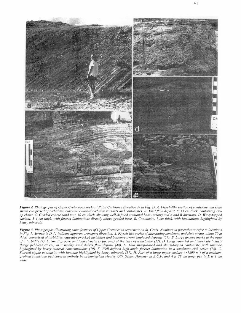
Figure 4. Photographs of Upper Cretaceous rocks at Point Cudejarre (location /8 in Fig. 1). A. Flysch-like section of sandstone and slate strata comprised of turbidites, current-reworked turbidite variants and contourites. B. Mast flow deposit, to 15 cm thick, containing rip-up clasts. C. Graded coarse sand unit, 10 cm thick, showing well-defined erosional base (arrow) and A and B divisions. D. Wavy-topped variant, 3-4 cm thick, with foreset laminations directly above graded base. E. Contourite, 7 cm thick, with laminations highlighted by heavy minerals.
Figure 3. Photographs illustrating some features of Upper Cretaceous sequences on St. Croix. Numbers in parentheses refer to locations in Fig. 1. Arrows in D-11 indicate apparent transport direction. A. Flysch-like series of alternating sandstone and slate strata, about 70 m thick, comprised of turbidites, current-reworked turbidites and bottom-current emplaced deposits (57). B. Large groove marks at the base of a turbidite (7). C. Small groove and load structures (arrows) at the base of a turbidite (12). D. Large rounded and imbricated clasts (large pebbles>20 cm) in a muddy sand debris flow deposit (48). E. Thin sharp-based and sharp-topped contourite, with laminae highlighted by heavy-mineral concentrations (19). F. Well-defined high-angle foreset lamination in a sandstone-rich series (18). C. Starved-ripple contourite with laminae highlighted by heavy minerals (57). H. Part of a large upper surface (>1800 m2) of a medium-grained sandstone bed covered entirely by asymmetrical ripples (57). Scale: Hammer in B,C,F, and /l is 28 cm long; pen in E is 1 cm wide.
42
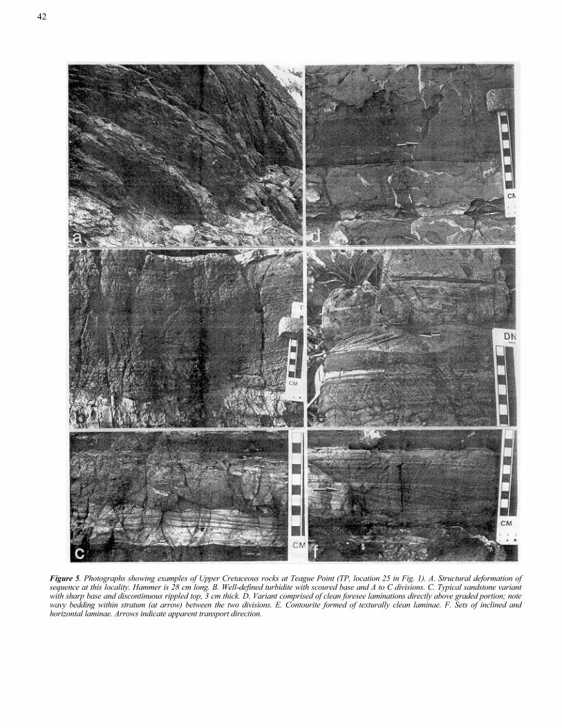
Figure 5. Photographs showing examples of Upper Cretaceous rocks at Teague Point (TP, location 25 in Fig. 1). A. Structural deformation of sequence at this locality. Hammer is 28 cm long. B. Well-defined turbidite with scoured base and A to C divisions. C. Typical sandstone variant with sharp base and discontinuous rippled top, 3 cm thick. D. Variant comprised of clean foresee laminations directly above graded portion; note wavy bedding within stratum (at arrow) between the two divisions. E. Contourite formed of texturally clean laminae. F. Sets of inclined and horizontal laminae. Arrows indicate apparent transport direction.

43
Figure 6. Scheme showing continuum of sediment types which may result from the reworking of a sandy layer originally emplaced as a complete A-E turbidite (1, at left). Reworking would result in partially eroded (2) and partially remolded turbidite (variant) series (3-7), to completely remolded and entirely foreset-laminated (8,9) and to discontinuous starved-ripple (10) layers. Stratal types 7 to 10 are the reworked "end-products" in this series. Progressive downward erosion and lateral disruption of the original turbidite layer are depicted. Examples of all types in this series are illustrated in Stanley (1987, 1988b).
(Whetten, 1966) or from low-concentration flows (Stanley, 1981, 1988b).
Downslope dispersal away from northern volcanic and clastic sources was suggested earlier by Whetten (1966). Additional directional measurements of groove casts, imbricated pebbles and other sedimentary features (Fig. 3b-d) show that gravity transport was primarily toward the south, south-southeast and south-southwest quadrants (Stanley, 1988a; see Fig. 7). Biodetrital material of shallow-marine origin mixed with terrigenous and volcanigenic components in the coarser beds suggests transport from a largely carbonate bank onto fairly steep slopes in a volcanically active region. These downslope-directed flows apparently entrained sediment basinward for considerable distances, depositing sediment as laterally continuous and well-stratified strata. Bottom-Current Deposits
Most Caledonia and Judith Fancy exposures include only a low proportion (usually <20%) of continuous, evenly bedded sandstone strata that, with certainty, would be identified as turbidites. More abundant in almost all sections are laminated sandstone layers that are distinct from turbidites but, although interspersed with them, appear to be deposited primarily by some form of tractive
fluid-driven mechanism (Figs. 3f-h, 4e, 5e,f). These comprise at least 25% of the sandy beds in some sections. Attributes of similar contourite layers deposited by deep-marine bottom currents in modern oceans have been described by Heezen and Hollister (1971), Hollister and Heezen (1972), Bouma and Hollister (1973), and Stow and Lovell (1979). Comparable sediments preserved in the rock record are illustrated by, among others, Hsu (1964), Bouma (1973), Anketell and Lovell (1976), Unrug (1977, 1980), Stow and Shanmugan (1980), and Lovell and Stow (1981).
Most sandy layers in Cretaceous units of St. Croix believed to be emplaced primarily by bottom currents are thin, ranging from 0.5 to 10 cm, but usually less than 3 cm thick. Their geometry is diverse: moderately even-bedded and fairly continuous (Fig. 5f), wedge-shaped, wavy bedded (Fig. 4e), or discontinuous (lenticular starved ripples, Fig. 3g). Instead of fining upward as in turbidites the bottom current-emplaced stratum is typically sharp-topped as well as sharp-based, and usually foreset- or cross-laminated throughout most, if not all of the bed (Fig. 5e). Laminae inclinations range from about 10° to 30°. The sharply defined upper stratal surface may be flat or wavy/undulating (Fig. 4e). Some thicker (to 30 cm) sandstones are entirely formed by large-scale megaripple
44
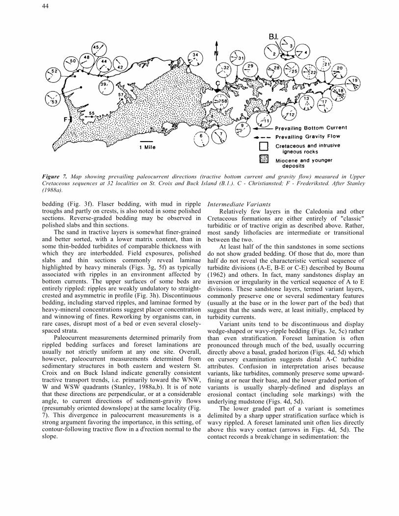
Figure 7. Map showing prevailing paleocurrent directions (tractive bottom current and gravity flow) measured in Upper Cretaceous sequences at 32 localities on St. Croix and Buck Island (B.1.). C - Christiansted; F - Frederiksted. After Stanley (1988a).
bedding (Fig. 3f). Flaser bedding, with mud in ripple troughs and partly on crests, is also noted in some polished sections. Reverse-graded bedding may be observed in polished slabs and thin sections.
The sand in tractive layers is somewhat finer-grained and better sorted, with a lower matrix content, than in some thin-bedded turbidites of comparable thickness with which they are interbedded. Field exposures, polished slabs and thin sections commonly reveal laminae highlighted by heavy minerals (Figs. 3g, 5f) as typically associated with ripples in an environment affected by bottom currents. The upper surfaces of some beds are entirely rippled: ripples are weakly undulatory to straight-crested and asymmetric in profile (Fig. 3h). Discontinuous bedding, including starved ripples, and laminae formed by heavy-mineral concentrations suggest placer concentration and winnowing of fines. Reworking by organisms can, in rare cases, disrupt most of a bed or even several closely-spaced strata.
Paleocurrent measurements determined primarily from rippled bedding surfaces and foreset laminations are usually not strictly uniform at any one site. Overall, however, paleocurrent measurements determined from sedimentary structures in both eastern and western St. Croix and on Buck Island indicate generally consistent tractive transport trends, i.e. primarily toward the WNW, W and WSW quadrants (Stanley, 1988a,b). It is of note that these directions are perpendicular, or at a considerable angle, to current directions of sediment-gravity flows (presumably oriented downslope) at the same locality (Fig. 7). This divergence in paleocurrent measurements is a strong argument favoring the importance, in this setting, of contour-following tractive flow in a direction normal to the slope.
Intermediate Variants Relatively few layers in the Caledonia and other
Cretaceous formations are either entirely of "classic" turbiditic or of tractive origin as described above. Rather, most sandy lithofacies are intermediate or transitional between the two.
At least half of the thin sandstones in some sections do not show graded bedding. Of those that do, more than half do not reveal the characteristic vertical sequence of turbidite divisions (A-E, B-E or C-E) described by Bouma (1962) and others. In fact, many sandstones display an inversion or irregularity in the vertical sequence of A to E divisions. These sandstone layers, termed variant layers, commonly preserve one or several sedimentary features (usually at the base or in the lower part of the bed) that suggest that the sands were, at least initially, emplaced by turbidity currents.
Variant units tend to be discontinuous and display wedge-shaped or wavy-ripple bedding (Figs. 3e, 5c) rather than even stratification. Foreset lamination is often pronounced through much of the bed, usually occurring directly above a basal, graded horizon (Figs. 4d, 5d) which on cursory examination suggests distal A-C turbidite attributes. Confusion in interpretation arises because variants, like turbidites, commonly preserve some upward-fining at or near their base, and the lower graded portion of variants is usually sharply-defined and displays an erosional contact (including sole markings) with the underlying mudstone (Figs. 4d, 5d).
The lower graded part of a variant is sometimes delimited by a sharp upper stratification surface which is wavy rippled. A foreset laminated unit often lies directly above this wavy contact (arrows in Figs. 4d, 5d). The contact records a break/change in sedimentation: the

45
current depositing the upper layers appears to have eroded and/or reworked the remnant turbidite divisions in the lower bed. The planar, horizontal-laminated B division, found above the graded A term of turbidites (Figs. 4c, 5b), is usually absent in sandy variants (Fig. 3e). Moreover, the lower graded (matrix-rich) portion of many sandy layers is topped by texturally cleaner foreset- and cross-laminated sections. These laminae, sometimes high-lighted by heavy minerals (as in contourites), record emplacement by tractive processes.
Thus, thin sandy strata, which on cursory observation in the field appear to be distal turbidites, are more reasonably interpreted as partially to thoroughly current-reworked turbidites. As in the case of contourites, some variants are bioturbated (Stanley, 1988b). The activity of benthic organisms may disrupt some or all original stratification, and thoroughly rework surficial layers between periodic incursions of sand. The generally good preservation of strata is probably a function of continuous sedimentation and relatively high rates of accumulation rather than a low benthic population. It appears that gravity-driven pulses of sediment supplied to the lower slope in this region were important and frequent, and that bottom current energy was sufficiently strong to redistribute the original turbidite sands laterally, often with only modest or no bioturbation.
THE PROPOSED MODEL
A sedimentation model is proposed on the basis of all the above petrologic observations. It involves tractive processes which, over time, can progressively erode a graded sand turbidite layer (Fig. 6). This downward reworking of the sand would best explain the disrupted (sometimes reversed) normal base-to-top sequence of turbidite bedform divisions. In cases where tractive processes continue, all of the sand grains forming a turbidite, including the basal graded portion, would be displaced and the original layer completely reworked. The expected "end-product" lithofacies would evolve to a diverse suite of bottom-current deposits. During this process, the original vertical sequence of turbidite bedform divisions are progressively disrupted as wavy and ripple bedding develops and a stratum becomes discontinuous laterally. This process may explain stratal pinch-out and development of clean sand lenses (such as starved ripples) observed between turbidites at outcrop localities (Figs. 3g, 4e). The truncation of laminae in the middle and upper parts of sand above the graded layer, such as in Fig. 5d, records rippling and erosion related to bottom-current processes. Tractive processes, rather than effects of turbidity-current flow, are also indicated by concentrations of heavy minerals along, and within, lamination surfaces.
Thus, the inventory of observed attributes indicates a continuum of sand deposits that progresses from complete A-E, B-E and incomplete turbidites through a series of partially to thoroughly current-reworked turbidites, and finally to deposits whose petrology records primarily a
tractive origin (Fig. 6). The final product is one where all original structures, bedforms, and fabric produced by sediment-gravity flows have been eradicated and replaced by new ones that record only the effects of erosion and bottom-current transport.
CONCLUSIONS
Structures, bedforms and textures in Caledonia Formation and Judith Fancy sections on St. Croix indicate that a natural series of sandy lithofacies exists between deposits emplaced by downslope-directed, gravity-driven flows and tractive bottom-current processes. The lower portion of variant sand layers may preserve the original basal graded (A) turbidite division while the middle and upper parts of such layers display structures more typically associated with tractive transport. The continuum of bedding sequences presented in Figure 6 is interpreted as a logical progression of sand types: sands initially emplaced by downslope gravity transport are subsequently reworked/remolded to a varying extent by bottom currents.
Volcaniclastic sand deposits were emplaced in a deep proximal setting, probably on lower slope aprons. This proximal base-of-slope interpretation is based primarily on the assemblages of selected facies including slides, slumps, coarse debris-flow deposits, sand-flow layers and coarse and complete (A-E) turbidites. Prevailing southward-directed transport directions are measured from structures in sediment-gravity flow deposits. At the same localities, paleocurrent measurements of features formed by bottom currents record predominantly westward transport trends. This near-perpendicular divergence of paleocurrent directions (Fig. 7) is a strong argument indicating that, after downslope transport, turbidites and associated layers were reworked, probably along bathymetric contours, by tractive processes. The flow of water above the sea floor, likely driven by thermohaline processes, was sufficiently strong to displace the coarse sand and granules forming volcaniclastic layers. The model of a turbidite to reworked sand continuum may help explain the origin of some sequences in modem oceans and elsewhere in the rock record where sandy turbidites appear petrologically anomalous or where a purely gravity-emplaced or tractive transport interpretation seems forced or remains questionable.
The predominant westerly paleocurrent measurements also are of note since they help to confirm the presence of deep-water circulation in this part of the paleo-Caribbean during the Late Cretaceous. This bottom-water flow pattern is roughly parallel to the westerly surface circulation postulated for this region between 100 and 65 m.y. ago by Bergren and Hollister (1974). The extensive bioturbation recorded in current-reworked sandy layers and interbedded mudstones (Stanley, 1988b) is an additional indication that circulation above the sea floor was not restricted and that bottom layers were not anoxic (cf. Simoneit, 1986). Moreover, the hypothesis that

46
sequences rich in turbidites and winnowed-reworked turbidites closely correspond to global lowstands of paleo-sealevel (Shanmugan and Moiola, 1982) clearly does not apply in this instance. On the contrary it would seem that bottom-water circulation prevailed during the Late Cretaceous, a period of high sea level.
ACKNOWLEDGEMENTS
Staff at the West Indies Laboratory in St. Croix, U.S. Virgin Islands, hosted us very pleasantly during eight field surveys from 1981 to 1989. Various manuscript drafts used for this paper were reviewed by Drs. L.J. Doyle, C.D. Hollister, D.K. Hubbard, I.G. Macintyre, H. Mullins, T. Nilsen, B.F. Thomas and J.T. Whetten, and I thank each of them for constructive suggestions which helped improve the text. Appreciation is expressed to Elsevier Scientific Publishers for authorization to reproduce text and figures from two of my papers (1987, 1988a) published in Marine Geology. Funding for the study was provided by several Smithsonian Scholarly Studies Program grants from the Assistant Secretary for Research, Smithsonian Institution.
REFERENCES CITED Anketell, J.M., and Lovell, J.P.B., 1976, Upper
Llandoverian Grogal sandstones and Aberystwyth Grits in the New Quay area, Central Wales: A possible upwards transition from contourites to turbidites, Geol. J. 11:101-108.
Bergren, W.A., and Hollister, C.D., 1974, Paleogeography,
paleobiostratigraphy and history of circulation in the Atlantic Ocean, in Hay, W.W., ed., Studies in Paleo-Oceanography, SEPM Spec. Publ. 20:126-186.
Bouma, A.H., 1962, Sedimentology of Some Flysch
Deposits, Elsevier, Amsterdam, 168 pp. Bouma, A.H., 1973, Fossil contourites in Lower
Niesenflysch, Switzerland, J. Sedim. Petrology 42:917-921.
Bouma, A.H., and Hollister, C.D., 1973, Deep ocean basin
sedimentation, in Middleton, G.V., and Bouma, A.H., eds., Turbidites and Deep-Water Sedimentation, Pacific Sec. SEPM, Los Angeles, Calif., pp. 79-118.
Burke, K., Cooper, C., Dewey, J.F., Mann, P., and Pindell,
J.L., 1984, Caribbean tectonics and relative plate motions, in Bonini, W.E., Hargraves, R.B., and Shagam, R., eds., The Caribbean-South American Plate Boundary and Regional Tectonics, GSA Memoir 162:31-63.
Case, J.E., Holcombe, T.L., and Martin, R.G., 1984, Map of geologic provinces in the Caribbean region, in Bonini, W.E., Hargraves, R.B., and Shagam, R., eds., The Caribbean-South American Plate Boundary and Regional Tectonics, GSA Memoir 162:1-30.
Ghosh, N., Hall, S.A., and Casey, J.F., 1984, Seafloor
spreading magnetic anomalies in the Venezuelan Basin, Bonini, W.E., Hargraves, R.B., and Shagam, R.,
eds., The Caribbean-South American Plate Boundary and Regional Tectonics, GSA Memoir 162:65-80.
Heezen, B.C., and Hollister, C.D., 1964, Deep-sea current
evidence from abyssal sediments, Mar. Geol. 1:141-174.
Heezen, B.C., and Hollister, C.D., 1971, The Face of the
Deep, Oxford Univ. Press, New York, N.Y., 659 pp. Hollister, C.D., and Heezen, B.C., 1972, Geologic effects
of ocean bottom currents: Western North Atlantic, in Gordon, A.L., ed., Studies in Physical Oceanography, Gordon and Breach, New York, N.Y., pp. 37-66.
Hsu, K.J., 1964, Cross-lamination in graded bed
sequences, J. Sedim. Petrology 34:379-388. Hubert, J.F., 1964, Textural evidence for deposition of
many Western North Atlantic deep-sea sands by ocean-bottom currents rather than turbidity currents, J. Geol. 72:757-785.
Kauffman, E.G., and Sohl, N.F., 1974, Structure and
evolution of Antillean Cretaceous rudist frameworks, Verh. Naturforsch. Ges. Basel 84:399-467.
Kuenen, Ph.H. and Humbert, F.L., 1969, Grain size of
turbidite ripples, Sedimentology 13:253-261. Lovell, J.P.B., and Stow, D.A.V., 1981, Identification of
ancient sandy contourites, Geology 9:347-349. Mattson, P.H., 1984, Caribbean structural breaks and plate
movements, in Bonini, W.E., Hargraves, R.B., and Shagam, R., eds., The Caribbean-South American Plate Boundary and Regional Tectonics, GSA Memoir 162:131-152.
Middleton, G.V., and Hampton, M.A., 1973, Sediment
gravity flows: mechanics of flow and deposition, in Middleton, G.V., and Bouma, A.H., eds., Turbidites and Deep-Water Sedimentation (Short Course). Pacific Sec. SEPM, Los Angeles, Calif., pp. 1-38.
Pindell, J., and Dewey, J.F., 1982, Permo-Triassic
reconstruction of western Pangea and the evolution of the Gulf of Mexico/Caribbean region, Tectonics 1:179-211.

47
Piper, D.J.W., 1978, Turbidite muds and silts on deep-sea fans and abyssal plains, in Stanley, D.J., and Kelling, G., eds., Sedimentation in Submarine Canyons, Fans, and Trenches, Dowden, Huchinson and Ross, Stroudsburg, PA, pp. 163-176.
Sclater, J.G., Hellinger, S., and Tapscott, C., 1977, The
paleobathymetry of the Atlantic Ocean from Jurassic to the present, J. Geol. 85:442-509.
Shanmugan, G., and Moiola, R.J., 1982, Eustatic control
of turbidites and winnowed turbidites, Geology 10:231-235.
Shanmugan, G., and Walker, K.R., 1978, Tectonic
significance of distal turbidites in the middle Ordovician Blockhouse and Lower Sevier formations in east Tennessee, Am. J. Sci. 278:551-578.
Simoneit, B.R.T., 1986, Biomarker geochemistry of black
shales from Cretaceous oceans, Mar. Geol. 70:9-41. Speed, R.C., 1974, Depositional realm and deformation of
Cretaceous rocks, East End, St. Croix, in Multer, H.G., and Gerhard, L.C., eds., Guidebook to the Geology and Ecology of Some Marine and Terrestrial Environments, St. Croix, U.S. Virgin Islands, West Indies Lab. Spec. Publ. No. 5, Christiansted, St. Croix, pp. 189-200.
Speed, R.C., Gerhard, L.C., and McKee, E.H., 1979,
Ages of deposition, deformation and intrusion of Cretaceous rocks, eastern St. Croix, Virgin Islands, GSA Bull. 90:629-632.
Stanley, D.J., 1981, Unifites: structureless muds of
gravity flow origin in Mediterranean basins, Geo-Mar. Lett. 1:77-83.
Stanley, D.J., 1987, Turbidite to current-reworked sand
continuum in Upper Cretaceous rocks, U.S. Virgin Islands, Mar. Geol. 78:143-151.
Stanley, D.J., 1988a, Deep-sea current flow in the Late
Cretaceous Caribbean: Measurements in St. Croix, U.S. Virgin Islands, Mar. Geol. 79:127-133.
Stanley, D.J., 1988b, Turbidites reworked by bottom currents: Upper Cretaceous examples from St. Croix, U.S. Virgin Islands, Smithsonian Contrib. Mar. Sci. 33:79 pp.
Stanley, D.J., Palmer, H.D., and Dill, R.F., 1978, Coarse
sediment transport by mass flow and turbidity current processes and downslope transformations in Annot Sandstone canyon-fan valley systems, in Stanley, D.J., and Kelling, G., eds., Sedimentation in Submarine Canyons, Fans and Trenches, Dowden, Huchinson, and Ross, Stroudsburg, PA, pp. 85-115.
Stanley, D.J., and Taylor, P.T., 1977, Sediment transport
down a seamount flank by a confined current and gravity process, Mar. Geol. 23:77-88.
Stow, D.A.V., and Lovell, J.P.B., 1979, Contourites: their
recognition in modem and ancient sediments, Earth-Sci. Rev. 14:251-291.
Stow, D.A.V., and Shanmugan, G., 1980, Sequence of
structures in fine-grained turbidites: comparison of recent deep-sea and ancient flysch sediments, Sediment. Geol. 25:23-42.
Unrug, R., 1977, Ancient deep-sea traction current
deposits in the Lgota beds (Albian) of the Carpathian flysch, Ann. Soc. Geol. Pol. 47:355-370.
Unrug, R., 1980, Ancient contourites in the Menilite beds
(Oligocene) of the Carpathian flysch, Poland, Ann. Soc. Geol. Pol. 50:175-182.
Vila, J.M., Andreieff, P., Belon, H., and Mascle, A.,
1986, Tectonique de collage le long d'un accident decrochant, ante-oligocene, est-ouest, dans les lies Vierges septentrionales (Antilles), C.R. Acad. Sci. Paris 302:141-144.
Walker, R.G., 1965, The origin and significance of the
internal sedimentary structures of turbidites, Proc. Yorks. Geol. Soc. 35:1-32.
Whetten, J.T., 1966, Geology of St. Croix, U.S. Virgin
Islands, in Hess, H.H., ed., Caribbean Geological Investigations, GSA. Memoir 98:177-239.