sedimentation and soil formation phases in the ghardimaou ... · previous stratigraphical and...
TRANSCRIPT

Quaternary International 93–94 (2002) 109–125
Sedimentation and soil formation phases in the Ghardimaou Basin(northern Tunisia) during the Holocene
Christoph Zielhofera,*, Dominik Fausta, Fernando Diaz del Olmob,Rafael Baena Escuderob
aTU Dresden, D-01062 Dresden, GermanybUniversidad de Sevilla, E-41004 Sevilla, Spain
Abstract
Chronological and stratigraphical interpretations as well as 14C-dates and geoarchaeological investigations of detailed profiles
from the mid-Medjerda valley (northern Tunisia) allow us to reconstruct one late Pleistocene and four Holocene sedimentation
cycles within the floodplain area. Initial results from pedological examinations, including thin sections, indicate a latest Pleistocene
and three Holocene soil formation periods. Our observations from the Medjerda valley are discussed in relation to current research
in the southwestern Mediterranean region. The Crise Romaine—shown in the headwaters of the Medjerda river system by thick
cobble accumulations—is exhibited in the basin region by a clear accentuation of the water level amplitude. Catastrophic flooding
can be observed for the first time in the late Roman period. After soil formation during Middle Ages, ending at about 450 BP,
flooding again increased. r 2002 Elsevier Science Ltd and INQUA. All rights reserved.
1. Introduction
During the DFG-Project, ‘‘Reconstruction of Holo-cene environmental conditions in North-Tunisia basedon sedimentological analysis and pedogenetic findingsfrom the mid-Medjerda valley’’, detailed profiles ofouter bank positions of the Oued Medjerda were carriedout. From chronological and stratigraphical interpreta-tions we are able to reconstruct the water levelamplitude of the river during the Holocene. Miner-alogical, palaeomagnetic, pedological and geoarchaeo-logical examinations, as well as 14C-dates, allowderivation of soil formation and sedimentation cycles.The initial results of the ongoing project broadenknowledge of morphodynamics during the Holocene innorthern Tunisia and allow us, to some extent, to drawparallels to comparable work in the West-Mediterra-nean region.
2. Area of investigation
The Oued Medjerda is the main water course inNorth-Tunisia. The northern catchment area includesthe subhumid to Mediterranean-humid south facing
slope of the Tunisian Tell region, whose hills in theKroumir Mountains reach to over 1200m. A muchgreater catchment area lies in the south, drained by themain tributaries Oued Melleque, Oued Tessa and OuedSiliana (Fig. 1). They drain the north-facing slopes andpiedmonts of the semiarid Dorsal Mountains. The OuedMedjerda itself rises in the semiarid Atlas Mountains ofeastern Algeria. In the area of the upper middle course,before the river is joined by the main southerntributaries, it passes through the Ghardimaou Basin(Fig. 2), a tectonic depression with 8–10m thickHolocene floodplain sediments. The Ghardimaou Basinhas been settled since at least the latest Palaeolithics, asshown by many artifacts found within the sedimentlayers.
3. Methods
The profiles we have introduced are limited to theGhardimaou Basin (Fig. 3) and are the result of a 6-week stay in the project area itself. Profiles taken fromthe eastern linked Jendouba Basin (Fig. 3) remain at thispoint unexamined, as the complex fluvial dynamics ofthe tributaries hinder the recognition of sedimentationseries during the Holocene.*Corresponding author.
1040-6182/02/$ - see front matter r 2002 Elsevier Science Ltd and INQUA. All rights reserved.
PII: S 1 0 4 0 - 6 1 8 2 ( 0 2 ) 0 0 0 1 0 - 1

Previous stratigraphical and chronological analysisof sedimentation in the Ghardimaou Basin is based onthe dating of many artifacts and pottery fragments, 14C-dating (AMS) of charcoal (calibrated after Stuiver et al.,1998), pedological and sedimentological field observa-tions (color, soil texture, soil structure, bioturbation,humic content, rubefaction, calcareous concretions,etc.), as well as comparison of individual profiles.Fortunately, the charcoal samples consisted almostentirely of in situ fire-sites, so that we can assume thatwe dated reliable material. Palaeomagnetic analysis ofthe samples is still ongoing.
4. Key profiles in the Ghardimaou Basin
The most important profiles for the Ghardimaou Basinare those of (OM) Chemtou (CH) and Sidi Abdallah(SA) (Fig. 3). After the initial observations of the outerbank positions within the basin, these profiles werechosen for detailed soil sampling and analysis. Thesethree exposures allowed observation of the sedimentationand soil formation spectrum during the Holocene in asomewhat representative and compressed form.
4.1. Oued Mliz Profile (OM)
This site lies approx. 500m northeast of the village ofOM. The village takes its name from the small, southerntributary, which enters the Ghardimaou Basin in thisarea. Thus the exposure lies in the interlocking area ofOued Medjerda as well as that of OM. The actuallocation is an outer bank position of the OM directlybefore it joins the Oued Medjerda (Fig. 3).
In the OM, 16 sediment layers were defined accordingto field observations and laboratory analysis (Fig. 4),grouped into five main sedimentation series (Fig. 7).With the exception of the first incomplete series (S1), thebasal sequences of series S2–S4 mainly show sandy tosilty soil texture, with the upper parts of the individualseries fining upwards to clayey sediments.
Series S1 (980–620 cm) consists of, from base to top:
* OM1: silty clay, very calcareous, hydromorphicfeatures (weak staining of slightly developed aggre-gate surfaces);
* In situ fire-site, 11,440750 BP (13,790–13,160 CalBP; Beta-135718);
* OM2: silty clay, very calcareous, slightly aggregated,hydromorphic features.
Series S2 begins with rhythmic lamination of silty–clayey to medium-sandy sediments (OM3). In someplaces gravel layers (OM4; loamy sand, very calcareous)are embedded. The overlying OM5 layer is clay loam,extreme calcareous, subangular blocky (7.5 to 10 YR 6/4,light brown to light yellowish-brown). This unit istransitional along a diffuse contact to clearly aggre-gated, subangular blocky, calcareous, humic, silty clay(OM6). S2 closes with sediment (OM5 to 6) indicatingsoil formation beyond the degree of simple humicenrichment. The light reddish-brown color and thesubangular blocky structure of the clay loam (OM5)show slight rubefaction. Bean-sized calcareous concre-tions in the lower part of S2 indicate calcareousprecipitation during soil formation.
Series S3 (440–250 cm) consists of (Fig. 4):
* OM7: silty clay, very calcareous, prismatic structure,hydromorphic features (2.5 Y 5/4, light olive-brown),30–160 cm thickness;
Catchment area of theOued Medjerda
Tunis
Tabarka
SousseKairouan
N
0 50 100 km
Kroumir Mountains
Dorsal M
ountains
Tunisia
Fig. 1. Catchment area of the Oued Medjerda.
Fig. 2. Ghardimaou Basin—view from the Northeast (photo).
C. Zielhofer et al. / Quaternary International 93–94 (2002) 109–125110

Fig.3.Areaofinvestigationandkey
profiles.
C. Zielhofer et al. / Quaternary International 93–94 (2002) 109–125 111
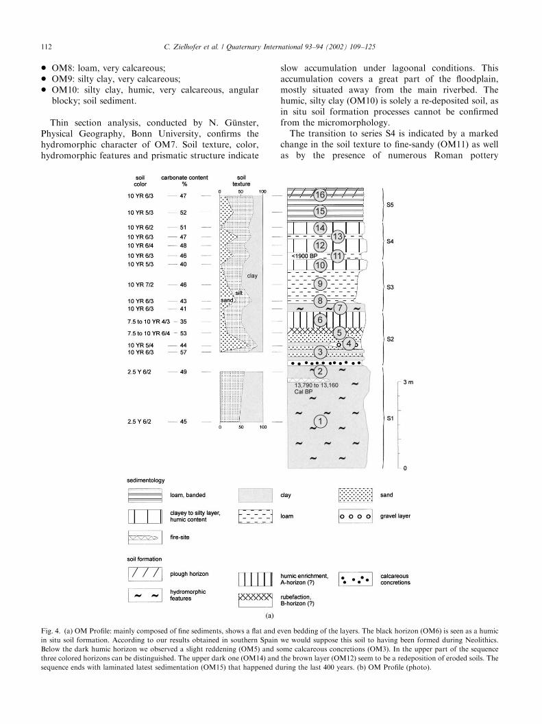
* OM8: loam, very calcareous;* OM9: silty clay, very calcareous;* OM10: silty clay, humic, very calcareous, angular
blocky; soil sediment.
Thin section analysis, conducted by N. G .unster,Physical Geography, Bonn University, confirms thehydromorphic character of OM7. Soil texture, color,hydromorphic features and prismatic structure indicate
slow accumulation under lagoonal conditions. Thisaccumulation covers a great part of the floodplain,mostly situated away from the main riverbed. Thehumic, silty clay (OM10) is solely a re-deposited soil, asin situ soil formation processes cannot be confirmedfrom the micromorphology.
The transition to series S4 is indicated by a markedchange in the soil texture to fine-sandy (OM11) as wellas by the presence of numerous Roman pottery
Fig. 4. (a) OM Profile: mainly composed of fine sediments, shows a flat and even bedding of the layers. The black horizon (OM6) is seen as a humic
in situ soil formation. According to our results obtained in southern Spain we would suppose this soil to having been formed during Neolithics.
Below the dark humic horizon we observed a slight reddening (OM5) and some calcareous concretions (OM3). In the upper part of the sequence
three colored horizons can be distinguished. The upper dark one (OM14) and the brown layer (OM12) seem to be a redeposition of eroded soils. The
sequence ends with laminated latest sedimentation (OM15) that happened during the last 400 years. (b) OM Profile (photo).
C. Zielhofer et al. / Quaternary International 93–94 (2002) 109–125112
fragments (o1900 BP). Series S4 (250–120 cm) consistsof
* OM11: fine sandy loam, very calcareous;* OM12: clay loam, very calcareous, reddish; Roman
ceramics;* OM13: sandy clay loam, very calcareous;* OM14: silty clay, humic, subangular blocky, extreme
calcareous; soil sediment, as indicated by thin sectionanalysis. The micromorphology shows clearly strati-fied accumulation.
The youngest floodplain sediment (S5; 120–0 cm)represents finely banded deposits of loam (OM15) tosilty loam (OM16). The inhomogeneous matrix dis-tinctly borders S5 from the underlying series. Soilformation characteristics are not present.
4.2. Chemtou Profile (CH)
The CH lies close to the ancient Roman city Chemtou(see Fig. 3). Due to the North-African Atlas orogenesis,an outcrop of Jurassic marble is located here. Theyellowish Chemtou-Marble has been quarried andexported since Antiquity. Similar to the OM Profile,
the CH does not lie directly in the meandering belt of theOued Medjerda, but on an outer bank position of thesmall northern tributary Oued Melah, shortly after itenters the northern edge of the Ghardimaou Basin. Theprofile represents the interlocking sedimentation area ofboth rivers.
Fig. 5 shows the CH containing exposures from innerbank to outer bank positions. Altogether 23 layers,including some which are only fluviatile facies, aredivided into—similar to the OM Profile—five mainsedimentation series (Fig. 7: S1–S5).
Series S1 (850–510 cm) consists of
* CH1: silty clay loam, calcareous, angular blocky;calcareous concretions;
* CH2: silty clay loam, noncalcareous aggregatesurfaces, angular blocky;
* CH3: clay, noncalcareous, angular blocky, clay films;B-horizon (5–7.5 YR 4/6, yellowish-red to strongbrown);
* CH4: silty clay, calcareous;* CH5: in situ cultural layer (Ib!eromaurusien);
11,160750 BP (13,360–12,990 Cal BP; Beta-135726).
In the lowermost part of series S1, a reddish soil hasdeveloped (CH1–CH3), whose humic horizon has beeneroded. The clay-rich B-horizon (CH3) is fully decalci-fied, has a markedly angular blocky structure anddisplays clay films on aggregate faces. The subsoil (CH1)exhibits bean-sized calcareous concretions in a calcic,grayish-brown soil matrix.
Series S1 concludes with an in situ cultural layer(CH5) with a thickness of between 50 and 70 cm. Thecultural layer, in Tunisian literature known as escargoti-"eres (Bourgou, 1993), shows numerous charcoal re-mains, snail shells, bones, and many angular, chipped-off gravels and cobbles. Despite an intense search,however, a datable industry could not be found. The14C dating of the in situ charcoal samples resultedin a calibrated 14C-age of 13,360–12,990 BP(Ib!eromaurusian culture). Therefore, the developmentof the underlying, red soil must have been completedsomewhere around 14,000 BP. The compaction of thehematitic (5–7.5 YR 4/6) B-horizon (CH3) has hinderedsecondary calcification.
Series S2 (810–600 cm) consists of, from base to top:
* CH–N0: gravel layer, calcareous;* CH–N1: clay loam, extreme calcareous, calcareous
concretions;* CH–N2: clay, subangular blocky, very calcareous;
B-horizon (10 YR 5/6, yellowish brown);* CH–N3: clay, subangular blocky, calcareous;
A-horizon.
In an outer bank position lying approx. 200m downriver (see Fig. 5a) the almost completely eroded,Pleistocene layer is covered by a thin gravel layer
Fig. 4 (continued).
C. Zielhofer et al. / Quaternary International 93–94 (2002) 109–125 113

Fig. 5. (a) CH: The CH profile is in our point of view the most complete in the whole Ghardimaou Basin. It shows nearly the complete Holocene sequence beginning after a soil formation phase of
the latest Pleistocene. Rubefacted features point to latest Pleistocene climatic conditions that enabled the reddening (sharp contrast of seasons). Above the red soil charcoal and lots of snail shells
witness in situ remnants of an ancient settlement. 14C-analysis of the charcoal indicate an age of 13,360–12,990 Cal BP. (b) Late Pleistocene soil in the CH (photo).
C.Zielh
ofer
etal./Quatern
ary
Intern
atio
nal93–94(2002)109–125
114
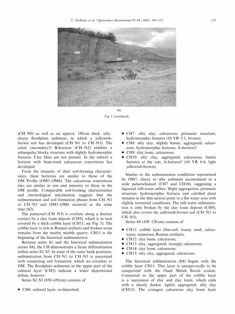
(CH–N0) as well as an approx. 180 cm thick, silty–clayey floodplain sediment, in which a yellowish-brown soil has developed (CH–N1 to CH–N3). Thecalcic (secondary?) B-horizon (CH–N2) exhibits asubangular blocky structure with slightly hydromorphicfeatures. Clay films are not present. In the subsoil ahorizon with bean-sized calcareous concretions hasdeveloped.
From the intensity of their soil-forming character-istics, these horizons are similar to those of theOM Profile (OM3–OM6). The calcareous concretionsalso are similar in size and intensity to those in theOM profile. Comparable soil-forming characteristicsand chronological information suggests that thesedimentation and soil formation phases from CH–N1to CH–N3 and OM3–OM6 occurred at the sametime (S2).
The palaeosol (CH–N3) is overlain along a distinctcontact by a clay loam deposit (CH9), which is in turncovered by a thick cobble layer (CH11; see Fig. 5). Thecobble layer is rich in Roman artifacts and broken stoneremains from the nearby marble quarry. CH11 is thebeginning of the historical sedimentation.
Between series S1 and the historical sedimentation(series S4), the CH demonstrates a facies differentiationwithin series S2–S3. In some of the outer bank positions,sedimentation from CH–N1 to CH–N3 is associatedwith connecting soil formation, which we correlate toOM. The floodplain sediments in the upper part of thecultural layer (CH5) indicate a wider depositionalmilieu, however.
Series S2–S3 (850–430 cm) consists of
* CH6: cultural layer, re-deposited;
* CH7: silty clay, calcareous, prismatic structure,hydromorphic features (10 YR 5/3, brown);
* CH8: silty clay, slightly humic, aggregated, calcar-eous, hydromorphic features; A-horizon?;
* CH9: clay loam, calcareous;* CH10: silty clay, aggregated, calcareous, humic
features at the top; A-horizon? (10 YR 6/4, lightyellowish-brown).
Similar to the sedimentation conditions representedby OM7, clayey to silty sediment accumulated in awide palaeochannel (CH7 and CH10), suggesting alagoonal still-water milieu. Slight aggregation, prismaticstructure, hydromorphic features and calcified plantremains in the thin section point to a flat water area withslightly terrestrial conditions. The still water sedimenta-tion is only broken by the clay loam deposit (CH9),which also covers the yellowish-brown soil (CH–N1 toCH–N3).
Series S4 (430–120 cm) consists of
* CH11: cobble layer (fine-soil: loamy sand, calcar-eous), numerous Roman artifacts;
* CH12: clay loam, calcareous;* CH13: clay, aggregated, strongly calcareous;* CH14: clay loam, calcareous;* CH15: silty clay, aggregated, calcareous.
The historical sedimentation (S4) begins with thecobble layer CH11. This layer is unequivocally to becategorized with the Oued Melah fluvial system.Connected to the upper part of the cobble layeris a succession of clay and clay loam, which endswith a clearly darker, lightly aggregated, silty clay(CH15). The youngest calcareous clay loam layer
Fig. 5 (continued).
C. Zielhofer et al. / Quaternary International 93–94 (2002) 109–125 115
(CH16; 120–0 cm) corresponds to the series S5 in theOM Profile.
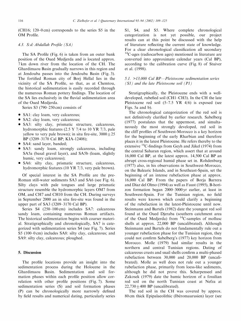
4.3. S:d: Abdallah Profile (SA)
The SA Profile (Fig. 6) is taken from an outer bankposition of the Oued Medjerda and is located approx.7 km down river from the location of the CH. TheGhardimaou Basin gradually narrows in this region andat Jendouba passes into the Jendouba Basin (Fig. 3).The fortified Roman city of Borj Hellal lies in thevicinity of the SA Profile, so that, as at Chemtou,the historical sedimentation is easily recorded throughthe numerous Roman pottery findings. The location ofthe SA lies exclusively in the fluvial sedimentation areaof the Oued Medjerda.
Series S3 (790–250 cm) consists of
* SA1: clay loam, very calcareous;* SA2: clay loam, very calcareous;* SA3: silty clay, prismatic structure, calcareous,
hydromorphic features (2.5 Y 7/4 to 10 YR 7/3, paleyellow to very pale brown); in situ fire-site, 3000725BP (3209–3170 Cal BP; KIA-12408);
* SA4: sand layer, banded;* SA5: sandy loam, strongly calcareous, including
SA5a (basal gravel layer), and SA5b (loam, slightlyhumic, very calcareous);
* SA6: silty clay, prismatic structure, calcareous,hydromorphic features (10 YR 7/3, very pale brown).
Of special interest in the SA Profile are the pre-Roman still-water sediments SA3 and SA6 (see Fig. 6).Silty clays with pale tongues and large prismaticstructure resemble the hydromorphic layers OM7 fromOM, and CH7 and CH10 from the CH. During surveysin September 2000 an in situ fire-site was found in theupper part of SA3 (3209–3170 Cal BP).
Series S4 (250–100 cm) includes SA7: calcareoussandy loam, containing numerous Roman artifacts.The historical sedimentation begins with coarser materi-al. Stratigraphically and chronologically, SA7 is cate-gorized with sedimentation series S4 (see Fig. 7). SeriesS5 (100–0 cm) includes SA8: silty clay, calcareous; andSA9: silty clay, calcareous; ploughed.
5. Discussion
The profile locations provide an insight into thesedimentation process during the Holocene in theGhardimaou Basin. Sedimentation and soil for-mation phases within each profile position allow cor-relation with other profile positions (Fig. 7). Somesedimentation series (S) and soil formation phases(P) can be chronologically more narrowly definedby field results and numerical dating, particularly series
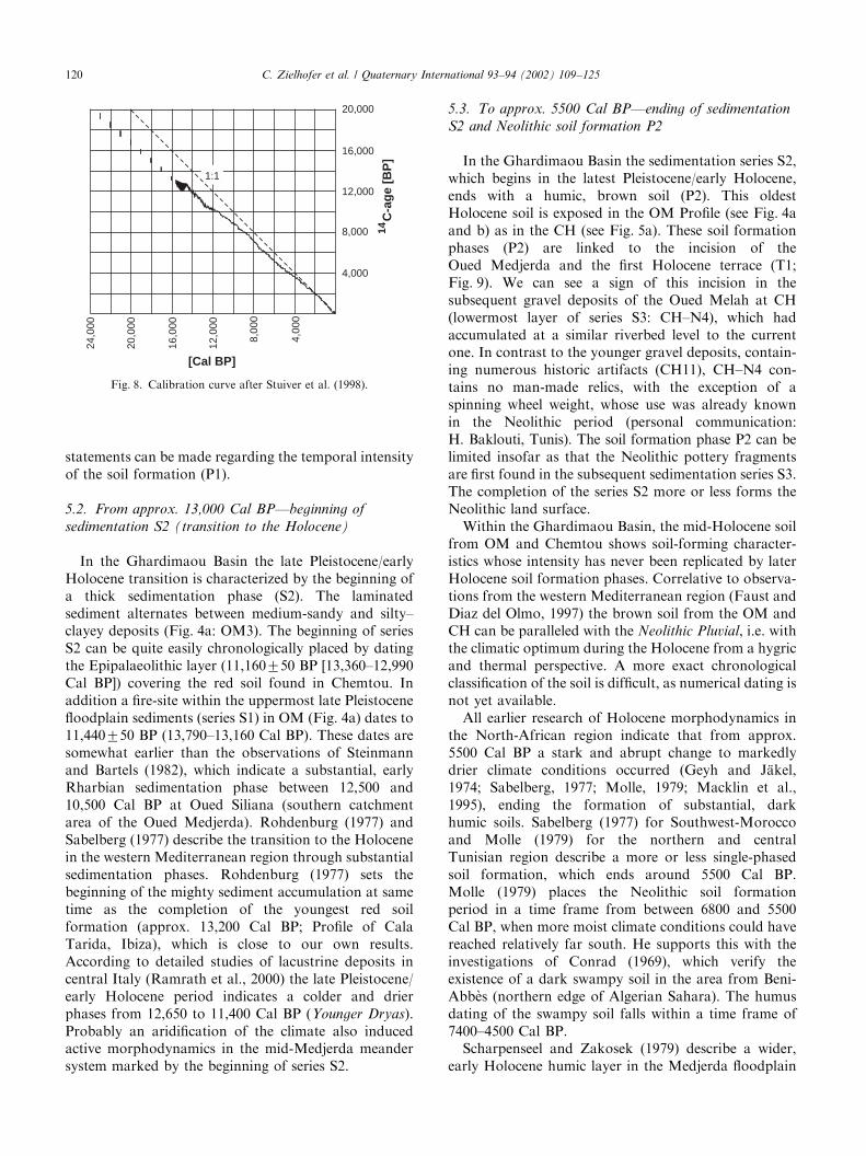
S1, S4, and S5. Where complete chronologicalcategorization is not yet possible, our projectresults can at this point be discussed with the helpof literature reflecting the current state of knowledge.For a clear chronological classification all secondary14C-ages (radiocarbon ages) mentioned in literature areconverted into approximate calendar years (Cal BP),according to the calibration curve (Fig. 8) of Stuiveret al. (1998).
5.1. >13,000 Cal BP—Pleistocene sedimentation series
(S1) and the late Pleistocene soil (P1)
Stratigraphically, the Pleistocene ends with a well-developed, rubefied soil (CH1–CH3). In the CH the latePleistocene red soil (5–7.5 YR 4/6) is exposed (seeFigs. 5a and b).
The chronological categorization of the red soil isnot definitively clarified by earlier research. Sabelberg(1977) postulates that the uppermost, and simulta-neously the most strongly developed, red soil inthe cliff profiles of Southwest-Morocco is a key horizonfor the beginning of the early Rharbian and thereforeplaces it in the latest Pleistocene. He refers thereby to theextensive 14C-findings from Geyh and J.akel (1974) fromthe central Saharan region, which assert that at around16,000 Cal BP, at the latest approx. 14,500 Cal BP anabrupt cross-regional humid phase set in. Rohdenburg(1977) also, in his observations in Southwest-Morocco,on the Balearic Islands, and in Southeast-Spain, set thebeginning of an intense rubefaction phase at approx.16,000 Cal BP. From the papers of Borja Barreraand Diaz del Olmo (1994) as well as Faust (1995), B-hori-zon formation began 2000–3000 yr earlier, at least inSouthwest-Spain. For the Tunisian region, no fieldresults were known which could clarify a beginningof the rubefaction in the latest-Pleistocene until now.Steinmann and Bartels (1982) date the youngest red soilfound at the Oued Djeraba (southern catchment areaof the Oued Medjerda) from 14C-samples of molluscshells at approx. 22,000 BP (uncalibrated). AlthoughSteinmann and Bartels do not fundamentally rule out ayounger rubefaction phase for the Tunisian region, theycould not confirm Sabelberg’s (1977) key horizon fromMorocco. Molle (1979) had similar results in thenorthern and central Tunisian regions. Dating ofcalcareous crusts and snail shells confirm a multi-phasedrubefaction between 30,000 and 20,000 BP (uncali-brated). Molle as well does not rule out a youngerrubefaction phase, primarily from loess-like sediments,although he did not prove this. Scharpenseel andZakosek (1979) date the humic horizon of a fossilianred soil on the north Tunisian coast at Nefza at22,7307400 BP (uncalibrated).
The red soil in the CH was covered by approx.80 cm thick Epipalaeolithic (Ib!eromaurusien) layer (see
C. Zielhofer et al. / Quaternary International 93–94 (2002) 109–125116

Figs. 5a and b). The dating of in situ charcoal provideda 14C age of 11,160750 BP (13,360–12,990 Cal BP).Although the A-horizon of the soil is eroded, thefindings are at least evidence of the end of a strong soil
formation phase (P1) in the earliest Rharbian andthereby, possibly provide proof for Sabelberg’s (1977)key horizon for the Tunisian region. If future OSL-dating of the sediment series (S1) is successful,
Fig. 6. (a) SA Profile: Of special interest is the pre-Roman sedimentation of the layers 3 and 6. We assume slow accumulation conditions proved by
fine silty and clayey deposits. They are characterized by grayish to light greenish coloring, by slight humic contents and by clear prismatic structure.
Layers 3 and 6 can be recognized also in CH Profile (7 and 10) as pre-Roman sedimentation. (b) SA Profile—noticeable are two thick still-water
deposits with distinct prismatic structures (photo).
C. Zielhofer et al. / Quaternary International 93–94 (2002) 109–125 117
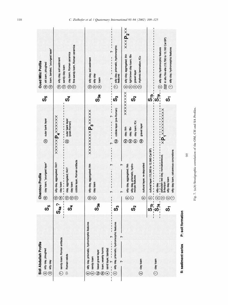
Fig.7.(a,b)Stratigraphic
correlationoftheOM,CH
andSA
Profiles.
C. Zielhofer et al. / Quaternary International 93–94 (2002) 109–125118
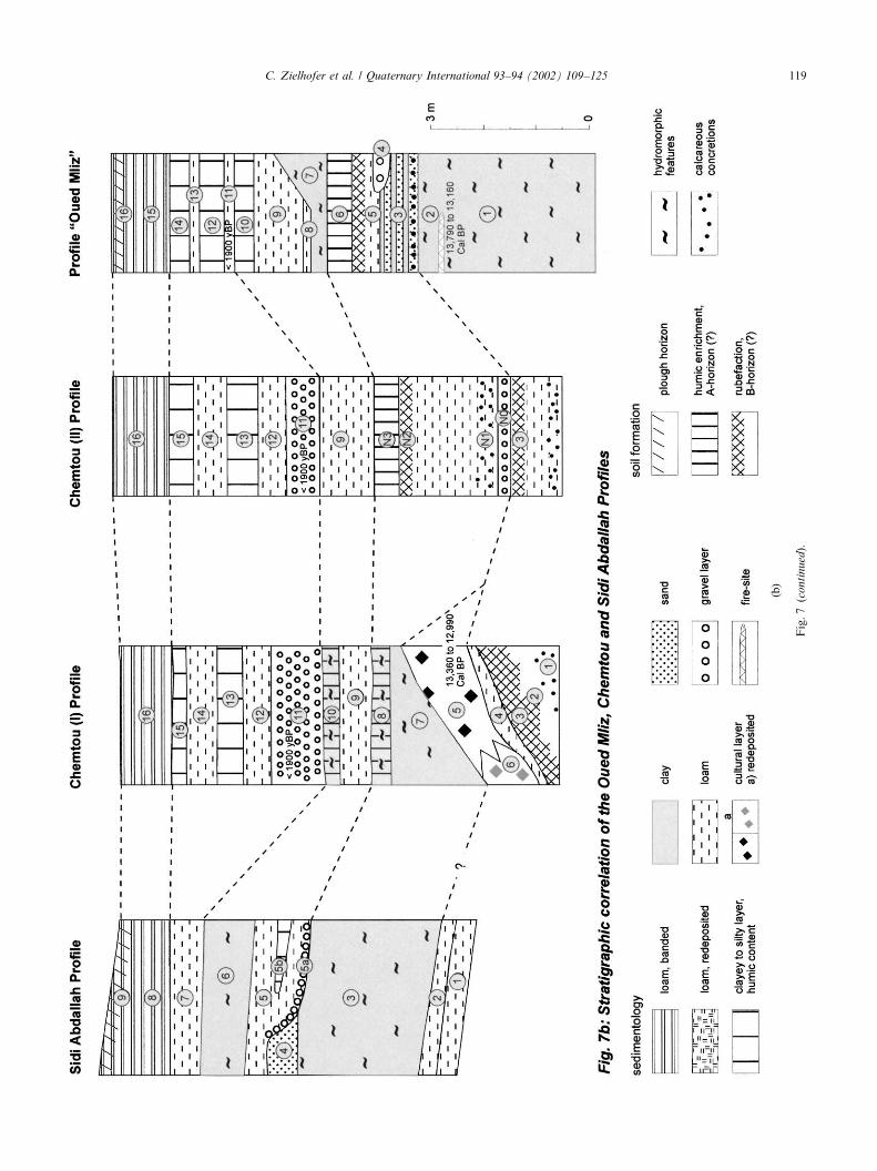
Fig.7(continued).
C. Zielhofer et al. / Quaternary International 93–94 (2002) 109–125 119
statements can be made regarding the temporal intensityof the soil formation (P1).
5.2. From approx. 13,000 Cal BP—beginning of
sedimentation S2 (transition to the Holocene)
In the Ghardimaou Basin the late Pleistocene/earlyHolocene transition is characterized by the beginning ofa thick sedimentation phase (S2). The laminatedsediment alternates between medium-sandy and silty–clayey deposits (Fig. 4a: OM3). The beginning of seriesS2 can be quite easily chronologically placed by datingthe Epipalaeolithic layer (11,160750 BP [13,360–12,990Cal BP]) covering the red soil found in Chemtou. Inaddition a fire-site within the uppermost late Pleistocenefloodplain sediments (series S1) in OM (Fig. 4a) dates to11,440750 BP (13,790–13,160 Cal BP). These dates aresomewhat earlier than the observations of Steinmannand Bartels (1982), which indicate a substantial, earlyRharbian sedimentation phase between 12,500 and10,500 Cal BP at Oued Siliana (southern catchmentarea of the Oued Medjerda). Rohdenburg (1977) andSabelberg (1977) describe the transition to the Holocenein the western Mediterranean region through substantialsedimentation phases. Rohdenburg (1977) sets thebeginning of the mighty sediment accumulation at sametime as the completion of the youngest red soilformation (approx. 13,200 Cal BP; Profile of CalaTarida, Ibiza), which is close to our own results.According to detailed studies of lacustrine deposits incentral Italy (Ramrath et al., 2000) the late Pleistocene/early Holocene period indicates a colder and drierphases from 12,650 to 11,400 Cal BP (Younger Dryas).Probably an aridification of the climate also inducedactive morphodynamics in the mid-Medjerda meandersystem marked by the beginning of series S2.
5.3. To approx. 5500 Cal BP—ending of sedimentation
S2 and Neolithic soil formation P2
In the Ghardimaou Basin the sedimentation series S2,which begins in the latest Pleistocene/early Holocene,ends with a humic, brown soil (P2). This oldestHolocene soil is exposed in the OM Profile (see Fig. 4aand b) as in the CH (see Fig. 5a). These soil formationphases (P2) are linked to the incision of theOued Medjerda and the first Holocene terrace (T1;Fig. 9). We can see a sign of this incision in thesubsequent gravel deposits of the Oued Melah at CH(lowermost layer of series S3: CH–N4), which hadaccumulated at a similar riverbed level to the currentone. In contrast to the younger gravel deposits, contain-ing numerous historic artifacts (CH11), CH–N4 con-tains no man-made relics, with the exception of aspinning wheel weight, whose use was already knownin the Neolithic period (personal communication:H. Baklouti, Tunis). The soil formation phase P2 can belimited insofar as that the Neolithic pottery fragmentsare first found in the subsequent sedimentation series S3.The completion of the series S2 more or less forms theNeolithic land surface.
Within the Ghardimaou Basin, the mid-Holocene soilfrom OM and Chemtou shows soil-forming character-istics whose intensity has never been replicated by laterHolocene soil formation phases. Correlative to observa-tions from the western Mediterranean region (Faust andDiaz del Olmo, 1997) the brown soil from the OM andCH can be paralleled with the Neolithic Pluvial, i.e. withthe climatic optimum during the Holocene from a hygricand thermal perspective. A more exact chronologicalclassification of the soil is difficult, as numerical dating isnot yet available.
All earlier research of Holocene morphodynamics inthe North-African region indicate that from approx.5500 Cal BP a stark and abrupt change to markedlydrier climate conditions occurred (Geyh and J.akel,1974; Sabelberg, 1977; Molle, 1979; Macklin et al.,1995), ending the formation of substantial, darkhumic soils. Sabelberg (1977) for Southwest-Moroccoand Molle (1979) for the northern and centralTunisian region describe a more or less single-phasedsoil formation, which ends around 5500 Cal BP.Molle (1979) places the Neolithic soil formationperiod in a time frame from between 6800 and 5500Cal BP, when more moist climate conditions could havereached relatively far south. He supports this with theinvestigations of Conrad (1969), which verify theexistence of a dark swampy soil in the area from Beni-Abb"es (northern edge of Algerian Sahara). The humusdating of the swampy soil falls within a time frame of7400–4500 Cal BP.
Scharpenseel and Zakosek (1979) describe a wider,early Holocene humic layer in the Medjerda floodplain
[Cal BP]
4,000
4,00
0
8,00
0
12,0
00
16,0
00
20,0
00
24,0
00
8,000
12,000
16,000
20,000
C-a
ge
[BP
]14
1:1
Fig. 8. Calibration curve after Stuiver et al. (1998).
C. Zielhofer et al. / Quaternary International 93–94 (2002) 109–125120

at Bou Salem (Jendouba Basin; Fig. 3), the humusdating of which is approx. 9500 Cal BP. The age of thehumic layer correlates to the assumptions of Molle andBrosche (1976) as well as Molle (1979). Each sees in thephase of predominately fine-sedimentation between11,000 and 7800 Cal BP in the southern Tunisian regionevidence of moister climate conditions, as in the present.Similar fluvial silty sediments are to be found in thesouth of the Aures Mountains. The layers includeCapsien industries, placed in a time frame from 11,000to 8000 Cal BP (Coque, 1962). The author concur withthe assumption that in this time period moist climateconditions existed.
Steinmann and Bartels (1982) assume there was amulti-phased soil formation period in the early to mid-Holocene in Tunisia. The dating of the uppermosthumic layer in the Oued El M’Dou Profile (at Gabes,South-Tunisia) gave a result of approx. 6000 Cal BP,and the humic layer (or soil?) at Hammam Lif (North-east-Tunisia) produced a similar result of around 5800Cal BP. These dates match the corresponding postulatedNeolithic soil formation period between 6800 and 5500Cal BP by Molle (1979). From the swampy palaeosolnear Gabes, Steinmann and Bartels (1982) conclude thatanother moisture maximum in the climate existed. Thehumic content of the swampy soil is dated at approx.8000 Cal BP. Taking into account the retardedbehaviour of water tables in correlation to climaticalternation, the moisture maximum throughout thesouthern Tunisia region, according to our interpreta-tion, could have begun a few hundred years earlier. Inthis case the result would be temporally more inaccordance with the calculations of Molle and Brosche(1976) as well as those of Scharpenseel and Zakosek(1979), which for the sub-Saharan region would assumemoister conditions between 11,000 and 7800 Cal BP anda soil formation phase of around 9500 Cal BP for thecentral Tunisian region. In a chronological overview ofgeomorphodynamics during Holocene in northernTunisia, Faust (1993) also divided the soil formationperiod during the early to mid-Holocene into twophases. These previous researchers did not clearlydifferentiate between in situ palaeosols and soilsediments.
Supported by our stratigraphical investigations weplace the soil from OM and CH at a time before 5500Cal BP. For a more exact chronological classification,reliable dating results are still necessary.
5.4. Ca. 5500–1800 Cal BP—Mid-Holocene
sedimentation S3 and Roman soil P3
The Neolithic soil follows a phase of increasedsedimentation with slightly humic, clayey still-wateraccumulation. The lagoon-like sedimentation withinseries S3 can be observed and correlated in several
profiles from the Ghardimaou Basin (OM7, CH7,CH10, SA3, SA6). The sedimentation series S3 endswith a soil (P3) that was formed before the Romancultivation. Such a pre-Roman soil is to be found in theCH (CH10), where thin section analysis clearly indicatesin situ formation. Pre-Roman soil formation is evidentin the Ghardimaou I Profile (Fig. 3), whereas the thinsection from OM10 indicated strictly re-deposited soilsediment.
The beginning of the mid-Holocene aridificationand the associated sedimentation phase covered asubstantial area in Mediterranean North Africa as wellas in the western, central and eastern Saharan regions.From palaeolimnological observations in the westernSaharan region, Petit-Maire (1994) concluded that thelake levels had dropped substantially until the finaldrying out, which occurred at 5300 Cal BP at the latest.Geyh and J.akel (1974) describe the abrupt onset of anarid phase for the central Saharan region at 5400 CalBP. With aridification, one can also observe a distinctdecrease in the Neolithic population a couple ofhundred years later (Geyh and J.akel, 1974). Followingpalaeolimnological studies in Nubian, Pachur (1999)argued for aridification also in the eastern Saharanregion from 5300 Cal BP at the latest. In the West-Mediterranean region the mid-Holocene soil formationwas superceded approx. 5500 BP by a phase ofmorphodynamic instability (Rohdenburg, 1977). Weinterpret the sedimentation from OM7 as an accumula-tion indicating a more arid climate with accented rainfallevents.
Since the mid-Holocene, we must speculate on anincreasing human influence on the landscape of theTunisian region. The beginning of the Neolithiccultivation is here relatively late, around 5000 Cal BP(Faust, 1993). For Southwest Spain, Diaz del Olmoet al. (1993) assume that from 4500 Cal BP one ofthe first anthropogenic clearing phases occurred,characterized by a population increase in theregion, resulting in dune accumulation and colluvialre-deposition. The colluvial re-deposition in the RioFraja Profile in Andalusia in the transition time betweenthe Neolithic and the Bronze Age (charcoal datingat 3800 Cal BP) allows us to temporally correlate this aswell with an increasing population and land-cultivation(Faust et al., 2000). For Tunisia, there are indications ofincreased geomorphodynamic activity from approx.5500 Cal BP, which, with some interruptions, continuesinto the present. To what extent sedimentation phasesare accented by climatic or anthropogenic factors, canonly be established with any certainty in a few examples.The reconstruction of the Holocene Oued Medjerdawater level amplitude should provide clarification(Chapter 6).
The mid-Holocene sedimentation series S3 ends in theGhardimaou Basin with a soil formation phase (P3). In
C. Zielhofer et al. / Quaternary International 93–94 (2002) 109–125 121
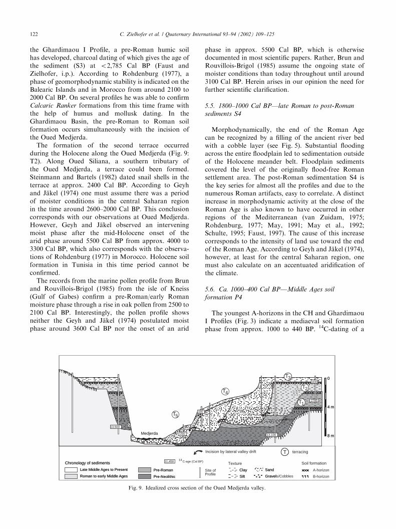
the Ghardimaou I Profile, a pre-Roman humic soilhas developed, charcoal dating of which gives the age ofthe sediment (S3) at o2,785 Cal BP (Faust andZielhofer, i.p.). According to Rohdenburg (1977), aphase of geomorphodynamic stability is indicated on theBalearic Islands and in Morocco from around 2100 to2000 Cal BP. On several profiles he was able to confirmCalcaric Ranker formations from this time frame withthe help of humus and mollusk dating. In theGhardimaou Basin, the pre-Roman to Roman soilformation occurs simultaneously with the incision ofthe Oued Medjerda.
The formation of the second terrace occurredduring the Holocene along the Oued Medjerda (Fig. 9:T2). Along Oued Siliana, a southern tributary ofthe Oued Medjerda, a terrace could been formed.Steinmann and Bartels (1982) dated snail shells in theterrace at approx. 2400 Cal BP. According to Geyhand J.akel (1974) one must assume there was a periodof moister conditions in the central Saharan regionin the time around 2600–2000 Cal BP. This conclusioncorresponds with our observations at Oued Medjerda.However, Geyh and J.akel observed an interveningmoist phase after the mid-Holocene onset of thearid phase around 5500 Cal BP from approx. 4000 to3300 Cal BP, which also corresponds with the observa-tions of Rohdenburg (1977) in Morocco. Holocene soilformation in Tunisia in this time period cannot beconfirmed.
The records from the marine pollen profile from Brunand Rouvillois-Brigol (1985) from the isle of Kneiss(Gulf of Gabes) confirm a pre-Roman/early Romanmoisture phase through a rise in oak pollen from 2500 to2100 Cal BP. Interestingly, the pollen profile showsneither the Geyh and J.akel (1974) postulated moistphase around 3600 Cal BP nor the onset of an arid
phase in approx. 5500 Cal BP, which is otherwisedocumented in most scientific papers. Rather, Brun andRouvillois-Brigol (1985) assume the ongoing state ofmoister conditions than today throughout until around3100 Cal BP. Herein arises in our opinion the need forfurther scientific clarification.
5.5. 1800–1000 Cal BP—late Roman to post-Roman
sediments S4
Morphodynamically, the end of the Roman Agecan be recognized by a filling of the ancient river bedwith a cobble layer (see Fig. 5). Substantial floodingacross the entire floodplain led to sedimentation outsideof the Holocene meander belt. Floodplain sedimentscovered the level of the originally flood-free Romansettlement area. The post-Roman sedimentation S4 isthe key series for almost all the profiles and due to thenumerous Roman artifacts, easy to correlate. A distinctincrease in morphodynamic activity at the close of theRoman Age is also known to have occurred in otherregions of the Mediterranean (van Zuidam, 1975;Rohdenburg, 1977; May, 1991; May et al., 1992;Schulte, 1995; Faust, 1997). The cause of this increasecorresponds to the intensity of land use toward the endof the Roman Age. According to Geyh and J.akel (1974),however, at least for the central Saharan region, onemust also calculate on an accentuated aridification ofthe climate.
5.6. Ca. 1000–400 Cal BP—Middle Ages soil
formation P4
The youngest A-horizons in the CH and GhardimaouI Profiles (Fig. 3) indicate a mediaeval soil formationphase from approx. 1000 to 440 BP. 14C-dating of a
BS
0
4 m
8 m
Late Middle Ages to Present Clay
Roman to early Middle Ages Silt
Pre-Roman Sand
Pre-Neolithic Gravel
Chronology of sediments
Medjerda
T
T3
T1
2
T
0
4 m
8 m
Late Middle Ages to Present Clay A-horizon
Roman to early Middle Ages Silt B-horizon
Pre-Roman SandSite ofProfile
Pre-Neolithic Gravels/Cobbles
Chronology of sediments Texture Soil formation
Medjerda
T
T3
T
T
4
5
T1
2
Incision by lateral valley drift terracing
13,100
13,500
2785
400
100
200
11,450 14 C-age (Cal BP)
Fig. 9. Idealized cross section of the Oued Medjerda valley.
C. Zielhofer et al. / Quaternary International 93–94 (2002) 109–125122

fire-site underlying the youngest layer (S5) yieldedan age of 390 Cal BP (Faust and Zielhofer, i.p.).The Middle Ages soil formation ended no earlierthan this time. Faust et al. (2000) have likewise observeda soil formation phase in Southwest-Spain around1000 Cal BP. They correlate the time of geomorpho-dynamic stability with the corresponding sustainableland use system during the Moorish epoch, moreor less as resulting from a phase of socio-politicalstability. Likewise, soil formation for the Tunisianregion from the time around 1000 to 500 Cal BPwas predicted. Scharpenseel and Zakosek (1979)have dated humic layers on Cape Bon and in theMedjerda valley at Bou Salem at approx. 1000 and 600Cal BP, respectively, although these produced noevidence of in situ soil formation. The Middle Ages soilformation phase P4 in the Ghardimaou Basin againcorresponds to an incision in the valley. The deepeningof the river bed had resulted in a third (T3) Holoceneterrace (see Fig. 9).
5.7. Approx. 400 Cal BP to recent—series S5: Ottoman,
Protectorate Time and Independent Tunisia
At the earliest 400 Cal BP renewed catastrophicflooding began, which led to creation of the final‘‘Youngest Layer’’ (S5) in the whole Ghardimaou Basin.The Youngest Layer is characterized by a fine lamina-tion from silty–clayey to sandy–loamy sediments with-out recognizable soil-forming features. Within theHolocene meander belt the lateral shifting of the Oued
Medjerda continues, with its resulting inner bankterraces (see Fig. 9). The present river bed shows slightaccumulation.
6. Reconstruction of the Holocene water level amplitude
of the Oued Medjerda
Gravel layers indicate the original bottom contourline of the river bed. From there we can temporallyreconstruct the level of the riverbed during the Holoceneof the Oued Medjerda (see Fig. 10). The different soilhorizons imbedded in the sedimentation series indicatephases in which the river only seldom overflowed intothe floodplain. From the difference in level between soiland chronologically corresponding gravel layer, we canreconstruct changes in the flow regime during theHolocene of the Oued Medjerda. Catastrophic floodingcan be observed for the first time in the late Roman Age,associated with a high water level of over 8m (Zielhoferand Faust, i.p.). After the Middle Ages soil formationphase, flooding again increased. High water levels havebeen reconstructed which reached, at least, over the 10mmark.
7. Future research
Further clarification of the genesis of the latePleistocene soil in the Southwest-Mediterranean regionis required. The current status of research, above all in
2,000Cal BP
1,500Cal BP
400Cal BP
2,785Cal BP
Ibéromaurusien
Neolithics
Roman
P S S S SP P P1 2 3 4 52 3 4
?
?
accumulation in the range of meanders
latest Pleistocene terrace level
10 m
0
sedimentation series (S) and soil formation phases (P) in the Ghardimaou Basin
13,500Cal BP
?
recent river bed level
soil formation flood plain sedimentationin the entire Ghardimaou Basin(great flooding)
level of the river bed duringthe Holocenegravel layer
5,500Cal BP
< < << < < < << << <<<
Fig. 10. Water level amplitude of the Oued Medjerda in the Ghardimaou Basin during the Holocene.
C. Zielhofer et al. / Quaternary International 93–94 (2002) 109–125 123

regard to questions about the development intensity andtime frame, remains at this point incomplete and in partscontradictory. Especially, the question of a multi-phasedsoil formation during the early to mid-Holocene is notyet sufficiently clarified. From the 14C-dates currentlyunder analysis, we hope that a clearer chronologicalclarification of the early to mid-Holocene will emerge.
The post-Neolithic sedimentation phase S3 is definedby numerous, lagoon-like still-water sediment layers.These layers are mostly unsuitable for the reconstructionof palaeoclimatic conditions. From the determination ofin situ palygorskite content within the still-waterdeposition, we hope to find proof of an increase in thearidification of the climate in this phase. For finalclarification of questions regarding the morphodynami-cally stable phases and the consequential soil formationswithin the Ghardimaou Basin, further analysis of thinsections is required.
From excursions with our Tunisian colleagues (workgroup Bourgou, University of Tunis) we know thatmorphodynamic activity and soil formation during theHolocene in the catchment area of the Medjerda hasdeveloped differently as in the basin itself. The Crise
Romaine is exhibited in the catchment area throughthick cobble accumulations, whereas in the basin regionno thick sediment layers are to be observed, althoughthere is a clear accentuation of the water level amplitude.Thus it would make sense to widen the research area toinclude the catchment area of the Oued Medjerda.
Acknowledgements
We would like to thank the Deutsche Forschungsge-
meinschaft (DFG) for the financing of this project (FA239/2-2).
References
Borja Barrera, Diaz del Olmo, F., 1994. El acantilado de el Asperillo:
Cuaternario reciente y fases historicas en el litoral de Huelva.
Geogaceta 15, 94–97.
Bourgou, M., 1993. Le bassin-versant du Kebir-Miliane (Tunisie
Nord-orientale). Etude g!eomorphologique. Publications de la
Facult!e de Sciences Humaines et Sociales de Tunis, Tunis, S!erie
II, Vol. 23, p. 435S.
Brun, A., Rouvillois-Brigol, M., 1985. Apport de la Palynologie a
l’Histoire du Peuplement en Tunisie. (ONRS) Palynologie arch-!eologique (II), Paris, pp. 215–226.
Conrad, G., 1969. L’!evolution continentale post-hercynienne du
Sahara Alg!erien (Saoura, Erg Chech-Tanezrouft, Ahnet Mouydir).
Publication Centre National Recherche Scientifique, S!erie
G!eologie, Paris, Vol. 10, 527S.
Coque, R., 1962. La Tunisie Pr!esaharienne. Etude G!eomorpholgique.
Colin, Paris, 476pp.
Diaz del Olmo, F., Borja Barrera, F., Recio Espejo, J.M., RamasMu-
noz, J., 1993. Evolution Pal!eoclimatique au Tardiglaciaire
et "a l’Holoc"ene et pr!esence de l’Homme sur la C #ote "a l’Ouest de
Cadiz (Espagne). Revue de G!eomorphologie Dynamique 42,
81–97.
Faust, D., 1993. Probleme des Ressourcenschutzes in Nordtunesien.
Geomethodica 18, 113–128.
Faust, D., 1995. Erkenntnisse zur holoz.anen Landschaftsentwicklung
in der Campia Niederandalusiens. Geo .okodynamik 16, 153–171.
Faust, D., 1997. Quart.are Landschaftsentwicklung im semiariden
S .udostspanien (Prov. Murcia) und Auswirkungen auf den Agrar-
raum. Die Erde 128, 51–66.
Faust, D., Diaz del Olmo, F., 1997. Pal.aogeographie S .udspaniens in
den letzten 30,000 Jahren: eine Zusammenstellung. Petermanns
Geographische Mitteilungen 141, 279–285.
Faust, D., Diaz del Olmo, F., Baena Escudero, R., 2000. Soils in the
Holocene alluvial sediments of the Rio Fraja Valley, Spain: in situ
or soil-sediments? Catena 41, 133–142.
Faust, D., Zielhofer, C. Reconstruction of the Holocene water level
amplitude of Oued Medjerda as an indicator for changes of the
environmental conditions in northern Tunisia. Zeitschrift f .ur
Geomorphologie N.F., Suppl.-Bd, in press.
Geyh, M., J.akel, D., 1974. Sp.atpleistoz.ane und holoz.ane Klima-
geschichte der Sahara aufgrund zug.anglicher 14C-Daten. Zeitschrift
f .ur Geomorphologie NF 18, 82–98.
May, T., 1991. Morphodynamik und bodenbildungen im westlichen
Mediterranraum seit dem mittleren Holoz.an—Anthropogen oder
klimatisch gesteuert? Theoretische .Uberlegungen und Konkrete
Beispiele. Geographische Zeitschrift 79, 212–229.
May, T., Schumacher, T., M .uller, J., &Kunst, M., 1992. Zur frage
anthropogener Einwirkungen auf die Vegetation im Rahmen der
Neolithisierung des Mediterranraumes. Beispiele aus Ostspanien
und Dalmatien. Die Erde 123, 29–47.
Macklin, M.G., Lewin, J., Woodward, J.C., 1995. Quaternary fluvial
systems in the Mediterranean basin. In: Lewin, J., Macklin, M.G.,
Woodward, J.C. (Eds.), Mediterranean Quaternary River Envir-
onments. Balkema, Rotterdam, pp. 1–25.
Molle, H.G., 1979. Untersuchungen zur Entwicklung der vorzeitlichen
Morphodynamik im Tibesti-Gebirge (Zentralsahara) und in
Tunesien. Berliner Geographische Abhandlungen, Vol. 25, Berlin.
Molle, H.-G., Brosche, K.-U., 1976. Morphologische und klima-
geschichtliche Untersuchungen im s .ud .ostlichen Vorland des Dejbel
Chambi und des Dejbel Mrhila in Zentraltunesien. Die Erde 107,
180–227.
Pachur, H.-J., 1999. Pal.ao-Environment und Drainagesysteme der
Ostsahara im Sp.atpleistoz.an und Holoz.an. In: Klitzsch, E.,
Thorweihe, U. (Eds.), Nordost-Afrika: Strukturen und Ressour-
cen. Wiley-VCH, Weinheim.
Petit-Maire, N., 1994. Natural Variability of the Asien, Indian and
African Monsoons over the last 130 ka. In: Desbois, M.,
D!esalmand, A. (Eds.), Global Precepitation and Climate Change.
NATO ASI Series, 126, Berlin, Heidelberg.
Ramrath, A., Sadori, L., Negendank, F.W., 2000. Sediments from
Lago di Mezzano, central Italy: a record of Lateglacial/Holocene
climatic variations and antropogenic impact. The Holocene 10,
87–95.
Rohdenburg, H., 1977. Neue 14C-Daten aus Marokko und Spanien
und ihre Aussagen f .ur die Relief- und Bodenentwicklung im
Holoz.an und Jungpleistoz.an. Catena 4, 215–228.
Sabelberg, U., 1977. The stratigraphic record of late quaternary
accumulation series in South West Morocco and its consequences
concerning the pluvial hypothesis. Catena 4, 209–214.
Scharpenseel, H.W., Zakosek, H., 1979. Phasen der Bodenbildung in
Tunesien. Zeitschrift f .ur Geomorphologie N.F. Suppl-Bd 33,
118–126.
Schulte, L., 1995. Jungquart.are Flu�dynamik des rio Antas im
zentralen Vera-Becken (SE-Spanien). Geo .okodynamik 16, 173–196.
Steinmann, S., Bartels, G., 1982. Quart.argeomorphologische Beo-
bachtungen aus Nord- und S .udtunesien. Catena 9, 95–108.
C. Zielhofer et al. / Quaternary International 93–94 (2002) 109–125124

Stuiver, M., Reimer, P.J., Bard, E., Beck, J.W., Burr, G.S., Hughen,
K.A., Kromer, B., McCormac, F.G., V.D. Plicht, J., Spurk, M.,
1998. INTCAL98 Radiocarbon Age Calibration, 24,000-0 Cal BP.
Radiocarbon 40, 1041–1083.
Zielhofer, C., Faust, D. Palaeoenvironment, morphodynamics in the
mid-Medjerda floodplain (northern Tunisia) around 13,000 and
2,000 Cal BP. In: Howard, A.J., Macklin, M.G., Passmore, D.G.
(Eds.), The Alluvial Archaeology of North West Europe and the
Mediterranean. Balkema, Rotterdam, in press.
Zuidam, R. A. van 1975. Geomorphology and archaeology. Evidence
of interrelation at historical sites in the Zaragoza region, Spain.
Zeitschrift f .ur Geomorphologie NF 62, 319–328.
C. Zielhofer et al. / Quaternary International 93–94 (2002) 109–125 125