sedimentary processes determining the modern...
TRANSCRIPT

Marine Geology 378 (2016) 213–229
Contents lists available at ScienceDirect
Marine Geology
j ourna l homepage: www.e lsev ie r .com/ locate /margo
Sedimentary processes determining the modern carbonate periplatformdrift of Little Bahama Bank
Ludivine Chabaud a,⁎, Emmanuelle Ducassou a, Elsa Tournadour a, Thierry Mulder a, John J.G. Reijmer b,Gilles Conesa c, Jacques Giraudeau a, Vincent Hanquiez a, Jean Borgomano c, Lauren Ross a
a Université de Bordeaux, UMR CNRS 5805 EPOC, Allée Geoffroy Saint-Hilaire, 33615, Pessac CEDEX, Franceb University Amsterdam, Faculty of Earth and Life Sciences, Sedimentology and Marine Geology Group, De Boelelaan 1085, 1081 HV Amsterdam, The Netherlandsc Aix-Marseille Université, CEREGE UM 34, 3, Pl. Victor Hugo, 13331 Marseille Cedex 3, France
⁎ Corresponding author.E-mail address: [email protected] (L. Ch
http://dx.doi.org/10.1016/j.margeo.2015.11.0060025-3227/© 2015 Elsevier B.V. All rights reserved.
a b s t r a c t
a r t i c l e i n f oArticle history:Received 13 May 2015Received in revised form 6 November 2015Accepted 15 November 2015Available online 21 November 2015
This paper presents an analysis of the combined influence of along-slope sediment transport and off-bank sedi-ment export from the Little Bahama Bank (LBB) to the periplatform sediment wedge of the northwestern part ofthe slope over the last 424 ka. The LBB northwestern slope is divided in (i) a plateau-like structure (margin) at~40 m water depth over at least 4 km parallel to the edge of the LBB; (ii) the uppermost slope with a meanslope angle of ~1.15° from 40 to 300 m water depth; (iii) the upper slope with slope angle of ~0.7 from 300 to650 m water depth, (iv) the middle slope with slope angle of ~1.2, from 650 to 800 m water depth, and(v) the lower slope with slope angle of b~0.5, from 800 to 900 m water depth.The uppermost slope, the upper slope, and the middle slope of the northwestern LBB were characterized byperiplatform oozes that becamemore diluted with pelagic sediment toward the distal part of the slope. This sed-iment distribution of the northwestern LBB slope varied significantly over times according to the flooded surfaceof the LBB. The major flooding periods are related to the highest Relative Sea Level (RSL) (N−6m) that occurredduring interglacial periods, the highest sedimentation rates (10–30 cm/ka) and the finest sediment facies werefound on the slope. During interglacial periods when RSL b −6 m, LBB was emerged but bank margins werestill flooded and correspond to intermediate sedimentation rates (a few to 10 cm/ka) on the slope. Finally, duringglacial periods (RSL b −90 m), LBB was emerged (including its margins), sedimentation rates on the slopedropped to a few mm/ka associated to coarser sediment facies.Off-bank-transported sediment is themain sediment supply during sea-level highstands, occurring preferentiallyduring three major periods of LBB flooding over the last 424 ka: marine isotopic stages 1, 5e and 11. During sea-level lowstands, shallow carbonate production was very low but could develop over a 4 km-wide plateau-likestructure when RSL was above−40 m. The regional Antilles Current affected the sea floor along the northwest-ern LBB slope and influenced coral mound distribution as well as sediment facies and sequences along the upperand middle slopes (300–800 m). During glacial periods, the stronger influence of the Antilles Current upon thealong-slope sedimentation promoted diagenesis via the development of indurated nodules in the upper slope(~400 m water depth). It also encouraged bi-gradational sequences showing a coarsening-up unit followed bya fining-up unit along themiddle slope (~800mwater depth) that is thoroughly bioturbated. The characteristicsof these contourite sequences were similar to those described in siliciclastic environments, but in contrast werecondensed with low sedimentation rates over long (glacial) periods.
© 2015 Elsevier B.V. All rights reserved.
Keywords:Modern carbonate contouritesPeriplatform driftBahamasStratigraphySedimentary recordsQuaternary
1. Introduction
Contourite drifts were first defined as large accumulations of sedi-ment deposited at water depths exceeding 500 m by deep waterbottom-currents circulating over the sea floor related to thermohalinecirculation (Heezen et al., 1966; Heezen and Hollister, 1971; Hollister
abaud).
and Heezen, 1972; Faugères and Stow, 1993). Recently, the term“contourite drift” was also applied to deposits along continental mar-gins built by intermediate (Van Rooij et al., 2010; Rebesco et al., 2013)or shallow (e.g. Vandorpe et al., 2011) water masses. Contourite driftmorphology ranges from small patch drifts (b100 km2) to giant elon-gate drifts (N100,000 km2) (for a complete review see Faugères et al.,1999; Rebesco and Camerlenghi, 2008; Faugères and Mulder, 2011;Rebesco et al., 2014). The relatively continuous accumulation rates ofcontourite drifts (Knutz, 2008) provide a record of paleoenvironmentalchanges throughout time (Hernández-Molina et al., 2003; Llave et al.,

214 L. Chabaud et al. / Marine Geology 378 (2016) 213–229
2006; Voelker et al., 2006; Wilson, 2012, 2013; Toucanne et al., 2012;Mulder et al., 2013; Vandorpe et al., 2014).
Contourite deposits are widely documented in the literature (Stowand Holbrook, 1984; Faugères et al., 1999; Faugères and Stow, 2008;Stow et al., 2002, 2008). However, only few studies have highlightedthe importance of contour-currents along carbonate slopes (Neumannand Ball, 1970; Correa et al., 2012; Betzler et al., 2013; Murdmaa et al.,in this issue ). Five modern carbonate contourite drifts can be found inthe Bahamas: the Pourtales Drift, the Santaren Drift, the Cay Sal Drift,the Great Bahama Bank (GBB) Drift, and the Little Bahama Bank (LBB)Drift (Mullins et al., 1980; Anselmetti et al., 2000; Bergman, 2005;Bergman et al., 2010). The term “periplatform drift”was recently intro-duced (Betzler et al., 2014) to refer to a carbonate slope wedge that isunder the influence of ocean currents. Such periplatform drifts arevery specific compared to other drifts as themain sediment input resultfrom off-bank transport of the carbonate platform located nearby. Theclassical contourite facies is characterized by a bioturbated coarsening-up unit ranging from the muddy facies to silty/sandy facies, followedby a bioturbated fining-up unit ending back with muddy facies. Such afacies succession described from the Faro Drift in the Gulf of Cádiz re-flects the intensification and reduction of current velocities (Gonthieret al., 1984; Faugères et al., 1984). The term “contourite” representsone bigradational sedimentary sequence, and the term “contouritedrift” refers to the staking of contourites forming the sedimentary body.
In carbonate environments, remarkable changes in sedimentationrates have been observed along slopes with a high (low) accumulationof sediment during interglacial (glacial) periods (firstly documented byKier and Pilkey, 1971; Lynts et al., 1973; Mullins et al., 1980; Mullins,1983; Droxler et al., 1983). During sea-level highstands, the completesubmersion of the shallow-water carbonate bank, water depth b6 m, isallowed for the abundant production of fine-grained aragonite particleson the LBB (Neumann and Land, 1975). Production of sediment on thecarbonate bank is sharply reducedwhen the bank top is partially or total-ly emerged during lowstands. Episodic sedimentation due to sea-levelfluctuations between glacial and interglacial periods is explained by the“highstand shedding” model (Droxler and Schlager, 1985; Schlageret al., 1994), which is highlighted in numerous studies (Mullins et al.,1980; Boardman and Neumann, 1984; Boardman et al., 1986; Reijmeret al., 1988; Wilber et al., 1990; Rendle and Reijmer, 2002).
This study analyzed the spatial and temporal variability of sedimen-tation on the LBB Drift (~400 and ~800 m water depth). In addition, itaimed to highlight sedimentary processes at varying distances fromthe bank over the last 424 ka (highstand vs lowstand). A multi-proxyapproach based on bio- and isotopic stratigraphy and sedimentaryanalyses of marine cores was combined with geometrical analyses ofgeophysical data. The aim of this paper is to explain the growth of thiscontourite drift and discuss the use of the term periplatform drift.
2. Present-day environmental setting
2.1. Geological, climatic and oceanographic contexts
The Bahamian archipelago is composed by several shallow-watercarbonate banks (Fig. 1) and has been considered tectonically stablesince the middle Tertiary (Masaferro and Eberli, 1999). It forms an iso-lated platformwith limited wind-derived siliciclastic supply and repre-sents (in maximum) less than 3.4% of the platform sedimentation(Traverse and Ginsburg, 1966; Swart et al., 2014). The Bahamas is now-adays considered as a fairly pure carbonate sedimentation environment.The climate of the northern Bahamas is subtropical to temperate (Rothand Reijmer, 2004) with easterly tradewinds (fromNE, E, and SE)mostof the year and cold northwesterly winds occurring during winter(Sealey, 1994). Wave energy flux is higher on the northern margin ofthe LBB (windward) than the southern and western margins of LBB(leeward) (Hine andNeumann, 1977; Hine et al., 1981a, 1981b). Ocean-ic circulation patterns in the northern Bahamas are complex. However,
it is broadly accepted that the Antilles Current flows to the Northeastalong the Bahama Escarpment and to the North of LBB (Rowe et al.,2015),where itmergeswith the Florida Current to form theGulf Stream(Neumann and Pierson, 1966; Rowe et al., 2015). The only known cur-rent pattern described north of Little Bahama Bank suggests strongercurrents at 400 m water depth than 50 m water depth (Fig. 2, Johns,2011), which is in agreement with highest velocities located in 400 mwater depth to the east of LBB (Lee et al., 1990). Measurements of theAntilles Current taken on the eastern part of the LBB northern slope re-corded flow velocities at 750mwater depth ranging from 0.2 to 0.8 m/sdirected northwest (Costin, 1968). In the same area, a reversal of bot-tom current across the east–west axis was recorded at 1040 m waterdepth but without quantification of the velocities (Gallagher, 1968). Ithas been suggested that the Antilles Current is not a steady flow but be-haves as an eddy field along the Bahamian Archipelago (Gallagher,1968; Ingham, 1974; Gunn andWatt, 1982; Lee et al., 1996). The FloridaCurrent stretches northward from the Straits of Florida to Cape Hatteras(Rowe et al., 2015) with a discharge of 32.1 ± 3.3 Sv (Baringer andLarsen, 2001; Rousset and Beal, 2014). The surface currents are stron-gest on the western side of the straits, above the continental slope offMiami, with maximum velocities exceeding 1.5 to 2 m/s (Brooks andNiiler, 1977). Under this surface current (457 to 825 m water depth),southward-flowing countercurrents are found with average velocitiesof 0.18 m/s, and maximum velocities of 0.6 m/s (Neumann and Ball,1970; Correa et al., 2012). Bottom currents along the eastern side ofthe Bahamas flow to the north at velocities reaching 0.5 m/s at 305 mwater depth (Neumann and Ball, 1970; Neumann et al., 1977).
2.2. Geometry of the LBB Drift
In the Bahamas, the LBB Drift is a modern carbonate contourite driftthat settled along the western side of the northern LBB slope (Mullinset al., 1980). The LBBDrift extends over 100 km(with a slope inclinationaround 1°) and a maximum width of 60 km (Mullins et al., 1980). Ac-cording to the classification of Faugères et al. (1999), the LBB Drift cor-responds to a plastered drift influenced by down-slope processes(Tournadour et al., 2015). The LBB Drift began approximately duringthe Miocene or Pliocene (Unit F in Fig. 3, Tournadour et al., 2015). Ahuge mass transport complex (Tournadour et al., 2015) affected theupper slope of the LBB Drift and the mass transport deposits formed acompressional area on the frontal edge (light blue of Unit F in Fig. 3)which may have been affected by a major erosional event (top of UnitF in Fig. 3). Amajor growthphase occurred during the entire Quaternary(Unit G, in Fig. 3), which is the main focus of this study.
LBB Drift deposits consist of a mixture of planktonic and pelagic mi-crofauna living in thewater column and sediments derived from the ad-jacent LBB (Mullins et al., 1980; Lantzsch et al., 2007), hence a typical“periplatform ooze” (Schlager and James, 1978). Lantzsch et al. (2007)showed, from sediment cores MD99-2202 (Figs. 1, 4A), fine-grainedsediment with a high aragonite content during interglacial periods,and cemented coarser sediment with a high-Mg calcite content duringglacial periods. Hardgrounds are present on the sea floor at approxi-mately 600 to 700 m water depth in the Straits of Florida and, alongthe base of LBB (Neumann and Ball, 1970; Neumann et al., 1977;Mullins andNeumann, 1979). These can be explained bywinnowing re-lated to currents affecting the sea floor (Wilber, 1976), and the diage-netic potential of periplatform oozes (Heath and Mullins, 1984). Bothmechanisms vary in intensity with distance from the edge of the bank(Mullins et al., 1985). Additionally, elongated carbonate mounds(lithoherms) have been observed on the western margin of LBB in theStraits of Florida (Neumann et al., 1977; Messing et al., 1990). Thesemounds were thought to be mainly controlled by currents providingnutrients, and by sea floor topography (Correa et al., 2012). ROV obser-vations revealed that they were occasionally just carbonate blocks witha coral cover (Hebbeln et al., 2012). However, east of the study areadeep carbonate coral mounds (bioherms) have been reported at depths

Fig. 1. A) Location map study area, north of the Bahamas; B) Bathymetric map of carbonate slope located north of LBB (Leg 2 — CARAMBAR cruise). Yellow arrows indicate main oceancurrents. Red points indicate location of marines cores used in this study. Purple dots and line indicate the location of the sound velocity profiles (CARAMBAR 1.5 cruise); C) Zoom onthe LBB Drift. Names of cores are added. Isobaths are drawn after the General Bathymetric Chart of the Oceans (GEBCO, 2014) data set.
215L. Chabaud et al. / Marine Geology 378 (2016) 213–229
of 1000–1300 m water depth with sediment starved ripples inintermound area (Mullins et al., 1981; Reed, 2002).
3. Materials and methods
3.1. Very high-resolution (VHR) seismic data and sedimentary cores
The dataset used in this studywas collected in the LBBDrift along thenorthwest end of the LBB (Fig. 1) during the Carambar Cruise (2010)
Fig. 2. : Currents patterns A) at 50m and B) at 400m obtained during the shipboard ADCP surveC) Sound velocity profiles located on the study area north of LBB (purple dot and lines on Fig.
aboard the R.V. Le Suroît (Mulder et al., 2012a, 2012b) and Carambar1.5 Cruise (2014) on the R.V. F.G. Walton Smith. The MD99-2202 core(Table 1) obtained on the LBBDrift in 1999with theRVMarionDufresnewas added to the dataset (Lantzsch et al., 2007).
All cores (Table 1) were recovered on the westernmost side of thenorthern slope off LBB and penetrated to Unit G, which fills the depres-sion of themass transport complex (Fig. 2). Cores CARKS-18, CARKS-20and CARKS-21 were collected using a Kullenberg piston corer ca 15, 37and 30 km from the bank edge (Fig. 1). Core CARG-28 was collected
y north of Little Bahama Bank, and from the Florida Current section at 27° N (Johns, 2011).1).

Fig. 3. 3D assemblages viewof the seismic interpretation of the LBBDrift (Tournadour et al., 2015). The LBBDrift structured the northwest corner of LBB slope by a hemiconical bodywith adownslope termination at 800 m water depth.
216 L. Chabaud et al. / Marine Geology 378 (2016) 213–229
using a gravity core ca 4 km from the bank edge (Fig. 1). CARG-27 wascollected using a Van Veen grab ca 2 km from the bank edge (Fig. 1).
Approximately 600 km of VHR seismic lines were collected in theLBB Drift from a sub-bottom profiler (Chirp mode). The litho-seismic
Fig. 4. A) Overview of VHR seismic lines 143, 224, 225 and 229 from CARAMBAR cruise and limargin and the name and angles of the different units of the slope are indicated; B) VHR seC) VHR seismic line 143 with various details. Yellow unit corresponds to Unit G described in T
correlation of the cores (CARKS-18, 20 and 21) was made with an aver-age velocity of 1700 m/s (Sheridan et al., 1966; Harwood and Towers,1988). It should be noted that the accuracy of VHR seismic lines is~0.5 ms so ~0.4 m on core sections.
nes 110, 111 and 112 from CARAMBAR 1.5 and an enlargement of core site locations. Theismic line 229 showing the slope morphology and internal sediment wedge structures;ournadour et al. (2015).

Table 1Information of the studied cores including name: the coring method, the length of recovery (cm), the water depth (m water depth), the latitude and the longitude.
Name Coring method Length of recovery (cm) Water depth (m) Latitude Longitude
CARKS-18 Kullenberg piston corer 100 404 27°31.9746′ N 78°59.34813′ WCARKS-20 Kullenberg piston corer 1311 714.2 27°44.66326′ N 78°52.59793′ WCARKS-21 Kullenberg piston corer 1195 798.8 27°40.9360′ N 78°45.0075′ WCARGC-28 Gravity core ~4 191 27°25.179′° N 79°02.881′° WCARG-27 Van Veen grab 7 (indurated block) 68 27°24.116′° N 79°04.213′° WMD99-2202 Calypso Giant Piston Corer 26 460 27°34.45′ N 78°57.93′ W
217L. Chabaud et al. / Marine Geology 378 (2016) 213–229
Sound Velocity profiles were performed along the water columnusing a Minos X vertical profiler at 6 different locations (Fig. 1) inorder to identify water masses (Fig. 2).
3.2. Sedimentological analyses
All sedimentological analyses were performed in the CNRS-EPOCand RAMAT-CRP2A (SEM images) research laboratories of the Universi-ty of Bordeaux. Only a few centimeters of sediment were recoveredfrom CARG-28 and an indurated block was recovered from CARG-27,which prevented sedimentological analyses. The sedimentologicalanalyses of the CARKS-18, CARKS-20, and CARKS-21 cores consisted ofa visual description, photography, and sediment color measurementusing a spectrophotocolorimeter Minolta CM2600D.
X-ray analyses were performed using the SCOPIX X-ray image-processing tool (Migeon et al., 1999). Downcore patterns of strontiumand calcium content were measured every cm in CARKS-18, CARKS-20and CARKS-21 with an Avaatech XRF scanner (10 kV, 400 μA, 10 s, and30 kV 2000 μA, 15 s). Strontium counts were normalized by calciumcounts in order to correct for potential biases associated with the mea-suring method (mainly variations in water content and grain-size).Grain size was measured using a Malvern Mastersizer S laser diffrac-tometer with the Fraunhofer method. The 50th centile (D50 ormedian)and modal distribution of the sediment were used and shown in thecore analysis figures. Four thin sections were collected in core CARKS-21 and in CARKS-18 and the preparation technique used for these sec-tions followed the protocol described in http://www.epoc.u-bordeaux.fr/index.php?lang=fr&page=eq_sedimentologie7 (Zaragosi et al.,2006). Thin section images were then acquired using an automatedLEICA DM6000 B Digital Microscope at ×25 magnifications (Zaragosiet al., 2006). In addition, high-resolution images were made using aScanning Electron Microscopy (SEM) JEOL 6460 LV. Samples of bulksediment were dried and coated with gold for five minutes to ensureconductivity was at an adequate level to use the high vacuummode.
3.3. Biostratigraphical and isotopic analyses
FiveAMS 14C dateswere performed at the Laboratoire duCarbone14(Saclay, France) onmonospecific samples of the planktonic foraminiferaGlobigerinoides ruber var. alba: two on core CARKS-20 over the top60 cm and three on core CARKS-21 over the top 140 cm.
δ18Omeasurementswere carried out at CNRS-EPOC research labora-tory (University of Bordeaux) on ~10 tests of the planktonic foraminiferspecies G. ruber var. alba collected from the 200–250 μm sedimentfraction every 10 cm on CARKS-21 using an Optima Micromass massspectrometer. Data were reported as δ18O versus Pee Dee Belemnitestandard (PDB) after calibration with National Bureau of Standards(NBS) 19 (Coplen, 1988; Hut, 1987).
Coccolith assemblages were investigated at low resolution in orderto validate the AMS 14C and δ18O-based stratigraphical framework ofthe four studied cores. Smear slides were prepared from the fractionb63 μm and examined by means of standard light microscope tech-niques under crossed nicols and polarized light at 1000×magnification.In order to improve the stratigraphic resolution of the Pleistocene inter-val, the biohorizons described for ODP leg 175 (Wefer et al., 1998) wereutilized. This was in addition to the classic first/last occurrences (FO/LO)
of index species, which include dominance intervals of single-species/taxonomical categories.
4. Results
4.1. LBB northern slope morphology and periplatform drift geometry
The LBB northwestern slope becomes a plateau-like structure over4 kmat ~40mwater depth (Fig. 4). The flat plateau-like structure is ori-ented parallel to the edge of the LBB and is considered as its margin.Slope angles divide the slope into different sections: the uppermostslope, the upper slope, themiddle slope, and the lower slope. Theupper-most slope (Rankey andDoolittle, 2012) extends between 40 and 300mwater depth with a mean slope angle of 1.15°, ~3.8° from 40 to 180 mand 0.6° from 180 to 300 m water depth. The upper slope extendsfrom 300 to 650 m water depth with a mean slope angle of ~0.7. Themiddle slope extends from 650 to 800 m water depth with a meanslope angle of ~1.2. Finally, the lower slope extends from 800 to900 m water depth with a mean slope angle b~0.5 (Fig. 4).
The VHR seismic data (lines 110 and 001) of cruise CARAMBAR 1.5showed a very high amplitude signal corresponding to the sea floorand continuous layered sub-bottom reflectors below (Fig. 4). At thebase of the uppermost slope, a surficial acoustically-transparentechofacies related to a low signal penetration was observed down to~400–500 m water depth. This shallow transparent echofacies (in redin Fig. 4) thins basin-wardwith amaximum thickness of 9m at approx-imately 180 m water depth. Below this transparent echofacies, distinctcontinuous and subparallel internal reflectors were observed to 800 mwater depth (in blue in Fig. 4). This unit has been previously describedby Tournadour et al. (2015) as Unit G, which was not part of the LBBDrift according to seismic data (Fig. 3). These authors defined the LBBDrift as restricted to seismic Unit F (Fig. 3). The base of Unit G is definedby a continuous erosional surface associated with punctual moundedtopographies and characterized by hyperbolic echofacies (Fig. 3). Thefrontal and lateral terminations of the LBB Drift (at ~800 m waterdepth) were affected by several submarine slides. The frontal part ofthe periplatform wedge forming the Unit G presents a thickeningwhich suggested the influence of along-slope processes (Fig. 3). Unit Gfills the topographic depressions induced by mass transport complexesand frontal submarine slides and it thins basinwards. Linear incisionsvisible on the sea floor evidence ancient frontal slides in present-daybathymetry that are not completely filled by the sediment of Unit G(Fig. 3).
4.2. Other morphological surface features related to the Antilles Current inthe northern LBB slope
Specific mound-like features also occur on the sea floor of the LBBslope. They are interpreted as coral mounds (overlapping hyperbolesin VHR seismic). Sedimentation surrounding the deep coral moundswas not symmetric along the strike profile and, showed a preferentialaccumulation on the eastern side of the coralmounds (Fig. 4). The pres-ence of coral mounds between 600 and 800 m water depth insisted onthe presence of bottom currents as deep-coral growth requires a regularsupply of nutrients usually brought by these currents (Correa et al.,2012). Moreover, the coral's present spatial distribution is associated
218 L. Chabaud et al. / Marine Geology 378 (2016) 213–229
with the topography. This is because coral mounds are typically locatedon indurated topographic highs (blocks or ridges) that serve as sub-strate for coral larvae settlement (Correa et al., 2012). Distribution ofcoralmounds during the Cenozoic seems related tomajor erosional sur-faces described in Tournadour et al. (2015; Fig. 3). Escarpments relatedto these surfaces would have formed topographic highs that could bepreferentially used as substrate for coral mounds.
The asymmetric sediment accumulation around the coral mounds,namely, non-deposition on the western side of the cold water moundand preferential deposition on the eastern side (Fig. 3), suggestedthat settling of fine-grained particles was driven by bottom currentslocally trapped against escarpments. This induced non-depositionareas behind the coral mounds. These asymmetrical depositional struc-tures are interpreted as “comet-like structures” that resulted fromwestward-orientated bottom currents such as the Antilles Current.Therefore, this provided evidence that the Antilles Current is presentalong the seafloor up to 800 m water depth in the northern LBB slope.
The presence of the Antilles Current in the study area was also evi-denced by 1 to 2 m-long erosional structures on the sea floor orientedin a northwestern direction in the northern lower slope of LBB(Tournadour, 2015). In particular, the presence of sediment starved rip-ples in these intermounded areas east of the study site implied the pres-ence of a strong current (Mullins et al., 1981). During the CARAMBAR1.5 cruise, six sound velocities profiles were collected (only 4 areshown) that suggest the presence of two different water masses: onefrom 0 to 150 m and one from 150 to at least 1000 m water depth,which may be related to the Antilles Current (Fig. 2). This suggestedthat the Antilles Current remobilized the sediment in the eastern partof the north LBB slope, and promoted deposition in the western partof the slope of the LBB Drift.
4.3. Sediment features in the northern LBB slope
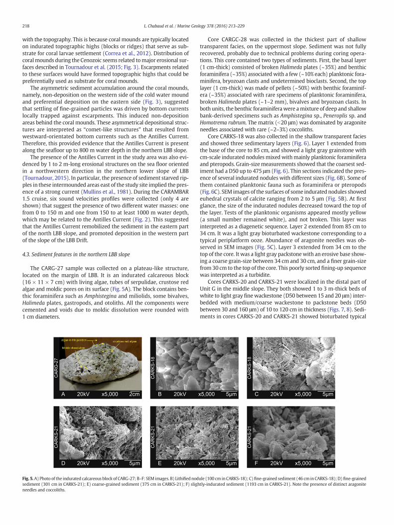
The CARG-27 sample was collected on a plateau-like structure,located on the margin of LBB. It is an indurated calcareous block(16 × 11 × 7 cm) with living algae, tubes of serpulidae, crustose redalgae and moldic pores on its surface (Fig. 5A). The block contains ben-thic foraminifera such as Amphistegina and miliolids, some bivalves,Halimeda plates, gastropods, and otoliths. All the components werecemented and voids due to moldic dissolution were rounded with1 cm diameters.
Fig. 5.A) Photo of the indurated calcareous block of CARG-27; B–F: SEM images. B) Lithified nodsediment (301 cm in CARKS-21); E) coarse-grained sediment (375 cm in CARKS-21); F) slighneedles and coccoliths.
Core CARGC-28 was collected in the thickest part of shallowtransparent facies, on the uppermost slope. Sediment was not fullyrecovered, probably due to technical problems during coring opera-tions. This core contained two types of sediments. First, the basal layer(1 cm-thick) consisted of broken Halimeda plates (~35%) and benthicforaminifera (~35%) associatedwith a few (~10% each) planktonic fora-minifera, bryozoan clasts and undetermined bioclasts. Second, the toplayer (1 cm-thick) was made of pellets (~50%) with benthic foraminif-era (~35%) associated with rare specimens of planktonic foraminifera,broken Halimeda plates (~1–2 mm), bivalves and bryozoan clasts. Inboth units, the benthic foraminiferawere amixture of deep and shallowbank-derived specimens such as Amphistegina sp., Peneroplis sp. andHomotrema rubrum. The matrix (b20 μm) was dominated by aragoniteneedles associated with rare (~2–3%) coccoliths.
Core CARKS-18 was also collected in the shallow transparent faciesand showed three sedimentary layers (Fig. 6). Layer 1 extended fromthe base of the core to 85 cm, and showed a light gray grainstone withcm-scale indurated nodules mixedwithmainly planktonic foraminiferaand pteropods. Grain-sizemeasurements showed that the coarsest sed-iment had a D50 up to 475 μm (Fig. 6). Thin sections indicated the pres-ence of several indurated nodules with different sizes (Fig. 6B). Some ofthem contained planktonic fauna such as foraminifera or pteropods(Fig. 6C). SEM images of the surfaces of some indurated nodules showedeuhedral crystals of calcite ranging from 2 to 5 μm (Fig. 5B). At firstglance, the size of the indurated nodules decreased toward the top ofthe layer. Tests of the planktonic organisms appeared mostly yellow(a small number remained white), and not broken. This layer wasinterpreted as a diagenetic sequence. Layer 2 extended from 85 cm to34 cm. It was a light gray bioturbated wackestone corresponding to atypical periplatform ooze. Abundance of aragonite needles was ob-served in SEM images (Fig. 5C). Layer 3 extended from 34 cm to thetop of the core. It was a light gray packstonewith an erosive base show-ing a coarse grain-size between 34 cm and 30 cm, and a finer grain-sizefrom 30 cm to the top of the core. This poorly sorted fining-up sequencewas interpreted as a turbidite.
Cores CARKS-20 and CARKS-21 were localized in the distal part ofUnit G in the middle slope. They both showed 1 to 3 m-thick beds ofwhite to light gray finewackestone (D50 between 15 and 20 μm) inter-bedded with medium/coarse wackestone to packstone beds (D50between 30 and 160 μm) of 10 to 120 cm in thickness (Figs. 7, 8). Sedi-ments in cores CARKS-20 and CARKS-21 showed bioturbated typical
ule (100 cm in CARKS-18); C)fine-grained sediment (46 cm in CARKS-18); D) fine-grainedtly-indurated sediment (1193 cm in CARKS-21). Note the presence of distinct aragonite

Fig. 6. A) CARKS-18 correlations between CHIRP data in TWS (ms) and lithology, parameter L* and grain-size measurements; B) photo and thin section of the 10-cm grainstone intervaland photo of core CARKS-18; C) enlarged microphoto of one indurated nodule from the thin section taken with a ×25 magnification. Pt: Pteropods, Pf: Planktonic foraminifera.
219L. Chabaud et al. / Marine Geology 378 (2016) 213–229
periplatform ooze sediment with a majority of planktonic foraminifera,pteropods, and a few benthic foraminifera mixed in a carbonate matrixmade of aragonite needles and coccoliths (Figs. 7, 8, 5D, E). Carbonatecontent comprises approximately 90% of the sediment particles exceptin the clay-rich intervals where it reaches 60%. SEM images showed a
Fig. 7. A) Core CARKS-21 correlation between CHIRP data in TWS (ms), lithology, parameter of sof the 15 cm-long interval with wackestone to fine packstone showing a coarsening-up unit foll
high abundance of aragonite needles (2–3 μm long; 0.25 μm width) infine-grained sediment, but a lesser abundance in coarse-grained sedi-ment that showed a higher content of aragonite blades (4–5 μm long;0.45 μmwidth). These aragonite blades were twice aswide as aragoniteneedles (Fig. 5D, E). In both cores CARKS-20 and CARKS-21, the
ediment brightness L* and grain-size median; B) photo, thin section and grain-size modesowed by a fining-up unit. Bioturbations are highlighted by yellow lines on the thin section.

Fig. 8.A)Core CARKS-20 correlation between CHIRP data in TWS (ms), lithology, parameter of sediment brightness L* and grain-sizemedian; B) photo, X-ray images and grain-sizemodesof the 98 cm-long interval of wackestone showing a coarsening-up unit followed by a fining-up unit. Bioturbations are highlighted by yellow lines on X-ray images.
220 L. Chabaud et al. / Marine Geology 378 (2016) 213–229
coarsest-grained beds showed a coarsening-up unit followed by afining-up unit forming a distinct bigradational sequence. In coreCARKS-21, the D50 curve showed coarser sediments over a shorter se-quence than in core CARKS-20, suggesting condensed deposits inCARKS-21. The base of CARKS-21 (~30 cm) was slightly lithified andshowed 2 to 6 μm-long euhedral calcite crystals (Fig. 5F).
4.4. Stratigraphy of the cores
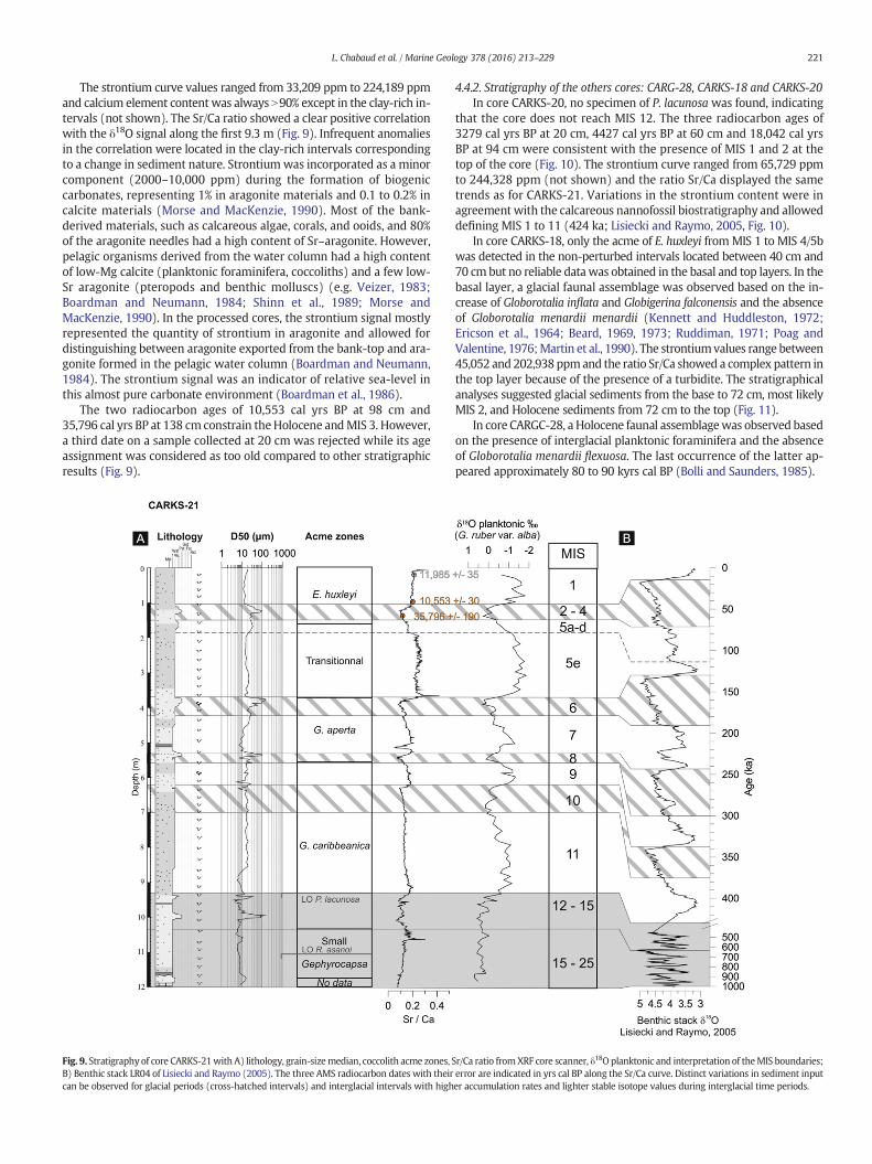
4.4.1. Stratigraphy of the reference core: CARKS-21CARKS-21 was chosen as the reference core because it is the only
core which penetrates through the entire layered drift deposits atits distal fringe (Figs. 3, 4). Calcareous nannofossil biostratigraphyhighlighted the presence of five acme zones: the acme of Emilianiahuxleyi from MIS 1 to MIS 4/5b; the transitional acme of E. huxleyi andGephyrocapsa aperta from MIS 4/5b to the top of MIS 6, the acme ofG. aperta from the top of MIS 6 to the base of MIS 8, the acme ofGephyrocapsa caribbeanica between the bases of MIS 8 and MIS 15,and the acme of small Gephyrocapsa between the bases of MIS 15 andMIS 25. The last occurrences (L.O.) of Pseudoemiliania lacunosa and
Reticulofenestra asanoi, indicate an age of 458 kyrs BP (Thierstein et al.,1977) and 830 kyrs BP (Sato et al., 1991), respectively. From 9.3 m tothe base of the core, the sediments represented ca 500 ka of sedimenta-tion over 2.65 m, so calcareous nannofossil biostratigraphy suggestedlow sedimentation rates (0.5 cm/ka) and/or perturbation.
δ18O values based on G. ruber var. alba tests ranged from −1.86 to0.69‰ (Δ2.55). These values agree with previous results published forthe Bahamas (Droxler et al., 1983; Boardman et al., 1986; Lantzschet al., 2007). The δ18O curve was correlated from the top of the core to9.3mwith the δ18Obenthic stack of Lisiecki andRaymo (2005). However,no correlation was possible with the δ18O benthic stack because the baseof the core to 9.3m showedperturbation and/or low sedimentation rates.
The δ18O curve of CARKS-21presented a slightly different shape thanthe δ18O benthic stack of Lisiecki and Raymo (2005) during MIS 5 andMIS 7. This can be explained by the high variability in sedimentationrates between glacial and interglacial periods. Indeed, the short sea-level lowstand during MIS 7 was likely associated with bioturbatedand condensed deposits making the detection of the δ18O changesdifficult with the chosen sampling resolution step (10 cm intervals be-tween each samples).
221L. Chabaud et al. / Marine Geology 378 (2016) 213–229
The strontium curve values ranged from 33,209 ppm to 224,189 ppmand calcium element content was always N90% except in the clay-rich in-tervals (not shown). The Sr/Ca ratio showed a clear positive correlationwith the δ18O signal along the first 9.3 m (Fig. 9). Infrequent anomaliesin the correlation were located in the clay-rich intervals correspondingto a change in sediment nature. Strontiumwas incorporated as a minorcomponent (2000–10,000 ppm) during the formation of biogeniccarbonates, representing 1% in aragonite materials and 0.1 to 0.2% incalcite materials (Morse and MacKenzie, 1990). Most of the bank-derived materials, such as calcareous algae, corals, and ooids, and 80%of the aragonite needles had a high content of Sr–aragonite. However,pelagic organisms derived from the water column had a high contentof low-Mg calcite (planktonic foraminifera, coccoliths) and a few low-Sr aragonite (pteropods and benthic molluscs) (e.g. Veizer, 1983;Boardman and Neumann, 1984; Shinn et al., 1989; Morse andMacKenzie, 1990). In the processed cores, the strontium signal mostlyrepresented the quantity of strontium in aragonite and allowed fordistinguishing between aragonite exported from the bank-top and ara-gonite formed in the pelagic water column (Boardman and Neumann,1984). The strontium signal was an indicator of relative sea-level inthis almost pure carbonate environment (Boardman et al., 1986).
The two radiocarbon ages of 10,553 cal yrs BP at 98 cm and35,796 cal yrs BP at 138 cm constrain theHolocene andMIS 3. However,a third date on a sample collected at 20 cm was rejected while its ageassignment was considered as too old compared to other stratigraphicresults (Fig. 9).
Fig. 9. Stratigraphy of core CARKS-21with A) lithology, grain-sizemedian, coccolith acme zones, SB) Benthic stack LR04 of Lisiecki and Raymo (2005). The three AMS radiocarbon dates with theircan be observed for glacial periods (cross-hatched intervals) and interglacial intervals with high
4.4.2. Stratigraphy of the others cores: CARG-28, CARKS-18 and CARKS-20In core CARKS-20, no specimen of P. lacunosa was found, indicating
that the core does not reach MIS 12. The three radiocarbon ages of3279 cal yrs BP at 20 cm, 4427 cal yrs BP at 60 cm and 18,042 cal yrsBP at 94 cm were consistent with the presence of MIS 1 and 2 at thetop of the core (Fig. 10). The strontium curve ranged from 65,729 ppmto 244,328 ppm (not shown) and the ratio Sr/Ca displayed the sametrends as for CARKS-21. Variations in the strontium content were inagreement with the calcareous nannofossil biostratigraphy and alloweddefining MIS 1 to 11 (424 ka; Lisiecki and Raymo, 2005, Fig. 10).
In core CARKS-18, only the acme of E. huxleyi fromMIS 1 to MIS 4/5bwas detected in the non-perturbed intervals located between 40 cm and70 cmbut no reliable datawas obtained in the basal and top layers. In thebasal layer, a glacial faunal assemblage was observed based on the in-crease of Globorotalia inflata and Globigerina falconensis and the absenceof Globorotalia menardii menardii (Kennett and Huddleston, 1972;Ericson et al., 1964; Beard, 1969, 1973; Ruddiman, 1971; Poag andValentine, 1976;Martin et al., 1990). The strontiumvalues range between45,052 and 202,938 ppmand the ratio Sr/Ca showed a complex pattern inthe top layer because of the presence of a turbidite. The stratigraphicalanalyses suggested glacial sediments from the base to 72 cm, most likelyMIS 2, and Holocene sediments from 72 cm to the top (Fig. 11).
In core CARGC-28, a Holocene faunal assemblagewas observed basedon the presence of interglacial planktonic foraminifera and the absenceof Globorotalia menardii flexuosa. The last occurrence of the latter ap-peared approximately 80 to 90 kyrs cal BP (Bolli and Saunders, 1985).
r/Ca ratio fromXRF core scanner, δ18O planktonic and interpretation of theMIS boundaries;error are indicated in yrs cal BP along the Sr/Ca curve. Distinct variations in sediment inputer accumulation rates and lighter stable isotope values during interglacial time periods.

Fig. 10. Stratigraphy of core CARKS-20with A) lithology, grain-sizemedian, coccolith acme zones, Sr/Ca ratio fromXRF core scanner and interpretations of MIS boundaries. The three AMSradiocarbon dates with their error are indicated in yrs cal BP along the Sr/Ca curve. Distinct variations in sediment input can be observed for glacial periods (cross-hatched intervals) andinterglacial intervals with higher accumulation rates and lighter stable isotope values during interglacial time periods.
222 L. Chabaud et al. / Marine Geology 378 (2016) 213–229
5. Discussion
5.1. Flooding periods with RSL N −6 m
The LBB lagoon is very shallow (water depth between 1 and 5 m),except in the far northwestern part where the platform top deepens
to 6–12 m. The average water depth of the lagoon is less than 6 m(Williams, 1985). The−6mbathymetric curvewas used in order to de-fine the flooding periods based on RSL curves of Miller et al. (2011) andSiddall et al. (2003; Fig. 12). The last flooding period was the mostconstrained. For example, the limit of 6 m below modern sea levelcorresponded to ~5 cal kyrs BP and 90% of the LBB was flooded around

Fig. 11. Stratigraphy of core CARKS-18 with A) lithology, grain-size median, coccolith acme zone, Sr/Ca ratio from XRF core scanner and interpretations of MIS boundaries. Grainstone in-terval developed from the base to 72 cm likely duringMIS 2 andwackestone to packstone intervals developed from72 cm to the top theHolocene. The ratio Sr/Ca shows a complex patternon the top unit which is related to the turbidite and not to a stratigraphical signal.
223L. Chabaud et al. / Marine Geology 378 (2016) 213–229
4 cal kyrs BP (Droxler et al., 1983). In this study, the basal limit for thelast flooding period given by the 14C age on core CARKS-20 at 60 cm at4.427 ± 30 cal kyrs BP was used.
Throughout the last 424 ka, three major flooding periods exceeding6mwater depthwere defined based on the aforementioned RSL curves.These periods coincidedwith specific time intervals duringMIS 1,MIS 5and MIS 11 (orange areas in Fig. 12). These major flooding periodsmatched those detected in cores GB1 and GB2 on Gran Bahama Island(McNeill et al., 1998) and outcrops on New Providence Island (Aurellet al., 1995). On the margin, an indurated block (CARG-27) was foundon the surface that was not covered by unlithified sediment andwas as-sociated with high amplitude surface reflectors in the seismic profiles(Fig. 4). This suggested that at present limited shallow carbonate sedi-ments had accumulated on this part of the margin and that sedimentcan be easily diagenetized. As only one samplewas taken, it was difficultto generalize this observation. Further, this block could be related toblock failures from the shallower escarpment.
During the threemajor flooding periods, aragonite needles were themain constituent of the sediments along the entirety of the slope withonly a few planktonic organisms present. These included foraminifera,a few pteropods and rare coccoliths. Aragonite needles were likely de-rived from the platform where abundant strontium-rich aragoniteneedles have been observed (Neumann and Land, 1975). The floodingperiods showed sedimentation rates averaging ~17 cm/ka (Table 2)with higher values found in core CARKS-20 (up to ~32 cm/ka duringMIS 5e). These high sedimentation rates observed along the core profilewere related to high carbonate production on the platform (Figs. 13A,14A). Off-bank transport allowed a five to nine times higher accumula-tion (Table 2) of fine-grained carbonate sediment (aragonite needles)over the middle slope (CARKS-20/21) during periods when the bank-top was flooded (12 to 23 cm/ka). This was substantially increase com-pared to when the shallow top is exposed (1 to 4 cm/ka). In addition,aragonite needles were transported off-bank and spread over the entireslope (Fig. 13A). Over the last 424 ka, the three major flooding periodsrepresented a cumulated duration less than 25 ka (4.4 ka, 7 ka and12 ka for MIS 1, MIS 5 andMIS 11, resp.). This indicated that maximumproduction periods of shallow carbonate on the platform correspondedto ca 6% of the time over the last 424 ka.
Off-bank transport processes are often used to explain the sedimen-tation patterns along carbonate slope environments (e.g. Heath andMullins, 1984; Rendle et al., 2000; Rendle-Bühring and Reijmer, 2005;Roth and Reijmer, 2005). On the LBB, present-day off-bank transportof fine sediment occurs preferentially along leeward margins, i.e. onthe west and south sides of LBB (Hine and Neumann, 1977; Hine et al.,1981a, 1981b). Results of this study showed that this off-bank transportwas also significant along the windward margin of LBB. Off-bank trans-port thus corresponded to the sink of sediment-laden mesopycnal andhyperpycnal platform-initiated water flows. These water flows reachtheir density equilibrium depth (i.e. compensation depth), around amaximum of 400–800 m water depth in the Bahamas (Wilson and
Roberts, 1992, 1995). A phenomenon called density cascading, whichincludes an increase in shallow-water bank density (Wilson andRoberts, 1992, 1995) can be triggered in both winter and summermonths. In winter, density cascading is driven by cold fronts(Fernandez-Partegas and Mooers, 1975; Bosart and Schwartz, 1979;Roberts et al., 1982) and in summer by intense heating and evaporationassociatedwith storms (Dill and Steinen, 1988; Shinn et al., 1993).Mon-itoring of sediment traps shows that these dense platform flows canspread easily over 20 km (Hickey et al., 2000), and potentially over50 km (Pilskaln et al., 1989), covering the entire slope of the LBB Drift(Fig. 13A). Fine-grained sediment settles rapidly to the adjacent slopes(Boardman and Neumann, 1984; Pilskaln et al., 1989; Wilson andRoberts, 1992), suggesting acceleration of sediment settling by aggrega-tion with zooplankton fecal pellets (Boardman and Neumann, 1984) ormacro-aggregate formations with aragonite needles (Pilskaln et al.,1989). Bottom currents influence the eastern side of the LBB Drift,allowing the survival of coral mounds, but their influence is limitedduring interglacial periods, preventing winnowing of fine-grained sedi-ment and their dispersion by current over great distances. The high ac-cumulation of periplatform oozes during these maxima of platformflooding prevents circulation of interstitial waters through the sedimentthat is essential for early stages of marine diagenesis commence(Bathurst, 1975).
5.2. Interglacial periods with RSL between−6 m and ca−90 m
During most of the interglacial periods, RSL was not high enough toflood the shallow-platform. However, when RSL was only 40 m lowerthan the present-day sea level, shallow carbonate sediment productionwas restricted to themargin rims of the present LBB (Fig. 13B, 14B). Thenorthwestern margin of LBB is a plateau-like structure located at about−40 m (Fig. 4). This was previously observed in other seismic profilescollected on the western side of the LBB Drift over a width of approxi-mately 4 km (Hine and Neumann, 1977). The presence of Halimedaplates and shallow-water benthic foraminifera in the indurated CARG-27 block suggested shallow-water carbonate production on the marginwhen the platform was exposed. Observations of such induratedblocks with similar components (Halimeda sp.) were observed onthe cemented slope of Tongue of the Ocean (TOTO, Grammer andGinsburg, 1992; Grammer et al., 1993). The components and thesyndepositional cements were dated between 14,000 to 10,500 yearsago by radiocarbonmeasurements (Grammer andGinsburg, 1992), cor-responding to the last interglacial periods before the onset of the majorflooding of MIS 1. Despite the deeper depth of the cemented slope ofTOTO (from ~120/130 at the base of the platform edge wall to 365 mwater depth), this results is consistentwith the hypothesis that produc-tion and cementation occur on the LBB margin (at 20 to 40 m waterdepth) when the shallow-water platform was not flooded.
During these interglacial periods corresponding to an exposed plat-form, sediments observed along the northwestern LBB slope contained

Fig. 12. Log correlation between cores CARKS-18, MD99-2202, CARKS-20, CARKS-21 and relative sea-level curves fromMiller et al. (2011; black curve) and Siddall et al. (2003; red curve).Sedimentation rates (S.R.) are added on the right side of the log for each core. Orange areas indicate flooding periods of LBB; white areas correspond to interglacial periods when LBBwasemerged, and the blue areas are related to the glacial periods. Gray area indicates periodswith low sedimentation rates observed inCARKS-21withoutmajorflooding periods. In the case ofMD99-2202, stratigraphy of MD99-2202 may be biased before MIS 7 due to an erosional surface highlighted in Tournadour et al. (2015) so stratigraphic correlations before MIS 7 werehighlighted by the symbol “?”.
224 L. Chabaud et al. / Marine Geology 378 (2016) 213–229

Table 2Average sedimentation rates (cm/ka) for the different cores through time. It should benoted that sedimentation rates during theflooding periods ofMIS 1may be slightly biasedbecause it is still flooded, and sedimentation in core CARKS-18 has been perturbed by tur-bidity currents (Fig. 3). As MIS 7 and MIS 9 are not flooded during a period enough longand RSL was not enough high, limit between flooding and exposed interglacial periodscould not be separated.
Average sedimentation rates(cm/ka) CARKS-18 MD99-2202 CARKS-20 CARKS-21
Flooding interglacial periods(RSL N 6 m) 16 18 23 12MIS 1 ≥16 ≥7 ≥14 ≥11MIS 5e – 28 32 13MIS 11 – – – 10
>Exposed interglacial periods(90 b RSL b 6 m) 0.5 10 4 3MIS 1 0.5 2 3 6MIS 5a–d – 1 2 0.8MIS 7 – 10 7 2MIS 9 – – 4 2MIS 11 – – – 4
Exposed glacial periods(RSL b 90 m) 0.4 4 1 1MIS 2–4 ≥0.4 3 1 0.7MIS 6 – 2 2 0.9MIS 8 – 2 0.6 0.5MIS 10 – – 1 2
*Indicates values to take with caution. In the case of CARKS-18, because the unit corre-sponding to the MIS 2–4 sediment is not complete, so the sedimentation rate given forthe MIS 2–4 is a minimum. In the case of MD99-2202, stratigraphy of MD99-2202 maybe biased before MIS 7 due to an erosional surface highlighted in Tournadour et al.(2015) so sedimentation values from MIS 8 to MIS 10 are not indicated.
225L. Chabaud et al. / Marine Geology 378 (2016) 213–229
a larger number of planktonic foraminifera and pteropods that weremixed with aragonite needles and coccoliths. The sediment supplywas reduced and sedimentation rates dropped to less than 4 cm/ka onaverage during these interglacial periods. Despite no major floodingduring MIS 7, sedimentation rates for CARKS-20 were similar to thosecalculated for MIS 5 (Table 2). The latter is explained by differences inRSL fluctuations between MIS 5 and MIS 7. During MIS 5, RSL was char-acterized by one long period (~7 ka) with a very high sea level (morethan −6 m) whereas during MIS 7 RSL was potentially characterizedby 3 short periods (~1 ka each) with a high sea level (more than−6 m) according to the RSL curve of Siddall et al. (2003). The RSLcurve of Miller et al. (2011) is different than that of Siddall et al.(2003), however it still suggested that duringMIS 7 a relatively long pe-riod of time (~22 ka) RSL exceeded −40 m. It is likely that the 4 kmwide plateau surrounding parts of LBB has provided a surface largeenough to allow an active shallow carbonate sediment productionthat accumulated on the margin of the LBB during MIS 7. Thisshallow-water carbonate sediment production may be the source ofthe aragonite on the slope during periods of platform exposure(Boardman and Neumann, 1984), such as during MIS 5a–d. The sameobservation could be made for MIS 9 but only in core MD99-2202which showed very high sedimentation rates (~25 cm/ka). It shouldbe noted that stratigraphy of MD99-2202 may be biased before MIS 6because of the presence of an erosion surface (Tournadour et al.,2015). RSL amplitudes during MIS 9 differ between the curve of Milleret al. (2011) and Siddall et al. (2003). Both studies agree that RSLmust have been higher than −40 m for a relatively long period oftime (~25 ka), which could allow shallow carbonate production onthe margin of the LBB (Fig. 13B).
This restricted shallow carbonate sediment production most likelyresulted in a reduced off-bank transport (Fig. 13B). Our study suggestedthat off-bank transport processes are the major sedimentary processesduring these periods although the shallow carbonate production is lim-ited to the plateau-like structure. Mixing between these bank-derivedsediments and planktonic organisms, e.g. planktonic foraminifera,coccoliths and pteropods, explains the type of sedimentation observed(Figs. 13B, 14B). The velocity of the Antilles Currentmay not have varied
drastically throughout the interglacial periods but its current cores(associated with highest velocities) likely deepened as the sea-levelfell (Figs. 13B, 14B).
5.3. Glacial periods with RSL b ca−90 m and contourite sequences
Along the middle slope (~800mwater depth), sediments depositedduring glacial periods corresponded to sediments (wackestone topackstone) coarser than those deposited during interglacial periods(Figs. 7, 8). These results ensured relationship between grain-size vari-ations and glacial-interglacial cyclicity, which has been previously ob-served in cores located on the leeward and windward sides of GBB(Rendle et al., 2000; Rendle-Bühring and Reijmer, 2005). The coarserglacial sediments in both cores were characterized by thoroughlybioturbated sequences showing a coarsening-up unit followed by afining-up unit (Figs. 7, 8). The increase of planktonic foraminifera andpteropods explained the coarsening-up trend of the unit. Fine-grainedparticles (b10 μm) represented less than 30% and sometimes less than20%, and were mainly constituted by coccoliths mixed with aragoniteneedles and blades (Fig. 5E). Sedimentation rates dropped to less than1 cm/ka in the studied cores, forming condensed intervals.
The observed depositional trends corresponded to the bigradationalsequence of contourite defined by Gonthier et al. (1984). These coarse-grained contourites deposited during glacial periods developed as a re-sult of increased winnowing of fine-grained particles by bottom cur-rents (Fig. 13C). This observation suggested the influence of strongerbottom currents at 800 m water depth. This is thought to originatefrom the Antilles Current, which is a wind-driven current that may bestrengthened during glacial periods, similar to what happened in theStraits of Florida (Brunner, 1975). In siliciclastic contourite depositionalsystems, where sedimentation rates during glacial periods were higherthan during interglacial time periods, contourite sequences weredescribed with millennial-scale variability related to the Dansgaard–Oeschger cyclicity (e.g. Llave et al., 2006; Voelker et al., 2006;Toucanne et al., 2012). Themain difference between siliciclastic and car-bonate contourite drifts was that this unique carbonate contouritesequence was very condensed (decimeter to meter scale) with verylow sedimentation rates over the entire glacial period. However, typicaldiagnostic features of contourites such as grain-size distribution or bio-turbation seem to be the same in both carbonate and siliciclasticdeposits.
The contourite sequences were only observed along the middleslope suggesting maximum current velocities at approximately 600–800 m water depth during glacial periods, current velocities that weresufficiently high to sort sediments (Fig. 13C).
On the upper slope, glacial periods were characterized by grainstonedeposition with foraminiferal sand and indurated nodules (i.e.cemented debris). The foraminiferal sand consisted of unbroken testsof planktonic foraminifera and some pteropods. The indurated nodulesconsisted of indurated micrite with hints of planktonic organisms. Thenodules were interpreted as the result of increased carbonate cementa-tion due to early stages of seafloor diagenesis. Similarly, on the westernslope of GBB, well-lithified intervals (i.e. hardgrounds) were found al-most exclusively within glacial intervals, when sedimentation rateswere low, and interpreted to have formed on or close to the seafloor(at 308 and 437 m water depth; Malone et al., 2001). During glacialperiods, the main sediment sources were low-Mg calcite-dominatedsediment producers (e.g. coccoliths, planktonic foraminifera), whichare less prone to early diagenetic processes while calcite is more stablethan aragonite (Bathurst, 1975; Mullins et al., 1985). Hence, the diage-netic potential (Heath and Mullins, 1984) of the periplatform oozewas lower during glacial periods. Early marine cementation was likelyrelated to two processes increasing the porosity of the sediment thatacts simultaneously during glacial periods. First, it is thought that thedecrease of sediment supply, especially fine-grained particles such asthe aragonite needles, is the catalyst to initiate cementation. This

Fig. 13. Schematic diagrams illustrating the three different sedimentation patterns along the LBBperiplatformdrift over the last 450 ka:A)periods ofmajorfloodingof LBBwith RSL around−6 m; shallow-water platform shows full sediment export; B) interglacial periods with partially emerged LBB and RSL around−30 m; shallow-water platform shows limited sedimentexport; and C) glacial periods with emerged LBB and RSL around −120 m; shallow-water platform is exposed and shows no sediment export. Deposit thickness is not to scale, but theyindicate the general trend observed in the accumulation rates.
226 L. Chabaud et al. / Marine Geology 378 (2016) 213–229
carbonate supply decrease is related to the sea-level fall and the reduc-tion of the surface of shallow carbonate production to a narrow part ofthe photosynthetic zone on the uppermost slope. Second, the increaseof the Antilles Current velocity related to the winnowing of the fine-grained sediments during glacial periods should not be downplayed.In both cases, higher porosity and lower sedimentation rates enhancecirculation of interstitialwaters through the sediment allowingmore in-tense chemical, physical and biological reactions to take place that maystimulate cementation, and hence the formation of the induratednodules (Bathurst, 1975).
The margin (b−40mwater depth) was completely exposed duringglacial periods, aswas the entire platform (Figs. 13C, 14C). The presenceof moldic pores on the surface of the indurated block of CARG-27(Fig. 5A) indicated a partial dissolution of it, a process that may occurat a time when the margin was exposed, so most likely during glacialperiods. No data were collected from the uppermost slope coveringthe glacial interval due to bad penetration of CARG-28. However, it issuggested that on the upper slope, hard ground may be formed, similarto the eastern region of the study area (Mullins et al., 1984).
6. Conclusions
Results of this study showed that the sediment wedge of the north-ern LBB slope displayed the characteristics of a periplatform drift. Themodern morphology of the LBB Drift corresponded to a zone affectedby weak currents as described by the model of Betzler et al. (2014).This periplatform drifts was characterized by: 1) the vast input ofcarbonate sediment during highstands in sea-level, which export pref-erentially to the leeward side of the platform and, 2) the merging ofthe Antilles Current with the Florida Current, which shapes thenorthward-plastered contourite drift. However, the influence of thesecurrents was probably limited to sediment redistribution processesduring interglacial periods whereas it reworked the sediments fromthe entire slope during glacial periods. Further investigation is warrant-ed to determine if the term “periplatform drift”may be used in past en-vironment because it is difficult to morphologically highlight theinfluence of the current on the periplatform wedge with seismic tools.
Sedimentation variability along the slope, and through time duringthe last 424 ka showed three main periods: (i) the major flooding of

Fig. 14. Sketch with theoretical extension of shallow carbonate production and sediment deposition on LBB and its west northern slope for: A) flooding interglacial periods withRSL N −6 m; B) interglacial period with RSL around 30 m; and C) glacial periods with RSL N −120 m. Red dots correspond to marines cores used in this study. Isobaths are drawnafter the General Bathymetric Chart of the Oceans (GEBCO, 2014) data set. As their resolution is 112 m, the−40 m isobaths delimit the platform for the margin and is drawn accordingto seismic profiles data (Hine and Neumann, 1977). Red arrows mark the direction of the main ocean currents.
227L. Chabaud et al. / Marine Geology 378 (2016) 213–229
LBB in interglacial periods, (ii) the interglacial periods with the partialemersion of the platform, and (iii) the glacial periods in which the sed-imentation patterns differed in the uppermost (b300 m water depth),the upper (300–650 m water depth), and the middle slopes (650–800 m water depth). These differences in the sedimentation patternswere found to be the following:
1) Off-bank transport was the major sedimentary process during pe-riods of major flooding of LBB. This allowed export of coarse bank-derived organisms and clasts (shallow benthic foraminifera,Halimeda plates, and likely pellets) toward the uppermost slopeand of fine-grained particles (aragonite needles) over larger dis-tances (up to 50 km). This leads to high accumulation rates alongthe entire drift (average ~17 cm/ka). Along the upper and middleslopes, the aragonite needles mixed with planktonic organisms(planktonic foraminifera, coccoliths, and pteropods) to form a typi-cal, fine-grained periplatform ooze.
2) Low sea-level interglacial periods (onset of MIS 1, MIS 5a–d, MIS 7,MIS 9) in which the shallow-water portion of the platform wasemerged, corresponded to limited shallow-water carbonate produc-tion and reduced sediment export toward the slope. When the rela-tive sea level was above−40m present bathymetry, shallow-watercarbonate production was promoted over the 4-km large plateau-like structure and sediment was exported to the slope alongpreferential pathways.
3) Glacial periods and corresponding sea-level lowstands lead to expo-sure of the platform and drastic reduction of shallow-water carbon-ate production. Current-related deposits dominated during glacialperiods along the northern Bahamas slopes over the last 424 ka.Along the upper slope, early marine cementation promoted the for-mation of nodules through mainly a decrease in sediment input andpossibly the winnowing of fine-grained sediments by a strongerglacial Antilles Current. Along the middle slope, the Antilles Currenttransported sufficient nutrients to favor the development along thenorth-western part of LBB slope of cold-water coral mounds atwater depths between 600 and 800m. Between these coralmounds,
the sediments consisted of coarser-grained periplatform oozedeposits that were characterized by thoroughly bioturbatedbigradational sequences with a coarsening-up unit followed by afining-up unit. This typical contourite sequence is known fromsiliciclastic deposits, and resulted from the increased winnowing ofthe fine-grained particles by bottom currents.
Acknowledgments
We wish to thank the captain and crew of the RV Le Suroît for thequality of the acquired data and Ifremer-Genavir for CARAMBAR cruiseorganization. We thank the RSMAS of the University of Miami forCARAMBAR 1.5 cruise organization, and the captain and crew of theWalton Smith for the quality of the acquired data. This study was sup-ported by the French Institut National des Sciences de l'Univers program“ActionMarges” (Contract number: FR00007107).We thank the FrenchArtémis program for radiocarbon measurements. Ludivine Chabaud'sPhD project is supported by a grant from TOTAL E&P (Pau, France).We gratefully acknowledge Pascal Lebleu, Olivier Ther, Béatrice Cossonand Bernard Martin for their technical support during the sedimentanalyses. The authors are grateful to the editor David Van Rooij, theguest editor Andres Rüggeberg and the two anonymous reviewers fortheir valuable comments which greatly improved this manuscript.
References
Anselmetti, F.S., Eberli, G.P., Ding, Z.-D., 2000. From the Great Bahama Bank into the Straitsof Florida: a margin architecture controlled by sea-level fluctuations and oceancurrents. GSA Bull. 112, 829–844.
Aurell, M., McNeill, D.F., Guyomard, T., Kindler, P., 1995. Pleistocene shallowing-upwardsequences in New Providence, Bahamas; signature of high-frequency sea-levelfluctuations in shallow carbonate platforms. J. Sediment. Res. 65, 170–182.
Baringer, M.O.N., Larsen, J.C., 2001. Sixteen years of Florida Current transport at 27° N.Geophys. Res. Lett. 28, 3179–3182.
Bathurst, R.G.C., 1975. Carbonate Sediments and Their Diagenesis. Elsevier, Amsterdam.Beard, J.H., 1969. Pleistocene paleotemperature record based on planktonic foraminifers,
Gulf of Mexico. Trans. Gulf Coast Assoc. Geol. Soc. 26, 185–254.Beard, J.H., 1973. Pleistocene–Holocene boundary,Wisconsinan substages, Gulf of Mexico.
Geol. Soc. Am. Mem. 136, 277–316.

228 L. Chabaud et al. / Marine Geology 378 (2016) 213–229
Bergman, K.L., 2005. Seismic Analysis of Paleocurrent Features in the Florida Straits: In-sights into the Paleocurrent, Upstream Tectonics, and the Atlantic–Caribbean Connec-tion. University of Miami, p. 190.
Bergman, K.L., Hildegard, W., Janson, X., Poiriez, A.E., G.P., 2010. Controlling parameters onfacies geometries of the Bahamas, an isolated carbonate platform environment. In:Westphal, H., Riegl, B., Eberli, G.P. (Eds.), Carbonate Depositional Systems: AssessingDimensions and Controlling Parameters. Springer, Dordrecht, Heidelberg, London,New York (235 pp.).
Betzler, C., Lüdmann, T., Hübscher, C., Fürstenau, J., 2013. Current and sea-level signals inperiplatform ooze (Neogene, Maldives, Indian Ocean). Sediment. Geol. 290, 126–137.
Betzler, C., Lindhorst, S., Eberli, G.P., Lüdmann, T., Möbius, J., Ludwig, J., Schutter, I.,Wunsch,M., Reijmer, J.J.G., Hübscher, C., 2014. Periplatformdrift: the combined resultof contour current and off-bank transport along carbonate platforms. Geology 42,871–874.
Boardman, M.R., Neumann, A.C., 1984. Sources of periplatform carbonates: Norwest Prov-idence Channel, Bahamas. J. Sediment. Petrol. 54, 1110–1123.
Boardman, M.R., Neumann, A.C., Baker, P.A., Dulin, L.A., Kenter, R.J., Hunter, G.E., Kiefer,K.B., 1986. Banktop responses to Quaternary fluctuations in sea level recorded inperiplatform sediments. Geology 14, 28–31.
Bolli, H.M., Saunders, J.B., 1985. Oligocene to Holocene low latitude planktic foraminifera.In: Bolli, H.M., Saunders, J.B., Perch-Nielsen, K. (Eds.), Plankton Stratigraphy.Cambridge University Press, New York, pp. 155–262.
Bosart, L.F., Schwartz, B.E., 1979. Autumnal rainfall climatology of the Bahamas. Mon.Weather Rev. 107, 1663–1672.
Brooks, I.H., Niiler, P.P., 1977. Energetics of the Florida Current. J. Mar. Res. 35, 163–191.Brunner, C.A., 1975. Evidence for intensified bottom current activity in the Straits of
Florida during the last glaciation. Geol. Soc. Am. 7, 1012–1013.Coplen, T.B., 1988. Normalization of oxygen and hydrogen isotope data. Chem. Geol. (Isot.
Geosci. Sect.) 72, 293–297.Correa, T.B.S., Grasmueck, M., Eberli, G.P., Reed, J.K., Verwer, K., Purkis, S.A.M., 2012. Var-
iability of cold-water coral mounds in a high sediment input and tidal current regime,Straits of Florida. Sedimentology 59, 1278–1304.
Costin, J.M., 1968. Direct current measurements in the Antilles Current. J. Geophys. Res.73, 3341–3345.
Dill, R.F., Steinen, R.P., 1988. Deposition of Carbonate mud Beds Within High-EnergySubtidal Sand Dunes, Bahamas.
Droxler, A.W., Schlager, W., 1985. Glacial versus interglacial sedimentation rates and tur-bidite frequency in the Bahamas. Geology 13, 799–802.
Droxler, A.W., Schlager, W., Whallon, C.C., 1983. Quaternary aragonite cycles and oxygen-isotope record in Bahamian carbonate ooze. Geology 11, 235–239.
Ericson, D.B., Ewing, M., Wollin, G., 1964. Pleistocene climates in the Atlantic and Pacificoceans: a comparison based on deep-sea sediments. Science 167, 1483–1485.
Faugères, J.-C., Mulder, T., 2011. Contour currents and contourite drifts. In: Hüneke, H.,Mulder, T. (Eds.), Deep-Sea Sediments. Developments in sedimentology,pp. 149–214.
Faugères, J.-C., Stow, D.A.V., 1993. Bottom-current controlled sedimentation: a synthesisof the contourite problem. 82 (1–4), 287–297. Sediment. Geol. 82, 287–297.
Faugères, J.C., Stow, D.A.V., 2008. Contourite drifts. Nature, evolution and controls. In:Rebesco, M., Camerlenghi, A. (Eds.), Developments in Sedimentology, pp. 259–288.
Faugères, J.C., Gonthier, E., Stow, D.A.V., 1984. Contouritic drift molded by deepMediterranean outflow. Geology 12, 296–300.
Faugères, J.C., Stow, D.A.V., Imbert, P., Viana, A.R., 1999. Seismic features diagnostic ofcontourite drifts. Mar. Geol. 162, 1–38.
Fernandez-Partegas, J., Mooers, C.N.K., 1975. A synoptic study of winter cold fronts inFlorida. Mon. Weather Rev. 103, 742–744.
Gallagher, J.J., 1968. Discussion or paper by J. Michael Costin, 'Direct current measure-ments in the Antilles Current'. J. Geophys. Res. 73, 7148.
GEBCO, 2014. General Bathymetric Chart of the Oceans. http://www.gebco.net/general_interest/faq/.
Gonthier, E.G., Faugères, J.C., Stow, D.A.V., 1984. Contourite Facies of the Faro Drift, Gulf ofCadiz. Geological Society Special Publication, pp. 275–292.
Grammer, G.M., Ginsburg, R.N., 1992. Highstand versus lowstand deposition on carbonateplatform margins: insight from Quaternary foreslopes on the Bahamas. Mar. Geol.103, 125–136.
Grammer, G.M., Ginsburg, R.N., Harris, P.M., 1993. Timing of deposition, diagenesis, and fail-ure of steep carbonate slopes in response to a high-amplitude/high-frequency fluctua-tion in sea level, Tongue of the Ocean, Bahamas. In: Loucks, R.G., F.S.J. (Eds.), CarbonateSequence Stratigraphy: Recent Developments and Applications. AAPG, pp. 107–131.
Gunn, J.T., Watt, D.R., 1982. On the currents and water masses north of the Antilles/Bahamas Arc. J. Mar. Res. 40, 1–48.
Harwood, G.M., Towers, P.A., 1988. Seismic sedimentologic interpretation of a carbonateslope, north margin of Little Bahama Bank. In: Austin, J.A., S.W., et al. (Eds.), Proceed-ing of the Ocean Drilling Program Scientific result. Ocean Drilling Program, CollegeStation, TX, pp. 263–277.
Heath, K.C., Mullins, H.T., 1984. Open-ocean, off-bank transport of fine-grained carbonatesediment in the Northern Bahamas. Geol. Soc. 15, 199–208.
Hebbeln, D., Wienberg, C., participants, a.c., 2012. Report and preliminary results of R/VMaria S. Merian cruise MSM20-4. WACOM, West Atlantic Cold-Water Coral Ecosys-tems: the west side story. Berichte, MARUM – Zentrum für MarineUmweltwissenschaften, Fachbereich Geowissenschaften, Universität Bremen,Bridgetown–Freeport, 14 March – 7 April, 2012, p. 120.
Heezen, B.C., Hollister, C.D., 1971. The Face of the Deep. Oxford University Press, London.Heezen, B.C., Hollister, C.D., Ruddiman,W.F., 1966. Shaping of the continental rise by deep
geostrophic bottom currents. Science 152, 502–508.Hernández-Molina, J., Llave, E., Somoza, L., Fernández-Puga, M.C., Maestro, A., León, R.,
Medialdea, T., Barnolas, A., García, M., del Río, V.D., Fernández-Salas, L.M., Vázquez,
J.T., Lobo, F., Dias, J.M.A., Rodero, J., Gardner, J., 2003. Looking for clues topaleoceanographic imprints: a diagnosis of the Gulf of Cadiz contourite depositionalsystems. Geology 31, 19–22.
Hickey, B.M., MasCready, P., Elliott, E., Kachel, N.B., 2000. Dense saline plumes in ExumaSound, Bahamas. J. Geophys. Res. 105, 471–488.
Hine, A.C., Neumann, A.C., 1977. Shallow carbonate-bank–margin growth and structure,Little Bahama Bank, Bahamas. AAPG Bull. 61, 376–406.
Hine, A.C., Wilber, R.J., Bane, J.M., Neumann, A.C., Lorenson, K.R., 1981a. Offbank transportof carbonate sands along open, leeward bank margins: northern Bahamas. Mar. Geol.42, 327–348.
Hine, A.C.,Wilber, R.J., Neumann, A.C., 1981b. Carbonate sand bodies along constrasting shal-low bank margins facing open seaways in northern Bahamas. AAPG Bull. 65, 261–290.
Hollister, C.D., Heezen, B.C., 1972. Geological effects of ocean bottom currents: westernnorth Atlantic. In: Gordon, A.L. (Ed.), Studies in Physical Oceanography. Gordon andBreach, New York, pp. 37–66.
Hut, G., 1987. In: Gen., R.t.D. (Ed.), Advisory Group Meeting on Stable Isotope ReferenceSamples for Geochemical and Hydrological Investigations. Int. At. Energy Agency,Vienna, p. 42 (16–18 September 1985).
Ingham, C., 1974. Velocity and transport of the Antilles current northeast of the BahamaIslands. Fish. Bull. 73, 626–632.
Johns, B., 2011. Cruise report R/V Knorr Cruise KN-200-4. RAPID/MOCHA Program,pp. 1–14.
Kennett, J.P., Huddleston, P., 1972. Late Pleistocene paleoclimatology, foraminiferal bio-stratigraphy and tephrochronology, western Gulf of Mexico. Quat. Res. 2, 38–69.
Kier, J.S., Pilkey, O., 1971. The influence of sea level changes on sediment carbonate min-eralogy, Tongue of the Ocean, Bahamas. Mar. Geol. 11, 189–200.
Knutz, P.C., 2008. Palaeoceanographic significance of contourite drifts. In: Rebesco, M.,Camerlenghi, A. (Eds.), Contourites. Developments in Sedimentology, pp. 511–535.
Lantzsch, H., Roth, S., Reijmer, J.J.G., Kinkel, H., 2007. Sea-level related resedimentationprocesses on the northern slope of Little Bahama Bank (Middle Pleistocene toHolocene). Sedimentology 54, 1307–1322.
Lee, T.N., Johns, W., Schott, F., Zantopp, R., 1990. Western boundary current structure andvariability east of Abaco, Bahamas at 26.5° N. J. Phys. Oceanogr. 20, 446–466.
Lee, T.N., Johns, W.E., Zantopp, R., 1996. Moored observations of western boundary cur-rent variability and thermohaline circulation 26.5° N in the subtropical north Atlantic.J. Phys. Oceanogr. 26, 962–963.
Lisiecki, L.E., Raymo, M.E., 2005. A Pliocene–Pleistocene stack of 57 globally distributedbenthic d18O records. Paleoceanography 20.
Llave, E., Schönfeld, J., Hernández-Molina, F.J., Mulder, T., Somoza, L., Díaz del Río, V.,Sánchez-Almazo, I., 2006. High-resolution stratigraphy of the Mediterranean outflowcontourite system in the Gulf of Cadiz during the late Pleistocene: the impact ofHeinrich events. Mar. Geol. 227, 241–262.
Lynts, G.W., Judd, J.B., Stehman, C.F., 1973. Late Pleistocene history of Tongue of the Ocean,Bahamas. Geol. Soc. Am. Bull. 84, 2665–2684.
Malone, M.J., Slowey, N.C., Henderson, G.M., 2001. Early diagenesis of shallow-waterperiplatform carbonate sediments, leeward margin, Great Bahama Bank (oceandrilling program leg 166). GSA Bull. 113, 881–894.
Martin, R.E., Johnson, G.W., Neff, E.D., Krantz, D.W., 1990. Quaternary planktonicforaminiferal assemblage zones of the northeast Gulf of Mexico, Colombia basin(Caribbean Sea), and tropical Atlantic Ocean: graphic correlation of microfossil andoxygen isotope datums. Paleoceanography 5, 531–555.
Masaferro, J.L., Eberli, G.P., 1999. Jurassic–Cenozoic structural evolution of the southernGreat Bahama Bank. In: Mann, P. (Ed.), Caribbean Basins: Sedimentary Basins of theWorld, pp. 167–193.
McNeill, D.F., Grammer, G.M., Williams, S.C., 1998. A 5 MY chronology of carbonate plat-form margin aggradation, southwestern Little Bahama Bank, Bahamas. J. Sediment.Res. 68, 603–614.
Messing, C.G., Neumann, A.C., Lang, J.C., 1990. Biozonation of deep-water lithoherms andassociated hardgrounds in the northeastern Straits of Florida. PALAIOS 5, 15–33.
Migeon, S., Weber, O., Faugères, J.-C., Saint-Paul, J., 1999. SCOPIX: a new X-ray imagingsystem for core analysis. Geo-Mar. Lett. 18, 251–255.
Miller, K.G., Mountain, G.S., Wright, J.D., B.J., V., 2011. A 180-million-year record of sealevel and ice volume variations from continental margin and deep-sea isotopic re-cords. Oceanography 24, 40–53.
Morse, J.W., Mackenzie, F.T., 1990. Geochemitry of sedimentary carbonates. Dev.Sedimentol.
Mulder, T., Ducassou, E., Eberli, G.P., Hanquiez, V., Gonthier, E., Kindler, P., Principaud, M.,Fournier, F., Léonide, P., Billeaud, I., Marsset, B., Reijmer, J.J.G., Bondu, C., Joussiaume,R., Pakiades, M., 2012a. New insights into themorphology and sedimentary processesalong the western slope of Great Bahama Bank. Geology 40, 603–606.
Mulder, T., Ducassou, E., Gillet, H., Hanquiez, V., Tournadour, E., Combes, J., Eberli, G.P.,Kindler, P., Gonthier, E., Conesa, G., Robin, C., Sianipar, R., Reijmer, J.J.G., François, A.,2012b. Canyon morphology on a modern carbonate slope of the Bahamas: evidenceof a regional tectonic tilting. Geology 40, 771–774.
Mulder, T., Hassan, R., Ducassou, E., Zaragosi, S., Gonthier, E., Hanquiez, V., Marchès, E.,Toucanne, S., 2013. Contourites in the Gulf of Cadiz: a cautionary note on potentiallyambiguous indicators of bottom current velocity. Geo-Mar. Lett. 33, 357–367.
Mullins, H.T., 1983. Comments and reply on 'Eustatic control of turbidites and winnowedturbidites'. Geology 11, 57–60.
Mullins, H.T., Neumann, A.C., 1979. Deep carbonate bankmargin structure and sedimenta-tion in the northern Bahamas. SEPM Spec. Publ. 7, 165–192.
Mullins, H.T., Neumann, A.C., Wilber, R.J., Hine, A.C., Chinburg, S.J., 1980. Carbonate sedi-ment drifts in northern Straits of Florida. Am. Assoc. Pet. Geol. Bull. 64, 1701–1717.
Mullins, H.T., Newton, C.R., Heath, K., Vanburen, H.M., 1981. Modern deep-water coralmounds north of Little Bahama Bank: criteria for recognition of deep-water coralbioherms in the rock record. J. Sedim. Petrol. 51, 999–1013.

229L. Chabaud et al. / Marine Geology 378 (2016) 213–229
Mullins, H.T., Heath, K.C., Van Buren, H.M., Newton, C.R., 1984. Anatomy of a modernopen-ocean carbonate slope: northern Little Bahama Bank. Sedimentology 31,141–168.
Mullins, H.T., Wise, S.W.J., Gardulski, A.F., Hinchey, E.J., Masters, P.M., Siegel, D.I., 1985.Shallow subsurface diagenesis of Pleistocene periplatform ooze: northern Bahamas.Sedimentology 32, 473–494.
Murdmaa, I., Borisov, D., Ivanova, E., Levchenko, O., Emelyanov, E., Dorokhova, E., Dara, O.,Sivkov, V., 2015. The Ioffe calcareous contourite drift, western south Atlantic. Mar.Geol. (in this issue).
Neumann, A.C., Ball, M.M., 1970. Submersible observations in the Straits of Florida: geol-ogy and bottom currents. Geol. Soc. Am. Bull. 81, 2861–2874.
Neumann, A.C., Land, L., 1975. Lime mud deposition and calcareous algae in the bight ofAbaco, Bahamas: a budget. J. Sediment. Petrol. 45, 763–786.
Neumann, G., Pierson, W.J., 1966. Principles of Physical Oceanography. Prentice-Hall, Inc.,Englewood Cliffs, N.J.
Neumann, A.C., Kofoed, J.W., Keller, G.H., 1977. Lithoherms on the Straits of Florida. Geol-ogy 5, 4–10.
Pilskaln, C.H., Neumann, A.C., Bane, J.M., 1989. Periplatform carbonate flux in the northernBahamas. Deep-Sea Res. 36, 1391–1406.
Poag, C.W., Valentine, P.C., 1976. Biostratigraphy and ecostratigraphy of the Pleistocenebasin, Texas–Louisiana continental shelf. Trans. Gulf Coast Assoc. Geol. Soc. 26,185–254.
Rankey, E.C., Doolittle, F., 2012. Geomorphology of carbonate platform-marginal upper-most slopes: insights from a Holocene analogue, Little Bahama Bank, Bahamas.Sedimentology 59, 2146–2171.
Rebesco, M., Camerlenghi, A., 2008. Contourites. Elsevier.Rebesco, M., Wåhlin, A., Laberg, J.S., Schauer, U., Beszczynska-Möller, A., Lucchi, R.G.,
Noormets, R., Accettella, D., Zarayskaya, Y., Diviacco, P., 2013. Quaternary contouritedrifts of the Western Spitsbergen margin. Deep-Sea Res. I Oceanogr. Res. Pap. 79,156–168.
Rebesco, M., Hernández-Molina, F.J., Van Rooij, D., Wåhlin, A., 2014. Contourites and asso-ciated sediments controlled by deep-water circulation processes: state-of-the-art andfuture considerations. Mar. Geol. 352, 111–154.
Reed, J.K., 2002. Comparison of deep-water coral reefs and lithoherms off southeasternUSA. Hydrobiologia 471, 57–69.
Reijmer, J.J.G., Schlager, W., Droxler, A.W., 1988. Site 632: Pliocene–Pleistocene sedimen-tation in a Bahamian Basin. In: Austin, J.A., Schlager,W., Palmer, A. (Eds.), ProceedingsOcean Drilling Program, Scientific Results. Ocean Drilling Program, College Station,pp. 213–220.
Rendle, R.H., Reijmer, J.J.G., Kroon, D., Henderson, G.M., 2000.Mineralogy and sedimentol-ogy of the Pleistocene to Holocene on the Leeward margin of Great Bahama Bank. In:Swart, P.K., Eberli, G.P., Malone, M.J., Sarg, J.F. (Eds.), Proc. ODP, Sci. Results, 166. Col-lege Station, TX (Ocean Drilling Program), pp. 61–76.
Rendle, R., Reijmer, J.J.G., 2002. Quaternary slope development of the western leewardmargin of the Great Bahama Bank. Mar. Geol. 185, 143–164.
Rendle-Bühring, R.H., Reijmer, J.J.G., 2005. Controls on grain-size patterns in periplatformcarbonates: marginal setting versus glacio-eustacy. Sediment. Geol. 175, 99–113.
Roberts, H.H., Rouse, L.J., Walker, N.D., Hudson, J.H., 1982. Cold-water stress in Florida Bayand northern Bahamas: a product of winter cold-air outbreaks. J. Sediment. Petrol. 52,145–155.
Roth, S., Reijmer, J.J.G., 2004. Holocene Atlantic climate variations deduced from carbonateperiplatform sediments (leewardmargin, Great Bahama Bank). Paleoceanography 19,PA1003.
Roth, S., Reijmer, J.J.G., 2005. Holocenemillennial to centennial carbonate cyclicity record-ed in slope sediments of the Great Bahama Bank and its climatic implications.Sedimentology 52, 161–181.
Rousset, C., Beal, L.M., 2014. Closing the transport budget of the Florida Straits. Geophys.Res. Lett. 41, 1–7.
Rowe, E., Mariano, A.J., Ryan, E.H., 2015. “The Antilles Current” ocean surface currentsWorld wide web article, accessed April 2005. Available online at: http://oceancurrents.rsmas.miami.edu/atlantic/antilles.html.
Ruddiman, W.F., 1971. Pleistocene sedimentation in the equatorial Atlantic: stratigraphyand faunal paleoclimatology. Geol. Soc. Am. Bull. 82, 283–302.
Sato, T., Kameo, K., Takayama, T., 1991. Coccolith biostratigraphy of the Arabian Sea. In:Prell, W.L., Niitsuma, N. (Eds.), Proceeding ODP, Sciences Results. Ocean Drilling Pro-gram, College Station, TX, pp. 37–54.
Schlager, W., James, N.P., 1978. Low-magnesian calcite limestones forming at the deep-sea floor, Tongue of the Ocean, Bahamas. Sedimentology 25, 675–702.
Schlager, W., Reijmer, J.J.G., Droxler, A.W., 1994. Highstand shedding of carbonate plat-forms. J. Sediment. Res. B64, 270–281.
Sealey, N.E., 1994. Bahamian Landscapes: An Introduction to the Geography of theBahamas. Media Publishing, Nassau, Bahamas.
Sheridan, R.E., Drake, C.L., Nafe, J.E., Hennion, J., 1966. Seismic-refraction study ofcontinental margin east of Florida. Bull. Am. Assoc. Pet. Geol. 50, 1972–1991.
Shinn, E.A., Steinen, R.P., Lidz, B., Swart, P.K., 1989. Whitings, a sedimentologic dilemma.J. Sedim. Petrol. 59, 147–161.
Shinn, E.A., Steinen, R.P., Dill, R.F., Major, R., 1993. Lime-mud layers in high-energy tidalchannels: a record of hurricane deposition. Geology 21, 603–606.
Siddall, M., Rohling, E.J., Almongi-Labin, A., Hemleben, C., Meischner, D., Schmeizer, I.,Smeed, D.A., 2003. Sea-level fluctuations during the last glacial cycle. Nature 423,853–858.
Stow, D.A.V., Holbrook, J.A., 1984. North Atlantic contourites: an overview. Geol. Soc.Lond., Spec. Publ. 15, 245–256.
Stow, D.A.V., Pudsey, C.J., Howe, J.A., Faugères, J.-C., Viana, A.R., 2002. Deep-watercontourite systems: modern drifts and ancient series, seismic and sedimentary char-acteristics. Geol. Soc. Lond. Mem. 22, 464.
Stow, D.A.V., Hunter, S., Wilkinson, D., Hernández-Molina, F.J., 2008. The nature ofcontourite deposition. In: Rebesco, M., Camerlenghi, A. (Eds.), Contourites. Develop-ments in Sedimentology, pp. 143–156.
Swart, P.K., Oehlert, A.M., Mackenzie, G.J., Eberli, G.P., Reijmer, J.J.G., 2014. The fertilizationof the Bahamas by Saharan dust: a trigger for carbonate precipitation? Geology 42,671–674.
Thierstein, H.R., Geitzenauer, K.R., Molfino, B., Shackleton, N.J., 1977. Global synchroneityof late Quaternary coccolith datum levels : validation by oxygen isotopes. Geology400-404.
Toucanne, S., Jouet, G., Ducassou, E., Bassetti, M.-A., Dennielou, B., Angue Minto'o, C.M.,Lahmi, M., Touyet, N., Charlier, K., Lericolais, G., Mulder, T., 2012. A 130,000-year re-cord of Levantine intermediate water flow variability in the Corsica Trough, westernMediterranean Sea. Quat. Sci. Rev. 33, 55–73.
Tournadour, E., 2015. Architecure et Dynamique Sédimentaire d'une Pente CarbontéeModerne: Exemple de la Pente Nord de Little Bahama Bank (LBB), Bahamas.Université de Bordeaux, Pessac, p. 282.
Tournadour, E., Mulder, T., Borgomano, J., Hanquiez, V., Ducassou, E., Gillet, H., 2015. Ori-gin and architecture of a mass transport complex on the northwest slope of LittleBahama Bank (Bahamas): relations between off-bank transport, bottom current sed-imentation and submarine landslides. Sediment. Geol. 317, 9–26.
Traverse, A., Ginsburg, R.N., 1966. Palynology of the surface sediments of GreatBahama Bank, as related to water movement and sedimentation. Mar. Geol. 4,417–459.
Van Rooij, D., Iglesias, J., Hernández-Molina, F.J., Ercilla, G., Gomez-Ballesteros, M., Casas,D., Llave, E., De Hauwere, A., Garcia-Gil, S., Acosta, J., Henriet, J.P., 2010. The Le Danoiscontourite depositional system: interactions between the Mediterranean outflowwater and the upper Cantabrian slope (North Iberian margin). Mar. Geol. 274, 1–20.
Vandorpe, T., Van Rooij, D., Stow, D.V., Henriet, J.-P., 2011. Pliocene to recent shallow-water contourite deposits on the shelf and shelf edge off south-western Mallorca,Spain. Geo-Mar. Lett. 31, 391–403.
Vandorpe, T., Van Rooij, D., de Haas, H., 2014. Stratigraphy and paleoceanography of atopography-controlled contourite drift in the Pen Duick area, southern Gulf ofCádiz. Mar. Geol. 349, 136–151.
Veizer, J., 1983. Trace elements and isotopes in sedimentary carbonates. In: Reefer, R.J.(Ed.), Carbonates: Mineralogy and Chemistry. Mineralogical Society of America, Re-views in Mineralogy, Washington, DC, pp. 265–299.
Voelker, A.H.L., Lebreiro, S.M., Schönfeld, J., Cacho, I., Erlenkeuser, H., Abrantes, F., 2006.Mediterranean outflow strengthening during northern hemisphere coolings: a saltsource for the glacial Atlantic? Earth Planet. Sci. Lett. 245, 39–55.
Wefer, G., Berger, W.H., Richter, C., 1998. Ch 2. Explanatory notes — shipboard scientificparty. Proceedings of the Ocean Drilling Program, Initial Reports. 175.
Wilber, R.J., 1976. Petrology of Submarine-Lithified Hardgrounds ans Lithoherms from theDeep Flank Environnement of Little Bahama Bank (Northeastern Straits of Florida).Duke University, Durham, p. 241.
Wilber, R.J., Milliman, J.D., Halley, R.B., 1990. Accumulation of bank-top sediment on thewestern slope of Great Bahama Bank: rapid progradation of a carbonate megabank.Geology 18, 970–974.
Williams, S.C., 1985. Stratigraphy, Facies Evolution and Diagenesis of Late Cenozoic Lime-stones and Dolomites, Little Bahama Bank, Bahamas. Univ. Miami, Coral Gables FL(217 pp.).
Wilson, B., 2012. Percentage carrying capacity in fossil successions: a new ecostratigraphictoolwith potential for detecting palaeoenvironmental change illustrated using bathy-al benthic foraminifera in the Late Quaternary of ODP hole 1006A, Santaren Channel.Palaeogeogr. Palaeoclimatol. Palaeoecol. 337–338, 143–150.
Wilson, B., 2013. Ecostratigraphic regime shift during late Quaternary marine isotopestages 8–9 in Santaren channel, western tropical Atlantic Ocean: benthonic foraminif-eral evidence from ODP hole 1006A. J. Foraminifer. Res. 43, 143–153.
Wilson, P.A., Roberts, H.H., 1992. Carbonate-periplatform sedimentation by density flows:a mechanism for rapid off-bank and vertical transport of shallow-water fines. Geolo-gy 20, 713–716.
Wilson, P.A., Roberts, H.H., 1995. Density cascading: off-shelf sediment transport,evidence and implications, Bahama Banks. J. Sediment. Res. A65, 45–56.
Zaragosi, S., Bourillet, J.-F., Eynaud, F., Toucanne, S., Denhard, B., Van Toer, A., Lanfumey, V.,2006. The impact of the last European deglaciation on the deep-sea turbidite systemsof the Celtic-Armorican margin (Bay of Biscay). Geo-Mar. Lett. 26, 317–329.