sediment generation on a volcanic island with arid ... · of about 100 m2. as the sampling sites...
TRANSCRIPT

lable at ScienceDirect
Applied Geochemistry 75 (2016) 114e124
Contents lists avai
Applied Geochemistry
journal homepage: www.elsevier .com/locate/apgeochem
Sediment generation on a volcanic island with arid tropical climate:A perspective based on geochemical maps of topsoils and streamsediments from Santiago Island, Cape Verde*
Marina M.S. Cabral Pinto a, Pedro A. Dinis b, *, Maria M.V.G. Silva c,Eduardo A. Ferreira da Silva d
a Geobiotec Research Centre and CNC, Department of Earth Sciences, University of Coimbra, 3030-790 Coimbra, Portugalb MARE - Marine and Environmental Sciences Centre, Department of Earth Sciences, 3030-790, Coimbra, Portugalc CEMUC, Department of Earth Sciences, University of Coimbra, 3030-790 Coimbra, Portugald University of Aveiro, Department of Geosciences, Geobiotec Research Centre, 3810-193 Aveiro, Portugal
a r t i c l e i n f o
Article history:Received 1 September 2016Received in revised form20 October 2016Accepted 27 October 2016Available online 31 October 2016
Keywords:Volcanic islandSantiago Island (Cape Verde)TopsoilsBedload stream sedimentsWeatheringErosion
* This paper has been recommended for acceptanc* Corresponding author.
E-mail address: [email protected] (P.A. Dinis).
http://dx.doi.org/10.1016/j.apgeochem.2016.10.0190883-2927/© 2016 Elsevier Ltd. All rights reserved.
a b s t r a c t
The present research tests the application of geochemical atlas of soils and stream sediments in theinvestigation of weathering and erosion processes on volcanic islands. The composition of surface soilscollected in six catchments from Santiago Island (Cape Verde) are compared with bedload stream de-posits sourced by these catchment areas in order to evaluate the spatial variability of these exogenousprocesses. The geochemistry of bedload stream deposits is between that of the fresh rocks and thetopsoils of their source areas. Relative to average soil composition, bedload deposits are depleted in mostof less-mobile elements (e.g., Al, Fe, La, Sc) and strongly enriched in Na and, usually, Ca. When the topsoilweathering intensity in the catchment areas is highly variable and the composition of bedload deposits issubstantially different from the average soil composition, bedload deposits should incorporate significantamounts of poorly-weathered rocks and sectors from erosion occur within the drainage basin. Ratios ofnon-mobile elements allow the identification of highly vulnerable and erosion-protected sectors withinthe catchments. It is proposed that the catchments of the rivers in the SW flanking side of Santiago Islandinclude sectors where lava shields formed during the post-erosional eruptive phases are capable of aneffective protection to erosion. Conversely, the NE-facing part of the island is highly dissected and anyyounger post-erosional cover was either completely eroded away, or never existed in the first place.Simple compositional parameters derived from the databases of geochemical maps of soil and streamsediments provide important information for the analyses of weathering, erosion and denudation pro-cesses at the catchment scale.
© 2016 Elsevier Ltd. All rights reserved.
1. Introduction
Mapping focused on the detection of geochemical anomalieswas initially designed for mineral exploration (Nichol et al., 1966;Levinson, 1974). These maps also provide relevant information onthe natural state of the environment. Thus, geochemical surveysfocused on soil and stream sediment compositions were used in theinvestigations of anthropogenic pollution (Darnley et al., 1995;Plant et al., 2001; Albanese et al., 2007; Cabral Pinto et al., 2012)
e by Prof. M. Kersten.
and medical geology (Reimann et al., 2003; Komatina, 2004; Chenget al., 2008; Cabral Pinto et al., 2014). In view of their application indifferent fields, geochemical atlases of soils and stream sedimenthave been prepared for numerous regions worldwide (Rapant et al.,1999; Lima et al., 2005; Albanese et al., 2007; In�acio et al., 2008; deCaritat and Cooper, 2011; Cabral Pinto, 2010; Rawlins et al., 2012;Martin et al., 2016).
The composition of fluvial deposits is determined by the geologyof the source area and several transformations during the sedimentcycle (sorting, mineral disintegration, transitory weathering etc.)that may shift the final sediment compositions from their parentregolith (e.g., Johnsson, 1993). If the transformations related tohydraulic sorting and mechanical selection are not significant, the

M.M.S. Cabral Pinto et al. / Applied Geochemistry 75 (2016) 114e124 115
composition of fluvial deposits is expected to reflect the averagevolumetric contributions of different geological units within theirdrainage basins (Ingersoll, 1990; Arribas and Tortosa, 2003; Weltje,2012). A combined analysis of fluvial sediments and soils collectedin the respective catchments has the potential of giving relevantinformation about the relative volumetric contribution of detritusderived from different locations within the watersheds. An analysisof the dissolved load, suspended load and bedload, along with acomparison with the composition of the rocks of drainage areas,was applied in studies of the denudation rates and sediment yieldsof volcanic islands (Louvat and All�egre, 1997, 1998; Rad et al., 2006,2007; Nelson et al., 2013). However, as far as we know, data from ageochemical atlas of soil and stream sediments were never used toinvestigate the processes of regolith erosion and sediment gener-ation in these settings. Volcanic islands in semi-arid setting areunder strong erosive stress responsible for soil loss (Tavares andAmiotte-Suchet, 2007; Sanchez-Moreno et al., 2014) and rapiddestruction of the island relief (Menendez et al., 2008; Llanes et al.,2009; Ramalho et al., 2013). The orography of Santiago Island, inparticular, is characterized by its relatively high mountains (up to1392m in elevation), of enhanced rainfall. However, contrary to theother high elevation islands of the Cape Verde Archipelago withjuvenile volcanic relief, Santiago presents dense and deeply incisederosional landforms (Ramalho, 2011). The SW side of the Island andAssomada region, which were rejuvenated by younger post-erosional volcanism, are local exceptions.
Topmost soil samples tend to be enriched in immobile elementswhen compared to average weathering profiles, providing anincomplete perspective of the nature of the regolith (Nesbit andMarkoviks, 1997). On the other hand, bedload stream sedimentsare enriched in mobile elements when compared to the suspendedload (Louvat and All�egre, 1998; Rad et al., 2006) and the soils in thesource area (Rad et al., 2006). Despite the expected differencesbetween topsoils and bedload deposits, an analysis of somegeochemical parameters, such as weathering intensity and immo-bile element ratios, may offer relevant information on the spatialdistribution of sediment generation processes. In the presentresearch we systematically combine the geochemistry of six bed-load stream samples of Santiago Island with the soils collected intheir drainage areas (Fig. 1) in order to investigate: (1) composi-tional changes during sediment generation; and (2) spatial differ-ences in weathering and erosion intensities, associating theirvariability with regions and geological units of the island. Particularattention is paid to the ways of interpreting data from the envi-ronmental geochemical atlas in the analysis of erosional processesand their spatial variability.
2. Geological and geomorphological setting
The Cape Verde Archipelago is a group of ten islands located500 kmwest of Senegals's Cape Verde, on mainlandWestern Africa(Fig. 1A). The archipelago can be sub-divided into a northern chain(Santo Ant~ao, S~ao Vicente, Santa Luzia and S~ao Nicolau islands) andan east-to-southern chain (Sal, Boavista, Maio, Santiago, Fogo andBrava). It is also possible to differentiate the eastern islands of Sal,Boavista and Maio from the remaining islands due to their lowerand flat-lying relief, always below 450 m in elevation, and thepredominance of an erosional landscape (Ramalho, 2011). Incontrast, the western islands reach frequently 1000 m high and theconstructional volcanic landforms are easily discerned. On Santiagoand Santo Ant~ao Islands the overall shield relief is still perceptiblebut the islands are deeply incised by stream valleys.
The Cape Verde Islands are genetically linked with hotspotvolcanism (McNutt, 1988; Sleep, 1990) responsible for the CapeVerde Rise (Lancelot et al., 1978). This volcanic activity started in the
late Oligocene or Early Miocene, being probably older on Sal andBoavista islands (Holm et al., 2008; Ramalho et al., 2010a; 2010b).Geological mapping published by Serralheiro (1976) and the sub-sequent work of Matos Alves et al. (1979) allowed the establish-ment of the volcano-stratigraphy of Santiago Island, whichcomprises, from the oldest to the youngest, the following maingeological units: Ancient Eruptive Complex, Flamengos Formation,Org~aos Formation, Pico da Ant�onia Eruptive Complex, AssomadaFormation, Monte das Vacas Formation and Quaternary sediments.It is possible to identify periods of intense volcanic activityresponsible for the growth of the island alternating with periods oflonger-term volcanic quiescence when erosion and sedimentationwere the dominant processes. The eruptive units can be organizedinto basement, shield-building and post-erosional units accordingto their development within the island's geological history frame-work (Holm et al., 2008; Ramalho et al., 2010a; 2010b).
The Ancient Eruptive Complex constitutes the basement unit ofSantiago Island. Its outcrops are scattered throughout the island,occurring in the valleys where erosion has worn away the mostrecent geological units (Fig. 1B). The largest outcrops occur in thesouthern and central regions of the island. This unit is mostly a dykecomplex with volcanic plugs and intra-volcanic breccias of diversecomposition, including basanitic, basaltic, phonolitic and carbo-natitic (Matos Alves et al., 1979). In general, the rocks of the AncientEruptive Complex are strongly fractured and altered. Several au-thors suggest that fragments of sea-floor basalts (MORB-type)occur within the Ancient Eruptive Complex (Gerlach et al., 1988;Davies et al., 1989), which may indicate an early submarine build-ing with uplifted seafloor (Holm et al., 2008).
The Flamengos Formation and Pico da Ant�onia Complexconstitute the shield-building units on Santiago Island. These unitsare separated by the sedimentary rocks of the Org~aos Formation.The Flamengos Formation occurs essentially in the centre andsouth of Santiago Island, with the widest outcrops being located onthe northeast-facing side of the island. It is formed by a successionof pillow-lavas with subordinated breccias and tuffs. The Pico daAnt�onia Complex is the most extensive outcropping unit of San-tiago Island, corresponding to the main shield-building stage. Thiscomplex is essentially formed by thick sequences of subaerial andsubmarine lava flows intercalated with pyroclastic rocks. Someauthors consider that the unit is composed of a lower member thatseems to be exclusively submarine and an upper member mainlywith subaerial volcanic rocks (Martins et al., 2008; Ramalho et al.,2010b).
The Assomada and Monte das Vacas formations correspond tothe post-erosional units of Santiago Island. Serralheiro (1976)considered that the Assomada Formation is older than the Montedas Vacas Formations, but later radiometric data suggest that theyare coeval (Holm et al., 2008). The Assomada Formation occupies alarge depression between the two largest elevations of the island,Pico da Ant�onia (1392 m) and Serra da Malagueta (1063 m). It isconstituted by basaltic lava flows and pyroclastes, originatedexclusively from sub-aerial activity. The Monte das Vacas Forma-tion is represented by 50 cinder cones of basaltic pyroclastic rocksand associated lava sequences (Johnson et al., 2012). Its constitutingrocks are loosely aggregated and are exploited for constructionmaterials, originating gullies and landslides on the flanks of thevolcanic cones.
3. Materials and methods
The soil and bedload samples database came from the envi-ronmental geochemical atlas of Santiago compiled by Cabral Pinto(2010) for Santiago Island. For each sampling site, compositesamples (~1 kg), made up of five grabs, were collected over an area

Fig. 1. Geological setting of Santiago Island. (A) Location of Santiago Island in the Cape Verde Archipelago and the western Africa shore. (B) Geological map of Santiago Island(modified from Serralheiro, 1976) and location of the soil and bedload sediment samples.
M.M.S. Cabral Pinto et al. / Applied Geochemistry 75 (2016) 114e124116
of about 100 m2. As the sampling sites were selected to representpristine soils and bedload stream sediments, locations near fac-tories or roads with heavy traffic and arable soils were avoided. Thesamples were dried at 35e40 �C, sieved to <2 mm through a plasticsieve, homogenized and quartered. Sub-samples of 50 g each wereobtained and crushed to<75 mm for analysis. The chemical analyseswere performed in the ACME Analytical Laboratories, Ltd (Van-couver, Canada). Each sample was digested in aqua regia and ana-lysed by inductively coupled plasma-mass spectrometry (ICP-MS).Although there is a risk that the digestion with aqua regia did notdestroy all silicates (Darnley et al., 1995), this method is commonlyused in environmental studies and the pattern of distribution ofaqua regia results for many non-mobile elements resemble thoseobtained with total digestion (Ren et al., 2015). The chemical resultswere subjected to several data quality tests in order to determinewhich elements have reliable data for analysis (Cabral Pinto et al.,2015). For this research 6 bedload stream sediments wereselected (10.54, 13.57, 31.58, 93.55, 309.56 and 268A.52; Fig. 1) andthe soils collected within their watersheds (105 samples). The
chemical elements selected for this research are: Al, Ba, Ca, Co, Cr,Cu, Fe, K, La, Mg, Mn, Na, Ni, P, Pb, Sc, Sr, Th, Ti, U, V and Zn. Thedelimitation of the catchment areas that drain to the stream sedi-ment sampling points was performed using a Digital ElevationModel (DEM) based on a Shuttle Radar Topography Mission (SRTM)image with the package Arc Hydro (ArcGIS 10). This softwarepackage was also used to quantify the outcropping areas of themain geological units.
In order to calculate the average soil composition in eachcatchment area (ASC), a weighted average based on the composi-tion of the soils samples collected in each catchment was calculatedaccording to the following equation:
Xi¼ A1�Xi1þA2�Xi2…An�Xin;
where Xi is the average concentration of element i in the topsoils ofthe catchment, A1 to An are the spatial proportions of each litho-logic unit (1 to n) within the watershed and Xi1 to Xin are theaverage concentrations of element i in the topsoils of the each
M.M.S. Cabral Pinto et al. / Applied Geochemistry 75 (2016) 114e124 117
lithologic. Soils collected within a 1 km buffer from the watershedwere also considered.
4. Results and discussion
4.1. Composition of the stream sediments and topsoils in therespective catchments
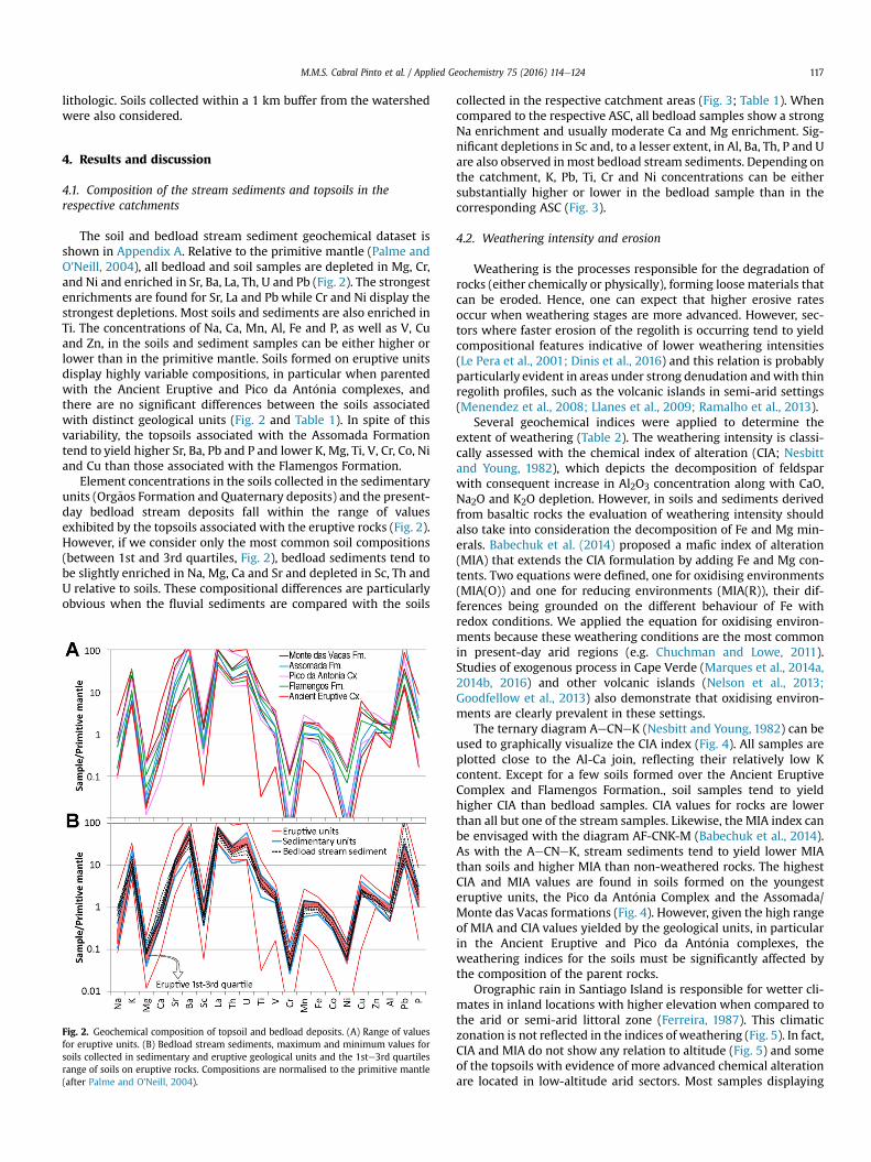
The soil and bedload stream sediment geochemical dataset isshown in Appendix A. Relative to the primitive mantle (Palme andO'Neill, 2004), all bedload and soil samples are depleted in Mg, Cr,and Ni and enriched in Sr, Ba, La, Th, U and Pb (Fig. 2). The strongestenrichments are found for Sr, La and Pb while Cr and Ni display thestrongest depletions. Most soils and sediments are also enriched inTi. The concentrations of Na, Ca, Mn, Al, Fe and P, as well as V, Cuand Zn, in the soils and sediment samples can be either higher orlower than in the primitive mantle. Soils formed on eruptive unitsdisplay highly variable compositions, in particular when parentedwith the Ancient Eruptive and Pico da Ant�onia complexes, andthere are no significant differences between the soils associatedwith distinct geological units (Fig. 2 and Table 1). In spite of thisvariability, the topsoils associated with the Assomada Formationtend to yield higher Sr, Ba, Pb and P and lower K, Mg, Ti, V, Cr, Co, Niand Cu than those associated with the Flamengos Formation.
Element concentrations in the soils collected in the sedimentaryunits (Org~aos Formation and Quaternary deposits) and the present-day bedload stream deposits fall within the range of valuesexhibited by the topsoils associated with the eruptive rocks (Fig. 2).However, if we consider only the most common soil compositions(between 1st and 3rd quartiles, Fig. 2), bedload sediments tend tobe slightly enriched in Na, Mg, Ca and Sr and depleted in Sc, Th andU relative to soils. These compositional differences are particularlyobvious when the fluvial sediments are compared with the soils
Fig. 2. Geochemical composition of topsoil and bedload deposits. (A) Range of valuesfor eruptive units. (B) Bedload stream sediments, maximum and minimum values forsoils collected in sedimentary and eruptive geological units and the 1ste3rd quartilesrange of soils on eruptive rocks. Compositions are normalised to the primitive mantle(after Palme and O'Neill, 2004).
collected in the respective catchment areas (Fig. 3; Table 1). Whencompared to the respective ASC, all bedload samples show a strongNa enrichment and usually moderate Ca and Mg enrichment. Sig-nificant depletions in Sc and, to a lesser extent, in Al, Ba, Th, P and Uare also observed inmost bedload stream sediments. Depending onthe catchment, K, Pb, Ti, Cr and Ni concentrations can be eithersubstantially higher or lower in the bedload sample than in thecorresponding ASC (Fig. 3).
4.2. Weathering intensity and erosion
Weathering is the processes responsible for the degradation ofrocks (either chemically or physically), forming loose materials thatcan be eroded. Hence, one can expect that higher erosive ratesoccur when weathering stages are more advanced. However, sec-tors where faster erosion of the regolith is occurring tend to yieldcompositional features indicative of lower weathering intensities(Le Pera et al., 2001; Dinis et al., 2016) and this relation is probablyparticularly evident in areas under strong denudation andwith thinregolith profiles, such as the volcanic islands in semi-arid settings(Menendez et al., 2008; Llanes et al., 2009; Ramalho et al., 2013).
Several geochemical indices were applied to determine theextent of weathering (Table 2). The weathering intensity is classi-cally assessed with the chemical index of alteration (CIA; Nesbittand Young, 1982), which depicts the decomposition of feldsparwith consequent increase in Al2O3 concentration along with CaO,Na2O and K2O depletion. However, in soils and sediments derivedfrom basaltic rocks the evaluation of weathering intensity shouldalso take into consideration the decomposition of Fe and Mg min-erals. Babechuk et al. (2014) proposed a mafic index of alteration(MIA) that extends the CIA formulation by adding Fe and Mg con-tents. Two equations were defined, one for oxidising environments(MIA(O)) and one for reducing environments (MIA(R)), their dif-ferences being grounded on the different behaviour of Fe withredox conditions. We applied the equation for oxidising environ-ments because these weathering conditions are the most commonin present-day arid regions (e.g. Chuchman and Lowe, 2011).Studies of exogenous process in Cape Verde (Marques et al., 2014a,2014b, 2016) and other volcanic islands (Nelson et al., 2013;Goodfellow et al., 2013) also demonstrate that oxidising environ-ments are clearly prevalent in these settings.
The ternary diagram AeCNeK (Nesbitt and Young, 1982) can beused to graphically visualize the CIA index (Fig. 4). All samples areplotted close to the Al-Ca join, reflecting their relatively low Kcontent. Except for a few soils formed over the Ancient EruptiveComplex and Flamengos Formation., soil samples tend to yieldhigher CIA than bedload samples. CIA values for rocks are lowerthan all but one of the stream samples. Likewise, the MIA index canbe envisaged with the diagram AF-CNK-M (Babechuk et al., 2014).As with the AeCNeK, stream sediments tend to yield lower MIAthan soils and higher MIA than non-weathered rocks. The highestCIA and MIA values are found in soils formed on the youngesteruptive units, the Pico da Ant�onia Complex and the Assomada/Monte das Vacas formations (Fig. 4). However, given the high rangeof MIA and CIA values yielded by the geological units, in particularin the Ancient Eruptive and Pico da Ant�onia complexes, theweathering indices for the soils must be significantly affected bythe composition of the parent rocks.
Orographic rain in Santiago Island is responsible for wetter cli-mates in inland locations with higher elevation when compared tothe arid or semi-arid littoral zone (Ferreira, 1987). This climaticzonation is not reflected in the indices of weathering (Fig. 5). In fact,CIA and MIA do not show any relation to altitude (Fig. 5) and someof the topsoils with evidence of more advanced chemical alterationare located in low-altitude arid sectors. Most samples displaying

Table 1Synthesis of soils and stream sediments compositional data.
Al (%) Ba (ppm) Ca (%) Co (ppm) Cr (ppm) Cu (ppm) Fe (%) K (%) La (ppm) Mg (%) Mn (%) Na (%) Ni (ppm) P (%) Pb (ppm) Sc (ppm) Sr (ppm) Th (ppm) Ti (%) U (ppm) V (ppm) Zn (ppm)
Soils in geological unitsCC Mean 2.57 216.67 1.02 37.57 130.47 58.83 5.61 0.36 33.00 2.00 0.09 0.08 124.07 0.17 3.80 6.73 153.00 2.70 0.42 0.43 150.33 76.33
St.Dev 0.76 95.44 0.26 13.20 68.82 20.85 2.15 0.23 15.62 0.73 0.05 0.03 19.83 0.09 2.01 3.62 9.54 0.82 0.03 0.15 58.77 31.77CB Mean 3.79 220.76 1.07 44.16 126.32 70.06 6.30 0.32 37.04 1.94 0.10 0.05 142.91 0.14 3.25 9.81 166.08 3.52 0.47 0.62 161.88 76.40
St.Dev 0.40 82.85 0.15 5.94 53.23 8.63 0.67 0.09 7.30 0.35 0.02 0.02 36.93 0.05 0.84 2.57 38.24 0.61 0.11 0.19 18.56 8.45MV Mean 5.48 824.57 1.01 44.60 91.30 40.43 8.52 0.27 62.43 2.18 0.15 0.08 131.37 0.14 4.69 10.09 309.86 5.24 0.99 1.04 141.43 81.14
St.Dev 0.75 174.16 0.65 21.56 106.92 26.84 2.33 0.19 6.63 1.65 0.03 0.06 135.21 0.07 1.39 2.94 216.17 1.16 0.40 0.43 56.20 14.85As Mean 4.48 730.60 1.20 21.18 10.40 10.02 6.86 0.18 58.00 0.61 0.15 0.08 14.46 0.23 13.12 7.10 239.80 4.50 0.47 0.78 102.40 97.60
St.Dev 0.31 148.10 0.20 1.44 2.88 2.95 1.04 0.03 6.63 0.09 0.03 0.04 3.09 0.06 11.01 0.60 64.20 0.91 0.14 0.25 20.28 23.28PA Mean 3.99 413.76 0.90 50.04 146.13 51.74 7.19 0.27 47.32 1.79 0.13 0.05 177.12 0.14 5.14 11.45 189.47 4.97 0.55 0.79 161.47 81.62
St.Dev 0.76 162.89 0.35 13.75 80.37 16.25 1.67 0.09 13.34 0.96 0.04 0.03 75.95 0.06 2.20 5.12 117.68 2.39 0.17 0.27 49.61 19.95Fl Mean 3.78 321.25 1.10 46.68 147.91 63.09 6.82 0.51 44.88 1.66 0.12 0.09 150.79 0.14 3.81 9.84 187.13 4.04 0.68 0.80 169.63 92.63
St.Dev 0.63 88.38 0.27 6.58 67.71 15.33 0.79 0.23 14.18 0.36 0.02 0.03 32.66 0.05 0.92 3.51 63.61 0.89 0.15 0.22 30.17 8.88CA Mean 3.66 385.86 1.61 48.08 146.85 69.72 7.12 0.34 53.91 1.60 0.14 0.08 133.11 0.17 5.63 12.47 220.27 5.18 0.37 0.90 188.36 88.55
St.Dev 0.83 155.20 2.18 17.39 70.78 33.59 1.94 0.19 17.87 0.90 0.04 0.14 72.82 0.14 3.58 4.29 229.20 2.72 0.23 0.39 56.51 15.01
Stream sediment and respective catchment10.54 ASC 3.72 520.16 1.88 34.41 85.93 34.96 6.44 0.20 54.97 1.42 0.12 0.07 99.58 0.23 6.17 9.22 291.12 4.60 0.43 0.75 145.46 72.62
SS 2.19 235.00 1.91 32.10 90.00 36.80 5.56 0.26 43.00 1.85 0.09 0.24 120.70 0.22 2.30 4.30 217.00 3.40 0.36 0.60 129.00 78.0013.57 ASC 4.70 546.32 1.06 51.01 146.80 58.71 8.00 0.28 62.41 1.84 0.14 0.06 164.31 0.15 5.93 14.61 252.35 6.05 0.61 0.92 185.14 88.07
SS 3.22 437.00 2.13 53.60 185.40 48.10 7.39 0.24 54.00 3.27 0.12 0.22 254.30 0.17 2.60 7.40 283.00 4.00 0.59 0.70 195.00 96.0031.58 ASC 3.60 436.92 0.83 49.99 158.29 47.27 8.08 0.35 48.60 1.55 0.15 0.05 167.98 0.14 5.32 11.46 132.20 4.63 0.49 0.84 188.29 82.81
SS 2.12 370.00 3.45 33.80 79.00 46.40 5.76 0.44 47.00 1.93 0.10 0.17 118.60 0.22 19.40 4.90 267.00 4.70 0.41 0.70 149.00 100.00309.56 ASC 3.81 302.63 0.90 49.73 166.78 64.24 6.55 0.36 39.45 1.75 0.13 0.05 158.44 0.13 4.87 11.10 179.00 4.48 0.49 0.76 159.63 88.10
SS 3.11 299.50 1.27 43.00 139.15 55.05 6.38 0.29 36.00 2.11 0.11 0.18 164.05 0.16 2.80 6.75 197.00 3.15 0.63 0.50 164.50 79.50268A.52 ASC 3.58 347.95 1.09 47.79 130.64 60.62 6.74 0.27 46.82 1.74 0.13 0.05 164.34 0.16 4.98 9.36 205.60 4.41 0.50 0.88 155.87 84.11
SS 3.05 273.00 1.67 35.60 101.00 54.00 5.41 0.38 39.00 1.69 0.10 0.26 122.00 0.20 8.30 8.00 243.00 3.40 0.38 0.70 136.00 76.0093.55 ASC 3.66 259.74 1.03 48.31 142.57 64.36 6.48 0.32 37.09 2.07 0.11 0.06 175.77 0.13 3.53 9.89 165.32 3.58 0.52 0.59 151.93 79.64
SS 2.96 184.00 1.13 33.40 93.00 53.10 4.74 0.26 31.00 1.63 0.07 0.11 123.90 0.13 3.60 6.80 195.00 2.90 0.47 0.40 125.00 62.00
CC: Quaternary sedimentary units; CB: Org~aos Formation; MV: Monte das Vacas Formation; As: Assomada Formation; PA: Pico da Ant�onia Complex; Fl: Flamengos Formation; CA: Ancient Eruptive Complex; ASC: Average soilcomposition in the catchment area. SS: Stream sediment.
M.M
.S.CabralPinto
etal./
Applied
Geochem
istry75
(2016)114
e124
118

Fig. 3. Average soil composition (ASC; see text for explanation) of the studied catchments normalised to the corresponding bedload stream sediment.
Table 2Weathering indices selected for this work.
Weatheringindex
Formulaa Reference Limitations to the application in Santiago Island
CIA Al2O3/(Al2O3 þ K2O þ Na2O þ CaO)a100 Nesbitt and Young, 1982 Does not considers Fee- and Mg-minerals; values for fresh rock compositionare highly variable; carbonatites with very low values
MIA (Al2O3 þ Fe2O3)/(Al2O3 þ K2O þ Na2O þCaO þ Fe2O3(t) þ MgO)a100
Babechuk et al., 2014 Values for fresh rock composition are highly variable; carbonatites withvery low values
MIA-x (Al2O3 þ Fe2O3(t))/(Al2O3 þ K2O þ Na2O þFe2O3(t) þ MgO)a100
Difference between carbonatites and the remaining rocks is minor, but theoverall variability for fresh rocks is very high
a In molar proportions.
M.M.S. Cabral Pinto et al. / Applied Geochemistry 75 (2016) 114e124 119
strong weathering (CIA>80; MIA>70) were collected in catchmentsof the SW flanking side of Santiago Island (Fig. 5), which could beattributed to a parent-rock control on composition or indicate thatthe slopes on drier leeward side of the island tend to be less affectedby erosion. The bedload stream sediments from the eastern side ofSantiago Island (represented by 268A.52, 93.55 and 309.56) yieldCIA and MIA values not substantially different from the ASC (Fig. 6).The resemblance of the bedload deposits to ASC suggests that thesediment was mostly derived from homogenously shallowweathering profiles. The possibility of an association with shallowregolith is also supported by the relatively low MIA values of ASCwhen compared to the remaining catchments (Fig. 6) and iscompatible with the wider east-facing areas in the region withhigher rainfall (Ferreira, 1987) and risk of erosion (Tavares andAmiotte-Suchet, 2007). Major differences in weathering proxiesbetween the bedload samples and the catchment's average soil arefound for the river that drains southward and westward (repre-sented by 31.58, 13.54 and 10.54). Raised volumes of sediment
generation in restricted locations, including poorly weathered rockfragments, justifies the MIA and CIA values very close to the freshrocks in some bedload deposits (Figs. 5 and 6).
The occurrence of carbonatites in Santiago Island (Serralheiro,1976; Silva et al., 1981) and consequent non-silicate bound CaObrings supplementary difficulties to the application of theseindices. A few soil samples associated with carbonatites of theAncient Eruptive Complex are plotted very close to the CN vertex ofthe A-CN-K diagram and to the CNK-M join of the AF-CNK-M dia-gram due to their high Ca (and Mg) concentrations (Fig. 4). Toensure that the weathering intensities are not biased by the pres-ence of carbonate and phosphate minerals, a modified version ofthe MIA index which does not take CaO content into consideration(MIA-x) is also used. Similar approaches were already adopted forCIA index in sediments with diagenetic carbonate or derived fromcarbonate sedimentary rocks (Garzanti et al., 2014; Dinis et al.,2016). As with CIA and MIA, high MIA-x values are found for top-soils in the catchments of west- and south-draining streams (Figs. 5

Fig. 4. Ternary diagrams Al-Ca þ NaK and Al þ FeeCa þ Na þ KeMg. CIA (Nesbitt and Young, 1982) and MIA (Babechuk et al., 2014) weathering indices are also indicated.Composition of carbonatites from Hoernle et al. (2002); Santiago Island volcanic rocks from Doucelance et al. (2003) and Martins et al. (2010).
M.M.S. Cabral Pinto et al. / Applied Geochemistry 75 (2016) 114e124120
and 6).
4.3. Sediment sources
When compared to the ASC, bedload sediment samples showlower values of weathering intensity and depletion in several ele-ments that tend to be non-mobile, such as Al, Fe, La, Mn, Sc, Th and,except for one catchment, Ti (Fig. 3). Moderate depletion in thestream sediments is also observed for Ba and U. Although Ba tendsto be soluble (e.g. Buggle et al., 2011), its mobility in weatheringprofiles is lower than K (Bouchez et al., 2011; Garzanti et al., 2013;Garzanti and Resentini, 2016) and significant enrichment in basalt-parented regolith can occur (Eggleton et al., 1987; Price et al., 1991).However, due to the low U concentrations in basaltic rocks whencompared to average world dust, abnormal abundance in soils fromvolcanic islands has been associated with dust deposition (Pett-Ridge et al., 2007) and this possibility is particularly plausible inregions like Santiago Island that fall within the Sahara-Sahel dustcorridor (Goudie and Middleton, 2001; Prospero et al., 2002;Dunion and Velden, 2004; Zhang and Pennington, 2004). Localinput of some elements due to human activities can also beconsidered. For example, the highly variable Pb and P contents maybe partially related to human activities. In conclusion, bedloaddeposits represent an intermediate composition between twoendmembers: the non-weathered rock (which tends to be enrichedin mobile elements) and the more weathered topsoil (which tendsto be enriched in non-mobile elements and may incorporate allo-genic material associated with the deposition of atmospheric dustor introduced by human activities). The proportion of the twoendmembers in a given bedload deposit should reflect the spatialdistribution of weathering and erosion processes in the catchmentarea.
As weathering state is expected to influence the concentrationof both mobile elements and non-mobile elements, an analysis ofthe nature of the source units based on soils and sediment com-positions must consider a combination of non-mobile elements.Ternary plots La-Co-Cr and La-Th-Ti were selected for this
provenance analysis because the elements involved do not showmajor differences in bedload concentration relative to ASC (Fig. 3).These ternary plots isolate several soil samples from the bedloadsamples and the remaining soils of the respective catchment(Fig. 7). The immobile elements that are either enriched or depletedin the bedload samples with respect to the corresponding catch-ment ASC, such as Co and Cr (Fig. 3), can also be applied to identifysource areas that are supplying anomalously high or low sedimentyields. Soils of Santiago Island with higher Cr and Co abundancestend to be associated with mafic volcanic rocks (Marques et al.,2012; Cabral Pinto et al., 2015) and the enrichment in these ele-ments in bedload stream sediments relative to the ASC (samples10.54 and 13.57; Fig. 3) points to increased supply from mafic-derived soils (Fig. 7). Hence, soil samples belonging to the catch-ment areas of samples 10.54 and 13.57 that are isolated in the La-Co-Cr and La-Th-Ti plots (Fig. 7) probably came from sectors thathave contributed low volumes of sediment. The relatively high CIA,MIA and MIA-x weathering indices yielded by most of these soilsamples (Fig. 5) reinforce the hypothesis that they correspond tolocations protected from erosional processes. The majority of thesesoil samples are parented with the Assomada Formation. Incontrast, “uncharacteristic” La-rich and Ti-poor samples collectedin the catchment area of 31.58 probably have correspondence withsectors strongly affected by erosion, explaining the differencesbetween the ASC and bedload sediment compositions (Fig. 7).
4.4. Implications for the interpretation of Santiago Islanddenudation
The topsoil and bedload stream samples can also be applied inthe interpretation of the longer-term denudation. Non-weatheredlava surfaces have a crucial role in the protection from coastaland fluvial erosion (Ramalho et al., 2013),. The advanced weath-ering of the shield building units may have promoted local failure ofthe protection to erosion, being the more elevated areas of the is-land, where rainfall erosivity is high (Sanchez-Moreno et al., 2014)and climatic conditions favour weathering progress, particularly

Fig. 5. Values of CIA (Nesbitt and Young, 1982), MIA (Babechuk et al., 2014) and the modified version of MIA without Cao (MIA-x; see text for explanation) weathering indices fortopsoils with location in Santiago Island. Santiago Island carbonatites (from Hoernle et al., 2002) and volcanics rocks (from Doucelance et al., 2003; Martins et al., 2010) arerepresented for comparison. M.V.-As. Fms.: Monte das Vacas-Assomada formations; P.A. Cx.: Pico da Ant�onia Complex; Fl. Fm.: Flamengos Formation; A.E. Cx.: Ancient EruptiveComplex. Key for geological map in Fig. 1.
M.M.S. Cabral Pinto et al. / Applied Geochemistry 75 (2016) 114e124 121
affected by the erosional processes. The exhumation of large out-crops of the Ancient Eruptive Complex in relatively high elevations(ca. 200e650 m) at the centre of the island reflects the advance ofSantiago Island's denudation.
The asymmetry between the SW- and NE-facing sides of San-tiago Island is partially attributed to different stages of the denu-dation process. Although the geomorphic evolution of oceanicislands largely depends on the degree of development of drainagenetworks, the morphology of the drier leeward flank of the island(i.e., the SW side that is less affected by erosion) seems to reflect theyounger post-erosional rejuvenation of the landscape by extensivelava shields of the Assomada and Monte das Vacas formations(Johnson et al., 2012). In the NE-facing side of the island, thecapping rocks of the Pico da Ant�onia Complex are deeply incised bynumerous streams that exhumed the Org~aos and Flamengos for-mations and can reach the Ancient Eruptive Complex. Bedload
stream sediments in this part of the island (represented by268A.52, 93.55 and 309.56) are mainly sourced by the weatheringprofiles, with a minor contribution of poorly-weathered rocks,explaining the similarities between bedload deposits and ASCcompositions (Figs. 3, 6 and 7).
The rocks of the Pico da Ant�onia Complex still constitute aneffective barrier to the progress of erosion in places of low elevationwhere weathering and rainfall are less intense, namely in the caseof the rivers with south drainage (represented by samples 31.58and 13.57). Where the fluvial incision reaches the highly alteredAncient Eruptive Complex it is expected that it will progress swiftlyupstream, promoting the island's denudation. Rapid dismantling ofthis unit justifies the very low values of MIA and CIA in the bedloadsamples, in particular in 31.58 (Fig. 6). The Assomada Formation in awest-draining stream (represented by 10.54) constitutes a youngererosion-resisting cap formed during the post-erosional volcanic

Fig. 6. Comparison of CIA, MIA and MIA-x weathering intensities in bedload depositswith the catchment's average soil composition (ASC).
Fig. 7. Ternary diagrams LaeCoeCr and LaeTheTi for the samples collected in each catchmFig. 1 and 4, respectively.
M.M.S. Cabral Pinto et al. / Applied Geochemistry 75 (2016) 114e124122
phase, as demonstrated by the ratios of non-mobile elements(Fig. 7) and the weathering intensity indices in topsoil samples(Fig. 5), which indicate that minor amounts of detritus are suppliedby the regolith sequences that rest on this geological unit. Thepresence of preserved plateaus in the southern andwestern sides ofthe island, contrasting with the more dissected NE side (Marques,1990), reinforces this possibility. Regardless of its nature, whenpost-erosional volcanic landscape rejuvenation is more extensive,bedload stream deposits should include a significant proportion ofpoorly-weathered rocks. Under these conditions, the compositionof the topsoils is more variable and major differences betweenbedload stream deposits and the topsoils in the catchment areasare expected.
5. Conclusions
The composition of bedload stream deposits is somewhere be-tween that of the fresh rocks (usually enriched in mobile elements)and the topsoils (usually enriched in non-mobile elements) of theirdrainage areas and may be either closer to non-weathered rocks orto the surface soils. This fact raises a fundamental difficulty in theapplication of the composition of surface soils and bedload depositsin the analysis of differential detritus supply from distinct regionswithin a catchment. The geochemical atlases of surface soils andbedload stream sediments provide valuable information about theweathering/erosion processes at the catchment scale and theirspatial variability, despite not being designed for these purposesand not routinely account for the numerous factors that control
ent and corresponding bedload deposit. Geological map and samples symbols keys in

M.M.S. Cabral Pinto et al. / Applied Geochemistry 75 (2016) 114e124 123
sediment composition (e.g., sorting processes, mineral breakdown,transformation during transitory deposition, etc.).
Where the average topsoil compositions are substantiallydifferent from bedload deposits and the variability of topsoilweathering intensity is high, bedload deposits should incorporatesignificant amounts of poorly-weathered rocks fragments. In thesecases the erosion within the drainage basin is expected to varyspatially, with highly vulnerable and erosion-protected sectors.Ratios of non-mobile elements for the soils of the drainage basinhelp to identify the geological units and areas where erosion in thecatchment is lower/higher. In contrast, a more similar compositionof surface soils and bedload sediments, both with lower weatheringintensities, suggests more widespread and homogeneouslydistributed erosion. This approach based on geochemical maps oftopsoil and bedload stream sediments revealed that the NE- and S-to SW-facing flanks of Santiago Island are differently affected byweathering and erosion processes. The denudation is presentlymore advanced and widespread in the NE-facing side, whereas theSW side include extensive areas where protection from erosion isensured by basaltic lava shields.
Acknowledgements
This studywas supported by the FCT (Portuguese National Boardof Scientific Research) grant SFRH/BPD/71030/2010, the StrategicPrograms Geobiotec (UID/GEO/04035/2013), MARE (Marine andEnvironmental Sciences Centre) (UID/MAR/04292/2013), CNC(PEst-C/SAU/LA0001/2013) and CEMUC (UID/EMS/00285/2013).Ant�onio Oliveira Cruz, Jorge Brito and Luís Filipe Tavares areacknowledged for the logistic support provided in Santiago Islandby the Jean Piaget University of Cape Verde. We also appreciate thesupport given by the National Institute of Agricultural Research andDevelopment of Cape Verde. MCP acknowledges with great affec-tion the help of Ricardo Ramos during the field work. The manu-script benefited from careful and constructive reviews by M. IsabelPrudencio and Ricardo S. Ramalho.
Appendix A. Supplementary data
Supplementary data related to this article can be found at http://dx.doi.org/10.1016/j.apgeochem.2016.10.019.
References
Albanese, S., De Vivo, B., Lima, A., Cicchella, D., 2007. Geochemical background andbaseline values of toxic elements in stream sediments of Campania region(Italy). J. Geochem. Explor. 93, 21e34.
Arribas, J., Tortosa, A., 2003. Detrital modes in sedimenticlastic sands from low-order streams in the Iberian Range, Spain: the potential for sand generationby different sedimentary rocks. Sediment. Geol. 159, 275e303.
Babechuk, M.G., Widdowson, M., Kamber, B.S., 2014. Quantifying chemical weath-ering intensity and trace element release from two contrasting basalt profiles,Deccan Traps, India. Chem. Geol. 363, 56e75.
Bouchez, J., Lupker, M., Gaillardet, J., France-Lanord, C., Maurice, L., 2011. Howimportant is it to integrate riverine suspended sediment chemical compositionwith depth? Clues from Amazon River depth-profiles. Geochim. Cosmochim.Acta 75, 6955e6970.
Buggle, B., Glaser, B., Hambach, U., Gerasimenko, N., Markovic, S., 2011. An evalu-ation of geochemical weathering indices in loess-paleosol studies. Quat. Int.240, 12e21.
Cabral Pinto, M.M.S., Ferreira da Silva, E., Silva, M.M.V.G., Melo-Gonçalves, P.,Candeias, C., 2014. Environmental risk assessment based on high-resolutionspatial maps of potential toxic elements sampled on stream sediments ofSantiago, Cape Verde. Geosciences 4, 297e315.
Cabral Pinto, M.M.S., 2010. Cartografia Geoquímica da Ilha de Santiago com umadensidade de amostragem m�edia/baixa. University of Aveiro (PhD thesis).
Cabral Pinto, M.M.S., Ferreira da Siva, E.A., Silva, M.M.V.G., Melo-Gonçalves, P.,Hernandez, R., Marinho, A.P., In�acio, M., Rocha, F., 2012. Mapping of estimatedgeochemical background values of some harmful metals in soils of Santiagoisland (Cape Verde archipelago). In: Nriagu, J., Szefer, P., Pacyna, J., Markert, B.,Wünschmann, S. (Eds.), Progress on Heavy Metals in the Environment,
pp. 101e122.Cabral Pinto, M.M.S., Silva, E.F., Silva, M.M.V.G., Melo-Gonçalves, P., 2015. Heavy
metals of Santiago Island (Cape Verde) top soils: estimated Background Valuemaps and environmental risk assessment. J. Afr. Earth Sci. 101, 162e176.
Cheng, T., Liu, X.M., Zhu, M.Z., Zhao, K.L., Wu, J.J., Xu, J.M., Huang, P.M., 2008.Identification of trace element sources and associated risk assessment invegetable soils of the urbanerural transitional area of Hangzhou, China. Envi-ron. Pollut. 151, 67e78.
Chuchman, G.J., Lowe, D.J., 2011. Alteration, formation and occurrence of minerals insoils. In: Huang, P.M., Li, Y., Summer, M.E. (Eds.), Handbook of Soil Sciences,Properties and Processes. CRC Press, pp. 20.1e20.72.
Darnley, A.G., Bj€orklund, A., Bølviken, B., Gustavsson, N., Koval, P.V., Plant, J.A.,Steenfelt, A., Tauchid, M., Xie, X., 1995. A Global Geochemical Database forEnvironmental and Resource Management. Recommendations for InternationalGeochemical Mapping. Final Report of IGCP Project. UNESCO Publishing, p. 259.
Davies, G., Norry, M., Gerlach, D., Cliff, R., 1989. A combined chemical and PbeSreNdisotope study of the Azores and Cape Verde hot spots; the geodynamic impli-cations. Geol. Soc. Lond. Special Publ. 42, 231e255.
de Caritat, P., Cooper, M., 2011. The national geochemical survey of Australia. Geo-chem. atlas Aust. 20, 1e557.
Dinis, P.A., Dinis, J.L., Mendes, M.M., Rey, J., Pais, J., 2016. Geochemistry andmineralogy of the Lower Cretaceous of the Lusitanian Basin (western Portugal):deciphering palaeoclimates from weathering indices and integrated vegeta-tional data. Comptes Rendues Geosci. 348, 139e149.
Doucelance, R., Escrig, S., Moreira, M., Gari�epy, C., Kurz, M.D., 2003. PbeSreHeisotope and trace element geochemistry of the Cape Verde Archipelago. Geo-chim. Cosmochim. Acta 67, 3717e3733.
Dunion, J.P., Velden, C.S., 2004. The impact of the Saharan Air Layer on Atlantictropical cyclone activity. Bull. Amer. Meteor. Soc. 85, 353e365.
Eggleton, R.A., Foudouli, C., Varkevisse, D., 1987. Weathering of basalt: changes inrock chemistry and mineralogy. Clays Clay Minerals 35, 161e169.
Ferreira, D.B., 1987. La crise climatique actuelle dans l'archipel du Cap Vert. Quel-ques aspects du probl�eme dans l'île de Santiago”. Finisterra XXII (43), 113e152.
Garzanti, E., Padoan, M., Setti, M., Peruta, L., Najman, Y., Villa, I.M., 2013. Weatheringgeochemistry and SreNd isotope fingerprinting of equatorial upper Nile andCongo muds. Geochem. Geophys. Geosyst 14, 292e316.
Garzanti, E., Vermeesch, P., Padoan, M., Resentini, A., Vezzoli, G., And�o, S., 2014.Provenance of passive-margin sand (southern Africa). J. Geol. 122, 17e42.
Garzanti, E., Resentini, A., 2016. Provenance control on chemical indices ofweathering (Taiwan river sands). Sediment. Geol. 336, 81e95.
Gerlach, D., Cliff, R., Davies, G., Norry, M., Hodgson, N., 1988. Magma sources of theCape Verde Archipelago: isotopic and trace element constraints. GeochimicaCosmochimica Acta 52, 2979e2992.
Goudie, A.S., Middleton, N.J., 2001. Saharan dust storms: nature and consequences.Earth-Science Rev. 56, 179e204.
Goodfellow, B.W., Hilley, G.E., Chadwick, O.A., 2013. Depth and character of rockweathering across basalt-hosted climosequences on Hawaii and Kauai. EarthSurf. Process. Landforms 39, 381e398.
Hoernle, K., Tilton, G., le Bas, M.J., Duggen, S., Garbe-Shonberg, D., 2002.Geochemistry of oceanic carbonatites compared with continental carbonatites:mantle recycling of oceanic crustal carbonate. Contrib. Mineral. Pet. 142,520e542.
Holm, P., Grandvuinet, T., Friis, J., Wilson, J.R., Barker, A.K., Plesner, S., 2008. An40Are39Ar study of the Cape Verde hot spot: temporal evolution in a semi-stationary plate environment. J. Geophys. Res. (Solid Earth) 113 (B8), B08201.
In�acio, M., Pereira, V., Pinto, M., 2008. The soil geochemical atlas of Portugal:overview and applications. J. Geochem. Explor. 98, 22e33.
Ingersoll, R.V., 1990. Actualistic sandstone petrofacies: discriminating modern andancient source rocks. Geology 18, 733e736.
Johnson, M.E., Baarli, B.G., Cach~ao, M., da Silva, C.M., Ledesma-V�azquez, J.,Mayoral, E.J., Ramalho, R., Santos, A., 2012. Rhodoliths, uniformitarianism, andDarwin: pleistocene and recent carbonate deposits in the Cape Verde and Ca-nary archipelagos. Palaeogeography, Palaeoclimatology, Palaeoecology 329,83e100.
Johnsson, M.J., 1993. The system controlling the composition of clastic sediments.In: Johnsson, M.J., Basu, A. (Eds.), Processes Controlling the Composition ofClastic Sediments. Geol. Soc. America Spec. Paper, vol. 284, pp. 1e19.
Komatina, M.M., 2004. Medical Geology e Effects of Geological Environments onHuman Health. Elsevier Science and Technology, London.
Le Pera, E., Arribas, J., Critelli, S., Tortosa, A., 2001. The effects of source rocks andchemical weathering on the petrogenesis of siliciclastic sand from the NetoRiver (Calabria, Italy): implications for provenance studies. Sedimentology 48,357e378.
Lancelot, Y., Seibold, E., Cepek, P., Dean, W., Eremeev, V., Gardner, J., Jansa, L.,Johnson, D., Krasheninnikov, V., Pflaumann, U., Rankin, J.G., Trabant, P.,Bukry, D., 1978. Site 368: Cape Verde Rise. In: Lancelot, Y., Seibold, E., Cepek, P.,Dean, W., Eremeev, V., Gardner, J., Jansa, L., Johnson, D., Krasheninnikov, V.,Pflaumann, U., Rankin, J.G., Trabant, P., Bukry, D. (Eds.), Initial Rep. Deep SeaDrill. Proj, vol. 41. U.S. Government Printing Office, Washington, pp. 233e326.
Llanes, P., Herrera, R., G�omez, M., Mu~noz, A., Acosta, J., Uchupi, E., Smith, D., 2009.Geological evolution of the volcanic island La Gomera, Canary Islands, fromanalysis of its geomorphology. Mar. Geol. 264, 123e139.
Levinson, A.A., 1974. Introduction to Exploration Geochemistry. Applied PublishingLtd., Maywood.
Lima, A., Albanese, S., Cicchella, D., 2005. Geochemical baselines for the

M.M.S. Cabral Pinto et al. / Applied Geochemistry 75 (2016) 114e124124
radioelements K, U, and Th in the Campania region, Italy: a comparison ofstream-sediment geochemistry and gamma-ray surveys. Appl. Geochem. 20,611e625.
Louvat, P., All�egre, C.J., 1997. Present denudation rates at R�eunion island determinedby river geochemistry: basalt weathering and mass budget between chemicaland mechanical erosions. Geochim. Cosmochim. Acta 61, 3645e3669.
Louvat, P., All�egre, C.J., 1998. Riverine erosion rates on Sao Miguel volcanic island,Azores archipelago. Chem. Geol. 148, 177e200.
Marques, M.M., 1990. Caracterizacao das grandes unidades geomorfol�ogicas da ilhade Santiago (República de Cabo Verde). Contribuiç~ao para o estudo dacompartimentaç~ao da paisagem. Garcia Orta 17, 19e30.
Marques, R., Prudencio, M.I., Waerenborgh, J.C., Rocha, F., Dias, M.I., Ruiz, F., Ferreirada Silva, E., Abad, M., Mu~noz, A.M., 2014a. Origin of reddening in a paleosolburied by lava flows in Fogo Island (Cape Verde). J. Afr. Earth Sci. 96, 60e70.
Marques, R., Prudencio, M.I., Rocha, F., Pinto, M.M.C., Silva, M.M.V., da Silva, E.F.,2012. REE and other trace and major elements in the topsoil layer of Santiagoisland, Cape Verde. J. Afr. Earth Sci. 64, 20e33.
Marques, R., Prudencio, M.I., Waerenborgh, J.C., Rocha, F., Ferreira da Silva, E.,Dias, M.I., Madeira, J., Vieira, B.J.C., Marques, J.G., 2016. Geochemical fingerprintsin topsoils of the volcanic Brava Island, Cape Verde. Catena 147, 522e535.
Marques, R., Waerenborgh, J.C., Prudencio, M.I., Dias, M.I., Rocha, F., Ferreira daSilva, E., 2014b. Iron speciation in volcanic topsoils from Fogo island (CapeVerde) d iron oxide nanoparticles and trace elements concentrations. Catena113, 95e106.
Martin, A.P., Turnbull, R.E., Rattenbury, M.S., Cohen, D.R., Hoogewerff, J.,Rogers, K.M., Baisden, W.T., Christie, A.B., 2016. The regional geochemicalbaseline soil survey of southern New Zealand: design and initial interpretation.J. Geochem. Explor. 167, 70e82.
Martins, S., Mata, J., Munh�a, J., Madeira, J., Moreira, M., 2008. Evidencias geol�ogicase geoquímicas para a existencia de duas unidades estratigr�aficas distintas naFormaç~ao do Pico da Ant�onia (Ilha de Santiago, República de Cabo Verde),Mem�orias e Notícias. Mus. Laborat�orio Miner. Geol. Univ. Coimbra 3, 123e128.
Martins, S., Mata, J., Munh�a, J., Mendes, M.H., Maerschalk, C., Caldeira, R.,Mattielli, N., 2010. Chemical and mineralogical evidence of the occurrence ofmantle metasomatism by carbonate-rich melts in an oceanic environment(Santiago Island, Cape Verde). Mineral. Pet. 99, 43e65.
Matos Alves, C.A., Macedo, J.R., Celestino Silva, L., Serralheiro, A., Peixoto Faria, A.F.,1979. Estudo geol�ogico, petrol�ogico e vulcanol�ogico da ilha de Santiago (CaboVerde). Garcia Orta 3, 47e74.
McNutt, M., 1988. Thermal and mechanical properties of the Cape Verde Rise.J. Geophys. Res. (Solid Earth) 93 (B4), 2784e2794.
Menendez, I., Silva, P.G., Martín-Betanco, r M., P�erez-Torrado, F.J., Guillou, H.,Scaillet, S., 2008. Fluvial dissection, isostatic uplift, and geomorphologicalevolution of volcanic islands (Gran Canaria, Canary Islands, Spain). Geo-morphology 102, 189e203.
Nelson, S.T., Tingey, D.G., Selck, B., 2013. The denudation of oceanic islands: theeffects of climate, soil thickness, and water contact times on Oahu, Hawaii.Geochimica Comochimica Acta 103, 267e294.
Nesbit, H.W., Markoviks, G., 1997. Weathering on granodioritic crust, long-termstorage of elements in weathering profiles, and petrogenesis of siliciclasticsediments. Geochimica Cosmochimica Acta 61, 1653e1670.
Nesbitt, H.W., Young, G.M., 1982. Early Proterozoic climates and plate motionsinferred from major element chemistry of lutites. Nature 299, 715e717.
Nichol, I., Garrett, R.G., Webb, J.S., 1966. Studies in regional geochemistry. Trans.Inst. Min. Metallurgy B75, 106e107.
Palme, H., O'Neill, H.St.C., 2004. Cosmochemical estimates of mantle composition.
In: Holland, H.D., Turrekian, K.K. (Eds.), Treatise on Geochemistry. Elsevier,pp. 1e38.
Pett-Ridge, J.C., Monastra, V.M., Derry, L.A., Chadwick, O.A., 2007. Importance ofatmospheric inputs and Fe-oxides in controlling soil uranium budgets andbehavior along a Hawaiian chronosequences. Chem. Geol. 244, 691e707.
Plant, J.A., Smith, D., Smith, B., Williams, L., 2001. Environmental geochemistry atthe global scale. Appl. Geochem. 16, 1291e1308.
Price, R.C., Gray, C.M., Wilson, R.E., Frey, F.A., Taylor, S.R., 1991. The effects ofweathering on rare-earth element, Y and Ba abundances in Tertiary basalts fromsoutheastern Australia. Chem. Geol. 93, 245e265.
Prospero, J.M., Ginoux, P., Torres, O., Nicholson, S.E., Gill, T.E., 2002. Environmentalcharacterization of global sources of atmospheric soil dust identified with theNimbus 7 Total Ozone Mapping Spectrometer (TOMS) absorbing aerosolproduct. Rev. Geophys. 40, 1002. http://dx.doi.org/10.1029/2000RG000095.
Rad, S., Louvat, P., Gorge, C., Gaillardet, K., All, �e gre, C.J., 2006. River dissolved andsolid loads in the Lesser Antilles: new insight into basalt weathering processes.J. Geochem. Explor 88, 308e312.
Rad, S.D., Allegre, C.J., Louvat, P., 2007. Hidden erosion on volcanic islands. EarthPlanet. Sci. Lett. 262, 109e124.
Ramalho, R.A.S., 2011. Building the Cape Verde Islands. Springer.Ramalho, R., Helffrich, G., Cosca, M., Vance, D., Hoffmann, D., Schmidt, D.N., 2010a.
Vertical movements of ocean island volcanoes: insights from a stationary plate.Mar. Geol. 275, 84e95.
Ramalho, R., Helffrich, G., Schmidt, D., Vance, D., 2010b. Tracers of uplift and sub-sidence in the Cape Verde Archipelago. J. Geol. Soc. 167, 519e538.
Ramalho, R.S., Quartau, R., Trenhaile, A.S., Mitchell, N.C., Woodroffe, C.D., Avila, S.P.,2013. Coastal evolution in oceanic islands: a complex interplay betweenvolcanism, erosion, sedimentation and biogenic production. Earth Sci. Rev. 127,140e170.
Rapant, S., Rapo�sov�a, M., Bodi�s, D., Marsina, K., Slaninka, I., 1999. Environ-mentalegeochemical mapping program in the Slovak Republic. J. Geochem.Explor. 66, 151e158.
Rawlins, B.G., McGrath, S.P., Scheib, A.J., Breward, N., Cave, M., Lister, T.R.,Ingham, M., Gowing, C., Carter, S., 2012. The Advanced Soil Geochemical Atlas ofEngland and Wales. British Geological Survey, Nottingham.
Reimann, C., Siewers, U., Tarvainen, T., Bityukova, L., Eriksson, J., Gilucis, A.,Gregorauskiene, V., Lukashev, V.K., Matinian, N.N., Pasieczna, A., 2003. Agri-cultural Soils in Northern Europe: a Geochemical Atlas. Geologisches Jahrbuch.Schweizerbart’sche Verlagsbuchhandlung, Stuttgart.
Ren, L., Cohen, D.R., Rutherford, N.F., Zissimos, A.M., Morisseau, E.G., 2015. Re-flections of the geological characteristics of Cyprus in soil rare earth elementpatterns. Appl. Geochem. 56, 80e93.
Sanchez-Moreno, J.F., Mannaerts, C.M., Jetten, V., 2014. Rainfall erosivity mappingfor Santiago island, Cape Verde. Geoderma 217e218, 74e82.
Serralheiro, A., 1976. A Geologia da ilha de Santiago (Cabo Verde). Bol. Mus. Labo-rat�orio Miner. Geol. Fac. Ciencias Lisb. 14, 157e369.
Silva, L.C., Le Bas, M.J., Robertson, A.H.F., 1981. An oceanic carbonatite volcano onS~ao Tiago, Cape Verde Islands. Nature 294, 644e645.
Sleep, N., 1990. Hotspots and mantle plumes: some phenomenology. J. Geophys.Res. (Solid Earth) 95 (B5), 6715e6736.
Tavares, J.P., Amiotte-Suchet, P., 2007. Rainfall erosion risk mapping in volcanic soilsof Santiago Island, Cape Verde Archipelago. Afr. Geosci. Rev. 14, 399e414.
Weltje, G.J., 2012. Quantitative models of sediment generation and provenance:state of the art and future developments. Sediment. Geol. 280, 4e20.
Zhang, C., Pennington, J., 2004. African dry air outbreaks. J. Geophys. Res. Atmos.109, D20108. http://dx.doi.org/10.1029/2003JD003978.