sedalia hookerton saluda · exhibit es-1). the original settlers hailed from great britain and...
TRANSCRIPT

Sedalia
Hookerton
Saluda
TOWN OF HOOKERTON BICYCLE AND PEDESTRIAN PLAN
TOWN OF HOOKERTON BICYCLE AND PEDESTRIAN PLANNorth Carolina Department of Transportation | December 2015

Page i
Acknowledgements
Thank you to the Steering Committee and local residents of the Town of Hookerton for their invovlement and support in this planning process and committeement to bicycle and pedestrian planning. This plan was funded through the North Carolina Department of Transportation Bicycle and Pedestrian Planning Grant Initiative.
Key Partners The Town of Hookerton Greene County Eastern Carolina Rural Planning Organization The North Carolina Department of Transportation (NCDOT) NCDOT Division of Bicycle and Pedestrian Planning (DBPT)
Town of Hookerton Mayor and Council Robert Taylor, Mayor Catherine Carraway, Commissioner Doris Jones, Commissioner Arthur Robinson, Commissioner Herb Stocks, Commissioner
Bicycle and Pedestrian Plan Steering Committee April Baker Lemmie Smith Doris Jones Bille Albriton Lou Ann Shackelford Timothy Chare Megan Ham Sandra Stocks
NCDOT John Vine-Hodge, NCDOT Project Manager
Consultant Team AECOM Tehnical Services of North Carolina

Page ii
Table of Contents
Executive Summary ............................................................................................................................................................ v
Brief History and Overview of the Community........................................................................................................ v
Past Planning Efforts ..................................................................................................................................................... v
Purpose, Goals, and Objectives of the Plan ............................................................................................................. vi
Key Findings and Recommendations ........................................................................................................................ vi
Key Action Steps .......................................................................................................................................................... vii
1.0 Introduction ........................................................................................................................................................... 1
Brief History and Overview of the Community .......................................................................................... 1 1.1
Community Vision ........................................................................................................................................... 2 1.2
Goals, Objectives, and Strategies ................................................................................................................... 2 1.3
Purpose and Scope of the Plan ...................................................................................................................... 5 1.4
Benefits of Pedestrian and Bicycle Planning ................................................................................................ 6 1.5
2.0 Existing Conditions Evaluation ........................................................................................................................ 13
Demographics ................................................................................................................................................. 13 2.1
Community Features ...................................................................................................................................... 17 2.2
Infrastructure ................................................................................................................................................... 21 2.3
Land Use and Development ......................................................................................................................... 26 2.4
Pedestrian, Bicycle, and Vehicular Traffic Counts and Crash Data ....................................................... 27 2.5
Existing Facilities and Activity Trends ........................................................................................................ 28 2.6
Opportunities and Constraints ..................................................................................................................... 31 2.7
Existing Plans and Programmed Projects................................................................................................... 32 2.8

Page iii
3.0 Public Input and Data Collection ..................................................................................................................... 37
Steering Committee ........................................................................................................................................ 37 3.1
Public Open House ........................................................................................................................................ 38 3.2
4.0 Recommendations............................................................................................................................................... 39
Facility Types ................................................................................................................................................... 39 4.1
Recommended Facilities ................................................................................................................................ 42 4.2
Signature Projects ........................................................................................................................................... 61 4.3
Policies .............................................................................................................................................................. 71 4.4
Programs .......................................................................................................................................................... 76 4.5
5.0 Implementation Strategy .................................................................................................................................... 85
Key Action Steps ............................................................................................................................................ 85 5.1
Project Development Strategies ................................................................................................................... 89 5.2
Funding Sources ............................................................................................................................................. 90 5.3
Performance and Evaluation Measures for Plan Implementation ......................................................... 93 5.4
References .......................................................................................................................................................................... 97
Tables
Table 2-1: Community Features ..................................................................................................................................... 17
Table 2-2: Hookerton Road Inventory .......................................................................................................................... 23
Table 2-3: Utilities ............................................................................................................................................................. 25
Table 2-4: Annual Average Daily Traffic (AADT) Counts ........................................................................................ 27
Table 3-1: Steering Committee ....................................................................................................................................... 37
Table 4-1: Prioritization Criteria ..................................................................................................................................... 48
Table 4-2: Proposed Bicycle, Pedestrian, and Shared Use Path Linear Facilities ................................................... 50
Table 4-3: Proposed Bicycle, Pedestrian, and Shared Use Path Spot Facilities ...................................................... 52

Page iv
Table 4-4: Main Street Linear Projects .......................................................................................................................... 62
Table 4-5: Main Street Spot Improvements ................................................................................................................. 63
Table 5-1: Key Action Steps ........................................................................................................................................... 85
Table 5-2: Performance and Evaluation Measures for Plan Implementation ......................................................... 94
Exhibits
Exhibit ES-1: Town of Hookerton ................................................................................................................................. ix
Exhibit 2-1: Community Resources ............................................................................................................................... 19
Exhibit 2-2: Existing Facilities ........................................................................................................................................ 30
Exhibit 4-1: Proposed Bicycle Projects ......................................................................................................................... 55
Exhibit 4-2: Proposed Pedestrian Projects ................................................................................................................... 57
Exhibit 4-3: Proposed Shared Use Path Projects ........................................................................................................ 59
Exhibit 4-4: Proposed Bicycle and Pedestrian Network ............................................................................................ 60
Exhibit 4-5: Signature Projects ....................................................................................................................................... 65
Exhibit 4-6: Regional Bicycle Network ......................................................................................................................... 69
Appendices
Appendix A: Public Involvement ................................................................................................................................. A-1
Appendix B: State and Federal Policies ....................................................................................................................... B-1
Appendix C: Design Guidelines ................................................................................................................................... C-1
Appendix D: Funding Sources .................................................................................................................................... D-1
Appendix E: Cost Estimates ......................................................................................................................................... E-1

EXECUTIVE SUMMARY

Executive Summary | Page v
Executive Summary
Brief History and Overview of the Community
The Hookerton Bicycle and Pedestrian Plan is a culmination of a planning process to improve bicycle and pedestrian safety, connectivity, and health and well-being through infrastructure projects and community policies and programs.
Situated on Contentnea Creek in the coastal plains of North Carolina, the Town of Hookerton traces its roots to before the Revolutionary War (See Exhibit ES-1). The original settlers hailed from Great Britain and helped to settle the area based upon the strategic location along Contentnea Creek that was beneficial for trading.
Today, Hookerton is a quiet community, whose motto is “Peace and Quiet when you want it. Great Neighbors when you don’t.” This motto reflects the small town charm of Hookerton that can offer a reprise from the hustle and bustle of larger cities, but also provides the safety net of a close-knit community. Contentnea Creek still is the center of the community, but serves as a medium for recreational uses, such as fishing and kayaking.
Past Planning Efforts
This Plan is Hookerton’s first bicycle and pedestrian plan. Planning efforts in the Town of Hookerton have been relatively limited. Aside from a local zoning ordinance, the community-based plans in place are the Downtown Hookerton Plan that serves as a small area plan for future development; the Master Plan for Landscape Enhancement that provides guidelines for plantings along Main Street, William Hooker Drive, and 1st Street; and the Hookerton Recreational Master Plan that provides recommendations for additional recreations resources in town, specifically along Contentnea Creek. Recognizing the need to improve bicycle and pedestrian safety and connectivity for the Town’s residents, Hookerton applied for a planning grant from the North Carolina Department of Transportation (NCDOT) Division of Bicycle and Pedestrian Transportation to develop a bicycle and pedestrian plan. The Eastern Carolina Rural Planning Organization (ECRPO) has adopted the Greene County Comprehensive Transportation Plan (CTP) (2012), which makes recommendations for bicycle and pedestrian facilities in and around Hookerton. In addition, ECRPO has also adopted the Greene County Coordinated Public Transportation and Human Services Transportation Plan (2009), which focuses on transit needs.
Hookerton Town Motto
“Peace and Quiet when you want it. Great Neighbors when you don’t.”
Contentnea Creek, Hookerton, NC AECOM, 2015

Executive Summary | Page vi
Purpose, Goals, and Objectives of the Plan
The purpose of this Plan was to evaluate the existing bicycle and pedestrian conditions within Hookerton and recommend programmatic and infrastructure projects to improve safety, connectivity, and well-being. This effort was led by the NCDOT Division of Bicycle and Pedestrian Transportation, a project consultant, and a Steering Committee. The Steering Committee was formed by the Town and included community members, local officials, police, school representatives, and community organizations. The Steering Committee adopted goals and objectives to provide a framework for this planning effort related to safety, connectivity, education, health and well-being, and education.
Key Findings and Recommendations
According to input from the Steering Committee and the public workshop, the Plan confirmed that the community sees bicycle and pedestrian facilities as very important to improving the safety and well-being of the community and that there is wide support for implementing infrastructure projects as well as policies, ordinances, and programs.
Infrastructure Projects
Linear Facilities
Sidewalks, bicycle lanes, shared lanes, wide shoulders, and shared use paths were evaluated for the Town. Bicycle lanes and shared lanes are on-road facilities and would be constructed within the existing roadway; while wide shoulders and sidewalks would be constructed within the right-of-way. Shared use paths would be built off-road and provide recreational opportunities for residents in addition to a form of alternative transportation.
The list of projects can be found in Recommended Facilities. Proposed facilities are mapped on Exhibit ES-1. These projects were prioritized according to four factors related to: connectivity, implementation, safety, and community interest. The Steering Committee and Town residents provided direct input into the community interest category at the public workshop. The projects were grouped into three groups: high priority, medium priority, and low priority.
High Priority Projects Sidewalks and Bicycle Lanes
• E. Main Street (NC 123) • N. William Hooker Drive (NC 123)
Shared Use Paths • Historic Cemeteries Trail • Hookerton Park Connector
Shared use path Flickr Creative Commons,Mike Petrucci, 2010

Executive Summary | Page vii
Spot Improvements
In addition to linear facility projects, spot improvements are also recommended at intersections and mid-block crossings to improve safety. Recommendations include: a pedestrian bridge, bicycle parking, marked crosswalks, a bicycle repair station, and access points for shared use paths.
The list of spot improvements and their locations can be found in Recommended Facilities. The proposed facilities are mapped on Exhibit ES-1.
Cost estimates were prepared for linear facilities and spot improvements following methodology from the Pedestrian and Bicycle Information Center at the University of North Carolina Highway Safety Research Center. These costs are high-level estimates.
Policies, Ordinances, and Programs
Critical to a successful bicycle and pedestrian plan are policies, ordinances, and programs to complement infrastructure projects. Not only is safety dependent upon sidewalks, bicycle lanes, shared use paths, and spot improvements, it is also dependent upon education, reducing speed limits, enforcement of laws, and ordinances to encourage bicycle and pedestrian-friendly development. This Plan makes several programmatic recommendations to improve safety and encourage physical activity. Whereas infrastructure projects can be expensive to construct, programs are comparatively inexpensive to implement and can provide a tremendous benefit to the community.
One such program is the Watch for Me NC campaign sponsored by NCDOT. The program provides training and educational resource to increase awareness and promote safety in the community.
Key Action Steps
The success of this Plan depends on its implementation. A Bicycle and Pedestrian Advisory Committee (BPAC) or appointment of a single council member, citizen liaison, or advocate for bicycle and pedestrian activities should be formed or identified to continue in the efforts for improving bicycle and pedestrian safety and connectivity in Hookerton.
The BPAC would meet regularly and report to the Town Council and provide an annual report detailing the progress made on implementing the Plan, as well as the goals and objectives for the coming year. It could be comprised of members from the Plan Steering Committee as well as additional residents who reflect the demographics of Hookerton in terms of age, race, and socioeconomic status.
Recommendations by the Numbers
15 linear facility projects
24 spot improvements
4.6 miles of linear facilities
$964,800 of proposed improvements

Executive Summary | Page viii
Key Action Steps
• Adopt the Hookerton Bicycle and Pedestrian Plan
• Establish a Bicycle and Pedestrian Advisory Committee or appointment of a single council member, citizen liaison, or advocate for bicycle and pedestrian activities
• Strengthen partnerships with Greene County, the ECRPO, and the Active Routes to Schools Region 10 Coordinator
• Coordinate with NCDOT Division 2 to incorporate projects on a regional scale
• Coordinate with ECRPO to include infrastructure projects in the regional planning process
• Initiate a Greene County or larger regional bicycle plan
• Coordinate with local bicycle organizations and clubs to partner on programs, activities, and regional planning efforts
• Amend Town Ordinances and Zoning to include bicycle and pedestrian facilities
• Apply for alternative funding sources for the Plan’s projects and programs
• Program local funds for the Plan’s bicycle and pedestrian projects and programs
• Initiate the Watch for Me NC campaign in Hookerton
• Hookerton Bicycle and Pedestrian Annual Report
Performance and evaluation measures for assessing the progress of the Plan are also outlined in the Plan and provide a way of tracking how successful the plan has been at reaching the established goals and objectives. Performance evaluation factors are identified that the BPAC can use to measure their success for reporting to the Town Council, as well as for grant applications and other funding sources that may require documentation of need or success of implementation.

���������������
� � � � � � � �� � � � � � � � � �� � � �� � � � � � � � �� �
! " #$ % & ' ( ) *+ ' , - . & ' - /0 ) 1 * - 23 - ) * 1 4 ' / 56 - 1 78 ' 9 : + ; 2 ; ) <= 1 * * : * % ' ( : ) 5
Town ofHookerton
> ; , 5 , . * 0 ? ' ) @ 2 ? 1 ' A * 2 * : ) <6 * / * < ) 1 ; - : 0 ? ' ) @ 2 ? 1 ' A * 2 * : ) <0 B - 1 * / C < * 6 - ) B 0 ? ' ) @ 2 ? 1 ' A * 2 * : ) <> ; , 5 , . * - : / 6 * / * < ) 1 ; - : + ; : * - 1 D - , ; . ; ) ; * <> ; , 5 , . * + ; : * - 1 D - , ; . ; ) ; * < E ' : . 5 F0 B - 1 * / C < * 6 - ) B + ; : * - 1 D - , ; . ; ) ; * <G H I J K I L M N O P I Q I K I R J0 ; / * 9 - . 70 B - 1 * / C < * 6 - ) B
S S T U VS T W U V X Y Z [ \] ^ _ ` a ^ b cd c e ` af g h ^ ij ` k g _ b a `l b k m b a b `
n e g k m b `o e a ^ h c p qr e a a e s s e et u v u w x u y z { | }
~ g g p e k ^ g a
� � � � � � � � � �� � � � � � � � �� � � � � � � � � �� � � � � � � � � � � � � � � � �� � � � � � � � � � � � � � � �� � � � � � � � � � � � � �� � � � � � � � � � � � � � � �� � � � � � � � � �� � � � � � � � � � � � � � � � � � �

Introduction

1.0 Introduction | Page 1
1.0 Introduction
This is the Town of Hookerton’s first comprehensive bicycle and pedestrian plan, to define the vision and goals; provide recommendations for bicycle and pedestrian facilities; and identify programs and policies to promote active lifestyles and further increase the quality of life elements in the community of Hookerton. This Plan has been funded through a matching grant from the North Carolina Department of Transportation (NCDOT) Division of Bicycle and Pedestrian Transportation (DPBT) and the Transportation Planning Branch (TPB) with the Town of Hookerton providing the matching funds.
Brief History and Overview of the Community 1.1
The Hookerton Bicycle and Pedestrian Plan is a culmination of a planning process to improve bicycle and pedestrian safety, connectivity, and health and well-being through infrastructure projects and community policies and programs.
Situated on Contentnea Creek in the coastal plains of North Carolina, the Town of Hookerton traces its roots to before the Revolutionary War (See Exhibit ES-1). The original settlers hailed from Great Britain and helped to settle the area based upon the strategic location along Contentnea Creek that was beneficial for trading.
Today, Hookerton is a quiet community, whose motto is “Peace and Quiet when you want it. Great Neighbors when you don’t.” This motto reflects the small town charm of Hookerton that can offer a reprise from the hustle and bustle of larger cities, but also provides the safety net of a close-knit community. Contentnea Creek still is the center of the community, but serves as a medium for recreational uses, such as fishing and kayaking.
Hookerton Town Motto
“Peace and Quiet when you want it. Great Neighbors when you don’t”
Town of Hookerton, NC AECOM, 2015
Contentnea Creek, Hookerton, NC AECOM, 2015

Page 2 | 1.0 Introduction
Community Vision 1.2
The Steering Committee adopted the following vision for the Plan at its first steering committee:
Goals, Objectives, and Strategies 1.3
The goals, objectives, and strategies were adopted by the Steering Committee to guide the development and implementation of the Plan. These goals, objectives, and strategies provide the strategic framework for developing and improving bicycle and pedestrian travel in the Town of Hookerton, and align with the principles outlined in WalkBikeNC, the statewide bicycle and pedestrian plan. These parallel goals and objectives will provide linkages between the plans and support both state and local desires for safe and abundant bicycle and pedestrian facilities.
The Town of Hookerton will be a place where people of all ages and diverse backgrounds have access to bicycle and pedestrian facilities and programs that promote: exercise and wellbeing, safety, connectivity, and celebration and discovery of Hookerton’s rich culture and history.

1.0 Introduction | Page 3
GOAL & OBJECTIVE 1: Bicycle and Pedestrian Safety
Goal 1 Objective 1
Promote safety for pedestrians and cyclists, with an emphasis on already heavily used routes.
Implement policies and programs to improve pedestrian and cyclist safety and educate the community.
Strategies Short-Term Years (2015 – 2020) Ongoing
Develop programs and methods to provide training about current bicycle and pedestrian laws and practices to students, citizens, and law enforcement officers
X
Use safety data to evaluate performance X
GOAL & OBJECTIVE 2: Bicycle and Pedestrian Network
Goal 2 Objective 2
Improve mobility by creating and providing safe pedestrian and bicycle networks, removing barriers and enhancing connections between community origins and destinations such as schools, stores, and churches.
Identify and Develop bicycle and pedestrian accommodations along Hookerton’s roadways.
Strategies Short-Term Years (2015 – 2020) Ongoing
Work with NCDOT to provide bicycle facilities as part of ongoing roadway repaving and maintenance efforts X
Develop projects that complete gaps that currently exist in the pedestrian network and upgrade existing facilities to comply with ADA standards
X

Page 4 | 1.0 Introduction
GOAL & OBJECTIVE 3: Environmental and Public Health Benefits of Walking and Biking
Goal 3 Objective 3
Educate the public with regard to the environmental and public health benefits of walking and biking.
Create additional activities that encourage people to take part in more walking and biking activities in Hookerton.
Strategies Short-Term Years (2015 – 2020) Ongoing
Coordinate with Region 10 Active Routes to School Coordinator X
Develop a campaign to educate community members, and provide reference materials X
Partner with the county health department, local schools, and other community organizations to develop encouragement and educational programs
X
GOAL & OBJECTIVE 4: Connect Cultural Sites and Ecological Resources
Goal 4 Objective 4
Provide pedestrian and bicycle connections between community origins and destinations, including cultural and historic sites.
Create walking and bicycling information and way finding infrastructure to tie Hookerton’s cultural, historic sites, and ecological resources.
Strategies Short-Term Years (2015 – 2020) Ongoing
Promote the strategic placement of facilities to increase connectivity in the town to encourage biking and walking between community facilities and to cultural and historic sites
X
Work with the Department of Commerce to market ecotourism and cultural heritage sites in Hookerton X
Develop way finding signage at cultural and ecological sites to help users learn about the significance of the sites and to navigate to nearby sites
X

1.0 Introduction | Page 5
Purpose and Scope of the Plan 1.4
The purpose of the Plan is to evaluate the existing pedestrian and bicycle conditions within Hookerton and recommend programmatic and infrastructure projects to improve safety and connectivity. The effort was led by NCDOT, a project consultant, and a Steering Committee. Town residents had an opportunity to provide input through an open house on April 30, 2015.
The scope of the Plan included the following tasks:
• Analysis of existing conditions and demographics • Review of existing plans and policies • Provision of policy and program recommendations • Provision of infrastructure improvement recommendations and opinions of probable costs • Identification of possible funding sources • Provision of public input via a Steering Committee and open house • Implementation strategies
Engineering studies and construction designs were not included in the scope.
GOAL & OBJECTIVE 5: Funding and Partnerships
Goal 5 Objective 5
Seek funding and partnerships, increasing implementation of the Plan.
Identify funding sources and partnerships with local businesses, nonprofits, and the Eastern Carolina Rural Planning Organization (ECRPO), NCDOT, and other regional planning and state agencies to assist in implementation of the Plan.
Strategies Short-Term Years (2015 – 2020) Ongoing
Coordinate with NCDOT Division 2 to discuss opportunities associated with repaving projects and other planned infrastructure improvements
X
Regularly seek funding opportunities for prioritized projects through STIP, and private/non-profit grant funding sources X
Leverage local funding contributions and incorporate bicycle and pedestrian improvements by private developers where feasible X

Page 6 | 1.0 Introduction
Benefits of Pedestrian and Bicycle Planning 1.5
There are many benefits to bicycle and pedestrian planning and the resulting programs and infrastructure projects. WalkBikeNC, the statewide bicycle and pedestrian plan, established a vision for North Carolina centered around five key benefits: safety, health, economic, mobility, and stewardship.
The statistics and benefits discussed in this section were compiled from several sources: the WalkBikeNC plan, the Pedestrian and Bicycle Information Center based at the University of North Carolina Highway Safety Research Center, the NC Bicycle and Pedestrian Safety Summit 2011, and the 2014 Benchmarking Report by the Alliance for Biking and Walking.
WalkBikeNC Vision
North Carolina is a place that incorporates walking and bicycling into daily life, promoting safe access to destinations, physical activity opportunities for improved health, increased mobility, retention and attraction of economic development, and resource conservation for better environmental stewardship of our state.
Young cyclists wearing helmets Flickr Creative Commons, Steven Depolo, 2011

1.0 Introduction | Page 7
Safety
The need to improve safety for pedestrians and bicyclists is urgent. Each year in NC more than 2,000 pedestrians and 1,000 bicyclists are involved in police-reported crashes with motor vehicles. Of the more than 2,000 pedestrian related crashes, between 150 and 200 pedestrians are killed and 200 to 300 more are seriously injured. Of the more than 1,000 bicycle related crashes, approximately 20 bicyclists are killed and an additional 60 are seriously injured annually.1
In 2011, the NCDOT Division of Bicycle and Pedestrian Transportation in conjunction with the Institute of Transportation Research and Education (ITRE) conducted a statewide public information gathering process to identify and prioritize specific strategies to address key problems facing bicycle and pedestrian safety. The process included surveying over 16,000 North Carolinians regarding their walking and bicycle activity and attitude towards safety. Key statistics from the survey are provided below and support the need for constructing and maintaining bicycle and pedestrian infrastructure.
Benefits
• Constructing bicycle and pedestrian facilities reduces the risk of crashes between pedestrians, bicyclists, and automobiles2
• Improving safety encourages people to walk or bike: 70 percent of respondents would walk more if safety issues were addressed3
• In places where more bicyclists and pedestrians are present, fatalities tend to be lower4
Key Statistics
• The percentage of all traffic fatalities that are pedestrians and bicyclists in the United States has increased from 12.6 percent in 2003 to 15.8 percent in 20115
• North Carolina is ranked 42nd in the nation for pedestrian safety and 46th for bicycle safety. (Measured as the ratio of fatalities to commuters)6

Page 8 | 1.0 Introduction
Health
Sidewalks, bicycle lanes, and trails promote active living and improve health by providing residents not only with a choice in transportation mode, but also with opportunities to exercise and integrate physical activity into their daily lives. Improving health is of critical importance in North Carolina as 65 percent of adults are either overweight or obese. North Carolina is ranked as the 5th worst state in the nation for childhood obesity.7
Benefits
• By providing access to sidewalks, people are more likely to walk8 • States with higher rates of bicycling and walking to work also have a higher percentage of the
population meeting recommended levels of physical activity, and have lower rates of obesity, high blood pressure, and type II diabetes9
• For every dollar invested in bicycle and pedestrian trails can result in a savings of nearly $3 in
direct medical expenses10 • Reduction in emissions improves the air quality and reduces carcinogens that are a byproduct of
fossil fuels11
Key Statistics
• 53 percent of adult men and 64 percent of adult women do not get more than 10 minutes of vigorous physical activity per week12
• The national health-related cost savings of a modest increase in bicycling and walking is estimated at $420 million annually. A substantial increase in bicycling and walking could save over $28 billion per year13

1.0 Introduction | Page 9
Economics
In addition to improving health and safety, investing in bicycle and pedestrian infrastructure returns economic benefits to communities through increased property values, patronage of local businesses, and tourism.
Benefits
• Communities that are more walkable have higher property values14 • Bicycle and pedestrian infrastructure allows communities to be eligible for “Bicycle Friendly
Community” and “Walking Friendly Community” designations, which attract new residents and businesses15
• According to studies conducted around the country, bicyclists and pedestrians report spending
more money at local stores than do users of other transportation modes16
Key Statistics
• If Americans gave up their car for just one four-mile trip each week, they would save $7.3 billion per year in fuel costs17
• The annual economic impact of bicycle tourists to North Carolina’s Outer Banks is estimated at $60 million. In addition, 1,407 jobs were supported from the 40,800 visitors for whom bicycling was an important reason for choosing to vacation in the area18

Page 10 | 1.0 Introduction
Transportation Efficiency and Mobility
Transportation efficiency and mobility describes the effectiveness of the transportation system, which includes roads, rail, public transit, and bicycle or bicycle facilities, to move people and goods safely and quickly. As roads become increasingly congested, one way that communities can improve the efficiency of a facility is by offering bicycle and pedestrian alternatives to automobiles.
Benefits
• Pedestrian and bicycle facilities provide an alternative mode of transportation to roads, which are becoming increasingly congested19
• Reduces stress associated with driving in congestion20 • Offers an opportunity to combine exercise and transportation, thereby improving health as
well21
Key Statistics
• Nearly 50 percent of all vehicular trips are three miles or less, and 27 percent are one mile or less. These distances are considered easily bikeable or walkable for most people, but the proper infrastructure needs to exist to ensure the opportunity to safely ride or walk22
• Traffic congestion in 2011 caused Americans in cities to travel an additional 5.5 billon hours, purchase an additional 2.9 billion gallons of fuel, and spend an addition $21 billion in gas23

1.0 Introduction | Page 11
Stewardship
Transportation is responsible for nearly 80 percent of carbon monoxide and 55 percent of nitrogen oxide emissions in the US.24 Bicycle and pedestrian infrastructure encourages stewardship of our natural resources by providing residents with a fossil fuel-free alternative model of transportation. Greenways and trails help connect residents with the outdoors, fostering an appreciation for nature.
Benefits
• Provides an alternative mode of transportation that is environmentally friendly • Connects people with the outdoors, fostering an appreciation for nature • Bicycle and pedestrian facilities, particularly greenways, often serve to preserve wildlife habitat
and corridors, and stream buffers as well as protect water quality25
Key Statistics
• The most harmful air pollutants are emitted within minutes of starting a car, meaning that short trips pollute more per mile and have a larger impact on our overall health than longer trips26
• Motor vehicle emissions represent 31 percent of total carbon dioxide, 81 percent of carbon monoxide, and 49 percent of nitrogen oxides released in the US27

Page 12 | 1.0 Introduction
1 NCDOT. (2015). North Carolina Pedestrian and Bicycle Crash Data Tool. http://www.pedbikeinfo.org/pbcat_nc/index.cfm 2 Institute for Transportation Research and Education. (2011). Bicycle and Pedestrian Safety Strategies in North Carolina: Statewide Input and Priorities, page 17. Retrieved from: http://www.ncdot.gov/bikeped/download/bikeped_research_SummitSynthesisReport2011.pdf 3 Institute for Transportation Research and Education. (2011). Bicycle and Pedestrian Safety Strategies in North Carolina: Statewide Input and Priorities, page 17. 4 Alliance for Biking and Walking. (2014). Bicycling and Walking in the United States: 2014 Benchmarking Report, page 80. 5 Ibid. Page 75. 6 Ibid. Page 79. 7 NCDOT. (2013). WalkBikeNC: North Carolina Statewide Pedestrian and Bicycle Plan Summary Document, page 12. 8 Health by Design. (2015). Fact Sheet: The Benefits of Sidewalks. Retrieved from: http://www.healthbydesignonline.org/documents/HbDFSSidewalks.pdf 9 Alliance for Biking and Walking. (2014). Bicycling and Walking in the United States: 2014 Benchmarking Report, page 70. 10 WalkBikePlan Summary, page 12 / Chenoweth, David. (2012). “Economics, Physical Activity, and Community Design.” North Carolina Medical Journal 73(4): 293-294. 11 Boosting the Benefits: Improving Air Quality and Health by Reducing Global Warming Pollution in California. Natural Resources Defense Council. June 2008. http://www.nrdc.org/globalwarming/boosting/boosting.pdf 12 Pedestrian and Bicycle Information Center (2015). Health Benefits of Biking and Walking. Retrieved from: http://www.pedbikeinfo.org/data/factsheet_health.cfm 13 Alliance for Biking and Walking. (2014). Bicycling and Walking in the United States: 2014 Benchmarking Report, page 100. 14 Ibid. Page 95. 15 Ibid. Page 96. 16 Ibid. Page 98. 17 Ibid. Page 97. 18 NCDOT. (2013). WalkBikeNC: North Carolina Statewide Pedestrian and Bicycle Plan Summary Document, page 15. 19 Ibid. Page 95. 20 Ibid. Page 95. 21 Ibid. Page 95. 22 Ibid. Page 23. 23 Ibid. Page 95. 24 Pedestrian and Bicycle Information Center. (2015). Environmental Benefits of Bicycling and Walking. Retrieved from: http://www.pedbikeinfo.org/data/factsheet_environmental.cfm 25 NCDOT. (2013). WalkBikeNC: North Carolina Statewide Pedestrian and Bicycle Plan, page 2-37. 26 Alliance for Biking and Walking. (2014). Bicycling and Walking in the United States: 2014 Benchmarking Report, page 72. 27 Pedestrian and Bicycle Information Center. (2015). Environmental Benefits of Bicycling and Walking. Retrieved from: http://www.pedbikeinfo.org/data/factsheet_environmental.cfm

Existing conditionsevaluation

2.0 Existing Conditions Evaluation | Page 13
2.0 Existing Conditions Evaluation
Demographics 2.1
Demographic characteristics were investigated to gain a better understanding of the population living in Hookerton, the needs and demands of those individuals, including vulnerable populations. Vulnerable populations are those citizens of the community who are disadvantaged by ethnicity or race, age, gender, socio-economic status, or other distinguishing factors that disproportionately impact access to resources. Data sets studied include age, population, and race characteristics, Hispanic/Latino and Minority populations, poverty rates, Limited English Proficiency (LEP) populations, and Zero Car Households. The demographic analysis was based on 2000 and 2010 US Decennial Census data and 2009-2013 American Community Survey (ACS) estimate data analyzed at the block group geography level.
Assessing demographic conditions in the community is important to understand the broader scope of those living in the area, where transportation planning plays a key role in connecting these resources and planning for future development and growth. This can enable more efficient and sustainable movement to and from community resources.
Population and Age
Hookerton is a part of the Greenville Metropolitan Area within Greene County. With an area of 0.3 square miles, the population was 40928 people in 2010, a 12.4 percent decrease from a population of 467 in 2000. Greene County’s population was 21,362 in 2010, a 12.6 percent increase in population in the last decade. This increase is below statewide population changes, which experienced an 18.5 percent growth from 2000 to 2010 (8,049,313 people in 2000 and 9,418,736 people in 2010 statewide). A comparison of growth at the town and county levels suggests that more people are choosing to reside in the suburban extents of the county or in other towns. This population change in Hookerton can be attributed to birth and death rates, as well as a result of job opportunities or newer housing stock in suburban areas.
The Town of Hookerton has maintained high levels of attractiveness for a diverse age range, with a high proportion of both male and female working-age individuals. Based on 2009-2013 ACS data, the median age was 42.7, while Greene County is younger with a median age of 39.1. These numbers represent a population older than the state median age of 37. The largest age groups in Hookerton are ages 45 to 64 and 65 and older, at 24.1 percent and 24.8 percent, respectively. Only 8.0 percent of the population is between the ages of 18-24, which could be due to the 18 years old and under population (22 percent of Hookerton) moving out to other areas of the county and state once reaching legal age.
The dominant age groups in Hookerton as compared to county averages show that much of Hookerton is aging in place. Greene County’s largest age groups are between the ages of 25-44 and 45-64, at 27.6 percent

Page 14 | 2.0 Existing Conditions Evaluation
and 27.8 percent, respectively. Compared to age demographics across the state, the largest age groups are the same as Greene County’s, where age groups between the ages of 25-44 and 45-64, at 26.7 percent and 26.3 percent, respectively.
Improved bicycle and pedestrian infrastructure will help improve the quality of life which can help to retain or attract younger population while also serving current age groups in Hookerton interested in different modes of transportation. Those populations living in the community currently and those aging in place can gain health benefits from bicycle and pedestrian facilities while also profiting from a greater quality of life.
Minority and Race
The minority population1 in Hookerton is approximately 35.6 percent of the total population. The minority population for the county as a whole is significantly higher at 52.6 percent. North Carolina has a minority population of 35.1 percent.
Hookerton is predominantly white (66.2 percent) and African-American (28.3 percent), with the remainder of its population defined as American Indian, Asian, Hawaiian/Pacific Islander, or Other (approximately 1.0 percent). The Hispanic/Latino population comprises approximately 7.0 percent of Hookerton. Greene County has a similar composition of predominantly white (51.4 percent) and African-American (35.8 percent) population, with the remainder of its population defined as American Indian, Asian, Hawaiian/Pacific Islander, or Other (approximately 5.0 percent). The Hispanic/Latino population comprises approximately 14.5 percent of the county, significantly higher than the Town of Hookerton. In the state of North Carolina, the white (69.7 percent) and African-American (21.4 percent) populations define the majority with the remainder of its population defined as American Indian, Asian, Hawaiian/Pacific Islander, or Other (approximately 3.5 percent). The Hispanic/Latino population represents 8.5 percent of the population in the state. Such minority and racial compositions indicate a minimally diverse composition of people living in Hookerton, particularly as compared to Greene County.
Regional Poverty Rates
Individuals living below the poverty line in Hookerton comprise approximately 27.0 percent of the population. This is higher than the county population living below the poverty line at 23.0 percent, and significantly higher than the state which has a poverty rate of 18.0 percent. These poverty rates have increased since 2000, where Hookerton had a 16.7 percent rate, the county 20.2 percent, and the state at 12.3 percent of individuals. The increase reflects national shifts in higher poverty rates, due strongly to the 2008 financial recession. The national poverty rate for the country in 2000 was 12.4 percent. Walking and biking is an economical form of transportation, thus providing safe places for residents to walk and bike will benefit those that have a limited income.
1 Calculated by subtracting White, Non-Hispanic population totals from the Total Population based on 2009-2013 ACS data.

2.0 Existing Conditions Evaluation | Page 15
Limited English Proficiency (LEP)
The populations in Hookerton that speak English “less than very well” comprise approximately 4.5 percent of adult individuals. Of those in this category, the dominant language spoken other than English is Spanish. In Greene County limited English proficiency is almost double at approximately 7.5 percent of those individuals who speak English “less than very well,” where Spanish is the dominant language spoken other than English. Hookerton is below the state rate which is at 3.9 percent where Greene County has relatively high LEP populations.
Vehicles per Household
In Hookerton, 9.6 percent of households, both owner and renter occupied, have no vehicle available. This is high compared to the county which has approximately 5.8 percent of households who have no vehicle available. Hookerton and Greene County have similar rates for households with one vehicle available, 29.3 percent and 29.2 percent, respectively. North Carolina has a rate of 6.6 percent of households who have no vehicle available and 32.7 percent with one vehicle available.
Bicycle and pedestrian infrastructure can have a positive impact on individuals of a community who do not have access to a vehicle. With a higher than county and state rates of households who have no vehicle available, it suggests that many residents in the Town are already walking or biking. Providing infrastructure for these pedestrians and cyclists will improve safety for these individuals.
Means of Transportation to Work
Most workers in Hookerton commute to work by car, truck, or van, approximately 98.0 percent. Of total workers, 76.4 percent drove alone. Approximately 22.0 percent of workers carpooled and there are no workers who used public transportation or worked from home.
These figures are slightly higher as compared to Greene County and the state of North Carolina, where 95.7 percent and 91.5 percent use a car, truck, or van as a means of transportation to work, respectively. Of total workers, 83.8 and 81.1 percent drove alone in Greene County and the state, respectively. There are 13.0 percent and 10.0 percent of those commuters who carpooled and less than 2 percent in both the County and the state that used public transportation, respectively. Approximately 2.0 percent of Greene County workers and 3.1 percent of state workers used an alternative means of transportation to work, which includes individuals bicycling or walking (both bicycling and walking as a mode are under 2 percent of workers for the County and the state). The rate of workers who worked from home in Greene County and North Carolina is approximately 2.0 and 4.4 percent, respectively.

Page 16 | 2.0 Existing Conditions Evaluation
Travel Time to Work
In Hookerton, most workers have between a 20-29 minute commute. Approximately 4.1 percent commute less than 5 minutes, 6.1 percent commute 5-9 minutes, 26.0 percent commute 10-19 minutes, 27.0 percent commute between 20-29 minutes, and 5.4 percent commute between 30-39 minutes. There is a relatively high rate of long commutes, where 23.0 percent commute between 40-59 minutes. There are fewer workers with very long commutes, where 2.7 percent commute between 60-89 minutes, and 5.4 percent commute for 90 minutes or more.
The predominant travel time to work in Greene County and North Carolina is between 10-19 minutes. Respectively, 4.5 and 3.1 percent commute less than 5 minutes, 8.6 and 10.0 percent commute 5-9 minutes, 29.0 and 33.1 percent commute 10-19 minutes, 25.4 and 22.9 percent commute between 20-29 minutes, and 18.1 and 16.0 percent commute between 30-39 minutes. There are fewer workers with very long commutes in Greene County, where 8.4 percent commute between 40-59 minutes, 3.9 percent commute between 60-89 minutes, and 1.7 percent commute for 90 minutes or more. In North Carolina, 9.5 percent commute between 40-59 minutes, 3.5 commute between 60-89 minutes, and 1.9 percent commute for 90 minutes or more.
28 US Census, ACS, http://thedataweb.rm.census.gov/TheDataWeb_HotReport2/profile/2013/5yr/np01.hrml?SUMLEV=160&state=37&place=32540

2.0 Existing Conditions Evaluation | Page 17
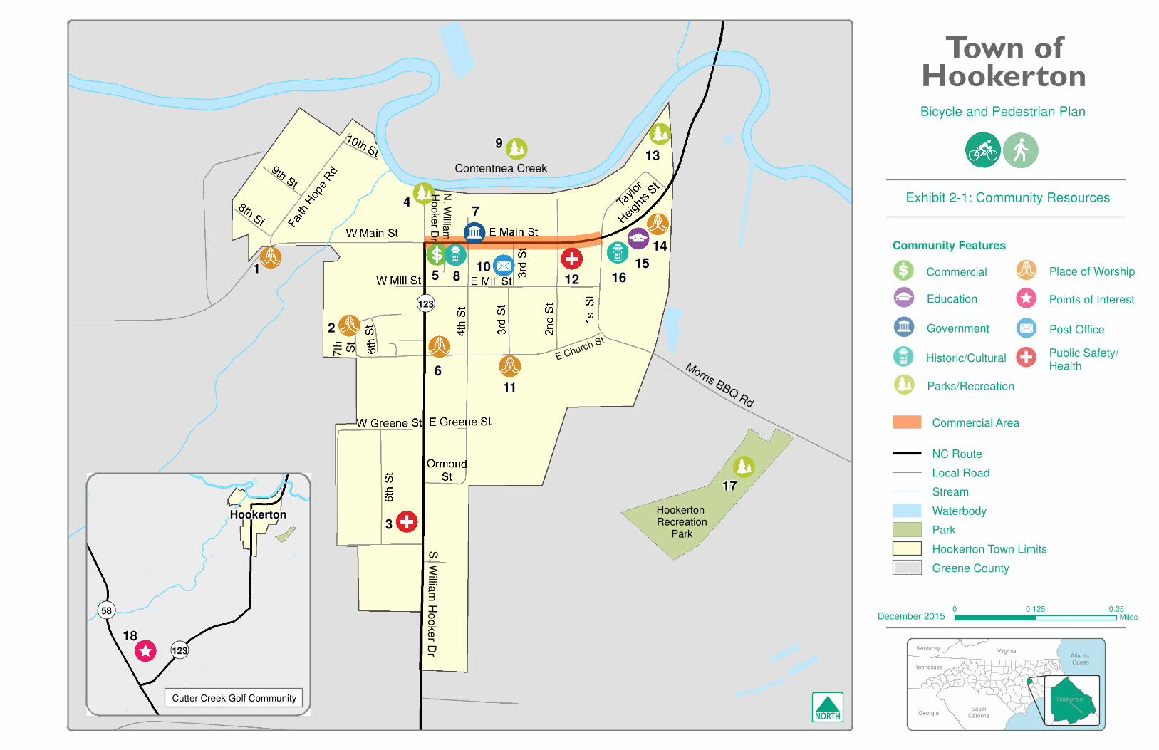
Community Features 2.2
Hookerton has several community features that provide important services and enrich the quality of life for residents. These features serve as potential pedestrian and bicyclist origins and destinations. The Steering Committee reported current pedestrian and bicyclist activity at some of these places. By improving connectivity between these locations and Hookerton’s neighborhoods, residents will be more likely to walk or ride a bike.
These features are listed in Table 2-1 and mapped on Exhibit 2-1. The map ID in the table below corresponds to the map. An infrastructure project’s ability to provide connectivity to these origins and destinations was one variable used to prioritize projects.
Table 2-1: Community Features
MAP ID NAME TYPE
1 Faith Hope Temple United Holy Church Place of Worship
2 Star of Zion Place of Worship
3 Hookerton Family Practice Public Safety/Health
4 Boat Launch (William Hooker Drive) Parks/Recreation
5 Family Dollar Commercial
6 Hookerton Christian Church Religious
7 Hookerton Town Hall and NC DMV Government
8 Historic Marker Historic/Cultural
9 Trails north of Contentnea Creek* Parks/Recreation
10 US Post Office Post Office
11 Hookerton United Methodist Church Religious
12 Hookerton Volunteer Fire Department Public Safety/Health
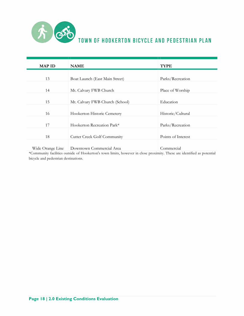
Page 18 | 2.0 Existing Conditions Evaluation
MAP ID NAME TYPE
13 Boat Launch (East Main Street) Parks/Recreation
14 Mt. Calvary FWB Church Place of Worship
15 Mt. Calvary FWB Church (School) Education
16 Hookerton Historic Cemetery Historic/Cultural
17 Hookerton Recreation Park* Parks/Recreation
18 Cutter Creek Golf Community Points of Interest
Wide Orange Line Downtown Commercial Area Commercial *Community facilities outside of Hookerton's town limits, however in close proximity. These are identified as potential bicycle and pedestrian destinations.
Contentnea Creek
E Church St
Morris BBQ Rd
S. W
illiam
Ho
oker D
r
N. W
illiam
H
oo
ke
r Dr
16
Hookerton Recreation
Park
15
17
7t h
S
t
74
5
6
13
108
112
11
2
9
3
14
¬«123
NC Route
Local Road
Stream
Waterbody
Park
Hookerton Town Limits
Greene County
Town ofHookertonBicycle and Pedestrian Plan
Exhibit 2-1: Community Resources
0 0.250.125Miles
Atlantic Ocean
SouthCarolina
Virginia
Georgia
Kentucky
Tennessee
December 2015
Hookerton
Commercial Area
Hookerton
18
Cutter Creek Golf Community
¬«123
¬«58
Parks/Recreation
Community Features
Public Safety/Health
Historic/Cultural
Place of Worship
Points of InterestEducation
Government
Commercial
Post Office
N

2.0 Existing Conditions Evaluation | Page 21
Infrastructure 2.3
Roads
The road network present in Hookerton is typical of a small town. Most roads are oriented north-south and west-east, forming a grid pattern. The only state-maintained roads in Hookerton are NC 123 (South William Hooker Drive and East Main Street), West Main Street, 1st Street, and Morris BBQ Road. All other public roads are maintained by the Town. NC 123 runs through Hookerton, connecting it to Kinston to the south and Farmville to the north. Locally, the north-south portion of the highway is called South William Hooker Drive while the east-west portion is East Main Street. There are no road projects currently planned for Hookerton that are included in the State Transportation Improvement Program (STIP).
Roads within Hookerton are primarily two lanes with approximately 10 to 12 foot wide travel lanes. NC 123 and West Main Street have curb and gutter roadway sections. Sidewalks are present on the north side of West Main Street and portions of East Main Street. A marked crosswalk is present at the intersection of East Main Street and 2nd Street. There is a crosswalk with curb ramps at the intersection of Main Street and William Hooker Drive. These crosswalks and sidewalks are shown on Exhibit 2-2. On-street parking spots exist along
East Main Street in the downtown area from William Hooker Drive to 3rd Street. East Main Street by the Mt. Calvary Free Will Baptist Church is two lanes with a center turn lane. Smaller, residential streets are narrower and do not have sidewalks or curb and gutter sections. They range from approximately 12 to 20 feet wide.
Speed limits vary between 25 and 55 mph. East Main Street has a 25 mph speed limit in the downtown area. East Main Street, east of 3rd Street, West Main Street, NC 123, and 1st Street have 35 mph speed limits. The speed limit increases to 45 mph on 1st Street and 55 mph on NC 123 and Dixon Farm Road outside of the town limits.
Main Street, Hookerton, NC AECOM, 2015
NC 123, Hookerton, NC AECOM, 2015

Page 22 | 2.0 Existing Conditions Evaluation
Right-of-ways were estimated using aerial photography and parcel data, and range from approximately 50 to 80 feet for two-lane roads and approximately 100 feet where East Main Street is three lanes. The road sections on NC 123 and West Main Street range from approximately 35 to 55 feet, indicating that there could potentially be 15 to 45 feet of available right-of-way for pedestrian and bicycle infrastructure. These estimates would need to be verified during the planning and engineering phases of future projects.
There are two bridges within Hookerton: West Main Street over Rainbow Run, a tributary to Contentnea Creek (NCDOT Bridge ID #390043), and East Main Street (NC 123) over Contentnea Creek (NCDOT Bridge ID #390023). The West Main Street bridge is relatively new, built in 2008. It features a sidewalk on the north side of the bridge and roadside offsets with curb and gutter along Main Street from N. William Hooker Drive to Faith Hope Road. The East Main Street bridge was built in 1992 and has paved shoulders only with no sidewalks.
Currently, NCDOT is resurfacing and widening South William Hooker Drive (NC 123). The road is being resurfaced from the town limits to Greene Street. South of the town limits to NC 58, the road is being widened from 22 feet to 26 feet. A one-foot paved shoulder is being added as well.
Characteristics of the road network in Hookerton including ownership, surface type, length, speed limits, traffic, right-of-way, resurfacing schedule, and barriers and limitations for bicycle and pedestrian infrastructure are summarized in Table 2-2.
Bridge on East Main Street over Contentnea Creek AECOM, 2015

2.0 Existing Conditions Evaluation | Page 23
Table 2-2: Hookerton Road Inventory
ROAD OWNERSHIP
LENGTH (miles in
Hookerton)
SPEED LIMIT (mph)
TRAFFIC (2013
AADT)
RIGHT OF WAY
(feet)
PAVEMENT WIDTH
(feet) CURB/
GUTTER RESURFACING
SCHEDULE EXISTING BIKE/PED
FACILITIES BARRIERS/ LIMITATIONS
1st St. State 0.15 35 - 50 30 Yes - None Above ground utilities on both sides of roadway
2nd St. Town 0.23 35 - 65 20 No - Crosswalk on east side of intersection
with E. Main St. Above ground utilities on east side of roadway,
narrow travel lanes
3rd St. Town 0.17 35 - 30 - 60 15 - 20 No - None Above ground utilities on both sides of roadway,
constrained right-of-way, narrow travel lanes
4th St. Town 0.41 35 - 50 - 60 15 - 20 No - None Above ground utilities on east side, narrow travel
lanes, vegetation within right of way
6th St. Town 0.24 35 - 20 - 60 20 No - None
Above ground utilities on both sides of roadway, narrow travel lanes, constrained right of way,
vegetation within right of way
7th St. Town 0.23 35 - 20 - 50 15 No - None Narrow travel lanes, constrained right of way
8th St. Town 0.07 35 - 20 10 No - None Above ground utilities on both sides of roadway,
narrow travel lanes, constrained right of way
9th St. Town 0.08 35 - 20 10 No - None Above ground utilities on both sides of roadway,
narrow travel lanes, constrained right of way
10th St. Town 0.06 35 - 15 15 No - None Gravel roadway
Dixon Farm Rd. State 0.03 35 - 60 24 No - None Ditches along both sides of the roadway
E. Main St. (NC 123) State 0.42 25 - 35 2,500 80 - 100 40 – 50 Yes -
Sidewalks from intersection with S. William Hooker Dr. to Mt. Calvary
FWB Church and school Existing on-street parking, above ground utilities on
both sides of roadway
Mill St. Town 0.31 35 - 45 16 No - None Above ground utilities on north side of the roadway,
narrow travel lanes
Church St. Town 0.39 35 - 50 18 No - None Above ground utilities on north side of the roadway,
narrow travel lanes

Page 24 | 2.0 Existing Conditions Evaluation
ROAD OWNERSHIP
LENGTH (miles in
Hookerton)
SPEED LIMIT (mph)
TRAFFIC (2013
AADT)
RIGHT OF WAY
(feet)
PAVEMENT WIDTH
(feet) CURB/
GUTTER RESURFACING
SCHEDULE EXISTING BIKE/PED
FACILITIES BARRIERS/ LIMITATIONS
Greene St. Town 0.20 35 - 45 15 No - None Above ground utilities on north side of the roadway,
narrow travel lanes
Faith Hope Rd. Town 0.22 35 - 50 20 No - None
Above ground utilities on the west side of the roadway, narrow travel lanes, ditches along both sides
of roadway
Jonestown St. Town 0.07 35 - 15 15 No - None Narrow travel lanes, constrained right of way
Morris BBQ Rd. State 0.09 35 - 60 30 Yes - None Above ground utilities on north side of roadway
N. William Hooker Dr. Town 0.08 35 - 60 20 No -
Curb ramps at intersection with W. Main St.
Above ground utilities and ditches along both sides of roadway
Ormond St. Town 0.06 35 - 40 18 No - None Above ground utilities on south side of roadway, narrow travel lanes, vegetation within right of way
S. William Hooker Dr.
(NC 123) State 0.66 35 2,000 60 20 - 40
Yes, north of Greene
St.
Current resurfacing project within town limits and widening
outside of town limits None
Above ground utilities on both sides of road, ditches along both sides of roadway south of Greene St.
Stephenson St. Town 0.13 35 - 50 20 No - None Narrow travel lanes, ditches along both sides of
roadway
Taylor Heights St. Town 0.17 35 - 50 16 No - None
Above ground utilities on north side of roadway, narrow travel lanes, vegetation within right of way
W. Main St. State 0.21 35 - 80 30
Yes, except for south
side west of bridge -
Sidewalks and paved shoulder on north side of roadway Slope on south side of the roadway, west of bridge

2.0 Existing Conditions Evaluation | Page 25
Public Transportation
Public transportation depends on a pedestrian and bicycle network in order for transit riders to safely access transit stops and destination points. A strong pedestrian and bicycle network links transit stops to community destinations, residences, and businesses. In Hookerton, the Greene County School System provides school bus transportation to students, a form of mass transit. Safety is compromised for students walking to bus stops where there is a lack of infrastructure present.
In addition to the school system, Greene County operates a demand/response transit service for the elderly and persons with disabilities. There is currently no scheduled fixed route transit service located within or near Hookerton. A pedestrian and bicycle network would support any future expansion to the public transportation network.
Utilities
Utilities are an important consideration for bicycle and pedestrian planning. Moving or replacing existing utilities to make room for new pedestrian and bicycle infrastructure can be costly and in some cases, prohibitive to install facilities. Often, sidewalks and multi-use paths are located on the side of the road where utilities are not present. The exact location of utilities will need to be surveyed during the engineering phase of each project. Coordination will need to occur with utility providers in the planning stage, before construction. General information about utilities in Hookerton is noted in Table 2-3.
Table 2-3: Utilities
UTILITY PROVIDER LOCATION
Electricity Town of Hookerton Above ground
Telephone Century Link Above ground
Cable/Internet Century Link/Infinity Below ground
Natural Gas Service not available Service not available
Water Town of Hookerton Below ground
Sewer Town of Hookerton Below ground
Bus in Hookerton, NC AECOM, 2015

Page 26 | 2.0 Existing Conditions Evaluation
Land Use and Development 2.4
Understanding the larger context of regional growth, demographics of an area, or social resources are necessary factors to the success of strategic land use development for a given town or region. The growth and development patterns expected for the Town of Hookerton should incorporate deliberate planning efforts for a variety of needs, including bicycle and pedestrian infrastructure.
Much of the Town is comprised of residential housing with some commercial businesses along Main Street. There is a high volume of vacant lots and aging structures. There is little to no industrial functions in the Town and some open space along Contentnea Creek, which serves as important historic and recreation functions. Outside the Town limits, Pitt County Memorial Hospital in Greenville and Spirit AeroSystems (one of the largest aerospace manufacturers in the state) impact the broader regional land use and development.
Development activity in Hookerton is minimal, but desired by residents to infill vacant or underutilized parcels. Without a comprehensive plan, Hookerton depends on the county land use and development planning efforts. For example, Greene County’s Comprehensive Transportation Plan indicates an expectation for residential growth to expand north and west of Hookerton, particularly along NC 58 to the south. Of note is the Cutter Creek Golf Club, which is located just south of Hookerton where NC 123 and NC 58 intersect. At build-out, this golf community is projected to contain approximately 650 homes.
Land Use in Greene County, NC
Greene County CTP, 2012

2.0 Existing Conditions Evaluation | Page 27
Pedestrian, Bicycle, and Vehicular Traffic Counts and Crash Data 2.5
Pedestrian and Bicycle Activity
Due in part to a lack of facilities by which to collect data, pedestrian and bicycle counts are not available for this Plan. However, the Steering Committee noted pedestrian and bicycle activity occurs on residential streets and Main Street. It was also noted that people often drive from outside of Hookerton and park at the medical center located off of South William Hooker Drive and walk within the residential areas for exercise.
NCDOT prepares Annual Average Daily Traffic (AADT) counts for state roads, which represent the vehicular traffic average for the year at specific points. Counts are collected every two years and are not available for every road. These counts, in conjunction with field visits and discussions with residents help identify high traffic areas that may pose safety concerns or barriers for pedestrians and bicyclists.
Two roads within Hookerton, East Main Street and South William Hooker Drive, have traffic counts available. The counts are listed in Table 2-4 for the most recent year available, 2013.
Table 2-4: Annual Average Daily Traffic (AADT) Counts
STREET LOCATION AADT (2013)
East Main Street East of the 4th Street intersection 2,500
South William Hooker Drive North of the Village Park Drive intersection 2,000 Source: NCDOT Traffic Survey Group, 2013.
Crash Data
The NCDOT Department of Bicycle and Pedestrian Transportation in collaboration with the UNC Highway Safety Research Center developed the Crash Data Tool, which is a compilation of reported pedestrian and bicycle crashes between 1997 and 2012. There are over 40,000 crashes recorded in the database with comprehensive information such as age, speed, and vehicle type to name a few.
There are no reported bicycle or pedestrian crashes in the database for Hookerton. It is possible that crashes went unreported to the NC Division of Motor Vehicles, which is the source for the database. Safety is still a concern for Hookerton. The Steering Committee noted safety concerns including inadequate lighting, physical deterioration in the condition of sidewalks, high vehicle speeds, and the overall lack of pedestrian and bicycle facilities within the town.

Page 28 | 2.0 Existing Conditions Evaluation
Existing Facilities and Activity Trends 2.6
There is generally a lack of bicycle and pedestrian facilities currently in the Town of Hookerton and there are gaps in the network that make bicycle and pedestrian travel difficult and often unsafe. There are also areas that do not meet standards required by the Americans with Disabilities Act (ADA). Exhibit 2-2 shows existing bicycle and pedestrian facilities in the Town.
Bicycle Facilities - Existing • Paved area between the travel lane and curb and gutter is provided along Main Street from Faith
Hope Road to 3rd Street • There is a shared use path in close proximity, north of Contentnea Creek
Bicycle Activity Trends • The Town of Hookerton currently does not have existing designated bicycle lanes on its roadways • Cyclists often travel on the roadway or in some areas, along a protected paved area • Residents cycle on the sidewalk along Main Street, making it unsafe for pedestrians
Sidewalk Facilities - Existing • The only existing sidewalks in Hookerton are along Main Street
Existing Pedestrian Intersection Improvements • At the intersection of Main Street and S. William Hooker Drive there are ramps at the northwest and
southeast corners • A crosswalk is painted and signed on East Main Street at the intersection with 2nd Street. • There are some residential areas that have four-way stop signs and offer some protection
Sidewalk Connectivity • There are no sidewalks that connect downtown and neighborhoods and other destinations within the
community including downtown services, churches, the local school, the community park, and recreation areas along Contentnea Creek
• The dominant roadways in the community with inadequate or missing sidewalks include, but are not limited to, 1st Street, 2nd Street, 4th Street, S. William Hooker Drive, and Church Road. Some residential streets not equipped with sidewalks still have relative safety due to minimal traffic.
• Gaps in existing sidewalks, portions of sidewalks with uneven surfaces, instances of varying curb heights and broken pavement are evident within the Town.
• A Safe Routes to School program initiative helped improve sidewalk facilities between Mt. Calvary Free Will Baptist Church and the Hookerton Town Hall on Main Street and 3rd Street. Construction of this project was completed in 2012.
Pedestrian Intersection Improvements • There is a need for additional crossing treatments in Hookerton such as painted street crossings or
other crossing signage with high-visibility • Unmarked crossings are currently not safe for pedestrians

2.0 Existing Conditions Evaluation | Page 29
Pedestrian Activity Trends • Residents can be seen walking throughout the downtown area and within neighborhoods, and to
areas along Contentnea Creek • There is currently no pedestrian facilities that connect the downtown area and adjacent residential
areas • Residents walk on the street, road shoulder, within the grassed area of right-of-way or on adjacent
private property • Hookerton is a destination for walkers who live in the rural areas of Greene County and drive into
Hookerton to walk on the residential streets that are safer for walking than rural highways.

� � � � � � �� � � �
� � � � �� �� � � � � � � � � � � � � � � � !
" # $ % & ' ( )*+,--,./01123454
6 7 7 8 9 : ; 7 <= 9 > : 9 ? ; @ 7 <A ? : 8
B C @ D ; @ < E : 7 ? F D @ F 9 7 G G D 9 ; DH @ ; I > J : K ? < F E J ; ; 9 : ? L 7 < EM ? @ < N ; : 9 9 ; G : 7 OP Q R @ L L @ ? O 6 7 7 8 9 : S : @ T 9; 7 U ? @ ; I 6 7 V 9 = 7 ? F Q W X YZ [ \ ] ^ ( _` ] a $ b \ ] $ c' ( d _ $ e" $ ( _ d f ] c gh $ d ij ] k & ` % e % ( lm d _ _ & _ [ ] ^ & ( g
Town ofHookerton
h _ c _ l ( d % $ & n g f d % c o _ $ a ] &# $ d i _ c [ d ] l l k $ b i' % c _ k $ b i' p $ d _ c q l _ h $ ( p
r r s t ur s v t u w x y z {| } ~ � � } � �� � � � �� � � } �� � � � ~ � � �� � � � � � � �
� � � � � � �� � � } � � � �� � � � � � � � �� � � � � � � � � � � �
� � � � � � } � �

2.0 Existing Conditions Evaluation | Page 31
Opportunities and Constraints 2.7
Opportunities are those conditions that provide favorable bicycle and pedestrian alternatives. Constraints are conditions that limit bicycle and pedestrian access. Constraints can be analyzed and potentially become opportunities depending on actions taken to address the restriction. Through an analysis of Hookerton’s existing bicycle and pedestrian facilities, a series of opportunities and constraints have been identified to help develop and structure implementation strategies.
Hookerton’s historic roots as a community along the Contentnea Creek create robust opportunities for implementation of walking and bicycling facilities. Providing bicycle and pedestrian infrastructure will allow users to explore the natural systems associated with the waterway and connect with the cultural heritage of the area that goes back to Colonial times before the Revolutionary War. The recently installed trail system north of Contentnea Creek, the boat ramps, and dock provide opportunities, while outside of Hookerton’s limits, still allow for the citizens of Hookerton to enjoy the natural beauty of the area. In addition, an improved bicycle and pedestrian network both within Hookerton and within the region will provide dynamic interactions between citizens and their community while also providing improved health benefits and diverse mobility options. These natural and cultural treasures will help bring users from outside Hookerton and may provide secondary benefits such as economic
investment from visitors. This regional draw could spur new recreational opportunities and further increase desire for improved bicycle and pedestrian facilities such as playgrounds, historical visitation sites and/or encourage local business development.
The community has seen its population decrease over the past decade partially due to an aging population and a lack of jobs in the immediate vicinity. The development of the Cutter Creek Golf Community to the south of Hookerton will provide additional population to utilize bicycle and pedestrian facilities in Hookerton and provide beneficial financial opportunities for the Hookerton economy.
Contentnea Creek, Hookerton, NC AECOM, 2015
Sidewalk Condition in Hookerton, NC AECOM, 2015

Page 32 | 2.0 Existing Conditions Evaluation
Opportunities • Capitalize on existing natural resources as a way to draw local and regional visitors • Better access and mobility through local and regional bicycle routes and improved sidewalks • Improved health benefits as a result of safer and better connected bicycle and pedestrian facilities • Develop neighborhood streets that currently appear quiet with minimal traffic to further create safe
bicycle and pedestrian environments without the presence of specific bicycle or pedestrian facilities • Secondary impacts such as economic growth or investments as a result of visitor population using
bicycle and pedestrian facilities, such as nature trails • Expand existing streetscapes and add bicycle lanes or shared lane markings on roadways with existing
roadways that are wide enough, such as: o Main Street through town from near the entrance to the East Main Street Boat Launch to
Dixon Farm Road o S. William Hooker Drive from Main Street to town limits o S. 1st Street (Morris BBQ Road) from Main Street to about 400 feet west of the entrance to
the Hookerton Recreation Park • Coordinate with bicycle organizations/clubs to help develop local activities and events, such as a
bicycle rodeo or providing bicycle helmets to children
Constraints • Gaps in sidewalks including areas that are not ADA accessible • Inadequate pedestrian infrastructure at intersections along high priority roadways • Right-of-way limitations, roadside ditches, and utilities may hinder the installation of sidewalks • Lack of existing Town policies that require sidewalk and bicycle infrastructure • Short term impacts related to construction of bicycle or pedestrian facilities. This may include the
need for detour routes, noise, or visual effects.
Existing Plans and Programmed Projects 2.8
Greene County and the Eastern Carolina Rural Planning Organization (ECRPO) have each produced and adopted comprehensive transit and transportation plans that include recommendations within Hookerton’s town limits. The following plans have been reviewed in order to foster connectivity and consistency within the region:
• Downtown Hookerton Plan (2008) • Hookerton Recreational Master Plan (2011) • Master Plan for Landscape Enhancement (2008) • Greene County Coordinated Public Transportation and Human Services Transportation Plan (2009) • Greene County Comprehensive Transportation Plan (CTP) (2012)

2.0 Existing Conditions Evaluation | Page 33
Downtown Hookerton Plan
A plan for downtown Hookerton was created in preparation for a large golf course and residential community to the south of the town. The plan focuses on defining a vision, rejuvenating the central business district, connecting the area with Contentnea Creek, providing improved bicycle and pedestrian infrastructure, and beautifying the downtown core. Recommendations for bicycle and pedestrian facilities made in the plan include:
• Widening and improving sidewalks along Main Street in downtown Hookerton • A bridge over Contentnea Creek that would serve pedestrians and bicyclists near 4th Street • A designated bicycle trail along NC 123, north of Hookerton to the Pitt County Line and connection
to State Bicycle Route 2 • A designated bicycle trail from the Cutter Creek community south of Hookerton along William
Hooker Drive to Main Street • A designated bicycle trail that loops around downtown Hookerton along Morris BBQ Road,
Contentnea Creek, William Hooker Drive, and E. Church Street • A designated trail and/or greenway along the south bank of Contentnea Creek that would tie into a
proposed park and picnic area
Conceptual Streetscape Improvements along Main and 5th Street, Hookerton NC Downtown Hookerton Plan, 2008

Page 34 | 2.0 Existing Conditions Evaluation
Master Plan for Landscape Enhancements
The Master Plan for Landscape Enhancements for the Town of Hookerton was created in 2008. The plan focuses on landscape improvements along Main Street, William Hooker Drive, and 1st Street. Recommendations made in the plan include the planting of crape myrtle trees, recommended spacing of the trees, planting boxes (where needed), the extension of curb and gutter where it is lacking along the streets, and recommendations for shrubbery and trees as you enter the community. Plantings have been completed along West Main Street from Faith Hope Road to William Hooker Drive when the bridge was replaced in 2013.
Hookerton Master Plan for Landscape Enhancements NCDOT, 2008

2.0 Existing Conditions Evaluation | Page 35
Hookerton Recreational Master Plan
The Hookerton Recreational Master Plan was created in 2011. The plan focuses on expanding recreational opportunities along Contentnea Creek for residents and as a way to increase tourism in the town. Recommendations made in the plan include:
• RV campground • Kayak/canoe launch • Playground • Boat ramp (completed in 2013) • Pedestrian bridge • Recreational trails (completed in 2015) • Beach area • Outdoor education center
Other items discussed in the plan include adding outdoor grills, picnic tables, and restrooms for campers or those boating along Contentnea Creek.
Greene County Coordinated Public Transportation and Human Services Transportation Plan
The Coordinated Public Transportation and Human Services Transportation Plan (CPT-HSTP) was developed to incorporate private and non-profit transportation and human services providers and the general public. The ECRPO and Greene County Transportation (GCT) worked to detail the transportation needs of the County. Aspects studied include an inventory of transportation and human services facilities, users of the transit system, needs assessment including the identification of system gaps, prioritization of needs, and how the findings are included in the LRTP for the County.
Greene County Comprehensive Transportation Plan
The Greene County CTP presents recommendations for each mode of transportation in the County. The CTP was a joint planning effort between the county and the towns of Hookerton, Snow Hill, and Walstonburg and covers transportation planning needs through 2035. The CTP assists elected officials and other transportation decision makers in the analysis and recommendations for highway, public transit, bicycle, and pedestrian improvements. The major facility improvement recommendations in the Plan include widening NC 58, constructing a four-lane expressway facility on a new location (US 258 Bypass), and improvements to US 13/258. Specific to Hookerton, recommendations include improvements to bicycle and pedestrian facilities along NC 123 and Main Street, the two primary thoroughfares through the town. The Greene County CTP was adopted by the Board of Commissioners and the participating towns in the spring of 2012 and the NC Board of Transportation in July of 2012. There are no programmed projects from the CTP within or immediately adjacent to Hookerton.
Hookerton Boating Access and Recreation Area AECOM, 2015

Page 36 | 2.0 Existing Conditions Evaluation
Bicycle (left) and Pedestrian (right) Facilities needing Improvements
Greene County Comprehensive Transportation Plan, 2012

public input anddata collection

3.0 Public Input and Data Collection | Page 37
3.0 Public Input and Data Collection
Steering Committee 3.1
The Steering Committee for bicycle and pedestrian efforts was formed to assist in the development of this Plan and includes a dedicated group of local officials, staff, stakeholders, and citizens to incorporate a diverse range of community perspectives. The Steering Committee met throughout the planning process to help shape the Plan by identifying; goals and objectives, pedestrian constraints and opportunities and prioritizing recommended projects. Committee members are listed in Table 3-1.
An initial meeting was conducted between the project team and the Steering Committee Lead. This meeting set the stage for future Steering Committee meetings and the overall project process.
At the first Steering Committee meeting on January 29, 2015, the group streamlined a vision statement for the Plan and discussed issues the community is facing with regards to bicycle and pedestrian infrastructure. Members discussed an interest in a plan with small to large-scale projects that can be implemented through phased planning methods.
The Committee met twice throughout the duration of the project:
• January 29, 2015 – First Steering Committee Meeting • April 30, 2015 – Public Open House and Second Steering Committee Meeting
The meeting agendas and minutes are included in Appendix A – Public Involvement.
Table 3-1: Steering Committee
Name Affiliation
April Baker Town Clerk
Lemmie Smith Sheriff
Doris Jones Commissioner
Bille Albriton Community Member
Lou Ann Shackelford Community Member
Timothy Chare Community Member
Megan Ham Community Member
Sandra Stocks Community Member

Page 38 | 3.0 Public Input and Data Collection
Public Open House 3.2
The Public Open House was held on April 30, 2015 immediately following the second Steering Committee Meeting. A brief presentation about the planning process and highlights of the plan was presented. In addition, maps showing the recommended projects and copies of the draft plan were available for the attendees to view. The attendees were also invited to provide feedback by completing a comment form.
A copy of all meeting materials is provided in Appendix A – Public Involvement.

recommendations

4.0 Recommendations | Page 39
4.0 Recommendations
This chapter identifies infrastructure and program recommendations that correspond to the goals and objectives of this Plan. Included in this chapter are facility descriptions, proposed bicycle and pedestrian facilities and recommended policies and programs. All bicycle and pedestrian facility recommendations along NCDOT-maintained roadways will require review and approval by NCDOT Highway Division 2 prior to implementation
Facility Types 4.1
This section provides a general overview of bicycle, pedestrian, and shared use facilities. It explains the differences between spot and linear improvements. Bicycle and pedestrian facilities on bridge projects will match standard widths used for the adjacent facility (such as a bicycle lane, sidewalk, and shared use path) and be in compliance with NCDOT bridge safety standards. Design guidelines are included in Appendix C: Design Guidelines.
Bicycle Facilities A successful bicycle network consists of on-road bicycle facilities, bike parking, intersection design, and bicycle specific signals and signage. Bicycle racks encourage cycling by providing ways to store bikes safely, and discourage users from locking bikes to railings, street trees, and other site furnishings.
Dedicated bicycle lanes are the preferred option for an on-street facility, allowing for higher volumes of bicyclists to operate at increased speeds. A bicycle lane (4 to 6 feet in width) can, with uninterrupted flow, carry a high volume of bicycles per hour in one direction. A conventional bike lane is located adjacent to motor vehicle travel lanes and in the same direction as motor vehicle traffic. According to the Federal Highway Administration (FHWA), there are five different types of linear bicycle facilities2:
Shared Lane: A “standard width” travel lane that both bicycles and motor vehicles share. Shared lane markings increase a motorist’s awareness of the presence of cyclists, reduce the incidence of wrong-way bicycling, and indicate to both drivers and cyclists the ideal lateral positioning of the cyclist
Wide Outside Lane: An outside travel lane with a width of at least 14 feet to accommodate bicyclists.
2 Federal Highway Administration University Course on Bicycle and Pedestrian Transportation http://www.fhwa.dot.gov/publications/research/safety/pedbike/05085/chapt13.cfm
Bicycle Sharrow Flickr Creative Commons, 2012

Page 40 | 4.0 Recommendations
Bicycle Lane: A portion of the roadway designated by striping, signing, and/or pavement markings for preferential or exclusive use by bicycles and/or other non-motorized vehicles.
Wide Shoulder: A paved portion of the roadway to the right of the travel way designed to serve bicyclists, pedestrians, and others. Along rural roads, sidewalks are typically not feasible due to lack of development or destinations, cost, environmental impacts, or other considerations.
Multiuse Path: A facility that is physically separated from the roadway and intended for use by bicyclists, pedestrians, and others. The Mountains to Sea Trail is an example of an extensive bike trail that provides opportunities for serious cyclists, casual riders, and a variety of other uses. In some areas, the trail has extensive dedication to bicycle facilities including separated facilities from the roadway, lane markings, and signage.
Sidepath: Sidepaths are multi-use paths located exclusively adjacent to a roadway, typically within the road ROW. This provides a buffer from vehicular traffic for bicycle and pedestrian travel.
Pedestrian Facilities
Walkability in urban, suburban, and rural communities offers many benefits including improved health benefits, reduced environmental impacts and financial commitments from decreased dependency on the automobile. Providing infrastructure and making existing facilities safer and more inviting for pedestrians can help to increase the walkability of a community. The
following details linear pedestrian facilities only.
Sidewalks are the primary elements of the pedestrian environment and are generally constructed of concrete, pavers, or other hard surface. In urban areas, sidewalks are sometimes located adjacent to the road with a curb and/or grassy strip separating users from vehicular traffic. In suburban areas, sidewalks or wide shoulders along the roadway may be used for pedestrian use. In rural areas, wide shoulders may be the only area for pedestrian use and in many cases there are no specific improvements to accommodate pedestrian users.
Pedestrian bridges are typically used to help extend walks and trails across rivers, roads, or other physical elements that create barriers for circulation. Pedestrian bridges can be utilitarian or an iconic feature of a community.
Walkability measures how walkable an area is for pedestrian use.
Pedestrian Bridge AECOM, 2015

4.0 Recommendations | Page 41
Shared Use Facilities
NCDOT adopted a “Complete Streets” policy (CS) in 2009, which directs NCDOT to consider and incorporate all modes of transportation when building new projects or making improvements to existing infrastructure. Complete Streets are designed to be safe and comfortable for all users, including pedestrians, bicyclists, transit riders, motorists, and individuals of all ages and capabilities.3 Part of designing with CS principles includes the impact of streets patterns on trip length, connectivity between resources, intersection use, and the overall experience of the user. Both cyclists and pedestrians can benefit from a street that has
been designed with the CS policy. Benefits include improvement in access for children and individuals with accessibility needs, health advantages, improved public transportation services, economic revitalization, safety enhancements, roadway equity, and a more livable community.4
Multiuse paths are physically separated from vehicular traffic and may include bicycle paths, rail-trails, side paths, or dedicated paths separate from a roadway specific to bicycle and pedestrian use. Multiuse paths are a protected facility option because they are not shared with motor vehicles. They serve multiple purposes including recreation and transportation.
Spot Improvements and Linear Facilities
Spot Improvements address bicycle and/or pedestrian problems at specific locations such as intersections, short lengths of a roadway, or single destinations. These types of improvements are often low cost and enhance bicycle and/or pedestrian through surface improvements (pothole patching), signing and striping (pedestrian signs or bicycle lane striping), access improvements (traffic signaling), and bike rack installation.5 Other spot improvements include crosswalk markings, pedestrian signal heads, pedestrian refuges, or curb extensions.
Linear Improvements are similar to spot improvements but are specific to linear project needs such as sidewalks, bike lanes, or improvements to streetscapes.
3 NCDOT Complete Street Planning and Design Guidelines at http://completestreetsnc.org/ 4 National Complete Streets Coalition, http://www.smartgrowthamerica.org/complete-streets/complete-streets-fundamentals/factsheets 5 NCDOT Spot Improvement Program , https://connect.ncdot.gov/municipalities/PlanningGrant/Sample%20Plans/Hertford%20Sample%20Plan%20-%20Section%209.pdf
Bike Lane Signage Road Traffic Signs, 2015
Multiuse Path Flickr Creative Commons, Mike Juvrud, 2010

Page 42 | 4.0 Recommendations
Recommended Facilities 4.2
Through collaboration with the Steering Committee and input
from the public workshop, infrastructure projects were identified
to improve bicycle and pedestrian safety, increase connectivity,
and address the goals and objectives of this Plan. These projects
are divided into linear facilities and spot improvements.
Together, they form the physical infrastructure recommendations
for the Town’s bicycle and pedestrian network. Linear and
spot/intersection projects are often constructed concurrently.
The linear facility projects consist of several types: sidewalks,
bicycle lanes, and shared use paths. These facility types are
detailed in Section 4.1:Facility Types.
Spot improvements occur at specific points rather than along sections of roadway. Examples of spot
improvements include signage, crosswalks, pedestrian signals, bicycle racks, and trail access points. Often
times, linear and spot improvements are implemented concurrently.
In addition to infrastructure projects, policies, ordinances, and programs have also been proposed to work in
tandem with linear facilities and spot improvements. These policies, ordinances, and programs are outlined in
Section 4.4 - Policies.
Linear Facilities
Linear Facilities are classified further by their activity type:
pedestrian, bicycle, and shared use. Together, linear facilities
form a comprehensive bicycle and pedestrian network to
provide safe transportation choices for the community. A
total of fifteen linear facility projects are recommended, and
are discussed below and described in Table 4-2 and shown
on Exhibit 4-1, Exhibit 4-2, Exhibit 4-3, and Exhibit 4-4.
The map ID in the table corresponds to these exhibits.
Recommended wide paved shoulders and bicycle lanes are
proposed for both sides of the road. Wide paved shoulders
and bicycle lanes must be constructed along both sides of
the roadway to adequately address safety according to
NCDOT typical sections (see Appendix C: Design
Guidelines). Except for high traffic areas, sidewalks are
proposed for one side of the road.
Hookerton, NC
AECOM, 2015
High Visibility Crosswalk
Flickr Creative Commons, David, 2010

4.0 Recommendations | Page 43
Main Street
Main Street serves as a gateway to the community and encompasses downtown Hookerton and many of the key points of interest in this community. Improving bicycle and pedestrian facilities between these points of interest aligns with the Goals established by the Steering Committee. The sidewalk system is mostly complete, with the exception of a few gaps between William Hooker Drive and 3rd Street. Given that this segment of Main Street contains several businesses and Town Hall, it is recommended that sidewalk improvements be made on both sides of the street and be 10 feet wide to match existing sidewalk segments and to match the recommendations in the Downtown Hookerton Plan. This project could be implemented into phases, with improvements made to one side of the street at a time. Constraints include various levels of topography that will need to be addressed to make sure that the improved facility is handicap accessible.
Adding bicycle lanes along one of the community’s most heavily traveled roads would improve the safety of bicyclists. The existing roadway is wide enough to safely accommodate bike lanes from William Hooker Drive through 1st Street. From 1st Street through the Town Limits, shared lane markings are recommended. Constraints include above ground utilities, parallel parking, driveways, and turn lanes.
William Hooker Drive
Similar to Main Street, William Hooker Drive also serves as a gateway to the community and also connects several of the key points of interest, as well as several residential areas. Improving bicycle and pedestrian facilities between these community connections aligns with the Goals established by the Steering Committee. There are currently no sidewalks or bicycle facilities located along this roadway.
Sidewalk facilities are recommended to run from the boat launch located north of Main Street through the town limits. The proposed facility is recommended to be on the east side of the road. Bicycle lanes are recommended from Main Street through the town limits. The existing roadway is wide enough to accommodate bicycle lanes from Main Street through Greene Street. Shared lanes are recommended from Greene Street south to the town limits. Constraints include above ground utilities on both sides of the road.
1st Street/Morris BBQ Road
1st Street connects Main Street to the Hookerton Community Park and several residential areas. There are currently no bicycle or pedestrian facilities located along this roadway. Providing pedestrian and bicycle accommodations along this roadway would improve mobility through the creation of safe networks.
Sidewalk facilities are recommended on the west side of the street from Main Street through Church Street. Bicycle lanes are recommended from Main Street to 1st Street, and shared lane markings from 1st Street through the town limits and the entrance to the Hookerton Community Park. Shared lanes or wide paved shoulders could also be considered if the existing roadway width is not wide enough in all locations. Constraints include above ground utilities on both sides of the road and the narrowing of 1st Street immediately before the entrance to the Hookerton Community Park.

Page 44 | 4.0 Recommendations
Church Street
The section of Church Street that runs from William Hooker Drive to 1st Street provides an east-west connection in the community and connects the community facilities located along William Hooker Drive with those located along 1st Street. Providing pedestrian facilities along this roadway would align with the Goals established by the Steering Committee by improving the safety of pedestrians.
In the short-term, wide paved shoulders are recommended. In the long-term, sidewalks are recommended along the south side of this roadway. Existing right-of-way is wide enough to accommodate wide paved shoulders and sidewalks. Constraints include ditches along both sides of the road and above ground utilities.
Faith Hope Road
Faith Hope Road is a quiet residential street in the northwest part of the town. It provides connectivity between a residential area and to West Main Street. Pedestrian accommodations are proposed on this road to improve pedestrian safety, and as a future connection to the proposed Rainbow Run Path.
In the short-term, wide paved shoulders are recommended. In the long-term, sidewalks are recommended along the east side of this roadway. Existing right-of-way is wide enough to accommodate wide paved shoulders and sidewalks. Constraints include ditches along both sides of the road and above ground utilities.
Hookerton Park Connector
The Hookerton Park Connector would be a shared use path that would be built on new location and provide a connection in the southside of Hookerton from William Hooker Drive over to the back side of the Hookerton Recreation Park. This would improve pedestrian and bicycle connections between a residential area and the community park.
This project is proposed as a paved shared use path that would be constructed on new location. Implementation constraints include the purchase of land for right-of-way from several property owners would be required.
Historic Cemetery Trail
The Historic Cemeteries Trail would be a shared use path that would provide pedestrian connections between cultural and historic sites that includes the historic cemetery and the natural area along Contentnea Creek and the Boat Launch located along East Main Street.
The project is proposed as an unpaved shared use path that would be constructed on new location starting at the historic cemetery located on East Main Street and looping along Contentnea Creek and connecting back to East Main Street near the boat launch. Implementation constraints include the purchase of right of way from multiple property owners.

4.0 Recommendations | Page 45
Rainbow Run Path
The Rainbow Run Path would be a shared use path that would provide pedestrian connections between the residential area located off of Faith Hope Road, the natural area located along Rainbow Run and Contentnea Creek, and the commercial businesses located along Main Street.
The project is proposed as an unpaved shared use path that would be constructed on new location starting near 10th Street, traversing near Rainbow Run, connecting to the boat launch located off of William Hooker Drive, and finally tying into the proposed pedestrian bridge over Contentnea Creek near 4th Street. Implementation constraints include the purchase of right of way from multiple property owners.
Spot Improvements Spot improvement projects are proposed at intersections and crossings to improve safety for pedestrians and bicyclists.
Several crosswalks are proposed along Main Street and William Hooker Drive. These crosswalks, in combination with appropriate signage are intended to improve safety for pedestrians by providing increased visibility. They would be installed once adjoining sidewalks are constructed. The proposed crosswalks are listed below:
• 1st Street at East Main Street: south leg of intersection • 3rd Street at East Main Street: east and south legs of intersection • 4th Street at Main Street: all four legs of intersection • Church Street at William Hooker Drive: east and north legs of intersection • Greene Street at William Hooker Drive: east leg of intersection • Main Street at William Hooker Drive: east and north legs of intersection • Mill Street at William Hooker Drive: east leg of intersection • Ormond Street at William Hooker Drive: east leg of intersection • Stephenson Street at William Hooker Drive: north leg of intersection
The crosswalk is proposed at Stephenson Street and William Hooker Drive is intended to serve pedestrians walking to Hookerton Family Practice and the informal walking group noted by the Steering Committee. This group frequently walks on Stephenson Street, William Hooker Drive, and Greene Street.
Access points are proposed at the entrances to shared use paths. Bollards will be installed at these access points to prevent unauthorized access to motor vehicles. Bollards are designed to be lowered or removed in case of an emergency for police, fire, and rescue access. Wayfinding signs and maps would be included at access points as well to orient visitors and promote Hookerton’s downtown and natural areas.

Page 46 | 4.0 Recommendations
Additional street lighting is proposed along Stephenson Street, West Greene Street, South 6th Street, and South 7th Street. The additional street lights are mean to supplement the existing street lights to make this area a safer option for walking after dark.
Bike lane signs are recommended on Main Street, Morris BBQ Road, and William Hooker Drive to improve way finding and safety for cyclists. These signs would be installed where bicycle lanes are proposed by this Plan.
Pedestrian, bicycle and shared use spot improvements are listed in Table 4-3 and are graphically shown on Exhibit 4-1, Exhibit 4-2, Exhibit 4-3, and Exhibit 4-4. The map ID in the table corresponds to the exhibit.

4.0 Recommendations | Page 47
Prioritization Projects were prioritized in order to most efficiently and effectively improve bicycle and pedestrian safety and connectivity in Hookerton and to respond to public input. In a context where funding is limited, prioritization is essential for achieving the maximum benefits under constrained budgets. Providing a method and framework by which to prioritize projects assists in making decisions in a data driven format and reduces subjectivity.
Projects were prioritized by applying several qualitative criteria that relate to the Plan’s vision, goals, and objectives while at the same time accounts for the community’s interests. These criteria were agreed upon by the Steering Committee. The criteria applied to linear facilities for bicycle, pedestrian, and shared use paths were:
• Connectivity • Implementation • Safety • Community Interest
Each criterion received a score between 1 and 3. The scores in the community interest category were calculated by averaging the points received from the Steering Committee members, who were invited to score each linear project at the second Steering Committee meeting. Scores for this category and the others are explained in Table 4-1
Projects were then organized into three priority groups: low, medium, and high. When possible, the projects were spread evenly between these categorizations of low, medium, and high.
Spot improvements were not prioritized because they vary between types (e.g. crosswalk vs bike rack) and thus a comparison between the types would not offer a fair prioritization. In addition, it is also assumed that some would be built concurrently with the linear facility.
Prioritization results are meant to serve as a general guide. There may likely be opportunities to implement these projects in an order different than the order in which they were prioritized. For example if NCDOT is repaving William Hooker Drive, then it would be advantageous to construct bicycle lanes at that time even though it may have ranked lower than other projects. The prioritization in this Plan should generally be followed as it directly reflects the public input from Town residents and the Steering Committee. This should not, however, prevent the Town from taking advantage of pedestrian or bicycle improvements as opportunities present themselves.

Page 48 | 4.0 Recommendations
Table 4-1: Prioritization Criteria
CRITERIA 1 POINT 2 POINTS 3 POINTS
Connectivity
• Limited connectivity improvements to a single community feature
• Does not connect or tie into any other bicycle and/or pedestrian facilities
• Improves connectivity between more than one community feature
• Connects/ties into another bicycle and/or pedestrian facility
• Increases connectivity to multiple community features
• Connects/ties into two or more bicycle and/or pedestrian facilities
Implementation • Privately owned land • Right-of-way constraints • Outside of town limits
• Privately owned land where the property owner is willing to grant an easement, sell or donate right-of-way.
• Right-of-way constraints • Publicly owned land • Available right-of-way
Safety
• No reported pedestrian, bicycle, or vehicular crashes
• Residential street, low traffic volumes
• No reported pedestrian, bicycle, or vehicular crashes
• Major road, heavier traffic volumes
• Reported pedestrian, bicycle, or vehicular crashes
• Major road, heavier traffic
Community Interest • Low Interest • Medium Interest • High Interest
Linear Facilities
Bicycle and pedestrian facilities are prioritized together because they typically share common road segments. It is advantageous to implement bicycle and pedestrian projects on the same road segment simultaneously in order to realize cost savings and minimize disruptions due to construction.
The highest possible score for a project is 12 points. Scores ranged from 5 to 12, with projects on Main Street and William Hooker Drive ranking the highest.

4.0 Recommendations | Page 49
Cost Estimates Costs for infrastructure projects were estimated using general construction costs from the Pedestrian and Bicycle Information Center (PBIC). PBIC receives funding from the U.S. Department of Transportation Federal Highway Administration and is part of the University of North Carolina Highway Safety Research Center.
In October 2013, the PBIC released a report titled Costs for Pedestrian and Bicyclist Infrastructure Improvements. This report compiled over 1,700 cost figures from construction and engineering bids nationwide in order to provide cost estimates for over 70 types of bicycle and pedestrian facilities. Most cost figures included are from 2010, 2011, and 2012. Interviews with various departments of transportation around the country were also conducted as part of this report. Given the comprehensive nature of this study, it was the source used to estimate costs of the proposed infrastructure projects. The study provides the average, median, high, and low cost estimates for each facility/item type. The median estimate was used for the purposes of this Plan as the average estimate may be skewed by outliers.
The estimated costs are approximate and are subject to change based on the current price of materials and labor. They also may be dependent on the actual conditions
which will be determined during the planning and engineering phase. The estimates provided in this document include engineering, design, and construction. The estimates provided in this document do not include the costs of complementary site amenities such as trash receptacles, restroom facilities, benches, landscaping, water fountains, etc. The estimates provided are intended to serve as a relative guide for a rough order of cost magnitude. Actual costs may vary.
In addition to the PBIC Report, NCDOT average construction costs for road striping were used to approximate the cost of striping bicycle lanes on existing pavement. The cost figure from NCDOT of $6,800 per mile for one side of the road was compared to the cost range reported by the Pedestrian and Bicycle Information Center: $1,000 to $10,000.
The total estimated cost of all facilities (15 linear facility projects and 24 spot projects) is $964,800. Estimated costs for linear facilities are included in Table 4-2 and spot improvements in Table 4-3. The cost figures used to calculate these estimates are contained in Appendix E: Cost Estimates.

Page 50 | 4.0 Recommendations
Table 4-2: Proposed Bicycle, Pedestrian, and Shared Use Path Linear Facilities
PRIORITY FACILITY NAME FROM TO LENGTH
(miles) FACILITY
GROUP FACILITY
TYPE COST
ESTIMATE1 POTENTIAL IMPLEMENTATION CONSTRAINTS MAP ID2
High Main Street Sidewalk William Hooker Drive 3rd Street 0.14 Pedestrian Sidewalk $ 80,0004 Fiscal constraints, slope on south side of the roadway, west of
bridge 1
High Main Street Bike
Lane William Hooker Drive 1st Street 0.28 Bicycle Bicycle Lanes $ 5,000 Fiscal constraints, multi-jurisdictional coordination, existing on-
street parking 2
High Main Street Shared
Lanes 1st Street
Town Limits/East Main Street Boat
Launch 0.15 Bicycle Shared Lanes $ 2,000 Fiscal constraints, multi-jurisdictional coordination 3
High North William
Hooker Bike Lane Main Street Greene Street 0.29 Bicycle Bicycle Lanes $ 5,000 Fiscal constraints, multi-jurisdictional coordination 4
High North William
Hooker Shared Lanes Greene Street Town Limits 0.37 Bicycle Shared Lanes $ 3,000 Fiscal constraints, multi-jurisdictional coordination, lack of a
paved shoulders 5
High William Hooker Drive Sidewalk
William Hooker Drive Boat Launch Town Limits 0.55 Pedestrian Sidewalk $ 80,000
Fiscal constraints, above ground utilities on both sides of road, ditches along both sides of roadway south of Greene St. 6
Medium 1st Street Sidewalk Main Street Church Street 0.15 Pedestrian Sidewalk $ 30,000 Fiscal constraints, multi-jurisdictional coordination, above ground
utilities on both sides of roadway 7
Medium 1st Street Shared
Lanes Main Street Church Street 0.15 Bicycle Shared Lanes $ 2,000 Fiscal constraints, multi-jurisdictional coordination 8
Medium 4th Street Wide Paved Shoulder Contentnea Creek Church Street 0.21 Bicycle
Wide Paved Shoulders3 $ 20,000
Fiscal constraints, above ground utilities on east side, narrow travel lanes, vegetation within right of way 9
Medium Faith Hope Road
Wide Paved Shoulder West Main Street End of Street 0.22 Bicycle Wide Paved Shoulders3 $ 20,000
Fiscal constraints, above ground utilities on the west side of the roadway, narrow travel lanes, ditches along both sides of roadway 10
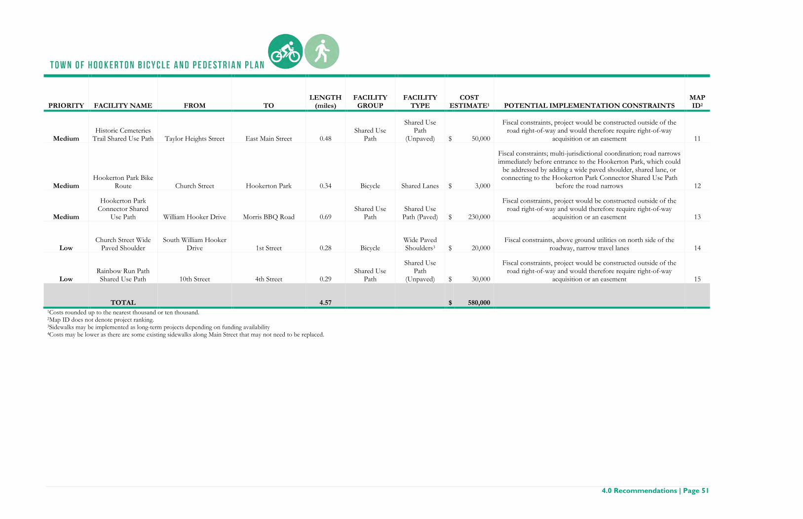
4.0 Recommendations | Page 51
PRIORITY FACILITY NAME FROM TO LENGTH
(miles) FACILITY
GROUP FACILITY
TYPE COST
ESTIMATE1 POTENTIAL IMPLEMENTATION CONSTRAINTS MAP ID2
Medium Historic Cemeteries
Trail Shared Use Path Taylor Heights Street East Main Street 0.48 Shared Use
Path
Shared Use Path
(Unpaved) $ 50,000
Fiscal constraints, project would be constructed outside of the road right-of-way and would therefore require right-of-way
acquisition or an easement 11
Medium Hookerton Park Bike
Route Church Street Hookerton Park 0.34 Bicycle Shared Lanes $ 3,000
Fiscal constraints; multi-jurisdictional coordination; road narrows immediately before entrance to the Hookerton Park, which could
be addressed by adding a wide paved shoulder, shared lane, or connecting to the Hookerton Park Connector Shared Use Path
before the road narrows 12
Medium
Hookerton Park Connector Shared
Use Path William Hooker Drive Morris BBQ Road 0.69 Shared Use
Path Shared Use
Path (Paved) $ 230,000
Fiscal constraints, project would be constructed outside of the road right-of-way and would therefore require right-of-way
acquisition or an easement 13
Low Church Street Wide
Paved Shoulder South William Hooker
Drive 1st Street 0.28 Bicycle Wide Paved Shoulders3 $ 20,000
Fiscal constraints, above ground utilities on north side of the roadway, narrow travel lanes 14
Low Rainbow Run Path Shared Use Path 10th Street 4th Street 0.29
Shared Use Path
Shared Use Path
(Unpaved) $ 30,000
Fiscal constraints, project would be constructed outside of the road right-of-way and would therefore require right-of-way
acquisition or an easement 15
TOTAL
4.57
$ 580,000
1Costs rounded up to the nearest thousand or ten thousand. 2Map ID does not denote project ranking. 3Sidewalks may be implemented as long-term projects depending on funding availability 4Costs may be lower as there are some existing sidewalks along Main Street that may not need to be replaced.

Page 52 | 4.0 Recommendations
Table 4-3: Proposed Bicycle, Pedestrian, and Shared Use Path Spot Facilities
PRIORITY FACILITY NAME/LOCATION FACILITY GROUP FACILITY TYPE COST
ESTIMATE1 POTENTIAL IMPLEMENTATION CONSTRAINTS MAP ID2
High Main Street at 3rd Street Bicycle Parking Bicycle Bicycle Parking $ 500
Fiscal constraints, multi-jurisdictional coordination, existing on-street parking, above ground utilities on all four sides of intersection, fire hydrant on southwest
corner of intersection 16
High Main Street at Contentnea Creek Bicycle
Parking Bicycle Bicycle Parking $ 500 No constraints noted 17
High Main Street at 3rd Street High-Visibility
Crosswalk Pedestrian High-Visibility
Crosswalk $ 6,000 Fiscal constraints, multi-jurisdictional, above ground utilities on both sides of Main
Street 18
High Main Street at N William Hooker Drive
High-Visibility Crosswalk Pedestrian High-Visibility
Crosswalk $ 6,000 Fiscal constraints, multi-jurisdictional coordination, above ground utilities on all four sides of intersection, ditch and no curbs on northeast corner of intersection 19
High
Additional street lighting located along the loop bound by: Stephenson Street, 6th Street,
and West Green Street Pedestrian Street Lighting $ 16,000 Fiscal constraints, coordination with utilities 20
High Main Street at N William Hooker Drive Bicycle Bicycle Maintenance
Station $ 1,000 Fiscal constraints, multi-jurisdictional coordination, above ground utilities on all four sides of intersection, ditch and no curbs on northeast corner of intersection 21
High Main Street/NC 123 Bicycle Bicycle Lane Signage $ 200 No constraints noted 22
High NC 123/N William Hooker Drive Bicycle Bicycle Lane Signage $ 200 No constraints noted 23
High William Hooker Drive at Contentnea Creek Bicycle Bicycle Parking $ 500 No constraints noted 24
High William Hooker Drive at Stephenson Street Pedestrian High-Visibility
Crosswalk $ 3,000 Fiscal constraints, multi-jurisdictional coordination, above ground utilities on west
side of intersection, intersection does not have ADA accessible curbs 25
High William Hooker Drive at Stephenson Street Bicycle Bicycle Parking $ 500 Fiscal constraints, multi-jurisdictional coordination, above ground utilities on west
side of intersection 26

4.0 Recommendations | Page 53
PRIORITY FACILITY NAME/LOCATION FACILITY GROUP FACILITY TYPE COST
ESTIMATE1 POTENTIAL IMPLEMENTATION CONSTRAINTS MAP ID2
High Wayfinding at Hookerton Family Practice Pedestrian Wayfinding $ 500 No constraints noted 27
Medium 4th Street at Main Street Pedestrian High-Visibility
Crosswalk $ 12,000
Fiscal constraints, multi-jurisdictional coordination, above ground utilities on all four sides of intersection, fire hydrant on southeast corner of intersection,
intersection does not have ADA accessible curbs 28
Medium Hookerton Recreation Park Bicycle Bicycle Parking $ 500 Requires coordination with Hookerton Recreation Park for siting the bicycle
parking 29
Medium Morris BBQ Road Bicycle Bicycle Lane Signage $ 200 No constraints noted 30
Medium Pedestrian Bridge over Contentnea Creek at
4th Street Shared Use Path Shared Use Bridge $ 300,000
Fiscal constraints, pedestrian bridge design would need to address the existing utility crossing of Contentnea Creek, would require acquisition or easements to use
private right-of-way 31
Medium Shared use path intersections with roads Shared Use Path Access Points $ 18,200 Would require acquisition or easements to use private right-of-way 32
Medium William Hooker Drive at Mill Street Pedestrian High-Visibility
Crosswalk $ 3,000
Fiscal constraints, multi-jurisdictional coordination, above ground utilities on all four sides of intersection, fire hydrant on northeast corner of intersection, does not
have ADA accessible curbs 33
Medium William Hooker Drive at Greene Street Pedestrian High-Visibility
Crosswalk $ 3,000
Fiscal constraints, multi-jurisdictional coordination, above ground utilities on all four sides of intersection, fire hydrant on northeast corner of intersection, does not
have ADA accessible curbs 34
Medium William Hooker Drive at Ormond Street Pedestrian High-Visibility
Crosswalk $ 3,000 Fiscal constraints, multi-jurisdictional coordination, above ground utilities on east
side of intersection 35
Low Wayfinding at William Hooker Drive at
Contentnea Creek Pedestrian Wayfinding $ 500 No constraints noted 36
Low Wayfinding at Hookerton Historic Cemetery Pedestrian Wayfinding $ 500 No constraints noted 37

Page 54 | 4.0 Recommendations
PRIORITY FACILITY NAME/LOCATION FACILITY GROUP FACILITY TYPE COST
ESTIMATE1 POTENTIAL IMPLEMENTATION CONSTRAINTS MAP ID2
Low 1st Street at Main Street Pedestrian High-Visibility
Crosswalk $ 3,000 Fiscal constraints, multi-jurisdictional coordination, above ground utilities on all
four sides of intersection, fire hydrant on southwest corner of intersection 38
Low Church Street at N William Hooker Drive Pedestrian High-Visibility
Crosswalk $ 6,000 Fiscal constraints, multi-jurisdictional coordination, above ground utilities on all
four sides of intersection, fire hydrant on southeast corner of intersection 39
TOTAL
$ 384,800
1Costs have been rounded to the nearest hundred or thousand. 2Map ID does not denote project ranking.

� � � � � � �� � � �
� � � � �� �� � � � � � � � � � � � � � � � !
" # $ % & $ % $ & ' " ( & & )*+,-..-/012234565
7 8 8 9 : ; < 8 => : ? ; : @ < A 8 =B @ ; 9
C D ' E $ F %G
H IJ D ' E $ F % KL M N
O
H P
H MH G
H QM H
M M
M NM G
M Q M LN P
R S T
U " V # W % &X # Y ' Z V # ' [F % ( & ' \J ' % & ( ] # [ ^_ ' ( )` # # ) & ( % # $ a # b $ X E \ E % cd ( & & $ & " # W $ % ^
Town ofHookerton
e E Y ^ Y Z & _ ' ( ) E $ fe E Y ^ Y Z & D ' E $ % & $ ' $ Y & F % ' % E # $e E Y ^ Y Z & X ' $ & F E f $ ' f &_ ' g & [ F h # W Z [ & (F h ' ( & [ X ' $ &e E Y ^ Y Z & X ' $ &
i i j k li j m k l n o p q rs t u v w t x yz y { v w| } ~ t �� v � } u x w v� x � � x w x v
� { } � � x v� { w t ~ y � �� { w w { � � { {� � � � � � � � � � � �
� } } � { � t } w

� � � � � � �� � � �
� � � � �� �� � � � � � � � � � � � � � � � !
"#$%&&%'()**+,-.- / 0 1 2 3 4 5
6 7 7 8 9 : ; 7 <= 9 > : 9 ? ; @ 7 <A ? : 8
B C 3 5 D 3 5 3 D 1 B E D D FG 0 1 2 3 4 5/ B H I E J H 4 5K
LM M N O NM P
Q R Q SQ L4 5 D T H D 3 U C 3 4 5
O OO VO S
O PO K O LQ N
W X YZ B [ C I 5 D\ C J 1 ] [ C 1 ^4 5 E D 1 _G 1 5 D E ` C ^ ab 1 E Fc C C F D E 5 C 3 d C e 3 \ 2 _ 2 5 Uf E D D 3 D B C I 3 5 a
Town ofHookerton
c 2 g H h i 2 U 2 ` 2 ] 2 5 a B E C U U e 1 ] FG 1 a j 2 3 ^ 2 3 g4 5 E D D 5 \ 2 g H 5 2 3 g4 2 ^ D e 1 ] Fb 1 k D ^ 4 H C I ] ^ D E
l l m n ol m p n o q r s t uv w x y z w { |} | ~ y z� � � w �� y � � x { z y� { � � { z { y
� ~ � � � { y� ~ z w � | � �� ~ z z ~ � � ~ ~� � � � � � � � � � � �
� � � � ~ � w � z
Z C 5 D U � 4 D D / � H 2 ` 2 5 � h � j C E / � 2 U 5 2 3 g � 1 J 2 ] 2 5 2 D U �2 3 J ] I ^ 2 3 g D � 2 U 5 2 3 g U 2 ^ D e 1 ] F J C 3 3 D J 5 2 C 3 U �
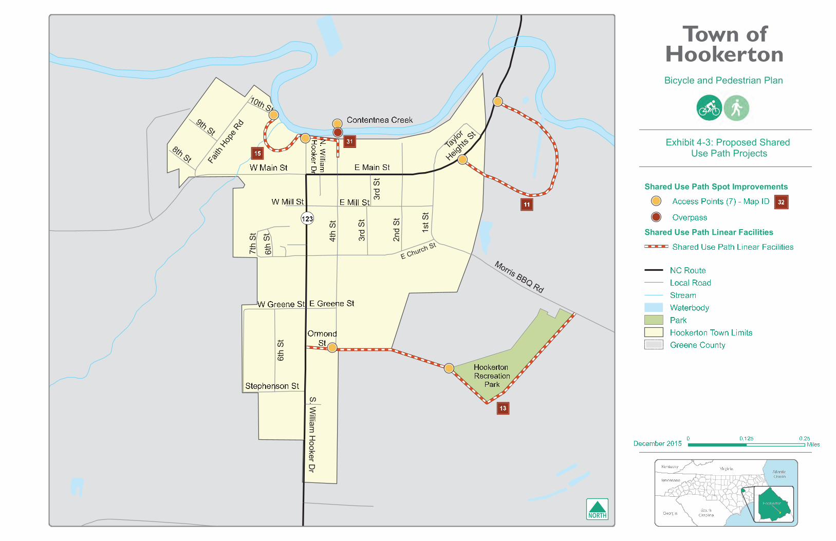
� � � � � � �� � � �
� � � � �� �� � � � � � � � � � � � � � � � !
" # $ % & ' ( )*+,--,./01123454
6 7 7 8 9 : ; 7 <= 9 > : 9 ? ; @ 7 <A ? : 8
B C & ( D & ( & D $ B E D D FG G
G H
G I H G J # $ % & ' (
' ( D K L D & M C & ' (
N O PQ B R C S ( DT C U $ V R C $ W' ( E D $ X" $ ( D E Y C W Z[ $ E F\ C C F D E ( C & ] C ^ & T % X % ( M_ E D D & D B C S & ( Z
Town ofHookerton
` U U D M M [ C % & ( M a b c d # $ K e fg h D E K $ M M' L $ E D W i M D [ $ ( L T % & D $ E j $ U % V % ( % D M
k k l m nk l o m n p q r s tu v w x y v z {| { } x y~ � � v �� x � � w z y x� z � � z y z x
� } � � � z x� } y v � { � �� } y y } � � } }� � � � � � � � � � � �
� � � � } � v � y
H �

E Church St
Morris BBQ Rd
S. W
illiam H
ooker Dr
N. W
illiam
Hooker D
r
Hookerton Recreation
Park
E Main St
Conte
ntne
a Cre
ek
Stephenson St
123
NC Route
Local Road
Stream
Waterbody
Park
Town Limits
Greene County
Bicycle and Pedestrian Plan
Exhibit 4-4: Proposed Bicycle and Pedestrian Network
Proposed Network
Bicycle Spot Improvements
Pedestrian Spot Improvements
Shared Use Path Spot Improvements
Bicycle and Pedestrian Linear Facilities
Bicycle Linear Facilities (only)
Shared Use Path Linear Facilities
Existing Facilities
Sidewalk
Shared Use Path
0 0.250.125Miles
Atlantic Ocean
SouthCarolina
Virginia
Georgia
Kentucky
Tennessee
December 2015
Hookerton
Community FeaturesCommercial
Education
Government
Historic/Cultural
Parks/ Recreation
Place of Worship
Points of Interest
Post Office
Public Safety/Health

4.0 Recommendations | Page 61
Signature Projects 4.3
Main Street Improvements
Main Street in Hookerton is the heart of the community and home to the majority of the community facilities in Hookerton. The Steering Committee and local officials noted that Main Street already has a fair amount of pedestrian and bicycle traffic. Main Street is also the first impression of Hookerton for visitors and those passing through the community. Based on these factors, it is not surprising that the bicycle and pedestrian projects along Main Street were the highest ranked projects in this Plan and had some of the greatest community interest. Making these improvements to Main Street will make the street a more complete street by providing access to all modes of transportation and improve the safety that citizens and visitors need to reach the community destinations located along this corridor. The following tables (Table 4-4 and Table 4-5) provide a high level summary of the proposed linear and spot improvements along Main Street. This project is shown on Exhibit 4-5.
Town Hall on Main St, Hookerton NC AECOM

Page 62 | 4.0 Recommendations
Table 4-4: Main Street Linear Projects
PROJECT NAME DESCRIPTION DISTANCE COST BENEFIT
Main Street Sidewalk
Repair and complete gaps to existing sidewalk
infrastructure from William
Hooker Drive to 3rd Street 0.14 miles $80,000*
• Upgrades existing sidewalk to ADA standards
• Wide sidewalks are recommended to accommodate the commercial area, which is also identified in the Downtown Hookerton Plan
• Completes links to existing sidewalks west of William Hooker Rd and east of 3rd Street
Main Street Bike Lanes and Shared
lanes
Install Bike Lanes from William
Hooker Drive to 1st Street and
Shared Lanes from 1st Street to Town
Limits 0.43 miles $7,000*
• Provides bicycle facility connection between multiple community facilities, which is also identified in the Downtown Hookerton Plan
• Improves safety of bicyclists along one of the most heavily traveled roads in Hookerton
• Offset or extra space between parallel parking and travel lanes provides additional area for bicycle facilities
*Costs are estimates and can vary widely

4.0 Recommendations | Page 63
Table 4-5: Main Street Spot Improvements
SPOT IMPROVEMENT
S LOCATION COST BENEFIT High-Visibility
Crosswalk Main Street at 4th
Street $12,000* Provides connection to proposed pedestrian bridge and the Rainbow Run SUP
High-Visibility Crosswalk
Main Street at N. William Hooker
Drive $6,000*
Provides connection to the Contentnea Creek boat launch and dock and the proposed Rainbow Run SUP
Bicycle Parking
Boat Launch at E. Main Street and
Contentnea Creek $500*
Provides bicycle parking at the Contentnea Creek boat launch and dock and the proposed Rainbow Run SUP
High-Visibility Crosswalk
Main Street at 3rd Street $6,000*
Provides connection from Town Hall to parking spaces on the south side of Main Street and along 3rd Street
Bicycle Parking Main Street at 3rd
Street $500* Provides bicycling parking near Town Hall, Post Office, and local businesses
Bicycle Maintenance Station
Main Street at N. William Hooker
Drive $1,000*
Provides a place in town for cyclists to make repairs to their bicycles and attracts cyclists to visit Hookerton
High-Visibility Crosswalk
Main Street at 1st Street $3,000
Provides connection to existing sidewalk to Mt. Calvary FWB Church and School
Bicycle Lane Sign Main Street $200* Increases the awareness of bicyclists by vehicular drivers
*Costs are estimates and can vary widely

Page 64 | 4.0 Recommendations
Benefits of Signature Projects
• Improves safety of pedestrians and cyclists in Hookerton • Expands accessibility to historic sites, ecological resources, government services, and retail
businesses • Increases opportunities for active living, which improves the quality of life for residents • Enhances the aesthetics of Main Street which will be positive for tourism and local businesses
Constraints of Signature Projects
• Existing safety concerns for bicyclists and those utilizing on-street parking along Main Street has caused accidents such as vehicles backing into cyclists or cyclists side-swiping open vehicle doors
• Costs or funding of the projects • Potential Right-of-Way limitations for bicycle and pedestrian facilities • Utility poles may block sight distance of pedestrians and bicyclists and may need to be
relocated to improve safety
Opportunities of Signature Projects
• Increase tourism associated with historic sites and ecological resources o A pedestrian friendly Main Street may encourage people to stay longer in Hookerton
who are utilizing the boat ramps and fishing pier or who are visiting the historic markers
o Partner with organizations to develop events in Hookerton that utilize the parks and roads in the community (e.g. paddle-thon down Contentnea Creek, a bike or foot race that includes a route in or through Hookerton)
• Improve community health and well-being o Pedestrian and bicycle facilities will provide opportunities for the community to make
active lifestyle choices o Create a walking club to encourage community members to walk more regularly o Define and publish markers in the community for suggested walking routes and their
respective distances to community destinations o Partner with the local school to encourage local students to walk

Town of Hookerton
��������������� � � � � � �� � � � � � � � � � � � � � �
���� ��� ���� ���� !� ���" �!� ���� ��������������# � � � � � � $ % &' ( ) *
+ ,-. /
0 1 2 34
Project Group Facility Type Project Name/Location
Bicycle Facility Bicycle Lane Main Street
Bicycle Facility Bicycle Shared Lane Main Street
Bicycle Facility Bicycle Parking Main Street at N William Hooker Dr
Bicycle Facility Bicycle Parking Main Street at Contentnea Creek
Bicycle Facility Bicycle Parking Main Street at 3rd Street
Bicycle Facility Bicycle Maintenance Main Street at N William Hooker Dr
Bicycle Facility Bicycle Lane Signage Main Street/NC 123
Pedestrian Facility Sidewalk Upgrades Main Street
Pedestrian Facility High-Visibility Cross Walk Main Street at 1st Street
Pedestrian Facility High-Visibility Cross Walk Main Street at 3rd Street
Pedestrian Facility High-Visibility Cross Walk Main Street at 4th Street
Pedestrian Facility High-Visibility Cross Walk Main Street at N William Hooker Dr
Goals of Signature Projects
Improve safety through completing bicycle and pedestrian connections to be compliant with ADA standards along one of the most heavily traveled roads in Hookerton.
Active living principles can be addressed
visitors experience from improved bicycle, pedestrian, and shared-use path for new or upgraded facilities.
Through infrastructure improvements, positive impacts to the economic and transportation
corridor can be achieved. These facilities can also encourage recreational tourism for visitors traveling to or through Hookerton.
Promote community and environmental stewardship through providing better access to outdoor facilities and to encourage the use of more environmentally friendly transportation choices.
Create social spaces for the Hookerton community to enjoy for leisure and recreation, helping to encourage public interaction and use
5 6 7 8 7 9 : ; < : = > 7 6 ?@ A B C B D E F G H I J K G L H M E K E N I OP E Q E O I L A R N F G H I J K G L H M E K E N I OF S R L E Q T O E P R I S F G H I J K G L H M E K E N I O@ A B C B D E R N Q P E Q E O I L A R N U A N E R L V R B A D A I A E O@ A B C B D E U A N E R L V R B A D A I A E O W H N D C XF S R L E Q T O E P R I S U A N E R L V R B A D A I A E OY Z [ 9 = [ \ ] ^ _ ` [ a [ = [ : 9F A Q E b R D cF S R L E Q T O E P R I S

4.0 Recommendations | Page 67
Establish Regional Bike Routes
The relatively flat terrain of Eastern North Carolina makes it an ideal setting for recreational bicycling. There are several established bike routes near Hookerton that are recognized by NCDOT that have designated route markers. However, none of these official routes pass through Hookerton. Aside from these routes, the Greene County CTP designates bike routes in Greene County where none have official designation. These undesignated bike routes do pass through Hookerton, following the route of NC 123. Community members expressed an interest of connecting the Town of Hookerton to formal bike routes. Regional bike routes are shown on Exhibit 4-6.
Recommended Steps • Work with Greene County, the ECRPO, and NCDOT to determine a process for officially
designating roadways as bike routes in Greene County • Develop potential routes that build upon the existing routes identified in the Greene County CTP
o Consider themes for routes, such routes that connect food destinations, ecological sites, or historical Civil War sites
o Connect to other established routes, such as the Mountains to Sea Trail • Officially designate the routes by:
o Marking the routes with signs along the roadways o Creating maps and/or a brochure that can be distributed online, through bicycling
organizations, and at visitor centers • Advocate for improvements to the roadways along designated routes to improve the safety of the
bicyclists on the roadway
Beaverdam Run Multi-use Trail, Hookerton NC AECOM, 2015
Example of standard shared bicycle lane signage CityPhile, 2011

Page 68 | 4.0 Recommendations
Benefits of Regional Bicycle Routes
• Increases driver awareness of bicyclists on the roadway • Improves safety for bicyclists
Constraints of Regional Bicycle Routes
• Regional coordination efforts • Capacity of staff • Cost and funding
Opportunities of Regional Bicycle Routes
• Increase tourism in Hookerton o Being on a designate bike route will increase the number of bicyclists that are likely to
pass through Hookerton o Having facilities in Hookerton for bicyclists (e.g. bike lanes, bicycle parking, and a
bicycle repair stand) will increase the likelihood of bicyclists spending time in Hookerton
o Partner with organizations to develop a bike ride or race that utilizes the routes that pass through Hookerton
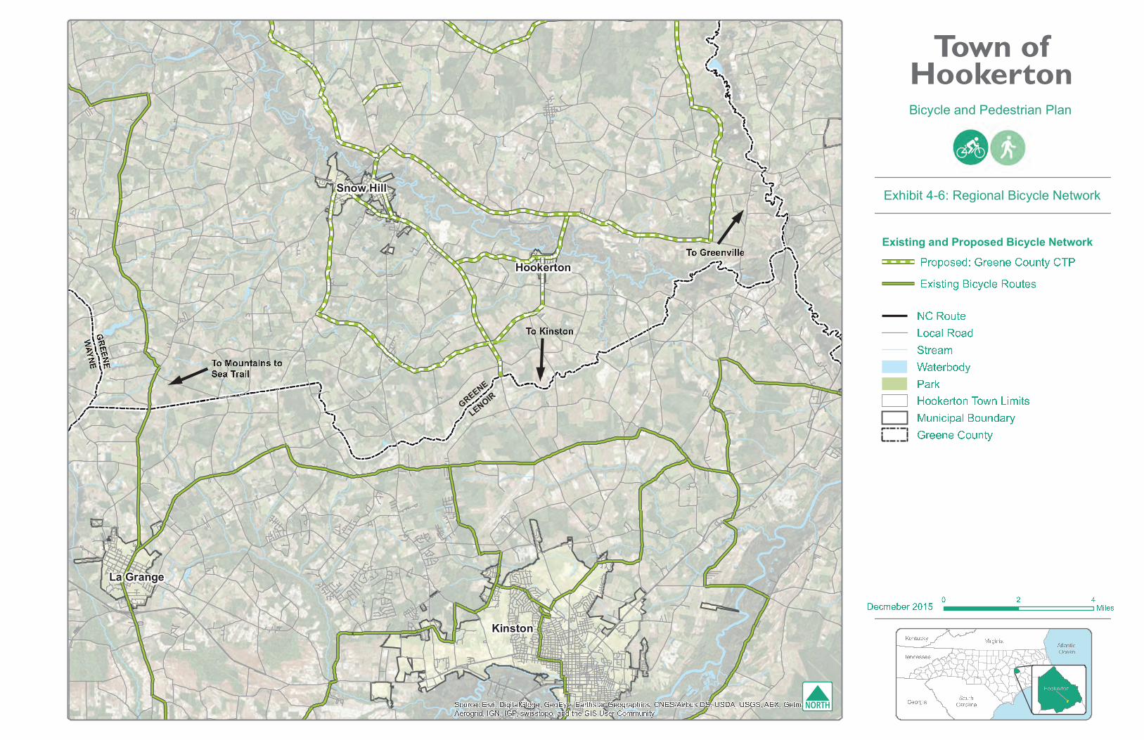
� � �� � � �� � � � � � � � � � �� � � �� � � � � � � � � � !" #$ % & ' ' ( ' ) * + , - . . / . 0 1 23456789:;< = > ? = @ A B C A DEFGHIJKLJ M N O P Q RS T U V W X Y Z X[\]̂\_ ` a b c d ef6g56 hijki lm656n o p o q r s t u r v s ow x t n y t u z
n o { y x x r | u z z xn o } u r v s o r~ � � � � �� � � � �
� � � � � � � � � � � � � � � � � � � � � � � � � � � � � � � � � � � � � � � � � � � � � � � � � � � � � � � � � ¡ � � � � � � � � ¢ � � ¡ � ¢ � � � � ¡ � £ � � � � ¤ � � � � ¥ � �¡ � � � � � � ¦ � § � � � § � ¨ � � © � � � � � � � � � ¥ ¦ � � � � § � ¢ � � � � � ¤ ¤ � ¥ � � �
ª « ¬ ® ¯ °± ² ³ ´ ¬ ³ µ¶ ¯ · ° ³ ¸¹ ³ ¯ ° · º µ »¼ ³ · ½¾ ½ ° · ¯ ¿ À Á ¿ ±  ¸  ¯ ÃÄ ® ¿  ²  Š³ ´ Æ ® ¿ µ ³ · »Ç · ° ° ¿ ° « ® ¿ ¯ »
Town ofHookerton
¼ · Å Ã ° µ È Ç · ° ° ¿ ° « ® ¿ ¯ » « À ¼É Ê Â Ã ¯  ¿ Ë Æ Â ² » ² ´ ° ¬ ® ¯ ° Ã
Ì ÍÎ Ï Ð Ñ Ò ÓÔ Õ Ö × Ø Õ Ù ÚÛ Ú Ü × ØÝ Þ ß Õ àá × â Þ Ö Ù Ø ×ã Ù â ä Ù Ø Ù ×
å Ü Þ â ä Ù ×æ Ü Ø Õ ß Ú ç èé Ü Ø Ø Ü ê ê Ü Üë ì í î ì ï ì ð ñ ò ó ô
õ Þ Þ ç Ü â Õ Þ Ø

4.0 Recommendations | Page 71
Policies 4.4
In 1992, NCDOT expanded its original bicycle program and created the Division of Bicycle and Pedestrian Transportation. The following year, the office was allocated the first funds specifically for pedestrian projects. Since its inception, NCDOT has initiated policies, programs, and guidance that aim to improve the pedestrian environment and make walking a viable mode of transportation. 3 Bicycles are allowed on all federal, state, and secondary roads, except on freeways with limited access. Any policies and procedures relating to these roads may have an impact on bicycles.
Policies and procedures that may impact walks, trails, and complete streets are as follows:
The Americans with Disabilities Act (ADA) (1990): Requires the use of physical elements such as paved walkways, ramps with handrails, curb cuts and ramps, and minimum width standards to make pedestrian networks accessible to all users. Grades for pathways used by pedestrians cannot exceed five percent unless treated as a ramp, with a maximum slope of over eight percent for short stretches of trail.
Bicycle Policy (1991): Establishes the Board of Transportation recognizing bicycling as a “bonafide highway purpose” with the same rights and responsibilities as other highway purposes.
Board of Transportation Resolution: Bicycling & Walking in North Carolina, A Critical Part of the Transportation System (2000): A resolution to make cycling and walking a critical part of the state’s transportation system through long-range transportation planning.
Pedestrian Policy Guidelines (2001): Provides statewide uniformity in the construction of sidewalks on roadway projects.
NCDOT 2040 Plan (2012): The 2040 Plan defines North Carolina's vision for statewide transportation system.
NCDOT Context Sensitive Solutions Goals and Working Guidelines (1992/1993): Emphasizes three guiding principles: to address the transportation need, be an asset to the community, and to be compatible with the natural and human environment.
NCDOT Complete Streets Planning and Design Guidelines (2012): The policy directs NCDOT to consider and incorporate several modes of transportation when building new projects or making improvements to existing infrastructure.
The North Carolina Rail-Trails (NCRT) (1990): The program monitors the state's rail system, and actively pursues corridor preservation, retrieval, and conversion from abandoned rail corridors to public trails. It provides coordination between local, state, and federal agencies, allied state and national organizations, and project funding sources.

Page 72 | 4.0 Recommendations
WalkBikeNC (2013): The North Carolina Pedestrian and Bicycle Plan was developed in 2013 through a partnership between multiple state agencies and private entities. The Plan reviews the current status of bicycling and walking in this state, strategies for improvement, and identifies the most efficient ways to apply these strategies.
It is based on a five-pillar framework: Mobility, Safety, Economics, Health, and Stewardship. The Town of Hookerton should consider implementing policies and provisions as part of its bicycle and pedestrian initiatives pursuing comprehensive strategies that incorporate bikeability and walkability in all future planning and development decisions.
Strategies recommended include, but are not limited to:
• Implementation of the Complete Streets policy • Formation of a Bicycle and Pedestrian Advisory Committee or appointment of a single council member,
citizen liaison, or advocate for bicycle and pedestrian activities • Coordination with neighboring jurisdictions to expand the regional network of bike routes • Annual review of the implementation of programs and projects recommended by this Plan
Additional Policy Recommendations: Including safe and alternative options to vehicular use can help encourage residents to walk or bike for both transportation and leisure purposes. Redevelopment and new development permitted in Hookerton should provide for cycling and walking facilities. The Town Council can encourage bicycling and pedestrian activity by:
• Requiring bicycle and pedestrian facilities in all new development • Promoting expansion of bicycle and pedestrian amenities on roadways • Requiring bicycle and pedestrian facilities on all roadway improvements • Promoting bicycle, pedestrian, and shared use path connectivity in Hookerton and surrounding
communities
The Town should adopt land use and zoning amendments that comply with bicycle, pedestrian, and land use policies. Hookerton should promote a more bicycle and pedestrian-friendly environment in and around new infill development, redevelopment, and natural areas.
Requirements for new bicycle and pedestrian infrastructure should be consistent throughout the Town’s planning jurisdiction as follows:
• Signage policies that designate bike usage on roadways. This is an important measure to increase driver awareness of cyclists for improved safety
• Encourage commercial development that incorporates Complete Streets policies for use by both cyclists and pedestrians
• All new office/institutional/commercial and residential developments should provide sidewalks, provide buffering from vehicular traffic and off-street parking lots, and provide trees that will shade sidewalks

4.0 Recommendations | Page 73
• Trees, utility poles, and street furniture shall not be placed where they may hinder the view from pedestrian crosswalks and intersections
• When an existing sidewalk or path is closed for construction or maintenance reasons – on the walkway itself or on adjacent property – an adequate detour route should be established and signed if feasible
• All local, state, and federal road and bridge project planning and construction projects must include reasonable non-motorized accommodation for both bicycles and pedestrians. According to NCDOT policy, 5 to 6 foot-wide sidewalks shall be included on new bridges, and a determination on providing bicycle lanes or sidewalks on one or both sides of new bridges will be made during the planning process according to the NCDOT Pedestrian Policy Guidelines. NCDOT shall fund all or part of the cost of sidewalks or wide paved shoulders when they are mapped and recommended as part of a transportation plan
• All walkways and shared use paths must be ADA accessible
Local Ordinance Recommendations Currently, there are no provisions or standards in the Town’s current Development Ordinance specific to bicycle or pedestrian facilities. The Town should modify its Ordinance to include and require that bicycle, pedestrian, and shared use path facilities are consistent with standards contained in this Plan in an effort to provide bicycle and pedestrian-oriented development.
General Bicycle Recommendations
Bicycle infrastructure including bike lanes, paved shoulders, shared and marked lanes, and shared use paths should have designated signage to help direct cyclists and enforce motorists of common roadway use. Signage and shared lane markings become an important measure for enforcement when bicycle infrastructure is planned. Local ordinances should be used to require these measures for improved bicycle facilities and consider implementing standards for storage and parking for cyclists where feasible.
Typical Roadway Section showing Bicycle and Pedestrian Facilities NCDOT

Page 74 | 4.0 Recommendations
It is recommended that bicycle lane facilities be 4 to 6 feet at a minimum. For designated bike lanes with on street parking, the bike lane should be 5 feet at a minimum, and where parking is prohibited the bike lane should be 4 feet in width at an absolute minimum. Paved shoulders are recommended to be 4 feet wide at a minimum and should include pavement markings. Where speeds are 55 mph and above, paved shoulders should be 5 feet wide at a minimum. Designated bike lanes are ideal for streets with heavy vehicle traffic as it provides improved safety measures. Bicycle lanes at intersections should be included in the design and development of potential future facilities. According to AASHTO recommendations, typical shared lanes with on street parking should be placed at 11 feet from the face of curb. Streets without on street parking, shared lane markings should be at least 4 feet from the face of curb at a minimum.
General Sidewalk Recommendations
Sidewalks should be clear of obstructions such as utility poles, sign posts, fire hydrants, bike racks, newspaper stands, etc. These objects should be placed elsewhere, such as a planting buffer strip. Other standards contained in Appendix C: Design Guidelines should be incorporated into the Development Ordinance. Vertical clearance should be at least 7 feet from ground level to the bottom edge of signs or the lowest tree branches.
It is recommended sidewalks be a minimum of 5 feet in width, a specification based off sidewalk width requirements NCDOT and ADA recommends (AASHTO, 2012). NCDOT Division of Highways requires sidewalks standards no less than what is required by the American with Disabilities Act (ADA), which require widths of a minimum of 3 feet for a maximum of 200 feet in length, where level areas of 5x5 feet must be available for wheelchairs to be able to pass and reverse direction. ADA standards also restrict cross slopes of more than 2 percent. For these reasons, NCDOT’s Division of Bicycle and Pedestrian Planning has its own Design and Construction Standards (Section 6.3.1). These standards recommend 5 feet minimum width for planting strips or buffers between curbs and sidewalks. This prevents excessive cross slopes that would otherwise occur where a driveway meets a sidewalk adjacent to the curb.
Typical Roadway Section showing Bicycle Sharrows AASHTO

4.0 Recommendations | Page 75
General Shared Use Path Recommendations
Shared use paths should accommodate both bicyclists and pedestrians through adequate widths that consider passing needs and different uses. Drainage, lighting, signage, and slope should all be considered for accessibility of shared use paths.
Paths should be 10 feet in width to accommodate both bicyclists and pedestrians including enough space for bicyclists to pass another user in the same direction (NCDOT, 2007). Access points and crossings should be visible to both road users and path users with sight lines maintained for visibility. A path should have a graded (sloped) area of at least 3 ft. to accommodate drainage and vegetation. The MUTCD (FHA standard highway signs and markings) requires a minimum of 2 feet of horizontal clearance from the edge of the path to post mounted signs or other traffic control devices. Shared use paths should be ADA compliant, including access points. These and other standards should be incorporated into future Development Ordinances for the Town of Hookerton.
Typical Shared Use Path AASHTO

Page 76 | 4.0 Recommendations
Programs 4.5
Bicycle and Pedestrian Advisory Committee, Council Member, Citizen Liaison, or Advocate A BPAC or appointment of a single council member, citizen liaison, or advocate for bicycle and pedestrian activities should be formed or appointed to continue bicycle and pedestrian planning efforts and program implementation in Hookerton.
A committee or appointee(s) could include existing/an existing Steering Committee member(s) and/or additional residents concerned about bicycle and pedestrian issues and needs in the community. Membership of the BPAC or an appointee(s) should reflect the demographic makeup of the Town in terms of age, race, and socioeconomic status. Representatives from community groups, schools, and businesses should be included.
The BPAC or appointee would be charged with the principal objective of advocating for bicycle and pedestrian safety and mobility through education, encouragement, and enforcement campaigns and infrastructure projects. This should include research funding opportunities, assist with submission of grant applications, and a role in selecting and monitoring the work of consultants designing and contractors constructing bicycle and pedestrian infrastructure. It would also serve to form partnerships between schools, businesses, and surrounding town and cities including Snow Hill Ayden, and Greene and Lenoir counties.
The BPAC or appointee should meet regularly and provide updates to the Hookerton Town Council. In addition to helping implement proposed projects the promotion of education, safety, encouragement, enforcement and evaluation, events, and beautification programs should be a priority.
Education
Education is essential for teaching and reminding drivers of all ages the applicable laws and responsibilities of motorists as they pertain to safely sharing the road with bicyclists and pedestrians. This also includes educating police officers on bicycle and pedestrian safety and laws.
Although children aged 5 to 15 are not yet old enough to drive, it can be expected that the majority will become automobile users. Educating elementary and middle school students (the future driving population) about bicycle and pedestrian safety provides excellent opportunity to make a difference in a two-fold manner.

4.0 Recommendations | Page 77
Pedestrian safety, as well as how to safely maneuver an automobile while in the presence of pedestrians and bicycles can be an instrumental part of any driver’s education program in Hookerton. This training will allow this new generation to be more aware of the simple fact that motorized vehicles do not have sole right to the transportation network, and it is everyone’s responsibility to be careful when in the roadways.
More information can be found at http://www.ncdot.gov/dmv The NC Bicycle and Pedestrian laws can be found at http://www.ncdot.gov/bikeped/lawspolicies/laws
Bicycle and Pedestrian Education
Many bicycle and pedestrian crashes occur because a traffic law(s) was disobeyed. Crossing signalized intersections on the red phase, bicycling or walking on the roadway in the same direction as traffic, and darting across traffic lanes are not only dangerous, they are illegal.
There is often confusion about the direction a bicyclist should ride when using on-road facilities. Bicyclists are legally expected to ride with the flow of traffic because a bicycle is deemed a vehicle according to the Motor Vehicle Laws of North Carolina. Similarly, cyclists must stop at stop signs and red lights like any roadway user. Lights and other reflectors should be used at night or during inclement weather, the law requires a headlight and rear light for bicyclists. Passing and turning when using a bicycle should use signal turns with arms and hands. There are many resources regarding bicycle education online for distribution purposes.
Indeed, much of the reasoning why a pedestrian breaks the law is because of conditions unknown to the motorist such as the scarcity of proper crossing locations or the absence of walkways out of the roadway. Unfortunately, many pedestrians take unnecessary risks, may not know which traffic laws apply to them, or actively choose not to follow the law. In addition to creating safe walking areas for pedestrians, walkers must be taught to respect the laws for their own safety. Pedestrian education courses should be offered at schools, libraries, or on informational web sites.
There are national sources to help provide input for bicycle and pedestrian education. A few of these include: Pedestrian and Bicycle Information Center: http://www.pedbikeinfo.org/programs/education.cfm Designing Sidewalks and Trails for Access:
• Part I of II: Review of Existing Guidelines and Practices http://www.fhwa.dot.gov/environment/bicycle_pedestrian/publications/sidewalks/
• Part II of II: Best Practices Design Guide https://www.fhwa.dot.gov/environment/bicycle_pedestrian/publications/sidewalk2/
League of American Bicyclists Bicycle Education: http://www.bikeleague.org/programs/education/
Bicycle and Pedestrian Crossing Flickr Creative Commons, RDVRSA, 2008

Page 78 | 4.0 Recommendations
Watch for Me NC
With more than 2,400 pedestrians and 960 bicyclists hit by each vehicles each year in North Carolina, NCDOT in collaboration with municipalities and universities has launched the Watch For Me NC campaign to reduce crashes through education and enforcement. Education materials in the form of a website, public service announcements, pamphlets, bus wraps, billboards, and bumper stickers have been developed and distributed to increase awareness of pedestrians and bicyclists and applicable laws. The campaign also provides increased training to law enforcement. Sedalia may coordinate with the City of Greensboro, which has participated in the Watch for Me NC campaign.
Many of these resources are downloadable from the More information can be found at Watch for Me NC: http://www.watchformenc.org/
Safety
Bicycle Helmet Initiative
Facilitated by NCDOT’s Department of Bicycle and Pedestrian Transportation (DBPT), the Initiative works to reduce bicycle related accidents of children through the promotion of helmet use, developing proper usage into and through adulthood. The DBPT supports local agencies and schools to encourage the program, offering a maximum of 24 helmets per year to each involved organization or group.
Let’s Go NC - Bicycle and Pedestrian Curriculum
Aimed to instruct children between grades k-5, the program focuses on walking and biking safety and skills. As a way to promote healthy and active lifestyles, a curriculum was developed that includes aspects of the Safe Routes to School program, and classroom, video, and exercise materials.
More information can be found at: https://connect.ncdot.gov/projects/BikePed/Pages/LetsGoNC.aspx
Safe Routes to School
Safe Routes to School (SRTS) is a program that enables and encourages children to walk and bike to school. The program helps make walking and bicycling to school a safe and more appealing method of transportation for children. SRTS facilitates the planning, development, and implementation of projects and activities that will improve safety and reduce traffic, fuel consumption, and air pollution in the vicinity of schools.

4.0 Recommendations | Page 79
The North Carolina Safe Routes to School Program is supported by federal funds through SAFETEA-LU and MAP-21 legislation. Please note that all SRTS projects “shall be treated as projects on a Federal-aid system under chapter 1 of title 23, United States Code.” Although no local match is required and all SRTS projects are 100% federally funded under the SAFETEA-LU, agencies are encouraged to leverage other funding sources that may be available to them, including grant awards, local, state, or other federal funding. SRTS funds can be used for proposed projects that are within 2 miles of a school public or private, K-8, in a municipality or in the county jurisdiction. In response to the Strategic Transportation Investments law of June 2013, proposed SRTS projects will be considered as part of the Bicycle and Pedestrian project input with Strategic Prioritization Office for funding consideration. Most of the types of eligible SRTS projects include sidewalks or a shared-use path. However, intersection improvements (i.e. signalization, marking/upgrading crosswalks, etc.), on street bicycle facilities (bike lanes, wide paved shoulders, etc.) or off-street shared-use paths are also eligible for SRTS funds. For a more inclusive list, please visit the FHWA SRTS program at: http://www.fhwa.dot.gov/environment/safe_routes_to_school/overview/
The general steps of a SRTS Program are outlined below by the North Carolina Division of Bicycle and Pedestrian Transportation:
1. Bring the right people together. Identify people who want to make walking and bicycling to school a safe and appealing transportation alternative. Provide a mechanism for a variety of community members to share concerns, interests, and knowledge, which will enable the group to tackle many different issues.
2. Hold a kick-off meeting. The kick-off has two goals: to create a vision for the SRTS program and to generate the next steps to take.
3. Gather information and identify issues. Specific barriers to address through the program will be identified by collecting useful information at the outset. This baseline data also provides a means by which the group can measure its success.
4. Identify solutions. Each issue identified will have a unique solution to address it. Comprehensive solutions will include a combination of engineering, education, encouragement, and enforcement strategies.
5. Make a plan. Every SRTS action plan should include the strategies and solutions identified through step 4 as well as a time schedule to implement them. Plans also should include a map of the area it covers and a process for evaluating and fine-tuning the program.
6. Get the plan and people moving. Some parts of the SRTS action plan can be implemented right away, with little to no funding – take advantage of these opportunities while waiting for other parts, and keep the big picture in mind.
7. Evaluate, adjust, and keep going. As the program is implemented, monitor the impact it is making and gauge the effectiveness of each strategy. Continue ones that are working well, and modify or redirect strategies that are not providing satisfactory outcomes.

Page 80 | 4.0 Recommendations
The Active Routes to School program is a NC Safe Routes to School Project supported by a partnership between the NC Department of Transportation and the NC Division of Public Health. Project coordinators across the state work to make it easier for elementary and middle school students to safely walk and bike to school. The project coordinators work with partners in their communities to increase:
• One-time awareness events about the importance of Safe Routes to School • The number of ongoing programs that encourage walking and biking to or at school • The number of trainings on how to implement Safe Routes to School-related activities. • The number of policies that support walking and biking to or at school. • The number of safety features near schools.
More information can be found at Safe Routes to School National Partnership http://saferoutespartnership.org/state/srts-in-your-state/northcarolina http://www.ncdot.gov/download/programs/srts/srts.pdf More information about the Active Routes to School program can be found at: http://www.communityclinicalconnections.com/What_We_Do/Active_Routes_To_School/index.html
School Safety Patrol Programs
School Safety Patrol Programs across the United States have been responsible for decreased pedestrian/vehicle collisions. The American Automobile Association (AAA), municipalities, and schools have sponsored these important safety programs in the past, and could be implemented at Sedalia Elementary School. AAA offers training and equipment to start safety patrol programs.
More information can be found at: http://exchange.aaa.com/safety/child-safety/aaa%E2%80%99s-school-safety-patrol/
WalkBikeNC: Safety and Health
North Carolina has an overweight/obesity rate of more 65 percent, increasing the risk of disease and adverse health conditions statewide (WalkBikeNC Report, Page 1-7). Through the provision of bicycle facilities, pedestrian paths and sidewalks, alternative routes to school, and improvements to roadway crossings, Hookerton can improve the safety of alternate transit as a way to encourage the physical activity and health of its residents. The WalkBikeNC Plan outlines a series of programs and initiatives that can work in parallel to local and NCDOT efforts to support pedestrian infrastructure.
More information can be found at WalkBikeNC: http://www.ncdot.gov/bikeped/planning/walkbikenc

4.0 Recommendations | Page 81
Enforcement and Evaluation
Essential to pedestrian safety is enforcing existing driving laws and speed limits. It is recommended that the town work with the Greene County Sheriff’s Department to continue to enforce the Town’s speed limits to minimize bicycle and pedestrian related safety concerns.
Pedestrians also have a responsibility to abide by laws pertaining to them such as crossing at crosswalks and walking in the direction of oncoming traffic. Town police should encourage pedestrians to follow the laws in the interest of safety.
Bicycle and Pedestrian Needs Checklist
The Town staff can work to identify improvements on an ongoing basis for the purpose of evaluation and possible enforcement. This includes both identification of bicycle and pedestrian needs but also an opportunity for facility inspection and maintenance. A checklist can be defined using the identification of facilities in this Bicycle and Pedestrian Plan, but should be expanded on an as-needed basis.
Pedestrian Safety Education Campaign
The Guilford County Sherriff’s Department should develop a Pedestrian Safety Education Campaign to place signs along road that remind pedestrians to walk facing traffic. In addition to these signs, a campaign may also include: workshops for motorists and pedestrians on applicable laws and safety and events to raise awareness such as walks.
More information can be found nationally and North Carolina specific at: http://safety.fhwa.dot.gov/local_rural/pedcampaipe/ http://www.ncdot.gov/bikeped/safetyeducation/materials/
Events
Bicycle Rodeos
A bicycle rodeo is a skills event that offers bicyclists an opportunity to develop and practice for becoming a better bike rider. More specifically, the program is designed to help show kids in local neighborhoods how to be safer on bikes. This includes active learning opportunities for improved awareness’ and safety. Often hosted by a municipality, a bicycle rodeo involves skilled instructors that can be identified through schools, law enforcement agencies, and bicycling clubs, who focus on training in bike handling skills and on-street experiences to develop confidence in traffic. The Organizer’s Guide to Bicycle Rodeos provides the fundaments of an effective program and includes organization tools, planning and designing the course(s), and various games that can be played during the event.
More information can be found at An Organizer’s Guide to Bicycle Rodeos http://www.bike.cornell.edu/pdfs/Bike_Rodeo_404.2.pdf

Page 82 | 4.0 Recommendations
Bicycling and Walking Programs
A “Weekend Walkabout” can be coordinated with the NCDOT to bring attention to pedestrian infrastructure and highlight places to walk in the community. The event can be organized around historic sites, park walks, or neighborhood tours. Walking programs offer not only awareness, but also encourages community and/or families to be more physically active. The “Walk to School Day” and the “Bike Month,” both which take place nationally every fall, can also be a used in conjunction to stimulate bicycling and walking in Hookerton. This concept is included in the statewide WalkBikeNC Plan.
More information can be found at WalkBikeNC http://www.ncdot.gov/bikeped/planning/walkbikenc Program recommendations can be found at http://www.walkbikenc.com/plan-resources/#program
Bicycling or Walking Youth Engagement Contest
In the past, the NCDOT helped to host a statewide competition to both educate and engage students about walking and bicycling activities. This has been accomplished through school districts to schedule either audio, visual, or other media forms to market the health and recreational benefits of walking and/or bicycling. Events have been planned around the contest and a final vote on the best educational and promotional final project. This contest is encouraged by the WalkBikeNC Plan.
Bike or Walk to Work, Shop, School and Play Days
Designate a day, a week or month where people walk to their destinations. This can coincide with International Walk to School Week, or with Bike to Work Week, or with another common “Hike, Bike, and Bus” week that some municipalities sponsor. Advertise these events, have some fun events along common pedestrian routes, and offer prizes and recognition for model participants. International Walk to School Week typically falls on the first week of October. Walk to School events can be as simple as a few kids and parents meeting to walk to school or can be very elaborate celebrations. Event logistics range from a central walking location to people walking from their homes. Successful events have the support and participation of the principal, police and parents, and programs such as this give public agencies and representatives the opportunity to publicly support health, environment and safety initiatives.
More information can be found at Walk to School http://www.walktoschool.org/
Bicycle Rodeo Flickr Creative Commons, SLO Bike Rodeo,
2011

4.0 Recommendations | Page 83
Walking Club
The community should institute a community walking club that would help encourage active life styles of residents and use of the community’s pedestrian facilities. The walking club would allow individuals to sign up and keep track of their miles walked. The town could provide suggested routes and the mileage or distances for completing loops or other routes.
The walking club could utilize a number of existing sites that provide these standardized services, such as the American Cancer Society’s Active for Life program and the President’s Challenge Program, more information can be found at the following sites:
https://www.activeforlife.org/ https://www.presidentschallenge.org/
The community could hold special events and partner with other community resources such as schools, churches, and other groups to encourage friendly competition for most miles walked or biked between teams.
Open Street Events
Once some of the recommended projects are constructed, it would create a perfect opportunity for regular special events. A festival could be set up at the Town Hall, at a park, or on a greenway spurring a new experience that may draw more interest in pedestrian facilities.
An international trend is to turn major Town roads into “Sunday Parkways.” This concept takes long strips of roadways (linear or in a looping pattern) and converts one or both directions of traffic to pedestrian malls or for bicycle rides during a portion of every Sunday and holiday. This encourages people to get out and walk or bicycle, increases the amount of public space, and motivates people to walk more often throughout the rest of the week. This concept is included in the statewide WalkBikeNC Plan.
More information can be found at WalkBikeNC http://www.ncdot.gov/bikeped/planning/walkbikenc Program recommendations can be found at http://www.walkbikenc.com/plan-resources/#program
Open Street Bicycle Event Flickr Creative Commons, Umberto Bayj, 2012
Walking Club Flickr Creative Commons, Iain Farrell, 2012

Page 84 | 4.0 Recommendations
Beautification
Adopt a Sidewalk Program
Adopt a Road programs are common, enabling members of the community to sponsor and help to clean a road with litter and other debris. Hookerton can begin a similar program for its sidewalks and multi-use paths once they are built. This program could also be used as a means for the community to alert the Town when there is a maintenance issue with a sidewalk, or as a means for a sidewalk to get special attention, funding, and improvements because of the dedication of its community sponsor. This program will encourage a sense of pride and ownership of the sidewalks, paths and infrastructure for bicyclists and pedestrians.

implementation strategy

5.0 Implementation Strategy | Page 85
5.0 Implementation Strategy
Achieving the vision, goals, and objectives of this Plan will require the commitment of Town Officials and Staff, the Bicycle and Pedestrian Advisory Committee or appointment of a single council member, citizen liaison, or advocate for bicycle and pedestrian activities, the ECRPO and NCDOT, and the support and leadership from the community and other partner organizations. All bicycle and pedestrian facility recommendations along NCDOT-maintained roadways will require review and approval by NCDOT Highway Division 2 prior to implementation. Guided by the goals, objectives, and strategies, the Town will continue working to improve bicycle and pedestrian safety and connectivity.
The implementation strategy for this Plan includes several components to assist with translating this document into implemented programs and constructed bicycle and pedestrian facilities:
• Key Action Steps • Project Development Strategies • Funding Process and Sources • Performance Evaluation Measures
Key Action Steps 5.1
The Bicycle and Pedestrian Advisory Committee (BPAC) or appointment of a single council member, citizen liaison, or advocate for bicycle and pedestrian activities is entrusted with overseeing the implementation of the Plan with assistance from Town Staff and participation by the stakeholders. The BPAC would be responsible for meeting regularly to receive updates and guide progress on the action steps. It would also author the annual progress report on bicycle and pedestrian conditions in Hookerton. The key action steps are listed in Table 5-1.
Table 5-1: Key Action Steps
Step Action Stakeholder Timeline
1 Adopt the Hookerton Bicycle
and Pedestrian Plan Present the Plan to the Hookerton
Town Council for adoption. Town Council and Town Staff Late 2015
2
Establish or appoint a BPAC, single council member,
citizen liaison, or advocate
Form an advisory committee to oversee the implementation of the
Plan. Town Council and Town Staff
Winter 2016

Page 86 | 5.0 Implementation Strategy
Step Action Stakeholder Timeline
3
Strengthen partnerships with Greene County, the ECRPO,
and the Active Routes to Schools Region 10
Coordinator
Hold an initial meeting with the stakeholders to provide an
overview of the Plan’s recommendations and identify opportunities for collaboration.
See Sections 2.7, 4.4, 4.5.
Greene County, ECRPO, and the Active Routes to
Schools Coordinator
Late 2015 and
ongoing
4 Coordinate with NCDOT
Division 2
Hold an initial meeting with NCDOT Division 2 to discuss
how the Plan’s bicycle and pedestrian projects may be incorporated in upcoming
transportation projects, including roadway resurfacing projects that
affect Hookerton, specifically Main Street, William Hooker Drive, and 1st Street. In addition, the Regional
Bicycle Network.
See Sections 4.4, 4.5. NCDOT Division 2 and Town Staff Ongoing
5
Coordinate with ECRPO to include infrastructure
projects in the regional planning process
Hold an initial meeting with ECRPO to review the Plan’s
infrastructure projects to include them where appropriate in regional plans including the Greene County
Comprehensive Transportation Plan, including the Main Street
Improvements and the Regional Bicycle Network.
See Sections 2.7, 4.4, 4.5. Town Staff and
ECRPO
Late 2015 and
ongoing

5.0 Implementation Strategy | Page 87
Step Action Stakeholder Timeline
6
Initiate a Greene County or larger regional bicycle plan
that will lead to the establishment of regional
bicycle routes
Coordinate with ECRPO, Greene County staff, and other regional
governmental organization to gage interest in developing a regional bicycle plan or bicycle routes.
Apply for a grant from the NCDOT Division of Bicycle and Pedestrian Transportation during
next grant cycle.
See Sections 2.7, 4.3, 4.5.
Town Staff, Greene County,
ECRPO, and NCDOT Division
of Bicycle and Pedestrian
Transportation Fall 2016
7
Coordinate with local bicycle organizations and clubs, such
as Big Wheel Bicycle Club out of Kinston, the East
Carolina Velo Cycling Club out of Greenville, the Down East Cyclists, and the Friends of the Mountains to Sea Trail
Hold an initial meeting with representatives from the
organizations to review the plan’s goals and objectives and to discuss
potential opportunities for collaboration with items such as the establishment of a Regional
Bicycle Network, as well as other programs and policies
Town Staff, BPAC/appointee,
and representatives
from the bicycle organizations
Late 2015 and
ongoing
8 Promote the town’s cultural
and ecological sites
Hold a meeting with the NC Department of Commerce and the
Greene County Chamber of Commerce to develop a plan for
marketing the community’s cultural and ecological sites to tourists.
NC Department of Commerce, Greene County
Chamber of Commerce, Town
of Hookerton Ongoing
9 Develop wayfinding
Work with the Town of Hookerton, the BPAC, and other
stakeholders to define the scope of wayfinding, determine the location
for signs, and develop sign prototypes
Town of Hookerton,
BPAC Summer
2016
10 Include bicycle/pedestrian
facilities in Town Ordinances
Draft amendments of Town Ordinances following the
recommendations of this Plan in order to support bicycle and
pedestrian infrastructure in new development
Town Council and Town Staff Early 2016

Page 88 | 5.0 Implementation Strategy
Step Action Stakeholder Timeline
11
Apply for alternative funding sources for the Plan’s projects and programs
Refer to the funding sources identified in this Plan, apply for funds in addition to the STIP
process to implement the Plan’s programs and projects
BPAC and Town Staff Ongoing
12 Town Budget Planning
Identify potential funding sources for bicycle and pedestrian
programs and projects in the town’s budget such as Powell Bill
funds. Most infrastructure projects will require a local match.
BPAC, Town Council and Town Staff Early 2016
13
Develop training and educational programs for the
community on pedestrian and bicycle safety
Apply to participate in NCDOT’s Watch for Me NC campaign to
raise awareness and provide educational resources; conduct
outreach and training at community events; and hold a
bicycle rodeo.
BPAC,Town Staff, and law enforcement
agencies Spring 2016
14
Establish educational training program and support group
for active living
Work with potential partner agencies such as the Greene
County Health Department, Active Routes to Schools Coordinator,
and local physicians to establish a forum for educating the public on the benefits of active living and to provide suggestions on ways to get
active.
Greene County Health
Department, Active Routes to
Schools Coordinator, local
physicians Ongoing
15 Hookerton Bicycle and
Pedestrian Annual Report
Prepare the first Hookerton Bicycle and Pedestrian Annual
Report assessing progress made over the past year using the performance and evaluation
measures included in this Plan BPAC and Town
Staff Summer
2016

5.0 Implementation Strategy | Page 89
Project Development Strategies 5.2
Before constructing infrastructure projects proposed in this Plan, the project development process will need to occur, which involves:
• Engineering and design (feasibility study) • Identifying right-of-way availability and needs • Analysis of affected property owners • Public Involvement • Design-level cost estimates • Identification of funding source(s)
The project development process will vary depending on whether the project is on-road or off-road on new location. Bicycle lanes and sidewalks would be considered on-road facilities because they are typically constructed within the road right-of-way. Retrofit bicycle and pedestrian projects may involve obtaining additional right-of-way and/or easements from adjacent property owners. The shared use paths proposed in Hookerton are off-road facilities because they would not be built within the road right-of-way.
Both on-road and off-road projects will require an engineering and design phase, also known as a feasibility study. A feasibility study would likely be done for each proposed project, or a small group of inter-related projects. The study will examine the utility and right-of-way issues associated with a proposed facility and provide detailed plans and profiles. The study would determine if right-of-way acquisition is necessary for the project. The study should be conducted in consultation with NCDOT where occurring within NCDOT right-of-way. Hookerton may need to fund or provide a local contribution towards this study.
Public involvement is a critical component to solicit community input on the location, design, and function of the facility project.
The key differences in the project development strategies between on-road and off-road facilities are explained below.
Pedestrian and Bicycle Facilities
Many of the pedestrian and bicycle projects proposed in this Plan would be on-road facilities within NCDOT right-of-way that require coordination with NCDOT. In Hookerton, the local highway division is NCDOT Division 2. As identified in the key action steps table, coordination with the Division should be initiated following the adoption of this Plan. There may be opportunities to include the on-road bicycle and pedestrian facilities proposed by this Plan in road repaving and widening projects.
For example, by coordinating with the Division early on, bicycle lanes and sidewalks could potentially be included when repaving of William Hooker Drive takes place.

Page 90 | 5.0 Implementation Strategy
There are more state funding opportunities for bicycle and pedestrian projects that are included as part of a larger road project than those that are independent projects. This funding distinction between incidental and independent projects is discussed further in Section 5.3: Funding Sources.
Shared Use Facilities
Shared use projects proposed in this Plan would be off-road facilities that require different strategies for project development. The key difference between on-road and off-road facilities is that off-road facilities are often constructed outside of the road right-of-way. In these instances, private land will need to be acquired or a land and possibly a construction easement be negotiated with the private landowner in order for the project to be realized. Hookerton may partner with Greene County as well as conservation and land trust organizations to secure needed easements or acquire land for the shared use projects. The local land trust in Greene County is the North Carolina Coastal Land Trust. Its mission is:
“Our mission is to enrich the coastal communities of our state through conservation of natural areas and working landscapes, education, and the promotion of good land stewardship.”
For facilities that are planned adjacent to streams and waterbodies, it is important to consider buffer regulations and applicable watershed protections. Hookerton is in the Neuse River Basin. During the engineering phase, coordination should be undertaken with the Greene County Planning Department, which includes Soil and Water Conservation, and the North Carolina Department of Environment and Natural Resources (NCDENR) in order to ensure that facilities are engineered to avoid buffer zones and/or ecologically sensitive areas. These facilities may be designed in conjunction with enhancing or constructing vegetated stream buffers to improve water quality. Such projects may be eligible for funding from the Clean Water Management Trust Fund, as discussed in the next section.
Funding Sources 5.3
This section discusses the state funding process and other potential funding sources. Bicycle and pedestrian projects fall into two funding categories: independent projects and incidental projects. Independent projects are those that are unrelated to a roadway project such as adding sidewalks to an existing road. Adding sidewalks on William Hooker Drive (NC 123) would be an example of an independent project.
Incidental projects are those that are included as part of a roadway project. Given that there are no programmed projects in Hookerton, no incidental projects are likely in Hookerton.
State Funding Process
In June 2013 the North Carolina General Assembly overhauled the process for funding state transportation projects by ratifying the Strategic Transportation Investments (STI) Law (House Bill 817). This law establishes the Strategic Mobility Formula to allocate funds based on quantitative criteria and local input. The formula is intended to: “to maximize North Carolina’s existing transportation funding to enhance the state’s infrastructure and support economic growth, job creation and high quality of life.”

5.0 Implementation Strategy | Page 91
The formula funds projects according to three categories: Division Needs (30 percent), Regional Impact (30 percent), and Statewide Mobility (40 percent). The local NCDOT division and Metropolitan/Rural Planning Organization (M/RPO) provide input in the Division Needs Category.
Bicycle and pedestrian projects (separate from facilities included as part of a roadway project) may be funded through the Division Needs category with certain restrictions. In the current STIP (2016-2025) bicycle and pedestrian projects represent 23 percent of Division Needs projects.
It is strongly recommended the Town of Hookerton communicate interests with the Division and RPO as a way to provide local input for needed projects or upgrades, which could be included as a part of regional programs. This communication is vital due to Hookerton’s size, as state funds are limited and competitive.
Coordination with NCDOT Division and RPO
As noted in the funding stipulations above, adopting this Plan is a necessary first step for improving bicycle and pedestrian safety and mobility in Hookerton. Coordination with local NCDOT Division 2 and ECRPO representatives will be critical to implementing the infrastructure projects proposed in this Plan.
Other Funding Sources
Hookerton should consider alternate funding sources to augment state funds for bicycle and pedestrian projects, which are competitive. The programs listed below may be used to fund entire projects or be directed towards covering the cost of spot improvements like crosswalks or amenities such as benches and signage. Potential funding sources are listed on the next page; more details are included in Appendix D: Funding Sources.
Federal Funding Sources
• Highway Safety Improvement Program (HSIP) • State and Community Highway Safety Grant Program (Section 402) • Surface Transportation Program (STP) • Transportation Alternatives Program (TA or TAP) • Urbanized Area Formula Program (UZA)
State Funding Sources • Clean Water Management Trust Fund • Land and Water Conservation Fund • Parks and Recreation Trust Fund (PARTF) • Powell Bill • Recreational Trails Program • Strategic Mobility Formula

Page 92 | 5.0 Implementation Strategy
Local Funding Sources • Capital Reserve Fund • Community Crowdfunding • Fees • General Obligation Bonds • Special Tax District
Nonprofit Funding Sources • Blue Cross Blue Shield of North Carolina Foundation • Greene County Community Foundation • Kate B. Reynolds Charitable Trust • Robert Wood Johnson Foundation
The Highway Safety Improvement Program (HSIP) is a funding source applied to projects through a competitive and data-driven process. Funds are administered by the NCDOT Transportation Mobility and Safety Unit. A project may be evaluated based on its crash history and field study.
More information about the HSIP can be found at: https://connect.ncdot.gov/resources/safety/Pages/NC-Highway-Safety-Program-and-Projects.aspx
Hookerton may consider crowdfunding to raise funds to implement the recommended programs and projects.
In the last several years the internet has revolutionized fundraising. This new form of fundraising, called crowdfunding, enables people all over the world to start a fundraising effort and provides an easy mechanism for others to make donations. Platforms such as Citizenvestor and Indiegogo are online communities that act as funding platforms for a diverse range of projects. Individuals or organizations post projects for a nominal fee and individuals make contributions via credit card. Costs include a 4 percent fee charged by the crowdfunding platform (e.g. Indiegogo) and a 3 – 5 percent fee charged by the credit card company.
This type of fundraising would be particularly useful for funding spot improvements and amenities such as benches or crosswalks.
Citizinvestor: Projects are formed from “cities or official city partners” that focus on micro-projects (4-5 years). http://www.citizinvestor.com/
Indiegogo: Similar to the successful crowdfunding platform, Kickstarter, Indiegogo is more locally oriented and trends toward civic-based projects. http://www.indiegogo.com/

5.0 Implementation Strategy | Page 93
Performance and Evaluation Measures for Plan Implementation 5.4
In order to evaluate the progress and effectiveness of the Hookerton Bicycle and Pedestrian Plan, the following table (Table 5-2) lists evaluation criteria and examples of achieved progress that the Bicycle and Pedestrian Advisory Committee or appointment of a single council member, citizen liaison, or advocate for bicycle and pedestrian activities and Town Council can use. These criteria and milestones are based on the goals and objectives of this Plan. The table is intended to serve as a general guide – the BPAC should tailor these evaluation criteria to the community by adopting quantitative metrics where possible such as the number of miles of sidewalk constructed annually.
The evaluation of the Plan should occur annually and be published in the form of a memo or report made available to the residents of Hookerton. The report should detail the progress made to date and the priorities for the coming year. This annual memo or report will help to demonstrate the benefits of pedestrian infrastructure and programs as well as generate further support for the ongoing work of the Bicycle and Pedestrian Advisory Committee or appointment of a single council member, citizen liaison, or advocate for bicycle and pedestrian activities.

Page 94 | 5.0 Implementation Strategy
Table 5-2: Performance and Evaluation Measures for Plan Implementation
PLAN GOAL PLAN OBJECTIVE PERFORMANCE EVALUATION
EXAMPLES OF PROGRESS ACHIEVED
GOAL & OBJECTIVE 1: Bicycle and Pedestrian Safety
Promote safety for pedestrians and cyclists, with an emphasis on already heavily used routes
Implement policies and programs to improve pedestrian and cyclist safety and educate the community
Number of safety education campaigns annually in the community
Participation in the Watch for Me NC program
Number of bicyclists using helmets and pedestrians that use crosswalks
Increased numbers of bicyclists that use helmets, and pedestrians that use crosswalks from previous year
Number of drivers traveling at unsafe speeds
Reduction in number of vehicles traveling at unsafe speeds from previous year
GOAL & OBJECTIVE 2: Bicycle and Pedestrian Network
Improve mobility by creating and providing safe pedestrian and bicycle networks, remove barriers and enhance connections between community origins and destinations such as schools, stores, and churches
Develop bicycle and pedestrian accommodations along Hookerton’s roadways
Miles of pedestrian, bicycle, and shared use facilities constructed in a specific period of time (e.g. 3 miles within 5 years)
Goal achieved for the miles of pedestrian, bicycle, and shared use facilities constructed

5.0 Implementation Strategy | Page 95
PLAN GOAL PLAN OBJECTIVE PERFORMANCE EVALUATION
EXAMPLES OF PROGRESS ACHIEVED
GOAL & OBJECTIVE 3: Environmental and Public Health Benefits of Walking and Biking
Recognize the environmental and public health benefits of walking and biking.
Create additional activities that encourage people to take part in more walking and biking activities in Hookerton.
Bicycle and pedestrian counts
Number of miles walked or biked annually
Increase in bicycle and pedestrian activity as measured by bicycle and pedestrian counts and number of miles walked or biked annually
GOAL & OBJECTIVE 4: Connect Cultural Sites and Ecological Resources
Provide connections between community origins and destinations, including cultural and historic sites through sidewalks and bicycle facilities
Create walking and bicycling information and way finding to tie Hookerton’s cultural historic sites and ecological resources.
Implemented infrastructure projects that connect cultural sites and ecological resources annually
Distance signage and street lights for sidewalks, bicycle lanes, and shared use paths constructed that connect cultural sites and ecological resources annually
Interpretive signage, maps, and way finding on bicycle and pedestrian facilities that describe the cultural and ecological context of the area
Way finding signs added to bicycle routes, sidewalks, and shared use paths annually

Page 96 | 5.0 Implementation Strategy
PLAN GOAL PLAN OBJECTIVE PERFORMANCE EVALUATION
EXAMPLES OF PROGRESS ACHIEVED
GOAL & OBJECTIVE 5: Funding and Partnerships
Seek funding and partnerships to assist in Plan implementation
Identify funding sources and partnerships with local businesses, nonprofits, and the ECRPO, NCDOT, and other regional planning and state agencies to implement the Plan
Hookerton’s bicycle and pedestrian infrastructure projects are included in the State Transportation Improvement Program (STIP)
Funding secured to implement bicycle and pedestrian infrastructure projects
Submission of applications for funding sources in addition to the STIP process
Grant funds and other alternative funding sources awarded to implement infrastructure and programmatic improvements
Establish partnerships with local clubs and organizations and non-profits to assist with implementing projects and programs
Number of partnerships established and projects and programs implemented

REFERENCES

References | Page 97
References
AASHTO (July 2004). Guide for the Planning, Design, and Operation of Pedestrian Facilities. American Association of State Highway and Transportation Officials. Printed by AASHTO in in the United States (2004).
AASHTO (2012). Guide for the Development of Bicycle Facilities (Fourth Edition). American Association of
State Highway and Transportation Officials. Printed by AASHTO in the United States (2012). Advocacy Advance (2014). MAP-21 Find It, Fund It! Advocacy Advance – Tools to Increase Biking and
Walking. Retrieved from: http://www.advocacyadvance.org/MAP21/finditfundit Alliance for Biking and Walking (2014). Bicycling and Walking in the United States: 2014 Benchmarking
Report. Pages 23; 70; 72; 75; 79; 80; 95; 96; 97; 98; 100. Alliance for Biking and Walking. Retrieved from: http://www.bikewalkalliance.org/resources/benchmarking
FHWA (2014). Bicycle & Pedestrian Program. Federal Highway Administration's Office of Human Environment and the Bicycle and Pedestrian Information Center. Sourced from: http://www.fhwa.dot.gov/environment/bicycle_pedestrian/
FHWA (2009). Manual on Uniform Traffic Control Devices (MUTCD) Edition Revisions 1 and 2. U.S.
Department of Highway Admiration FHWA. Retrieved from: http://mutcd.fhwa.dot.gov/kno_2009r1r2.htm
Health by Design. (2015). Fact Sheet: The Benefits of Sidewalks. Health by Design – Creating Built
Environments to Foster Healthy Living. Retrieved from: http://www.healthbydesignonline.org/documents/HbDFSSidewalks.pdf
National Complete Streets Coalition (2015). Fact Sheets. National Complete Streets Coalition.
Retrieved from: http://www.smartgrowthamerica.org/complete-streets/complete-streets-fundamentals/factsheets
NCDOT (1991). NCDOT Bicycle Policy. North Carolina Department of Transportation – Division of Bicycle and Pedestrian Transportation. Retrieved from: http://www.ncdot.gov/bikeped/lawspolicies/policies/
NCDOT (2000). NCDOT Bridge Policy. NCDOT Highway Design Branch / Design Services Unit.
Retrieved from: https://connect.ncdot.gov/projects/roadway/roadwaydesignadministrativedocuments/bridge%20policy.pdf
NCDOT (2007). NCDOT – Bicycle Facilities Guide: Types of Bicycle Accommodations. NCDOT Bicycle
and Pedestrian Division. Retrieved from: https://connect.ncdot.gov/projects/BikePed/Documents/Shared%20Use%20Pathways.pdf

Page 98 | References
NCDOT (2011). Bicycle and Pedestrian Safety Strategies in North Carolina: Statewide Input and Priorities. Page 17. Institute for Transportation Research and Education. Retrieved from: http://www.ncdot.gov/bikeped/download/bikeped_research_SummitSynthesisReport2011.pdf
NCDOT Complete Streets (2012). Complete Streets Planning and Design Guidelines. NCDOT and North
Carolina Complete Streets. Retrieved from: http://www.completestreetsnc.org/wp content/themes/CompleteStreets_Custom/pdfs/NCDOT-Complete-Streets-Planning-Design-Guidelines.pdf
NCDOT (2013). NCDOT Traffic County (AADT). NCDOT Traffic Survey Group. Retrieved from:
http://www.ncdot.gov/travel/statemapping/trafficvolumemaps/ NCDOT. (2013). North Carolina Statewide Pedestrian and Bicycle Plan Summary Document. WalkBikeNC
Pages 12; 15; 2-37. Retrieved from: http://www.ncdot.gov/bikeped/download/FinalSummaryDoc110113WalkBikeNC.pdf
NCDOT (2014). NCDOT Typical Highway Cross Sections. NCDOT Roadway Design Unit. Retrieved from:
https://connect.ncdot.gov/projects/Roadway/RoadwayDesignAdministrativeDocuments/highwaycrosssections.pdf
NCDOT (2015). Department of Bicycle and Pedestrian Transportation, funding sources. State
Transportation Improvement Program Process. Retrieved from: http://www.ncdot.gov/bikeped/funding/process/
NCDOT (2015). NCDOT Current STIP. State Transportation Improvement Program. Retrieved from:
https://connect.ncdot.gov/projects/planning/Planning%20Document%20Library/LIVE_STIP.pdf NCDOT. (2015). North Carolina Pedestrian and Bicycle Crash Data Tool. Ped and Bike Info. Retrieved
from: http://www.pedbikeinfo.org/pbcat_nc/index.cfm
NCDOT (2015). NC Highway Safety Improvement Program. Highway Safety Programs and Projects Spot Improvement Program. Retrieved from: https://connect.ncdot.gov/municipalities/PlanningGrant/Sample%20Plans/Hertford%20Sample%20Plan%20-%20Section%209.pdf
NCDOT (n.d.). NCDOT Bridge Information. NCDOT. Retrieved from: http://www.ncdot.gov/projects/ncbridges/
North Carolina Division of Parks and Recreation (n.d.). Grants Overview. North Carolina Division of Parks
and Recreation. Retrieved from: http://www.ncparks.gov/About/grants/main.php Pedestrian and Bicycle Information Center (2015). Health Benefits of Biking and Walking. FHWA and the
Highway Safety Research Center. Retrieved from: http://www.pedbikeinfo.org/data/factsheet_health.cfm
UNC (n.d.). Pedestrian and Bicycle Crash Tool. Highway Safety Research Center (HSRC). Retrieved
from: http://www.pedbikeinfo.org/pbcat_us/

References | Page 99
US Census Bureau (2009-2013). Population and Housing Narrative Profile 2009-2013 American
Community Survey 5-Year Estimates. Hookerton, North Carolina. Retrieved from: http://thedataweb.rm.census.gov/TheDataWeb_HotReport2/profile/2013/5yr/np01.hrml?SUMLEV=160&place=60180&state=37
US Census Bureau (2009-2013). Population and Housing Narrative Profile 2009-2013 American
Community Survey 5-Year Estimates. Greene County, North Carolina. Retrieved from: http://thedataweb.rm.census.gov/TheDataWeb_HotReport2/profile/2013/5yr/np01.hrml?SUMLEV=50&county=081&state=37
US Census Bureau (2009-2013). Population and Housing Narrative Profile 2009-2013 American
Community Survey 5-Year Estimates. North Carolina. Retrieved from: http://thedataweb.rm.census.gov/TheDataWeb_HotReport2/profile/2013/5yr/np01.hrml?SUMSUM=40&state=37
US Census Bureau (2009-2013). Age by Language Spoken at Home by Ability to Speak English for the
Population 5 Years and Over. American Community Survey 5-year Estimates (2009-2013), Table B16004. Retrieved from: http://factfinder.census.gov/faces/nav/jsf/pages/searchresults.xhtml?refresh=t
US Census Bureau (2010 and 2000). Total Population. Summary File 1 100% Data, Table P1 and P001.
Retrieved from: http://factfinder.census.gov/faces/nav/jsf/pages/searchresults.xhtml?refresh=t US Census Bureau (2009-2013). Race. American Community Survey 5-year Estimates (2009-2013), Table
B02001. Retrieved from: http://factfinder.census.gov/faces/nav/jsf/pages/searchresults.xhtml?refresh=t
US Census Bureau (2009-2013). Household Size by Vehicles Available. American Community Survey 5-
year Estimates (2009-2013), Table B25044. Retrieved from: http://factfinder.census.gov/faces/nav/jsf/pages/searchresults.xhtml?refresh=t
US Census Bureau (2009-2013). Hispanic or Latino Origin by Race. American Community Survey 5-year
Estimates (2009-2013), Table B03002. Retrieved from: http://factfinder.census.gov/faces/nav/jsf/pages/searchresults.xhtml?refresh=t
US Census Bureau (2009-2013). Hispanic or Latino Origin by Race. American Community Survey 5-year
Estimates (2009-2013), Table B03002. Retrieved from: http://factfinder.census.gov/faces/nav/jsf/pages/searchresults.xhtml?refresh=t
US Census Bureau (2009-2013). Ratio of Income to Poverty Level in the Past 12 Months. American Community
Survey 5-year Estimates (2009-2013), Table C17002. Retrieved from: http://factfinder.census.gov/faces/nav/jsf/pages/searchresults.xhtml?refresh=t

appendices

Appendix A: Public Involvement | Page A-1
Appendix A: Public Involvement
This appendix includes Steering Committee and public involvement material including:
• First Steering Committee Meeting Minutes • First Steering Committee Meeting Agenda • First Steering Committee Meeting Sign-In Sheet • First Steering Committee Presentation • Second Steering Committee and Public Workshop Meeting Minutes • Second Steering Committee and Public Workshop Meeting Agenda • Second Steering Committee and Public Workshop Meeting Sign-In Sheet • Second Steering Committee and Public Workshop Meeting Handouts • Second Steering Committee and Public Workshop Presentation

Town of Hookerton NCDOT Bicycle & Pedestrian Plan
Steering Committee Meeting #1 Minutes
Minutes – Steering Committee Kick-off Meeting and Working Session January 29, 2015 6:00 PM – 8:00 PM
ATTENDEES
• Bille Albritton, (family-owned business)Steering Committee Member
• April Baker,Town Clerk and Steering CommitteeMember
• Timothy (Tim) Chase, (pastor)Steering Committee Member
• Megan Ham, (life-long resident)Steering Committee Member
• Doris Jones,Commissioner and Steering CommitteeMember
• Lou Anne Shackelford, (educator)Steering Committee Member
• Lemmie Smith,Sheriff and Steering CommitteeMember
• Sandra Stocks,Steering Committee Member
• John Vine-Hodge,NCDOT representative
• Sarah Bassett,Project Consultant
• Kory Wilmot,Project Consultant
MINUTES
The Steering Committee for the Town of Hookerton Bicycle & Pedestrian Plan met on Thursday, January 29, 2015 at Hookerton Recreation Park. Eight committee members were present. Project consultants Kory Wilmot and Sarah Bassett from AECOM were present, as well as NCDOT Project Manager John Vine-Hodge. The sign-in sheet, agenda and a copy of the slides are included as Attachment A.
Introductions The kick-off meeting began with introductions by the project consultants followed by the committee. Members were asked to introduce themselves and state why they are interested in improved bicycle and pedestrian facilities in their community. Responses include:
• Improving pedestrian safety• Encouraging greater connectivity between community resources and neighboring towns• Expanding opportunities for walking and bicycling to benefit the health of residents

Town of Hookerton NCDOT Bicycle & Pedestrian Plan
Steering Committee Meeting #1 Minutes
Project Overview Mr. Wilmot gave an overview of the project including the purpose of developing a plan and the importance of defining a vision. He described how the plan would include recommendations, priorities for projects, and defines implementation strategies. There was a discussion of how funding would work with projects and it was clarified that this is a plan only and would help direct where and possibly how funding might be obtained for potential future projects. Engineering studies and construction are also not a part of the scope of the NCDOT grant. The importance of educating the community on the benefits of pedestrian and bicycle safety was also discussed.
Mr. Wilmot then reviewed the role of the Steering Committee, which is to:
• Attend and actively participate at steering committee meetings• Provide feedback and recommendations on each task• Assist with public outreach by inviting friends and neighbors to participate as well as serving as
facilitators at the public workshop• Following the adoption of the Plan, assist with the formation of the Bicycle and Pedestrian
Advisory Committee.
Tasks, Project Schedule The project tasks and schedule were reviewed. The preliminary plan is expected to be presented to the committee for comment in March with the next committee meeting occurring in April. The next committee meeting will coincide with a public workshop to solicit public input on the plan.
Vision, Goals, and Objectives The committee reviewed the drafted vision, goals, and objectives provided as an attachment in the agenda packet. The committee agreed this was a good start and represented the vision of the community. When discussing the goals and objectives, the committee agreed that the physical activity and well-being component could be expanded as well as community connections to emphasize historical linkages through improved pedestrian and bicycle infrastructure.
April Baker, the Town Clerk, commented that the grant for this plan came together after the Safe Routes to School program was initiated. This allowed residents to experience the success of complete sidewalks from Mt. Calvary Church to the Town Hall.
A few specific comments discussed during this section include:
• Desire to incorporate existing infrastructure such as the boat ramp and creek• Biggest concerns are safety and connectivity.
o There is a need for ADA and other safety concerns because residents currently walk inthe middle of the street
• Could formalize ordinances to mandate sidewalks for any new buildings

Town of Hookerton NCDOT Bicycle & Pedestrian Plan
Steering Committee Meeting #1 Minutes
• Address safety of neighborhoods through improved lighting to greater encourage walking atnight.
o Residents currently park at the medical center near the old school and walk in theevenings. Need better lighting to encourage more people to walk.
o An example was given of Raymond Clemens (88 years old) who walks every day andencourages other residents to walk as well.
• Expand Hawls landing as a historic place. One resident described the steam barge that sunk over100 years ago (still seen during shallow waters) as a cultural/historical site in/on the river.
• The civil war marker as a current tourist attraction (located on existing trails)• Desire to expand walking trail system for the safety and well-being of Hookerton citizens
o This stems from the interest in incorporating the “nature side of things” into the planand network of pedestrian and bicycle infrastructures
• This plan also helps residents learn about broader community priorities
See Attachment B.
Field Visit – Walking Tour The walking tour was conducted prior to the Steering Committee meeting and included the committee members and project consultants. The tour served to gain a better understanding of existing pedestrian and bicycle conditions and primary points of interest in the town. The tour began at Town Hall on Main Street. We walked east along Main Street and stopped along Contentnea Creek near 4th Street and at the Wildlife boat ramp. After this, the tour continued north along William Hooker Drive, looped west along Mill Street, and finished back at Town Hall on Main Street. During the walk, members commented and pointed out the poor sidewalks and in some cases, missing pieces of the sidewalk, points of interest including buildings and the boat ramp. It was noted that a foot bridge across the creek near 4th Street would be ideal to connect the town center to the walking trails that are being constructed on the other side of the creek. A new Family Dollar store is opening on the corner of Main Street and William Hooker Dr. and the installation of new sidewalks was highlighted by the Committee members. While walking along William Hooker Dr. it was pointed out that the speed of vehicle traffic and lack of sidewalks is a safety concern. It was noted that other residential roads such as Mill Street are narrow and would have minimal space for sidewalks or bike lanes. Along the walk, Committee members also pointed out dangerous curves and the lack of pedestrian crossings, sidewalks, and bike lanes. See Attachment C.

Town of Hookerton NCDOT Bicycle & Pedestrian Plan
Steering Committee Meeting #1 Minutes
Working SessionThe committee gathered around a large map of the Town for a working session. Ms. Bassett annotated the map while the committee discussed pedestrian and bicyclist origins and destinations, activity, and areas of concern:
• There are no existing bicycle facilities such as bike lanes• Sidewalks are minimal and those that exist are not entirely ADA compliant• Through grants, there have been sidewalk improvements from the Mt. Calvary School to Town
Hall along Main Street and along the bridge on Main past William Hooker Drive• Pedestrian and bicycle activity occurs on residential streets• William Hooker Drive is dangerous due to speed of traffic, parking, limited sight distance, and a
lack of sidewalks• Parking down Main Street is multi-directional (no standard)• Only one pedestrian crossing along Main Street• Many streets have 4-way stops to calm traffic• Most activity is between 3rd and 4th Streets
After identifying pedestrian and bicycle activity and areas of concern, the committee then discussed opportunities for pedestrian and bicycle facilities. These include:
• Sidewalks on both sides of Main Street• Sidewalks on at least one side of Church Street• Sidewalks and/or bike lanes along 3rd or 4th Streets• Bike lane down William Hooker Drive• Bike lane down Morris BBQ to connect downtown with the Hookerton Recreation center• Greenways north of the river should be connected to the town center and regionally connect
with Cutter Creek, Kinston, Greenville, and Snowhill through trail networks (some already existin neighboring counties)
• Pedestrian crossing on Main Street and William Hooker Drive• Hub spots for parking and congregating at the Wildlife boat landing and Hookerton Family
Practice
See Attachment D.
Next Steps Mr. Wilmot and Ms. Bassett then discussed the next steps in the planning effort, which are to prioritize the pedestrian and bicycle projects, develop a preliminary pedestrian and bicycle plan, and receive input from the committee. The next steering committee meeting will be held in late March or early April. During the close of the meeting, one Committee member requested that the plan be “doable and realistic.” Mr. Wilmot assured we would incorporate this request as the plan is being developed.
The meeting was adjourned at 8:00 pm.

Town of Hookerton NCDOT Bicycle & Pedestrian Plan Steering Committee Meeting #1
Agenda – Steering Committee Kick-off Meeting and Working Session January 29, 2015 6:30 PM – 8:30 PM
6:30 PM INTRODUCTIONS
Introductions by the Town Staff, Steering Committee, AECOM Team
6:45 PM PROJECT OVERVIEW
Discuss the Purpose, Tasks, Project Schedule, and Role of the Steering Committee
Project Schedule

Town of Hookerton NCDOT Bicycle & Pedestrian Plan Steering Committee Meeting #1
7:00 PM VISION, GOALS, AND OBJECTIVES
Review the vision, goals, and objectives of the Hookerton Bicycle and Pedestrian Plan. (Refer to Attachment A)
7:15 PM REVIEW OF FIELD VISIT – WALKING TOUR
For those able, we are meeting prior to this meeting at 4 PM for a walking tour. Please let us know of any concerns prior to the meeting by contacting April Baker, Town of Hookerton at [email protected] or 252-747-3816, or Kory Wilmot, Project Manager at [email protected] or 919-461-1333.
7:45 PM WORKING SESSION
Complete a map illustrating pedestrian issues and constraint based on the findings of the walking tour and based on information provided by Hookerton.
Review the criteria for project prioritization provided by the AECOM Team.
8:15 PM NEXT STEPS
8:30 PM ADJOURN

Town of Hookerton NCDOT Bicycle & Pedestrian Plan Steering Committee Meeting #1
Attachment A Vision, Goals, and Objectives
Vision of the Plan
The Town of Hookerton will be a place where people of all ages and diverse backgrounds have access to bicycle and pedestrian facilities and programs that promote: exercise and wellbeing, safety, connectivity, and celebration and discovery of Hookerton’ s rich culture and history.
Goals of the Plan
• Improve safety for pedestrians and cyclists, with an emphasis on already heavily used routes
• Encourage physical activity and wellbeing
• Provide connections between community origins and destinations and cultural and historic sitesthrough sidewalks and bike paths
• Educate the community as to the benefits of pedestrian activity and applicable rules andregulations
Objectives of the Plan
• Implement policies and programs to improve pedestrian and cyclist safety and educate thecommunity
• Identify and prioritize infrastructure projects such as sidewalks and bike lanes to improve safetyand connectivity
• Review and recommend amendments/model ordinances to provide pedestrian and cyclistsafety and infrastructure in future developments
• Identify funding sources and partnerships with local businesses, nonprofits, and the EasternCarolina Rural Planning Organization for implementing the Plan


Steering Committee Meeting #1 1/29/2015
Attachment A 1
Town of HookertonNCDOT Bicycle & Pedestrian Plan
Steering Committee Meeting #1
January 29, 2015
Purpose of Today’s Meeting
– Provide an Overview of the Project• Review tasks and project schedule• Discuss the role of the steering committee
– Vision, Goals, and Objectives
– Review findings from Walking Tour
– Work Session• Identify issues and constraints• Identify potential projects• Review prioritization process
– Next Steps
February 10, 2015Presentation Title Page 2

Steering Committee Meeting #1 1/29/2015
Attachment A 2
Project Overview – Project Purpose
Walking and bicycling are two popular and universal forms of activity, yet there is a lack of access to safe places for these activities.
Planning for walking and bicycling – whether for recreation, exercise or transportation – helps to create a safer, more efficient network everyone can use.
February 10, 2015 Page 3Presentation Title
Project Overview – Key Tasks & Schedule
February 10, 2015Presentation Title Page 4
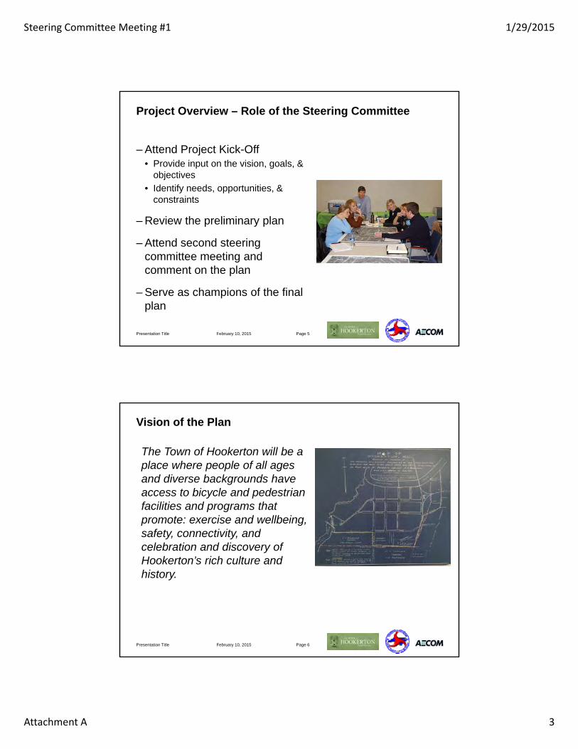
Steering Committee Meeting #1 1/29/2015
Attachment A 3
Project Overview – Role of the Steering Committee
– Attend Project Kick-Off• Provide input on the vision, goals, &
objectives• Identify needs, opportunities, &
constraints
– Review the preliminary plan
– Attend second steering committee meeting and comment on the plan
– Serve as champions of the final plan
February 10, 2015Presentation Title Page 5
Vision of the Plan
The Town of Hookerton will be a place where people of all ages and diverse backgrounds have access to bicycle and pedestrian facilities and programs that promote: exercise and wellbeing, safety, connectivity, and celebration and discovery of Hookerton’s rich culture and history.
February 10, 2015 Page 6Presentation Title

Steering Committee Meeting #1 1/29/2015
Attachment A 4
Goals of the Plan
– Improve safety for pedestrians and cyclists, with an emphasis on already heavily used routes
– Encourage physical activity and well-being
– Provide connections between community origins and destinations and cultural and historic sites through sidewalks and bike paths
– Educate the community as to the benefits of pedestrian activity and applicable rules and regulations
February 10, 2015Presentation Title Page 7
Objectives of the Plan
– Implement policies and programs to improve pedestrian and cyclist safety and educate the community
– Identify and prioritize infrastructure projects such as sidewalks and bike lanes to improve safety and connectivity
– Review and recommend amendments/model ordinances to provide pedestrian and cyclist safety and infrastructure in future developments
– Identify funding sources and partnerships with local businesses, nonprofits, and the Eastern Carolina Rural Planning Organization for implementing the Plan
February 10, 2015Presentation Title Page 8

Steering Committee Meeting #1 1/29/2015
Attachment A 5
Recap of Walking Tour
– Hazards, gaps, deficiencies
– Locations of sidewalks, worn paths, crosswalks, bicycle amenities
February 10, 2015Presentation Title Page 9
Text and Two-Photo Layout
– Level 1 text 20pt Arial• Level 2 bullet 18pt Arial
– Level 1 text 20pt Arial
– Level 1 text 20pt Arial• Level 2 bullet 18pt Arial
– Level 1 text 20pt Arial
February 10, 2015Presentation Title Page 10

Steering Committee Meeting #1 1/29/2015
Attachment A 6
Working Session
– Identify key destinations and points of interest
– Identify existing bicycle and pedestrian infrastructure
– Identify potential projects
February 10, 2015Presentation Title Page 11
Prioritization Criteria
– Connectivity
– Safety
– Implementation
– Community interest Con
nect
ivity
Impl
emen
tatio
n
Com
mun
ity
Inte
rest
Safe
ty
Tota
l Sco
re
Prio
ritiz
atio
n
Project W 2 1 1 3 5 Low
Project X 3 2 3 2 10 High
Project Y 1 3 2 2 8 Med
Project Z 2 3 3 1 9 High
February 10, 2015Presentation Title Page 12

Steering Committee Meeting #1 1/29/2015
Attachment A 7
Next Steps
– Project team will develop the draft plan• Gather additional data• Develop the projects• Coordinate with Town staff,
NCDOT, and the ECRPO• Prioritize the projects
– Review of draft plan
– Revise draft plan
– Finalize the plan
February 10, 2015Presentation Title Page 13
Thank You
January 29, 2015

Town of Hookerton NCDOT Bicycle & Pedestrian Plan
Steering Committee Meeting #1 Minutes
Attachment B ADOPTED Vision, Goals, and Objectives
Vision of the Plan
The Town of Hookerton will be a place where people of all ages and diverse backgrounds have access to bicycle and pedestrian facilities and p+rograms that promote: exercise and wellbeing, safety, connectivity, and celebration and discovery of Hookerton’s rich culture and history.
Goals of the Plan
1. Improve safety for pedestrians and cyclists, with an emphasis on already heavily used routes
2. Encourage physical activity and well-being
3. Provide connections between community origins and destinations and cultural and historic sites through sidewalks and bike paths
4. Educate the community as to the benefits of pedestrian activity and applicable rules and regulations
Objectives of the Plan
1. Implement policies and programs to improve pedestrian and cyclist safety and educate the community
2. Identify and prioritize infrastructure projects such as sidewalks and bike lanes to improve safety and connectivity
3. Review and recommend amendments/model ordinances to provide pedestrian and cyclist safety and infrastructure in future developments
4. Identify funding sources and partnerships with local businesses, nonprofits, and the Eastern Carolina Rural Planning Organization for implementing the Plan

Town of Hookerton NCDOT Bicycle & Pedestrian Plan
Steering Committee Meeting #1 Minutes
Attachment C Walking Tour

Town of Hookerton NCDOT Bicycle & Pedestrian Plan
Steering Committee Meeting #1 Minutes
Attachment D Mapping Exercise

Town of Hookerton NCDOT Bicycle & Pedestrian Plan
Steering Committee Meeting #2 Minutes
Minutes – Steering Committee Draft Plan Review Meeting and Open House April 30, 2015 5:00 PM – 7:30 PM
ATTENDEES
• April Baker,Town Clerk and Steering CommitteeMember
Doris Jones,Commissioner and Steering CommitteeMember
• Lemmie Smith,Sheriff and Steering CommitteeMember
• Sandra Stocks,Steering Committee Member
• Sarah Bassett,Project Consultant
• Todd McAulliffe, Project Consultant
• Kory Wilmot,Project Consultant
MINUTES
The Steering Committee for the Town of Hookerton Bicycle & Pedestrian Plan met on Thursday, April 30, 2015 at Hookerton Recreation Park. Four committee members were present. Project consultants Kory Wilmot, Todd McAulliffe, and Sarah Bassett from AECOM were present. The sign-in sheet, agenda, meeting hand out, and a copy of the slides are included as Attachment A.
Introductions The kick-off meeting began with introductions by the project consultants followed by the committee.
Project Update Mr. Wilmot gave an update on what the status of the project and where we were at in the project planning process, including the next steps for completing the plan after tonight’s meeting.
Draft Plan Mr. Wilmot reviewed the overall outline of the plan with the committee and discussed some of the findings presented in the key sections. He then asked the committee members to provide any comments or ask questions that they may have had about the draft plan.
• Questions were asked about the types of projects proposed for specific areas of town and howthat determination was made. Mr. Wilmot explained that this was based on a combination offactors including existing right-of-way, what the committee had discussed at the previousmeeting, and the traffic conditions. It was also noted that these recommendations were notlocked in, and that a large part of this meeting and the open house was to get feedback on whatwas presented and to determine if projects should be modified.

Town of Hookerton NCDOT Bicycle & Pedestrian Plan
Steering Committee Meeting #2 Minutes
• A comment was made about adding lighting as a project in the area around Greene Street and7th Street.
• Recommendation was made to add a project that would provide mileage signs for designatedwalking routes in the area near Greene Street and 7th Street.
• Recommendation was made to designate safe walk zones in the community.• Regarding community facilities, it was noted that Town Hall now also serves as a DMV.• In addition to the verbal comments, Ms. Baker provided some written comments on the plan.
Prioritization After all of the comments were discussed, Mr. Wilmot then explained the prioritization process for the infrastructure projects and for the policy/program projects. Each committee member was asked to pick their two, top-five projects from both lists. The results from this prioritization will be used to update the plan rankings as listed in the plan. This will help the community and steering committee prioritize which projects to focus on as they begin the implementation process.
Public Open House No members of the public attended the public open house during the period of time reserved for the open house (from 6:30 PM to 7:30 PM). The consultant staff used this additional time to discuss the draft plan and projects with the committee.
The meeting was adjourned at 7:30 pm.

Agenda – Steering Committee Meeting and Public Open House April 30, 2015 5 PM – 7:30 PM
STEERING COMMITTEE MEETING
5:00 PM INTRODUCTIONS
Introductions by the Town Staff, Steering Committee, AECOM Team
5:05PM PROJECT UPDATE
Discuss the current progress made on the Hookerton Bicycle and Pedestrian Plan and the next steps following the Public Open House.
Project Schedule

5:10 PM DRAFT PLAN
Review the draft plan and discuss comments or questions from the Steering Committee
5:45 PM PRIORITIZATION
Complete the Community Interest prioritization exercise with the Steering Committee.
6:00 PM ADJOURN AND PREPARE FOR THE PUBLIC OPEN HOUSE
PUBLIC OPEN HOUSE
6:30 PM INTRODUCTIONS
6:40 PM PRESENTATION OF THE DRAFT PLAN INCLUDING PLANNING PROCESS, PROJECT SCHEDULE, AND OVERVIEW OF PLAN RECOMMENDATIONS
7:00 PM REVIEW OF PROJECT MAPS AND QUESTION/ANSWERS
7:30 PM PUBLIC OPEN HOUSE CONCLUDES


STEERING COMMITTEE POLICY RANKING
Please select your top 5 policies from the Draft Hookerton Bicycle and Pedestrian Plan by placing an X in the green column of the 5 policies of your choosing.
Proposed Policies
POLICY NAME DESCRIPTION Top 5
Watch for Me NC Campaign to reduce crashes through education
NC Crossing Guard Training program for school crossing Officers
Bicycle Helmet Initiative Promote helmet use through supplies and training
Let’s go NC Instruct children K-5 on bike/ped safety and skills
Streetwise Cycling Targets adult motorists of rights/responsibilities of bicyclists
Safety Patrol Program AAA training/equipment for safety patrol programs
Walk Bike NC Programs/initiatives that work with pedestrian infrastructure
Share the Road Posters to inform/encourage driver awareness of pedestrians
Bike/Ped Needs Checklist A bike/ped checklist updated regularly by the community
Pedestrian Safety Campaign Campaign for Police to designate signs for pedestrian safety
Bicycle Rodeos Skills event for bicyclists to develop/practice cycling
Bike/Ped Programs A “Weekend Walkabout” for bringing attention to pedestrians
Youth Competition Competition to educate/engage youth
Bike or Walk Day Designate a day, week, month to walk to destination(s)
Walking Club Community walking club to encourage active lifestyles
Open Street Events Festival to celebrate bike/ped facilities and bring awareness
Adopt a Sidewalk Program Adopt a sidewalk or shared use path

STEERING COMMITTEE PROJECT RANKING
Please choose your top 5 projects from the Draft Hookerton Bicycle and Pedestrian Plan by placing an X in
the green column of the 5 projects of your choosing.
Proposed Linear Bicycle, Pedestrian, and Shared Use Path Facilities
FACILITY NAME FROM TO FACILITY TYPE Top 5
1st Street Bike Lane Main Street Church Street Bicycle Lanes
Hookerton Park Bike Route Church Street Hookerton Park Bicycle Lanes
Main Street Bike Lane William Hooker Drive Town Limits Bicycle Lanes
North William Hooker Bike Lane Main Street Town Limits Bicycle Lanes
1st Street Main Street Church Street Sidewalk
4th Street Contentnea Creek Church Street Sidewalk
Church Street South William Hooker Drive 1st Street Sidewalk
Faith Hope Road West Main Street End of Street Sidewalk
Main Street William Hooker Drive 3rd Street Sidewalk
William Hooker Drive
William Hooker Drive Boat Launch Stephenson Road Sidewalk
Hookerton Park Connector
William Hooker Drive Morris BBQ Road Shared Use Path
(Paved)
Historic Cemeteries Trail
Taylor Heights Street
Taylor Heights Street
Shared Use Path (Unpaved)
Rainbow Run Path 10th Street 4th Street Shared Use Path (Unpaved)

TOWN OF HOOKERTONBICYCLE ANDPEDESTRIAN PLAN
TOWN OF HOOKERTON BICYCLE AND PEDESTRIAN PLAN
The Hookerton Bicycle and Pedestrian Plan (the Plan) is a culmination of a planning process to improve bicycle and pedestrian safety, connectivity, and health and well-being through infrastructure projects and community policies and programs. The purpose of the Plan was to evaluate the existing bicycle and pedestrian conditions within Hookerton and recommend programmatic and infrastructure projects to improve safety, connectivity, and well-being.
Adopt the Hookerton Bicycle and Pedestrian Plan
Establish a Bicycle and Pedestrian Advisory Committee
Form partnerships with local and regional businesses, organizations, schools, and government agencies
Coordinate with NCDOT Division 2 to incorporate projects regionally
Coordinate with ECRPO to include infrastructure projects in regional planning processes
Amend Town Ordinances and Zoning Code
Apply for alternative funding sources for the Plan’s recommended projects and programs
Program local funds for bicycle and pedestrian projects
Key Action Steps
13 Linear Bicycle and Pedestrian Projects
16 Bicycle and Pedestrian “Spot” Improvements
4.5 Miles of Linear Bicycle and Pedestrian Facilities
$1,277,300 of Proposed Improvements
R e c o m m e n d e d P r o j e c t s p r o j e c t s b y t h e n u m b e r s
Bicycle Lanes Bicycle ParkingBicycle Maintenance StationBicycle Route Signs
Sidewalk ImprovementsHigh-Visibility Crosswalks
Shared Use PathsShared Use Bridge
Nor th Caro l ina Depar tment o f Transpor ta t ion | | Apr i l 2015
B
icycle
Maintenance
Bicy
cle Signage
Sidewalks
Ped
estria
n Bridge
Share
d Bicycle Lane
Wide
Paved Shoulder
Hig
h-Vi
sbility
Crosswalk
Ped
estria
n Signage
Bicy
cle Parking
A “standard width” travel lane that both bicycles and motor vehicles share. Shared-lane markings increase a motorist’s awareness of the presence of cyclists, reduce the incidence of wrong-way bicycling
The primary elements of the pedestrian environment and are generally made of concrete or pavers. Sidewalks ideally should have a buffer between the pedestrian and motorist.
Encourages cycling by making it safe and more convenient. Signage makes drivers aware of cyclists and helps to guide bicyclists of designated bike routes.
Designates areas with high pedestrian activity or roadway crossing. Alerts drivers to slow down and increases pedestrian safety.
A self-service kiosk for bicycle maintenance. These facilities may include pumps, work stands, or maintenance tools.
A designated crossing on roadways for pedestrians. They are designed for motorist visibility to increase pedestrian safety.
Allows for secure and convenient parking of bicycles, minimizing parking alongside street signs or lighting. The most common type of bicycle parking are bike racks.
Physically separated from
include bicycle paths, side paths, or trails. They are protected facility because they are not shared with motor vehicles.
A paved portion of the roadway to the right of the travel way designed to serve bicyclists, pedestrians, and others.
Typically used to help extend walks and trails across rivers, roads, or other physical elements. These can be utilitarian or an iconic features of the community.
S
hared
Use Path
North Carol ina Depar tment of Transportat ion | | Apr i l 2015

E Church St
Morris BBQ Rd
S. W
illiam H
ooker Dr
N. W
illiam
Hooker D
r
Hookerton Recreation
Park
E Main St
Conten
tnea C
reek
7th St
¬«123
NC RouteLocal RoadStreamWaterbodyPark Town LimitsGreene County
Town ofHookertonBicycle and Pedestrian Plan
Proposed Bicycle & Pedestrian Network
Proposed NetworkBicycle Spot Improvements
Pedestrian Spot Improvements
Shared Use Path Spot Improvements
Bicycle and Pedestrian Linear Facilities
Bicycle Linear Facilities (only)
Shared Use Path Linear FacilitiesExisting Facilities
Sidewalk
Shared Use Path
0 0.250.125Miles
Atlantic Ocean
SouthCarolina
Virginia
Georgia
Kentucky
Tennessee
April 2015
Hookerton
Hookerton
Cutter Creek Golf Community
¬«123
¬«58
Community FeaturesCommercial
Education
Government
Historic/Cultural
Parks/ Recreation
Place of Worship
Points of Interest
Post Office
Public Safety/Health
N

Town of HookertonNCDOT Bicycle & Pedestrian Plan
Public Open House
April 30, 2015

Purpose of Today’s Public Open House
– Provide an Overview of the Plan
– Review the Vision, Goals, and Objectives
– Highlight the Findings and Recommendations
April 30, 2015 Page 2

Plan Overview
– Hookerton’s first bicycle and pedestrian plan
– Funded by a grant from NCDOT with matching funds from the Town
– Led by a Steering Committee and Project Consultant
– Plan’s Purpose:• Evaluate existing bicycle and pedestrian
conditions• Recommend programmatic and infrastructure
projects to improve Safety, Connectivity, and Well-being.
April 30, 2015 Page 3

Vision
The Town of Hookerton will be a place where people of all ages and diverse backgrounds have access to bicycle and pedestrian facilities and programs that promote: exercise and wellbeing, safety, connectivity, and celebration and
discovery of Hookerton’s rich culture and history.
Page 4
Hookerton Town Motto
“Peace and Quiet when you want it, Great Neighbors
when you don’t.”
Hookerton Town Motto
“Peace and Quiet when you want it, Great Neighbors
when you don’t.”
April 30, 2015

Summary of the Goals and Objectives
1. Bicycle and Pedestrian Safety
2. Bicycle and Pedestrian Network
3. Physical Activity, Health, and Wellbeing
4. Connect Cultural and Historic Sites
5. Bicycle and Pedestrian Education
6. Funding and Partnerships
April 30, 2015 Page 5

Findings
– No existing bicycle infrastructure and limited pedestrian facilities
– Roads are narrow with limited shoulders
– Safety is a concern especially for residents walking along uneven sidewalks
– Residents would like bicycle lanes, sidewalks, and shared use paths to improve safety, connectivity, and health
April 30, 2015 Page 6

Infrastructure Recommendations
– Linear Facilities (13 projects)• Bicycle Lanes• Sidewalks• Shared Use Paths
– Spot Improvements (16 projects)• Marked Crosswalks• Pedestrian Signals• Bicycle Parking• Bicycle Maintenance • Shared Use Pedestrian Bridge
Page 7April 30, 2015

Examples of Wide Paved Shoulders and Bike Lanes
April 18, 2015 Page 8

Examples of Shared Use Path
April 18, 2015 Page 9

Examples of a Pedestrian Bridge and Crosswalk
April 18, 2015 Page 10

Programmatic Recommendations
– Form a Bicycle and Pedestrian Advisory Committee
– Reduce Speed Limits
– Participate in the Watch for Me NC Campaign
– Coordinate with local and regional business, churches, organizations, and other government agencies to promote bicycle and pedestrian planning
Page 11April 30, 2015

Next Steps
– Project team will:• Prioritize the projects based
on your input• Finalize the Plan
– Key Action Steps for implementing the plan are shown to the right
Page 12April 30, 2015
Key Action Steps
1. Adopt the Hookerton Bicycle and Pedestrian Plan
2. Establish a Bicycle and Pedestrian Advisory Committee
3. Form partnerships with local and regional businesses, churches, organizations, and schools,
4. Coordinate with NCDOT Division 2 to incorporate projects on a regional scale
5. Coordinate with ECRPO to include infrastructure projects in the regional planning process
6. Amend Town Ordinances and Zoning
7. Apply for alternative funding sources for the Plan’s projects and programs
8. Program local funds for bicycle and pedestrian projects

Thank You
April Baker, Town of [email protected]
John Vine-Hodge, NCDOT Project [email protected]
Kory Wilmot, AECOM Consultant Project [email protected]
April 30, 2015

Appendix B: State and Federal Policies | Page B-1
Appendix B: State and Federal Policies
Applicable state and federal policies pertaining to bicycle and pedestrian programs and facilities are summarized in Table B-1 below.
Table B-1: State and Federal Policies
POLICY APPLICABILITY TO BICYCLE AND PEDESTRIAN PLANNING
Federal Policies
Americans with Disabilities Act (ADA) (1990)
Ratified in 1990, ADA prohibits discrimination on the basis of disability. Title III pertains to public accommodations including transportation. Federally funded bicycle and pedestrian projects must comply with the Americans with Disabilities Act.
American Association of State Highway and Transportation Officials (AASHTO)
AASHTO publishes design standards for transportation facilities including bicycle and pedestrian projects. These standards are often adopted by state departments of transportation, helping in the design of safe and efficient bicycle and pedestrian facilities.
Manual on Uniform Traffic Control Devices (MUTCD) (2009)
The MUTCD defines the standards used by road managers nationwide to install and maintain traffic control devices on all public streets, highways, bikeways, and private roads open to public travel. The MUTCD is published by the Federal Highway Administration (FHWA) under 23 Code of Federal Regulations (CFR), Part 655, Subpart F.
Moving Ahead for Progress in the 21st Century (MAP-21) (2012)
MAP-21 funds surface transportation programs and creates a streamlined, performance-based, and multimodal program to address the many challenges facing the U.S. transportation system. MAP-21 reorganizes many of the dedicated bicycle and pedestrian funding programs into other functions.
Applicable programs under MAP-21 for bicycle and pedestrian projects include: Transportation Alternatives Program (TAP), , and Surface Transportation Program (STP).
Title VI of the Civil Rights Act of 1964 and Executive Order 12898 (1964, 1998)
Title VI of the Civil Rights Act of 1964 requires that each federal agency ensure that no person is excluded, denied, or discriminated based on race, color, national origin, age, sex, disability.
Executive Order 12898 signed by President Bill Clinton in 1994 requires that each Federal agency shall make achieving environmental justice part of its mission by identifying and addressing, as appropriate, disproportionately high and adverse human health or environmental effects of its programs, policies, and activities on minority populations and low-income populations.

Page B-2 | Appendix B: State and Federal Policies
POLICY APPLICABILITY TO BICYCLE AND PEDESTRIAN PLANNING
United States Department of Transportation Mission Statement (2010)
The DOT policy is to incorporate safe and convenient walking and bicycling facilities into transportation projects. Every transportation agency, including DOT, has the responsibility to improve conditions and opportunities for walking and bicycling and to integrate walking and bicycling into their transportation systems.
Because of the numerous individual and community benefits that walking and bicycling provide — including health, safety, environmental, transportation, and quality of life — transportation agencies are encouraged to go beyond minimum standards to provide safe and convenient facilities for these modes.
State Policies
NCDOT Bicycle Policy
The NCDOT Bicycle Policy states that bicycling is a “bonafide” highway purpose subject to the same rights and responsibility and eligible for the same considerations as other highway purposes. It also designates bicycle facility planning be included in the state thoroughfare and project planning process. http://www.ncdot.gov/bikeped/download/bikeped_laws_Bicycle_Policy.pdf
NCDOT Board of Transportation Resolution for Bicycling and Walking
The resolution states that the North Carolina Board of Transportation strongly reaffirms its commitment to improving conditions for bicycling and walking, and recognizes non-motorized modes of transportation as critical elements of the local, regional, and national transportation system. . It also acknowledges the benefits that bicycling and walking offer: cleaner air, reduced congestion, more livable communities, more efficient use of road space and resources and healthier people. http://www.ncdot.gov/bikeped/download/bikeped_laws_BOT_Mainstreaming_Resolution.pdf
NCDOT Bridge Policy
The NCDOT Bridge Policy states that sidewalks should be included on new bridges with curb and gutter approaches that are not controlled access facilities. Sidewalks may be on one or both sides of the bridge. The sidewalk should be a minimum of 5 to 6 feet wide. https://connect.ncdot.gov/projects/Roadway/RoadwayDesignAdministrativeDocuments/Bridge%20Policy.pdf
NCDOT Complete Streets
Adopted in July 2009, the Complete Streets policy encourages alternative forms of transportation; increases connectivity between neighborhoods, streets, and transit systems; and improves safety for pedestrian, cyclists, and motorists. http://www.completestreetsnc.org/
NCDOT Division of Bicycle and Pedestrian Transportation
The NCDOT Division of Bicycle and Pedestrian Transportation assists communities across the state improve bicycle and pedestrian safety and mobility. The Division provides technical assistance, design guidelines, and resources such as the Watch for Me NC campaign.
NCDOT Greenway Policy
In 1994, NCDOT adopted guidelines to consider greenways and greenway crossings during the highway planning process. This policy was incorporated so that critical

Appendix B: State and Federal Policies | Page B-3
POLICY APPLICABILITY TO BICYCLE AND PEDESTRIAN PLANNING corridors which have been adopted by localities for future greenways will not be severed by highway construction. http://www.ncdot.gov/_templates/download/external.html?pdf=http%3A//www.ncdot.gov/bikeped/download/bikeped_laws_Greenway_Admin_Action.pdf
NCDOT Mission Statement
NCDOT’s mission is: “Connecting people and places safely and efficiently, with accountability and environmental sensitivity to enhance the economy, health and well-being of North Carolina.” Bicycle and pedestrian facilities help to accomplish this mission by improving safety, encouraging physical activity, and providing environmentally friendly alternatives to motorized transportation.
NCDOT Pedestrian Policy Guidelines
The NCDOT Pedestrian Policy states that the Department of Transportation will replace existing sidewalks disturbed as a result of a highway improvement. The Department is authorized to construct new sidewalks adjacent to State highway improvement projects at the request of the municipality provided the municipality agrees to reimburse for the construction cost of the sidewalks. Maintenance of sidewalks will be the responsibility of the municipality. http://www.ncdot.gov/bikeped/download/bikeped_Ped_Policy.pdf
Strategic Mobility Formula
The Strategic Transportation Investments (STI) law signed June 2013, establishes the Strategic Mobility Formula for funding transportation projects in North Carolina. The formula divides bicycle and pedestrian projects into incidental and independent projects. Incidental projects are included in larger transportation projects while independent projects are standalone such as adding a sidewalk to an existing road. Independent projects are capped at 20 projects per M/RPO annually.
Sources: Advocacy Advance, American Association of State Highway and Transportation Officials, Federal Highway Administration, North Carolina Department of Transportation, United States Department of Transportation

Appendix C: Design Guidelines | Page C-1
Appendix C: Design Guidelines
General design guidelines are contained in this appendix according to AASHTO (2004) Guide for the Planning, Design, and Operation of Pedestrian Facilities (Fourth Edition), AASHTO (2012) Guide for the Development of Bicycle Facilities (Fourth Edition), the FHWA Manual on Uniform Traffic Control Devices (MUTCD) 2009 Edition Revisions 1 and 2, and NCDOT typical highway cross sections. NCDOT adheres to these guidelines and the state Complete Streets guidelines in its design of bicycle and pedestrian facilities. The following design guidelines are included in this appendix:
• Sidewalks • Paved Shoulders • Bicycle Lanes • Shared Use Paths • Crosswalks and crossings • Pedestrian signals • Pavement Markings and Signage • Wayfinding

Page C-2 | Appendix C: Design Guidelines
BICYCLE AND PEDESTRIAN
Typical Sections

Appendix C: Design Guidelines | Page C-3
BICYCLE AND PEDESTRIAN
Typical Sections

Page C-4 | Appendix C: Design Guidelines
BICYCLE AND PEDESTRIAN
Typical Sections
Dimensions
Typical Section 2B 2C 2D 2E 3C
Posted Speed 45 mph or
less 25 - 35 mph 25 - 45 mph 25 - 45 mph 25 - 45 mph
Paved Shoulder Width 4 ft. 4 ft. 4 ft. – –
Sidewalk width: – – 5 ft. 5 ft. 5 ft.
Sidewalk buffer width to edge of pavement: – – 24 ft. 6 - 8 ft. 6 - 8 ft.
Bicycle lane width: – – – 5 ft. 5 ft.
Gutter pan width: – – – 2 ft. 2 ft.
Travel lane width: 11 ft. 10 ft. 11 ft. 11 ft. 11 ft.
Travel lanes + turning lane: 2 lanes 2 lanes 2 lanes 2 lanes 2 +1 lanes
Right-of-way minimum: 60 ft. 50 ft. 90 ft. 60 ft. 80 ft.
Curb and Gutter No No No Yes Yes
Sources: NCDOT Typical Highway Cross Sections (2014)

Appendix C: Design Guidelines | Page C-5
SHARED USE PATHS
Typical Section
Dimensions
Shared Use Path width: 10 ft. minimum
Shared Use Path shoulder width: 2 ft. minimum
Source: NCDOT Shared Use Pathways Guidance (2007)

Page C-6 | Appendix C: Design Guidelines
BICYCLE AND PEDESTRIAN
Design Guidelines

Appendix C: Design Guidelines | Page C-7
BICYCLE AND PEDESTRIAN
Design Guidelines

Page C-8 | Appendix C: Design Guidelines
BICYCLE AND PEDESTRIAN
Design Guidelines
*Shared lane markings are only recommended on roads with speed limits of 35 mph or less

Appendix C: Design Guidelines | Page C-9
BICYCLE AND PEDESTRIAN
Design Guidelines
Sources: AASHTO (2012) Guide for the Development of Bicycle Facilities (Fourth Edition). Pages: 3-7, 4-5, 4-15, 4-19, 5-2, 5-23, 5-39.

Page C-10 | Appendix C: Design Guidelines
SHARED USE PATHS
Design Guidelines

Appendix C: Design Guidelines | Page C-11
SHARED USE PATHS
Design Guidelines

Page C-12 | Appendix C: Design Guidelines
SHARED USE PATHS
Design Guidelines
Sources: AASHTO (2012) Guide for the Development of Bicycle Facilities (Fourth Edition). Pages: 5-4, 5-7.

Appendix C: Design Guidelines | Page C-13
SHARED USE PATHS
Design Guidelines
Sidepaths
The following design guidelines from the Pedestrian and Bicycle Information Center should be considered for sidepaths that are built parallel to roadways:
• Shared-use paths are a complement to the roadway network; they are not a substitute for providing access on streets.
• Connections to the regular street network are important, but a high number of crossings at intersections create potential conflicts with turning traffic.
• At intersections with roadways, paths should be signed, marked, and/or designed to discourage or prevent unauthorized motorized access.
• All users should be encouraged to stay right. An exception may be paths along waterways or other features that capture the attention of pedestrians. In these instances, markings and/or signage may be used to encourage pedestrians to stay on the side of the path closest to the attraction to reduce conflicts associated with pedestrians crossing the pathway.
• Since nearly all shared use paths are used by pedestrians, they need to meet the accessibility requirements of the Americans with Disabilities Act (ADA).
• In areas with extremely heavy pathway volume, it may be necessary to segregate pedestrians from wheeled users.
Source: Pedestrian and Bicycle Information Center (2015) Shared-Use Paths/Sidepaths. http://www.pedbikeinfo.org/planning/facilities_ped_paths.cfm

Page C-14 | Appendix C: Design Guidelines
PEDESTRIAN TREATMENTS
Crossings
The following key issues should be considered when designing pedestrian crossings according to AASHTO:
• Assumptions: Assume that pedestrians want and need safe access to all destinations that are accessible to motorists. Additionally, pedestrians will want to have access to destinations not accessible to motorists such as trails and parks.
• Generators and Destinations: Typical pedestrian generators and destinations include residential neighborhoods, schools, parks, shopping areas, and employment centers. All transit stops require that pedestrians be able to cross the street.
• Controlled Intersections: All intersections that have signals, stop signs, or yield signs to facilitate motor vehicle crossing of streets and arterials must also be designed to accommodate pedestrians.
• Uncontrolled Locations: Pedestrians need safe access at many uncontrolled locations, including both intersections and midblock locations.
• Frequency: Pedestrians must be able to cross streets and highways at regular intervals. Unlike motor vehicles, pedestrians cannot be expected to go a quarter mile or more out of their way to take advantage of a controlled intersection.
Source: AASHTO (2004) Guide for the Planning, Design, and Operation of Pedestrian Facilities (Fourth Edition). Pages: 81, 91 and 93.

Appendix C: Design Guidelines | Page C-15
PEDESTRIAN TREATMENTS
Crosswalks
According to the Manual on Uniform Traffic Control Devices, these following guidelines apply to crosswalks:
• Crosswalk lines should not be used indiscriminately. An engineering study should be performed before a marked crosswalk is installed at a location away from a traffic control signal or an approach controlled by a STOP or YIELD sign. The engineering study should consider the number of lanes, the presence of a median, the distance from adjacent signalized intersections, the pedestrian volumes and delays, the average daily traffic (ADT), the posted or statutory speed limit or 85th-percentile speed, the geometry of the location, the possible consolidation of multiple crossing points, the availability of street lighting, and other appropriate factors.
• New marked crosswalks alone, without other measures designed to reduce traffic speeds, shorten crossing distances, enhance driver awareness of the crossing, and/or provide active warning of pedestrian presence, should not be installed across uncontrolled roadways where the speed limit exceeds 40 mph and either:
o A. The roadway has four or more lanes of travel without a raised median or pedestrian refuge island and an ADT of 12,000 vehicles per day or greater; or
o B. The roadway has four or more lanes of travel with a raised median or pedestrian refuge island and an ADT
Source: Manual on Uniform Traffic Control Devices (MUTCD) 2009 Edition Revisions 1 and 2.

Page C-16 | Appendix C: Design Guidelines
PEDESTRIAN TREATMENTS
Curb Extensions and Curb Radii
Curb extensions increase pedestrian visibility and shorten the crossing distance as shown in the diagram below. They should be located in areas where they will not create a safety hazard to pedestrians caused by larger vehicles turning and encoraching onto the curb.
Smaller curb radii may be considered to limit the speed of vehicles and shorten the crossing distances for pedestrians. However, curb radii should be decided on a case-by-case basis, as they also decrease efficiency for vehicles and can increase the chance of a vehicle driving over the curb and hitting the pedestrian.
Source: AASHTO (2004) Guide for the Planning, Design, and Operation of Pedestrian Facilities (Fourth Edition). Pages: 44, 53 and 74.

Appendix C: Design Guidelines | Page C-17
BICYCLE AND PEDESTRIAN SIGNAGE
Bicycle Signage

Page C-18 | Appendix C: Design Guidelines
BICYCLE AND PEDESTRIAN SIGNAGE
Pedestrian Signage – Unsignalized

Appendix C: Design Guidelines | Page C-19
BICYCLE AND PEDESTRIAN SIGNAGE
Pedestrian Signage – Signalized

Page C-20 | Appendix C: Design Guidelines
BICYCLE AND PEDESTRIAN SIGNAGE
Pedestrian Signage – Signalized
Sign Design Guidelines
• Signs should only be installed when they fulfill a need based on an engineering study or engineering judgment.
• In general, signs are often ineffective in modifying driver behavior, and overuse of signs can diminish their effectiveness
• Minimum mounting height for signs where pedestrians are present is 7 feet • As an advance warning device, the pedestrian crossing sign (W11-2) should be installed in advance of
midblock crosswalks or locations where unexpected entries into the roadway by pedestrians might occur
• The school advance warning sign (S1-1) should be used in advance of the first installation of the school speed limit sign assembly and should be installed in advance of locations where school buildings or grounds are adjacent to the highway. It should be supplemented with the Ahead sign (W16-9P).
Pedestrian Signal Design Guidelines
• Symbols for pedestrian signal indications should be at least 6 inches high • Pedestrian signal indications should be conspicuous and recognizable to pedestrians at all distances
from the beginning of the controlled crosswalk to a point 10 feet from the end of the controlled crosswalk, during both day and night.
• For crosswalks where the pedestrian enters the crosswalk more than 100 feet from the pedestrian signal indications, the symbols should be at least 9 inches high
• Pedestrian signal heads should be mounted with the bottom of the signal housing including brackets not less than 7 feet nor more than 10 feet above sidewalk level and shall be positioned and adjusted to provide maximum visibility at the beginning of the controlled crosswalk
• If pedestrian signal heads are mounted on the same support as vehicular signal heads, there shall be a physical separation between them
Source: AASHTO (2004) Guide for the Planning, Design, and Operation of Pedestrian Facilities (Fourth Edition). Pages: 105, 111-114.

Appendix C: Design Guidelines | Page C-21
BICYCLE AND PEDESTRIAN SIGNAGE
Pedestrian Signage – School Areas

Page C-22 | Appendix C: Design Guidelines
BICYCLE AND PEDESTRIAN SIGNAGE
Wayfinding Signage
Sources: Manual on Uniform Traffic Control Devices (MUTCD) 2009 Edition Revisions 1 and 2.

Appendix D: Funding Sources | Page D-1
Appendix D: Funding Sources
Table D-1 below provides a list of funding sources, eligible projects, potential award amounts, and match requirements for bicycle and pedestrian infrastructure projects and programs in Hookerton.
Table D-1: Funding Sources
SOURCE ELIGIBLE PROJECTS FINANCIAL ASPECTS
Federal Funding Sources
Highway Safety Improvement Program (HSIP)
• Bicycle or pedestrian projects on any public road, bike path, or trail
• Typically requires 10 percent match • $2 billion authorized in FY 2013
State and Community Highway Safety Grant Program (Section 402)
• Education, enforcement, and research programs designed to reduce traffic crashes, deaths, injuries, and property damage
• Administered by the Governor’s
Representative for Highway Safety • $235 million authorized in FY 2013
Surface Transportation Program (STP)
• Projects on federal-aid highway • Safety brochure or book • Technical assistance
• Typically requires 20 percent match • $10 billion authorized in FY 2013
Transportation Alternatives Program (TAP)
• Pedestrian and bicycle facilities • Recreational trails • Safe Routes to School projects • Technical assistance • Programmed through the Strategic
Transportation Investments – Strategic Mobility Formula process
• Typically requires 20 percent match • Can be received directly by local
governments • $808 million authorized in FY 2013
Urbanized Area Formula Program (UZA)
• Public transportation projects • In urbanized areas of more than 200,000
at least 1 percent of funds must be used for bicycle and pedestrian facilities
• Typically requires 20 percent match • $2 billion authorized in FY 2013
State Funding Sources
Clean Water Management Trust Fund (CWMTF)
• Projects that enhance or restore degraded waters, acquire land with ecological, cultural, and historic significance
• Greenway/shared use paths are eligible
• Requires matching funds • Annual grant cycle

Page D-2 | Appendix D: Funding Sources
SOURCE ELIGIBLE PROJECTS FINANCIAL ASPECTS
Land and Water Conservation Fund (LWCF)
• Land acquisition and/or development projects for public outdoor recreation and/or to protect outstanding natural or scenic resources
• Projects must be on a single site
• Requires 50 percent match • Administered by the Division of
Parks and Recreation
Parks and Recreation Trust Fund (PARTF)
• Acquisition and/or development of park and recreational projects
• Requires 50 percent match • Administered by the Division of
Parks and Recreation
Powell Bill
• “Maintaining, repairing, constructing, reconstructing or widening of any street or public thoroughfare within the municipal limits or for planning, construction, and maintenance of bikeways, greenways or sidewalks.”
• Annual allocation from the State to qualifying municipalities
• $13,491 awarded to Hookerton in FY 2014
Recreational Trails Program
• Trail construction • Trail facilities and amenities • Programs that promote safety and
environmental protection as they relate to recreational trail projects
• Maximum grant award $200,000 • Requires 25 percent match • Federal funds managed by the
Division of Parks and Recreation
Strategic Mobility Formula
• Limited funding for bicycle and pedestrian projects that are at least $100,000 and included in a locally adopted plan
• Programmed through the Strategic Transportation Investments – Strategic Mobility Formula process
• State funds may not be used for a local match (except for Powell Bill funds)
• MPOs/RPOs may submit up to 20 bicycle/pedestrian projects
• Right-of-way is not an eligible expense
Safe Routes to School (SRTS)
• Infrastructure projects within 2 miles of a K-8 school
• Project must be within the public right-of-way
• No match required • Currently funding with leftover
SRTS funds, once expended TAP funds will be used and programmed through the Strategic Transportation Investments – Strategic Mobility Formula process
Local Funding Sources
Capital Reserve Fund • May be used to fund bicycle and
pedestrian infrastructure projects
• The Town Commissioners would establish the fund through an ordinance
• May be financed through town budget allocations, grants, and donations

Appendix D: Funding Sources | Page D-3
SOURCE ELIGIBLE PROJECTS FINANCIAL ASPECTS
Community Crowdfunding
• Unrestricted source of funds, would apply to bicycle and pedestrian linear facilities and spot improvements
• Town residents make monetary contributions through online platforms such as Citizenvestor
• Town would pay a nominal fee
Fees
• The fee ordinance would establish which projects are eligible
• Shared use path projects may be eligible for funds generated by stormwater fees as these projects could mitigate the effects of runoff
• Would require adoption by the Town Commissioners
• Fee types may include stormwater fees assessed per area of impervious surface or streetscape fees assessed per length of street frontage
General Obligation Bonds
• May be used to fund bicycle and pedestrian infrastructure projects
• Would require adoption by the Town Commissioners
• Would require approval by town residents
Special Tax District
• May be levied by the municipality to raise funds to provide services or fund projects such as bicycle and pedestrian infrastructure projects
• Would require adoption by the Town Commissioners
Tax Increment Financing
• Pedestrian and bicycle infrastructure improvements, land acquisition, utilities, and other improvements
• Increased property values resulting from the constructed facility are used to pay the debt borrowed to build the facility
Nonprofit Funding Sources
Blue Cross Blue Shield of North Carolina Foundation
• Focused on health-related projects. Bicycle and pedestrian projects may be eligible due to their associated benefits of increased exercise and recreation
• Check the Foundation’s website for current grants: http://www.bcbsncfoundation.org
Greene County Community Foundation
• Community foundation affiliated with the North Carolina Community Foundation that supports local grantmaking. Bicycle and pedestrian projects may be eligible for grants through the foundation
• Visit the Greene County Community Foundation’s webpage for more information: http://www.nccommunityfoundation.org/greene
Kate B. Reynolds Charitable Trust
• Focused on improving health and wellness (75% of funding is directed towards health-related projects)
• Capital projects are eligible
• Maximum grant award for capital projects is $150,000
• Applications submitted in February and August: http://www.kbr.org/

Page D-4 | Appendix D: Funding Sources
SOURCE ELIGIBLE PROJECTS FINANCIAL ASPECTS
Robert Wood Johnson Foundation
• National organization, focused on: gathering and monitoring of health-related statistics, public education, technical assistance, and evaluations
• Capital projects are not eligible
• Grants are awarded through calls for proposals: http://www.rwjf.org/
Data sources: Advocacy Advance, MAP-21 Find It, Fund It!; Blue Cross Blue Shield of North Carolina; Kate B. Reynolds Charitable Trust; NCDOT, Strategic Transportation Investments; NC Clean Water Management Trust Fund; NC Division of Parks and Recreation; Robert Wood Johnson Foundation

Appendix E: Cost Estimates | Page E-1
Appendix E: Cost Estimates This appendix contains the cost figures used in project estimates. The majority of the cost figures are from the Pedestrian and Bicycle Information Center’s Costs for Pedestrian and Bicyclist Infrastructure Improvements (“PBIC Report”). The cost estimate for striping bicycle lanes on existing pavement is from NCDOT average cost figures for road striping and a range provided by PBIC. The Shared Use Bridge cost estimate is from Gator Bridge (http://www.gatorbridge.com/).
Table E-1: Cost Estimate Figures for Linear Facilities
ITEM ESTIMATED COST
(per mile)* DESCRIPTION
Sidewalk (2 Sides / 1 Side) $285,000 / $142,500
Sidewalk is concrete and 5 feet wide, 4 inches thick. This factor was scaled proportionally
for a 10 foot wide sidewalk along Main Street.
Bicycle Lane $15,000
Bicycle lane is 4-5 feet wide and striped on existing pavement on both sides of the road.
This cost estimate is based on average NCDOT cost figures for road striping and a
range provided by PBIC
Wide Paved Shoulder $70,000
A specific cost figure for wide paved shoulders was not available, so the cost
estimate for five-foot bicycle lanes on new pavement from the PBIC Report was
decreased proportionally for a 4 foot wide paved shoulder.
Shared Lane $7,000
PBIC Report provided a cost figure of $160 per shared lane marking. According to the MUTCD, shared lane markings should be
spaced no more than 250 feet apart. Based on this spacing, 43 markings would be required
per mile for both sides of the road.
Shared Use Path (Paved) $330,000
PBIC Report provided a cost figure of $261,000/mile for an 8 foot wide paved path. This was factor was scaled proportionally for
a 10 foot wide path.
Shared Use Path (Unpaved) $85,000 Unpaved shared use path is 8 feet wide *Costs over $10,000 were rounded to the nearest $5,000. Costs under $10,000 were rounded to the nearest $1,000.

Page E-2 | Appendix E: Cost Estimates
Table E-2: Cost Estimate Figures for Spot Improvements
ITEM ESTIMATED COST
(per item)* DESCRIPTION
Bicycle Maintenance Station $1,000
Provides tools to make bicycle adjustments and a pump to inflate tires, estimated cost
based on that a bicycle rack is $500 with an additional $500 for tools and pump
Bicycle Parking $500 A traditional inverted U-shaped rack for
parking and securing bicycles
Bicycle Lane Sign $200 Designates the roadway as a bicycle route
Bollard $700
Bollards are posts embedded in the ground at entrances to shared use paths to separate pedestrians and cyclists from motorized
traffic.
High Visibility Crosswalk $3,000
Provides more visibility than regular striped crosswalks and lasts longer. Price given is per
linear segment.
Shared Use Bridge $300,000 200 foot span, 10 feet wide
Gator Bridge estimates $150/square foot
Street Lighting $4,000 Traditional overhead street light
Wayfinding Sign $500 Informational sign that may include text and
maps *Costs rounded to the nearest hundred or thousand.

Sedalia
Hookerton
Saluda