section 9 — beginning to think globally - wikispaces · web viewits name comes from the arabic...
TRANSCRIPT

Section 1 — Introduction
A camel caravan carries trade goods across the Sahara. Owen Franken/Corbis
The Saharan region [region: an area defined by one or more natural or cultural characteristics that set it apart from other areas] is filled with the unexpected. Just ask someone who has survived the Dakar Rally. In this rally, cars, trucks, and motorcycles race against each other. They also race against the wind, sand, and heat of this desert [desert: a geographic region with too little rainfall to support much plant life; also a vegetation zone]. With few roads, drivers speed over shifting dunes, rocky plains, and dry grasslands. They cross dry riverbeds that have not seen water in years. They struggle through sandstorms and scorching heat. If driving across the Sahara is this hard, think how much harder it must be to live there.
The Sahara is one of the harshest environments on Earth. Through the years, however, people have adapted to living in this hot, arid [arid: dry or lacking rainfall; also a climate or climate zone that is hot and dry all year with very little rain] region. Most people live near a desert oasis [oasis: an isolated spot in a desert where water is found]. An oasis is an isolated spot where water is found in a desert.
The Sahel is a semiarid grassland along the Sahara’s southern edge. Its environment is not quite as harsh as the Sahara. But the Sahel often suffers from drought [drought: an unusually long period in which little or no rain falls], or long periods with very little or no rain. This decrease in rainfall has made life there even more challenging.
In this chapter, you will read about the physical features [physical feature: any natural characteristic of Earth’s surface, such as landforms and bodies of water] of the Sahara and the Sahel. You will find out how the environments of these regions have been shaped by changes in climate [climate: the pattern of weather over a long period of time]. You will also learn how people in the past have adapted—and still are adapting—to these arid lands.

Section 2 — The Geographic Setting
Shrinking Lake ChadLake Chad is a large, shallow lake in the Sahel. The lake shrinks or grows depending on the amount of rainfall. But its overall size is slowly shrinking.
The Sahara stretches across most of North Africa. It covers about 3.5 million square miles. This is an area roughly equal to that of the continental United States. This huge desert is bordered on the east by the Red Sea and on the west by the Atlantic Ocean. To the north, it begins at the Atlas Mountains. From there it sweeps south for more than 1,000 miles. Then the Sahara merges with the semiarid Sahel. Together the Sahara and Sahel cover all or parts of 15 African countries.

The World’s Largest Desert The Sahara is the largest desert in the world. Its name comes from the Arabic word sahra, which means “desert.” Its climate is very hot and very dry. The world’s highest known daytime temperature, 136°F, was recorded there in 1922. Average rainfall is less than five inches a year.
The Sahara has not always been so dry. Many thousands of years ago, the region had a much wetter climate. Rivers and lakes were filled with fish. Elephants and other animals roamed through grasslands and forests. People settled in the region and lived by hunting and fishing.
About 6,000 years ago, the climate of North Africa changed. Year by year, less rain fell. In time, the Saharan region began to turn into a desert. Ever since then, the desert has slowly been expanding.
Trade winds [trade winds: steady winds in tropical latitudes that blow toward the equator from both the north and south] blowing across North Africa help to keep the region dry. These winds begin in northern latitudes and blow south toward the equator. As trade winds pass over the Sahara, they pick up any moisture on the ground below. So little moisture is left that few clouds ever form over the Sahara. With no clouds to provide shade, the sun beats down on the land, making it even drier.
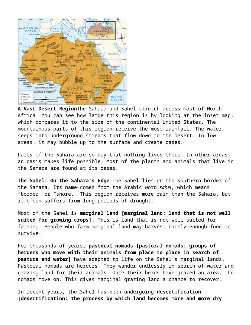
A Vast Desert RegionThe Sahara and Sahel stretch across most of North Africa. You can see how large this region is by looking at the inset map, which compares it to the size of the continental United States. The mountainous parts of this region receive the most rainfall. The water seeps into underground streams that flow down to the desert. In low areas, it may bubble up to the surface and create oases.
Parts of the Sahara are so dry that nothing lives there. In other areas, an oasis makes life possible. Most of the plants and animals that live in the Sahara are found at its oases.
The Sahel: On the Sahara’s Edge The Sahel lies on the southern border of the Sahara. Its name comes from the Arabic word sahel, which means “border” or “shore.” This region receives more rain than the Sahara, but it often suffers from long periods of drought.
Most of the Sahel is marginal land [marginal land: land that is not well suited for growing crops]. This is land that is not well suited for farming. People who farm marginal land may harvest barely enough food to survive.
For thousands of years, pastoral nomads [pastoral nomads: groups of herders who move with their animals from place to place in search of pasture and water] have adapted to life on the Sahel’s marginal lands. Pastoral nomads are herders. They wander endlessly in search of water and grazing land for their animals. Once their herds have grazed an area, the nomads move on. This gives marginal grazing land a chance to recover.
In recent years, the Sahel has been undergoing desertification [desertification: the process by which land becomes more and more dry until it turns into desert. This may be caused by climate change, human activities, or both.]. This is a process in which an area becomes increasingly dry. In this chapter, you will find out why parts of the Sahel are turning into desert and what that means for the people who live there.
Section 3 — The Desert Environment
The Sahara’s Sea of SandErgs, or vast expanses of sand, cover about 13 percent of the Sahara’s land area. Sand dunes move like slowbreaking waves through these “seas of sand.” Little grows on the dunes, and in some places the sand is so soft that camels sink halfway to their knees in it. SuperStock
A line of 500 camels stretches for a mile across the desert. This camel caravan is going to pick up blocks of salt from a distant mine. Its 400-mile round trip will take 30 days. Along the way, the caravan will pass camel bones and abandoned trucks. Travel is not easy in the Sahara.
The Desert Landscape: More Than Just Sand Many people picture the Sahara as a sea of burning sand. But its landscape [landscape: a large area with a particular kind of scenery, such as a desert landscape] is far more diverse. In just one afternoon, a traveler in the Sahara saw “pink and yellow dunes, blue craggy cliffs,

black volcanic rubble... an eroded gulch, two dry rivers, a cone, a canyon, [and] many badlands [barren hills].”
The Sahara has three main types of landforms [landform: any natural feature of Earth’s surface that has a distinct shape. Landforms include major features such as continents, plains, plateaus, and mountain ranges. They also include minor features such as hills, valleys, canyons, and dunes.]: ergs, regs, and hammadas. Ergs [erg: a great sea of sand with tall sand dunes in the Sahara] are great seas of sand with tall sand dunes. These dunes can rise over 400 feet. Most dunes are slowly blown across the desert by the wind. Regs [reg: a gravel-covered desert plain] are gravel-covered plains. Hammadas [hammada: a high, rock-covered flatland in the Sahara] are high, rock-covered flatlands. Some hammadas are so tall that maps show them as mountains.
Only two rivers flow through the Sahara: the Nile and the Niger. The water in both rivers comes from mountains outside the desert. There are also dry riverbeds called wadis [wadi: the usually dry bed of a river or stream in a desert or semiarid area] that can turn into raging rivers after a rain. Then they quickly dry up again.
The Harsh Desert Climate Temperatures vary greatly between day and night. Daytime temperatures often soar above 100°F. At night, temperatures may drop to below freezing. According to an old saying, “Nighttime is the winter of the desert.”
Sandstorms can begin when strong winds pick up dark clouds of dust and sand from the desert floor. A severe sandstorm can reduce visibility to almost nothing. It also gets sand into everything.
Rain is unpredictable in the desert. During a desert storm, it may rain three inches in one spot, while nearby no rain falls. When rain does come, it may quickly fill the wadis. These flash floods can carry away rocks, people, and even trucks.
Plants adapt to these conditions in several ways. Some sprout quickly after a rain and then set seed and die. The seeds then lie in wait—sometimes for years—for the next rain. Other plants send roots deep into the ground to find water. Deep roots also hold these plants in place during sandstorms and flash floods. Most desert trees and shrubs have small, waxy leaves that lose little moisture. During long periods of drought, they may shed their leaves.
Section 4 — Adaptations to Life in the Desert

Nomads Tend Their HerdsTuareg nomads move their herds to find water or better pasture. The Tuareg depend upon their animals for milk. They trade milk, cheese, and some meat for the goods they cannot make or grow themselves.
Many desert nomads belong to a group known as the Tuareg. The Tuareg live in six countries in the southern Sahara and Sahel.
The Wandering Tuareg The nomadic Tuareg raise camels, goats, cattle, or sheep. When the pasture in one area is used up, they move their animals to a fresh grazing area.
The Tuareg are known as the “Blue Men of the Desert” because of their flowing blue robes. Their long, loose clothing protects them from the burning sun. Men also wear blue cloth wrapped around their heads and across their faces. Some Tuareg men never remove this face cover, even in front of close family members.
Tuareg nomads live in family groups of fewer than 100 people. These groups are always ready to move. It takes a Tuareg family only two hours to take down the tents that are their homes and pack up their belongings. Everything a family owns fits on one camel or two donkeys. When they reach an oasis, the nomads trade meat, cheese, or milk for grain, vegetables, fruit, and water.
Tuareg traders lead camel caravans across the desert. Camels are well suited for desert travel. A camel can walk long distances over sandy ground with little food or water. It is easy to get lost in the Sahara, but the Tuareg know the local landmarks. They also know how to use the stars to find their way. This allows them to travel at night, when the air is cooler.
Trucks Replace CamelsTrucks are gradually replacing camels in the Sahara. There are not many roads, though, so trucks are built to deal with the rough and sandy desert. The owner of this truck has to clear away the sand that has piled up overnight before beginning the day’s work. Pascal Meunier-Cosmos/Aurora
Technology Makes Life Easier Modern technology [technology: the creation and use of tools to meet practical needs; also refers to the tools themselves] has improved life for many desert dwellers. Pastoral nomads have found many uses for lightweight plastic and metal containers. Some desert traders can afford satellite phones to keep in touch with their customers.
Technology has created new oases. Drilling machines cut through rock to find underground water. Electric pumps then draw this water to the surface.
Trucks and planes have improved desert transportation. Trucks are replacing camels for hauling heavy loads. Small planes are also used to fly people and goods between oases.

Section 5 — The Oasis Environment
Desert OasesAn oasis is a place in the desert where water is found. Some oases are natural. Others have been created by people. However they came to be, all oases are precious. They allow life to exist in one of the world’s harshest environments.
The Sahara holds many surprises. In a hidden canyon oasis, crocodiles feed on fish and on animals that come to drink. At a larger oasis, thousands of date palms shade fruit trees. Wild gazelles graze nearby. In this arid land, where there is water there is life.
Islands of Water Surrounded by Desert For travelers crossing the Sahara, no sight is more welcome than a distant palm tree. The palm is a sign that an oasis is nearby. Each oasis is an island of fresh water in a sea of dry sand and rock.
Some oases are natural. Many are created by springs that bubble up to the surface from streams beneath the ground. Other oases appear in low spots. Here the land dips down to meet an underground stream.
Humans create some oases. In the past, people made oases by digging wells by hand. As you read, drilling machines are now being used to dig deep into the ground to locate hidden water.
Large and Small Centers of Life The Sahara has about 90 large oases. Here there is enough water to support a village and small farms. There are many small oases as well. Some may support only one or two families.
Many kinds of plants and animals are found at a desert oasis. Acacia and baobab trees mix with smaller shrubs. Gazelles and other animals drink in the pools. Butterflies, crickets, and other insects flit through oasis gardens.
Date palms are by far the most important and common oasis plant. Every part of this tree is useful. Its fruit, the date, is eaten fresh or dried. Its trunk and leaves are used as building materials. Fiber from its bark is made into rope. Date pits, or seeds, are burned as fuel or fed to animals. A visitor to the Sahara once wrote,
Those magnificent palm groves are the blood and bone of the desert; life in the Sahara would be unthinkable without them.... The size of an oasis is reckoned by the number of trees it contains, not by the number of square miles it covers.
Section 6 — Adaptations to Life in the Oases

Palms Produce a Cash CropDate palms produce the desert’s most valuable cash crop. Other fruit trees are often planted in the shade of date palms.
Most oasis settlements are small, with fewer than 2,000 people. The largest ones may have thousands of date palms. But in an oasis with little water, several families may share a single date palm.
The Traditional Ways of Oasis Settlers Trading and farming are the major economic activities [economic activities: any action that relates to the making, buying, and selling of goods and services] at an oasis. While most people are subsistence farmers, others grow cash crops [cash crop: a crop that is grown to be sold rather than to be consumed by the farmers and their families] like dates, wheat, barley, and vegetables. Farmers trade their produce for goods brought in by camel, truck, and plane. Visiting nomads trade their meat, milk, and cheese for water and food. Caravans and trucks stop to trade and to fill their containers with water.
Most homes in an oasis town are made of mud bricks. They have few windows in order to keep out the heat. Little work is done during the hottest part of the day. In the cool of the evening, people gather to discuss the day’s news.
An oasis farmer is always fighting the desert. Blowing sand and creeping dunes will quickly cover crops unless they are protected by windbreaks [windbreak: a wall or hedge that breaks the force of the wind]. A windbreak is a wall or hedge that breaks the force of the wind. It can also stop sand from piling up on a farm field.

Water Problems Limit the Growth of Oasis Towns Oasis settlements come in many sizes. Most are small villages. A few are growing into towns and cities. As an oasis settlement grows, its water problems grow as well.
People move to an oasis for many reasons. Some may be looking for jobs on date farms or in date-processing plants. These factories get dates ready for export. Nomads sometimes settle at an oasis when they can no longer find pasture for their animals. Refugees from drought or war may move to an oasis in search of water, food, and safety.
Growing oasis towns face two kinds of water problems. The first problem is how to get water to people as the town expands. New housing areas and camps set up to shelter refugees often lack wells or piped water. If people cannot walk to water sources, water may have to be brought to them by truck.
The second problem is water shortages. In some oases, palm groves have been expanded into the surrounding desert. The new trees are kept alive with water pumped out of the ground. If too much water is pumped out, the underground streams that create an oasis could run dry.
Section 7 — The Sahel Environment
Cattle in the SahelOvergrazing by cattle is a major cause of desertification in the Sahel. When too many cattle graze in an area, they destroy its cover of plants. Without this protective cover, the soil is eroded by wind or water.
A television ad in southern Niger begins by panning across a desert landscape. The next scene follows camels, donkeys, and trucks carrying firewood into towns. A quick cut shows a coal-mining operation. The ad ends by showing a woman cooking with coal in her smoke-free kitchen. The ad is intended to persuade people in Niger to switch from wood to coal for cooking. Such a switch could help to preserve Niger’s trees. It might also prevent desertification.
The southern area of Niger is part of the Sahel. Other areas include Gambia and parts of Senegal, Mauritania, Mali, Burkina Faso, Nigeria, Chad, and Sudan. In good years, just enough rain falls in the Sahel to grow crops. During years of drought, life in the region becomes very difficult.
A Landscape Threatened by Drought and Desertification The Sahel begins at the Sahara’s edge. The land here is marginal for farming. The soil is not fertile, and water is scarce most of the year. The natural vegetation [vegetation: all the plants and trees in an area] is a mix of grasslands, acacia trees, baobab trees, and small bushes. Farther south, where rain is more plentiful, vegetation is more varied.

Drought is a fact of life in the Sahel. One severe drought began in 1968. Little rain fell for the next six years. Since then, there has been some rain, but not enough for the land to recover fully.
As the drought continued, desertification began. In areas with little rain, few plants grew. Without plants to hold the dry soil in place, desert winds picked it up and carried it away. When this happened, marginal lands turned into desert. Experts aren’t sure whether this desertification is a short-term problem or whether these marginal lands are lost forever to an expanding Sahara.
Section 8 — Adaptations to Life in the Sahel
Sahel SandstormSandstorms like this one in Mali are made worse by desertification. Winds pick up loose soil from worn-out land and blow it away. Dust from the Sahel is sometimes carried across the Atlantic Ocean. When this dust reaches Florida, it creates reddish sunsets.
Most people in the Sahel are farmers or herders. In the past, they adapted to the challenge of farming and herding on marginal land in many ways.
One adaptation [adaptation: a change in a way of life to suit new conditions] was to plant crops like millet and sorghum. These are grains that will grow in dry places. Another was to use a farming system known as shifting agriculture [shifting agriculture: the practice of clearing one area for farming for a few years and then moving on to another area when the first has lost its fertility]. A farmer cleared a field and planted it with crops for a year or two. Then the farmer moved on to a new field. Herders used a similar system to feed their animals. They moved their herds from one grazing area to another throughout the year. Both systems gave worn-out fields a chance to rest.
Human Causes of Desertification Changing ways of life in the Sahel may be contributing to desertification. Some farmers, for example, have begun to raise cash crops, like peanuts. These cash crops often wear out the soil faster than traditional crops. Once the soil is worn out, it may blow away before it can recover its fertility.

Similarly, some nomads have increased the size of their herds so that they have animals to sell for cash. The result is too many animals on limited grazing land. Loss of vegetation from overgrazing may also contribute to desertification.
Yet another problem is deforestation [deforestation: removing or clearing away the trees from a forest. Deforestation is often done to clear land for farming or ranching.]. Most people in the Sahel use wood as their fuel for cooking. In their search for firewood, they cut down trees. With the trees gone, soil erosion [erosion: the gradual wearing away of Earth’s surface by the action of wind, water, ice, and gravity] increases. That is why the government of Niger is promoting coal as a cooking fuel. “I think that with coal, our sparse forests could be saved,” says a forestry expert in Niger.
Cooking with coal is only one change people are making to fight desertification. Farmers are testing new farming methods that save water and slow soil erosion. Many are working to keep desert sand from burying their fields by building windbreaks of trees and brush.
No one can say how successful this war against the desert will be. But for the people of the Sahel, it is a fight they cannot afford to lose.
Section 9 — Beginning to Think Globally
In this chapter, you learned how people have adapted to living in the Sahara and the Sahel. Pastoral nomads survive by staying on the move. Farmers adapt by settling around oases that serve as farming and trading centers in this arid land. You found out how people have learned to raise crops and animals on the marginal lands of the Sahel. And you have seen how drought and desertification have affected this region.
The Sahel is not the only area in the world threatened by desertification. About a third of Earth’s land is arid or semiarid. And some of these desert regions are expanding. In China, the capital city of Beijing is sometimes blasted by sandstorms. The blowing sand comes from parts of China that are undergoing desertification. Think about this as you look at the world map of arid regions in the next section.
Section 10 — Global Connections
This map shows the world’s deserts and areas threatened by desertification. The diagram illustrates one set of human activities that may lead to desertification. Other factors, such as years of drought, may also play a part.

Are the world’s deserts growing or shrinking? Many areas of marginal land are being threatened by desertification. These places could, in time, become new deserts. Climate change is a factor in this process. In some areas, droughts may speed desertification. In other areas, unusually wet weather may help to slow it down.
What human activities contribute to desertification? The ways people use marginal lands may lead to desertification. Poor farming methods can wear out thin soil. Overgrazing can strip areas of their protective plant cover. Nonnative plants can crowd out native ones better suited to a dry climate. Deforestation can leave marginal lands open to erosion. All of these factors can contribute to the spread of deserts in arid regions.
A Problem with Many CausesAs this diagram shows, desertification is a problem with many causes. Long periods of drought can kill off the vegetation that holds soil in place. Farming and grazing on marginal lands can also leave soil without a protective cover of plants. Without such a cover, soil is easily eroded by wind and rain. The result is an arid wasteland of sand and rock in which little will grow.
How might people adapt to living in areas threatened by desertification? People deal with desertification in many ways. Villagers in China are learning new methods of farming. Their goal is to reduce soil erosion. Australia has developed new programs to prevent wildfires. These programs are designed to keep fire from destroying forests and grasslands. Many developing countries, however, cannot afford such projects. They look to other countries and the United Nations for help in keeping their deserts from spreading.