section 78 land at hawthorns, bells piece, farnham, …
TRANSCRIPT
Ministry of Housing, Communities & Local Government Jean Nowak, Decision Officer Planning Casework Unit 3rd Floor Fry Building 2 Marsham Street London SW1P 4DF
Tel: 0303 444 1626 Email: [email protected]
Liz Alexander Bell Cornwell LLP Unit 2 Meridian Office Park Osborn Way Hook Hampshire RG27 9HY
Our ref: APP/R3650/W/18/3211033 Your ref: 7515
14 May 2020
Dear Madam TOWN AND COUNTRY PLANNING ACT 1990 – SECTION 78 APPEAL MADE BY STAX DEVELOPMENTS LTD LAND AT HAWTHORNS, BELLS PIECE, FARNHAM, SURREY, GU9 9RL APPLICATION REF: WA/2017/2352
1. I am directed by the Secretary of State to say that consideration has been given to the report of Graham Chamberlain BA (Hons) MSc MRTPI, who held a hearing on 25-26 June 2019 into your client’s appeal against the decision of Waverley Borough Council to refuse your client’s application for planning permission for: demolition of existing house and buildings; creation of new access off Hale Road; development of up to 65 mixed dwellings to include 40% affordable housing, creation of open space to act as SANG extension to Farnham Park (including small public car park); associated landscape and infrastructure, in accordance with application ref: WA/2017/2352 dated 11 December 2017.
2. On 15 August 2019, this appeal was recovered for the Secretary of State's determination, in pursuance of section 79 of, and paragraph 3 of Schedule 6 to, the Town and Country Planning Act 1990.
Inspector’s recommendation and summary of the decision
3. The Inspector recommended that the appeal be allowed, and planning permission granted subject to conditions. For the reasons given below, the Secretary of State disagrees with the Inspector’s recommendation and has decided to dismiss the appeal and refuse planning permission. A copy of the Inspector’s report (IR), is enclosed, along with his Addendum Report which was provided at the Secretary of State’s request to assist him in his consideration of the environmental issues in this case, particularly with regard to any impact on the Thames Basin Heaths Special Protection Area (SPA). All references to paragraph numbers, unless otherwise stated, are to the main report dated 15 August 2019 (IR) or to the undated Addendum Report (AR).
2
Matters arising since the close of the inquiry
4. On 14 October 2019, the Secretary of State wrote to the main parties to afford them an opportunity to comment on:
(i) Waverley BC’s “Five Year Housing Land Supply Position Statement” (FYHLSPS), published July 2019, which updated the housing land supply figures presented at the Inquiry, and;
(ii) documents submitted for the hearing on the modifications to the revised Farnham Neighbourhood Plan (rFNP), which was held on 1 October 2019.
The representations received were then circulated to the main parties on 28 October 2019.
5. A further letter dated 13 March 2020 was received from the Council informing the Secretary of State that the rFNP had been approved by referendum on 12 March 2020, and copies of that letter can similarly be obtained. This plan was formally made by Waverley Borough Council on 3 April 2020. The Secretary of State considers that this is relevant to this appeal as the appeal site is in Farnham.
6. The 2019 Housing Delivery Test measurements were published on 13 February 2020. Waverley BC’s score changed from 79% (2018 measurement) to 85% (2019 measurement). In line with Paragraph 73 of the Framework, Waverley BC are no longer required to add a 20% buffer to their deliverable supply of housing sites and must now add a 5% buffer instead. The Secretary of State considers that this is relevant to this appeal, as it affects the ability of Waverley BC to demonstrate a five year supply of housing land.
7. Through representations from the appellant on 19 November 2019 (appeal (i), Windacres Farm) and 5 March 2020 (appeal (ii), Loxwood Road), the Secretary of State has been made aware of two subsequent appeal decisions issued by the Planning Inspectorate against the refusal of planning permission by Waverley Borough Council, those being for:
(i) Land at Windacres Farm, South of Church Street and Hermongers Lane, Rudgwick, Surrey, RH12 3EG – ref APP/R3650/W/19/3230164, dated 15 November 2019 (the Windacres Farm appeal), and;
(ii) Land East of Loxwood Road, Alfold, Surrey – ref APP/R3650/W/19/3237359, dated 2 March 2020 (the Loxwood Road appeal)
The Secretary of State considers that these appeals are relevant to the determination of this appeal as they provide further evidence on the ability of Waverley BC to demonstrate a five year supply of housing land. Any references in this Decision Letter to paragraphs in the Windacres Farm appeal decision letter are preceded with WINDDL, and any references to the paragraphs in the Loxwood Road appeal decision letter are preceded with LOXDL.
8. A representation from Waverley BC concerning their view on the Windacres Farm appeal, and their housing land supply position was received on 3 December 2019. Another representation was received from Waverly BC on 2 March 2020, concerning their housing land supply position in light of the 2019 Housing Delivery Test measurement.

3
9. Ad hoc representations were received from parties on the matters listed between paragraphs 5 and 8 of this Decision Letter between October 2019 and March 2020. Parties were then contacted on 23 April 2020 with a further opportunity to provide representations on these matters, with those representations received circulated back to the main parties on 4 May 2020.
10. Through a representation received on 1 May 2020, the Secretary of State was made aware of a further appeal decision issued by the Planning Inspectorate against the refusal of planning permission against Wokingham Borough Council, for Land north of Nine Mile Ride, Finchampstead, Berkshire – ref APP/X0360/W/19/3238048, dated 9 April 2020 (the Nine Mile Ride appeal). In this case the appellant considered this to be relevant to the determination of this appeal as it addresses the impact of the COVID-19 pandemic that is currently ongoing.
11. The material concerning housing land supply are further addressed between paragraphs 17-24 of this Decision Letter, and the material concerning the Farnham Neighbourhood Plan is further addressed between paragraphs 25-27.
12. The Secretary of State is satisfied that all representations received have been given full and due consideration, and no other new issues were raised in this correspondence to warrant further investigation or necessitate additional referrals back to parties. A full list of representations which have been received since the inquiry is at Annex A. Copies of these letters may be obtained on written request to the address at the foot of the first page of this letter.
Policy and statutory considerations
13. In reaching his decision, the Secretary of State has had regard to section 38(6) of the Planning and Compulsory Purchase Act 2004 which requires that proposals be determined in accordance with the development plan unless material considerations indicate otherwise.
14. In this case the development plan consists of a saved policy in the South East Plan 2009, saved policies in the Waverley Borough Local Plan 2002, the Waverley Local Plan Part 1: Strategic Policies and Sites (WLPP1) adopted February 2018 and the revised Farnham Neighbourhood Plan (rFNP) originally made on 28 July 2017, with the revised version (as indicated in paragraph 5 above) made on 3 April 2020. The Secretary of State agrees that the relevant development plan policies include those set out at IR20 to IR42, but also includes rFNP policy FNP14, which covers the revised site allocations required to meet the housing target for Farnham outlined in the WLPP1 (IR43-44). He notes that these site allocations do not include the appeal site.
15. Other material considerations which the Secretary of State has taken into account include the National Planning Policy Framework (‘the Framework’) and associated planning guidance (‘the Guidance’), and Waverley BC’s Five Year Housing Land Supply Position Statement, published July 2019 (FYHLSPS). The revised National Planning Policy Framework was published on 24 July 2018 and further revised in February 2019. Unless otherwise specified, any references to the Framework in this letter are to the 2019 Framework.
4
Emerging plan
16. Paragraph 48 of the Framework states that decision makers may give weight to relevant policies in emerging plans according to: (1) the stage of preparation of the emerging plan; (2) the extent to which there are unresolved objections to relevant policies in the emerging plan; and (3) the degree of consistency of relevant policies to the policies in the Framework. Waverley Borough Council is preparing the Waverley Local Plan Part 2: Site Allocations and Development Management Policies. The January 2020 Local Development Scheme indicates an expected publication (Regulation 19) in May/June 2020 and a submission to the Secretary of State for examination in August or September 2020. However, the Secretary of State has noted that the Inspector accepted that there are no policies in the draft Waverley Local Plan Part 2 that would affect the consideration of the appeal scheme (IR46), and he has therefore not assigned weight to this draft Plan in considering this appeal.
Main issues
Whether the local authority can demonstrate a five year supply of housing land
17. The council’s ability to demonstrate a five year supply of housing land was a disputed matter (IR93; IR122-124) at the Inquiry, with the Inspector concluding that the supply was likely to be around four years (IR185), and that the presumption in favour of sustainable development, as set out at Paragraph 11(d) of the Framework, applied to this appeal (IR186). However, as listed at paragraphs 4-12 of this Decision Letter, relevant new material has emerged since the close of the Inquiry that also addresses the Council’s housing land supply.
18. Waverley BC published an updated Five Year Housing Land Supply Position Statement (FLYSPS) in July 2019, which set out a supply figure of 5.2 years.
19. The Windacres Farm appeal directly addressed whether a number of sites in the FLYSPS met the definition of “deliverable” in Appendix 2 of the Framework (WINDDL42-72), with the Inspector concluding that Waverley BC could demonstrate 3.9 years supply. In an email dated 3 December 2019 Waverley BC contested these findings, stating that they could still demonstrate a 5.2 year supply as per the FLYSPS.
20. The 2019 Housing Delivery Test measurement (February 2020) requires Waverley BC to apply a 5% buffer to their supply of deliverable housing, rather than the 20% buffer the 2018 measurement required. The Secretary of State accepts this will have an effect on the housing land supply figure.
21. It was an agreed matter at the Loxwood Road Inquiry (January 2020) that Waverley BC could not demonstrate a five year supply of housing land, with an agreed figure of 4 years (LOXDL6). The Inspector’s final report (March 2020), taking the 2019 Housing Delivery Test measurements into account and adjusting for a 5% buffer, concluded that supply would be around 4.5 years (LOXDL7).
22. A representation received from Waverley BC on 1 May 2020 stated that they have identified additional evidence on deliverability that was not available to the Inspectors in either the Windacres Farm or Loxwood Road inquiries, and that this evidence allows them to demonstrate a housing land supply of over five years.
23. The Secretary of State has accordingly given due consideration to these publications, and to the representations received from parties in response to them. While Waverley
5
BC’s representations state they have identified additional evidence that indicates a supply of over five years, as that evidence is not before the Secretary of State in this case he concludes that for the purpose of this appeal that supply will be around 4.5 years. For that reason, he considers that the presumption in favour of sustainable development, as set out at Paragraph 11(d) of the Framework, is still triggered.
24. The Nine Mile Ride appeal (April 2020) was put forward by the appellant as it addresses the issue of housing land supply in the current COVID-19 pandemic, as the Inspector in that appeal deducted some supply due to the pandemic shutting down building sites. The representation was accompanied by a local press article, stating that most building sites in Farnham had, at the time of writing, similarly shut down. The Secretary of State notes that the appellant has raised this issue, but as they have not quantified the potential impact or put forward specific evidence about the deliverability of sites, it does not affect his judgment in this case.
Status of the neighbourhood plan
25. The Farnham Neighbourhood Plan, as originally made in July 2017 and considered at the Inquiry, did not allocate sufficient land to meet the housing need in the later WLPP1. The Inspector considered that the policies in the Farnham Neighbourhood Plan could not carry full weight (IR184), and that paragraph 14 of Framework, which provides extra protections to neighbourhood plans, was not relevant (IR187).
26. The Secretary of State notes that the rFNP, made in April 2020, now includes sufficient site allocations to meet the entire housing requirement set out in the WLPP1. Accordingly, he considers that the rFNP now carries full weight in the determination of this appeal.
27. Paragraph 14 of the Framework states that where the presumption set out at paragraph 11d of the Framework applies to applications involving the provision of housing, the adverse impact of allowing development that conflicts with the neighbourhood plan is likely to significantly and demonstrably outweigh the benefits, provided all of the criteria set out at Paragraph 14(a) to 14(d) apply. With regards to this Paragraph, the Secretary of State notes that:
a) the rFNP was made in the last two years;
b) the rFNP meets contains policies and allocations to meet its identified housing requirement;
c) the local planning authority can demonstrate at least a three-year supply of deliverable housing sites, and;
d) the local planning authority’s housing delivery is above 45% as set out in the most recent Housing Delivery Test measurement
For these reasons, the Secretary of State considers that Paragraph 14 is now relevant to the determination of this appeal.
Supply of housing
28. The proposal would provide 65 new dwellings at a time when the local authority is unable to demonstrate a five year supply of housing land (IR185), with 40% affordable housing.
6
The Secretary of State notes that this is above the minimum level of 30% set out in WLPP1 policy AHN1 (IR176-177).
29. The Secretary of State agrees with the Inspector (IR1919; IR193) that the delivery of market and affordable homes represents a significant benefit. For this reason, he considers that they attract significant weight in favour of the proposal.
Suitability of location
30. WLPP1 policy SP2 focuses development in the district’s four main settlements, and allocates a minimum of 2,780 new dwellings to Farnham. Policy FNP14 of the rFNP now allocates sufficient housing sites to meet this need. The rFNP also sets a Built-Up Area Boundary (BUAB), with FNP10 only permitting development outside the BUAB where it meets criteria in FNP16, FNP17 and FNP20 (IR138-139). Also relevant is WLPP1 policy RE1, which recognises the intrinsic character and beauty of the countryside beyond the Green Belt (IR138).
31. The Secretary of State notes that the appeal site is outside the BUAB and is not allocated through FNP14, and that the proposal does not meet any of the types of development permitted outside the BUAB through FNP16, FNP 17 and FNP20. For these reasons the Secretary of State agrees with the inspector (IR141) that the appeal site is not an appropriate location for housing, and would conflict with WLPP1 policy RE1, and rFNP policies FNP10 and FNP14.
32. The Secretary of State notes that the Inspector (IR188) gave this conflict limited weight, as the local authority was unable to demonstrate a five year supply of housing land, and because the original FNP did not allocate sufficient land to meet the need set out in the WLPP1, concluding that a rigorous application of policies designed to prevent development outside the BUABs would frustrate attempts to remedy the deficit in housing land supply. However, events have moved on. Although the local authority are still unable to demonstrate a five year supply of housing land, the rFNP now allocates sufficient land to meet Farnham’s housing target. For this reason, the Secretary of State considers that the conflict with this aspect of the development plan should attract now moderate weight.
Effect on the landscape
33. Having carefully considered the inspector’s assessment at IR142-157, the Secretary of State agrees (IR158) that the proposal would have a harmful urbanising impact on the landscape character of the appeal site, albeit one that is contained and would have limited effect on the wider landscape. Nevertheless, he agrees with the Inspector that this would still conflict with rFNP policies FNP1 and FNP10, and WLPP1 policies RE1 and RE3. For these reasons, the Secretary of State agrees with the Inspector (IR189) that this carries moderate weight against the proposal.
Whether an acceptable design and layout can be achieved
34. The Secretary of State has carefully considered the Inspector’s analysis of the illustrative design and layout of the proposal at IR159-163. For the reasons given there, the Secretary of State agrees with the inspector that, although the illustrative layout requires some further revisions and testing, there is sufficient evidence to demonstrate the
7
number of homes proposed for this scheme could be accommodated whilst adhering to WLPP1 policy TD1, WBLP policies D1 and D4, and rFNP policies FNP1.
Effect on the Thames Basin Heaths Special Protection Area
35. The Secretary of State is the Competent Authority for the purposes of the Conservation of Habitats and Species Regulations 2017, and for the reasons set out at IR165 and AR1 he agrees with the Inspector that he is required to make an Appropriate Assessment of the implications of that plan or project on the integrity of any affected European site in view of each site’s conservation objectives. This site is the Thames Basin Heaths Special Protection Area (SPA). The Secretary of State agrees with the assessment and findings in the Inspector’s AR. He therefore adopts the AR as the necessary Appropriate Assessment in his role as the Competent Authority on this matter, and agrees that the appeal scheme would not adversely affect the integrity of the SPA in view of the site’s conservation objectives.
Other matters
36. The Secretary of State notes that part of the site is previously developed land (IR190), but agrees with the Inspector (IR190) that the extent of this is debateable. He therefore considers this to carry only little weight in favour of the proposal.
37. The Secretary of State agrees (IR192) that the site is well related to facilities in the town centre, and that future residents would be able to access local services without reliance on private cars. Promoting sustainable transport is an aim of the Framework, and he considers this carries moderate weight in favour of the proposal.
38. The Secretary of State considers the economic boost to the local economy from the construction and subsequent occupation of the homes (IR193) to carry moderate weight in favour of the proposal.
39. The proposal would provide new public open space, with the potential for a new access point into Farnham Park (IR194). The Secretary of State considers this carries moderate weight in favour of the proposal.
40. The Secretary of State notes that the proposal’s layout could be designed to facilitate the redevelopment of an adjacent site. As this is only a hypothetical, he agrees with the Inspector (IR195) that it can attracts only very limited weight in favour.
Planning conditions
41. The Secretary of State has given consideration to the Inspector’s analysis at IR197 to IR207, the recommended conditions set out at the end of the IR and the reasons for them, and to national policy in paragraph 55 of the Framework and the relevant Guidance. He is satisfied that the conditions recommended by the Inspector comply with the policy test set out at paragraph 55 of the Framework. However, he does not consider that the imposition of these conditions would overcome his reasons for dismissing this appeal and refusing planning permission.
Unilateral undertaking
42. Having had regard to the Inspector’s analysis at IR174 to IR180, the unilateral undertaking dated 9 July 2019, paragraph 56 of the Framework, the Guidance and the Community Infrastructure Levy Regulations 2010, as amended, the Secretary of State
8
agrees with the Inspector’s conclusion for the reasons given in IR174 to IR180 that the undertaking complies with Regulation 122 of the CIL Regulations and the tests at paragraph 56 of the Framework. He also agrees that, for the reasons given at AR23, that the contributions would be directly related to the impacts of the proposal on the SPA and necessary to make the development acceptable. However, the Secretary of State does not consider that the terms of the unilateral undertaking overcome his reasons for dismissing this appeal and refusing planning permission.
Planning balance and overall conclusion
43. For the reasons given above, the Secretary of State considers that the appeal scheme is not in accordance with WLPP1 policies RE1 and RE3, and rFNP policies FNP1, FNP10 and FNP14, and so is not in accordance with the development plan overall. He has gone on to consider whether there are material considerations which indicate that the proposal should be determined other than in accordance with the development plan.
44. As the local authority are unable to demonstrate a five year supply of housing land, paragraph 11(d) of the Framework indicates that planning permission should be granted unless: (i) the application of policies in the Framework that protect areas or assets of particular importance provides a clear reason for refusing the development proposed; or (ii) any adverse impacts of doing so significantly and demonstrably outweigh the benefits, when assessed against policies in the Framework taken as a whole.
45. The proposal would conflict with an up-to-date neighbourhood plan by developing housing on a site outside the settlement boundary, and on a site that is not allocated for housing, a matter which carries moderate weight against the proposal. Paragraph 14 of the Framework states that where the presumption in favour of sustainable development, as set out at paragraph 11d of the Framework, applies to applications involving the provision of housing, the adverse impact of allowing development that conflicts with the neighbourhood plan is likely to significantly and demonstrably outweigh the benefits. In the case of this appeal, all four criteria required to engage Paragraph 14 are met. The proposal would also have a harmful urbanising effect on the site, which carries moderate weight against the proposal.
46. The proposal would provide 65 dwellings, including 40% affordable, at a time when the Council are unable to demonstrate a five year supply of housing land. This attracts significant weight in favour of the proposal. There would be economic benefits from the construction and occupation of new homes, which also attract moderate weight. The site is well-located for local services and would allow residents to access them without reliance on a private car, which attracts moderate weight. The provision of new public space also attracts moderate weight. The proposal would involve the re-use of some previously developed land, but as this is only a small fraction of the site total it attracts little weight in favour. The proposal can be designed to facilitate the redevelopment of an adjacent site, which attracts very limited weight in favour. The appeal scheme would not adversely impact the Thames Basin Heaths SPA.
47. The Secretary of State considers that there are no protective policies which provide a clear reason for refusing the development proposed, but considers that the adverse impacts of granting permission for a proposal that conflicts with a recently made neighbourhood plan where all criteria required to engage paragraph 14 of the Framework are met would significantly and demonstrably outweigh the benefits when assessed against the policies in this Framework taken as a whole.
9
48. Overall, the Secretary of State considers that the material considerations in this case indicate a decision in line with the development plan. The Secretary of State therefore concludes that the appeal should be dismissed and planning permission should be refused.
Formal decision
49. Accordingly, for the reasons given above, the Secretary of State disagrees with the Inspector’s recommendation. He hereby dismisses your client’s appeal and refuses planning permission for: demolition of existing house and buildings; creation of new access off Hale Road; development of up to 65 mixed dwellings to include 40% affordable housing, creation of open space to act as SANG extension to Farnham Park (including a small public car park) associated landscape and infrastructure, in accordance with application ref: WA/2017/2352 dated 11 December 2017.
Right to challenge the decision
50. A separate note is attached setting out the circumstances in which the validity of the Secretary of State’s decision may be challenged. This must be done by making an application to the High Court within 6 weeks from the day after the date of this letter for leave to bring a statutory review under section 288 of the Town and Country Planning Act 1990.
51. A copy of this letter has been sent to Waverley Borough Council, and notification has been sent to others who asked to be informed of the decision.
Yours faithfully
Jean Nowak Authorised by the Secretary of State to sign in that behalf
10
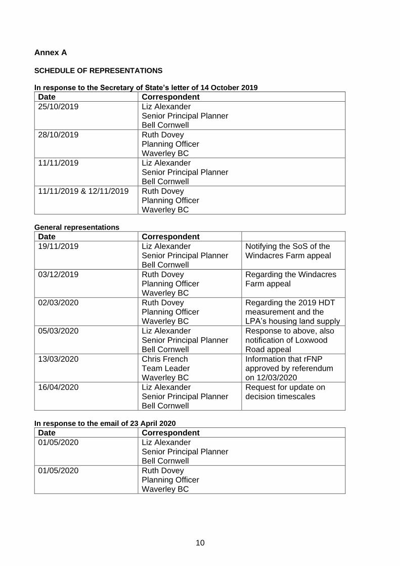
Annex A
SCHEDULE OF REPRESENTATIONS
In response to the Secretary of State’s letter of 14 October 2019
Date Correspondent
25/10/2019 Liz Alexander Senior Principal Planner Bell Cornwell
28/10/2019 Ruth Dovey Planning Officer Waverley BC
11/11/2019 Liz Alexander Senior Principal Planner Bell Cornwell
11/11/2019 & 12/11/2019 Ruth Dovey Planning Officer Waverley BC
General representations
Date Correspondent
19/11/2019 Liz Alexander Senior Principal Planner Bell Cornwell
Notifying the SoS of the Windacres Farm appeal
03/12/2019 Ruth Dovey Planning Officer Waverley BC
Regarding the Windacres Farm appeal
02/03/2020 Ruth Dovey Planning Officer Waverley BC
Regarding the 2019 HDT measurement and the LPA’s housing land supply
05/03/2020 Liz Alexander Senior Principal Planner Bell Cornwell
Response to above, also notification of Loxwood Road appeal
13/03/2020 Chris French Team Leader Waverley BC
Information that rFNP approved by referendum on 12/03/2020
16/04/2020 Liz Alexander Senior Principal Planner Bell Cornwell
Request for update on decision timescales
In response to the email of 23 April 2020
Date Correspondent
01/05/2020 Liz Alexander Senior Principal Planner Bell Cornwell
01/05/2020 Ruth Dovey Planning Officer Waverley BC
Hearing Held on 25 - 26 June 2019 Hawthorns, Bells Piece, Farnham GU9 9RL
Appeal Reference: APP/R3650/W/18/3211033
https://www.gov.uk/planning-inspectorate
Report to the Secretary of State for Housing, Communities and Local
Government by Graham Chamberlain BA (Hons) MSc MRTPI
an Inspector appointed by the Secretary of State
Date: 15 August 2019
TOWN & COUNTRY PLANNING ACT 1990
APPEAL BY STAX DEVELOPMENTS LTD AGAINST THE DECISION OF WAVERLEY BOROUGH COUNCIL
LAND AT
HAWTHORNS, BELLS PIECE, FARNHAM, SURREY GU9 9RL

Report APP/R3650/W/18/3211033
https://www.gov.uk/planning-inspectorate
CONTENTS
Background
Preliminary Matters 1
Site and its Surroundings 1
The Proposal 2
Planning Policies 5
Agreed Matters 9
The Case for the Appellant 13
The principle of development - Policies concerned with the location of housing
The effect on the landscape
The design and layout of the proposal
The effect on the Thames Basin Heaths Special Protection Area
Whether any conflict with the development plan is outweighed by other material
considerations
The Case for the Council 23
The principle of development - Policies concerned with the location of housing
The effect on the landscape
The design and layout of the proposal
The effect on the Thames Basin Heaths Special Protection Area
Whether any conflict with the development plan is outweighed by other material
considerations
The Case for Interested Parties 28
Inspector’s Conclusions 30
The principle of development - Policies concerned with the location of housing
The effect on the landscape
The design and layout of the proposal
The effect on the Thames Basin Heaths Special Protection Area
Planning Obligations
Whether any conflict with the development plan is outweighed by other material
considerations
Planning Conditions 41
Recommendation 42
LIST OF APPEARANCES 43
LIST OF DOCUMENTS SUBMITTED AT THE HEARING 43
RECOMMENDED CONDITIONS (IF PLANNING PERMISSION IS GRANTED) 44
Report APP/R3650/W/18/3211033
https://www.gov.uk/planning-inspectorate Page 1
Appeal Ref: APP/R3650/W/18/3211033
Hawthorns, Bells Piece, Farnham, Surrey GU9 9RL
• The appeal is made under section 78 of the Town and Country Planning Act 1990 against
a refusal to grant planning permission.
• The appeal is made by Stax Developments Ltd against the decision of Waverley Borough
Council.
• The application, Ref WA/2017/2352, dated 11 December 2017, was refused by notice
dated 9 March 2018.
• The development proposed is described as ‘Demolition of existing house and buildings;
creation of new access off Hale Road. Development of up to 65 mixed dwellings to include
40% affordable housing, creation of open space to act as SANG extension to Farnham
Park (inc. small public car park). Associated landscape and infrastructure’.
Summary of Recommendation: That the appeal is allowed and planning permission is granted subject to the conditions in the attached schedule.
Preliminary Matters
1. During the hearing both the Council and the appellant submitted, and referred to,
late evidence. The documents submitted are listed towards the end of this report. This evidence was not overly detailed or lengthy, was relevant to the matters
under consideration and was capable of being addressed by the parties following short adjournments. I therefore accepted the late evidence as no party was
significantly prejudiced by this course of action. Similarly, the highways information1 was submitted at the outset of the appeal and therefore all parties have had a reasonable opportunity to consider it.
2. Following discussions at the hearing it became apparent that the submitted planning obligation required extensive redrafting. It was agreed by the Council
and appellant that the alterations were resolvable and could be made reasonably quickly. As such, a two-week extension was given to finalise the document. An engrossed unilateral undertaking was submitted on the 9 July 2019. The Council
subsequently confirmed that the document has been properly executed and includes the obligations necessary to address the relevant reasons for refusal.
The obligations secured are a material consideration that are considered later in this report.
The Site and its Surroundings
3. The appeal site and its surroundings are described in detail in the Design and Access Statement2 and the Outline Landscape Appraisal3 prepared on behalf of
the appellant. These documents include some useful contextual plans. There is further description in the Officer’s report to the planning committee and the Statements of Case submitted by both the appellant and the Council.
4. In brief, the appeal site is about 2.82 hectares in size4 and is located on the north eastern fringe of Farnham. It encompasses a large detached house (Hawthorns),
its garden and adjoining paddocks. Hawthorns is currently accessed from Hale
1 Transport Assessment by WSP, Road Safety Audit and Designers response to the Road Safety Audit 2 Design and Access statement dated November 2016 by DHA Architecture Ltd – see pages 6-12 3 Outline Landscape Appraisal dated February 2016 by Floyd Matcham Charted landscape Architects 4 As confirmed on drawing 021515-STAX-M11 A, which was accepted as being accurate by the Council at the hearing
Report APP/R3650/W/18/3211033
https://www.gov.uk/planning-inspectorate
Road along a private drive/track shared with Bells Piece, a Leonard Cheshire day centre and residential care home located to the south of the appeal site.
5. On entering the private drive/track there is the car park of the Six Bells Public House to the south and a small field to the north used by the residents and operators of Bells Piece for horticulture and occasional events. Beyond this there
is a long gravel drive, the entrance to which is marked by domestic style entrance gates. It leads to Hawthorns and skirts the eastern and northern
boundaries of a small paddock that includes a cluster of trees and a small area of hardstanding used as a car park. It is enclosed by a conifer hedge and this affords the paddock a semi-domestic appearance.
6. To the north of the ‘conifer paddock’ is another area of grassland. The appellant suggests this is part of the residential curtilage of Hawthorns, but it does not
have an overly manicured appearance that would suggest this is the case. Nevertheless, it is enclosed by a domestic style post and rail fence and has been mowed. This affords the paddock a semi-domestic appearance. The remainder of
the site includes a long meadow/paddock which adjoins the Nadder Stream, and a further paddock abutting Hale Road (B3007). These latter parcels of land have
a more natural and unmanaged appearance. There is mature boundary treatment with Farnham Park to the west, Hale Road to the east and the land
beyond the Nadder Stream to the north. Farnham Park is a registered park and garden and a very attractive public open space between Farnham and Hale.
7. To the south of the appeal site is Scholars Way, a public footpath that links Hale
Road with Farnham Park, Farnham Castle and the Town Centre. In the vicinity of the appeal site this is flanked, in part, by brick walls marking the boundaries of
the properties in Osborn Road and Haven Way. The Scholars Way is a physical feature that broadly marks the northern extent of the settlement boundary of Farnham. Hale Road links the Six Bells roundabout with the A325 and is therefore
an important route into Farnham. On the eastern side of Hale Road, and opposite the appeal site, are allotments, a petrol filling station and the entrance to Roman
Way, a predominately residential cul-de-sac.
The Proposal
8. There are useful descriptions of the appeal proposal in the Planning Statement5,
Design and Access Statement, the Officer’s committee report and the Statements of Case prepared by the appellant and Council.
9. In summary, the planning application is a ‘hybrid’ with elements of detail advanced for approval and other submitted in outline. The details include the creation of a public open space/SANG6 extension with the drawings showing the
location, size and design of this element of the proposal. However, the Local Area of Play (LAP) shown on the drawings may need to be substituted for a Local
Equipped Area of Play (LEAP) depending on the outcome of the appeal, a point I discuss later. The proposal for up to 65 homes has been submitted in outline with all matters of detail reserved for future consideration save for the access.
10. The proposed access would be taken from Hale Road and would involve the construction of a new T-junction. Detailed drawings have been submitted
5 Planning Statement dated December 2017 by Bell Cornwell - see p5 6 Semi Natural Accessible Greenspace – this is proposed as an extension to the Farnham Park SANG or as a public
open space private owned by a management company but publicly accessible

Report APP/R3650/W/18/3211033
https://www.gov.uk/planning-inspectorate
showing this7. The application is supported by an indicative landscape character plan8 showing how the residential element of the scheme could be laid out. The
proposal would include 40% affordable housing.
11. The SANG extension is proposed to mitigate the scheme’s impact upon the integrity of the Thames Basin Heaths Special Protection Area (SPA)9. For reasons
I set out later the Council are not satisfied by this approach. Thus, the appellant is alternatively proposing to make a financial contribution towards the
maintenance and management of the Farnham Park SANG if it is found that the SANG extension is not appropriate mitigation10. In this second scenario the open space proposed as a SANG extension would instead be a public open space
privately owned by a management company.
12. If the Secretary of State is minded to allow the appeal and grant planning
permission, and in doing so finds, following an appropriate assessment, that Scenario 2 is the appropriate means of mitigating the scheme’s effect on the integrity of the SPA, it is recommended that the description of development, as
taken from the application form, should be amended to the following11:
Demolition of existing house and buildings; creation of new access off Hale Road.
Development of up to 65 mixed dwellings to include 40% affordable housing, creation of public open space (inc. small public car park). Associated landscape
and infrastructure.
13. No party would be significantly prejudiced by amending the proposal and the description of development in this way because Scenario 2 would not result in
any changes to the drawings and a publicly accessible open space would still be provided. The difference rests in the ownership and function of the public open
space and whether it can be a SANG extension and managed as such. Interested parties have had a chance to make representations on this point and did so at the hearing. These are summarised later. The appellant submitted useful written
representations on this point at the hearing outlining the relevant legislation12 and the powers a decision taker has to consider an amendment. This advice was
unchallenged by the Council.
14. A signed planning obligation in the form of a unilateral undertaking was before the hearing. However, in the related discussion, several drafting errors were
identified and some minor points of disagreement. A revised unilateral undertaking was submitted after the hearing.
15. Both the Council and the appellant have addressed the tests for the obligations in their submissions13. I have also been provided with the Council’s Thames Basin Heaths Special Protection Area Avoidance Strategy14 as evidence underpinning
some of the obligations. The unilateral undertaking secures the following:
• The provision of 40% affordable housing;
7 Drawings 16438-SK-003 and 9349/02 8 Drawing 569.3/08 9 I refer to the proposal for a SANG extension as ‘Scenario 1’ 10 I refer to the financial contrition toward SANG maintenance as ‘Scenario 2’ 11 Which in substance is the same as that recommended by the Council in its Statement of Case – Paragraph 8 12 Doc 6 submitted at the hearing – see the list at the end of this report 13 Paragraph 204 of the Framework and the statutory requirements of Regulations 122 and 123 of the Community
Infrastructure Levy Regulations 14 Doc 12 submitted to the hearing
Report APP/R3650/W/18/3211033
https://www.gov.uk/planning-inspectorate
• The provision and management of an onsite Local Equipped Area of Play;
• Financial contributions towards sustainable transport comprising bus stop
improvements (£20,000) cycle safety improvements (£20,000), footway and cycle improvements (£20,000) and travel vouchers for future residents (£100 per household).
• A means of mitigating the impact of the development on the integrity of the Thames Basin Heath Special Protection Area through either a SANG extension
or financial contributions to both the operation and maintenance of SANG and Strategic Access Management and Monitoring (SAMM).
16. The merits of the obligations and the extent to which the various provisions
satisfy the relevant tests are appraised in my conclusions below.

Report APP/R3650/W/18/3211033
https://www.gov.uk/planning-inspectorate
Planning Policies
17. The planning policy context has evolved since the planning application was first
submitted to the Council on the 11 December 2017. The most up to date positions of the Council and appellant are set out in their respective Statements of Case and the agreed Statement of Common Ground.
18. The development plan for the purposes of this appeal includes a saved policy in the South East Plan 2009, saved policies in the Waverley Borough Local Plan
2002, the Waverly Local Plan Part 1: Strategic Policies and Sites adopted February 2018 and the Farnham Neighbourhood Plan made on 28 July 2017.
19. The following is a summary of the development plan policies referred to and
considered to be the most relevant to the issues raised by this appeal. The following summary also sets out the emerging policies not yet part of the
development plan but referred to by the parties as material considerations.
The South East Plan 2009 (SE Plan)
20. The SE Plan was revoked in 2013, except for Policy NRM6. The appeal site is
located within 400m-5km of the Thames Basin Heaths Special Protection Area (SPA) and this retained policy requires that new residential development within
that zone should include the provision of adequate measures to avoid or mitigate any potential adverse effect on the ecological integrity of the SPA.
Saved Policies of The Waverley Borough Local Plan 2002 (WBLP)
21. Policy D1: Development will not be permitted where it would result in material detriment to the environment by virtue of loss or damage to important
environmental assets, including areas of landscape value, or harms the visual character of the locality.
22. Policy D4: The Council will seek to ensure that development is of a high-quality design which integrates well with the site and complements its surroundings.
23. The Council’s reasons for refusal refer to Policies H5 and H10 of the WBLP, but
both policies have been deleted following the adoption of the WLPP1. Policy H5 has been superseded by Policy AHN1 of the WLPP1 and Policy H10 by Policies
TD1 and LRC1 of the WLPP1.
Waverly Local Plan Part 1: Strategic Policies and Sites 2018 (WLPP1)
24. Policy SP2: To maintain Waverley’s character, whilst ensuring that development
needs are met in a sustainable manner, the spatial strategy is to focus development on the four main settlements (Farnham, Godalming, Haslemere and
Cranleigh) with further development at other settlements depending on their size and the applicable planning designations. The policy also seeks to maximise opportunities for the redevelopment of suitable brownfield sites and states that in
addition to the strategic sites allocated in WLPP1, additional sites will be allocated through the Waverley Local Plan Part 2 and neighbourhood plans.
25. Policy ALH1: Through this policy the Council makes provision for at least 11,210 net additional homes in the period from 2013 to 2032 (equivalent to at least 590 dwellings a year). Farnham is allocated the most, with a minimum of 2,780
homes to be delivered here over the plan period.
Report APP/R3650/W/18/3211033
https://www.gov.uk/planning-inspectorate
26. Policy RE1: Seeks, in accordance with the Framework, to recognise and safeguard the intrinsic character and beauty of the Countryside Beyond the
Green Belt, an area defined on the adopted Policies Map.
27. Policy RE3: Seeks to ensure new development respects and where appropriate enhances the distinctive character of the landscape in which it is located. The
Area of Great Landscape Value (AGLV) is to be retained for its own sake and as a buffer to the Surrey Hills Area of Outstanding Natural Beauty (AONB) until there
is a review of the AONB boundary. The policy recognises that the protection of the landscape should be commensurate with its status as a local landscape designation. The policy draws a distinction between the degree of protection
afforded to areas covered by national landscape designations compared with those covered by local designations.
28. Policy TD1: Seeks to ensure that the character and amenity of the Borough is protected by requiring, amongst other things, that new development is of a high quality that responds to local character.
29. Policy NE1: Seeks to conserve and enhance biodiversity within the Borough.
30. Policy NE3: New residential development which is likely to have a significant
adverse effect on the ecological integrity of the SPA will be required to demonstrate that adequate measures are put in place to avoid or mitigate any
potential adverse effects. New residential development that either alone or in combination is likely to have a significant adverse effect on the SPA beyond 400m and within 5 km of the SPA boundary (in a straight line) must provide:
• Appropriate contributions towards the provision of Suitable Alternative Natural Greenspace (SANG) identified by the Council15; or
• A bespoke solution to provide adequate mitigation measures to avoid any potential adverse effects; and
• A financial contribution towards wider Strategic Access Management and
Monitoring (SAMM).
31. Policy LRC1: Seeks to secure formal outdoor play space in accordance with Fields
in Trust Standards. A scheme proposing 10 or more homes is required to provide a Local Equipped Area of Play (LEAP) in accordance with the specifications set out in Table 1 in the supporting text to the policy.
32. Policy ICS1: Seeks to ensure that the infrastructure considered necessary to support new development is provided either on-site or off-site through planning
conditions and planning obligations.
33. Policy ST1: Seeks to ensure new development schemes are located where opportunities to maximise sustainable transport modes, including measures to
include non-car use.
34. Policy AHN1: Through this policy the Council will require a minimum provision of
30% affordable housing where 11 dwellings or more is proposed.
15 In the Council’s Thames Basin Heaths Special Protection Area Avoidance Strategy Review 2016 updated 2018
Report APP/R3650/W/18/3211033
https://www.gov.uk/planning-inspectorate
35. Policy CC4: This policy states that sustainable drainage systems will be required as part of major developments.
Farnham Neighbourhood Plan 2017 (FNP)
36. Policy FNP1: Seeks to secure development that is designed to a high quality and responds to the heritage and distinctive character of Farnham.
37. Policy FNP10: This policy seeks to protect and enhance the countryside. Its states that outside of the Built-Up Area Boundary16 (BUAB) priority will be given to
protecting the countryside from inappropriate development. A proposal for development outside the BUAB will only be permitted where it would be in accordance with Policies FNP16 (Building Extensions), FNP17 (Land for Business)
and FNP20 (Rural Buildings for Business and Tourism Uses) or other relevant planning policies applying to the area. An example of ‘other relevant policies’
given by the Council at the hearing was the housing allocations in Policy FNP14.
38. Policy FNP11: This policy is aimed at preventing coalescence between Farnham and Aldershot and the other settlements in the FNP area. It states that
development proposals outside the BUAB will be assessed in terms of their potential impact on the visual setting and landscape features of the site and its
surroundings, and the potential impact on biodiversity, traffic and noise. Proposals that fail to demonstrate that these impacts can be satisfactorily
addressed, or which clearly lead to increased coalescence, will not be supported.
39. Policy FNP12: This policy broadly repeats the requirements of Policy NE3 of the WLPP1, although any contributions towards SANG are to be spent at Farnham
Park.
40. Policy FNP13: Proposals should protect and enhance biodiversity by protecting
Special Protection Areas, preserving and extending ecological networks and promoting biodiversity enhancement.
41. Policy FNP30: Seeks to secure acceptable transport impacts from development
including safe access. It also requires the submission of travel plans and seeks to secure residential proposals that do not add significantly to congestion, by
ensuring a sustainable transport network.
42. Policy FNP32: Seeks to secure the provision of the necessary social, physical and green infrastructure needed to support a proposed development.
The draft Farnham Neighbourhood Plan (dFNP)
43. The made FNP aims to provide around 2,201 homes over the period 2013-2031.
This figure was based on the pre adoption draft of the WLPP1. During the examination of the WLPP1 the housing requirement for Waverley was increased to take account of the unmet needs of Woking Borough. The result being that the
WLPP1 now requires Farnham to provide at least 2,780 homes. Thus, the made FNP does not fully meet the local housing requirement.
16 Defined on Map A, Page 19 of the FNP

Report APP/R3650/W/18/3211033
https://www.gov.uk/planning-inspectorate
44. Accordingly, the draft Farnham Neighbourhood Plan Review17 is being prepared and this will allocate additional housing along with other amendments18. The
analysis in the dFNP indicates that with allocations for a further 450 homes, the housing requirement for Farnham in the WLPP1 would be met. The current proposal is for the additional housing allocations to be sites within the BUAB of
Farnham (see draft Policy FNP14 (k) – (q) of the dFNP).
45. The Independent Examiner of the dFNP held a Procedural Exploratory Meeting on
the 4 June 2019 to consider the question of whether the modifications in the dFNP are so significant and substantial as to change the nature of the made FNP, which the dFNP would replace. He has concluded in his letter of the 21 June
201919 that they would, and therefore the dFNP requires full examination and referendum before it can be made.
The draft Waverley Local Plan Part 2 (dWLPP2)
46. The Council consulted on the Preferred Options version of the dWLPP2 between May and July 2018. The Council is now in the process of preparing the pre-
submission version of the plan. The Council intends to publish this for consultation in the Summer of 2019 with a view to submitting it for examination
in the of Winter 2019. The Council has confirmed in its Statement of Case (Paragraph 38) that there are no policies within the dWLPP2 that would affect the
consideration of the appeal scheme. Consequently, the Council has not referred to any within its submissions.
17 See Appendix 5 of the Council’s Statement of Case for the draft document 18 These are succinctly listed in the Independent Examiners letter to Farnham Town Council dated 21 June 2019 –
Doc 8 submitted to the hearing 19 Ibid
Report APP/R3650/W/18/3211033
https://www.gov.uk/planning-inspectorate
Agreed Matters
47. The submissions of the Council and the appellant, discussions at the hearing and
the Statement of Common Ground (SOCG), confirm that several points are not in dispute and are agreed. There is no sufficiently compelling evidence before me that demonstrates different findings on these points would be justified. The
following list includes several matters of agreement between the Council and the appellant:
• The site is located outside the BUAB of Farnham and is therefore in the countryside;
• The appellant’s Acoustics Site Suitability Assessment has adequately
explained the likely noise impacts of the proposed development and advanced noise mitigation measures. In addition, planning conditions can be
imposed to ensure the internal and external noise levels at the proposed dwellings would conform to relevant guidelines and to secure the provision of a Construction Environmental Management Plan;
• The appellant’s Air Quality Assessment Report and subsequent email of the 23 February 2017 submitted with the application demonstrates that the
application is acceptable in respect of these matters. A point endorsed by the Council’s Environmental Health Officer;
• There would be no adverse impacts on protected species, subject to the mitigation measures set out in the Ecological Appraisal submitted by the appellant. A point supported by the Surrey Wildlife Trust;
• Whilst the proposed layout is indicative, it demonstrates that the quantum of development proposed could be achieved on site whilst maintaining a good
level of amenity for existing neighbours. Substantive evidence has not been provided to demonstrate that the proposal would have an adverse impact on the residents of Bells Piece. Control over construction hours would prevent
sleep disturbance;
• The proposed SANG extension/public open space (POS) would result in the
intensification of the use of what is currently a field/paddock area. However, there are no residential dwellings immediately adjoining this area and therefore the increased use of the site resulting from its SANG/POS status
would not unacceptably harm neighbouring residential amenity;
• The indicative housing mix would broadly respond to the Borough’s housing
needs as set out in the West Surrey Strategic Housing Market Assessment 2015 (SHMA);
• A suitable layout could be provided at the detailed design stage that would
ensure an appropriate buffer between the development and Farnham Park, thus ensuring the setting of the park is preserved. Subject to the provision of
a buffer at detailed design stage, the development would not harm the setting or significance of this designated heritage asset. Given that the public open space would involve limited intervention and preserves the existing
landscape character, this element of the development also preserves the setting of the park;
• The proposal would not result in coalescence;
Report APP/R3650/W/18/3211033
https://www.gov.uk/planning-inspectorate
• Subject to conditions, there would be no harm to archaeology;
• The density of the development is that set out on drawing 021515-STAX-
M11. The Council acknowledges that the density is not that set out in the Officer’s report – it would be in the region of 37 dwellings per hectare on the net developed area;
• The proposal could be designed to ensure adequately sized gardens for future occupants alongside internal space to meet national housing standards such
as the Technical housing standards – nationally described space standards;
• The appeal site does not have an agricultural holding number and has been used for domestic purposes and the keeping of horses since 1995. Even if
considered to be agricultural land, it is not the best and most versatile (it is Grade 3). In the circumstances, the loss of the agricultural land to another
use would be acceptable.
48. The SOCG confirms that the following matters, set out in some of the reasons for refusal have been resolved:
• The Council does not wish to pursue the third reason for refusal because the submitted planning obligation makes provision for a financial contribution
towards SANG and SAMM as the means of mitigating the proposal’s effect on the SPA. Nevertheless, the Council would pursue the third reason for refusal
if the appellant intends to mitigate the impact on the SPA through the originally proposed SANG extension;
• Since the Council issued its decision it has adopted a Community
Infrastructure Levy. Consequently, the Council is no longer seeking to secure financial contributions towards education, leisure and recycling containers
through a planning obligation. Thus, it is not pursuing the forth reason for refusal in so far as it relates to these matters. Moreover, there is no substantive evidence that the appeal scheme wold place harmful pressure on
other infrastructure, such as the public sewer or health facilities;
• The planning obligation secures 40% affordable housing and therefore the
Council does not wish to pursue the fifth reason for refusal;
• If the effect on the SPA is mitigated through Scenario 2 then there would be space within the public open space to provide a LEAP, which would be
secured through the planning obligation. In such circumstances, the Council does not wish to pursue the sixth reason for refusal;
• The submitted highways information, and the planning obligation pertaining to highway works, would address the seventh reason for refusal, which the Council no longer wishes to pursue. The information demonstrates that the
appeal scheme would provide a safe and suitable access and would not result in significant impacts on the transport network and congestion;
• The Lead Local Flood Authority has confirmed20 that a surface water drainage strategy can be secured through the imposition of a planning condition. Having received this advice, the Council does not wish to pursue the eighth
reason for refusal subject to the imposition of a suitably worded planning condition.
20 Email of the 19 March 2019 appended to the appellant’s final comments dated 19 March 2019

Report APP/R3650/W/18/3211033
https://www.gov.uk/planning-inspectorate
49. The SOCG goes on to list the relevant policies, confirms the plans and documents the Council’s decision was based upon and indicates that Council’s list of
suggested planning conditions is agreed. Section 5 of the SOCG lists several technical points that are agreed including the site’s close proximity to the town centre. The SOCG also agrees several matters relating to housing land supply,
which are:
• The housing requirement is agreed at 590 dwellings per annum. The Local
Plan Examiner concluded that there was a 5.2-year housing land supply at 1 April 2018, which included a 5% buffer;
• The Housing Delivery Test measurement in 2018 for Waverley was 79%
meaning that a 20% buffer should be applied. The Council’s most up to date position on five-year housing land supply is set out within its Five-Year
Housing Land Supply report dated 1 April 201821. There is currently no update to this;
• The shortfall from 2013 to date (of 1390 homes) should be made up in the
five-year period. It was agreed at the hearing that the five-year period for the purpose of this appeal is 2018 – 2023. The housing requirement for this
period is 520822 homes giving a revised annual housing requirement of 1041 homes23.
21 See Appendix 9 of the Council’s Statement of Case 22 590 x5 = 2950 + 1390 = 4340 + 868 = 5208 23 5208/5
Report APP/R3650/W/18/3211033
https://www.gov.uk/planning-inspectorate
Main Considerations
50. I tabled draft main considerations at the hearing as part of my agenda, which
were subsequently agreed by the parties present. The discussions and the respective cases of the parties were structed around the main considerations.
51. As set out above, the areas in dispute between the Council and the appellant
have been narrowed through the submission of the planning obligation and the additional highways information. Therefore, the Council only pursued the first and
second reasons for refusal at the hearing and the third if Scenario 1 is advanced as a means of mitigating the impact on the SPA.
52. The Council did not include a discrete reason for refusal in its decision notice that
explicitly relates to the location of the proposal outside the Built-up Area Boundary (BUAB) of Farnham. Nevertheless, the Officer’s report indicates that
the principle of development is unacceptable and interested parties have raised concerns regarding the appeal site’s location outside the BUAB and in the countryside. I therefore addressed this as a main consideration at the hearing
and have done so in this report. The main considerations flow from the reasons for refusal still in dispute and the submissions, which I have summarised below.
These are as follows:
• Whether the proposed development would be in a suitable location, with
particular reference to policies concerned with the location of housing;
• The effect of the proposed development on the landscape;
• Whether an acceptable design and layout can be achieved;
• The effect of the proposed development on the Thames Basin Heaths Special Protection Area; and
• Whether any conflict with the development plan is outweighed by other material considerations.
Report APP/R3650/W/18/3211033
https://www.gov.uk/planning-inspectorate
The Case for the Appellant
53. The following is a summary of the material points in the appellant’s written
submissions and the oral evidence heard during the hearing.
Whether the proposed development would be in a suitable location, with particular reference to policies concerned with the location of housing
54. It is pertinent that there is no reason for refusal regarding the principle of development. The Council has not argued that the scheme is contrary in principle
to the development plan due to its location outside the BUAB. Instead, Policy SP2 of the WLPP1 states that development will be focussed on the four main settlements of Farnham, Godalming, Haselmere and Cranleigh. The appeal
scheme, being on the edge of Farnham, would achieve this aim and would provide housing in a location with good connectivity to the facilities and services
in the town centre.
55. The proposal would conflict with Policy FNP10a) of the FNP in that it would be development outside the BUAB of Farnham, which would not be in accordance
with Policies FNP16, FNP17 and FNP20. However, Policy FNP10 must be read alongside Policy FNP11 of the FNP. This states that development proposals
outside the BUAB of Farnham will be assessed in terms of their potential impact upon the visual setting and landscape features of the site and its surroundings,
and the potential impacts on biodiversity, traffic and noise. Accordingly, the spatial strategy in the FNP, when read as a whole, is an impact-based approach. The proposal would not result in harmful impacts upon any of the matters listed
in Policy FNP11, including coalescence.
56. There is an internal inconsistency between Policies FNP10 and FNP11, whereby
the former seeks to prevent development outside the BUAB other than in narrow circumstances and the latter permits it when there would be no harmful impacts from doing so. In this instance, there would be no harmful impact upon the
landscape, biodiversity and traffic from breaching the settlement boundary and therefore the proposal would adhere to Policy FNP11. There would be little sense
in preventing development via Policy FNP10 when it would have no harmful impacts and is consistent with Policy FNP11. Thus, there is no in principle conflict with the FNP when read as a whole.
57. The appeal site is therefore a suitable location for housing when considered against the policies in the development plan.
The effect of the proposed development on the landscape
58. The planning application was supported by a professional prepared Outline Landscape Appraisal prepared in February 2016 updated in October 2016. It
considers landscape character, the landscape designations, visual setting and the landscape and visual impacts of the proposal. The appellant broadly relies on the
findings of this report in considering the effects on the landscape.
Landscape Character
59. The Outline Landscape Appraisal explains that the appeal site is identified in the
Surrey Landscape Character Assessment as being located within Landscape Character Area LF6: North Farnham Rolling Clay Farmlands. The key
characteristics of this landscape type includes:
Report APP/R3650/W/18/3211033
https://www.gov.uk/planning-inspectorate
• Undulating clay farmland falling towards the River Wey and minor local valley features elsewhere;
• A mixture of medium scale arable fields, smaller pastoral fields and a few low-key paddocks along with blocks of woodland and tree belts;
• Watercourses often associated with riparian woodland;
• Farnham Park (Grade II listed) covers a large area between Hale and Farnham;
• Tree cover limits or frames long-distance views and screens most of the built-up areas;
• Most of the character area is a pleasant, relatively peaceful, rural landscape.
Urban influence from the built-up areas and roads increase at the eastern end of the character area.
60. The evaluation of the LF6 landscape character area identifies positive landscape attributes and forces for change/sensitivities/pressures. Positive landscape attributes/elements are farmland, woodland blocks and meadow pasture. Under
forces for change/sensitivities and pressures, the landscape character assessment recognises that there is continued demand for horse paddocks and
pressure for residential development through edge of town and infilling development. The assessment also refers to loss of hedgerows and trees.
Guidance for the LF6 landscape character area is directed at conserving the area’s pastoral landscape character.
61. The appeal site is not representative of the wider landscape in the LF6 Character
Area because the site has an enclosed semi-domestic character, rather than a farmland character, due to the presence of buildings (Hawthorns), a long
driveway, a large domestic curtilage, equestrian paddocks and a long conifer tree belt. In this respect, it is neither urban nor rural and can therefore be developed without appearing as a discordant breach of the BUAB.
62. The appeal site also falls within the Cemetery Fields Landscape Character Area defined in the Farnham Landscape Character document24, a background study
that has informed the preparation of the FNP. The character area is described in the study as being of high landscape sensitivity and high landscape value and is therefore within the defined Area of High Landscape Sensitivity and Historic Value
(AHLS)25. Nevertheless, being well screened and semi domestic in character the appeal site does not incorporate the important features of the Cemetery Fields
Character Area and therefore the appeal site should not be considered as being of high landscape sensitivity or value. Accordingly, the proposal would not conflict with the aims of the AHLS designation.
The AGLV Designation
63. A statutory landscape designation does not cover the appeal site or the
surrounding area. The boundary of the Surrey Hills AONB lies to the south-east of Farnham. The Surrey Area of Great Landscape Value (AGLV) is a non-statutory
24 Doc 3 submitted at the hearing 25 Map E, p35 of the FNP

Report APP/R3650/W/18/3211033
https://www.gov.uk/planning-inspectorate
landscape designation extending across the site. It takes in Farnham Park and adjoining countryside to the north and extends east as far as Hale Road. The
Surrey AGLV has been the subject of two reviews commissioned by the Surrey Local Authorities in 2007 and 2013.
64. The latest review did not recommend that any of the AGLV on the northern side
of Farnham should be included in the AONB. The justification for retention of the AGLV in order to fulfil a ‘buffer’ role could not apply on the north-western side of
Farnham where the AGLV is not contiguous with the AONB or any existing area of AGLV that may be ‘upgraded’ to AONB status. The status of the AGLV remains unclear but in its current form it is preventing the housing needs of Farnham
from being met as sites within the AGLV are rejected from being allocated in the development plan in a blanket fashion.
65. The Council gives unsubstantiated and unjustified weight to protecting the AGLV. The AGLV designation is, factually, a local designation that should not be given the weight of the national designation of the AONB. Policy RE3 is confusing and
contradictory, with the policy firstly saying that ‘the same principles for protecting the AONB will apply in the Area of Great Landscape Value (AGLV)……’
and then continuing to state later in the same sentence ‘…whilst recognising that the protection of the AGLV is commensurate with its status as a local landscape
designation’. The AGLV is a dated landscape designation that acts as a barrier to finding suitable and sustainable sites on the edge of Farnham.
Visual setting
66. The analysis of representative views in Appendix 2 of the Outline Landscape Appraisal demonstrates the site is visually well-enclosed by surrounding
vegetation and cannot be seen easily in public views. There are glimpsed views of the buildings on Bell’s Piece from the western end of The Avenue in Farnham Park, but no clear public views from north or south. The site cannot be seen
clearly in public views from the footpath following the eastern side of Farnham Park but there is a glimpsed view along the northern boundary where this path
crosses the Nadder Stream. In winter, there are glimpsed views of the appeal site between trees on Hale Road, but these views do not show the entire site.
Landscape and Visual Analysis
67. Other than its gently sloping landform26, the site does not share the main landscape characteristics of the LF6: North Farnham Rolling Clay Farmlands. It
has a more domestic and enclosed character that is distinct from the pastoral farmland character seen elsewhere in the landscape character area, particularly to the west of Folly Hill and across the fields to the north of the appeal site, which
lie between Hale Road and Farnham Park
68. The Outline Landscape Appraisal identifies that the landform across most of the
site is suitable for accommodating new residential development but the design of any development on the slope down to the Nadder Stream would require careful design. Accordingly, this section of the site would be left undeveloped and
incorporated into an area of public open space. This arrangement would help to preserve the setting of the Nadder Stream.
26 See topographical survey Drawing 1311/2 for site contours

Report APP/R3650/W/18/3211033
https://www.gov.uk/planning-inspectorate
69. The Outline Landscape Appraisal also states that internally, the existing distribution of vegetation is not a constraint to development. The coniferous tree
line is an incongruous feature and would be removed. It may be possible to retain other individual (mainly deciduous) trees and tree lines and incorporate them into the scheme design, although this would require further consideration
at the reserved matters stage.
Visual constraints and opportunities
70. The site is visually very well contained with no clear public views directly into the site. Provided boundary vegetation is retained in line with the indicative layout, new development would be visually well-contained. The site therefore provides a
good opportunity for accommodating new residential development on the northern side of Farnham that would generate very limited visual change.
Internally, there are no major visual constraints that would affect layout design. However, in order to maintain an attractive visual character within the development, it would be desirable to avoid houses and gardens backing directly
onto the Nadder Stream. The indicative layout shows this can be achieved and that the existing attractive visual setting of the stream could be retained.
Likely Landscape and Visual Effects
71. The site is partly domestic in character so residential development affecting the
existing buildings and their curtilages could be viewed as redevelopment rather than greenfield development. However, across the remainder of the site, a development scheme would nevertheless urbanise land identified as undeveloped
countryside.
72. It is accepted that the introduction of new built form is an adverse landscape
effect that cannot be fully mitigated. Nevertheless, the indicative scheme has been carefully designed to demonstrate how development could extend across the central and southern sections of the site but leave the northern part of the
site adjoining the Nadder Stream undeveloped as public open space.
73. Use of the northern part of the site along the Nadder Stream as public open
space (in conjunction with the adjoining Farnham Park) would be a beneficial landscape effect. Importantly, users of Farnham Park would then be able to see and appreciate the full length of the Nadder Stream valley lying to the west of
Hale Road. The indicative layout demonstrates how a reasonably generous landscape scheme could be implemented which would be consistent with
achieving efficient use of the land for new residential development.
74. The development would not lead to the loss of any important characteristics of the landscape character area, in part because the site is not open farmed
countryside and because there would be no loss of important natural features such as notable native trees, hedgerows or woodlands. It is likely that some
other, mainly small trees would require removal, but they do not make a significant contribution to wider landscape character. Construction of the new site access would require the removal of a short section of the tree line on the
eastern boundary. This would be a negative landscape effect of local significance.
75. The proposal is for low-rise residential development. The visual assessment in
the outline landscape appraisal demonstrates that this would not generate significant or adverse visual effects within the wider area, including from Farnham Park. The site would remain substantially enclosed by mature boundary
Report APP/R3650/W/18/3211033
https://www.gov.uk/planning-inspectorate
vegetation. Moreover, the line of mature trees on the eastern boundary of the Leonard Cheshire site would visually separate the home from the application site.
It would be possible to obtain views into the new development along the site access road leading from Hale Road. This would not be perceived as a strongly negative effect in the context of the site’s setting close to an existing urban area
and busy main road.
Conclusions on Landscape Impact
76. In summary, the appeal site lies within Landscape Character Area LF6: North Farnham Rolling Clay Farmlands. Being semi-domestic in appearance the appeal site contains few of the landscape features that afford the character area its
significance. Therefore, it is not part of a valued landscape. The appeal site is visually contained by dense boundary landscaping. It can be developed
sensitively in a way that respects the wider landscape and the setting of the Nadder Stream.
77. The main constraint to developing the appeal site is the AGLV designation but
following recent detailed assessment work there are sound reasons why consideration should be given to removing the AGLV designation from the appeal
site and adjoining areas to the north-west of Farnham, as this area is not required as a buffer to the AONB.
Whether an acceptable design and layout can be achieved
78. The design rationale behind the illustrative layout is explained in detail in the Design and Access Statement.
79. The appeal scheme has been submitted in outline with matters of layout, landscaping, scale and appearance reserved for future consideration. As such,
there is considerable flexibility to devise a design and layout that would be suitable for the appeal site and its surroundings and include an appropriate housing mix that reflects the recommendations in the SHMA (40% of the private
dwellings and 70% of the affordable homes to be 1- and 2-bedroom properties).
80. The illustrative masterplan demonstrates how the proposal could be laid out in a
manner that respects the findings of the Outline Landscape Appraisal whilst using land effectively. The public open space, which is a fixed element of the proposal, would be located along the northern boundary of the site thereby maintaining the
meadow character and setting of the Nadder Stream. This would also link with Farnham Park providing an eastern connection from Hale Road. The housing
could be orientated to front onto the public open space thereby providing a sensitive interface. Generous planting in the front gardens and along the southern boundary of the open space would soften the edge of the housing area.
81. A feature building at the site entrance would provide legibility and a ‘gateway’ into the development. The access point into the site would breach the landscaped
eastern boundary but would not appear out of place given the surrounding context, with allotments, a large roundabout junction, a petrol station and a public house all in close proximity.
82. The housing would not be unduly cramped as each of the individual properties would benefit from gardens commensurate in size to those nearby and there is
nothing to suggest the proposed dwellings could not adhere to any space standards. The mews type character of the central section would allow for an
Report APP/R3650/W/18/3211033
https://www.gov.uk/planning-inspectorate
efficient use of land that would echo the formally laid out housing in Osborn Road and Haven Way and complement the Leonard Cheshire site. The density of the
net developed area would be 37 dwellings per hectare (dph) with the density of the entire site being 23dph. This is not high when compared to nearby housing and approved and planned development, including that allocated in the FNP.
There would also be opportunities to soften the internal street scape with street trees and landscaped front gardens.
83. A LEAP can be provided in the public open space if it is not to function as a SANG extension. If it is, then the LEAP can be accommodated within the housing area. This may require a reduction in housing numbers, but the proposal is for up to 65
homes so there would be scope for this.
The effect of the proposed development on the Thames Basin Heaths Special
Protection Area (SPA)
84. The intent of the application is to provide a generous area of open space in the northern section of the appeal site. The preference is for this to become an
extension to the Farnham Park SANG. However, this cannot be achieved without agreement from Natural England (NE) or the Council as owner of Farnham Park.
It has not been possible to achieve this agreement. This is of surprise as in 2006 Waverley Borough Council sent a letter to the landowner seeking additional land
in order to achieve a pedestrian access from Hale Road to Farnham Park.
85. The concept of providing a SANG extension as a means of mitigating the effect of a housing proposal on the SPA has been followed at other sites27, where Natural
England and Council agreed in principle to permit access and footpaths into the Farnham Park SANG (to be secured either by planning condition or obligation).
The appellant is still open to discussing and agreeing the provision of the open space as a SANG extension. This would have the following material benefits:
• It would achieve a seamless extension of Farnham Park eastwards towards
Hale Road.
• It would provide additional SANG capacity at the Borough’s only existing
resource for SANG.
• It would provide a public car park designed for dog walkers and leisure trips. The car park has been a long-sought ambition of the Council and would serve
the eastern area of the SANG.
• The provision of 1.12 hectares of SANG would provide capacity for an
additional 140 people.
86. However, as an alternative approach the appellant is proposing to offer the public open space and provide financial contributions towards the enhancement of the
existing SANG at Farnham Park, which currently has capacity and SAMM.
87. The submitted unilateral undertaking secures the above payments. Based on the
housing mix set out on the application form, and using the Council’s calculator in its avoidance strategy, this contribution has been calculated as £142,119. There is an additional £43,052 payable as a contribution towards SAMM. This would
27 Application reference WA/2017/1746 – Land at Farnham Park Hotel and Restaurant, Lower Hale, Farnham
Report APP/R3650/W/18/3211033
https://www.gov.uk/planning-inspectorate
ensure that there would be no adverse effect on the integrity of the SPA, either alone or in combination. This is entirely in keeping with the avoidance strategy,
which is supported by NE and was adopted by the Council on 19th July 2016.
Whether any conflict with the development plan is outweighed by other material considerations
88. The appellant maintains that the proposal would be compatible with the development plan, Policies SP2 and FNP11. However, if it is concluded that this
would not be the case then there are several material considerations that, taken collectively, outweigh any conflict with the development plan, thus suggesting permission should be forthcoming.
The relevant policies are out of date thereby triggering the tilted balance
89. The FNP, which was made in 2017, has been rendered swiftly out of date by the
adoption of the WLPP1, which has increased the housing target for Farnham beyond that currently addressed in the FNP. Therefore, the made FNP does not meet its identified housing requirement. The Inspector examining the WLPP1
indicated that it may be necessary to review the BUAB of Farnham in order to accommodate the additional housing, stating at Paragraph 99 of examination
report that ‘The amount of housing allowed for by the Neighbourhood Plan is too low……further housing allocations at Farnham will be necessary, with the probable
need to adjust the built up area boundary’.
90. The adoption of the WLLP1 has necessitated an immediate review of the FNP, which is underway. It is a fundamental review which seeks to make additional
allocations. The draft FNP should not hold any weight yet as there are concerns regarding the deliverability of the following sites required to meet Farnham’s
additional housing requirement. These being:
• The site at the University for the Creative Arts, Faulkner Road - This site is proposed for C2 uses (student accommodation). The Town Council considers
that the 217 net additional student units provided would equate to 72 dwelling units. However, the Planning Practice Guide urges caution with this
approach - whilst student accommodation can be counted towards the housing requirement, this is dependent on the amount of accommodation it releases in the housing market and it is important to avoid double counting.
As there is no evidence for this specific requirement, and no evidence that it will release other accommodation into the housing market, this proposed
allocation should be treated as a specialist requirement and counted as additional to, rather than as part of, the overall 450-dwelling requirement.
• Centrum Business Park in East Street Farnham - This is currently in use for
retail and industry and therefore it is unclear if the site can be assessed as deliverable. Policy EE2 of the WLPP1 seeks to protect existing employment
uses unless there is no reasonable prospect of the site or buildings being used or reused for these purposes. The Neighbourhood Plan must conform with the strategic policies of WLPP1 in order to meet the necessary basic
conditions and there looks to be a conflict in this regard. Additionally, the site has contamination issues. A very high density, presumably flatted
development is proposed, but there are broader issues with this not providing the necessary mix and type of dwellings that are required in terms of the
Report APP/R3650/W/18/3211033
https://www.gov.uk/planning-inspectorate
evidence in the SHMA28, and the potential to flood the market given the other similar flatted developments which are in the pipeline in the vicinity (for
example the Brightwells regeneration scheme).
• The Surrey Sawmill - This site is currently occupied by businesses and there is no information about what is proposed for them. Again, there is potential
conflict with Policy EE2 of the WLPP1. Moreover, whilst in the BUAB, the site is considerably further away from services and facilities than the appeal site,
for example – it is 2.87km away from Farnham Train Station and 2.72km away from the town centre compared to the appeal site which is 2km away from the Railway Station and 1.5km away from the town centre.
91. The above sites are also further from the Farnham Park SANG than the appeal site and therefore they would be less likely to adequately mitigate the impact on
the integrity of the SPA.
92. Thus, the FNP is out of date due to it not meeting the identified housing requirement and it is by no means certain that the draft FNP can address this
without releasing further land outside the BUAB. Accordingly, any development plan policy that seeks to prevent the edge of the settlement being used for
development is currently out of date. This includes Policy FNP10 of the FNP. As the FNP does not provide for enough homes, the spatial strategy in the FNP,
including the BUAB, is out of date. As the relevant policies are out of date the tilted balance in Paragraph 11d) of the Framework is triggered.
The Council are unable to demonstrate a five-year housing land supply thereby
triggering the tilted balance
93. The five-year housing requirement for the period 2018 – 2023 is 5,208 homes
giving an annual requirement of 1041 homes. The Council has identified the housing supply for this period in its Five-Year Housing Supply report dated 1 April 2018. The table on page five of this report suggests 5,287 homes will be
delivered in the five-year period. This equates to 5.0829 years worth of supply. The appellant disputes this for the following reasons:
• The housing supply in the Council’s Five-Year Housing Supply report relies on around 1,111 homes identified in the Land Availability Assessment (LAA) as being suitable, achievable and available for housing. However, this does not
take account of the new definition of what is a ‘deliverable’ housing site in the Framework. The LAA sites do not have planning permission (full or outline) or
permission in principle and have not been allocated in a development plan or brownfield register. Accordingly, they cannot be included in the housing supply. This reduces the supply to around 4 years.
• In addition to the above, the supply includes 272 homes from the strategic Dunsfold Aerodrome site. This is a small component of a much larger
planning permission. There is no reserved matters approval and the scale of the site and the infrastructure requirements are such that it is unlikely commencements will occur within the five-year period. Commencements are
programmed in the Council’s housing supply report for 2020, which is
28 Strategic Housing Market Assessment – submitted as Doc 10 to the hearing 29 5287/1041
Report APP/R3650/W/18/3211033
https://www.gov.uk/planning-inspectorate
ambitious. The 272 homes should therefore be removed from the supply. This alone would reduce the supply to around 4.8 years.
• Similarly, the inclusion of 195 dwellings from the Coxbridge Farm site is flawed as there is no clear evidence, such as a memorandum of understanding between the Council and appellant, that there will be
completions within the five-year period. The same applies to the Milford Golf Course. Although outline permission has been granted the course is still in
use and therefore the 200 homes should not be considered deliverable. The removal of either of these sites would result in a housing supply below five years (around 4.89 and 4.88 years respectively).
In applying the tilted balance, the adverse impacts of the proposal would not significantly and demonstrably outweigh its benefits
94. Although not the appellant’s position, adverse impacts of the appeal scheme could be a breach of the settlement boundary, in conflict with Policy FNP10 of the FNP, and an urbanisation of the appeal site. The FNP does not benefit from the
protections in Paragraph 14 of the Framework as it does not meet its identified housing requirement. Instead, any conflict with Policy FNP10 should be afforded
limited weight as the Farnham BUAB, which is located around the Borough’s main settlement, is frustrating attempts to remedy the Borough’s housing deficit. The
proposal would change the character of the appeal site through urbanisation, but the impact would be visually contained and thus a matter of limited weight.
95. The benefits of the proposal are considerable and can be summarised as follows:
• Much of the appeal site is previously developed land (PDL) encompassing a house, garden land outside a built-up area and paddocks previously used for
equestrian purposes. The contention that equestrian paddocks can be considered PDL is supported by an appeal decision30. The reuse of PDL, as opposed to releasing greenfield sites, is to be supported and encouraged.
• The appeal scheme can deliver up to 65 homes. This would be a notable contribution towards the Council’s housing land supply at a time when there
is a housing supply deficit. The appeal site is in a single ownership without significant constraints. It is highly likely that completions will take place within the five-year period.
• The appeal site is in a ‘sustainable’ location being well related to the facilities in the town centre. Future residents would be able to access these via public
transport, walking and cycling.
• The construction and subsequent occupation of the homes would boost the local economy. When applying the Home Builder’s Federation housing
calculator, 65 homes is estimated to support the employment of 201 people, increase open space, community and leisure spending by over £52,000 and
generate £783,445 in tax revenue including £73,420 in Council Tax. The proposal would also provide a CIL contribution that can be spent on local infrastructure.
30 Decision APP/Y0435/W/17/3178790 – appended to the appellant’s Statement of Case.
Report APP/R3650/W/18/3211033
https://www.gov.uk/planning-inspectorate
• The proposal would provide 40% affordable housing, 10% more than is required by Policy AHN1 of the WLPP1. This would be a notable benefit given
the problems with the affordability of housing in Farnham and the Borough generally, this would be a significant benefit.
• There is the potential for a mix of housing that could include entry level
homes and a mix that addresses the needs in the SHMA, including smaller homes.
• The proposal would provide a large, publicly accessible open space and the potential for an eastern access into Farnham Park.
• The layout can be designed to provide a highway access into the Leonard
Cheshire site. This would facilitate a redevelopment of this site in the future, which has been an aspiration of Surrey County Council.
96. Thus, when applying the tilted balance, if it is found that there would be adverse impacts, they could only be regarded as matters of limited weight, whereas the benefits are substantial. Accordingly, the adverse impacts would not significantly
and demonstrably outweigh the benefits, and this suggests planning permission should be granted.
Report APP/R3650/W/18/3211033
https://www.gov.uk/planning-inspectorate
The Case for the Council
97. The following is a summary of the material points in the Council’s written
submissions, including the Officer’s report to the Council’s planning committee, and the oral evidence heard during the hearing.
Whether the proposed development would be in a suitable location, with
particular reference to policies concerned with the location of housing
98. The Council accepts that there is no explicit reason for refusal in the decision
notice directly relating to the location of the appeal site outside the BUAB. However, the Council’s concerns in respect of this matter can be inferred in the first reason for refusal, which refers to the poor relationship with the settlement
boundary that the appeal scheme would have and the general harm to the intrinsic character and beauty of the Countryside Beyond the Green Belt that
would occur. Moreover, the Officer’s report to the planning committee clearly suggests that residential development at the appeal site would not be justified in principle.
99. Policy SP2 of the WLPP1 allocates a minimum of 2,780 homes at Farnham. The spatial strategy within the FNP builds on this and sets out how the target will be
delivered. This includes a suite of housing allocations in Policy FNP14 of the FNP, which would deliver most of the housing requirement, alongside a BUAB around
the urban area aimed at protecting the countryside from inappropriate development i.e. that not explicitly permitted by the development plan.
100. The FNP does not currently allocate enough sites to meet the housing
requirement set out in the WLLP1 but this shortfall will be addressed through the WLPP2 or the review of the FNP. These reviews will enable the housing
requirement to be delivered in an acceptable timeframe, which is the plan period. In this regard, the Inspector examining the WLPP1 confirmed in his report that he is confident that the housing requirement will be delivered over the plan period
and found the plan sound on that basis.
101. The appeal site is outside the BUAB defined in Map A of the FNP and the
proposed development would not be the types permitted in principle in the countryside by Policies FNP16, FNP17 and FNP20 of the FNP. In addition, the proposal is not a housing allocation listed in Policy FNP14 of the FNP. Thus, it
would be inappropriate development as defined by Policy FNP10. The proposal is therefore at odds with the spatial strategy in the FNP. It would also fail to
recognise the intrinsic character and beauty of the countryside contrary to Policy RE1 of the WLLP1.
102. Policy FNP11 of the FNP, when read in its proper context, is aimed at preventing
coalescence between built up areas. It is a policy that sets requirements in addition to Policy FNP10 rather than being an alternative to it. A proposal must
adhere to Policy FNP10 for it to adhere to Policy FNP11. As such, there is no internal inconsistency in the FNP. The document would not have been found sound by the neighbourhood plan examiner if there were. Thus, the appeal site is
not an appropriate location for housing as it would be contrary to the policies of the development plan, including Policy RE1 of the WLPP1 and Policy FNP10.

Report APP/R3650/W/18/3211033
https://www.gov.uk/planning-inspectorate
The effect of the proposed development on the landscape
103. The site is covered by the AGLV landscape designation. Policy RE3 of the WLLP1
sets out that new development must respect and where appropriate, enhance the character of the landscape in which it is located, commensurate with it being a local landscape designation. The wording of Policy RE3 was found sound by the
Inspector examining the WLPP1 and therefore it is not appropriate to reopen discussions on the soundness of the policy. A proposal causing significant
landscape and visual harm which cannot be adequately mitigated would not be compatible with protecting the AGLV and thus Policy RE3.
104. The Council’s Landscape Study (August 2014)31, prepared as background
information for the preparation of the then emerging WLPP1 places the appeal site within Landscape Segment FN8. This area was identified in the study as
having many landscape qualities which make an important contribution to the settlement setting. It is classified as being of high landscape sensitivity and high landscape value. The study concludes that ‘with its various designations
including AGLV, leisure activities, historic background and setting for the town, capacity for new development in this segment is limited’.
105. The Farnham Landscape Character Assessment 2018 builds on the AMEC study and places the site in the Cemetery Fields Landscape Character Area, a sub
section of Segment FN8. This landscape character area is identified as being of high landscape sensitivity and of high landscape value32. Policy FNP10 of the FNP states that development will only be permitted where it would, amongst other
things, retain the landscape character of, and not have a detrimental impact on, areas that have a high landscape sensitivity and historic value. The development
would harm the landscape of the Cemetery Fields LCA and thus the area of high landscape sensitivity and historic value. Accordingly, the site should be considered part of a valued landscape and the proposal would harm this.
106. The Farnham Housing Land Availability Assessment33 considered the suitability of the appeal site for housing but rejected it because it was concluded that a
housing development would harm a landscape of high value and sensitivity.
107. The appeal site currently contains a residential dwelling and this, combined with the associated garden area, comprises previously developed land. However,
much of the site is open fields. The proposed residential development would replace these open fields with substantial built form and associated hardstanding.
The views of the proposal would be more localised rather than far reaching, as a result of the verdant screening surrounding the site. The proposed development would nevertheless have an adverse impact upon the intrinsic character and
beauty of the countryside by virtue of the urbanising effect of the built form.
108. The site lies directly to the north of the Farnham BUAB, which is clearly defined
by a strong linear edge that signifies an end to the developed area and the beginning of the open fields and Farnham Park to the north. The open and rural nature of the site, along with the adjacent Farnham Park, play an important
contribution to the definition of this linear edge. The proposed residential
31 This is summarised in the Farnham Landscape Character Assessment – Doc 3 submitted to the hearing 32 Defined at Map E p35 of the FNP 33 The relevant extract is Doc 5 submitted to the hearing
Report APP/R3650/W/18/3211033
https://www.gov.uk/planning-inspectorate
development would cause adverse harm to the distinctive open nature of the site and would erode the distinguishable edge between the open countryside and
developed area through creeping-built form.
109. The proposed residential development would have a poor relationship with the settlement boundary as it would appear detached from the developed area of the
town. This would be particularly stark because there is an open field (used by the residents of Bells Piece) between the settlement boundary and the application
site. The awkwardly relationship with the settlement would be further reinforced by the Leonard Cheshire Centre which sits between the settlement boundary and the application site. The Leonard Cheshire Centre comprises a large building set
within substantial grounds and this is very different in character to that contained within the settlement boundary and proposed in the appeal scheme.
110. Given the gap between much of the southern boundary of the site and the settlement boundary there is also little opportunity to provide direct pedestrian connections between the site and the developed area. Therefore, both visually
and physically, the development would fail to integrate well with its surroundings and does not respond appropriately to the site’s wider rural context, causing
further harm to the character and appearance of the countryside.
111. The access would breach the established belt of landscaping along the eastern
boundary of the appeal site with Hale Road. The value of these trees is as a screen to the road and boundary feature to the countryside, rather than being high quality specimens in their own right. Nevertheless, breaching this belt of
trees with a highway access would harm the local landscape.
Whether an acceptable design and layout can be achieved
112. An indicative layout plan has been submitted with the application which shows how the development could potentially be laid out. Although indicative, it demonstrates the difficulty in providing 65 dwellings on the site in a manner that
would be visually acceptable. In particular, the area of the site, which projects southwards and adjoins the Leonard Cheshire Home would be particularly
cramped in appearance.
113. The Council accepts that it has incorrectly calculated the density of the proposal in assessing the application but maintains its position that too many homes are
proposed, and this could not be accommodated in a visually satisfactory way at the reserved matters stage.
The effect on the Thames Basin Heaths Special Protection Area
114. The proposal is for the erection of 65 dwellings within 5km of the SPA. This would result in a permanent increase in people living at the site. Without adequate
mitigation, the proposed residential development (in combination with other projects) would have a significantly adverse effect on the integrity of the SPA.
This is because it is now widely recognised that increasing urbanisation of the area around the SPA, and the recreational pressure this entails, has a continuing adverse effect on its features of interest, namely Nightjar, Woodlark and Dartford
Warbler, the three internationally rare bird species for which it is classified.
115. The appellant’s preferred scenario for mitigating the likely adverse effect on the
integrity of the SPA is the provision of a bespoke area of SANG within the appeal site. The size of the proposed SANG would measure 1.12 hectares and would
Report APP/R3650/W/18/3211033
https://www.gov.uk/planning-inspectorate
directly adjoin Farnham Park to the west, which is used by the Council as a strategic SANG. A footpath link would be proposed to connect the SANG through
to the existing pathways in Farnham Park. The link through to Farnham Park is required to ensure the bespoke SANG would meet the minimum length of a circular walk required by NE for it to be considered a SANG.
116. The Council supports the recommendation of NE in objecting to the proposed SANG extension. This is because the individual ‘bespoke’ proposal is not yet
considered to be appropriate as there is currently insufficient information to enable certainty that the proposed mitigation will be effective in ensuring no likely significant effect arising from recreational impacts. The Council points to
the statement submitted by NE34. In addition, urban intrusions are not suitable within SANGS and therefore a LEAP is not acceptable within the SANG boundary.
117. Alternatively, the Council is content that the financial contributions towards the management of the Farnham Park SANG, and SAMM, would ensure adequate mitigation. A conclusion supported by NE in their statement. Such an approach
would adhere to Policy NE3 of the WLPP1, Policy FNP12 of the FNP and Policy NRM6 of the SE Plan.
Whether any conflict with the development plan is outweighed by other material considerations
The policies most important for determining the application are not out of date
118. It is accepted that the FNP does not allocate enough housing to meet the housing target for Farnham in the WLPP1. However, this does not render the relevant
policies in the FNP out of date. This is because the FNP allocates 84% of the required housing with the rest to be addressed through a review. The Inspector
examining the WLPP1 did not consider the consequence of adopting the WLPP1 would be to render the FNP out of date35. The reasons given were that planning is an evolving process, the FNP was recently adopted and the process for delivering
the new housing allocations is set out in Paragraph 6.24 of the WLPP1.
119. In a subsequent appeal decision36 an Inspector accepted that the FNP is not out
of date, although he considered it could not carry full weight as the BUAB of Farnham is likely to require adjustment to accommodate the additional homes. However, since this decision was made the draft FNP37 demonstrates that the
housing requirement can be accommodated within the BUAB. Accordingly, the BUAB should be considered up to date as it does not need to be breached to
meet the housing requirement for Farnham (identified in the WLPP1).
120. The appellant seeks to cast doubt on some of the sites allocated in the dFNP, but it is not appropriate to consider such matters through an appeal. This will be a
matter for the examiner of the dFNP based on the evidence. Notwithstanding this, Paragraph 5.148 of the dFNP states that the sites in contention have been
confirmed as being deliverable by the landowners.
34 Appendix 6 of the Council’s Statement of Case 35 The relevant paragraphs of Examining Inspectors report at set out at Paragraph 22 of the Council’s statement 36 APP/R3650/W/17/3171409 – In Paragraph 78 of this decision the Inspector refers to another decision,
APP/R3650/W/17/3178819, where a similar view was taken 37 Regulation 14 version dated August 2018
Report APP/R3650/W/18/3211033
https://www.gov.uk/planning-inspectorate
121. Considering the foregoing, the Council prefers the approach taken by the Secretary of State in three recovered appeals38 where it was concluded that the
publication of the WLPP1 is a neutral matter.
The Council is currently able to demonstrate a five-year housing land supply
122. The five-year housing requirement for the period 2018 – 2023 is 5,208 homes
giving an annual requirement of 1,041 homes. Within its Five-Year Housing Supply Report the Council has identified the housing supply for this period as
being 5,287 homes39. This results in a five-year housing supply of 5.08 years.
123. The Council accepts that the definition of ‘deliverable’ in the Framework has changed since the Five-Year Housing Supply report was prepared in 2018. With
the more rigorous definition of what can constitute a deliverable site, it is necessary to remove those included in the supply derived from the Land
Availability Assessment. This is likely to result in a housing supply below 5 years.
124. Although unable to point to any clear evidence that completions will take place within the five-year period at Dunsfold Aerodrome, Coxbridge Farm and Milford
Golf Course, the Council are satisfied that there will be completions at these sites in accordance with the trajectory appended to its Five-Year Housing Supply
Report.
Planning Balance
125. The appeal scheme would be at odds with the spatial strategy in the up-to-date development plan. It would also significantly harm the landscape. Too many homes are proposed to facilitate an acceptable design and layout that would
visually assimilate into the area in an acceptable way. In combination these are adverse impacts of significant weight.
126. The benefits from developing PDL and to the supply of housing are acknowledged but are considered to carry limited weight for the following reasons:
• The appellant has over stated the extent to which the appeal site is PDL. Most
of it encompasses fields. Even if these are paddocks within the curtilage of a stable (and there is no stable currently on site), and thus previously
developed land, the Framework states that it should not be assumed that the whole curtilage should be developed.
• The delivery of up to 65 homes would be a benefit but this needs to be seen
in the context of the emerging FNP, which is at an advanced stage and will allocate housing sites within the BUAB as a means of addressing the housing
requirement for Farnham. Accordingly, there is no need to release the appeal site for housing development.
127. The other benefits are also noted but the adverse impacts of the proposal would
outweigh the benefits in a normal planning balance and would significantly and demonstrably outweigh the benefits if applying the tilted balance.
38 See Appendix 2, 3 and 4 of the Council’s Statement of Case 39 See the Five-Year Housing Supply report dated 1 April 2018 - Appendix 9 of the Council’s Statement of Case

Report APP/R3650/W/18/3211033
https://www.gov.uk/planning-inspectorate
The Case for Interested Parties
128. The representations received by the Council during its consideration of the
planning application are summarised in the officer’s report to the Planning Committee40. The concerns raised are addressed in my conclusions below or are matters agreed between the appellant and the Council for the reasons previously
set out, the conclusions of which I share. Two further letters were submitted in response to the appeal;
129. Mrs Barbara Jones – The development would harm the very rural and attractive approach to Farnham from Hale, result in coalescence between the two settlements, harmfully compound congestion, exacerbate problems with the
inadequate sewerage capacity and the doctors is oversubscribed.
130. Leonard Cheshire Home at Bell’s Piece – Construction works could block access to
this facility, which is along a single lane track. The development would affect the use of the meadow to the south of the appeal site. The proximity to the boundary of the home will affect the mental and physical well-being of the residents due to
vibration, dust and noise. The residents have severe learning disabilities and calmness and routine are paramount. Sleep disturbance would escalate pre-
existing mental and physical issues.
131. The main points made by interested parties at the hearing can be summarised as
follows:
132. Councillor Cockburn, Borough Councillor and Member of the FNP Group - The housing allocations in the FNP followed a consistent methodology that sought to
avoid allocating housing in the AGLV. The appeal site has not been included as an allocation in the draft FNP following the conclusions in the FHLAA41 and the
findings in the Farnham Landscape Character Assessment. The draft FNP will be examined in the summer and it is unlikely the BUAB will need to be amended. The fact that the dFNP identifies enough sites to meet the housing requirement is
a point of notable weight. Development of the appeal site would harm the local landscape and result in a loss of faith in the process of neighbourhood planning.
Cllr Macleod endorsed these points.
133. David Howell – Chair of the Farnham Society Planning Committee - The FNP had a 90% approval with a 40% turnout. It was therefore well-received and should
be respected. The appeal site is outside the BUAB and is not allocated in the FNP. The FNP review is at the Regulation 16 stage (publication of the draft plan by the
local authority) and should be afforded significant weight. The appeal scheme has followed limited community engagement unlike the made FNP and the draft FNP.
134. The SANG extension proposed would not be maintained in perpetuity (80 years).
The proposal would compound congestion and would have a poor access. The proposal would erode the space between Hale and Farnham. The loss of the
verge along Hale Road would urbanise the approach into Farnham. The Society strongly objects.
135. Councillor Jerry Hyman, Borough Councillor - A financial contribution toward the
maintenance of Farnham Park as a SANG is imaginary mitigation. Farnham Park cannot be considered a SANG as it is parkland. No evidence has been presented
that the Council’s Avoidance Strategy is working, such as a change in visitor
40 See Pages 5, 6 and 7 of said report 41 Farnham Housing Land Availability Assessment – the relevant extract is Doc 5 submitted to the hearing

Report APP/R3650/W/18/3211033
https://www.gov.uk/planning-inspectorate
numbers at the SPA or whether bird numbers have increased. There is no means of considering the proposed mitigation against the conservation objectives for the
SPA, which have not been set. It should not be assumed that the mitigation measures will work. The advice of NE should not be blindly followed, the appropriate assessment must be based on objective evidence following a
precautionary principle.
136. The SANG strategy, in providing sites for dog walking, is counterproductive as it
encourages dog ownership. This is likely to result in some additional dog walking at the SPA. The long-term success of SAMM is tenuous as it is dependent on volunteers who do not realise that they would be facilitating development that
has the potential to harm the SPA.
Report APP/R3650/W/18/3211033
https://www.gov.uk/planning-inspectorate
Inspector’s Conclusions
137. The following conclusions are based on the written evidence submitted, on my
report of the oral and written representations to the hearing set out above, and on my inspection of the site and its surroundings. The numbers in square brackets [ ], refer to paragraphs in the preceding sections of this report from
which these conclusions are drawn.
Whether the proposed development would be in a suitable location, with
particular reference to policies concerned with the location of housing
138. Policy SP2 of the WLPP1 seeks to focus development on the four main settlements in the Borough allocating a minimum of 2,780 homes at Farnham
[25]. The appeal scheme would be consistent with this broad aim as it would provide housing at Farnham. However, the FNP, as part of the development plan,
builds on the overarching spatial strategy in the WLPP1 by setting out how the housing target is to be achieved. This includes a suite of housing allocations to deliver the housing requirement alongside a BUAB around the urban areas aimed
at protecting the countryside from inappropriate development [99]. This approach also responds to the aim of Policy RE1 of the WLPP1 of recognising the
intrinsic character and beauty of the Countryside Beyond the Green Belt [27].
139. There is no dispute between the Council and the appellant that the appeal site is
outside the BUAB as defined in the FNP [48]. Policy FNP10 of the FNP states that a proposal for development outside the BUAB will only be permitted where it would amount to the types of development explicitly permitted in the countryside
by Policies FNP16, FNP17 and FNP20 of the FNP or other relevant planning policies applying to the area.
140. The proposal would not be any of the types of development permitted by Policies FNP16, FNP17 and FNP20 and it is not allocated for development in Policy FNP14 [38, 55, 101]. Although a little ambiguous, Policy FNP11, when read in its proper
context, sets out specific requirements intended to prevent coalescence between built up areas and is not a general policy for development outside the BUAB in
the way Policy FNP10 is. Accordingly, Policy FNP11 is not to be applied as an alternative to Policy FNP10 [102]. The Secretary of State took the view, in three recovered appeals42 relating to housing schemes outside the BUAB, that building
in the Countryside Beyond the Green Belt would conflict with the relevant policies in the development plan, particularly those in the FNP, and I see no reason why
this view should be departed from.
141. Thus, the appeal site is not an appropriate location for housing as it would be contrary to the relevant policies of the development plan, including Policy RE1 of
the WLPP1 and Policy FNP10 of the FNP. Accordingly, the proposal would be at odds with, and thus undermine, the adopted spatial strategy for the location of
new development. In the context of a plan led planning system, this is a harmful adverse impact that weighs against the appeal scheme.
The effect of the proposed development on the landscape
142. The appeal site broadly encompasses three distinguishable character areas derived from the respective land uses. There is an area with a residential
42 APP/R3650/W/15/3139911, APP/R3650/W/16/3152620 and APP/R3650/W/3132971
Report APP/R3650/W/18/3211033
https://www.gov.uk/planning-inspectorate
character encompassing the curtilage of Hawthorns. Then there are the two central paddocks, the largest of which is enclosed by the driveway to Hawthorns
and a conifer hedge and is adjacent to Bells Piece, which is a site that includes several buildings. The smaller one is defined by a post and rail fence and has a somewhat manicured appearance. I share the view of the appellant that this
context affords these paddocks a semi-domestic character [61].
143. The remainder of the site encompasses the long paddock adjacent to the Nadder
Stream and the other abutting Hale Road. There is a sporadic row of trees loosely bisecting these two paddocks, which have a more natural meadow type character that is echoed outside the appeal site on the northern side of the Nadder Stream.
These two meadows gently fall to the north, providing a pleasant scenic setting to the Nadder Stream.
144. Unlike the two formal paddocks in the centre of the appeal site, the two meadows have the character of small pastoral fields. They are part of a reasonably intact rural landscape that includes the Nadder Stream and Farnham Park and exhibit
some of the key characteristics and positive attributes of the North Farnham Rolling Clay Farmlands landscape character type defined in the Surrey Landscape
Character Assessment [59]. The remainder of the site is not representative of this landscape character type but is open and largely undeveloped save for
Hawthorns. This provides a buffer between the edge of Farnham and the Nadder Stream, which is an important landscape feature.
145. The Council’s Landscape Study places the appeal site in Landscape Segment FN8
[105]. This landscape segment was identified in the study as having many landscape qualities which make an important contribution to the settlement
setting. The two meadows in the appeal site that provide a setting to the Nadder Stream have a landscape quality and are of high landscape sensitivity and high landscape value. I therefore share the view of the Council that this part of the
site is part of a valued landscape and justifies being identified as an Area of High Landscape Value and Sensitivity in the FNP [105].
146. The Farnham Landscape Character Assessment builds on Council’s Landscape Study and places the site in the Cemetery Fields Landscape Character Area, a sub section of Segment FN8 [105]. This landscape character area is justifiably
identified as being of high landscape sensitivity and of high landscape value for the reasons outlined in the study. It provides an evidence base that underpins
the AGLV as a high-level landscape designation which indicates the value of the local landscape. At a strategic level, sites within the AGLV were consistently excluded from being allocated in the FNP and dFNP on a wholesale basis [132].
147. However, not all areas of the AGLV will be of the same value and a site may have elements of more value to the landscape than others. In this respect, the parts of
the appeal site that have a domestic and semi-domestic character are not representative of the wider rural character of the AGLV or, more locally, the Cemetery Fields Landscape Area. Unlike the meadows, these parts of the appeal
site are of moderate landscape sensitivity and value.
148. In this respect, the findings of the Farnham Housing Land Availability Assessment
[106, 132], that the appeal site is of high landscape sensitivity and value and should not be considered for development, is not determinative. This is because it considered the site as a whole at a high level. Moreover, some of its findings,
that the proposal would have a harmful impact on Farnham Park and contribute

Report APP/R3650/W/18/3211033
https://www.gov.uk/planning-inspectorate
to a sense of coalescence, do not stand up to scrutiny for the reasons I go into. The Council accepts these would not be adverse impacts of the proposal [48].
149. The appeal scheme would introduce up to 65 dwellings into the appeal site and this would significantly alter its character through a marked intensification in residential development, which would inevitably have a suburban character
unreflective of the rural landscape. This urbanisation of the appeal site would harm landscape character and the appearance of the appeal site, with it
becoming a section of townscape rather than countryside.
150. As demonstrated by the indicative layout, it would be highly unlikely that the development could be contained within the boundaries of Hawthorns and the two
semi domestic paddocks, which is the part of the site of moderate landscape sensitivity and value. The development would spill out into the two meadows and
the Hale Road access would breach the tree belt marking the eastern boundary of the appeal site. This would result in locally significant harm to valuable features in the landscape. However, the encroachment into the meadows would be
minimised by the position of the public open space, which is a fixed element of the proposal. Thus, much of the longer meadow could be retained as semi
natural greenspace that would relate positively to the Nadder Stream and be enjoyed through the public access that would be provided [73].
151. Development in the location of Plots 53-57 (as shown on the indicative layout plan) would be particularly problematic, as it would encroach upon the Nadder Stream and create a pinch point in the public open space. However, development
in this location need not be an inevitable consequence of allowing the appeal scheme, as the five plots could be provided elsewhere within the development
when the final design is worked up at the reserved matters stage. The appellant has indicated that there is flexibility to amend the illustrative layout [79]. Development in the location of Plots 1-11 would be positioned as far back from
the Nadder Stream as possible and could be arranged to face and frame the public open space. Landscaping along the northern side of the spine road would
soften the residential development and mark the edge of the housing area.
152. Accordingly, the appeal site could be developed in a way that would focus the development on those parts of the site of moderate landscape value and
sensitivity, with the encroachment into the more sensitive and valuable parts being designed out, minimised or capable of being softened through mitigation.
153. If the housing were constructed not to exceed two storeys with appropriate material finishes then the wider landscape impacts would be limited [75] as the appeal site is visually contained with dense boundary planting to the north, east
and western boundaries. Significantly, views into the site from Farnham Park would be largely screened [70]. The Council accepts that the impact on the
setting of Farnham Park would not be harmed by the development [48].
154. It may be possible for some glimpsed views of the proposed houses from Farnham Park, particularly if a link is provided to the public open space.
However, this could be an attractive view if the houses were designed in a manner that respects the rural building traditions of the local area, were
orientated to face the public open space and softened by landscaping. It is not uncommon to see buildings around the edge of Farnham Park.
Report APP/R3650/W/18/3211033
https://www.gov.uk/planning-inspectorate
155. The access onto Hale Road would breach the existing belt of landscaping marking the eastern boundary of the appeal site. This would introduce an urban feature
and open up views of the housing. It would be an impact that could not be mitigated but it would be of local significance, with it being viewed in the context of Hale Road. This context is not devoid of built features including a petrol
station, public house, roundabout and other engineered accesses [74]. The section of Hale Road in the immediate vicinity of the appeal site has a suburban
character due to kerb edging, pavements, lighting and grass verges, so the magnitude of change would not be as great as suggested by interested parties.
156. With access taken from Hale Road, the development would not appear as a
natural extension of the settlement north of Osborn Road, particularly as the proposal would fail to provide a link with Scholars Way or positively address the
field used by the occupants of Bells Piece. Accordingly, the proposal would be viewed as a detached enclave of housing north of the clearly defined linear edge of the existing built up area of Farnham. However, the contained visual nature of
the site and the presence of Bells Piece means this would not be harmfully apparent, even to users of Scholars Way [70].
157. By retaining a public open space along the Nadder Stream and the existing dense boundary planting, the appeal scheme would not result in a harmful diminution in
the sense of leaving Farnham and entering another settlement. Therefore, the appeal scheme would not result in a sense of coalescence, even though it would physically erode the gap between settlements, albeit to a limited extent.
158. In conclusion, the proposal would have a harmful urbanising impact on the landscape character of the appeal site and, in particular, it would harm landscape
features of value, principally the meadows. However, the impact on the meadows could be minimised and the overall visual impact of the proposal would be contained and thus localised. Accordingly, the harmful impact on the landscape
would not be significant. Nevertheless, the proposal would still have an inherently detrimental impact on a valued landscape and the Countryside Beyond the Green
Belt, and this would place it at odds with Policies FNP1 and FNP10 of the FNP and Policies RE1 and RE3 of the WLPP1.
Whether an acceptable design and layout can be achieved
159. The layout and design rationale set out in the illustrative masterplan and supported by the Design and Access Statement is generally well considered and
includes several principles that can be built upon to provide a successful place. In particular, the proposal would be laid out with the public open space, which is a fixed element of the proposal, located along the northern boundary of the site. A
proposal based on this concept would respect the meadow character and setting of the Nadder Stream. It could also provide a link with Farnham Park, providing
an opportunity for an eastern connection from Hale Road. The housing could be orientated to front onto the public open space thereby providing a sensitive interface and natural surveillance. Landscaping in the front gardens and along
the southern boundary of the open space would soften the street scene and edge of the housing area.
160. A feature building at the site entrance would provide legibility and a ‘gateway’ into the development. Focal vista buildings could also be used within the housing area to enhance the street scape, as could the retention of trees. The illustrative
layout demonstrates that the housing could be arranged with active edges onto
Report APP/R3650/W/18/3211033
https://www.gov.uk/planning-inspectorate
the internal streets. This would provide a pleasing grain to the development. As such, the reserved matters could build upon sound urban design principles.
161. There are however, some limitations in the illustrative layout that would require further consideration. I have already mentioned that Plots 53-57 should be re-sited. In addition, the relationship with the field used by the occupants of Bells
Piece would need to be sensitively designed so that the development does not provide a hard edge dominated by fencing. However, these are not inherent
limitations that would be impossible to address satisfactorily at the reserved matters stage. Similarly, further consideration can be given to retaining some of the mature trees within the site, such as those north of the central paddock.
162. The housing would not be unduly cramped as each of the individual properties would benefit from gardens commensurate in size to those nearby and the
Council accepts the proposal could be designed to adhere to space standards [48]. I have no reason to disagree as substantive evidence to the contrary has not be referred to. The mews type character of the central section would allow for
an efficient use of land that would echo the formally laid out housing in Osborn Road and Haven Way.
163. The density of the net developed area would be 37 dwellings per hectare (dph) with the density of the entire site being 23dph [48, 82]. This would not be an
overly intensive arrangement when compared to nearby housing and approved and planned development, including that allocated in the FNP. There would also be opportunities to soften the internal street scape with street trees and
landscaped front gardens, which would prevent the scheme from having an unremarkable or cramped suburban appearance. For reasons I go into, a LEAP
can be provided in the public open space rather than the within the housing area, so the number of homes proposed would not need to be reduced on account of this point.
164. Therefore, although the illustrative layout would require some further revisions and testing43 before being acceptable, the number of homes, at the density
proposed, could be accommodated in the appeal site in a visually acceptable way. I therefore conclude that the appeal scheme is supported by enough evidence to demonstrate it could be provided without being harmfully cramped and crowded.
Instead, an acceptable layout and design could be delivered, and this would adhere to Policy TD1 of the WLPP1, Policies D1 and D4 of the LP and Policy FNP1
of the FNP, in so far as they relate to these matters.
The effect on the Thames Basin Heaths Special Protection Area (SPA)
165. The proposal is for the erection of 65 dwellings within 5km of the SPA [114]. This
would result in a permanent increase in people living within a short drive of the SPA. Evidence provided by NE demonstrates this would likely result in an
increase in harmful recreational pressure as the residents of the appeal scheme visit the SPA to walk, cycle and jog [114]. Dog walking can be particularly problematic, especially if dogs are let off the lead, as this can disturb the ground
nesting birds. Accordingly, and when following a precautionary approach, the proposal, in combination with other plans and projects, would be likely to have a
significant effect on the SPA. Hence, an appropriate assessment, in accordance
43 This could include a design review as encouraged in the Framework
Report APP/R3650/W/18/3211033
https://www.gov.uk/planning-inspectorate
with Regulation 63 of the Habitat Regulations44, is required to consider the implications of the proposal for the SPA in view of its’s conservation objectives45.
166. NE, in its response to the appeal as the Statutory Nature Conservation Body [116], has explained that the Thames Basin Heath has been designated as a Special Protection Area because it includes habitats that support large
concentrations of Dartford Warblers, Woodlarks and Nightjars. The conservation objective for the SPA, as confirmed by NE, is to maintain46, in favourable
condition, the habitats for the populations of Annex 1 bird species47 of European importance, with particular reference to lowland heath and rotational forestry.
167. The appellant has suggested that the public open space proposed as part of the
scheme could function as a SANG [84] with future residents of the appeal scheme being able to recreate within it and therefore be less likely to visit the
SPA. However, the open space within the appeal site would be too small to function as a SANG in isolation [116] and accommodate a circular walk of an adequate distance. Therefore, the open space would need to function as an
extension of the Farnham Park SANG. However, there is no agreement from the Council, as owners of Farnham Park, to facilitate this by providing access.
Without this agreement it is not possible to secure the open space as a SANG extension.
168. Notwithstanding this, the open space would also need to accommodate a LEAP, as otherwise the proposal could not comfortably accommodate 65 homes. With this feature, the open space would not be semi natural and therefore of a
character comparable to the SPA. Accordingly, the open space would not mitigate the impact upon the SPA.
169. As an alternative to the above the appellant as confirmed a willingness to provide a financial contribution towards the operation or maintenance of the Farnham Park Strategic SANG [87], which is the semi natural area covering 85 hectares of
the 130-hectare park48. The contributions would be used to improve the visitor experience at the Farnham Park SANG in order to draw them away from visiting
the SPA. The proximity of the appeal site to the Farnham Park SANG would aid this.
170. The appellant would also provide a financial contribution towards Strategic Access
and Management (SAMM) [87]. This is aimed at limiting the damage caused by visitors to the SPA. This can include hard measures such as limiting car parking
and providing paths, and soft measures such as a warden service, monitoring of visitor numbers and education.
171. This approach would be in line with the Council’s Thames Basin Heaths Special
Protection Area Avoidance Strategy49 and is supported by NE and the evidence it has compiled [116]. The mitigation would help support an alternative recreational
destination for residents of the appeal scheme and assist in managing the SPA in
44 Conservation of Habitats and Species Regulations 2017. 45 An appropriate assessment would be unnecessary if the Secretary of State is minded to dismiss the appeal 46 Maintenance implies restoration if the feature is not currently in favourable condition 47 Dartford Warbler, Woodlarks and Nightjars 48 As defined in the Council’ Avoidance Strategy 49 Adopted 19 July 2016 and updated November 2018
Report APP/R3650/W/18/3211033
https://www.gov.uk/planning-inspectorate
a favourable condition as a habitat for Dartford Warbler, Woodlarks and Nightjars. This mitigation would ensure the proposal would not adversely affect
the integrity of the SPA, as its condition need not deteriorate as a result of the appeal scheme.
172. In coming to this finding, I note that the avoidance strategy has been in place for
a while and I have not been presented with evidence that it has affected visitor numbers at the SPA or positively influenced the numbers of Dartford Warbler,
Woodlarks and Nightjars. However, the Thames Basin Heaths Joint Strategic Partnership Board confirms50 that the SANG/SAMM strategy is monitored and reviewed by local authorities, NE and landowners. If it were not working, then the
Board would have been aware of this following its reviews. In addition, the Council recently reviewed and updated its Avoidance Strategy in 2018. Mitigation
in accordance with the Avoidance Strategy is also required by Policy NE3 of the WLPP1 and FNP12 of the FNP, the requirements of these policies would have been underpinned by an evidence base.
173. The contributions towards SANG and SAMM would be secured through the Planning Obligation. They would be directly related to the impacts of the proposal
on the SPA and necessary to make the development acceptable. Moreover, the contributions would be fairly and reasonably related in scale and kind to the
development, as they follow the methodology for calculating them in the Council’s Avoidance Strategy. Accordingly, the contributions towards SANG and SAMM are obligations that can be taken into account. As such, the proposal
would adhere to Policy NE3 of the WLPP1, Policy FNP12 of the FNP and Policy NRM6 of the SE Plan.
Planning Obligations
174. The submitted planning obligation (the unilateral undertaking) is to be considered with reference to Paragraph 204 of the Framework and the statutory
requirements of Regulations 122 and 123 of the Community Infrastructure Levy Regulations. These require that planning obligations should only be accepted
where they are necessary to make the development acceptable in planning terms; are directly related to the development; are fairly and reasonably related in scale and kind to it; and, since April 2015, must not be a pooled contribution
where more than five such pooled contributions have already been collected.
175. In addition to planning obligations addressing the effect of the proposal on the
SPA the appeal scheme is supported by planning obligations addressing the following matters.
176. Affordable Housing: Policy AHN1 of the WLPP1 states that the Council will
require a minimum provision of 30% affordable housing as part of housing schemes providing a net increase of eleven dwellings or more [26]. The planning
obligation would secure 40% on site affordable housing and thus 10% more than required by the development plan. The obligation sets out the mechanisms for providing and managing the affordable housing including the process for
transferring them to an affordable housing provider, ensuring it is provided in a timely phased manner and setting out how it would remain as affordable housing.
50 In the Thames Basin Heaths Special Protection Area Delivery Framework 2009 – Doc 9
Report APP/R3650/W/18/3211033
https://www.gov.uk/planning-inspectorate
177. The provision of 30% affordable housing is necessary to make the development acceptable by ensuring it is policy compliant. The extra 10% is advanced as an
additional benefit to be weighed against the adverse impacts of the proposal. The provision of affordable housing in excess of policy compliance would be a notable benefit of the appeal scheme. For it to be afforded significant weight as a benefit
directly related to the development it is necessary for it to be secured through a planning obligation. Substantive evidence has not been presented to suggest
40% affordable housing would be unviable and therefore this level fairly and reasonably relates in scale and kind to the development. Accordingly, this is a necessary obligation that can be taken into account.
178. Public Open Space and Local Equipped Area of Play: As a benefit directly related to the proposal, the appellant has advanced the provision of a large but
proportionate area of public open space, with an east west link and parking, to be weighed against the adverse impacts of the appeal scheme. To be afforded significant weight as a benefit it is necessary for it to be secured as a planning
obligation. Hence, this is a necessary obligation that can be taken into account.
179. Policy LRC1 of the WLPP1 seeks to secure formal outdoor play space in
accordance with the Fields in Trust Standards [32]. A scheme proposing 10 or more homes is required to provide a Local Equipped Area of Play (LEAP) in
accordance with a defined specification set out in the supporting text to the policy. In effect, a LEAP should be a minimum of 400sqm with a 20m separation between the activity zone and the boundary of any dwelling. The planning
obligation would secure the necessary provision and maintenance of a LEAP in order to meet the requirements of the relevant policy. The provision of a LEAP is
a proportionate requirement directly related to the proposal, as it would meet the needs of future occupants for access to play space. Accordingly, this is a necessary obligation that can be taken into account.
180. Financial contributions towards sustainable transport: The financial contributions are £20,000 towards bus stop improvements on Hale Road, £20,000 towards
cycle safety improvements at the Six Bells Roundabout, £20,000 towards footway and cycle improvements on the western side of Hale Road and travel vouchers for future residents (£100 per household). These measures were identified through
the Transport Assessment and the Highway Authority’s consideration of the proposal. They are necessary to support safe and convenient travel by means
unrelated to private motorised transport and in order to adhere to Policy ICS1 of the WLPP1 [33]. The financial contributions would be proportionate and directly related to the proposal by serving the needs of future residents. The planning
obligation sets out measures to secure the contributions relating to the physical highway works before commencement and the travel vouchers prior to
occupation. The financial contributions would not be pooled with any others, being discrete mitigation related to the anticipated impacts of the appeal scheme. Accordingly, this is a necessary obligation that can be taken into account.
Whether any conflict with the development plan is outweighed by other material considerations
181. The FNP does not allocate enough housing to meet the housing target for Farnham in the WLPP1 [89, 118]. However, it does allocate 84% of the required housing with the rest to be addressed through a review of the FNP. Planning for
housing is an evolving process so it would be counterproductive to find a recently adopted policy out of date because the housing requirement has been changed

Report APP/R3650/W/18/3211033
https://www.gov.uk/planning-inspectorate
by another recently adopted document, particularly, as in this instance, the development plan as a whole includes a mechanism for addressing the shortfall,
which is set out in Paragraph 6.24 of the WLPP1 [118]. The Inspector examining the WLPP1 found the plan sound on this basis and did not consider the consequence of adopting the WLPP1 would be to render the FNP out of date. The
Secretary of State in three recovered appeals51 concluded that the publication of the WLPP1 is a neutral matter [121].
182. In subsequent appeal decisions52, Inspectors have accepted that the FNP is not out of date, although they considered it could not carry full weight as the BUAB of Farnham is likely to require adjustment to accommodate the additional homes, a
view shared by the Inspector examining the WLPP1 [89].
183. However, since these decisions have been issued further work on the dFNP has
taken place and this indicates that the housing requirement could be accommodated within the BUAB [122]. Nevertheless, the dFNP is yet to be examined and the appellant has highlighted some points that the examiner would
need to resolve [90]. Therefore, it cannot be assumed that the BUAB would not need to be breached to meet the housing requirement.
184. Considering the foregoing, the uncertainty around whether there are enough sites within the BUAB to meet the housing requirement means policies restricting
development to sites within the BUAB cannot carry full weight. They are not however, out of date. In this respect, I concur with the previous findings of the Secretary of State that the failure of the FNP to allocate enough sites to meet the
housing requirement is a neutral matter in determining whether the relevant development plan policies are out of date. Accordingly, the tilted balance in
Paragraph 11d) of the Framework is not relevant for this reason.
185. Nevertheless, when applying the definition of what constitutes a deliverable housing site (in the appendix to the Framework) to the Council’s housing supply,
it is clear that the Council are unable to demonstrate a five-year housing land supply. This is because the sites identified in the LAA need to be discounted and
the Council has not provided clear evidence to support the inclusion of three other sites. The supply is likely to be in the region of four years [93].
186. In such circumstances, the Framework states that planning permission should be
granted unless policies in the Framework that protect areas or assets of particular importance provide clear reasons for refusing the development, or the
adverse impacts of doing so would significantly and demonstrably outweigh the benefits when considered against the Framework as a whole (the ‘tilted balance’). In accordance with Paragraph 177 of the Framework, the presumption in favour
of sustainable development can be applied because the proposal would not adversely affect the integrity of the SPA.
187. The appeal scheme would not offend any specific policies in the Framework that protect specific areas or assets, and consequently the policies in the Framework do not provide clear reasons to refuse the proposal. Therefore, the tilted balance
should be applied. In doing so it is important to note that Paragraph 14 of the Framework, which provides protection to neighbourhood plans, is not relevant in
51 See Appendix 2, 3 and 4 of the Council’s Statement of Case 52 APP/R3650/W/17/3171409 and APP/R3650/W/17/3178819
Report APP/R3650/W/18/3211033
https://www.gov.uk/planning-inspectorate
this instance because the neighbourhood plan does not contain policies and allocations to meet its identified housing requirement.
188. As an adverse impact of the appeal scheme the proposal would amount to residential development outside the BUAB and therefore it would be at odds with the spatial strategy in the development plan. However, the Council are unable to
demonstrate a five-year housing land supply and the FNP does not allocate enough housing to meet the housing requirement. The dFNP includes allocations
but there are unresolved objections to these limiting the weight that can be afforded to them. If the policies which limit development outside the BUAB are applied rigorously then any attempt to remedy the housing supply deficit would
be frustrated. Accordingly, the conflict with the spatial strategy is a matter of limited weight.
189. Added to this, the proposal would have a harmful impact on the landscape character of the appeal site, part of which is a valued landscape. This would be at odds with the development plan and the Framework. Nevertheless, the
urbanisation of the appeal site would have a limited effect on the wider landscape beyond the site boundaries. This tempers the weight that should be afforded this
adverse impact. The harm to the landscape is a matter of moderate weight.
190. Part of the appeal site is previously developed land (PDL) as it encompasses a
house and garden land outside a built-up area. The extent to which the paddocks and meadow land is PDL is debatable, as they do not appear to be in the curtilage of any building [126]. Even if they were, the paddocks are largely open,
and the meadows have a rural appearance. Therefore, the redevelopment of PDL is, at best, a modest benefit.
191. A more significant benefit would be the scheme’s contribution towards the housing supply, with up to 65 homes being delivered at a time when the Council are unable to demonstrate a five-year supply and the mechanisms for remedying
this, the dFNP, is not yet at a point where it has determinative weight. In doing so there is the potential to provide a housing mix that would reflect the
requirements of the SHMA. The appeal site is in a single ownership without significant constraints and therefore commencement could take place quickly.
192. The appeal site is in a location well related to the facilities in the town centre
[48]. Therefore, future residents would be able to access local services without reliance on private motorised transport. Promoting sustainable transport is an
aim of the Framework and a benefit of notable weight given the scale of the proposal.
193. The construction and subsequent occupation of the homes would provide a
moderate boost to the local economy [95]. The proposal would also provide 40% affordable housing, 10% more than is required by Policy AHN1 of the WLPP1.
This is also a significant benefit given the affordability of housing in the Borough as outlined in the SHMA.
194. The proposal would provide a large, publicly accessible open space and the
potential for an eastern access into Farnham Park. It is unclear whether there is a local shortage of public open space, but the provision would be extensive and
valuable and therefore it would be a benefit of notable weight.
195. The layout can be designed to provide a highway access into the Leonard Cheshire site. This would facilitate a redevelopment in the future, but I have not

Report APP/R3650/W/18/3211033
https://www.gov.uk/planning-inspectorate
been presented with any plans to suggest this is more than a hypothetical aspiration and therefore this is a benefit of very limited weight. The CIL
contribution would be spent on local infrastructure, but this would be a neutral matter as it would be used to offset the impacts of the proposal.
196. The adverse impacts of the proposal are matters of moderate weight against the
appeal scheme. Conversely, the benefits are matters of significant weight in favour of it. Accordingly, the adverse impacts of the proposal would not
significantly and demonstrably outweigh its benefits. This is a material consideration that indicates the proposal should be permitted, and thus determined other than in accordance with the development plan.
Report APP/R3650/W/18/3211033
https://www.gov.uk/planning-inspectorate
Planning Conditions
197. Recommended conditions are set out in the schedule at the end of this report
should the appeal succeed. They are based on the draft conditions suggested by the Council (including those suggested by the Local Highway Authority in its updated comments supplied by a letter provided at the hearing53). The Conditions
were discussed at the hearing, on a without prejudice basis, in the light of the advice in the Framework and the PPG. The appellant has provided written
agreement to the conditions in the Statement of Common Ground.
198. The following sets out the reasons for the recommended conditions with the numbers in brackets reflecting the number of the condition in the schedule at the
end of this decision.
199. In addition to the standard time limits for the approval of reserved matters and
the commencement of development (1) it is also necessary to specify the reserve matters (2) and the approved drawings (3) in the interests of certainty. In order to adhere to Policy CC2 of the WLPP1 it is necessary to impose a water
requirement of 110 litres per person per day (4). To safeguard and record as yet unknown archaeology it is necessary to impose a condition securing a
programme of archaeological investigation (5).
200. Given the age of the original bat surveys, and considering the comments from
Surrey Wildlife Trust, it is necessary to secure an updated suite of bat roost surveys (6). To protect biodiversity, the development should be undertaken in accordance with the recommendations of the Great Crested newt Survey (7).
201. To promote sustainable transport and safeguard air quality, it is necessary to secure cycle parking, a travel plan and electric vehicle charging points and for a
pedestrian/cycle link to be provided up to the boundary with Farnham Park (8, 19, 20). To ensure adequate foul water drainage a condition requiring the approval of a scheme is necessary (9). In the interests of safeguarding the
character and appearance of the area it is necessary to secure tree protection during construction (10). To prevent a risk from flooding it is necessary to secure
a surface water drainage scheme (11) and verification report (12).
202. Given the size of the development, and in order to safeguard the living conditions of nearby residents, including the occupants of Bells Piece, it is necessary to
control the hours of construction works (13) and include measures to limit the impact of construction activity (14 and 15). To ensure adequate living conditions
for future occupants it is necessary to ensure the noise environment is adequate and meets relevant standards (16).
203. The access to the development is a matter that has not been reserved and
therefore in the interests of highway safety it is necessary to secure appropriate visibility splays (17) and a construction transport plan (18).
204. Following the discussion at the hearing, the Council and the appellant agreed that it would be unnecessary to impose a condition demonstrating compliance with the Technical Housing Standards – nationally described space standards, as this
can be assessed through the submission of the reserved matters. Similarly, details of refuse and recycling stores can be addressed through the reserved
matters. Delivery of a LEAP would be secured through the planning obligation so
53 Doc 7 submitted to the hearing
Report APP/R3650/W/18/3211033
https://www.gov.uk/planning-inspectorate
a condition in addition to this would be superfluous. As landscaping is a reserved matter, it is unnecessary to secure details of boundary treatment. The internal
road and parking layout can be addressed through the reserved matters as can a scheme of external lighting.
205. A separate suite of conditions was recommended by the Council for the public
open space. The conditions relating to this part of the hybrid application are listed separately in the schedule at the end of this decision. The reasons are as follows:
206. In addition to the standard time limit for the commencement of development (1) it is necessary to set out the plans to which the decision relates in order to provide certainty (2). To safeguard and record as yet unknown archaeology it is
necessary to impose a condition securing a programme of archaeological investigation (3).
207. In the interests of safeguarding the intended natural character of the open space and to deliver a benefit of the proposal it is necessary to secure details of the car park (4), including secure cycle parking in order to promote sustainable travel
(5). Given the age of the original bat surveys, and considering the comments of the Surrey Wildlife Trust, it is necessary to secure an updated suite of bat roost
surveys (6). To protect biodiversity the development should be undertaken in accordance with the recommendations of the Great Crested Newt Survey (7).
Overall Conclusion
208. The proposed development would not adhere to the development plan as it would be housing in the countryside outside the BUAB. It would also result in moderate
harm to the landscape. An application should be determined in accordance with the development plan unless material considerations indicate otherwise. In this
instance, material considerations, principally the Framework, indicate the that the appeal should be determined other than in accordance with the development plan.
Recommendation
209. I therefore recommend that the appeal be allowed, and that planning permission
be granted subject to the conditions in the attached schedule.
Graham Chamberlain INSPECTOR
Report APP/R3650/W/18/3211033
https://www.gov.uk/planning-inspectorate
APPEARANCES
FOR THE APPELLANT Liz Alexander Bell Cornwell
BA MPlan MRTPI James Clancy Bell Cornwell
BSc (Hons) Dip (TP) MRTPI Samantha Leathers Liz Lake Associates CMLI, Aff. IEMA
Fran Flach Bell Cornwell Graham Bell Bell Cornwell
BA DipTP Msc MRTPI Max Wilde Smith Stax Developments Ltd Philip Austin Stax Developments Ltd
FOR THE LOCAL PLANNING AUTHORITY
Spencer Copping WP Planning BA (Hons) Dip (TP) MRTPI Chris Turner WRTPI Principal Planning Officer, Waverley
Borough Council Lewis Jones Solicitor, Waverly Borough Council
INTERESTED PARTIES
Cllr Andy Macleod Cllr Carole Cockburn
Cllr Jerry Hyman David Howell – Farnham Society
DOCUMENTS SUBMITTED AT THE HEARING
Doc 1 Email (dated 26 June 2019 and letter from SCC confirming the list of suggested planning conditions recommended to the Council
Doc 2 Email from the Council’s Head of Housing Delivery and Communities clarifying
certain matters for the planning obligation Doc 3 Farnham Landscape Character Assessment August 2018
Doc 4 Policy LRC1 of the WLPP1 and Policies H5 and H10 of the LP 2002 Doc 5 Extract from the Farnham Housing Land Availability Assessment Doc 6 Note form the appellant titled ‘Inspector has power to amend planning
application description’ with extracts from the PPG and the 1990 Act Doc 7 Legal note from Council’s solicitor regarding the Unilateral Undertaking
Doc 8 Letter from the independent examiner of the Farnham NP date 21 June 2019 Doc 9 Thames Basin Heaths Special Protection Area Delivery Framework Doc 10 West Surrey Strategic Housing Market Assessment
Doc 11 Council’s letter notifying interested parties of the hearing arrangements DOC12 Thames Basin Heaths Special Protection Area Avoidance Strategy
Report APP/R3650/W/18/3211033
https://www.gov.uk/planning-inspectorate
Schedule of Planning Conditions
For the part of the scheme submitted in outline and the access
1) (a) Application for approval of reserved matters shall be made to the Local
Planning Authority before the expiration of three years from the date of this
permission.
(b) The development to which this permission relates must be begun not later
than the expiration of two years from the final approval of reserved matters or, in
the case of approval on different dates, the final approval of the last such matter
to be approved.
2) Approval of the details of the layout, appearance, scale and landscaping of the
development (hereinafter called ""the reserved matters"") shall be obtained from
the Local Planning Authority in writing before development is commenced and shall
be carried out as approved.
3) The plan numbers to which this permission relates are plan entitled Site Location
Plan at a scale of 1:2500, 021515-OV1 – Red Line Boundary Overlay, 16438-SK-
003 Rev E. The development shall be carried out in accordance with the approved
plans.
4) Prior to the occupation of the dwellings, details shall be submitted to and be
approved in writing by the Local Planning Authority to confirm that the dwellings
have been completed to meet the requirement of 110 litres of water per person
per day.
5) No development shall take place until the applicant has secured the
implementation of a programme of archaeological work in accordance with a
Written Scheme of Investigation which has been submitted to and approved by the
Local Planning Authority.
6) Prior to commencement of development, an updated suite of bat roost surveys
undertaken by a qualified ecologist for all buildings and trees within the footprint
of the development with potential to host active bat roosts shall be submitted to
and approved by the Local Planning Authority. The proposed development shall be
carried out in accordance with any necessary bat mitigation measures arising.
7) The development shall be undertaken in complete accordance with
recommendations set out in Section 6 of the Great Crested Newt Survey prepared
by hda dated November 2016, Section 4 of the Badger Survey Report prepared by
hda dated October 2016, Section 5 of the Reptile Survey prepared by hda dated
October 2016, Sections 8.3 and 8.5 of the Ecological Appraisal prepared by hda
dated October 2016.
8) The development hereby approved shall not be first occupied unless and until
secure cycle parking for the dwellings has been provided in accordance with a
scheme to be submitted to and approved in writing by the Local Planning
Report APP/R3650/W/18/3211033
https://www.gov.uk/planning-inspectorate
Authority. The approved scheme shall thereafter be permanently provided for its
designated purpose.
9) The development (excluding the access) shall not commence until a foul water
drainage strategy detailing any on and/or off-site drainage works, has been
submitted to and approved by the Local Planning Authority in consultation with the
sewerage undertaker. No discharge of foul or surface water from the site shall be
accepted into the public system until the drainage works referred to in the strategy
have been completed. The development shall be undertaken in accordance with
the approved strategy.
10) No development shall commence including demolition and or groundworks
preparation until a finalised detailed, scaled Tree Protection Plan (TPP) and the
related Arboricultural Method Statement (AMS) is submitted to and approved in
writing by the Local Planning Authority (LPA). These shall include details of the
specification and location of exclusion fencing, ground protection and any
construction activity that may take place within the Root Protection Areas of trees
(RPA) shown to scale on the TPP, including the installation of service routings. The
AMS shall also include a pre commencement meeting with the LPA, supervisory
regime for their implementation & monitoring with an agreed reporting process to
the LPA. All works shall be carried out in strict accordance with these details when
approved.
11) The development hereby permitted shall not commence until details of the design
of a surface water drainage scheme have been submitted to and approved in
writing by the Local Planning Authority. The scheme must satisfy the SuDS
Hierarchy and be compliant with the national Non-Statutory Technical Standards
for SuDS, NPPF and Ministerial Statement on SuDS. The required drainage details
shall include:
(a) The results of infiltration testing completed in accordance with BRE Digest:365
and confirmation of ground water levels;
(b) Evidence that the proposed solution will effectively manage the 1 in 30 and 1
in 100 (+40% allowance of climate change) storm events and 10% allowance for
urban creep, during all stages of the development (pre, post and during),
associated discharge rates and storage volumes shall be provided using maximum
discharge rate (as per the SuDS pro-forma or otherwise as agree by the LPA);
(c) Detailed drainage design drawings and calculations to include: a finalised
drainage layout detailing the location of drainage elements, pipe diameters, levels,
and long and cross sections of each element including details of any flow
restrictions and maintenance/risk reducing features (silt traps, inspection
chambers etc);
(d) A plan showing exceedance flows (i.e. during rainfall greater than design
events or during blockage) and how property on and off site will be protected.
Report APP/R3650/W/18/3211033
https://www.gov.uk/planning-inspectorate
(e) Details of drainage management responsibilities and maintenance regimes for
the drainage system;
(f) Details of how the drainage system will be protected during construction and
how run-off (including any pollutants) from the development site will be managed
before the drainage system is operational.
12) Prior to the first occupation of the development, a verification report carried out by
a qualified drainage engineer must be submitted to and approved in writing by the
Local Planning Authority. This must demonstrate that the drainage system has
been constructed as per the agreed scheme (or detail any minor variations),
provide the details of any management company and state the national grid
reference of any key drainage elements (surface water attenuation devices/areas,
flow restriction devices and outfalls).
13) Construction works pursuant to this permission shall not take place other than
between the hours 08.00 and 18.00 Monday to Fridays and between 08.00 and
13.00 on Saturdays. No works shall take place on Sundays or Bank Holidays.
14) All vehicles, plant and machinery used on site and those under the applicant’s
control moving to and from the site are required to emit reversing warning noise,
shall use white noise alarm as opposed to single tone “bleeping” alarms
throughout the operation of the development hereby permitted.
15) No development shall take place, including any works of demolition, until a
Construction Environmental Management Plan has been submitted to, and
approved in writing by, the Local Planning Authority. The approved Plan shall be
adhered to throughout the construction period. The Plan shall provide for:
(a) An indicative programme for carrying out of the works;
(b) The arrangements for public consultation and liaison during the construction
works;
(c) Measures to minimise the noise (including vibration) generated by the
construction process to include hours of work, proposed method of piling for
foundations, the careful selection of plant and machinery and use of noise
mitigation barrier(s);
(d) Details of any floodlighting, including location, height, type and direction of
light sources and intensity of illumination;
(e). The parking of vehicles of site operatives and visitors;
(f) Loading and unloading of plant and materials;
(g) Storage of plant and materials used in constructing the development;
(h) The erection and maintenance of security hoarding including decorative
displays and facilities for public viewing, where appropriate;
Report APP/R3650/W/18/3211033
https://www.gov.uk/planning-inspectorate
(i) Wheel washing facilities;
(j) Measures to control the emission of dust and dirt during construction;
(k) A scheme for recycling/disposing of waste resulting from demolition and
construction works;
(l) No burning of material on site.
16) In conjunction with a Reserved Matters application, a scheme to demonstrate that
the internal and external noise levels within the residential dwellings accords with
the noise criteria set out in BS8233:2014 and WHO Guidelines for Community
Noise shall be submitted to and approved in writing by the Local Planning
Authority. The development shall be carried out in accordance with such details as
have been approved.
17) The development hereby approved shall not be commenced unless and until the
proposed vehicular site access to Hale Road and 30 metres of the new access road
have both been constructed and the vehicular access provided with 2.4 x 54m
visibility splays, in general accordance with the approved plans and subject to the
Highway Authority’s technical and safety requirements. Thereafter the visibility
splays shall be kept permanently clear of any obstruction between 0.6m and 2.0m
above ground level.
18) No development shall commence until a Construction Transport Management Plan,
to include details of:
(a) parking for vehicles of site personnel, operatives and visitors;
(b) loading and unloading of plant and materials;
(c) storage of plant and materials;
(d) programme of works (including measures for traffic management);
(e) provision of boundary hoarding behind any visibility zones (f) HGV deliveries
and hours of operation;
(g) vehicle routing;
(h) measures to prevent the deposit of materials on the highway;
(i) before and after construction condition surveys of the highway and a scheme to
repair any damage caused;
(j) on-site turning for construction vehicles has been submitted to and approved in
writing by the Local Planning Authority. Only the approved details shall be
implemented during the construction of the development.
No operations involving the bulk movement of materials to or from the
development site shall commence unless and until facilities have be provided in
Report APP/R3650/W/18/3211033
https://www.gov.uk/planning-inspectorate
accordance with a scheme to be submitted to and approved in writing by the Local
Planning Authority to so far as is reasonably practicable prevent the creation of
dangerous conditions for road users on the public highway. The approved scheme
shall thereafter be retained and used whenever the said operations are
undertaken.
19) The development hereby approved shall not be first occupied unless and until the
following facilities have been provided in accordance with a scheme to be
submitted to and approved in writing by the Local Planning Authority for:
(a) Independently accessible secure parking of bicycles integral to each dwelling or
building within the development site;
(b) Electric vehicle charging points for every dwelling and a communal charging
points for blocks of flats;
(c) Travel plan welcome packs to include information relating to the availability of
and whereabouts of local public transport, walking, cycling, car clubs, local shops,
schools and community facilities. The agreed Welcome Packs shall then be issued
to each new first-time occupier and the cycle parking provided prior to first
occupation of the proposed development and thereafter the said approved facilities
shall be provided, retained and maintained to the satisfaction of the Local Planning
Authority.
20) The development hereby approved shall not be first occupied unless and until a
pedestrian/cycle link between the western boundary of the site and Farnham Park
has been provided in accordance with a scheme to be submitted to and approved
in writing by the Local Planning Authority.
For the part of the scheme submitted with full details
1) The development hereby permitted shall be begun no later than the expiration of
three years beginning with the date of this permission.
2) The development hereby approved shall be carried out in accordance with the
approved plans: SANG Landscape Character Plan dated November 2016, 021515-
STAX-M11 – Masterplan (in relation to the SANG land only), 021515-STAX-M11A –
Masterplan with Hawthorne’s land division (in relation to the SANG land only)
3) No development shall take place until the applicant has secured the
implementation of a programme of archaeological work in accordance with a
Written Scheme of Investigation which has been submitted by the applicant and
approved by the Local Planning Authority.
4) Before the development is commenced, details plans of the proposed pedestrian
and vehicular access and car parking area to the Suitable Alternative Natural
Greenspace at a scale of 1:100 shall be submitted to and approved by the Local
Planning Authority. The development shall not be first occupied until the car
parking area and pedestrian and vehicular access have been provided in
Report APP/R3650/W/18/3211033
https://www.gov.uk/planning-inspectorate
accordance with the agreed details. Thereafter, the parking area shall be retained
and maintained for its designated purpose.
5) The development hereby approved shall not be first brought into use until facilities
have been provided, in accordance with a scheme to be submitted to and
approved in writing by the Local Planning Authority for secure cycle parking within
the Suitable Alternative Natural Greenspace site.
6) Prior to commencement of development, an updated suite of bat roost surveys
undertaken by a qualified ecologist for all buildings and trees within the footprint
of the development with potential to host active bat roosts shall be submitted to
and approved by the Local Planning Authority. The proposed development shall be
carried out in accordance with any necessary bat mitigation measures arising.
7) The development shall be undertaken in complete accordance with
recommendations set out in Section 6 of the Great Crested Newt Survey prepared
by hda dated November 2016, Section 4 of the Badger Survey Report prepared by
hda dated October 2016, Section 5 of the Reptile Survey prepared by hda dated
October 2016, Sections 8.3 and 8.5 of the Ecological Appraisal prepared by hda
dated October 2016.
Hearing held on 25 – 26 June 2019 Hawthorns, Bells Piece, Farnham GU9 9RL Appeal reference: APP/R3650/W/18/3211033
Addendum Report to the Secretary of State for Housing, Communities and Local
Government by Graham Chamberlain BA (Hons) MSc MRTPI
an Inspector appointed by the Secretary of State
TOWN & COUNTRY PLANNING ACT 1990
APPEAL BY STAX DEVELOPMENTS LTD AGAINST THE DECISION OF WAVERLEY
BOROUGH COUNCIL
LAND AT
HAWTHORNS, BELLS PIECE, FARNHAM, SURREY GU9 9RL
Report APP/R3650/W/18/3211033
https://www.gov.uk/planning-inspectorate Page 1
Appeal Ref: APP/R3650/W/18/3211033
Hawthorns, Bells Piece, Farnham, Surrey GU9 9RL
• The appeal is made under section 78 of the Town and Country Planning Act 1990 against
a refusal to grant planning permission.
• The appeal is made by Stax Developments Ltd against the decision of Waverley Borough
Council.
• The application, Ref WA/2017/2352, dated 11 December 2017, was refused by notice
dated 9 March 2018.
• The development proposed is described as ‘Demolition of existing house and buildings;
creation of new access off Hale Road. Development of up to 65 mixed dwellings to include
40% affordable housing, creation of open space to act as SANG extension to Farnham
Park (inc. small public car park). Associated landscape and infrastructure’.
PREAMBLE
1. The appeal site is positioned close to a European designated site and therefore the Conservation of Habitats and Species Regulations 2017 (‘Habitat
Regulations’) are engaged. Pursuant to this, it is for the Secretary of State as the competent authority in this case to carry out the required Appropriate
Assessment under the Habitat Regulations. The Secretary of State has requested this addendum report in order to inform the Appropriate Assessment.
INTRODUCTION
2. The appeal scheme is a ‘hybrid’ planning application with elements of detail advanced for approval and others submitted in outline. The detailed element
includes the creation of a public open space along the northern portion of the site adjacent to the Nadder Stream. The residential element is for up 65 homes and
has been submitted in outline with all matters of detail reserved for future consideration save for the access. The single vehicular access would be taken from Hale Road. The appeal scheme is not directly connected with or necessary
to the management of the Thames Basin Heaths Special Protection Area.
3. Article 6 of the Habitats Directive , which has been transposed into UK law
through the Conservation of Habitats and Species Regulations 2017, requires that where a plan or project is likely to result in a significant effect on a European site, and where the plan or project is not directly connected with or necessary to
the management of the European site, a competent authority (the Secretary of State in this instance) is required to make an Appropriate Assessment of the
implications of that plan or project on the integrity of the European site in view of the site’s conservation objectives. In so doing, an assessment is required as to whether the development proposed is likely to have a significant effect upon a
European site, either individually or in combination with other plans and projects.
PROJECT LOCATION AND BACKGROUND
4. Covering approximately 8,274 hectares and spanning 11 local authority areas, the Thames Basin Heaths (TBH) Special Protection Area (SPA) forms part of an extensive complex of lowland heathlands in southern England that support
important breeding bird populations. It is located across the counties of Surrey, Hampshire and Berkshire and within the Thames Basin Heaths National Character
Area (NCA), which stretches westwards from Weybridge in Surrey to the countryside around Newbury in Berkshire.
Report APP/R3650/W/18/3211033
https://www.gov.uk/planning-inspectorate Page 2
5. The SPA consists of areas of agriculturally unimproved heathland, scrub and woodland which were once almost continuous but are now fragmented by roads,
urban development and farmland. It is designated for supporting breeding populations of European nightjar, woodlark, and Dartford warbler (these being the qualifying features of the SPA) which are ground-nesting species strongly
associated with heathland habitat and scrub.
6. The TBH is a composite SPA, underpinned by a number of Sites of Special
Scientific Interest (SSSI). The proposed development site is located on the edge of Farnham and is approximately 1.9 kilometres (linear distance) from the nearest SSSI component of the TBH SPA, this being the Bourley and Long Valley
SSSI.
7. Further background is provided in the Council’s Thames Basin Heaths Special
Protection Area Avoidance Strategy (the ‘Avoidance Strategy’)1. This provides guidance to developers on the level of avoidance measures that the Council expects to see incorporated within planning applications. It was prepared with
reference to Natural England’s advice that any application for residential development that results in an increase in the number of dwellings within 5 km of
the SPA will, without avoidance measures, be likely to have a significant effect within the meaning of the Habitats Regulations.
8. The Avoidance Strategy identifies a “Zone of Influence” which is defined as the area between 400 metres from the SPA perimeter (measured as a straight line to the nearest part of the curtilage of the dwelling) and 5 km from the perimeter (a
straight line from the primary point of access to the curtilage of the dwelling). These ‘buffer zones’ are shown on Plan A (page 12) of the Avoidance Strategy
and delineate an area within which mitigation and avoidance is required as per Natural England’s advice. Mitigation and avoidance is identified in the Avoidance Strategy as being the provision of Suitable Alternative Natural Greenspace
(SANG), or financial contributions towards the management of strategic SANG, and Strategic Access Monitoring and Management (SAMM) contributions used at
the SPA. The area within 400m of the SPA is an exclusion zone where residential development is unlikely to be capable of mitigation.
9. Natural England (NE) endorses the Avoidance Strategy and its comments
pursuant to the appeal are set out in Appendix 6 of the Council’s Statement of Case. This includes scientific evidence on the qualifying features, the impacts of
recreational disturbance and a discussion of the Thames Basin Heaths Delivery Framework, which coordinates the mitigation.
HRA IMPLICATIONS OF THE PROJECT
10. The SPA is a scenic semi natural open space which future residents of the appeal scheme are likely to want to visit given the close proximity, ease of access and
attractiveness. The proposed development could therefore generate additional recreational trips to the SPA and thus recreational disturbance impacts that have the potential to affect the qualifying features (breeding ground-nesting birds) of
the SPA. Accordingly, an impact pathway2 exists between the appeal site and the SPA.
1 Adopted 19 July 2016 and updated November 2018 2 Impact pathways are the routes by which an impact can interact with the features of the European site.
Report APP/R3650/W/18/3211033
https://www.gov.uk/planning-inspectorate Page 3
ASSESSMENT OF LIKELY SIGNIFICANT EFFECTS
11. The proposal is for the erection of 65 dwellings within 5km of the SPA and thus
within the zone of influence set out in the Avoidance Strategy. The development would result in a permanent increase in people living within a short distance of the SPA and within the buffer zone identified in the Avoidance Strategy.
12. Evidence provided by NE (see Appendix 6 of the Council’s appeal statement) demonstrates this would likely result in an increase in harmful recreational
pressure as the residents of the appeal scheme visit the SPA to walk, cycle and jog. It is common ground between the appellant, Council and Natural England that this could lead to adverse impacts involving trampling of habitat but also
disturbance of ground nesting birds. Dog walking can be particularly problematic, especially if dogs are let off the lead.
13. Accordingly, having considered the potential impacts and the guidance in the Avoidance Strategy, I agree with NE’s view that when following a precautionary approach, the proposal, alone but also when considered in combination with
residential development, would be likely to have a significant effect on the SPA. Hence, an appropriate assessment, in accordance with Regulation 63 of the
Habitat Regulations, is required to consider the implications of the proposal for the integrity of SPA in view of its’s conservation objectives.
CONSERVATION OBJECTIVES
14. The conservation objective for the SPA, as confirmed by NE, is to ensure that the integrity of the site is maintained or restored as appropriate, and ensure that the
site contributes to achieving the aims of the Wild Birds Directive, by maintaining3 or restoring:
• The extent and distribution of the habitats of the qualifying features;
• The structure and function of the habitats of the qualifying features;
• The supporting processes on which the habitats of the qualifying features
rely;
• The population of each of the qualifying features; and
• The distribution of the qualifying features within the site.
FINDINGS IN RELATION TO ADVERSE EFFECTS ON INTEGRITY
15. The scientific evidence provided by NE referred to above, that recreational
disturbance can harm breeding ground nesting birds, is undisputed by the appellant. I am satisfied NE’s evidence is robust and cogent and therefore carries
significant weight, particularly as there is no substantive evidence before me to exclude the risk of recreational disturbance upon the SPA.
16. The impacts from recreational disturbance upon the habitat and qualifying
features of the TBH SPA, which would occur if the appeal scheme were permitted, if left unmitigated, would fail to maintain in a favourable condition the integrity of
the SPA. For this reason, the proposal would fail to adhere to the conservation
3 Maintenance implies restoration if the feature is not currently in favourable condition

Report APP/R3650/W/18/3211033
https://www.gov.uk/planning-inspectorate Page 4
objectives outlined above. The Habitats Regulations require that the competent authority may only give permission for the proposal only after having ascertained
that it will not adversely affect the integrity of the European site. In so doing, they may give consideration to any conditions or other restrictions which could secure mitigation and so provide certainty that the proposal would not adversely
affect the integrity of the site.
17. The appellant has suggested that the public open space proposed as part of the
scheme could function as a Suitable Alternative Natural Greenspace (SANG] with future residents of the appeal scheme being able to access it for recreation and therefore be less likely to visit the SPA. It is opined by the appellant that this
would be adequate mitigation. However, I share the view of the Council and NE that the open space within the appeal site would be too small to function as a
SANG in isolation. For example, it could not accommodate a circular walk of an adequate distance to attract dog walkers. Therefore, the appellant suggests the open space would need to function as an extension of the Farnham Park SANG,
which is a strategic SANG adjacent to the site and owned by the Council. However, there is no agreement from the Council, as owners of Farnham Park, to
facilitate this by providing access. Without this agreement it is not possible to secure the open space as a SANG extension.
18. Moreover, the open space would also need to accommodate a Local Equipped Area of Play (a type of formal playground) as otherwise the proposal could not comfortably accommodate 65 homes (there is no space to accommodate a LEAP
within the area of the site proposed for the housing). I share the view of the Council and NE that with this feature, the open space would not be semi natural
and therefore of a character comparable to the SPA. Accordingly, the open space would not mitigate the impact upon the SPA.
19. As an alternative to the above, the appellant has confirmed a willingness to
provide a financial contribution towards the operation or maintenance of the existing Farnham Park Strategic SANG, which comprises 85 hectares of semi-
natural grassland, woodland and scrub within the 130-hectare medieval deer park associated with Farnham Castle4. The contributions would be used to improve the visitor experience at the Farnham Park SANG in order to draw them
away from visiting the SPA. There is capacity at the Farnham Park SANG to accommodate the recreational trips that would arise from the appeal scheme.
The location of the appeal site next to the Farnham Park SANG, which is a large and very attractive open space, would significant aid its ability to avoid recreational visits to the SPA from future residents of the appeal scheme.
20. The appellant would also provide a financial contribution towards Strategic Access and Management (SAMM) of the TBH SPA. This is collected and administrated by
the Council in conjunction with landowners and NE and aimed at limiting the damage caused by visitors to the SPA. This can include hard measures such as limiting car parking and providing paths, and soft measures such as a warden
service, monitoring of visitor numbers and education.
21. This approach would be in line with the Council’s Thames Basin Heaths Special
Protection Area Avoidance Strategy and is supported by NE and the evidence it has compiled. The mitigation would help support an alternative recreational
4 As defined in the Council’s Avoidance Strategy

Report APP/R3650/W/18/3211033
https://www.gov.uk/planning-inspectorate Page 5
destination for residents of the appeal scheme and assist in managing the SPA in a favourable condition as a habitat for Dartford warbler, woodlark and European
nightjar. I therefore share the view of the Council, the appellant and NE that this mitigation would ensure the proposal would not adversely affect the integrity of the SPA, as its condition need not deteriorate as a result of the appeal scheme.
22. In coming to this finding, I note that the avoidance strategy has been in place for a while and I have not been presented with evidence that it has affected visitor
numbers at the SPA or positively influenced the numbers of Dartford warbler, woodlark and European nightjars. However, the Thames Basin Heaths Joint Strategic Partnership Board confirms5 that the SANG/SAMM strategy is monitored
and reviewed by local authorities, NE and landowners. If it were not working, then the Board would have been aware of this following its reviews. In addition,
the Council recently reviewed and updated its Avoidance Strategy in 2018. Mitigation in accordance with the Avoidance Strategy is also required by Policy NE3 of the WLPP1 and FNP12 of the FNP, the requirements of these policies
would have been underpinned by an evidence base.
23. The contributions towards SANG and SAMM would be secured through the
Planning Obligation submitted with the appeal. The obligation would be directly related to the impacts of the proposal on the SPA and necessary to make the
development acceptable. Moreover, the contributions would be fairly and reasonably related in scale and kind to the development, as they follow the methodology for calculating them in the Council’s Avoidance Strategy.
Accordingly, the contributions towards SANG and SAMM are obligations that can be taken into account. As such, the proposal would adhere to Policy NE3 of the
Waverley Local Plan Part 1, Policy FNP12 of the Farnham Neighbourhood Plan and Policy NRM6 of the South East Plan.
HRA CONCLUSION
24. In conclusion, subject to the mitigation discussed above and secured through the planning obligation, it is my view that the appeal scheme would not adversely
affect the integrity of the SPA in view of the site’s conservation objectives, a conclusion shared by the Council, appellant and NE.
25. This conclusion represents my assessment of the evidence presented with the
appeal but does not represent an appropriate assessment as this is a matter for the Secretary of State as the competent authority.
Graham Chamberlain INSPECTOR
5 In the Thames Basin Heaths Special Protection Area Delivery Framework 2009
www.gov.uk/mhclg
RIGHT TO CHALLENGE THE DECISION IN THE HIGH COURT These notes are provided for guidance only and apply only to challenges under the legislation specified. If you require further advice on making any High Court challenge, or making an application for Judicial Review, you should consult a solicitor or other advisor or contact the Crown Office at the Royal Courts of Justice, Queens Bench Division, Strand,London,WC2 2LL (0207 947 6000). The attached decision is final unless it is successfully challenged in the Courts. The Secretary of State cannot amend or interpret the decision. It may be redetermined by the Secretary of State only if the decision is quashed by the Courts. However, if it is redetermined, it does not necessarily follow that the original decision will be reversed. SECTION 1: PLANNING APPEALS AND CALLED-IN PLANNING APPLICATIONS The decision may be challenged by making an application for permission to the High Court under section 288 of the Town and Country Planning Act 1990 (the TCP Act). Challenges under Section 288 of the TCP Act With the permission of the High Court under section 288 of the TCP Act, decisions on called-in applications under section 77 of the TCP Act (planning), appeals under section 78 (planning) may be challenged. Any person aggrieved by the decision may question the validity of the decision on the grounds that it is not within the powers of the Act or that any of the relevant requirements have not been complied with in relation to the decision. An application for leave under this section must be made within six weeks from the day after the date of the decision. SECTION 2: ENFORCEMENT APPEALS Challenges under Section 289 of the TCP Act Decisions on recovered enforcement appeals under all grounds can be challenged under section 289 of the TCP Act. To challenge the enforcement decision, permission must first be obtained from the Court. If the Court does not consider that there is an arguable case, it may refuse permission. Application for leave to make a challenge must be received by the Administrative Court within 28 days of the decision, unless the Court extends this period. SECTION 3: AWARDS OF COSTS A challenge to the decision on an application for an award of costs which is connected with a decision under section 77 or 78 of the TCP Act can be made under section 288 of the TCP Act if permission of the High Court is granted. SECTION 4: INSPECTION OF DOCUMENTS
Where an inquiry or hearing has been held any person who is entitled to be notified of the decision has a statutory right to view the documents, photographs and plans listed in the appendix to the Inspector’s report of the inquiry or hearing within 6 weeks of the day after the date of the decision. If you are such a person and you wish to view the documents you should get in touch with the office at the address from which the decision was issued, as shown on the letterhead on the decision letter, quoting the reference number and stating the day and time you wish to visit. At least 3 days notice should be given, if possible.