section 4(f) determination of applicability 7 section 4f doa.pdf · financial project id no....
TRANSCRIPT
SECTION 4(F) DETERMINATION OF APPLICABILITY
SR 7 Extension
Project Development & Environment (PD&E) Study
Financial Project ID No. 229664-2-22-01
Federal Aid Project No. 4752-031-P
Efficient Transportation Decision-Making (ETDM) Project No. 8127
SR 7 (US 441) from Okeechobee Boulevard (SR 704) to Northlake Boulevard (CR 809A)
Palm Beach County, Florida
Prepared for: Florida Department of Transportation
District Four 3400 West Commercial Boulevard
Ft. Lauderdale, Florida 33309-3421
August 2011
TABLE OF CONTENTS
Section Page
Section 4(f) Determination of Applicability i SR 7 Extension PD&E Study
I. Introduction ........................................................................................... 1
A. Project History ....................................................................................... 3
B. Project Description ................................................................................ 6
II. Purpose and Need Statement ................................................................. 7
III. Alternatives Considered ........................................................................ 9
A. No-Build Alternative ............................................................................. 9
B. Transportation Systems Management ................................................... 9
C. Build Alternatives................................................................................ 10
D. Intersection Options ............................................................................ 12
E. Canal Crossing Options ....................................................................... 14
IV. Public Lands adjacent to corridor ........................................................ 15
A. Pond Cypress Natural Area ................................................................. 17
B. Grassy Waters Preserve ....................................................................... 25
C. Ibis Preserve ........................................................................................ 33
D. Loxahatchee Slough Natural Area ...................................................... 36
V. References ........................................................................................... 40
FIGURES
Section Page
Section 4(f) Determination of Applicability ii SR 7 Extension PD&E Study
Figure 1: SR 7 Extension PD&E Study Area ............................................................ 2
Figure 2: Corridors Evaluated .................................................................................... 4
Figure 3: Pond Cypress Natural Area ...................................................................... 18
Figure 4: Pond Cypress Natural Area Existing & Planned Facilities ...................... 21
Figure 5: Grassy Waters Preserve & Ibis Preserve .................................................. 26
Figure 6: Grassy Waters Preserve Existing & Planned Facilities ........................... 28
Figure 7: NENA Map ............................................................................................... 29
Figure 8: Grassy Waters Preserve Mitigation Areas ............................................... 32
Figure 9: Loxahatchee Slough ................................................................................. 37
APPENDICES
Section 4(f) Determination of Applicability iii SR 7 Extension PD&E Study
Appendix A: Alternatives Figures
Appendix B: Additional Information for Pond Cypress Natural Area
Appendix C: Additional Information for Grassy Waters Preserve
Appendix D: Additional Information for Ibis Preserve
Appendix E: Additional Information for Loxahatchee Slough
Section 4(f) Determination of Applicability 1 SR 7 Extension PD&E Study
I. INTRODUCTION
The Florida Department of Transportation (FDOT), District Four, is conducting a Project
Development & Environment (PD&E) Study to evaluate the proposed extension of State Road
(SR) 7 to Northlake Boulevard (CR 809 A). The project includes the widening of an existing
county roadway from two to four lanes from Okeechobee Boulevard (SR 704) to 60th Street and
construction of a new four lane divided facility from 60th Street to Northlake Boulevard. The
total project length is 8.5 miles. The project is located in Palm Beach County, Florida, west of
the Florida’s Turnpike between the Village of Royal Palm Beach and the City of West Palm
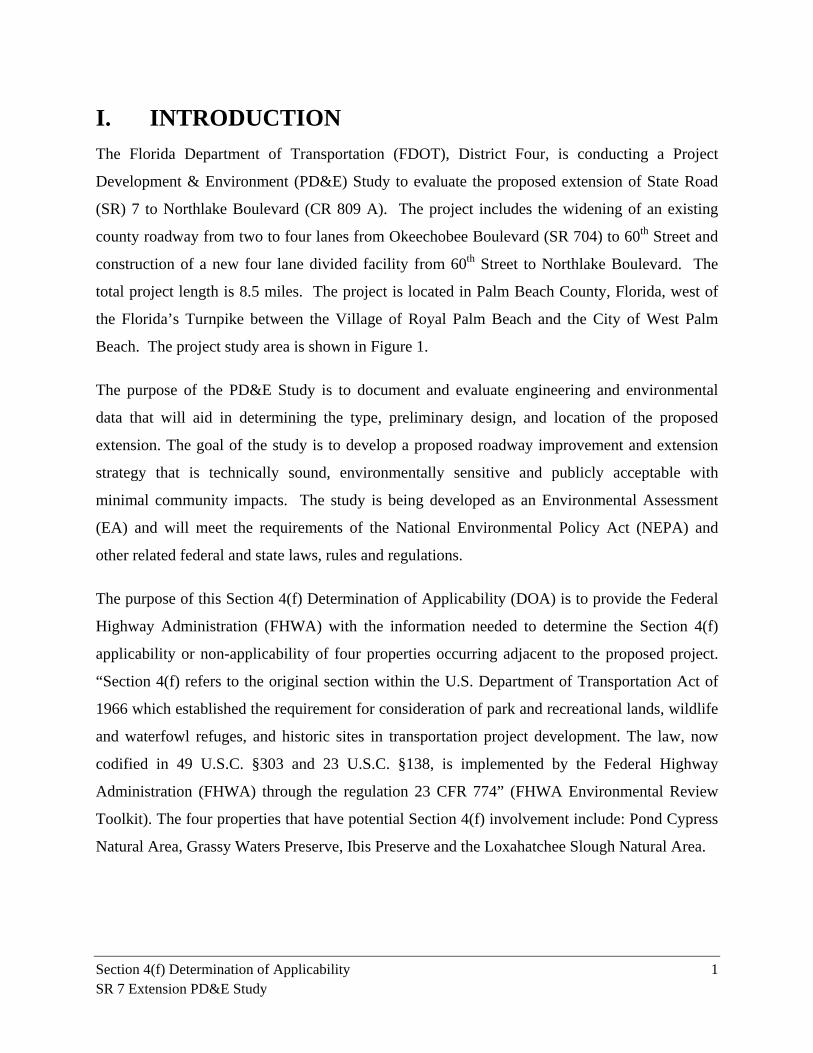
Beach. The project study area is shown in Figure 1.
The purpose of the PD&E Study is to document and evaluate engineering and environmental
data that will aid in determining the type, preliminary design, and location of the proposed
extension. The goal of the study is to develop a proposed roadway improvement and extension
strategy that is technically sound, environmentally sensitive and publicly acceptable with
minimal community impacts. The study is being developed as an Environmental Assessment
(EA) and will meet the requirements of the National Environmental Policy Act (NEPA) and
other related federal and state laws, rules and regulations.
The purpose of this Section 4(f) Determination of Applicability (DOA) is to provide the Federal
Highway Administration (FHWA) with the information needed to determine the Section 4(f)
applicability or non-applicability of four properties occurring adjacent to the proposed project.
“Section 4(f) refers to the original section within the U.S. Department of Transportation Act of
1966 which established the requirement for consideration of park and recreational lands, wildlife
and waterfowl refuges, and historic sites in transportation project development. The law, now
codified in 49 U.S.C. §303 and 23 U.S.C. §138, is implemented by the Federal Highway
Administration (FHWA) through the regulation 23 CFR 774” (FHWA Environmental Review
Toolkit). The four properties that have potential Section 4(f) involvement include: Pond Cypress
Natural Area, Grassy Waters Preserve, Ibis Preserve and the Loxahatchee Slough Natural Area.
LoxahatcheeSlough
PondCypressNatural
Area
Village of RoyalPalm Beach
Okeechobee Blvd. (SR 704)
Bee Line Hwy. (SR 710)
Begin Project
Orange Blvd.
Persimmon Blvd.
Roya
l Palm
Bea
ch B
lvd.
M-Canal60th St. N
The Acreage
End Project
Existing Palm BeachCounty R/W
Ibis Golf& Country
Club
IbisPreserve
110th
Ave.
N
Northlake Blvd.
Grassy Waters Preserve
PGA Blvd.
Florid
a's Tu
rnpik
e
Southern Blvd. (SR 80)
State
Roa
d 7
SR 7 Extension PD&E StudyStudy Area
Figure 1
¹
FM# 229664-2-22-01
LegendProposed SR 7 AlignmentIbis PreserveGrassy Waters Preserve
Loxahatchee SloughPond Cypress Natural Area
Section 4(f) Determination of Applicability 3 SR 7 Extension PD&E Study
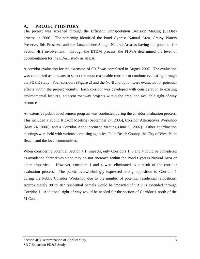
A. PROJECT HISTORY The project was screened through the Efficient Transportation Decision Making (ETDM)
process in 2006. The screening identified the Pond Cypress Natural Area, Grassy Waters
Preserve, Ibis Preserve, and the Loxahatchee Slough Natural Area as having the potential for
Section 4(f) involvement. Through the ETDM process, the FHWA determined the level of
documentation for the PD&E study as an EA.
A corridor evaluation for the extension of SR 7 was completed in August 2007. The evaluation
was conducted as a means to select the most reasonable corridor to continue evaluating through
the PD&E study. Four corridors (Figure 2) and the No-Build option were evaluated for potential
effects within the project vicinity. Each corridor was developed with consideration to existing
environmental features, adjacent roadway projects within the area, and available right-of-way
resources.
An extensive public involvement program was conducted during the corridor evaluation process.
This included a Public Kickoff Meeting (September 27, 2005), Corridor Alternatives Workshop
(May 24, 2006), and a Corridor Announcement Meeting (June 5, 2007). Other coordination
meetings were held with various permitting agencies, Palm Beach County, the City of West Palm
Beach, and the local communities.
When considering potential Section 4(f) impacts, only Corridors 1, 3 and 4 could be considered
as avoidance alternatives since they do not encroach within the Pond Cypress Natural Area or
other properties. However, corridors 1 and 4 were eliminated as a result of the corridor
evaluation process. The public overwhelmingly expressed strong opposition to Corridor 1
during the Public Corridor Workshop due to the number of potential residential relocations.
Approximately 90 to 107 residential parcels would be impacted if SR 7 is extended through
Corridor 1. Additional right-of-way would be needed for the section of Corridor 1 north of the
M-Canal.
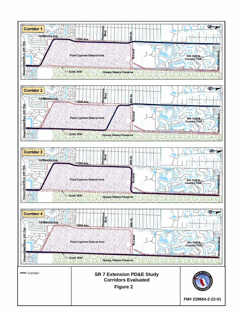
SR 7 Extension PD&E StudyCorridors Evaluated
Figure 2
FM# 229664-2-22-01
Corridor
Section 4(f) Determination of Applicability 5 SR 7 Extension PD&E Study
Lack of support for Corridor 4, commonly referred to as the “Range Line” alignment, was
expressed by the permitting agencies during an agency workshop and during coordination
meetings with the South Florida Water Management District (SFWMD) and the U.S. Army
Corps of Engineers (USACE). Furthermore, the U.S. Fish and Wildlife Service (USFWS)
assigned a degree of effect of “dispute resolution” under the special designation (related to public
conservation lands), wetlands, and wildlife and habitat categories in its response to the ETDM
process. Assigning a category as “dispute resolution” typically signifies that the project (or in
this case, the corridor) does not conform to statutory requirements. The agencies were concerned
that a road along Corridor 4 would fragment the wildlife habitat between the Pond Cypress
Natural Area from the Grassy Waters Preserve. The FDOT will retain ownership of the right-of-
way within the Range Line until a decision has been made regarding the SR 7 PD&E Study.
After examining the conditions involved with constructing either Corridors 1, 2, or 4, it was
determined that none of those options would likely receive approval beyond the Public Hearing.
It was determined that Corridor 3 balanced the concerns and desires of the public and permitting
agencies. For this reason, the FDOT recommended to further develop Corridor 3 and carry
forward this corridor and the No-Build option through the Public Hearing. On April 2, 2007, the
FHWA conceptually concurred with this recommendation. In addition, the FHWA determined
that the level of documentation for the PD&E Study of Corridor 3 and the No-Build option
would be an EA.
There are two proposed options for crossing the M-Canal within Corridor 3. The first option
includes a skewed bridge crossing over the M-Canal. This option avoids any encroachment
within the boundaries of the Pond Cypress Natural Area but results in a portion of the bridge
being located within a section of the M-Canal which is owned by the City of West Palm Beach.
The City requires a license agreement for any new bridge crossings over the M-Canal within its
right-of-way.
A second option for crossing the canal was created to fit the bridge within the existing FDOT
right-of-way. However, the alignment of the proposed roadway must shift south into the Pond
Cypress Natural Area to maintain the bridge within the limits of the FDOT right-of-way. The
curve along the alignment leading up to the bridge would be super-elevated at 4.5 percent. The
Section 4(f) Determination of Applicability 6 SR 7 Extension PD&E Study
end result is a bridge crossing that is geometrically desirably and better aligned with the canal.
The total acreage of the Pond Cypress Natural Area is 1,736.58 acres. The amount of
encroachment into the area for this alignment is approximately 7.29 acres, or 0.42% of the total
property area.
B. PROJECT DESCRIPTION This project proposes to extend SR 7 up to Northlake Boulevard in Palm Beach County, Florida
(Figure 1). The project includes the widening of an existing county roadway from two to four
lanes, from Okeechobee Boulevard to 60th Street, and construction of a new four lane divided
facility from 60th Street to Northlake Boulevard.
In 2009, Palm Beach County completed a two-lane undivided extension of SR 7 from
Okeechobee Boulevard to Persimmon Boulevard for a distance of 3.5 miles. This existing
facility includes a 10-foot wide shoulder along the east side and a 5-foot wide shoulder along the
west side. A 6-foot wide sidewalk is provided along the east side and a fence separates the road
right-of-way and Pond Cypress Natural Area. The existing right-of-way varies between 185 to
360 feet and can accommodate a future four lane expansion. There is one signalized intersection
at Okeechobee Boulevard. The non-signalized intersections include the entrance to Porto Sol,
Orange Grove Boulevard, and Persimmon Boulevard. The county is planning to extend this two
lane facility by one mile up to 60th Street.
The SR 7 extension project would follow the county’s two lane alignment and continue beyond
60th Street to Northlake Boulevard. Proposed improvements under this project include the
widening of the existing county facility from two to four lanes from Okeechobee Boulevard to
60th Street and construction of a new four lane facility from 60th Street to Northlake Boulevard.
Proposed roadway features would include a 42-foot wide raised median, 4-foot wide bicycle
lanes, standard curb and gutter, and 6-foot wide sidewalk. The project will be constructed within
FDOT or county-owned right-of-way. There is one proposed bridge structure for the crossing
over the M-Canal.
Section 4(f) Determination of Applicability 7 SR 7 Extension PD&E Study
II. PURPOSE AND NEED STATEMENT
This project has been identified as a priority within the Palm Beach Metropolitan Planning
Organization’s (MPO) 2035 Long Range Transportation Plan (LRTP). The purpose of the
project is to improve system linkage within the western fringes of urbanized Palm Beach County
and provide additional capacity to ease the congestion experienced within the area defined by the
Village of Royal Palm Beach and The Acreage communities. This project is needed because: (1)
there is a clear necessity to improve system linkage between Okeechobee Boulevard and
Northlake Boulevard; (2) the Palm Beach MPO has identified this project as a critical priority;
and (3) travel demands within western Palm Beach County will continue to grow.
System Linkage and Connectivity
As one of four major arterial facilities connecting Miami-Dade, Broward, and Palm Beach
Counties, SR 7 is a critical inter-regional component of south Florida’s transportation network.
Other facilities, listed in order from west to east, include the Florida’s Turnpike, I-95, and US 1.
Travel demands within the project area will continue to grow and connecting SR 7 with
Northlake Boulevard is vital to satisfying capacity and mobility needs. The proposed
improvement would be usable and beneficial to the surrounding network and could function
without the need for additional improvement. Although the intersection at Okeechobee
Boulevard is projected to exceed capacity prior to the 2040 design year, this condition would
occur even for the No-Build scenario. The connection up to Northlake Boulevard is expected to
operate acceptably meeting the requirements for independent utility.
The proposed extension of SR 7 will facilitate the hurricane evacuation process by providing
additional capacity and connectivity in this area. Okeechobee Boulevard is an east-west facility
that is classified as Urban Other Principal Arterial. It provides connectivity between Seminole
Pratt Whitney Road, SR 7, Florida’s Turnpike, Interstate 95 (I-95), US-1, and downtown West
Palm Beach. Northlake Boulevard is classified as an Urban Minor Arterial that transverses
across the county in an east-west direction while providing connectivity to SR 710 (Beeline
Highway) and I-95. In addition to the extension of SR 7, the Palm Beach MPO has identified the
need to widen Northlake Boulevard, from four to six lanes, within the Cost Feasible Plan of the
2035 LRTP.
Section 4(f) Determination of Applicability 8 SR 7 Extension PD&E Study
Federal, State or Local Mandate
On June 17, 2004, the Palm Beach MPO filed a motion to direct FDOT to begin a PD&E study
for extending SR 7 beyond Okeechobee Boulevard. The motion was carried unanimously.
Traffic demand associated with future developments within the area indicated a need for
extending SR 7 to relieve congestion within the western portions of the county. The limits of the
project, from Okeechobee Boulevard to Northlake Boulevard, were established during the next
meeting on July 15, 2004. The project was added to the Tentative Fiscal Year (FY) 2006-10
Transportation System Priorities list and presented to the MPO Board on October 21, 2004 for
approval. The project list was then transmitted to the FDOT, District Four, for inclusion in its
Work Program. The proposed extension of SR 7 is consistent with the Palm Beach County
Comprehensive Plan (Transportation Element, Policy 1.4-m) and has been identified as a priority
within the Palm Beach MPO's Year 2035 LRTP, Cost Feasible Plan.
Transportation Demand
Current and future development growth in Palm Beach County is primarily located west of the
project study area. At one time, over 14,000 residential units were proposed within areas
surrounding the project corridor. Those proposed developments have been canceled since the
start of the study due to recent economic conditions. However, the traffic analysis prepared for
this study maintains the need for a four lane divided facility even with lower growth and
population estimates.
Existing bus services provided by Palm Tran near the project area is limited to Route 52, the
Royal Palm Beach Crosstown route. This route loops between Okeechobee Boulevard, SR 7,
Southern Boulevard, and Royal Palm Beach Boulevard. The Palm Beach MPO has identified in
the 2035 LRTP the need for bicycle and pedestrian facilities within the future extension of SR 7.
These features will also be provided per FDOT policies.
Section 4(f) Determination of Applicability 9 SR 7 Extension PD&E Study
III. ALTERNATIVES CONSIDERED
A. NO-BUILD ALTERNATIVE
Under the No-Build option, future traffic conditions for the surrounding roadway network, as
identified in the 2035 LRTP, are analyzed with the assumption that the proposed improvement is
not in place. These traffic projections provide a benchmark for comparative purposes with the
other Build options. The proposed improvements identified in the 2035 Cost Feasible Plan
include the following:
Widening of Northlake Boulevard from 4 lanes to 6 lanes
Improving 60th Street and widening it to 3 lanes
Advantages of the No-Build option include the following:
No impacts to the wetlands
No environmental degradation or disruption of natural resources
No additional noise impacts
Disadvantages of the No-Build option include the following:
No relief to the increasing traffic demands in the area
No new access to Northlake Boulevard
Is not consistent with the Palm Beach County Comprehensive Plan
Is not consistent with the Palm Beach MPO 2035 LRTP
Will not facilitate the hurricane evacuation process
B. TRANSPORTATION SYSTEMS MANAGEMENT
The Transportation Systems Management (TSM) Alternative includes those types of activities
designed to maximize the use of the existing transportation system. It is a limited construction
alternative that uses minor improvements to address the deficiencies identified by the project
need. Proposed improvements include the widening of Persimmon Boulevard from Royal Palm
Boulevard to SR 7, widening of Northlake Boulevard from Seminole Pratt Whitney Road to
Section 4(f) Determination of Applicability 10 SR 7 Extension PD&E Study
Coconut Boulevard, widening of Seminole Pratt Whitney Road from Persimmon Boulevard to
Northlake Boulevard, and the widening of 60th Street from Royal Palm Boulevard to SR 7.
Because the primary purpose of the project is to provide system linkage between Okeechobee
Boulevard and Northlake Boulevard, a TSM alternative was not evaluated for this project. Only
the Build or No-Build options were considered.
C. BUILD ALTERNATIVES
For the purpose of describing the Build Alternatives, the project is divided into two segments.
The first segment extends from Okeechobee Boulevard to the intersection at 60th Street and the
second segment continues from the intersection at 60th Street up to Northlake Boulevard. Within
the first segment, the project includes the widening of the county’s existing facility from two to
four lanes. A new four lane divided facility is proposed within the second segment. Various
intersection options are proposed throughout the project including locations at Okeechobee
Boulevard, 60th Street, and the entrance to the Ibis community. Two options for the crossing
over the M-Canal are also proposed. Additional detail is provided in the sections below.
Figures depicting each alternative are provided in Appendix A.
C-1. SEGMENT 1
Segment 1 extends from Okeechobee Boulevard to 60th Street. The available right-of-way
within this segment of the project corridor varies from 185 to 360 feet and is located along the
western boundary of the Pond Cypress Natural Area. Within this segment, only one Build
Alternative is proposed. This Alternative includes the widening of the county’s existing roadway
from two lanes undivided to four lanes divided. The additional two lanes will be constructed
along the west side of the existing facility, separated by a 42-foot wide median. The existing
drainage system consists of a 50-foot wide dry swale parallel to the roadway and one retention
pond. No additional drainage facilities or pond sites are proposed within this segment.
C-2. SEGMENT 2
Segment 2 extends from 60th Street to Northlake Boulevard where a new four lane divided
facility is proposed. The available right-of-way along the south bank of the M-Canal varies
between 78 to 367 feet and the right-of-way north of the M-Canal varies between 200 to 320
feet. Three Build Alternatives are proposed within Segment 2 and are identified as the West,
Section 4(f) Determination of Applicability 11 SR 7 Extension PD&E Study
Center, and East Alignment Alternatives.
West Alignment Alternative
From 60th Street, the alignment proceeds along the south bank of M-Canal as a new four lane
divided facility. At the point where the FDOT’s right-of-way crosses over the M-Canal, the
alignment turns north to cross over the M-Canal and continues along the west side of the existing
right-of-way located between the Ibis Golf and Country Club and the Grassy Waters Preserve
(also known as the Water Catchment Area). A linear retention swale and linear pond would be
located within the right-of-way between the proposed roadway and the western limit of the
Grassy Waters Preserve. Standard features incorporated into the proposed typical section
include 12-foot wide lanes, a raised median, curb and gutter, 4-foot wide bike lanes, and 6-foot
wide sidewalk on both sides.
Center Alignment Alternative
From 60th Street, the alignment proceeds along the south bank of M-Canal as a new four lane
divided facility. At the point where the FDOT’s right-of-way crosses over the M-Canal, the
alignment turns north to cross over the M-Canal and continues within the center of the existing
right-of-way located between the Ibis Golf and Country Club and the Grassy Waters Preserve. A
linear retention swale and linear pond would be located along both sides of the roadway within
the existing right-of-way. Standard features incorporated into the proposed typical section
include 12-foot wide lanes, a raised median, curb and gutter, 4-foot wide bike lanes, and 6-foot
wide sidewalk on both sides.
East Alignment Alternative
From 60th Street, the alignment proceeds along the south bank of M-Canal as a new four lane
divided facility. At the point where the FDOT’s right-of-way crosses over the M-Canal, the
alignment turns north to cross over the M-Canal and continues along the east side of the existing
right-of-way located between the Ibis Golf and Country Club and the Grassy Waters Preserve. A
linear retention swale and linear pond would be located within the right-of-way between the Ibis
Golf and Country Club and the proposed roadway. Standard features incorporated into the
proposed typical section include 12-foot wide lanes, a raised median, curb and gutter, 4-foot
wide bike lanes, and 6-foot wide sidewalk on both sides.
Section 4(f) Determination of Applicability 12 SR 7 Extension PD&E Study
D. INTERSECTION OPTIONS Two intersection options are proposed at each of the intersections at Okeechobee Boulevard,
60th Street, and at the entrance to the Ibis Golf and Country Club.
D-1. OKEECHOBEE BOULEVARD
Two options are proposed for the intersection at Okeechobee Boulevard and SR 7. These
options include an at-grade intersection and a grade separated interchange.
Under the at-grade intersection option, the existing configuration of the intersection will remain
as follows:
South Leg (SR 7): Three left turn lanes, two through lanes, and two right turn lanes.
North Leg (SR 7): Two left turn lanes, three through lanes, and one right turn lane.
West Leg (Okeechobee Boulevard): Two left turn lanes, four through lanes, and two right
turn lanes.
East Leg (Okeechobee Boulevard): Three left turn lanes, four through lanes, and a single
right turn lane.
Under the grade separated interchange option, the through movement along Okeechobee
Boulevard would be elevated over SR 7. The Okeechobee mainline bridge over SR 7 would
include three 12-foot wide lanes in each direction with 10-foot wide shoulders on each side
separated by a 22-foot wide traffic separator. The eastbound off-ramp would include one
dedicated 12-foot wide left turn lane, a shared 12-foot wide left and through lane, a 5-foot wide
bicycle lane, and three 12-foot wide right turn lanes. The east bound on-ramp would include
three 12-foot wide lanes that ultimately merge into one lane. The westbound off-ramp would
include one dedicated 12-foot wide left turn lane, a shared 12-foot wide left and through lane, a
5-foot wide bicycle lane, and three 12-foot wide right turn lanes. The westbound on-ramp would
include three 12-foot wide lanes that ultimately merge into one lane. The lane configuration
along SR 7 would remain as proposed under the at-grade alternative.
D-2. 60TH STREET
Two options are proposed for the intersection at 60th Street. These options include a roundabout
and a T-intersection under signal control. Both options could be accommodated within the
existing right-of-way.
Section 4(f) Determination of Applicability 13 SR 7 Extension PD&E Study
The roundabout would include two circulating lanes except along the east side of the roundabout
where only one lane is proposed. The conceptual design includes the following characteristics:
Approximately 220-foot wide inscribed circle diameter;
Truck apron with varying width from 6 to 15 feet;
Two 15-foot wide approach lanes on all approaches;
15-foot wide circulating lanes on the north and south sides;
18-foot wide circulating lane along the east side; and
18-foot wide circulating outside lane along the west side.
Under the T-intersection option, the proposed configuration would include the following:
South Leg (SR 7): One left turn lane and two right turn lanes.
West Leg (60th St): One through lane and one right turn lane.
East Leg (SR 7): Two left turn lanes and a single right turn lane.
D-3. IBIS ENTRANCE
Two options are proposed for the intersection at the entrance to the Ibis Golf and Country Club.
These options include a roundabout and a T-intersection under signal control. In general, both
options could be accommodated within the existing right-of-way. However, some encroachment
will be required for the West Alignment Alternative to properly tie into the existing entrance at
Ibis.
The roundabout would include two circulating lanes except along the north side of the
roundabout where only one lane is proposed. The conceptual design includes the following
characteristics:
Approximately 160-foot wide inscribed circle diameter;
6-foot wide truck apron;
Two 15-foot wide approach lanes on all approaches;
Two 15-foot wide circulating lanes with a single 18-foot wide lane on the north side; and
Two 15-foot wide exit lanes on the northbound and southbound movements and one 18-
foot wide exit lane on the westbound movement.
Under the T-intersection option, the proposed configuration would include the following:
South Leg (SR 7): One left turn lane and two through lanes.
Section 4(f) Determination of Applicability 14 SR 7 Extension PD&E Study
North Leg (SR 7): Two through lanes and one right turn lane.
West Leg (Ibis): One left turn lane and one right turn lane.
E. CANAL CROSSING OPTIONS
Two options are proposed for the crossing over the M-Canal. The first option includes a skewed
bridge crossing over the M-Canal. The second option includes a perpendicular bridge crossing
over the M-Canal.
E-1. SKEWED BRIDGE CROSSING
Under this option, a skewed bridge crossing over the M-Canal is proposed. A portion of the
bridge would be located outside of the FDOT right-of-way. However, the benefit of this option
is that it avoids the Pond Cypress Natural Area. As part of the corridor evaluation process, the
straight alignment corridor through the FDOT right-of-way (identified as Corridor 4) was
discarded due to concerns from the permitting agencies. Additional right-of-way is needed to
accommodate the selected corridor.
E-2. STRAIGHT BRIDGE CROSSING
Under this option, a bridge perpendicular to the M-Canal is proposed. The benefit of this option
is that the bridge would be located within FDOT-owned right-of-way across the canal. This
avoids any encroachment over the portion of the M-Canal owned by the City of West Palm
Beach. However, to maintain the bridge within FDOT right-of-way, the alignment must shift
south into the Pond Cypress Natural Area. The curve along the alignment leading up to the
bridge would be super-elevated at 4.5 percent. The amount of encroachment into the Pond
Cypress Natural Area is approximately 7.29 acres.
Section 4(f) Determination of Applicability 15 SR 7 Extension PD&E Study
IV. PUBLIC LANDS ADJACENT TO CORRIDOR
The provisions of Section 4(f) applies to any significant publicly owned public park, recreation
area, or wildlife and waterfowl refuge and any land from an historic site of national, state or local
significance (FHWA, 2005). “Significant” as applied in a Section 4(f) DOA is determined based
on the availability and function of the recreational resource, park, and/or wildlife/waterfowl
refuge area relative to the community objectives for those facilities and the role the site in
question plays in fulfilling those objectives. The agencies that have jurisdiction over these sites
make a significance determination based on the criteria described above and submit Statement of
Significance Letters to the FDOT. Resources are presumed to be significant unless the official
having jurisdiction over the site concludes that the entire site is not significant.
There are no publically owned parks or historic or archeological sites adjacent to the project,
however, there are four recreation facilities and/or, wildlife and waterfowl refuges areas adjacent
to the project that are potential Section 4(f) sites. They are the Pond Cypress Natural Area,
Grassy Waters Preserve, Ibis Preserve, and Loxahatchee Slough Natural Area. Their proximity to
the proposed project is depicted in Figures 3, 5 and 8. A DOA was conducted for these four
publicly owned lands to determine if these properties met the criteria required for protection
under Section 4(f). The following information was evaluated for each site as the basis for the
DOA:
1. A detailed map identifying the relationship of the proposed project alternatives to the
properties,
2. Size and location of the properties,
3. Ownership and type of Section 4(f) property (park, recreation, wildlife refuge, historic),
4. Function or available activities on the properties,
5. Description/location of all existing and planned facilities,
6. Access (pedestrian, vehicular) and usage (approximate number of users/visitors),
7. Relationship to other similarly used lands in the vicinity,
8. Applicable clause affecting ownership, such as lease, easement, covenants, restrictions,
or conditions, including forfeiture,
9. Unusual characteristics of the Section 4(f) properties (flooding, terrain, other features)
that either reduce or enhance the value of all or part of the property,
Section 4(f) Determination of Applicability 16 SR 7 Extension PD&E Study
10. Statement on significance from the official who has jurisdiction over the Section 4(f)
property (regarding the entire property, not of the proposed use),
11. Project activities, which may result in proximity impacts to the resources, and attributes
or features of the Section 4(f) properties, which may be sensitive to proximity impacts
from potential constructive use, and
12. Grants Applicable to Section 4(f) Properties.
The following sections explain each of the four sites in detail.
Section 4(f) Determination of Applicability 17 SR 7 Extension PD&E Study
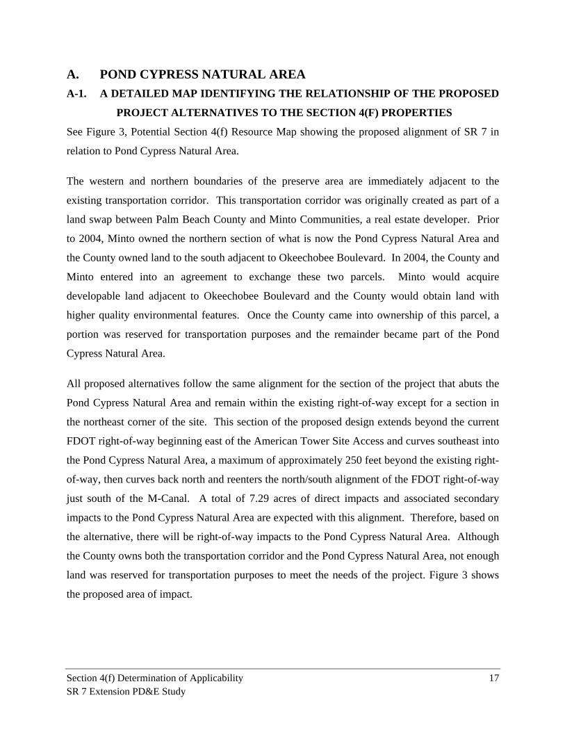
A. POND CYPRESS NATURAL AREA
A-1. A DETAILED MAP IDENTIFYING THE RELATIONSHIP OF THE PROPOSED
PROJECT ALTERNATIVES TO THE SECTION 4(F) PROPERTIES
See Figure 3, Potential Section 4(f) Resource Map showing the proposed alignment of SR 7 in
relation to Pond Cypress Natural Area.
The western and northern boundaries of the preserve area are immediately adjacent to the
existing transportation corridor. This transportation corridor was originally created as part of a
land swap between Palm Beach County and Minto Communities, a real estate developer. Prior
to 2004, Minto owned the northern section of what is now the Pond Cypress Natural Area and
the County owned land to the south adjacent to Okeechobee Boulevard. In 2004, the County and
Minto entered into an agreement to exchange these two parcels. Minto would acquire
developable land adjacent to Okeechobee Boulevard and the County would obtain land with
higher quality environmental features. Once the County came into ownership of this parcel, a
portion was reserved for transportation purposes and the remainder became part of the Pond
Cypress Natural Area.
All proposed alternatives follow the same alignment for the section of the project that abuts the
Pond Cypress Natural Area and remain within the existing right-of-way except for a section in
the northeast corner of the site. This section of the proposed design extends beyond the current
FDOT right-of-way beginning east of the American Tower Site Access and curves southeast into
the Pond Cypress Natural Area, a maximum of approximately 250 feet beyond the existing right-
of-way, then curves back north and reenters the north/south alignment of the FDOT right-of-way
just south of the M-Canal. A total of 7.29 acres of direct impacts and associated secondary
impacts to the Pond Cypress Natural Area are expected with this alignment. Therefore, based on
the alternative, there will be right-of-way impacts to the Pond Cypress Natural Area. Although
the County owns both the transportation corridor and the Pond Cypress Natural Area, not enough
land was reserved for transportation purposes to meet the needs of the project. Figure 3 shows
the proposed area of impact.
Mang
o Blvd
.
Roya
l Palm
Bea
ch B
lvd.
SR 7
110th
Ave.
N
Pond CypressNatural Area
Grassy Waters Preserve
Existing Palm Beach County R/W reserved fortransportation purposes
Existing FDOT R/W
Area of Encroachment
M-Canal60th St. N
Sunset Blvd.
Persimmon Blvd.
Orange Grove Blvd.
Okeechobee Blvd. (SR 704)
Village of RoyalPalm Beach
The Acreage
Begin Project
SR 7 Extension PD&E StudyPond Cypress Natural Area
Figure 3
¹
FM# 229664-2-22-010 1,300 2,600 3,900 5,200
Feet1 inch = 2,600 feet
LegendProposed R/W
Existing R/W
Proposed widening, 2 to 4 lanes
Grassy Waters Preserve
Pond Cypress Natural Area
American Tower Parcel
Proposed new 4-lane construction
Section 4(f) Determination of Applicability 19 SR 7 Extension PD&E Study
A-2. SIZE AND LOCATION OF THE AFFECTED SECTION 4(F) PROPERTIES
The size of the Pond Cypress Natural Area is 1,736 acres (702.83 hectares). The Pond Cypress
Natural Area is located in the east central portion of Palm Beach County in Sections 1, 12, 13,
and 24, Township 43 South and Range 41 East. It is west of the City of Palm Beach and
northeast east of the Village of Royal Palm Beach. The area is bordered on the north by the M-
Canal, on the south by the new SR 7 extension, on the west side by 110 Avenue North and on the
east by the Grassy Waters Preserve. The property is physically severed from the Grassy Waters
Preserve by a canal and berm that run the length of the property.
A-3. OWNERSHIP AND TYPE OF SECTION 4(F) PROPERTY
Palm Beach County owns the Pond Cypress Natural Area (PCNA). The Palm Beach County
Department of Environmental Resource Management (ERM) manages the property as a publicly
owned preserve with the primary purpose of conserving and improving the high quality wetland
and associated upland habitat together with their component protected species. It will also be
managed as a natural resource based, passive outdoor recreational site with educational and
research opportunities (Appendix B - PCNA Management Plan, 2010).
A-4. FUNCTION OR AVAILABLE ACTIVITIES ON THE PROPERTIES
The Pond Cypress Natural Area contains a western bulge of the historic Loxahatchee Slough,
while the rest of the site contains buffer lands and tributary drainage ways that historically
connected by sheet flow eastwards to the slough. It contains a high quality mosaic of mesic
flatwoods, wet prairie, strand swamp, depression marsh, prairie hammock, and dome swamp
plant communities and provides foraging and potential breeding habitat for the Everglades snail
kite (Rostrhamus sociabilis plumbeus) which is a very rare animal species in the Palm Beach
County Natural Areas System and is listed as endangered by the US Fish and Wildlife Service
(USFWS) and the Florida Fish and Wildlife Conservation Commission (FFWCC). Other
endangered and threatened animal species documented on the site include the American alligator
(Alligator mississippiensis), Eastern indigo snake (Drymarchon couperi), (Audubon’s crested
caracara (Caracara cheriway), Florida Scrub Jay (Aphelocoma coerulescens), Florida sand hill
crane (Grus canadensis pratensis), wood stork (Mycteria americana) and least tern (Sterna
antillarum). Additionally, Section 1 (Appendix B – Pond Cypress Natural Area Management
Plan, Appendix D, Exhibit A) of the Pond Cypress Natural Area was used for mitigation for the
Section 4(f) Determination of Applicability 20 SR 7 Extension PD&E Study
SR 7 extension (reliever road). The mitigation included preservation and hydrologic restoration
by controlling the water flow and prolonging the hydroperiod in the site to more accurately.
depict historic conditions.
A-5. DESCRIPTION/LOCATION OF ALL EXISTING AND PLANNED FACILITIES
Existing facilities consist of historic roads and trails that were present at the time of acquisition
of the site by the county (Figure 4).
The Pond Cypress Natural Area management plan was completed in July of 2010 and includes
both habitat restoration and the construction of passive use recreational facilities as planned
improvements for this natural area. Recreational improvements include the construction of
management roads, trails, an educational kiosk and parking facility.
The recreational improvements will be implemented over time based on available funding
according to Jeff Buck, the Palm Beach County Department of ERM Land Manager for Pond
Cypress Natural Area. Mr. Buck also provided an implementation sequence for the development
of the facilities. He indicated that the construction of the management roads began in April
2011. A 1,435- foot long paved nature trail will be constructed as an interpretive feature and
will provide Americans with Disabilities Act compliant access to portions of the area. In
addition, approximately 5.7 mile of unimproved natural surface hiking trails will be provided on
site. A parking facility that will accommodate 10 cars and a bus is proposed across from Orange
Grove Boulevard. A bicycle rack and educational kiosk will be constructed adjacent to the
parking area near the entrance to the trail. Informational trail markers will be installed along the
interpretive trail and a trail guide for the entire facility will be developed once construction nears
completion. The proposed extension of SR 7 would not impact these planned facilities.
A-6. ACCESS AND USAGE
A portion of the Pond Cypress Natural Area is fenced. Approximately 13,000 feet of 10-foot-tall
green chain-link fence has been installed along the south and west boundary of the natural area
as part of the SR 7 extension project. A wire field fence extends along the east side of 110th
Avenue North, approximately 360 feet west of the natural area boundary. The north and east
sides of the natural area currently are not fenced and ERM has no plans to fence the rest of the
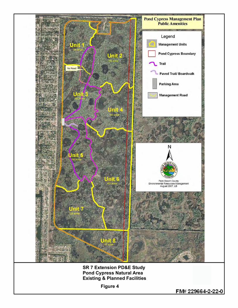
SR 7 Extension PD&E StudyPond Cypress Natural AreaExisting & Planned Facilities
Figure 4
Section 4(f) Determination of Applicability 22 SR 7 Extension PD&E Study
natural area at this time, however fences and gates will be added to restrict vehicular access to
the site, once the management roads are complete. Access for hiking, bird watching, nature
photography and other passive recreation uses is allowed and encouraged by the ERM.
The site is currently accessed by the public based on information received from the ERM;
however, no mechanism is in place to quantify the number of user visits at this time.
A-7. RELATIONSHIP TO OTHER SIMILARLY USED LANDS IN THE VICINITY
The Pond Cypress Natural Area is adjacent to the Grassy Waters Preserve Water Catchment
Area to the east. This adjacency benefits the natural communities within both properties by
providing connected wildlife habitat and by buffering the native vegetation communities from
development over at least a portion of each site’s boundaries. In addition, the City of West Palm
has agreed to allow the county to connect to the trails in the Grassy Waters Preserve to expand
the trails network on these two adjoining preservation lands. The site is also in direct proximity
to two other City-owned preserves. The 366-acre Ibis Golf and Country Club wetland preserve,
is located just north of the M-Canal and the 274-acre Baywinds Preserve, which is located
adjacent to the southeastern corner of the natural area. In addition, the Comprehensive
Everglades Restoration Plan, Master Recreation Plan (2009) included the area was in as a
partnering consideration for the C-51 Stormwater Treatment Area recreation plans citing existing
and planned passive use recreational opportunities at the site.
A-8. APPLICABLE CLAUSE AFFECTING THE OWNERSHIP
Two easements exist on the Pond Cypress Natural Area:
Florida Power and Light has a utility easement for high voltage transmission lines.
Palm Beach County granted a conservation easement over the site to the South Florida
Water Management District on September 9, 2008 as partial mitigation required for the
construction of Acreage Reliever Road. (PCMA, Management Plan, Appendix B).
A-9. UNUSUAL CHARACTERISTICS
The area contains a western bulge of the historic Loxahatchee Slough, which serves as the
headwaters for the Wild and Scenic Designated Loxahatchee River and is a regionally significant
wetland according to Palm Beach County ERM. These features enhance the value of the
property.
Section 4(f) Determination of Applicability 23 SR 7 Extension PD&E Study
A-10. STATEMENT OF SIGNIFICANCE
On March 27, 2009, the FDOT received a letter from Palm Beach County Department of
Environmental Resources Management stating the significance of the Pond Cypress Natural
Area. The letter states that the Pond Cypress Natural Area is a significant resource to the
wildlife preservation and passive recreational opportunities in Palm Beach County. A copy of
this letter is provided within Appendix B.
A-11. CONSTRUCTIVE USE / PROXIMITY IMPACTS
The only direct impacts to Pond Cypress Natural Area are related to the Option E-2 crossing of
the M-Canal. Under this option, a bridge perpendicular to the M-Canal is proposed. However,
to maintain the bridge within FDOT right-of-way, the alignment must shift south, requiring
additional right-of-way within the northeastern corner of the natural area. This will result in
temporary and permanent, direct and secondary impacts to freshwater marsh and hydric pine
wetland habitats. A quantitative and qualitative wetland assessment has been completed as
support documentation included in the Wetlands Evaluation Report prepared for this PD&E
study.
No direct impacts to the Pond Cypress Natural Area would result from skewed bridge crossing of
the M-Canal as described previously as Option E-1. Direct wetland impacts associated with
construction of the straight bridge crossing of the M-Canal equal 8.02 acres (0.73 acres within
the existing right-of-way and 7.29 acres within the proposed encroachment area needed for the
new right-of-way). Secondary wetland impacts were calculated within a 300-foot buffer of the
direct wetland impacts occurring within the existing right-of-way. Secondary wetland impacts
associated with the project within the Pond Cypress Natural Area equal 8.54 acres.
Approximately 8.40 acres of additional secondary impact would result from the construction of
the straight bridge crossing of the M-Canal. Coordination regarding appropriate mitigation is
ongoing with the South Florida Water Management District and the US Army Corps of
Engineers.
An Endangered Species Biological Assessment (ESBA) has been completed as support
documentation for this PD&E study. Based upon the preliminary results of the ESBA the
proposed project is not likely to adversely affect the existence of any threatened or endangered
Section 4(f) Determination of Applicability 24 SR 7 Extension PD&E Study
species known to occur within or adjacent to this project. The following effect determinations
are likely to apply to the federally listed species:
Wood Stork – “may affect”
American alligator – “may affect, but not likely to adversely affect”
Eastern indigo snake – “may affect, but not likely to adversely affect”
Everglades snail kite – “may affect, but not likely to adversely affect”
Audubon’s crested caracara – “no effect”
Florida scrub jay – “no effect”
Red-cockaded woodpecker – “no effect”
Preconstruction commitments being considered by the FDOT include conducting preconstruction
nest surveys for the Everglades snail kite, Florida sand hill crane and the wood stork, and
adherence to standard FDOT construction precautions for the aforementioned species as well as
the eastern indigo snake. The FDOT will continue to coordinate with the USFWS and the
FFWCC during design and construction phases of the project to ensure that no impact to
endangered and threatened species occur as a result of project activities.
Prescribed burns are included in the management plan for this facility. The proximity of the road
to the site will restrict the conditions when a burn can be conducted, since winds from the east,
north or south could blow smoke onto the road, creating hazardous driving conditions. However,
the county will still be able to implement this management technique under appropriate wind
conditions.
A-12. GRANTS APPLICABLE TO SECTION 4(F) PROPERTIES
There are no grants currently associated with this facility (personal communication, Dave
Jillings, Manager, Palm Beach County ERM); however, future grants may be acquired for
invasive species management.
Section 4(f) Determination of Applicability 25 SR 7 Extension PD&E Study
B. GRASSY WATERS PRESERVE
B-1. A DETAILED MAP IDENTIFYING THE RELATIONSHIP OF THE PROPOSED
PROJECT ALTERNATIVES TO THE SECTION 4(F) PROPERTIES
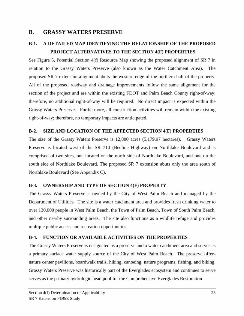
See Figure 5, Potential Section 4(f) Resource Map showing the proposed alignment of SR 7 in
relation to the Grassy Waters Preserve (also known as the Water Catchment Area). The
proposed SR 7 extension alignment abuts the western edge of the northern half of the property.
All of the proposed roadway and drainage improvements follow the same alignment for the
section of the project and are within the existing FDOT and Palm Beach County right-of-way;
therefore, no additional right-of-way will be required. No direct impact is expected within the
Grassy Waters Preserve. Furthermore, all construction activities will remain within the existing
right-of-way; therefore, no temporary impacts are anticipated.
B-2. SIZE AND LOCATION OF THE AFFECTED SECTION 4(F) PROPERTIES
The size of the Grassy Waters Preserve is 12,800 acres (5,179.97 hectares). Grassy Waters
Preserve is located west of the SR 710 (Beeline Highway) on Northlake Boulevard and is
comprised of two sites, one located on the north side of Northlake Boulevard, and one on the
south side of Northlake Boulevard. The proposed SR 7 extension abuts only the area south of
Northlake Boulevard (See Appendix C).
B-3. OWNERSHIP AND TYPE OF SECTION 4(F) PROPERTY
The Grassy Waters Preserve is owned by the City of West Palm Beach and managed by the
Department of Utilities. The site is a water catchment area and provides fresh drinking water to
over 130,000 people in West Palm Beach, the Town of Palm Beach, Town of South Palm Beach,
and other nearby surrounding areas. The site also functions as a wildlife refuge and provides
multiple public access and recreation opportunities.
B-4. FUNCTION OR AVAILABLE ACTIVITIES ON THE PROPERTIES
The Grassy Waters Preserve is designated as a preserve and a water catchment area and serves as
a primary surface water supply source of the City of West Palm Beach. The preserve offers
nature center pavilions, boardwalk trails, hiking, canoeing, nature programs, fishing, and biking.
Grassy Waters Preserve was historically part of the Everglades ecosystem and continues to serve
serves as the primary hydrologic head pool for the Comprehensive Everglades Restoration
M-Canal60th St. N
The Acreage
End Project
Existing Palm BeachCounty R/W
Existing FDOT R/W
Grassy Waters Preserve
Ibis Golf & Country Club
Ibis Preserve
110th
Ave.
N
Existing Palm BeachCounty R/W reserved fortransportation purposes
Northlake Blvd.
SR 7 Extension PD&E StudyGrassy Waters Preserve &
Ibis PreserveFigure 5
¹
FM# 229664-2-22-010 1,000 2,000 3,000 4,000
Feet
1 inch = 2,000 feet
LegendProposed R/W
Existing R/W
Proposed widening, 2 to 4 lanes
Ibis Preserve
Grassy Waters Preserve
American Tower Parcel
Proposed new 4-lane construction
Wetland Preservation
Area 2
Wetland Preservation
Area 1
Wetland Mitigation Area
Wetland Mitigation Area
Section 4(f) Determination of Applicability 27 SR 7 Extension PD&E Study
Program (CERP) FLOW-WAY 1 initiative.
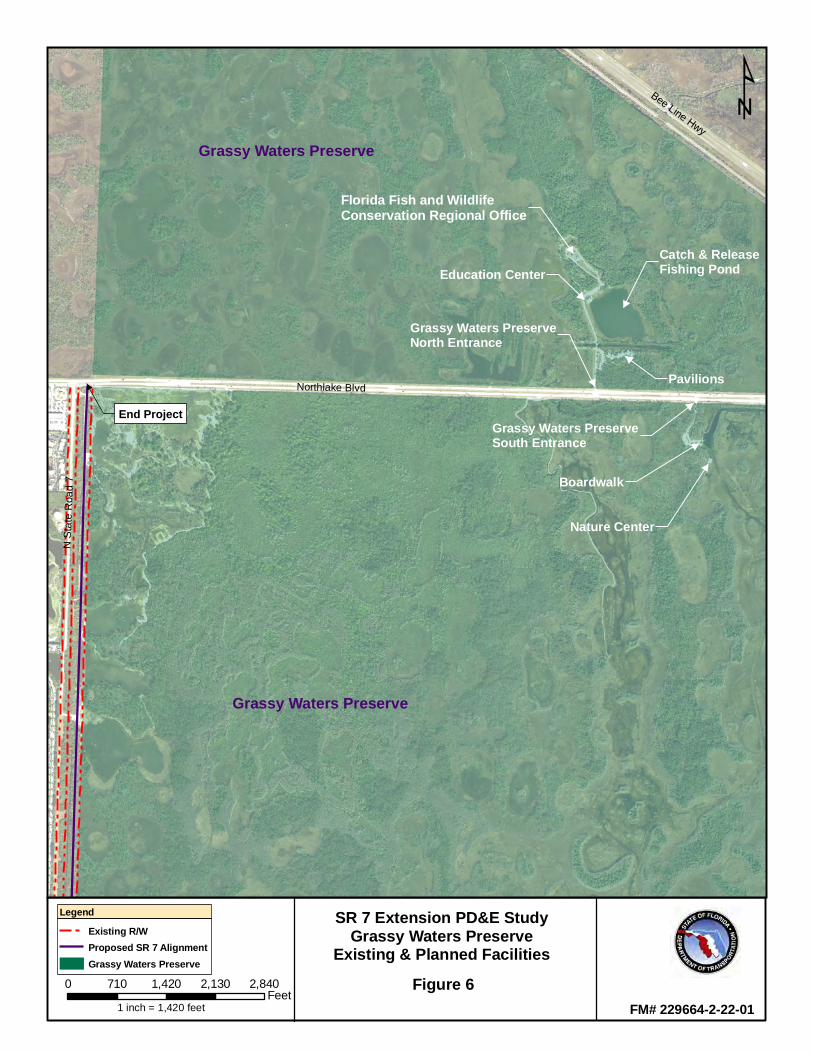
B-5. DESCRIPTION/LOCATION OF ALL EXISTING AND PLANNED FACILITIES
On the south side of Northlake Boulevard, there is a nature center with parking and 1,500 feet of
boardwalk. On the north side of Northlake Boulevard, there are several buildings with parking,
including a nature center and the regional offices of the FFWCC. The north side offers hiking
trails and a lake where catch-and-release fishing is permitted. See Figure 6 for facility locations
within the property. The proposed extension of SR 7 would not impact these existing facilities.
Construction of a new 2-mile hiking and biking trail, the Hog Hammock Trail (on the north side)
is anticipated to be complete in 2011 and there are plans for the expansion of boardwalks and
overlooks (on the south side). Long range plans to connect this area of the county wide blue-
ways system and hiking/biking trails in the adjacent Pond Cypress Natural Area are in
development. The proposed extension of SR 7 would not impact these planed facilities.
B-6. ACCESS AND USAGE
Access to Grassy Waters Preserve is provided through two vehicular access points: the main
entrance is on the south side of Northlake Boulevard just west of SR 710 and on the north side of
Northlake Boulevard ¼ mile west of the Main Entrance off of Northlake Boulevard. The City of
West Palm Beach estimates that based on participation in environmental education and
recreational activities, usage numbers for the preserve are estimated at over 45,000 people per
year. This figure will be expected to increase with the recent opening of the Hog Hammock Trail
(on the north side) and the expansion of boardwalks and overlooks (on the south side). The
proposed extension of SR 7 would not impact these access points.
B-7. RELATIONSHIP TO OTHER SIMILARLY USED LANDS IN THE VICINITY
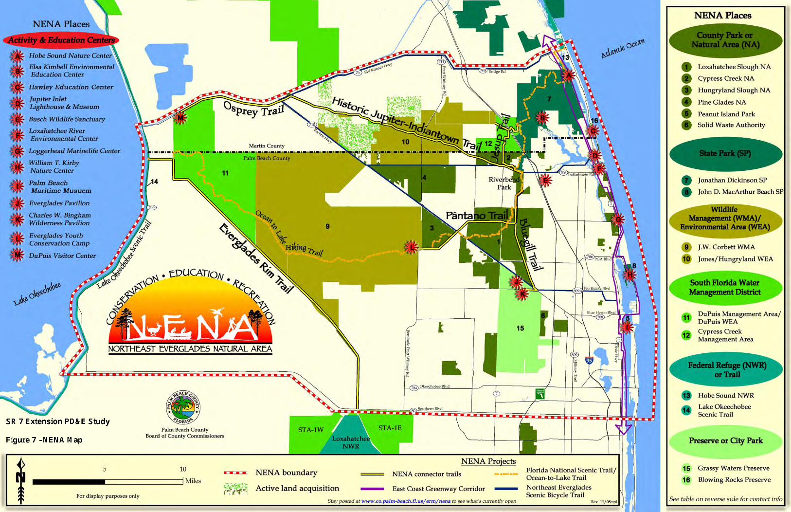
The Northeast Everglades Natural Area (NENA) program is a network of conservation lands
owned by a variety of agencies and managed by Palm Beach County ERM for the purpose of
developing a trail system that connects managed preservation lands throughout the county (see
Figure 7 - NENA Map). The proposed continuation of Bluegill Trail, part of the NENA trails
network, will connect to Grassy Waters Preserve at Northlake Boulevard to a continuous system
of tails throughout the county. The site is also in direct proximity to two other City-owned
Florida Fish and WildlifeConservation Regional Office
End Project
Grassy Waters Preserve
Grassy Waters Preserve
Catch & ReleaseFishing Pond
Pavilions
Education Center
Grassy Waters PreserveNorth Entrance
Grassy Waters PreserveSouth Entrance
Boardwalk
Nature Center
Northlake Blvd
N S
tate
Roa
d 7
Bee Line Hwy
SR 7 Extension PD&E StudyGrassy Waters Preserve
Existing & Planned FacilitiesFigure 6
¹
FM# 229664-2-22-01
0 710 1,420 2,130 2,840Feet
1 inch = 1,420 feet
LegendExisting R/WProposed SR 7 AlignmentGrassy Waters Preserve
Section 4(f) Determination of Applicability 30 SR 7 Extension PD&E Study
preserves. The 366-acre Ibis Golf and Country Club wetland preserve, is located just north of
the M-Canal and the 274-acre Baywinds Preserve, which is located just south of the site.
B-8. APPLICABLE CLAUSE AFFECTING THE OWNERSHIP
Grassy Waters Preserve was provisioned under a special Act of the State Legislature (est.1959)
and this act governs the legal authority and administration of the preserve for purpose of water
supply augmentation and habitat set aside (See Appendix C). There are no known applicable
clauses affecting the ownership of this resource.
B-9. UNUSUAL CHARACTERISTICS
The Grassy Waters Preserve is designated by the Florida Legislature as a Water Catchment Area.
The prairie and marsh wetlands attract numerous wading birds and water fowl such as the roseate
spoonbill (Platalea ajaja), great blue heron (Ardea herodias), great egret (Ardea alba), limpkin
(Aramus guarauna), wood duck (Aix sponsa) and teal duck (Anas crecca). It offers foraging
habitat for species such as the red-shouldered hawks (Buteo lineatus), osprey (Pandion
haliaetus), American kestrel (Falco sparverius) and bald eagles (Haliaeetus leucocephalus) as
well as foraging and nesting habitat for the Everglades snail kite and Florida sand hill crane, both
listed as an Endangered Species under the Endangered Species Act.
B-10. STATEMENT OF SIGNIFICANCE
A statement of significance from the City of West Palm Beach has not been received for the
Grassy Waters Preserve. A statement of significance was submitted by the City for the SR 710
(Beeline Highway) PD&E Study which potentially effects this site (Appendix C). In 2010,
FHWA determined that the Grassy Waters Preserve to be a Section 4(f) resource for the SR 710
(Beeline Highway) PD&E study, due to its function as a wildlife refuge.
B-11. CONSTRUCTIVE USE/PROXIMITY IMPACTS
The proposed improvements do not include the use of additional right-of-way from the Grassy
Waters Preserve. Furthermore, all construction activities will remain within the existing right-of-
way; therefore, no temporary impacts are anticipated. The proposed extension of SR 7 is not
within or adjacent to any of the recreational access points or existing/planned trails within the
Grassy Waters Preserve. No direct impacts to the Grassy Waters Preserve will result from the
proposed activities.
Section 4(f) Determination of Applicability 31 SR 7 Extension PD&E Study
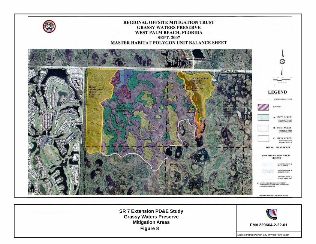
There are several mitigation areas within the Grassy Waters Preserve (Figure 5 and Figure 8). No
direct impacts will occur within the mitigation areas. One mitigation area, a 165 acre site used
by the Lennar Corporation as an offsite mitigation site for impacts associated with the Bay Hill
community, occurs adjacent to the project.
Secondary wetland impacts were calculated within a 300-foot buffer of the direct wetland
impacts occurring within the existing right-of-way. Secondary wetland impacts to Grassy
Waters Preserve equal 100.04 acres and include both wetland and surface waters habitats. The
FDOT will continue to coordinate with the City, permitting and wildlife regulatory agencies to
ensure any potential secondary impacts to wildlife and/or wetlands due to construction activities
are minimal. It is unlikely that the proposed improvements will substantially impair the function,
integrity, use, access, value or setting of this resource.
Fire management is an integral part of natural resource management. Having roads abutting the
two sides of the site will restrict when fire management activities can take place but would not
prevent the county from conducting this management activity and would not result in an adverse
impact to fire management activities within the facility.
B-12. GRANTS APPLICABLE TO SECTION 4(F) PROPERTIES
The Grassy Waters Preserve was provisioned under a Special Act of the State Legislative Act
(est. 1958) to provide legal authority and administration of the 20+ square-mile marsh system for
the purpose of water supply augmentation and habitat set aside.
SR 7 Extension PD&E StudyGrassy Waters Preserve
Mitigation AreasFigure 8 FM# 229664-2-22-01
Source: Patrick Painter, City of West Palm Beach
Section 4(f) Determination of Applicability 33 SR 7 Extension PD&E Study
C. IBIS PRESERVE
C-1. DETAILED MAP – RELATIONSHIP TO ALTERNATIVES
See Figure 5, Potential Section 4(f) Resource Map showing the proposed alignment of SR 7 in
relation to the Ibis Preserve. All of the proposed roadway and drainage improvements are within
the existing FDOT and Palm Beach County right-of-way; therefore, no additional right-of-way
will be required. The eastern boundary of the preserve area immediately abuts the existing
transportation right-of-way.
C-2. SIZE AND LOCATION OF THE AFFECTED SECTION 4(F) PROPERTIES
The size of the Ibis Preserve is 366 acres (148.14 hectares). The Preserve is located between the
north of the M-Canal and south of the Ibis Golf and Country Club (Figure 5). The area is
separated into two wetland preservation areas (Wetland Preservation Area No. 1 and Wetland
Preservation Area No. 2) due to an existing roadway right-of-way easement that bisects the area
(See Appendix D). Wetland Preservation Area No.2 is closest to the proposed SR 7 extension.
C-3. OWNERSHIP AND TYPE OF SECTION 4(F) PROPERTY
The owner of the Ibis Preserve is the City of West Palm Beach. The property was set aside as
wetland preservation/mitigation to compensate for impacts associated with the construction of
the Ibis Golf and Country Club.
C-4. FUNCTION / AVAILABLE ACTIVITIES
This preserve was created as part of mitigation for the Ibis Golf and Country Club. There are no
known recreational activities or facilities. The preserve is dedicated for wetland preservation and
is predominantly freshwater marsh. Due to its proximity to Grassy Waters Preserve and the
Pond Cypress Natural Area it is assumed that similar species utilize this wetland area for
foraging and nesting.
C-5. EXISTING AND PLANNED FACILITIES
There are no known existing or planned public use facilities within Ibis Preserve.
C-6. ACCESS AND USAGE
There are no formal public use entry points to the area.
Section 4(f) Determination of Applicability 34 SR 7 Extension PD&E Study
C-7. RELATIONSHIP TO OTHER SIMILARLY USED LANDS IN THE VICINITY
The Ibis Preserve is in direct proximity to the Grassy Waters Preserve (to the east) and the Pond
Cypress Natural Area (to the south). Due to the similarity of natural resources in Ibis Preserve to
that of the adjacent natural areas, it is assumed that similar wildlife utilization occurs. There are
no known recreational activities or facilities.
C-8. APPLICABLE CLAUSE AFFECTING THE OWNERSHIP
A 25-foot conservation easement borders that borders the interior boundaries of Wetland
Preservation Area No. 1.
C-9. UNUSUAL CHARACTERISTICS
The Ibis Preserve is a wetland preserve/mitigation site set aside to compensate for impacts
associated with the construction of the Ibis Golf and Country Club. The prairie and marsh
wetlands located within the Ibis Preserve are the same as those found in the Grassy Waters
Preserve and the Pond Cypress Natural Area. Therefore, it is presumed that the area attracts
similar wading birds and water fowl, and offers foraging and potential nesting habitat for the
same endangered and threatened species known to occur within the adjacent natural areas.
C-10. STATEMENT OF SIGNIFICANCE
A statement of significance from the City of West Palm Beach has not been received for the Ibis
Preserve.
C-11. CONSTRUCTIVE USE / PROXIMITY IMPACTS
All construction activities associated with the proposed improvements will be maintained within
the existing right-of-way, therefore, no additional right-of-way will be required. The drainage
treatment methodology will consist of a dry retention swale for water quality followed by a wet
detention pond for attenuation for the section of the roadway adjacent to the Ibis Preserve and the
Grassy Waters Preserve. The Ibis lake system is proposed as the outfall location for this segment
of the project. The Ibis water management system consists of a series of interconnected lakes
and streams (Class III water) that discharges into the Ibis Preserve and ultimately into the Grassy
Waters Preserve. The existing Ibis development water management system permit includes
provisions for accepting runoff from the SR 7 right-of-way. No direct discharge is proposed into
the Grassy Waters Preserve.
Section 4(f) Determination of Applicability 35 SR 7 Extension PD&E Study
All construction activities will remain within the existing right-of-way; therefore, no temporary
impacts are anticipated.
Secondary wetland impacts were calculated within a 300-foot buffer of the direct wetland
impacts occurring within the existing right-of-way. Secondary wetland impacts to Ibis Preserve
equal 32.69 acres and include all wetland habitat types and surface waters. The FDOT will
continue to coordinate with the City, permitting and wildlife regulatory agencies to ensure any
potential secondary impacts to wildlife and/or wetlands due to construction activities are
minimal. It is unlikely that the proposed improvements will substantially impair the function,
integrity, use, access, value or setting of this resource.
C-12. GRANTS APPLICABLE TO SECTION 4(F) PROPERTIES
There are no known grants applicable to this resource.
Section 4(f) Determination of Applicability 36 SR 7 Extension PD&E Study
D. LOXAHATCHEE SLOUGH NATURAL AREA
D-1. A DETAILED MAP IDENTIFYING THE RELATIONSHIP OF THE PROPOSED
PROJECT ALTERNATIVES TO THE SECTION 4(F) PROPERTIES
See Figure 8, Potential Section 4(f) Resource Map showing the proposed alignment of SR 7 in
relation to Loxahatchee Slough Natural Area.
The site is located north of the project terminus on the north side of existing right-of-way along
Northlake Boulevard. No improvements are proposed within or immediately adjacent to the
Loxahatchee Slough Natural Area; therefore, no direct or temporary impacts are expected.
D-2. SIZE AND LOCATION OF THE AFFECTED SECTION 4(F) PROPERTIES
The size of the Loxahatchee Slough is approximately 12,836 acres (5,194.54 hectares). It is
located within the City of Palm Beach Gardens and extends for seven miles north to Jupiter
Farms and south of the intersection of SR 710 (Beeline Highway) and PGA Boulevard on both
sides of SR 710 (Beeline Highway). The portion of the Loxahatchee Slough located south of SR
710 (Beeline Highway) and north of Northlake Boulevard is the area closest to the proposed SR
7 extension project.
D-3. OWNERSHIP AND TYPE OF SECTION 4(F) PROPERTY
The Slough is primarily owned and managed by Palm Beach County ERM although a portion is
managed by the South Florida Water Management District but will be eventually be transferred
to Palm Beach County.
D-4. FUNCTION / AVAILABLE ACTIVITIES
The Palm Beach County ERM considers this site to be a significant wetland. The slough is a
wide, shallow channel of water that provides a deep drainage way through a historical strand
swamp and peat soil swale system. The property also serves as the headwaters for the
Loxahatchee River which is a designated Wild and Scenic River. Areas of the Slough are open
to the public for environmental education, scientific research, and passive recreation activities,
such as nature walks, bird watching, and photography.
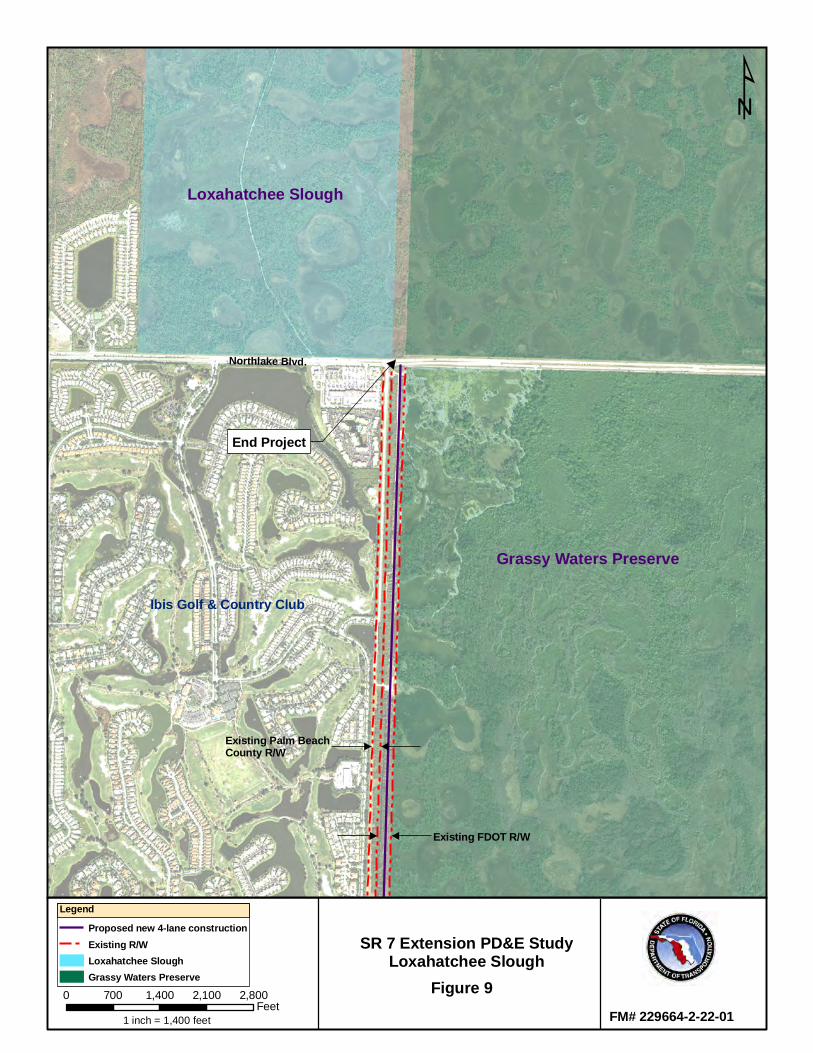
End Project
Northlake Blvd.
Existing Palm BeachCounty R/W
Existing FDOT R/W
Ibis Golf & Country Club
Grassy Waters Preserve
Loxahatchee Slough
SR 7 Extension PD&E StudyLoxahatchee Slough
Figure 9
¹
FM# 229664-2-22-01
LegendProposed new 4-lane constructionExisting R/WLoxahatchee SloughGrassy Waters Preserve
0 700 1,400 2,100 2,800Feet
1 inch = 1,400 feet
Section 4(f) Determination of Applicability 38 SR 7 Extension PD&E Study
D-5. EXISTING AND PLANNED FACILITIES
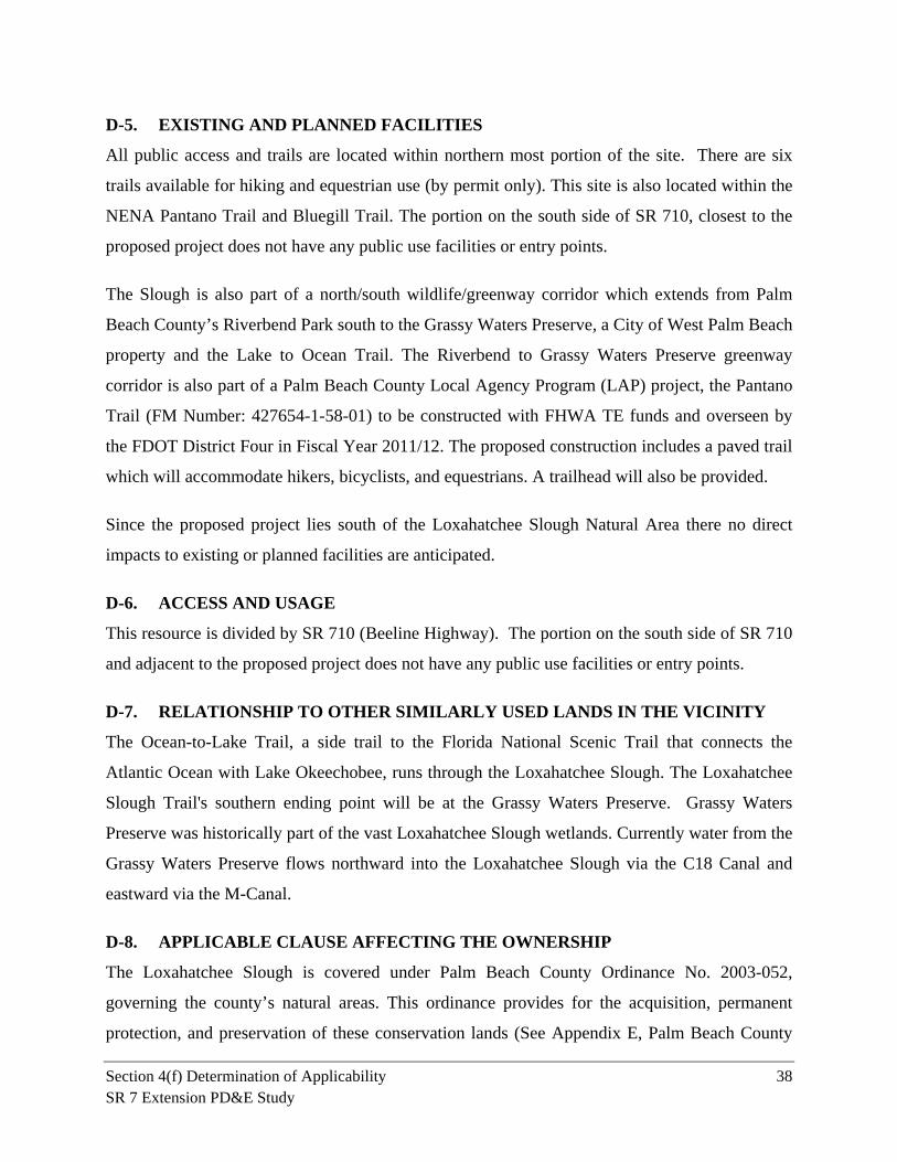
All public access and trails are located within northern most portion of the site. There are six
trails available for hiking and equestrian use (by permit only). This site is also located within the
NENA Pantano Trail and Bluegill Trail. The portion on the south side of SR 710, closest to the
proposed project does not have any public use facilities or entry points.
The Slough is also part of a north/south wildlife/greenway corridor which extends from Palm
Beach County’s Riverbend Park south to the Grassy Waters Preserve, a City of West Palm Beach
property and the Lake to Ocean Trail. The Riverbend to Grassy Waters Preserve greenway
corridor is also part of a Palm Beach County Local Agency Program (LAP) project, the Pantano
Trail (FM Number: 427654-1-58-01) to be constructed with FHWA TE funds and overseen by
the FDOT District Four in Fiscal Year 2011/12. The proposed construction includes a paved trail
which will accommodate hikers, bicyclists, and equestrians. A trailhead will also be provided.
Since the proposed project lies south of the Loxahatchee Slough Natural Area there no direct
impacts to existing or planned facilities are anticipated.
D-6. ACCESS AND USAGE
This resource is divided by SR 710 (Beeline Highway). The portion on the south side of SR 710
and adjacent to the proposed project does not have any public use facilities or entry points.
D-7. RELATIONSHIP TO OTHER SIMILARLY USED LANDS IN THE VICINITY
The Ocean-to-Lake Trail, a side trail to the Florida National Scenic Trail that connects the
Atlantic Ocean with Lake Okeechobee, runs through the Loxahatchee Slough. The Loxahatchee
Slough Trail's southern ending point will be at the Grassy Waters Preserve. Grassy Waters
Preserve was historically part of the vast Loxahatchee Slough wetlands. Currently water from the
Grassy Waters Preserve flows northward into the Loxahatchee Slough via the C18 Canal and
eastward via the M-Canal.
D-8. APPLICABLE CLAUSE AFFECTING THE OWNERSHIP
The Loxahatchee Slough is covered under Palm Beach County Ordinance No. 2003-052,
governing the county’s natural areas. This ordinance provides for the acquisition, permanent
protection, and preservation of these conservation lands (See Appendix E, Palm Beach County
Section 4(f) Determination of Applicability 39 SR 7 Extension PD&E Study
Ordinance). A conservation easement has been granted to the county by the South Florida Water
Management District on the Loxahatchee Slough.
D-9. UNUSUAL CHARACTERISTICS
The property serves as the headwaters for the Loxahatchee River, a designated Wild and Scenic
River and is a regionally significant wetland according to Palm Beach County ERM.
D-10. STATEMENT OF SIGNIFICANCE
A statement of significance from Palm Beach County has not been received for this project for
the Loxahatchee Slough Natural Area. A statement of significance was submitted by the City for
the SR 710 (Beeline Highway) PD&E Study which also potentially effects this site (Appendix
E). In 2010, FHWA determined the Loxahatchee Slough Natural Area to be a Section 4(f)
resource for the SR 710 (Beeline Highway) PD&E study, due to its function as a wildlife refuge.
D-11. CONSTRUCTIVE USE / PROXIMITY IMPACTS
The SR 7 extension terminates south of this site, therefore, no encroachment within the resources
or additional right-of-way take will occur within this site. Furthermore, construction activities
will not be within close proximity to this resource.
D-12. GRANTS APPLICABLE TO SECTION 4(F) PROPERTIES
Most of the lands in this Loxahatchee Slough were purchased through bond funds authorized by
two referendums approved by Palm Beach County voters for the purchase of environmentally
sensitive lands and conservation lands. Portions of these sites also were obtained through other
means such as donations, land swaps, mitigation funds and eminent domain actions. A Natural
Resources Conservation Service grant and multiple state exotic vegetation removal grants have
been given for this site as well.
Section 4(f) Determination of Applicability 40 SR 7 Extension PD&E Study
V. REFERENCES
Florida Department of Transportation. Project Development & Environment Manual, Part 2,
Chapter 13 Section 4(f) Evaluations (1998, May 22). Retrieved May 22, 2011:
http://www.dot.state.fl.us/emo/pubs/pdeman/pt2ch13.pdf
Federal Highway Adiministration. Section 4(f) Policy Paper (2005, March 1). Retrieved May 18,
2011, from FHWA Environmental Review Toolkit:
http://www.environment.fhwa.dot.gov/4f/4fpolicy.pdf
Florida Department of Transportation. Section 4(f) Determination of Applicability for SR 710
(Beeline Highway) Project Development and Environment (PD&E) Study (2010, August 23).
Obtained from FDOT, District 4.

Appendix A
Alternatives Figures
Appendix B
Additional Information for
Pond Cypress Natural Area
Appendix C
Additional Information for
Grassy Waters Preserve
Appendix D
Additional Information for
Ibis Preserve
Appendix E
Additional Information for
Loxahatchee Slough