section 2 piedmont triad overview - cityofws.org
TRANSCRIPT
Winston-Salem Urban Area MPO 2040 Metropolitan Transportation Plan Piedmont Triad Overview - Page 1
2.1 Geographic Area The Piedmont Triad is a geographically diverse 12-county region located in central North Carolina along the 1-40/I-85 corridor between Raleigh and Charlotte. In addition to being located centrally in North Carolina, the Piedmont Triad has a central East Coast location, midway between New York and Miami; Washington, D.C. and Atlanta, and within 650 miles of more than half the U.S. population and major markets. See Map 2-1 Piedmont Triad Region—Location, Map 2-2 Piedmont Triad Region—Geography, and Map 2-3 Piedmont Triad Region—Major Roadways. While most people in the Piedmont Triad Region live in urban areas, most of the land area is considered rural. According to US Census definitions, 2/3rds of the population of the 12-county region lived in urbanized areas or urbanized clusters in 2010. In contrast, however, 57% of the land area is rural (defined as less than 100 people per square mile) and an additional 29% of the land area is rural transition (defined as less than 250 people per square mile.)
Executive Summary/Key Points This chapter provides context for the 2040 MTP, including
o An overview of the geography, demographics and economic characteristics of the region and the MPO;
o A summary of local and regional land use planning efforts; o Methodology on the socioeconomic forecast and the regional travel demand model; and o Recommendations related to land use and transportation coordination; regional
cooperation and coordination; and the regional travel demand model. MPOs in the Triad region are projected to grow by approximately 130,000 households and
almost 200,000 jobs by 2040. Growth in the Winston-Salem MPO is expected to account for a significant portion of this, with an increase of over 45,000 household and over 63,000 jobs by 2040. Expanded housing and transportation choices will be needed to meet changing demand and demographics.
By having a regional transportation organization and one regional council now in place, the Triad is positioned for cooperative planning and successful regional land use and transportation initiatives.
Map and Table References
Maps Map 2-1 Piedmont Triad Region—Location Map 2-2 Piedmont Triad Region—Geography Map 2-3 Piedmont Triad Region—Major Roadways Map 2-4 Piedmont Triad Metropolitan Planning Organizations Map 2-5 Winston-Salem Urban Area Metropolitan Area Boundary Map 2-6 Winston-Salem MPO Household Density by TAZ 2013 and 2040 Map 2-7 Winston-Salem MPO Employment Density by TAZ 2013 and 2040 Tables Table 2.1 Economic Characteristics of Forsyth County, the Region and North Carolina Table 2.2 Winston-Salem MPO Population, Households and Employment
2. Piedmont Triad Overview

AtlanticOcean
TENNESSEE
WESTVIRGINIA
GEORGIA
SOUTHCAROLINA
KENTUCKY
MARYLAND
NORTHCAROLINA
VIRGINIA
Atlanta
Augusta
Charlotte
Durham
Fayetteville
Greensboro
Raleigh
Winston-SalemKnoxville
Chesapeake
NewportNews
Norfolk
Richmond
Virginia Beach
AlpharettaAthensJohns Creek
Macon
RoswellSandy Springs
Smyrna
WarnerRobins
Asheville
BurlingtonCary
ChapelHill
ConcordGastonia
Greenville
HighPoint
Jacksonville
RockyMount
Wilmington
Charleston
Columbia
Greenville
MountPleasant
NorthCharleston
RockHill
JohnsonCity
Kingsport
Hampton
Lynchburg
Portsmouth
Roanoke
Suffolk
Map 2-1 Piedmont Triad Region - Location
0 25 5012.5 Miles

HighRockLake
BadinLake
HycoLake
Belews Lake
LakeNorman
Uwha
rrie R
iver
Abbo
ttsCree
k Deep RiverYadkin
Rive
r
Haw River
Haw River
DeepRive
r
DAN RIVERSURRY
YADKIN
DAVIE
STOKES
FORSYTH
DAVIDSON
ROCKINGHAM
GUILFORD
RANDOLPH
MONTGOMERY
CASWELL
ALAMANCEArchdale
Asheboro
Burlington
Eden
GrahamGreensboro
HighPoint
King
Lexington
Mebane
MountAiry
Randleman
Reidsville
ThomasvilleTrinity
Winston-Salem
BermudaRun
Bethania
Biscoe
Boonville
Candor
Cooleemee
Danbury
Denton
Dobson
EastBend
Elkin
Elon
Franklinville
GreenLevel
Jamestown
Jonesville
Lewisville
Liberty
Madison
Mayodan
Midway
Milton
Mocksville
MountGilead
OakRidge Ossipee
PilotMountain
PleasantGarden
Ramseur
Seagrove
Staley
Star
Stokesdale
Stoneville
Summerfield
Swepsonville
Troy
Walkertown
Wallburg
WalnutCove
Wentworth
Whitsett
Yadkinville
Yanceyville
AlamanceClemmons
Tobaccoville
Kernersville
RuralHall
Copyright:© 2014 Esri
Map 2-2 Piedmont Triad Region - Geography
"0 7.5 153.75 Miles

Winston-Salem Urban Area MPO 2040 Metropolitan Transportation Plan Piedmont Triad Overview - Page 4
Counties in the Piedmont Triad Region are: Surry, Stokes, Rockingham, Yadkin, Forsyth, Guilford, Alamance, Davie, Davidson, Caswell, Randolph, and Montgomery. The major cities in the Triad are: Winston-Salem, Greensboro and High Point. The Triad includes four Metropolitan Planning Organizations (MPOs), Winston-Salem Urban Area, Greensboro Urban Area, High Point Urban Area and Burlington-Graham and two Rural Planning Organizations (RPOs), Northwest Piedmont and Piedmont Triad. See Map 2-4, Piedmont Triad Metropolitan Planning Organizations. The Winston-Salem Urban Area MPO is in the northwestern part of the Piedmont Triad and includes most of Forsyth County, along with southwestern Stokes County, northeastern Davie County, and
northern Davidson County. Winston-Salem is by far the largest city in the Urban Area. Other municipalities in the Winston-Salem Urban Area are (in order of population): Kernersville, Clemmons, Lewisville, King, Midway, Walkertown, Rural Hall, Tobaccoville, Bermuda Run, Wallburg, and Bethania. In September 2012, the Transportation Advisory Committee (TAC) of the Winston-Salem Urban Area MPO adopted a new Metropolitan Area Boundary (MAB) based on the Census Bureau’s 2010 defined urbanized area and negotiations with jurisdictions and MPOs in the region. The Winston-Salem MPO began planning for the new MAB after adoption of the 2035 Long Range Transportation Plan in January 2013, so this is the first long range plan covering the expanded MAB. The new Winston-Salem Urban Area MAB is shown on Map 2-5.
2.2 Demographics The 12-county Piedmont Triad Region had a population of 1,647,293 in 2010 (per the US Census), a 12% increase from 2000. According to the State Budget Office, the population of the Piedmont Triad is expected to growth to almost 1.9 million by 2035. Ninety percent of the growth is projected to be in the urban counties of Forsyth, Guilford and Alamance. The primary metropolitan centers of the region are Greensboro, Winston-Salem and High Point. Together, these cities ranked as the 33rd largest Combined Statistical Area (CSA) in US in 2013. The Winston-Salem Urban Area MPO had an estimated population of 414,092 in 2013. Based on 2010 census population figures, the Winston-Salem MPO was the third most populous MPO in North Carolina, following the Mecklenberg-Union MPO (Charlotte) and the Capital Area MPO (Raleigh). As of the 2010 Census, Forsyth County was the fourth most populous county and Winston-Salem was the fourth most populous city in North Carolina. Population, household and employment estimates and projections for the Winston-Salem Urban Area are included in section 2.5, Socioeconomic Forecast, below.
Map 2-3 Piedmont Triad Region— Major Roadways

Archdale
Asheboro
Eden
Graham
Greensboro
HighPoint
Lexington
Mebane
MountAiry
Randleman
Reidsville
Thomasville Trinity
Winston-Salem
BermudaRun
Bethania
Biscoe
Boonville
Candor
Cooleemee
Denton
Dobson
EastBend
Elkin
Franklinville
GibsonvilleGreenLevel
Jamestown
Jonesville
Lewisville
Liberty
MadisonMayodan
Midway
Milton
Mocksville
MountGilead
OakRidge Ossipee
PilotMountain
PleasantGarden
Ramseur
Seagrove
Sedalia
Staley
Star
Stokesdale
Stoneville
Summerfield
Swepsonville
Troy
Walkertown
Wallburg
Wentworth
Whitsett
Yadkinville
Yanceyville
AlamanceClemmons
Tobaccoville
Kernersville
RuralHall
KingWalnutCove
Danbury
HighCountry
RPOKerr-Tar RPO
LumberRiver RPO
Mid-CarolinaRPO
NorthwestPiedmont
RPO
PiedmontTriad RPO
RockyRiver RPO
TriangleArea RPO
UnifourRPO
SURRY
YADKIN
DAVIE
STOKES
FORSYTH
DAVIDSON
ROCKINGHAM
GUILFORD
RANDOLPH
MONTGOMERY
CASWELL
ALAMANCE
Burlington-GrahamMPO
CabarrusRowan MPO
CapitalArea MPO
DurhamChapel Hill
Carrboro MPO
FayettevilleArea MPO
Gaston-Cleveland-LincolnMPO
GreaterHickory
MPO
GreensboroUrban
Area MPO
High PointUrban
Area MPO
Charlotte RegionalTransportation
Planning Organization
Winston-SalemUrban Area MPO
Map 2-4 Piedmont Triad Metropolitan Planning Organizations (MPOs)
0 10 205 Miles

NorthwestPiedmont
RPO
PiedmontTriad RPO
UnifourRPO
GreensboroUrban
Area MPO
High PointUrban
Area MPO
CharlotteRegional
TPO
Winston-SalemUrban Area MPO
SURRY
YADKIN
DAVIE
STOKES
FORSYTH
DAVIDSON
ROCKINGHAM
GUILFORD
RANDOLPHArchdale
Greensboro
HighPoint
Thomasville Trinity
Winston-Salem
BermudaRun
Bethania
Boonville
Dobson
EastBend
Jamestown
Lewisville
MadisonMayodan
Midway
Mocksville
OakRidge
PilotMountain
Stokesdale
Summerfield
Walkertown
Wallburg
Yadkinville
Clemmons
Tobaccoville
Kernersville
RuralHall
King
WalnutCove
Map 2-5 Winston-Salem Urban Area Metropolitan Planning Organization (WSMPO)0 2 41 Miles

Winston-Salem Urban Area MPO 2040 Metropolitan Transportation Plan Piedmont Triad Overview - Page 7
2.3 Economic Characteristics The Piedmont Triad Region has a generally strong economic climate, compared to many other areas of the United States. Major industries include manufacturing, services, health care, logistics and distribution, and financial services. The region is home to eleven four-year colleges and universities and nine community colleges. The region’s central North Carolina and East Coast location, moderate climate, and educated workforce make it an attractive place to live and work. Economic statistics for the Piedmont Triad Region, including unemployment, educational attainment and income/poverty, are generally similar to those for the state as a whole. Economic statistics for Forsyth County are somewhat stronger than those for the region and the state. See Table 2.1 below.
Table 2.1 Economic Characteristics of Forsyth County, the Region, and North Carolina Forsyth
County Piedmont Triad
Region North
Carolina Unemployment Rate (2014) 5.9% 6.1% 6.1% Educational Attainment-- % at least HS Graduate*
87% 83.5% 84.9%
Educational Attainment – % at least Bachelors Degree*
31.9% 24.6% 27.3%
Per Capita Income $26,541 $24,196 $25,284 % Population Below Poverty Level 18.6% 18.1% 17.5% Average Travel Time to Work (in minutes) 20.6 22.7 23.6
*of population 25 and older
2.4 Land Use and Development Regional Efforts The Piedmont Triad has history of both fragmented and cooperative planning for land use and transportation. Fortunately, we currently have many cooperative efforts underway in a wide range of areas, including economic development, transportation, and sustainable growth. Piedmont Authority for Regional Transportation: The Piedmont Authority for Regional Transportation (PART) was created through State enabling legislation in 1997 (GS 160A-630). Its members include the four Triad MPOs (Burlington-Graham, Greensboro, High Point, and Winston-Salem), the counties of Alamance, Davidson, Davie, Forsyth, Guilford, Randolph, Rockingham, Stokes, Surry, and Yadkin; and numerous cities, including Burlington, Greensboro, High Point and Winston-Salem. PART’s goal is to improve transportation through regional cooperation and its mission is to enhance the quality of all forms of transportation for each of our citizens through efficient use and protection of our natural, economic and human resources. In addition to providing regional transit service, PART provides travel demand management services, including ridesharing, van pools, awareness programs, and employer consultations, and has coordinated many regional transportation planning and land use efforts. PART serves as the conduit for coordinated transportation planning in the Piedmont Triad. Operating under Memorandums of Understanding and other agreements with local jurisdictions and State governments departments, PART facilitates planning activities that impact multiple jurisdictions. PART serves as the custodian for regional travel demand transportation model, the Piedmont Triad Regional Model (PTRM) and as the coordinating agency for Air Quality Conformity Determination efforts that must be undertaken by area MPOs and NCDOT. (See discussion below)

Winston-Salem Urban Area MPO 2040 Metropolitan Transportation Plan Piedmont Triad Overview - Page 8
PART is authorized to operate transportation services and systems, but has limited taxing authority. PART may levy a vehicle registration and/or a passenger vehicle rental fee in perpetuity subject to an initial authorization by affected Boards of County Commissioners. PART presently receives funds from a 5% vehicle rental tax in Davidson, Forsyth, Guilford, Stokes, Surry, and Yadkin Counties. PART also receives a vehicle registration fee for registered vehicles in Randolph County. NCDOT and Federal Transit Administration (FTA) grants have also been awarded for studies and services that are currently underway. Piedmont Triad Regional Council: From1979 until 2011, the Piedmont Triad region was served by two regional councils of government; however, in 2011, the Northwest Piedmont Council of Governments and the Piedmont Triad Council of Governments joined to create the Piedmont Triad Regional Council (PTRC0. By having one regional transportation organization (PART) and one regional council (PTRC) for the 12 counties and 62 municipalities, the Triad is now positioned for successful regional initiatives and expanded cooperative planning efforts. Regional Planning Efforts: Important recent regional planning efforts include:
Regional Travel Demand Model and Air Quality Conformity Analysis (1990s-present) See discussion below.
Triad Urban Land Use Project (TULUP) Growing Together in the Triad (late 1990s) PART’s Regional Transit System (1998-present) See Chapter 4 of this plan. Piedmont Triad Seamless Mobility Study (2008) Regional Commuter Rail Alternatives Analysis (2009) Piedmont Triad Aerotropolis Initiative (2009-present) Heart of the Triad Study (2009-10) Regional Transit Development Plan (2010) See discussion below. Piedmont Together: the Piedmont Triad Sustainable Communities Planning Project (PTSCPP)
(2010-present) See discussion below. Piedmont Together: the Piedmont Triad Sustainable Communities Planning Project: In March 2014 the region completed a regional planning process entitled Piedmont Together). After three years of study, research and public engagement the planning team developed 16 regional goals, 172 objectives supporting the goals, and 259 strategies for achieving the goals. The goals were developed around the five themes: Jobs, Housing, Transportation, Health Community and Places and Spaces. In additional to this regional vision 20 reports and documents were produced creating a wealth of knowledge about the Piedmont Triad. The data collected to date shows a strong connection between the location of housing and job opportunities, and the transportation choices linking the two. 51% of the people reside in Forsyth and Guilford counties, but 63% of the region’s jobs are located in these counties. The average family in the region spends over 50% of their income on the cost of housing and transportation. People are seeking housing in a more compact, walkable environment. In addition, over 20% of the region’s population will be over 60 years of age by 2030. Unfortunately, there is a mismatch between the current supply and the future needs for both housing and transportation choices. Our region will grow by 400,000 people by 2030. To maintain a high quality of life and convenient access to jobs, housing, and services, we need to work together to develop a safe, reliable and efficient regional multimodal transportation network.

Winston-Salem Urban Area MPO 2040 Metropolitan Transportation Plan Piedmont Triad Overview - Page 9
The Vision: Equity and inclusion became the guiding pillars of Piedmont Together vision to build a resilient, prosperous economy and a better quality of life for all of the Piedmont Triad’s residents. Communities of color are driving the Piedmont Triad’s population growth, and their ability to participate in the economy and thrive is central to the region’s economic success now and in the future. The region’s slow economic recovery – combined with rising inequality and wide racial gaps in income, education, and opportunity – place the region’s economic future at risk. Inclusive growth is the path to economic prosperity in the Triad. By growing good jobs, investing in its increasingly diverse workforce, and infusing economic inclusion into its economic development and growth strategies, the region’s leaders can put all of its residents on the path toward reaching their full potential and secure a bright economic future for the region. Transportation related items can be found throughout all fives themes. Twenty-seven strategies are tied to transportation. The Mobility in the Triad report identified many key goals and objectives related to transportation:
Provide more transportation choices through the development of safe, reliable and economical transportation infrastructure and services to decrease household transportation costs, reduce our nation’s dependence on foreign oil, improve air quality, and promote public health.
Establish and enhance a robust network of multi-modal transportation choices at the statewide, regional, county and municipal levels involving highways, passenger and freight rail, regional and local transit, streets, para-transit services, sidewalks, cycling infrastructure, and recreational trails and greenways.
Maintain and enhance the region’s competitive edge as a transportation and logistics hub along the Eastern Seaboard by focusing on facilities and infrastructure planning, improving coordination and cooperation among stakeholders.
The vision of Piedmont Together – A Comprehensive Regional Plan has been adopted by the Piedmont Authority for Regional Transportation Board of Trustees and the Piedmont Triad Regional Council Board of Delegates. The Winston-Salem, Greensoro and High Point MPO’s and the Northwest and Piedmont Triad RPO’s have supported the regional vision and endorsed the plan’s vision. The Transportation Advisory Committee of the Winston-Salem MPO endorsed the plan in March 2015. Objectives and recommendations from the Piedmont Together plan elated to regional transportation and logistics have been included in the Transportation Vision and Objectives, Policies, and Action Agenda in section 1.4 of this plan.
Moving Forward: There are numerous non-profits, entities, agencies and units of government working on behalf of their communities. But there are only two entities working at the regional level: Piedmont Authority for Regional Transportation and Piedmont Triad Regional Council, both
Piedmont Together is a consortium of public and private entities collaborating on equitable solutions designed to meet the needs of each community in the region.
Piedmont Together collaborates on building equitable solutions to strengthen our region, economically, socially, culturally, and ecologically through the implementation of our region plan. Roles
Regional Convener
Regional Catalyst
Regional Capacity Builder
Regional Collaborator Goals
Citizen Engagement
Knowledge Sharing (education, technical assistance)
Connecting Governments and Communities
Building Regional Identity

Winston-Salem Urban Area MPO 2040 Metropolitan Transportation Plan Piedmont Triad Overview - Page 10
government units. Piedmont Together is filling a gap that brings units of government together with non-profits to develop regional solutions that can be implemented at the community level. Piedmont Together is a massive undertaking which will have a positive impact on residents, educational institutions and businesses in Piedmont Triad. We cannot fail with equity, inclusion and opportunity for all as the lens that is used to create regional solutions implemented at the community level. Piedmont Together is helping to establish a renewed sense of regionalism and the Consortium is moving forward with establishing an organizational structure. The vision is for Piedmont Together to serve as a regional catalyst on equity, sustainability, facilitating community input, and providing a forum for dialogue between local government and non-profit agencies and grass roots groups to address challenges that face our region. We are confident that all this and more can be achieved through the minimal support of one staff person and the continued support of the region. Local Planning The dominant development pattern in the Winston-Salem Urban Area over the past fifty years has been scattered, sprawling suburban development, built at low densities and spreading farther into the countryside. When combined with zoning ordinances that require separation of employment, shopping and services from residential areas, the result is more and longer trips and an almost total dependence on the automobile. Until recently, active transportation options were given little emphasis and transit, bicycling and walking are not viable choices for most trips. Dispersed development patterns make it harder for our public transit systems to provide good service, attract riders and be cost-effective and efficient. Those who don’t or can’t drive, such as children, the elderly and the disabled, are totally dependent on others for transportation. Our spread-out development patterns and dependence on the automobile has had its price. More cars on the road cause create more accidents, account for lost time and productivity, and increase air pollution. Increased traffic requires new roads and the widening and maintenance of existing roads at a cost that we may no longer be able to afford. Ultimately, our traffic problems will reduce the quality of life in our community. Recently, citizens and public decision makers have begun to link transportation and land use planning, recognizing that we must alter our land use and development patterns to create a more efficient transportation system and make active transportation choices viable. Plans to guide the growth and development of a community go by a variety of names, including comprehensive plan, general development guide, land use or land development plan, and growth strategy. No matter what title is used, these plans traditionally are general, long-range policy guides for decisions concerning the overall growth and development of the community. Plans in place in jurisdictions in the Winston-Salem Urban Area include:
Forsyth County: Forsyth County and all its municipalities, including the City of Winston-Salem, adopted the Legacy 2030 Update in 2012 and 2013. In addition to the county-wide plan, most of the municipalities have adopted more detailed community or area plans, including a transportation component.
Davidson County: The Davidson County Land Development Plan, adopted in 2009, serves as a guide to help the community make land use decisions and to provide for the orderly growth and development of the county. The policies are included to serve as basis for future decisions regarding land use and development, transportation, and capital improvements.
Davie County: In 2010, Davie County adopted the Davie County Growth Enhancement Strategy to encourage quality, sustainable growth, to accommodate new growth while preserving heritage and rural resources, and to maintain a healthy balance between economic viability and livability by recognizing the direct connection between development and quality of life. In spring 2015, Davie County began working with a consultant to develop a plan for a new

Winston-Salem Urban Area MPO 2040 Metropolitan Transportation Plan Piedmont Triad Overview - Page 11
interchange on I-40 and other transportation needs. The Town of Bermuda Run adopted a comprehensive plan in 2012 to guide land use and growth, transportation, community character/identity, and public investment decisions.
Stokes County: Stokes County uses the Stokes County: A Land Development Guide to help manage its future growth. The plan was originally adopted in 1993 and re-adopted in 2006. The County and all the municipalities are in the process of reviewing a final draft of a new countywide land use plan which they hope to adopt by mid-summer 2015.
While the types of plans in the Winston-Salem Urban Area differ, they do share some common visions. Preserving the character and quality of the area, while accommodating anticipated growth and development, is a common theme among the localities. Important objectives in plans of Winston-Salem Urban Area jurisdictions include:
Accommodate growth and development while preserving the area’s quality of life, heritage, character and natural environment.
Coordinate land use, transportation and capital investment decisions to efficiently and cost effectively provide public facilities and services.
Create more compact and efficient patterns of development by increasing the overall density and intensity of residential and commercial development in areas with public sewer, good roads and other urban services.
Reduce dependence on the automobile by providing convenient and attractive choices including transit, walking and bicycling. Locate higher density developments at activity centers and along transit corridors to make transit viable; create attractive commercial developments close to neighborhoods; and invest in sidewalks, greenways and bikeways that connect neighborhoods to jobs, shopping centers and services.
Create vibrant village centers and downtowns with safe, clean, high quality public spaces, restaurants and specialty shops, and entertainment, sports and cultural events that attract people downtown to live, work, and shop.
Attain a more balanced pattern of development by giving priority to public expenditures in slow growth areas for such things as improved roads, schools, libraries and other facilities and services.
Prioritize re-use of vacant land and abandoned buildings over greenfield development. Retain farmland and open space by directing urban and suburban growth to existing
developed areas. Assure that development in rural areas enhances rural character.
2.5 Socioeconomic Data Forecast A key means of linking land use (current and future) to transportation planning is through the socioeconomic data projections used in the region travel demand model. Socioeconomic data (estimates and projections of population, households and employment) is first forecast at the aggregate level (typically by state, region and/or county) and then allocated to smaller and smaller geographies, down to the traffic analysis zone (TAZ) level. TAZ level data is used in the regional travel demand model to estimate trip attractions and trip productions. The socioeconomic data forecasts for the local travel demand model, the Piedmont Triad Regional Model (PTRM), were developed by Kimley Horn in consultation with the PTRM model team and local jurisdiction staff members in 2014. The base year was 2013, with a horizon year of 2040 and interim years of 2021 and 2030. The consultants, the model team and local jurisdiction staff undertook an extensive process to develop the region and county level forecasts and to allocate data down to the TAZ level. They used different approaches and data sources and based their assignments on a wide variety of factors, including build out potential, land suitability measures, local land use and transportation plans, and verified employment and school data. The first step in the socioeconomic data forecasting process was to establish county level control totals for population and employment for the base year (2013) and for horizon years (2021, 2030 and 2040.)

Winston-Salem Urban Area MPO 2040 Metropolitan Transportation Plan Piedmont Triad Overview - Page 12
Base Year Estimates The 2013 population and household data by TAZ were based on block level 2010 US Census data. Building permit and local development approvals were considered when forecasting the data from 2010 to 2013. Base employment data by TAZ was obtained for 2011 from InfoUSA, a leading national provider of business list and location data. Annualized growth rates by subarea were provided by ESRI (Environmental Systems Research Institute (ESRI) Business Analyst to forecast from 2011 to 2013. Recent employer expansions and contractions were also considered when forecasting data from 2011 to 2013. Horizon Year Projections County-level Control Totals: To establish control totals for the horizon years (2021, 2030 and 2040), four methods/sources were used:
A trend line forecast using historical data; An allocation methodology, a computer model previously developed for the 12-county
Piedmont Together Regional Scenario Planning Initiative, that factors in build out potential and land suitability. The Piedmont Together CommunityViz model was adapted to cover the smaller area covered by Travel Demand Model and to include additional information relevant to the travel demand model.
Projections from the North Carolina. Office of State Budget and Management (OSBM) – The OSBM has county-level population and household estimates and projections to the year 2035.
Projections from Woods and Poole (W&P) – W&P is an independent firm that specializes in long-term county economic and demographic projections. W&P has estimates and projections for households and employment to the year 2040.
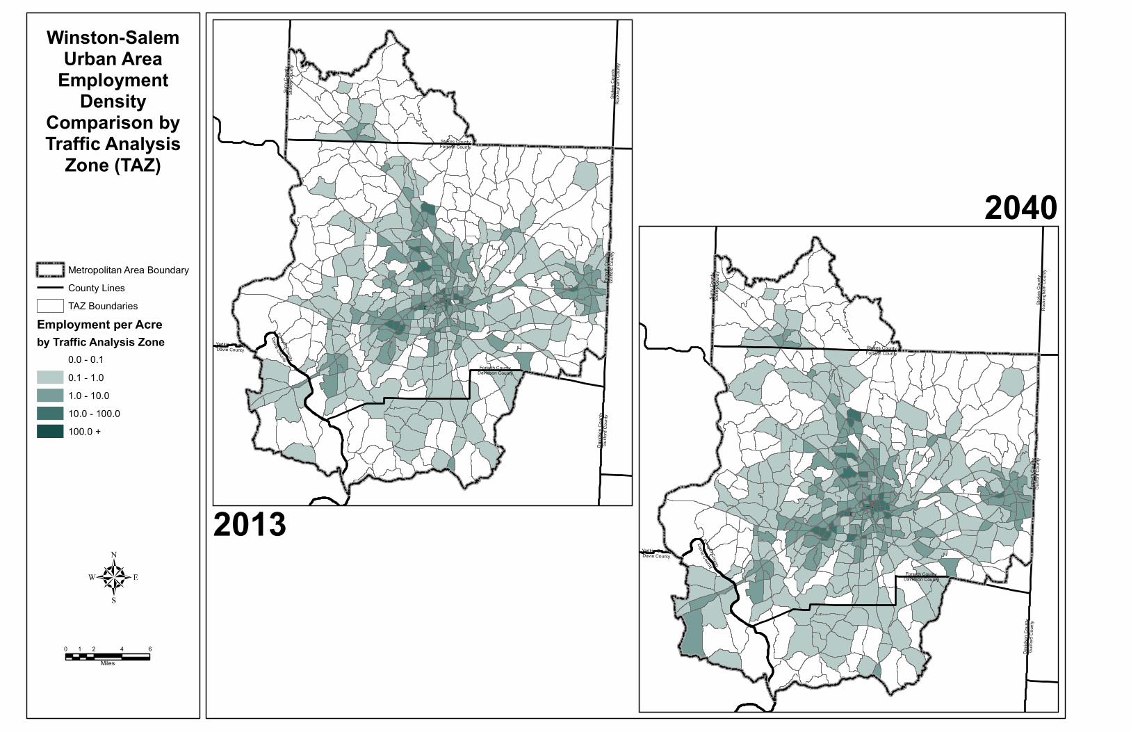
Following a review of all the forecasts, Kimley-Horn recommended household and employment control total projections for each county. The model team and county-level stakeholders (primarily land use and transportation planners) accepted the consultants’ recommendations with minor changes. The consultant used the household and employment control total projections, along with other data sources, to develop base year and forecasts for other model data inputs, including population, school enrollment, household automobiles and income. Projections by Traffic Analysis Zone (TAZ): The next step in the process was to distribute the horizon year increases in households and employment to subareas and TAZs for each county. Kimley-Horn used a computer-based allocation methodology that factored in build out potential, land suitability measures and local land use and transportation plans to allocate the households and jobs. The consultants provided the proposed allocations to the MPOs and local jurisdictions who used a variety of methods to review the allocations. In the Winston-Salem Urban Area MPO, WSDOT and City-County Planning staff reviewed the proposed Forsyth County allocations first by subarea and then individually by TAZs within each subarea. Staff from Kernersville, Clemmons and Lewisville were part of the review teams for subareas/TAZs within their respective jurisdictions. For areas in the Winston-Salem MPO outside of Forsyth County, WSDOT staff worked with staff from those counties to review the proposed allocations. Staff used their knowledge of the areas and factored in approved developments and plans (land use and transportation) to adjust allocations for the subareas and TAZs. In general, the county control totals were held constant and households and employment numbers shifted from one subarea or TAZ to another. It is noted that while additional households and employment were shifted to subareas and TAZs in and near the Town of Kernersville, staff from Kernersville still felt that an inadequate number of households and jobs were available for allocation within their jurisdiction. Maps 2-6 and 2-7 provide a comparison of the household and employment densities for TAZs in the Winston-Salem Urban Area.

Winston-Salem Urban Area MPO 2040 Metropolitan Transportation Plan Piedmont Triad Overview - Page 13
Table 2.2 below shows estimated and projected population, households and employment for the Winston-Salem Urban Area for 2013, 2021, 2030 and 2040 prepared for the socioeconomic forecast and used in the Piedmont Triad Regional Model for this 2040 Metropolitan Transportation Plan. Table 2.2 Winston-Salem Urban Area MPO Population, Households and Employment
2013
2021
2030
2040
Increase 2013-2040
% Increase 2013-2040
Population 414,092 442,471 474,413 552,867 95,799 23% Households 166,585 179,977 195,027 211,744 45,159 27% Employment 186,358 205,015 226,122 249,802 63,444 34%
2.6 Piedmont Triad Regional Model (PTRM) What is the PTRM? The Piedmont Triad Regional Model (PTRM) was developed cooperatively by United States Department of Transportation (USDOT), North Carolina Department of Transportation (NCDOT), Piedmont Authority for Regional Transportation (PART) and the four regional Metropolitan Planning Organizations (Greensboro, Winston-Salem, High Point, and Burlington-Graham). The PTRM is a multi-modal four-step regional travel demand model, designed to support long range transportation planning and programming decisions in the Triad region. More detailed analyses are Air quality conformity, Travel forecasts, Long range transportation plan development, Multimodal alternative analysis, Comprehensive transportation plan analysis, Regional analysis, and Framework for sub-area analysis. The PTRM completely covers the Metropolitan Area Boundaries (MABs) for the Winston-Salem MPO, which includes Forsyth County and parts of Davidson, Stokes and Davie County; the High Point MPO, which includes parts of Forsyth, Davidson and Guilford County; the Greensboro MPO (Guilford County) and the Burlington-Graham MPO, which includes Alamance County and parts of Guilford and Orange County. Alamance, Guilford and Forsyth counties are completely within the PTRM boundary. Stokes, Orange, Davie and Davidson Counties are partially covered by the PTRM.PART plays a model custodian’s role in developing, maintaining and updating the model. How does PTRM work? The PTRM utilizes a traditional four-step trip-based model process consisting of four basic steps below. Each step utilizes ‘state-of-the-practice’ and accepted mathematical models to objectively analyze why, where and how people travel.
Trip Generation: to predict the number of trips to be made Trip Distribution: to predict where those trips go Mode Choice (Modal Split): to predict whether people take transit, their own car, or a carpool
to and from work or another destination Traffic Assignment: to predict the route people will take
The PTRM is developed on a transportation planning software platform, called TransCAD by Caliper, which is Geographic Information System (GIS) designed specifically for use by transportation professionals to store, display, manage, and analyze transportation data. What does PTRM do? The PTRM analyzes socio-economic and travel characteristics data with the highway and transit network in the model area. Through the first two steps, the PTRM predicts how many people travel to and from with various purposes on a daily basis within/beyond Triad region. Through the last two steps, PTRM is performed to predict auto, transit and non-motorized travel demand (daily traffic volume, traffic volume by period) based on socio-economic data forecasts and

Winston-Salem Urban Area MPO 2040 Metropolitan Transportation Plan Piedmont Triad Overview - Page 14
level of service of the region’s road network and transit services at the model network consisting of roadways and transit routes for the future horizon years. When the entire process is completed, the PTRM generates a report consisting of summarized performance measures such as speed, VMT by county and functional class of roadways. This report is utilized as main input data in the various transportation analyses for the Federal, the State and MPOs. Air Quality and the PTRM Triad MPOs and NCDOT are required by federal regulations (23 CFR 134 and 40 CFR Parts 51 and 93) to make an air quality conformity determination on any newly adopted or amended fiscally constrained LRTP and TIP. Outputs from the PTRM feed into the air quality model used to prepare the required Air Quality Conformity Determination Report (see Chapter 8.) The purpose of the determination report is to document compliance with the provisions of the Clean Air Act Amendments of 1990 (CAAA) and the Transportation Equity Act for the 21st Century (TEA-21). The conformity determination for the 2007–2013 Transportation Improvement Program (TIP) is based on a regional emissions analysis that utilized the transportation networks in adopted and conforming Long Range Transportation Plans (LRTPs) and the emissions factors developed by the North Carolina Department of Environment and Natural Resources (NCDENR). All regionally significant federally funded projects in areas designated by the United States Environmental Protection Agency (USEPA) as air quality nonattainment or maintenance areas must come from a conforming LRTP and TIP. A history of air quality in the Winston-Salem and the Triad Region prepared by the Forsyth County Office of Environmental Assistance and Protection is included in Appendix C of Chapter 7.

Surry
Cou
ntySt
okes
Cou
nty
Yadkin CountyDavie County
Davie CountyForsyth County
Stokes CountyForsyth County
Stok
es C
ounty
Rock
ingha
m Co
unty
Forsyth CountyDavidson County
Forsy
th Co
unty
Guilfo
rd Co
unty
David
son C
ounty
Guilfo
rd Co
unty
Surry
Cou
ntySt
okes
Cou
nty
Yadkin CountyDavie County
Davie CountyForsyth County
Stokes CountyForsyth County
Stok
es C
ounty
Rock
ingha
m Co
unty
Forsyth CountyDavidson County
Forsy
th Co
unty
Guilfo
rd Co
unty
David
son C
ounty
Guilfo
rd Co
unty
Metropolitan Area BoundaryCounty LinesTAZ Boundaries
Households per Acreby Traffic Analysis Zone
0.0 - 0.20.2 - 1.01.0 - 2.02.0 - 4.04.0 +
2013
2040
Winston-SalemUrban AreaHousehold
DensityComparison byTraffic Analysis
Zone (TAZ)
0 2 4 61Miles
Surry
Cou
ntySt
okes
Cou
nty
Yadkin CountyDavie County
Davie CountyForsyth County
Stokes CountyForsyth County
Stok
es C
ounty
Rock
ingha
m Co
unty
Forsyth CountyDavidson County
Forsy
th Co
unty
Guilfo
rd Co
unty
David
son C
ounty
Guilfo
rd Co
unty
Surry
Cou
ntySt
okes
Cou
nty
Yadkin CountyDavie County
Davie CountyForsyth County
Stokes CountyForsyth County
Stok
es C
ounty
Rock
ingha
m Co
unty
Forsyth CountyDavidson County
Forsy
th Co
unty
Guilfo
rd Co
unty
David
son C
ounty
Guilfo
rd Co
unty
2013
2040Metropolitan Area BoundaryCounty LinesTAZ Boundaries
Employment per Acreby Traffic Analysis Zone
0.0 - 0.10.1 - 1.01.0 - 10.010.0 - 100.0100.0 +
Winston-SalemUrban Area
EmploymentDensity
Comparison byTraffic Analysis
Zone (TAZ)
0 2 4 61Miles