section 1. the nickerson management complex
TRANSCRIPT

1-1
Dunes, beaches, and ocean views on a warm summer day; the iconic image of the Cape and Islands. (See Appendix G for photo information.)
SECTION 1. THE NICKERSON MANAGEMENT COMPLEX 1.1. INTRODUCTION
The Massachusetts Department of Conservation and Recreation (DCR) owns several properties on Cape Cod, Martha’s Vineyard, and Nantucket (i.e., the Cape and Islands). These properties, which are administered through Nickerson state park, are collectively referred to as the Nickerson Management Complex (i.e., the Complex). A map of the properties in the Complex is presented in Figure 1.1.
The Cape and Islands are well known for their Native American and colonial histories, scenic dunes and beaches, pleasure boating, and recreational and commercial fishing. These aspects drive the region’s most important industry, tourism. Second-home ownership and retirement populations also contribute to the region’s economy, and along with tourism, contribute to seasonal changes in population, which peaks during the summer. Estimates of seasonal population increase are 131.7% for Cape Cod and 400% for both Martha’s Vineyard and Nantucket (Richardson 2014, Martha’s Vineyard Commission 2006, Town of Nantucket n.d.).
The Complex’s parks are among the Cape and Islands’ most popular tourist destinations. Each year, hundreds of thousands of visitors enjoy the parks’ fresh and saltwater beaches, bike paths, hiking trails, and other amenities. In addition, the Complex’s two large campgrounds provide an affordable base from which visitors explore the region’s other tourist attractions.
The Complex is also home to some of the most important and sensitive resources in the Commonwealth. Rare plants and wildlife share beaches, pine barrens, pond shores, and heathlands with recreationists, as do archaeological sites that reflect more than 12,000 years of human habitation. These resources will persist, and in some cases flourish, only through informed management.
1.2. RESOURCE MANAGEMENT PLANS
The DCR is required to prepare management plans for “all reservations, parks, and forests under the management of the department” (M.G.L. Chapter 21: Section 2F). These plans “shall include guidelines for the operation and land stewardship of the aforementioned reservations, parks and forests, shall provide for the protection

The Nickerson Management Complex
1-2
This page intentionally left blank.

!Ï
!Ï
!Ï
!Ï
!Ï
!A
!A!A
!A
!A
!(28
!(6A
!(28
tu6
Plymouth
Barnstable
Falmouth
Sandwich
Bourne
Carver
Wareham
Dennis
Brewster
Mashpee
Harwich
Yarmouth
Orleans
Wellfleet
Eastham
Chatham
Marion
���195
���495
tu6
tu6
tu6
tu6
!(28
!(3
!(3A
!(25!(6A
!(28
NickersonState Park
WashburnIsland South Cape
Beach State Park
Shawme-CrowellState Forest
HawksnestState Park
Quashnet WoodsState Reservation
Cape CodRail Trail
Waquoit BayNERR
NamskaketSea Path
!A
!A
Edgartown
Chilmark
WestTisbury
TisburyOak
Bluffs
Gosnold
Aquinnah
Manuel F. CorrellusState Forest
Joseph SylviaState Beach
South BeachState Park
NantucketState Forest
Nantucket0 5Miles
0 5MilesCape Cod Bay
Nantucket Sound
Buzzards Bay
!A Fire Tower
!Ï Reforestation Lot
Major Road
Other Protected Open Space
Town Boundary
Nickerson Complex
Fee Interest
Conservation Restriction
Easement
0 42Miles
Geographic information provided by MassGIS and DCR GIS.
Figure 1.1. Nickerson Management Complex
µ1-3

The Nickerson Management Complex
1-5
and stewardship of natural and cultural resources and shall ensure consistency between recreation, resource protection, and sustainable forest management.”
This Resource Management Plan (RMP) provides an inventory and assessment of the environmental, cultural, and recreation resources; identifies current management practices and capabilities; and develops specific, implementable management recommendations to address the highest priority needs within the Nickerson Management Complex.
Public Input Public input is an important part of the RMP process. The legislative mandate that requires the preparation of management plans directs the Commissioner of the DCR to “seek and consider public input in the development of management plans, and ... make draft plans available for a public review and comment period through notice in the Environmental Monitor.”
There were two public input periods associated with the preparation of the Nickerson Management Complex RMP. Both included public notification, posting in the Environmental Monitor, a public meeting, and a public comment period. Additional information on public participation in the development of this plan is provided in Appendix B.
Natural Heritage and Endangered Species Program Involvement
The Massachusetts Natural Heritage and Endangered Species Program (NHESP) has regulatory authority for, and are experts on, the plants and animals protected under the Massachusetts Endangered Species Act (MESA; 321 CMR10:00). They provide assistance, in both capacities, with the preparation of RMPs. (See Appendix C for additional information.)
Stewardship Council
Following public comment and revision, draft RMPs are submitted to the DCR Stewardship Council for review. Each draft RMP is presented at a public meeting of the Stewardship Council for their approval. Once adopted, the RMP becomes final.
1.3. NICKERSON MANAGEMENT COMPLEX
This RMP covers the Nickerson Management Complex, which includes 12 parks, five reforestation lots, and several properties in which the DCR holds legal interest. (Figure 1.1) The term “park” is used generically throughout this RMP to refer to all manner of DCR properties that have recreation, administrative, or operations infrastructure, including state beaches, forests, and reservations.
The following 12 parks are included in the Nickerson Management Complex:
Shawme-Crowell State Forest (Shawme-Crowell)
Waquoit Bay National Estuarine Research Reserve (WBNERR)
South Cape Beach State Park (South Cape Beach)
Washburn Island Quashnet Woods State Reservation (Quashnet
Woods) Roland C. Nickerson State Park (Nickerson) Hawksnest State Park (Hawksnest) Cape Cod Rail Trail (CCRT) Manuel F. Correllus State Forest (Correllus) Joseph A. Sylvia State Beach (Sylvia) South Beach State Park (South Beach) Nantucket State Forest
Each of these parks is covered in Sections 2 through 13 of this RMP.
The Complex’s reforestation lots were initially acquired to promote the reestablishment of trees. They typically lack infrastructure, although forest roads may be present. The following reforestation lots are included in this RMP.
Sandwich Reforestation Lot (i.e., Weeks Lot) Falmouth Reforestation Lot (i.e., Perry Lot) Barnstable State Forest; Route 132 Lot (i.e.,
Shoot Flying Hill Lot) Barnstable State Forest; Old Stage Road Lot
(i.e., Eben Smith Lot) Brewster State Forest
All are addressed in Section 14 of this RMP.
The Nickerson Management Complex
1-6
The above properties, both parks and reforestation lots, are owned by the DCR. In addition to these properties, the Nickerson Management Complex also includes several private and municipal properties in which the DCR holds a conservation restriction. These properties are identified in Table 1.3.1. They are currently not being monitored for compliance with the terms of their conservation restrictions. Table 1.3.1. DCR-held conservation restrictions for
properties associated with the Nickerson Management Complex.a
Town Owner Acresa Sandwich Town of Sandwich 37.1 Mashpee Mashpee Tribal Council 0.4 Mashpee Town of Mashpee 7.6 Mashpee Orenda Wildlife Land Trust 13.7 Barnstable Barnstable Land Trust 24.4 Barnstable Town of Barnstable 80.5 Barnstable Jones Investment Trust 14.0 Dennis Town of Dennis 172.0 Brewster Town of Brewster 188.0 Brewster Brewster Conservation Trust 10.5 Eastham Town of Eastham 18.0 Edgartown/ West Tisbury
The County of Dukes County 22.9
West Tisbury Polly Hill Arboretum 60.6 Total 649.7 a. Approximate acreage (+/-), as reported in the conservation
restrictions.
The DCR also holds other legal interests in private lands, such as easements and deeded rights of access. This information is presented in individual chapters, as appropriate.
Seven DCR fire observation towers are located on or near properties in the Complex. Some are in parks, others are located on properties solely associated with fire towers, and one is located on municipal land. These seven towers are addressed in Section 15.
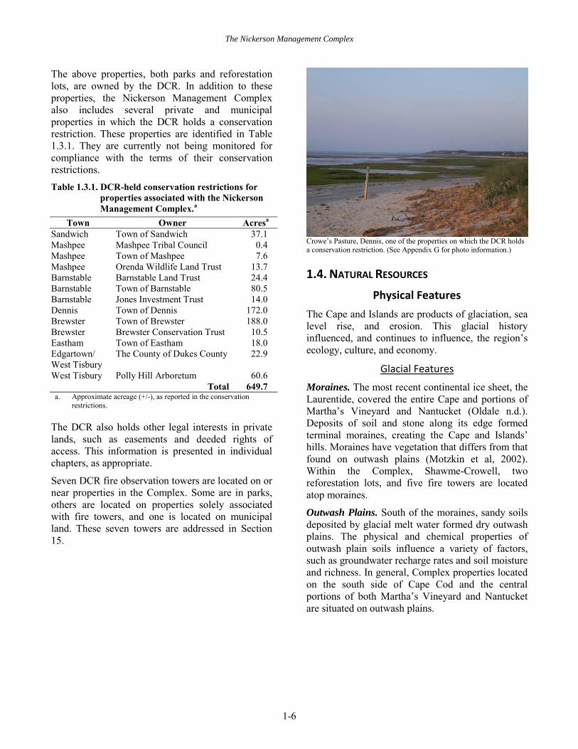
Crowe’s Pasture, Dennis, one of the properties on which the DCR holds a conservation restriction. (See Appendix G for photo information.)
1.4. NATURAL RESOURCES
Physical Features
The Cape and Islands are products of glaciation, sea level rise, and erosion. This glacial history influenced, and continues to influence, the region’s ecology, culture, and economy.
Glacial Features
Moraines. The most recent continental ice sheet, the Laurentide, covered the entire Cape and portions of Martha’s Vineyard and Nantucket (Oldale n.d.). Deposits of soil and stone along its edge formed terminal moraines, creating the Cape and Islands’ hills. Moraines have vegetation that differs from that found on outwash plains (Motzkin et al, 2002). Within the Complex, Shawme-Crowell, two reforestation lots, and five fire towers are located atop moraines.
Outwash Plains. South of the moraines, sandy soils deposited by glacial melt water formed dry outwash plains. The physical and chemical properties of outwash plain soils influence a variety of factors, such as groundwater recharge rates and soil moisture and richness. In general, Complex properties located on the south side of Cape Cod and the central portions of both Martha’s Vineyard and Nantucket are situated on outwash plains.

The Nickerson Management Complex
1-7
Coastal Erosion
The familiar shapes of today’s Cape and Islands were created by sea level rise and erosion. Rising sea level and coastal processes redistributed, and continue to redistribute, glacial soils. Sylvia, South Beach, and the shorelines of Nickerson, South Cape Beach, and Washburn Island sit atop beach depositions actively being redistributed by wind and waves.
The familiar outlines of Cape Cod (center) and Martha’s Vineyard (lower left) as viewed from space. (See Appendix G for photo information.)
Water Resources
Salt Marshes
Salt marshes provide the basis of complex estuarine and marine food chains, and are one of the most productive ecosystems on earth (NHESP 2012). They occur in protected estuarine waters of the Cape and Islands.
In 2001, 114 tidally restricted marshes (i.e., those with impeded water flow and salt marsh function) were documented on Cape Cod; five (MA-4, MA-5, BR-7/OR-1; EA-5, And OR-4/EA-3) were on DCR properties (Cape Cod Commission 2001). All have since been corrected. One tidal restriction, at Farm Pond, Oak Bluffs is believed to be partially on DCR property.
Barrier Beaches
Barrier beaches are “narrow, low-lying strips of land generally consisting of coastal beaches and coastal dunes extending roughly parallel to the trend of the coast” (310 CMR 10:29). They are protected by the Wetlands Protection Act (310 CMR 10:00) and
Massachusetts Executive Order 181. Under this Executive Order, management plans are required for all five of the Complex’s coastal properties that have one or more barrier beach.
Kettle Hole Ponds
Kettles are bowl-shaped depressions that form when a block of ice breaks off a glacier, is deposited in drift, and then melts. Kettle hole ponds, such as Cliff Pond at Nickerson, are typically steep sided and may or may not be connected to groundwater. Freshwater recreation is often associated with these sites.
Coastal Plain Ponds
Coastal plain ponds are shallow, highly acidic ponds with gently sloping, sandy shores. They are hydrologically connected to groundwater, with changes in water levels exposing or inundating the pondshore. Rare species are often associated with the shores of these ponds.
Vernal Pools
Vernal pools are temporarily flooded ponds that provide breeding habitat for amphibians and invertebrates. They are found throughout the Cape and Islands. Certified Vernal Pools (i.e., those that have undergone the NHESP’s certification process) “provide essential breeding habitat for certain amphibians” (NHESP 2009a). Certification provides no additional protection beyond that provided by state and federal regulations, and local ordinances. Potential vernal pools are isolated water bodies that may function as vernal pools, but have not undergone the certification process.
Groundwater
Groundwater is the sole source of drinking water on the Cape and Islands. Cape Cod, Martha’s Vineyard, and Nantucket each have federally designated sole source aquifers (SSAs). The Cape’s is comprised of six thin, convex areas of groundwater referred to as lenses (Cape Cod Commission n.d.). Different lenses underlie different DCR properties. The Martha’s Vineyard and Nantucket SSAs each have a single lens. Several parks within the Nickerson Complex serve as aquifer recharge areas and provide wellhead protection for municipal water supplies.

The Nickerson Management Complex
1-8
Flood Zones
Coastal properties and those with rivers and streams may be subject to flooding. Flooding impacts vary among properties; the potential impacts of 100- and 500-year floods are addressed at the property level.
Hurricane Surge Inundation Zones
All coastal properties within the Complex may experience storm surge during hurricanes. Inland properties are not likely to experience storm surge, but may be subject to other storm-related damage (e.g., wind damage, salt spray impacts to vegetation, extended loss of utilities). The potential impacts of hurricane surge are addressed at the property level for category 1–4 hurricanes.
Climate Change
“Unequivocal evidence…shows that the atmospheric concentrations of important greenhouse gases…have increased over the last few centuries” (Cubasch et al. 2013:121). These changes have contributed to increases in global mean surface air temperature and sea level over the last 100 years. The former has risen 0.3–0.6ºc (0.5–1.1ºf) and the latter by 10-20 cm (3.9–7.9 inches). These increases have not been consistent over time or uniform around the globe (Cubasch et al. 2013).
Projected Sea Level Rise
The Cape and Islands’ extensive shorelines make the region susceptible to the impacts of climate change-related sea level rise. Within the Complex there are six oceanfront DCR properties and several oceanfront properties in which the DCR holds conservation restrictions. All may be impacted by sea level rise.
Potential impacts were evaluated using information developed by the International Panel on Climate Change (IPCC; Church et al. 2013). The IPCC model used (i.e., RCP 8.5) predicts a 0.3m (12 inch) likely increase in global mean sea level over the next 30–50 years (i.e., from present through 2046–2065). This model was selected because it considers the highest concentrations of gasses and aerosols of the four scenarios modeled by the IPCC; planning based on this model errs on the side of caution. A 30–50 year time frame was selected over the alternative 100-year time frame model, because of lower variability associated with predicted rise in likely
mean sea level. In addition, it is anticipated that this RMP will be revisited within the next 30 years, and that improved models will be available at that time to better predict sea level rise in the second half of this century.
Projected Impacts on Fish and Wildlife Habitat
In Massachusetts, those habitat types most resistant to climate change tend to be at or near their northern limit, or are broadly distributed across a north-south gradient at the continental scale. Several such habitat types occur within the Complex.
Manomet and DFW (2010) assessed the vulnerability of Massachusetts’ habitat types to climate change. Their results indicate that a few of the Cape and Islands habitat types will increase in extent, some will decrease in extent, and most will be little affected. Anticipated responses to climate change, by habitat type, are identified in Table 1.4.1. Table 1.4.1. Predicted responses of habitat types to
climate change.a Predicted Responseb Habitat Typec
Likely to Greatly Benefit Noned Likely to Benefit Warm water ponds, lakes,
and rivers Less Vulnerable Atlantic White Cedar swamp Hardwood swamps Pitch pine-scrub oak Shrub swamp Vernal pools Vulnerable Coldwater ponds Coldwater rivers and streams Emergent marshes Critically Vulnerable Brackish marshes Intertidal flats a. From Manomet and DFW (2010). b. Predicted responses to climate change are: Likely to Greatly
Benefit = Increase in extent; Likely to Benefit = Moderate increase in extent; Less Vulnerable = Either no change, or moderate change, in extent; Vulnerable = At risk of being greatly reduced in extent; and Critically Vulnerable = At risk of being eliminated or nearly so.
c. These habitat types are either known to occur, or are likely to occur, within the Complex.
d. Manomet and DFW (2010) identified salt marshes as Likely Greatly to Benefit. However, predicted responses of salt marshes to sea level rise are site-specific and influenced by a variety of factors such as the rate of sea level rise, availability of materials for accretion, and the presence of hardened shorelines. In response to rises in sea level, salt marshes may migrate landward, undergo a shift in the dominant vegetation, or become unvegetated sub-tidal environments (e.g., Kirwan et al. 2010, Schile et al. 2014). Because of this, the predicted response for the salt marsh habitat type is not included in this table.

The Nickerson Management Complex
1-9
Rare Species
State-listed Species
Sixty-three state-listed species are documented from DCR properties in the Complex. (Table 1.4.2) Twelve of these species are also known from properties in the Complex in which the DCR holds a conservation restriction. Table 1.4.2. Number of state-listed species, by type and
state rank, known to occur on DCR-owned properties in the Nickerson Management Complex.
Type End
ange
red
Thr
eate
ned
Spec
ial
Con
cern
Tot
al
Amphibians 0 1 0 1 Birds 1 3 5 9 Insects 1 13 14 28 Plants 9 7 11 27 Reptiles 0 1 1 2
Total 11 25 31 67
The Complex’s rare species may be generally categorized as associated with the following habitats:
Sandplain grasslands and heathlands (e.g., New England blazing star)
Pine barrens communities (e.g., barrens daggermoth)
Coastal plain ponds (e.g., Plymouth gentian) Beach and dune (e.g., piping plover) Saltmarsh (e.g., diamond-backed terrapin)
Federally-listed Species
Three of the Complex’s state-listed species are also on the U.S. endangered species list; they are the roseate tern (federally endangered), piping plover (federally threatened), and an unnamed plant (federally endangered). The name of this plant is not identified in this document in accordance with the NHESP’s practice of not revealing site-specific information on organisms susceptible to collection.
The rufa subspecies of red knot was recently listed as threatened under the U.S. Endangered Species Act. This medium-sized shorebird stops along the Massachusetts coast to rest and feed during both its
spring and fall migrations. Low numbers of these birds have been observed at some of the Complex’s beaches. As of this writing, the knot has not yet been listed under MESA.
The New England Cottontail is currently a candidate for listing under the U.S. Endangered Species Act. Only two populations are known to occur in Massachusetts, one in the Berkshires and one on Cape Cod (Fuller and Tur 2012). Monitoring and habitat management for this species is currently underway at some properties within the Complex.
New England Cottontails have disappeared from much of their range due to a decrease in early successional habitat and the presence of the more common eastern cottontail. (See Appendix G for photo information.)
Priority Habitat
Priority Habitat is a regulatory term that refers to the geographic extent of habitat for species protected under MESA. It is delineated based on records observed within the 25 years prior to delineation. Activities within Priority Habitat may require review under MESA. (See Section 1.10) Many of the Complex’s properties have been designated Priority Habitat. This includes portions of all 12 parks, one reforestation lot, and three fire observation towers. In addition, virtually all coastal waters adjacent to the Cape and Islands have also been designated Priority Habitat.
BioMap2
In 2010, the Massachusetts Department of Fish and Game and The Nature Conservancy issued BioMap2, a guide to conserving the biodiversity of Massachusetts (DFG and TNC 2010). This guide identified two types of areas important for conservation: Core Habitat and Critical Natural

The Nickerson Management Complex
1-10
Landscape. Protection of both areas, which may overlap, is “important to conserve the full suite of biodiversity” in Massachusetts (DFG and TNC 2010), but is non-regulatory in nature. Because BioMap2 is intended to guide land protection, and because DCR parks are already protected, the primary value of this information is the identification of park-adjacent lands for future protection efforts. Additional information on BioMap2 is available in DFG and TNC (2011).
Vegetation
The types and distribution of vegetation on the Cape and Islands is influenced by a variety of natural and anthropogenic factors, including soil moisture, topography, land clearing, and the intentional application of fire, among others.
Excellent information exists on the historic vegetation of the Cape and Islands. Motzkin et al. (2002) identified the distribution of commonly co-occurring groups of plants on Cape Cod and related their current distribution to glacial history and historic land use. Foster and Motzkin (1999) reconstructed the vegetative history of Correllus. Dunwiddie (1989) identified the historical vegetation of Nantucket. Each study provides insight into today’s forests and their management needs.
There have been no floras specific to properties within the Complex.
Invasive Species
There is no Complex-wide information. Available information is presented at the property level.
Priority Natural Communities
Natural communities are assemblages of plant species that occur together in space and time (NHESP 2008). Few of the Complex’s properties have been surveyed for natural communities, with the exception of Nickerson and Hawksnest (NHESP 2008). Additional verified information comes from the NHESP data set (Harper 2013). Supplemental site-specific data are provided when available. Information is presented at the property level.
Among the Complex’s most important natural communities are those associated with pine barrens, Maritime Dunes, and Coastal Plain Pondshores. All require active management.
Pine Barrens. Barrens are a mosaic of communities with variable canopy closure and amounts of pitch pine, scrub oak, tree oaks, and ericaceous shrubs (Patterson and Crary 2006). The continued existence of several of these community types, such as Scrub Oak Shrublands and the Pitch Pine – Scrub Oak Community, is dependent on periodic disturbance, such as fires. They occur in many of the Complex’s parks. Barrens communities may co-occur with Sandplain Heathlands and Sandplain Grasslands. Barren and heathland communities provide habitat for several state-listed, and some globally rare, plants and animals.
Maritime Dunes. Four of the Complex’s six coastal properties contain examples of the Maritime Dune community type; “the classic community of sand dunes,” with patches of plants and bare sand (Swain and Kearsley 2011). Intact dune systems protect against storm damage and provide plant and wildlife habitat. Most examples of this community in the Complex are actively managed.
Coastal Plain Pondshores. The shores of coastal plain ponds are characterized by a distinct flora, often with an abundance of state-protected and globally restricted rare plants (Swain and Kearsley 2011). The best examples in the Complex are found at Hawksnest and Nickerson.
Example of a coastal plain pondshore; Walkers Pond, Harwich. (See Appendix G for photo information.)

The Nickerson Management Complex
1-11
Forests
The DCR monitors its forests through an ongoing inventory process. Monitoring plots associated with the Continuing Forest Inventory (CFI) are located in most of the Complex’s larger properties and in one reforestation lot. Information is incorporated into individual chapters as available and appropriate.
Wildlife
Site-specific information on wildlife is largely lacking for properties in the Complex. However, a variety of resources are available for the region. For example, county lists are available for mammals, and for reptiles and amphibians (Cardoza et al. n.d., Cardoza and Mirick 2009). Information is widely available for wildlife taxa with broad popular interest, such as birds, butterflies, and dragonflies (e.g., Cape Cod Bird Club and MAS 2005, Whiting and Pesch 2007, Andrews and Blackshaw 2010, Mello and Hansen 2004, Carpenter 1997). In addition, the region has been the focus of much scientific research, some of which has resulted in references intended for the general public (e.g., Keith et al. 2008). Finally, a variety of web sites offer information on the region’s wildlife (e.g., http://www.capecodbirds.org).
1.5. CULTURAL RESOURCES
The Cape and Islands are an area rich in history and prehistory that, despite centuries of change, retains a cohesive identity and sense of place, perhaps more so than any other region in the Commonwealth. For over 12,000 years the landscape has been shaped by human occupation and many reminders of our shared cultural heritage remain. The Complex’s properties reflect many of the economic and social patterns forged by Native Americans, European settlers in the 17th and 18th centuries, and a diverse influx of 19th and 20th century immigrants from around the globe. These stories are represented throughout the Complex in the form of archaeological resources, cultural landscapes, trails, and built structures. Information on their management is provided in Section 1.10 and in park-specific chapters.
Archaeological Resources
Cape Cod has over 700 recorded pre-Contact sites; the highest density in New England. However, most
studies were performed by avocational archaeologists and relic hunters, and little more than site locations are known. As a result, Cape Cod is less well known archaeologically than many areas with lower site frequencies. This fact, together with region’s rapid population growth, places the pre-Contact resource base of Cape Cod at a higher risk than those in any other part of the state.
Paleo Indian Period (11,000–9,000 Years Before Present (YBP)
Tentative evidence from two site assemblages suggests that Cape Cod was occupied during the Paleo Indian Period, possibly as early as 12,900 years ago. Both sites are on the Mid-Cape.
Archaic Period (9,000–2,700 YBP)
Four Early Archaic sites have been identified on Cape Cod. Two are located on the Mid-Cape in close proximity to one another, while the other two are recorded on the Outer Cape. On Nantucket, four Early Archaic sites have been found near the Squam Pond and Coskata. A single Early Archaic site has been identified on the Inner Cape, near the mouth of the Quashnet River.
Only three Middle Archaic occurrences are known from the Inner Cape. It is believed that the low frequency of Middle Archaic sites on the Inner Cape is due to sampling error and the relative lack of relic hunting here compared to other parts of the Cape, rather than being a true reflection of population distribution at the time.
Clusters of Middle Archaic sites have been identified on the Mid-Cape along the Bass River in Dennis and Yarmouth, and in West Harwich on the Herring River and at the outlet of Swan Pond. In Brewster, sites situated between Upper and Lower Mill ponds, and between Flax and Cliff ponds, documented habitation around interior ponds on the Cape for the first time. These sites may represent seasonal occupations or activities that differed from those in other habitats of the region.
Many Middle Archaic sites have been identified on the Outer Cape, with most of the better known and larger sites having components from this period. At the time that Paleo, Early Archaic, and Middle Archaic sites were occupied on the Cape they were located on the highest ground on the continental shelf, over 30 miles from marine resources. Between

The Nickerson Management Complex
1-12
12,900 to 6,500 years ago, these sites were located adjacent to the headwaters of freshwater streams and outwash channels, as opposed to the marine and estuarine resources with which they were associated during subsequent occupations. Continued and recurrent occupation of these same locations in the face of this large-scale environmental change suggests a highly resilient and adjusted cultural system.
As with other parts of New England, there was a proliferation of activity 6,000–3,000 years ago and, as elsewhere, Late Archaic period sites have been found in virtually every type of habitat on the Cape. The range of site locations includes interior freshwater ponds and streams as well as various coastal habitats, and suggests a well adapted settlement pattern that took advantage of, and used, the full range of natural resources in the region. At least one site, from the end of the Late Archaic, is recorded on Crocker Pond in West Falmouth. Collection analysis reveals that the three traditions of the Late Archaic are present in various combinations at 12 sites on the Inner Cape; few appear to have been single component. Analysis of sites from the Outer Cape suggests that semi-sedentary residence, based on the exploitation of shellfish, began during the Late Archaic.
Woodland Period (3,000–450 YBP)
Archaeological evidence for Cape Cod, in its entirety, suggests that during the three Woodland periods the intensity of occupation increased progressively. It is possible that Native American population stood at their highest levels during this time. This pattern contrasts with other portions of southern New England, where the Late Archaic period was believed to have been when populations reached their maximum levels. Very few sites on the Inner Cape have Woodland associations, possibly due to sampling error. Despite the extraordinary high Late Woodland site densities, very few Contact Period sites are currently recorded on the Cape.
The existing archaeological record for the Cape suggests a high degree of human adaptation and adjustment to constantly changing environments. Site frequencies that increase through time suggest that the local inhabitants accepted the challenge of changing habitats, from freshwater to saltwater habitats and resources, and adapted their toolkit to be better suited to the available resources, taking
advantage of the opportunities the environmental changes presented. Although existing site densities are highest along the coast and estuaries, the data is too uneven to state with certainty the degree to which this is a true reflection of the pre-Contact settlement and subsistence patterns.
Today, the region is home to two federally recognized tribes, the Aquinnah Wampanoag and the Mashpee Wampanoag.
Historic Resources
Provincetown, at the tip of Cape Cod, was the first landing spot for English settlers in 1620, and nearby Eastham is the site of the first recorded encounter with Native Americans in New England. The main English settlement became centered at Plymouth, and later Boston, and the establishment and growth of towns on the Cape and Islands was slower than their mainland counterparts. In the 17th and 18th centuries, towns developed around the region’s growing fishing industry, followed by boat building and salt making, as well as other ocean-related trades. Settlers introduced small scale subsistence farming, sheep grazing, and the development of cranberry bogs. Coastal communities and the Islands also became dependent in the 19th century on the whaling industry. The European settlers transformed the region into a new version of the English agricultural landscape, accented by the adopted simple wood sided housing style that would become known as “Cape Cod.”
The late 19th century saw the region transform into a summer travel destination for Boston and Providence’s wealthy families. Train service reached as far as Provincetown by 1873, and by the turn of the century, mansions and resorts dotted the peninsula, exemplified by Nickerson state park’s Crosby Mansion.

The Nickerson Management Complex
1-13
A successful partnership among the DCR, Town of Brewster, and Friends of the Crosby Mansion has revitalized this historic mansion, preserving part of the Cape’s history. (See Appendix G for photo information.)
The 20th century saw major changes with the construction of the Cape Cod Canal in 1914 and the Mid-Cape Highway in the 1950s. Both had an impact on the growth of the tourism industry. The cultural landscape was also impacted by the introduction of government backed conservation initiatives. The work of the Civilian Conservation Corps in the 1930s shaped almost all state owned land on the Cape and Islands, and resulted in the creation of many of today’s state parks.
Even with the changes brought by the 20th century, the Cape and Islands retain much of their traditional character, partially due to the conservation efforts of cities and towns, the DCR, and other natural and cultural resource protection agencies and organizations.
The Complex contains a variety of cultural resources of varying significance. (Table 1.5.1) Some are listed on the National Register of Historic Places (NR) or Massachusetts Historical Commission (MHC) inventory. Most resources are verified, but not on the National Register or Massachusetts inventory. Finally, some resources have been tentatively identified through surveys, but have not yet been verified.
Table 1.5.1. Summary of cultural resources in the Nickerson Management Complex.
Type Number NR - Individually listed propertiesa 0 NR - Historic Districtsa 6 MHC documented resources 33 Verified resources not on NR or MHC inventories
78
Resources documented but unverifiedb 27 a. Properties and districts listed in the National Register of Historic
Places are automatically listed on the MHC inventory. For the purposes of this table, none of the NR Historic Districts are included among the MHC documented resources.
b. These resources were documented through the 1984/1985 Cultural Resources Evaluation Project, but are not yet field verified or confirmed.
One National Register Historic District, the Old King’s Highway Regional Historic District, is a unique local historic district that encompasses six communities and mostly encompasses properties north of Route 6A. It is considered the largest historic district in the country and includes parts of three parks, three reforestation lots, and two fire towers.
1.6. RECREATION RESOURCES
The Cape and Islands are well-known for their coastal resources and associated recreational opportunities. Water-based recreation, such as swimming, fishing, nature study, and boating are common activities in the region. Where compatible with resource protection, they also take place in the Complex’s parks.
Water-based recreational activities, such as surfcasting, are popular with both tourists and residents. (See Appendix G for photo information.)

The Nickerson Management Complex
1-14
Away from the coast, visitors to the Complex may enjoy camping, hiking, biking, hunting, horseback riding, cross-country skiing, disc golf, nature study, and freshwater-based recreational activities such as swimming, and fishing.
1.7. INFRASTRUCTURE
The amount and types of infrastructure vary among properties. In general, parks with campgrounds tend to be the most developed and reforestation lots the least developed properties. Properties without campgrounds, but with administrative or operations facilities (e.g., WBNERR) also tend to be highly developed.
Several trails within the Complex connect to municipal or long-distance trails. The Claire Saltonstall Bikeway runs concurrent with the entire length of the CCRT. The CCRT also connects to the Old Colony Rail Trail, which extends from Harwich to Chatham. Bike paths in parks on Martha’s Vineyard and Nantucket connect to municipal bike paths, contributing to alternative transportation networks on these islands. The Namskaket Sea Path is an intertidal walking trail that extends from Crosby Landing in Brewster to Skaket Beach in Orleans; it connects to both the CCRT and Nickerson.
1.8. INTERPRETATION
There is no Complex-wide interpretive programming. Instead, programming takes place at those properties with on-site interpretive staff (i.e., Nickerson and WBNERR). Information on interpretive programming is presented by park.
1.9. MANAGEMENT RESOURCES
Administrative Structure
All parks and reforestation lots in this RMP are part of the Nickerson Management Complex. This Complex and the Myles Standish Management Complex jointly constitute the Cape Cod District, which is one of three districts in the DCR’s South Region.
Staffing
Park management is a challenging task that requires expertise in a variety of disciplines. It is carried out by DCR staff, with supplemental support provided
by state and municipal government employees, friends groups, and volunteers.
DCR Staffing
The operation and management of properties within the Complex requires the participation of regional and district personnel, as well as DCR staff from other bureaus and offices. Supplemental staffing is provided by personnel from the Executive Office of Energy and Environmental Affairs, as well as public safety agencies. Day to day management primarily involves DCR personnel at the region, district, and complex level.
Region. Administrative, clerical, and support functions are performed by personnel located in the regional office in Carver. The Regional Director performs a variety of administrative functions, including supervision of regional staff and District Managers. Clerical and fiscal support (e.g., procurement, payroll, processing seasonal employee paperwork) is provided by the regional Business Management Specialist, Clerk, and Administrative Assistant. A regional Construction Maintenance Foreman and park operations support personnel provide minor plumbing, electrical, HVAC, fencing, and mechanical system repairs. A regional mechanic services and repairs vehicles within the region.
District. The Cape Cod District Manager reports to the Regional Director, and is responsible for the management of all properties, and supervision of all Field Operation Team Leaders, within the District. The Cape Cod District includes two complexes, the Myles Standish Complex, which includes properties from Duxbury to the Cape Cod Canal, and the Nickerson Complex.
Complex. Each complex has a Field Operations Team, comprised of all personnel from properties within the complex, and one Field Operations Team Leader. (FOTL; Table 1.9.1) There are 23 year-round positions; three are currently vacant.
The FOTL has the ability to allocate resources within the complex in order to improve park operations. Resources may also be reallocated on a temporary basis to assist with special projects that require staffing, skill sets, or equipment unavailable at any one park.

The Nickerson Management Complex
1-15
Table 1.9.1. Mass Parks personnel assigned to the Nickerson Management Complex.
Job Title
Number of Positionsa
Year-round Personnel Administrative Assistant II 1 Bookkeeper II 1 District Fire Wardenb 1 Environmental Analyst II 2 Forest and Park Regional Coordinator (Field Operations Team Leader)
1
Forest and Park Supervisor I 0.5 Forest and Park Supervisor IIc 2 Forest and Park Supervisor III 2 Laboratory Technician II 1 Laborer II 3.5 Patrolmanb 1 Program Coordinator I 4 Recreation Facilities Repairerd 1 Reserve Manager 1 Skilled Laborerd 1
Seasonal Personnele
Forest and Park Supervisor I (Long-term) 8 Forest and Park Supervisor I (Short-term) 4 Laborer I (Short-term) 6 Laborer I (Long-term) 10 Laborer II (Long-term) 2 Laborer II (Short-term) 1 Lifeguard I 4 Lifeguard II 1 Park Interpreter (Long-term) 2 Park Interpreter (Short-term) 1 Patrolmanb 5 Recreation Facility Repairer (Long-term) 1 Recreation Facility Repairer (Short-term) 1 Recreation Facility Supervisor I (Short-term)
1
Recreation Facility Supervisor IV 1 Summer Workerf 4 a. Number of position is based on 2014 staffing levels. b. This position is with the Bureau of Forest Fire Control and
Forestry, and is not a Mass Parks position. c. Both of these positions are vacant. d. This position is vacant. e. Long-term seasonal positions begin prior to the second Sunday
before Memorial Day; short-term seasonal positions begin after that date.
f. Two of these positions went unfilled in 2014.
The District Manager has identified several positions needed to enhance park operations in the Complex (Petersen 2014). (Table 1.9.2) This includes filling three vacant positions and adding five new positions. Two new positions are for the Cape Cod Rail Trail, which is currently unstaffed.
Table 1.9.2. Additional year-round personnel identified as needed for improved operation of the Nickerson Management Complex.
Location and Job Title
Number of Positions
Statusa
Shawme-Crowell Forest and Park Supervisor I 1 New
WBNERR Recreation Facilities Repairer 1 Vacant Skilled Laborer 1 Vacant
Cape Cod Rail Trail Forest and Park Supervisor I 1 New Recreation Facilities Repairer 1 New
Nickerson Forest and Park Supervisor II 1 Vacant Recreation Facilities Repairer 1 New
Correllus Maintenance Equipment Operator
1 New
a. Positions identified as New do not currently exist; those identified as Vacant exist but are currently unfilled.
Partnerships and Volunteers
There are no Complex-wide organized partnerships or volunteer programs, but there are friends groups associated with four parks within the Complex.
Public Safety
The Massachusetts State Police has primary law enforcement authority on state-owned lands. Local police provide additional law enforcement within their respective jurisdictions. The Massachusetts Environmental Police provide primary enforcement of hunting, fishing, boating, OHV, and snow vehicle regulations.
Fire control is provided by local fire departments with assistance from DCR Fire District 1. Municipalities also provide emergency medical response. DCR rangers, lifeguards, and other trained DCR personnel may provide first aid.
Park Operations
DCR personnel perform a variety of activities related to the operation and maintenance of the Complex’s resources and facilities. These activities differ among parks and, within each park, differ from day to day and among seasons. However, general routines are followed to maintain operations

The Nickerson Management Complex
1-16
of the properties for visitor use and to protect natural, cultural, and recreation resources.
Buildings and grounds related activities include: cleaning, painting, minor carpentry, electrical and plumbing tasks, mowing grass, removing leaves, picking up litter, emptying trash barrels, and graffiti removal.
Visitor services related activities include: parking fee collection and ParksPass sales and processing, providing interpretive programming, responding to visitor questions, ensuring public safety, and promoting awareness of park regulations and enforcing those regulations.
Nickerson state park staff greets arriving campers and directs them to their site. (See Appendix G for photo information.)
Administrative activities include: employee scheduling and supervision, report preparation, revenue processing, coordinating volunteer activities and special events, and budget preparation.
General Budgetary Information
Typical Funding
Three major types of funds support the operations, maintenance, and capital improvement of DCR facilities.
Operating Budget. The annual operating budget supports daily operations and maintenance including utilities, supplies, equipment leases, administration, and the maintenance and minor repair of facilities, vehicles, and equipment. All regions and districts receive operations funds.
Capital Budget. The capital budget supports projects (e.g., construction, repair) and items (i.e.,
equipment) with a per-unit cost of at least $5,000 and an expected lifespan of at least seven years.
Capital projects are identified and funded through a five-year capital plan. These plans identify proposed capital projects, their costs, and the year in which they are to be funded. Recent capital projects in the Complex include $357,000 in paving and bike path repairs at Correllus, and upgrades to WBNERR facilities (e.g., construction of a new garage and parking lots, solar panel array, and grounds improvements).
Capital plans are extensively reviewed within the DCR, approved by the Commissioner, and included in the DCR’s annual budget. This budget is then reviewed by the Executive Office of Energy and Environmental Affairs, the Executive Office of Administration and Finance, and the Governor. Additional capital initiatives may be identified and added to the budget by the Commissioner of Conservation and Recreation, Secretary of Energy and Environmental Affairs, or the Governor during this review process.
Deferred Maintenance. These funds are used for infrastructure repair that exceed typical maintenance, but do not rise to the level of a capital project. They may also be used to address emergency capital projects for which funds have not been programmed. Each region is allotted deferred maintenance funds on an annual basis; the Regional Director determines how these funds are to be used. Repair to a water line at the Shawme-Crowell State Forest’s dump station is an example of the types of projects funded through deferred maintenance.
Supplemental Funding
In addition to operations, capital, and deferred maintenance funds, DCR facilities may receive funding through other sources.
Grants. Federal and private funds, in the form of grants, are periodically awarded on a competitive basis to the DCR for park maintenance and operation activities (e.g., recreational trails grants). In addition, much of the federal funding that supports WBNERR is received in the form of federal grants from the National Oceanic and Atmospheric Administration.
Earmarks. Earmarks are funds directed to specific projects by the Massachusetts General Court via the

The Nickerson Management Complex
1-17
annual state budget. There have been no recent earmarks for properties in the Complex.
Conservation Trust Fund. This fund uses donations to support special initiatives above and beyond basic property maintenance. It is funded through charitable contributions to the DCR, including those donations placed into the “iron rangers” (i.e., a secure metal donation box).
Dedicated Funds. Dedicated property funds may come from a variety of sources (e.g., telecommunication tower fees), and are limited to use at the property on which they are derived.
Retained Revenues. These funds are generated from park revenues, such as camping, day use, and concession fees. They are deposited in a DCR account to support park operations and improvements across the Commonwealth.
In-kind Contributions. In-kind contributions are the donation of goods or services, rather than funds. For example, between 2008 and 2014, the Friends of the Crosby Mansion expended over $303,000 toward the maintenance and repair of that building, and in 2009 the Nantucket Disk Golf Foundation constructed an $87,000 disc golf course in Nantucket State Forest. Other similar projects are identified in successive chapters of this RMP. There have been no in-kind contributions at the Complex level.
1.10. MANAGEMENT PRACTICES
Management of the Complex’s natural, cultural, and recreation resources is complicated and subject to a variety of laws, regulations, policies, and agreements. It is also subject to available resources and staffing.
The types of activities that may take place on DCR parks are also guided by the DCR’s Landscape Designations. Lands are designated as Reserve, Parkland, or Woodland; each “has its own set of ecosystem services and management priorities.” These designations influence such things as forestry practices and the types and level of allowable recreation (DCR 2012a). Readers are directed to Landscape Designations for DCR Parks & Forests:
Selection Criteria and Management Guidelines (DCR 2012a) for details on how these designations affect park use and management, and for maps. The number of acres of Reserve, Parkland, and
Woodland in each park is presented in DCR (2012b).
At the property scale, management guidance is developed and applied through the resource management planning process. All areas within a park are placed into one of three Land Stewardship Zones (LSZs). These zones ensure resource protection based on site-specific field data, and provide guidance for current and future management based upon resource significance and sensitivities. These zones may be briefly categorized as follows:
Zone 1 encompasses areas with highly sensitive natural and cultural resources that require special management approaches and practices to protect and preserve their special values.
Zone 2 encompasses stable yet important natural and cultural resources. Within this zone, public recreation may typically be managed at sustainable levels.
Zone 3 encompasses already developed landscapes or areas that may be suitable for future development as intensive use areas.
LSZs may be supplemented with Significant Feature Overlays that identify resources with specialized management needs. These zones must be applied in a manner consistent with a property’s Landscape Designation(s). Detailed information on the relationship between Land Stewardship Zones and Significant Feature Overlays may be found in Appendix 4 of DCR (2012a).
Unlike most Regional Planning Agencies (RPAs), the enabling legislation that created the Martha’s Vineyard and Cape Cod commissions authorized them to have regulatory authority (Chapter 637 of the Acts of 1974 and Chapter 716 of the Acts of 1989, respectively). However, land owned by the Commonwealth is specifically excepted from review by the Martha’s Vineyard Commission, and it is the position of the Cape Cod Commission that they have no regulatory authority over state lands unless an agency gives the commission that authority (Idman 2015). Because of this, local and regional regulatory tools, such as bylaws and Districts of Critical Planning Concern (DCPCs), are considered management guidance.
This section describes current management practices and identifies relevant regulations, policies, agreements, and legal considerations that guide this

The Nickerson Management Complex
1-18
management. Select Massachusetts regulations relevant to the management of properties within the Complex are presented in Appendix D.
Natural Resources
Research Permits are required for all ecological research on DCR properties. Prior to research taking place on a Reserve (e.g., most of Correllus), a proposal outlining the purpose of the research, techniques used, and potential impacts on the land must be submitted to the Forest Reserves Science Advisory Committee for review. Additional state and federal permits may be required, depending on the nature and location of research. Research within wetland and river jurisdictional areas may also require regulatory review and approval from the local conservation commission.
The DCR’s Bureau of Planning, Design & Resource Protection has begun developing Best Management Practices (BMPs) for common park activities with the potential to affect natural resources (e.g., trail maintenance). They are identified in the following descriptions of resource management, as applicable. These BMPs are available at http://www.mass.gov/eea/agencies/dcr/conservation/planning-and-resource-protection/best-management-practices.html.
Areas of Critical Environmental Concern (ACEC)
ACECs are places in Massachusetts that receive special recognition because of the quality, uniqueness, or significance of their natural and cultural resources. Within ACECs, the DCR shall “take actions, administer programs, and revise regulations in order to” acquire useful scientific data; preserve, restore, or enhance resources; and ensure that activities in or impacting the area minimize adverse effects on seven specific resource values. (301 CMR 12.00; Appendix D)
There are seven ACECs on Cape Cod; the DCR owns or holds a legal interest in properties within three of these. There are no ACECs on the Islands.
Pocasset River Area of Critical Environmental Concern in Bourne, one of seven on the Cape and Islands. (See Appendix G for photo information.)
Water Resources
Sanitary Waste. Sanitary wastes are any liquid or solid waste originating from human and human activities, such as wastes from bathrooms, washing machines, and dishwashing (310 CMR 27:00). Their sub-surface disposal is regulated by a variety of regulations, including Title 5 of the State Environmental Code (310 CMR 15:00), Underground Injection Control regulations (310 CMR 27:00), and groundwater discharge permits (314 CMR 5.00).
Disposal of sanitary waste at Nickerson and Shawme-Crowell (i.e., the two large campgrounds in the Complex) is regulated through park-specific discharge permits, which are described in their corresponding section.
Fertilizers. Fertilizers are a threat to the quality of surface and ground waters on the Cape and Islands. Because of this, RPAs have designated DCPCs and municipalities have passed a variety of regulations to limit their use. Although state lands are not subject to these regulations, little fertilizer is used at parks within the Complex. In general, the DCR does not apply fertilizers at these parks. Exceptions are noted in individual chapters, as appropriate.
Storm Water Management. Activities on DCR properties that affect the quantity or quality of storm water are regulated by a National Pollutant Discharge Elimination System (NPDES) storm water management plan (DCR 2007a). This plan describes control measures that the DCR uses to satisfy NPDES Phase II permit requirements for

The Nickerson Management Complex
1-19
transportation and non-traditional Municipal Separate Storm Sewer Systems (MS4s). Although emphasis is placed on parks in the Greater Boston area, the plan is applicable to the entire DCR park system.
The plan identifies Best Management Practices (BMPs) and measurable goals. Most are implemented at the agency-level, while others, such as the stenciling of catch basins, are implemented at the facility-level. For additional information see http://www.mass.gov/eea/agencies/dcr/conservation/stormwater-mgmnt/.
Outstanding Resource Water (ORWs). ORWs are designated based on their “outstanding socio-economic, recreational, ecological and/or aesthetic values.” Discharges to these waters are regulated by Massachusetts Surface Water Quality Standards (314 CMR 4:04(3); Appendix D).
Wetlands. Activities within a wetland resource area or buffer are regulated by the Massachusetts Wetland Protection Act (310 CMR 10:00; Appendix D).
Vernal Pools. The identification and protection of vernal pools in DCR parks is addressed in a BMP (Vernal pool certification on DCR lands; DCR n.d.a).
Rare Species
The Massachusetts Endangered Species Act protects rare species and their habitats by prohibiting the “take” of any plant or animal listed as Endangered, Threatened, or Special Concern (http://www.mass.gov/dfwele/dfw/nhesp/regulatory_review/mesa/mesa_home.htm). Projects within identified Priority Habitat of rare species must undergo review by the NHESP, unless otherwise exempted under the law. (See 321 CMR 10:00 for the full definition of “Project.”) Many staff and volunteer activities that take place within the Complex (e.g., invasive species removal, mowing along bike paths) meet the definition of Project and must go through regulatory review if they are to occur in Priority Habitat.
The eastern box turtle, a Species of Special Concern, occurs on many properties within the Complex. (See Appendix G for photo information.)
State agencies have special obligations under MESA. First, agencies are directed to use their authorities in furtherance of the purposes of MESA and “use all practicable means and measures to avoid or minimize damage.” Next, they are required to submit draft management plans, such as RMPs, to the NHESP for review. Finally, state-owned lands “that provide habitat for state-listed species shall be managed for the benefit of such listed species;” agencies “shall give management priority to the protection, conservation, and restoration of” state-listed species on state-owned lands. All “practicable means and measures shall be taken to resolve conflicts between the protection, conservation, and restoration of state-listed species … and other uses of such lands in favor of the listed species.”
These requirements guide operations activities in, and planning activities for, Priority Habitat in the Complex. A BMP is available to help field operations personnel comply with these requirements (Compliance with MESA; DCR 2014).
Vegetation
There is no single management plan for the Complex’s vegetation. The de facto management policy is to permit populations of most species of plants to increase or decrease without human intervention. Exceptions include the maintenance of lawns, recreation fields, and other turf areas; fire break maintenance and management, removal of hazardous trees; removal of plantations of non-native trees, timber harvests; road and trail maintenance; removal of non-native or invasive

The Nickerson Management Complex
1-20
plants; vegetation cutting associated with the management of plant or wildlife habitat.
Invasive Species. Continuous Forest Inventory (CFI) sampling protocols include the recording of invasive species observed within sampling plots (DCR Bureau of Forestry 2010). There are no other Complex-wide monitoring efforts, and no eradication efforts. BMPs are available to help field operations personnel manage terrestrial and aquatic invasive plants (DCR n.d.b, n.d.c).
Forests. CFI monitoring plots are located in seven parks and one reforestation lot in the Complex. A series of forestry related metrics, including the number of trees five or more inches in diameter, tree regeneration, amount of coarse woody debris, presence of invasive plants, and presence of tree diseases are collected at each plot. On average, each plot is visited, and data collected, once every ten years.
Wildlife
There is no single wildlife management plan for the Complex. The de facto management policy is to permit most wildlife populations to increase or decrease without human intervention. Exceptions include rare species management; fishing for shellfish and fin fish; and the hunting of game species at Shawme-Crowell, Quashnet Woods, South Cape Beach, Hawksnest, and Correllus. (See Recreation Resources: Hunting and Fishing, below.)
Cultural Resources
The DCR’s Office of Cultural Resources (OCR) provides technical assistance on issues relating to the preservation of the agency’s vast and diverse portfolio of cultural resources. A copy of the DCR’s Cultural Resources Policy has been included as Appendix E.
The OCR conducts a coordinated program of basic and applied research to support planning for, and management of, cultural resources on DCR properties through project management and resource management planning. The OCR also nominates properties for inclusion in the State and National registers.
The OCR is also responsible for overseeing the historic preservation regulatory compliance responsibilities of the agency. It assesses regulatory needs and, when applicable, notifies the
Massachusetts Historical Commission (MHC) through the filing of a Project Notification Form or Environmental Notification Form for any proposed projects undertaken, funded, permitted, or licensed in whole or in part by the agency. This is done so that the MHC may make a Determination of Effect of the project on archaeological and historic resources. Projects may be large or small and involve any level of impact on an above or below ground cultural resource. Finally, the OCR coordinates all archaeological survey, testing, and excavation with the State Archaeologist at the MHC through an archaeological permit.
The OCR defines a cultural resource as a district, site, building, structure, landscape, object, or ethnographic resource that is at least 50 years old and has important historical, cultural, scientific, or technological associations. Cultural resources also include pre-historic or historic archaeological sites containing physical remains or indications of past human activity and/or any artifacts that have been constructed or manipulated by human influence and holding potential significance for understanding past, present, or future human behavior.
There are a number of different designations for individual cultural resources and districts in Massachusetts; including local designation, inclusion on the statewide inventory, listing in the State Register of Historic Places, listing in the National Register of Historic Places, and designation as a National Historic Landmark. Although these designations indicate different levels of significance and compliance, for the purposes of the DCR’s Cultural Resource Policy and statutory requirements, projects involving any of these resources may require review and approval by and/or consultation with the MHC.
Best Management Practices
In order to provide technical support to field operations staff, the OCR has developed a series of BMPs to guide the day-to-day management of common cultural resources in our state parks. At present there are 11 cultural resources BMPs available to field operations personnel. (See http://www.mass.gov/eea/agencies/dcr/conservation/planning-and-resource-protection/best-management-practices.html for these BMPs.) Although many of these practices may be performed without any level of statutory review or compliance, it is important to
The Nickerson Management Complex
1-21
coordinate with OCR staff in order to determine whether any compliance is required. This is especially important with resources or districts that are designated at the local level, as these designations carry specific guidelines that may differ from those at the state level. BMPs applicable to specific resources are identified under “Guidance” in the Cultural Resources tables in Sections 2–15.
Archaeological Resources
Massachusetts law requires the review of all sub-surface disturbances on state property. The DCR’s archaeologist holds a general archaeology permit from the MHC that allows them to provide initial review of activities that result in sub-surface disturbance. The DCR’s archaeologist is the primary reviewer of such projects and activities in the Complex.
Underwater Archaeological Resources. The inspection, investigation, or removal of underwater archaeological resources is also regulated under Massachusetts law (M.G.L. 6:179–180). No person may remove, displace, damage or destroy any underwater archaeological resource except in conformity with permits issued by the Massachusetts Board of Underwater Archaeological Resources (BUAR). This applies to both coastal and inland waters. The Commonwealth holds the title to all underwater archaeological resources and retains regulatory authority over their use. Additional information on the BUAR is available at http://www.mass.gov/eea/agencies/czm/buar/.
Native American Hunting, Fishing, and Gathering
Rights. Most Native American tribes and indigenous groups have the inherent right to be self-governing, including regulating their landscapes and resources. The right to hunt and fish was guaranteed to many tribes in their treaties with the United States and it is presumed to exist even if not mentioned in the treaty.
Tribal hunting, fishing, and gathering rights include the use of modern techniques for obtaining wildlife. A tribe is limited only by two rules, other than those it creates for itself. First, the tribe cannot take so much wildlife that it endangers propagation (continuation) of the species in violation of state or federal conservation laws. Second, the tribe cannot take any wildlife that Congress has prohibited it from taking.
Recreation Resources Regulations guiding the recreational use of forests and parks may be found in 302 CMR 12.00. Key aspects of these and related regulations are identified below.
Permits
Some recreational activities require either Special Use or Recreational Use permits. Special Use Permits are required for special activities and events such as concerts, charity walks, and community service projects. Recreational Use Permits are required for all group activities involving 25 or more people, and for such things as the use of pavilions, group use areas, and athletic fields and courts. Additional information on these permits, and how they may be obtained, is available on the DCR’s web page (http://www.mass.gov/dcr/permits/).
Swimming and Beach Use
Swimming is restricted to designated swimming areas. People, pets, and domesticated animals are prohibited from entering sensitive beach habitat posted as restricted. Pets and domesticated animals are also prohibited from coastal beaches and designated swim areas of inland beaches between April 1 and September 15. Additional rules of conduct may be found in 302 CMR 12.06.
Boating
Boating is regulated through a variety of Massachusetts Regulations (i.e., 323 CMR 2.00, 323 CMR 4.00, and 312 CMR 12; Appendix D). Allowed uses vary among parks and watercraft type; specific restrictions are identified in 302 CMR 12.07. Of the Complex’s parks, only Nickerson has specific boating restrictions (Section 7).
Camping
Campsites are reserved through Reserve America (http://www.reserveamerica.com), a commercial on-line reservation system for campgrounds and marinas throughout the United States. Reservations at DCR campgrounds are managed through proprietary Reserve America software at the point of check-in. Rules of conduct at campgrounds are identified in 302 CMR 12.08.
The Nickerson Management Complex
1-22
Hunting and Fishing
Hunting, fishing, and trapping are regulated through Massachusetts Regulations (321 CMR 3.00 and 321 CMR 4:00), DCR Parks and Recreation Rules (302 CMR 12.11), official Massachusetts Hunting, Freshwater Fishing, and Trapping Regulations that are promulgated annually, and local shellfishing regulations. Summaries of these and other applicable regulations are presented in Appendix D. Officers from the Executive Office of Energy and Environmental Affairs’ Office of Law Enforcement (i.e., Massachusetts Environmental Police officers) enforce hunting, fishing, and OHV regulations.
In general, all DCR properties are open to hunting, fishing, and trapping unless otherwise specified in the Parks and Recreation Rules (302 CMR 12.11). Within the Complex, hunting is specifically prohibited at Nickerson state park and the Cape Cod Rail Trail.
Trail Use
General trail use is regulated through 302 CMR 12.00. The same regulations govern the use of horses and non-motorized vehicles on trails. Dogs may accompany trail users provided the animals are kept under control and do not interfere with any other park patron’s enjoyment of DCR property (302 CMR 12.13; Appendix D). Exceptions apply for service, hunting, and sled dogs.
With the exception of DCR, public safety, and utility company vehicles, motor vehicles are generally not permitted on trails in the Complex.
A March 15, 2011 Department of Justice ruling allows individuals with mobility disabilities to use “other power-driven mobility devices” on trails. Such devices include any device powered by batteries, fuel, or other engines that are used by individuals with mobility disabilities for the purpose of locomotion. Use of such devices may be restricted on trails due to factors such as: the type, size, weight, and speed of the device; the volume of pedestrian traffic; and the potential for substantial risk of serious harm to the environment or natural and cultural resources. No trails within the Complex have been assessed for their compatibility with these devices.
Geocaching
There is no Massachusetts regulation or agency policy on the placement of geocaches on DCR property. A BMP for managing the placement of geocaches on DCR properties is in development.
Infrastructure
Park lands acquired with funding from the Land and Water Conservation Fund, a federal program administered by the National Park Service (NPS), must comply with a variety of program requirements. This includes keeping the property boundary intact, using the property for outdoor recreation purposes, inspections by the NPS at least once every five years, and the posting of signs acknowledging the financial support of the Land and Water Conservation Fund. A full listing of program requirements is provided in NPS (2008).
Two parks in the Complex, South Cape Beach and Hawksnest, were acquired with funding from the Land and Water Conservation Fund.
Property Boundary
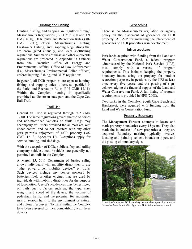
The Management Forester attempts to locate and mark property boundaries every 15 years. They also mark the boundaries of new properties as they are acquired. Boundary marking typically involves locating and painting cement bounds or pipes, and the posting of boundary signs.
Example of a standard DCR boundary marker, shown posted on a tree at Barnstable State Forest. (See Appendix G for information on photo.)

The Nickerson Management Complex
1-23
Buildings and Structures
The management of DCR-owned buildings is performed by DCR employees or contractors. Minor maintenance and repair is performed by on-site staff. More technical repairs (e.g., plumbing, electrical) are performed by DCR in-house trades staff or by trade or engineering contractors whose activities are coordinated through DCR’s Park Support Operation Program. Major repairs are performed solely by licensed contractors.
A five-year High Ground Special Use Permit allows the Massachusetts State Police to place radio equipment and antenna systems at various DCR fire and radio tower locations throughout Massachusetts, including the Barnstable, Falmouth, and Sandwich fire towers. The West Tisbury Fire Tower is not specified in this agreement.
Roads
The DCR maintains and repairs park roads and parkways. Management of traffic and related systems is supervised by the Parkways Section of the DCR’s Engineering Bureau, and guided by American Association of State Highway and Transportation Officials standards; the Manual on Uniform Traffic Control Devices (MUTCD; FHA 2009); and the Historic Parkway Preservation
Treatment Guidelines (DCR 2007b), if applicable. Public roads adjacent to DCR properties are maintained and repaired by either local municipalities or MassDOT.
Snow removal is performed by the DCR, MassDOT, and local municipalities. In general, municipalities or MassDOT plow public roads adjacent to parks and the DCR is responsible for plowing internal park roads.
Parking
The DCR is responsible for maintaining and repairing its parking areas. Most snow removal is performed by the DCR.
Multi-Use Paths
Ongoing maintenance and repair of paved multi-use trails, such as the Cape Cod Rail Trail, are subject to review under MESA and require review by the NHESP.
Trails
A variety of regulations and policies guide the management of trails. The design, management, and marking of trails are guided by the DCR’s Trails
Guidelines and Best Practices Manual (DCR 2012c). In addition, BMPs were recently developed for the closing and restoring of trails and trail maintenance (DCR n.d.d, n.d.e). Trail work is subject to both 950 CMR 70 (Appendix D) and the DCR’s Cultural Resource Policy (Appendix E).
Many trails in the Complex are located within Priority Habitat; all work on these trails must be performed in accordance with guidance and restrictions identified in Recreational Trail
Maintenance and Biodiversity Conservation (NHESP 2009b).
Additional regulations, such as the Massachusetts Wetlands Protection Act may also apply, depending on location. These regulations and policies apply to DCR employee, partner, and volunteer activities. If work is to be performed by volunteers it must also be consistent with DCR volunteer guidelines (DCR 2014).
Kiosks and Signs
The format and placement of regulatory and informational signs are governed by the MUTCD (FHA 2009) and guided by the DCR Graphics
Standards Manual (DCR n.d.f). The design and construction of kiosks are solely governed by the graphics manual.
Informational kiosks are managed by park staff as new information becomes available; they also perform kiosk installation and repair.
Memorials and Markers
The placement or removal of memorials and plaques is prohibited unless authorized by the DCR (302 CMR 12.04(26); Appendix D). Notable markers in the Complex, such as park dedication plaques, are identified in the individual chapters. Other markers, such as memorial benches or gardens, are not identified.

The Nickerson Management Complex
1-24
Example of a park dedication plaque, in this case from South Cape Beach. (See Appendix G for photo information.)
Management Resources
Volunteers
Volunteer activities in parks must be consistent with DCR guidelines (DCR 2014), including completion of a Volunteer/Stewardship Agreement. Additional information on volunteer guidance may be found at: http://www.mass.gov/eea/agencies/dcr/get-involved/volunteer-ops/dcr-volunteer-in-parks-program-guide.html.
1.11. RECOMMENDATIONS
Three priority management recommendations were developed for the entire Nickerson Management Complex. (Table 1.11.1) For a recommendation to be considered priority it must address one or more of the following criteria:
Regulatory compliance or compliance with legal agreements.
Threats to the health and safety of park visitors and employees.
The imminent loss of a natural, cultural, or recreation resource.
Additional maintenance and management needs observed during the preparation of this RMP, but not meeting one or more of the above criteria, are not included in this plan.
The following recommendations are of equal priority.
Table 1.11.1. Priority management recommendations for the Nickerson Management Complex.
Recommendation Implementationa Conduct regular monitoring of properties in which the DCR has a legal interest (i.e., conservation restriction, easement) for consistency with agreements.
P, R, V
Prepare barrier beach management plans for all properties in the Complex with barrier beaches; assess the potential to include all of these properties in a single (i.e., Complex-wide) plan.
P, R
Contact the Office of Cultural Resources before starting any project beyond those described in the BMPs that may impact cultural resources identified in this RMP, especially those in locally designated historic districts.
P, R
a. The following codes identify the party or parties responsible for implementing the recommendations: B = Bureau of Ranger Services; C = Contractor; E = Division of Engineering; F = Bureau of Forest Fire Control and Forestry; L = Legal Services; O = Other; P = Bureau of Planning, Design & Resource Protection; R = Regional and district staff; U = Universal Access Program; V = Volunteer or partner; and X = Office of External Affairs and Partnerships.