second five-year review report michigan disposal … assessment 23 ... (cork street landfill)...
TRANSCRIPT
EPA Region 5 Records Ctr.
1111111111111111111111111111111111111111
376775
Second Five-Year Review Report
Michigan Disposal Service (Cork Street Landfill) Superfund Site
Kalamazoo, Michigan
September 2010
Prepared by:
u.s. Environmental Protection Agency Region 5
Chicago, illinois
Approved by:
'1 ·30 "/1>
Richard C. Karl, Director Date Superfund Division

(This page left blank intentionally)
2
Table of Contents
List of Acronyms 6
Executive Summary 7
Five-Year Review Summary Form 8
I. Introduction 11
II. Chronology of Site Events 11
III. Background 11
Physical Characteristics 11
Land and Resource Use 11
History of Contamination 11
Initial Response 12
Basis for Taking Action 12
IV. Remedial Actions 13
Remedy Selection 14
Remedy Implementation 14
Institutional Controls 14
System Operations/Operation and Monitoring (O&M) 16
V. Progress Since the Last Five Year Review 17
VI. Five Year Review Process 19
Administrative Components 19
Community Involvement 19 Document Review 19
Site Inspection 19
Data Review 20 Interviews 23
VII. Technical Assessment 23
Question A: Is the remedy functioning as intended by 24
the decision documents?
3
Question B: Are the exposure assumptions, toxicity data,
cleanup levels and remedial action objectives
used at the time of remedy selection still valid?
24
Question C: Has any other information come to light that
could call into question the protectiveness of
the remedy?
25
VIII. Issues 25
IX. Recommendations and Follow-up Actions 25
X. Protectiveness Statement 25
XI. Next Five Year Review 26
Tables
Table 1 - Chronology of Site Events
Table 2 - Annual System O&M Costs
Table 3 - Institutional Controls Summary Table
Table 4 - Progress Since Last Five-Year Review Summary
Table 5 - Issues
Table 6 - Recommendation and Follow-up
Figures
Figure I - Moist Area on East Side of Landfill
Figure 2 - Seep Area on East Side of Landfill
Figure 3 - Wetland Mitigation Pond
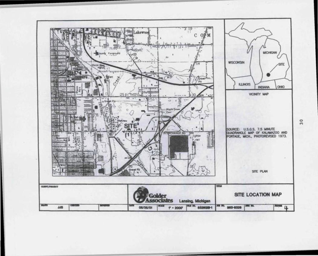
Figure 4 - Site Location Map
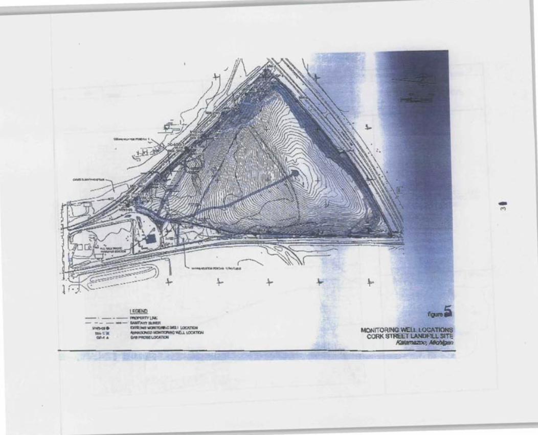
Figure 5 - Site Monitoring Well Locations
4

1
2
3
4
5
6
Attachments
Attachment - Site Maps
Attachment - Deed Restrictions
Attachment - Community Notifications
Attachment - Site Inspection Checklist
Attachment - Interview Survey Forms
Attachment - List of Documents Reviewed
Attachment 7- Site Inspection Photos
5
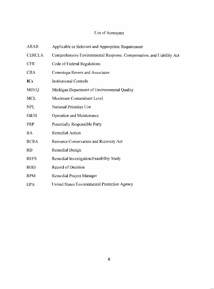
ARAR
CERCLA
CFR
CRA
ICs
MDEQ
MCL
NPL
O&M
PRP
RA
RCRA
RD
RIIFS
ROD
RPM
EPA
List of Acronyms
Applicable or Relevant and Appropriate Requirement
Comprehensive Environmental Response, Compensation, and Liability Act
Code of Federal Regulations
Conestoga-Rovers and Associates
Institutional Controls
Michigan Department of Environmental Quality
Maximum Contaminant Level
National Priorities List
Operation and Maintenance
Potentially Responsible Party
Remedial Action
Resource Conservation and Recovery Act
Remedial Design
Remedial Investigation/Feasibility Study
Record of Decision
Remedial Project Manager
United States Environmental Protection Agency
6
Executive Summary
The selected remedy for the Michigan Disposal Service Superfund Site (the "Site") included recompacting the existing landfill's clay layer, adding a 24-inch protection layer, adding a 6-inch vegetation layer and installing gas vents over a 22-acre portion of the landfill. The remedy also included constructing a new cap over the remaining 30 acres of the landfill consisting of a 6-inch vegetation layer, 24-inch frost protection layer, geosynthetic clay liner and a gas-venting layer. In addition, the remedy modified the leachate collection system, required the installation of monitoring wells for periodic monitoring in accordance with the Groundwater/Surface Water Interface Monitoring Plan, and required the implementation of institutional controls (ICs). ICs include notice to future property owners and recordation of activity and use restrictions in the chain of title for the Site.
The assessment of this five-year review found that the remedy met the requirements of the ROD and the final ROD Amendment. The remedy is functioning as designed. There are no immediate threats and the remedy is protective in the short-term. Long-term protectiveness requires an evaluation of the lateral extent of methane gas migration to determine if a more aggressive landfill gas system is required. An Institutional Control Study Plan (IC Plan) will also be required to ensure implementation of ICs.
7
Five-Year Review Summary Form
SITE IDENTIFICATION
Site name (from WasteLAN): Michigan Disposal Service Superfund Site (Cork Street Landfill)
EPA 10 (from WasteLAN): MID000775957
Region: 5 State: MI City/County: Kalamazoo County
SITE STATUS
NPL status: Final
Remediation status Complete
Multiple OUs?* NO Construction completion date: 09/28/2002
Has site been put into reuse? NO
REVIEW STATUS
Lead agency: EPA Region 5
Author name: Karen Mason-Smith
8
Author title: Remedial Project Manager Author affiliation: EPA Region 5
Review period:" 05/06/2009 to 12/10/2009
Date(s) of site inspection: November 12, 2009
Type of review: Post-SARA
Review number: Second
Triggering action: Previous Five-Year Review Report
Triggering action date (from WasteLAN): December 10, 2004
Due date (five years after triggering action date): December 10, 2009
9
Five-Year Review Summary Form, cont'd_
Issues:
• Analytical data results from the 2009 O&M Report show that elevated levels of methane gas are migrating from the landfill.
• ICs are in place, but need to be reviewed to determine effectiveness_ • MW-4S & M-l have not been sampled since April 2002. • Confirmation sampling is needed to determine if a seep from the landfill is hazardous. • Monitoring wells M-l and W-3 need to be replaced to address zinc exceedances.
Recommendations and Follow-up Actions: • Measure the lateral extent of landfill gas migration. • Prepare and implement an IC Study and Work Plan. • Perform quarterly sampling at monitoring wells MW-4S and M-l. • Perform confirmation sampling of the seep on the east side of the landfill. • Replace galvanized wells M-l and W-·3 to address zinc exceedances.
Protectiveness Statement(s): The remedy is. functioning as designed and is protective of human health and the environment in the short-term. The immediate threats have been addressed adequately_
Long-term protectiveness requires an evaluation of the lateral extent of the methane gas migration to determine if a more aggressive landfill gas system is required.
Long-term protectiveness requires compliance with effective ICs. Compliance with effective ICs will be ensured by implementing effective ICs, which must be maintained, monitored and enforced by developing long-term stewardship procedures as well as maintaining the remedy components at the Site. An Institutional Control Study has been requested from the City to conduct IC evaluation activities. Next, an IC Work Plan will be required (or an IC Plan developed by EPA) to ensure that ICs are effectively implemented, monitored, maintained and enforced.
Date of Last Regional Review of Human Exposure Indicator (From WasteLAN): 07115/2009
Human Exposure Survey Status (from WasteLAN): Current Human Exposure Controlled and Protective Remedy In Place
Date of last Regional Review of Ground Water- Migration Indicator (from WasteLAN): 07115/2009
Ground Water Migration Survey Status (from WasteLAN): Contaminated Groundwater Migration Under Control
10
Michigan Disposal Service (Cork Street Landfill) Superfund Site
Kalamazoo, Michigan Second Five-Year Review Report
I. INTRODUCTION
The purpose of a five-year review is to determine whether the remedy at a site is protective of human health and the environment. A five-year review report documents the methods, findings, and conclusions of reviews. In addition, Five-Year Review reports identify issues found during the review, if any, and identify recommendations to address them.
The Agency is preparing this Five-Year Review report pursuant to the Comprehensive, Environmental Response Compensation, and Liability Act (CERCLA) § 121 and the National Contingency Plan (NCP). CERCLA § 121 states:
If the President selects a remedial action that results in any hazardous substances, pollutants. or contaminants remaining at the site, the President shall review such remedial action no less ofien than each jive years afier the initiation ofsuch remedial action to assure that human health and the environment are being protected by the remedial action being implemented. In addition. (f upon such review it is the judgment ofthe President that action is appropriate at such site in accordance with section [l 04J or [l061, the President shall take or require such action. The President shall report to the Congress a list offacilitiesfor ",·hich such review is required. the results ofall such reviews. and any actions taken from such reviews.
The Agency interpreted this requirement further in the NCP: 40 C.F.R. § 300.430(f)(4)(ii) states:
{fa remedial action is selected that results in hazardous substances, pollutants. or contaminants remaining at the site above levels that allow for unlimited use and unrestricted exposure. the lead agency shall review such action no less often than evelyfive years after the initiation ofthe selected remedial action.
The United States Environmental Protection Agency (EPA), in consultation with the Michigan Department of Environmental Quality (MDEQ), conducted the second five-year review of the remedy implemented at the Site. EPA conducted this review for the Site from May 2009 through September 2010. This report documents the results of the review and inspections conducted at the Site.
This is the second five-year review for the Site. The triggering action for this statutory review is the First Five-Year Review for the Site completed in December 2004. The five-year review is required because hazardous substances, pollutants. or contaminants remain above levels that allow for unlimited use and unrestricted exposure (UU/UE). This review is in the Site tiles and local repositories for the Site.
11
II. CHRONOLOGY
a e 1 ronoI02)' 0 f S'tI e Even s tT bl - Ch Event Date
EPA Proposes Michigan Disposal Service Site to NPL 10/\5/84 Final NPL Listing Feb. 1990 RIIFS 06/0411987 Remedy Selected in Record of Decision 09/3011991 Remedial Design 0611211998 Remedial Action 12/0111999 ROD Amended to eliminate pump and treat 09/25/2002 GroundwaterlSurface Water Monitoring Interface (GSI) Plan 2002 Preliminary Completion Report based on ROD Amendment 09/25/2002 First Five-Year Review Report 12/10/2004 O&M Plan 11117/2004 Gas Probes Installed 06/30/2005 Seep Sampling Work Plan 07/21/2006 Second Five~Year Review Site Inspection 1111212009
III. BACKGROUND
Physical Characteristics
The Site is an inactive landfill located in Kalamazoo County, Kalamazoo, Michigan, and is situated on approximately 68 acres of land. The Site is bounded on the south by Interstate 94, on the west by the Conrail Railroad, on the north by Cork Street and the Lakeside Refinery Co. (a solid waste transfer station), and on the east by Davis Creek and the Grand Trunk Railroad tracks. Davis Creek is not used recreationally.
Land and Resource Use
The immediate area surrounding the property is industrial with the surrounding area exhibiting mixed industrial, commercial and residential land uses. The nearest residences are more than a mile from the Site. The nearest business, Lakeside Refinery Co., is one-quarter of a mile from the Site.
History of Contamination
During its operation from 1925 to 1961, the property was owned and operated by private parties as a general refuse municipal landfill. In 1961, the City of Kalamazoo (City) bought the property and began accepting wastes from local residents, businesses and industries. A tee-pee shaped incinerator, called a Wileo burner, was used to incinerate a majority of the waste with the ash being deposited at the Site. In 1968, the Site became licensed by the state to receive only inert waste, and incineration ceased at the Site to comply with new air pollution regulations. In
12
addition, at that time, the landfill was closed for public use. However, the City continued to dispose of its own inert waste there until 1981. In March of 1981, the City sold the property to Dispos-O-Waste, now known as Michigan Disposal Service Corporation (MDS).
Initial Response
The Site was proposed for the National Priorities List (NPL) on October 15, 1984. On December 3, 1987, the City of Kalamazoo, MDS and the u.S. EPA entered into a Consent Order (EPA Docket No. V-W-87-C-035) for performance of the Remedial Investigation and Feasibility Study (RIIFS). The Site was finalized on the NPL in February of 1990.
The predominant contaminants that were identified during the 1987 RIfFS included heavy metals, volatile organic compounds (VOCs), polynuclear aromatics (PNAs), and several other semivolatile organic compounds (SVOCs). The 1998-1999 groundwater samples yielded detectable concentrations of heavy metals and VOCs.
In July 1991, EPA and MDEQ issued a proposed plan for public comment. The proposed remedy consisted of groundwater extraction and leachate collection with treatment and discharge to the City's publicly owned treatment works (POTW), and closure and containment of the landfilL including installation of a gas venting system, monitoring of groundwater wells, fencing and institutional controls.
On July 17, 1991, EPA and MDEQ held a public meeting in Kalamazoo to solicit comments on the proposed plan. A public comment period was held from July 1 L 1991 to September 8, 1991. EPA and MDEQ responded to both verbal and written comments received on the proposed plan. On September 30, 1991, EPA issued a Record of Decision (ROD), including a responsiveness summary for the Site, which embodied the proposed remedy, as outlined above.
The EPA Amended the 1991 ROD in September 2002. The ROD Amendment relied upon information collected in the pre-design studies, in conjunction with supplemental groundwater quality and stream flow data analysis, which provided data to support changes in the cleanup action for groundwater at the Site. Based on these data, the current Groundwater/Surface Water Interface (GSI) quarterly monitoring, and the June 1995 amendments to Part 201 of Michigan Act 451 , EPA concluded that a feasible response for groundwater at the Site would require monitoring and a periodic re-evaluation of the groundwater discharge across the GSI into Davis Creek.
Basis for Taking Action
In addition to the closure of the solid waste landfill in accordance with solid waste regulations, the 1991 ROD and 2002 ROD Amendment identified the following Remedial Action Objectives (RAOs):
13
• Prevent or reduce the release of contaminants from the landfill into the various environmental media including air, groundwater, surface water and sediment of Davis Creek.
• Ensure that chemical-specific applicable or relevant and appropriate requirements (ARARs) are not exceeded outside the boundaries of the landfill;
• Prevent or reduce off-Site migration of contaminated groundwater; and
• Prevent or reduce the potential risk to human health associated with exposure to contaminated groundwater and/or landfill waste at the Site.
IV. REMEDIAL ACTIONS
Remedy Selection
The final remedy discussed in the ROD, as amended, contains the following components:
• Upgrading the previously capped 22-acre portion of the landfill by re-compacting the clay layer, and by adding a 24-inch protection layer, 6-inch vegetation layer and gas vents;
• Construction of a new cap on the remaining 3D-acre portion of the landfill consisting of 6-inch vegetation layer, 24-inch frost protection layer, geosynthetic clay layer (GCL) and gas venting layer in accordance with MDEQ Standards and RCRA Subtitle 0 cover requirements;
• Land use restrictions to prevent contact with waste and groundwater use restrictions to prevent ingestion of contaminated groundwater:
• Installation of an extension to the leachate collection system;
• Installation of monitoring wells and performance of periodic groundwater monitoring as detailed in the January 2002 Groundwater/Surface Water Interface (GSI) Monitoring Plan. The following contingent remedy for groundwater treatment is also selected for the Site: design and implementation of a groundwater extraction system with discharge to the City of Kalamazoo's POTW if monitoring indicates that there are long-term exceedances in the GSI monitoring wells; and
• Installation of fencing and warning signs to restrict access.
Remedy Implementation
On May 14, 1998, EPA issued a Unilateral Administrative Order (UAO) to the City of Kalamazoo and MDS (the "Respondents") to perform the Remedial Design/Remedial Action (RD/RA) as described in the ROD. Pre-design (pre-RD) field activities began in January 1998. The Respondents completed these activities in January 1999. The work was performed in
14
The Respondents completed these activities in January 1999. The work was performed in compliance with the ROD, the AOC, and in accordance with the Work Plan that EPA and MDEQ approved in October 1997. These studies included vertical profile sampling and monitoring well installation, groundwater sampling and analysis, wetland delineation and sampling, and performance of a groundwater utilization study, waste delineation survey, and predesign report. The purpose of these studies was to develop sufficient data to estimate the horizontal and vertical extent of groundwater contamination at the Site, qualitatively assess potential impacts to public health and environmental receptors of any Site-related contamination, and determine the extent of waste over which the surface cap was to be constructed.
The groundwater studies showed that the quality of groundwater discharging from the Site is not causing an environmental risk to Davis Creek. Groundwater has been impacted due to recharge through landfill waste from the Site. The predominant contaminants that were identified in the 1991 ROD included heavy metals, VOCs, PNAs, and several SVOCs. The 1998-1999 groundwater samples yielded detectable concentrations of heavy metals and VOCs that exceed Generic GSI criteria at monitoring wells located adjacent (i.e. within 20-30 ft) to Davis Creek. Although GSI criteria were exceeded at some monitoring wells that were sampled in 1998 and 1999, new point of compliance monitoring was established in 2001. A Mixing Zone Determination (MZD) was conducted to establish Site-specific GSI criteria to protect Davis Creek, and additional point of compliance wells were installed closer to the creek. Although the GSI criteria have been exceeded at some monitoring points located in the landfill portions upgradient from the creek, the MZD criteria have not been exceeded at point of compliance wells to date, nor is it expected that the MZD standards will be exceeded at the point of compliance wells in the future.
Field activities for construction of the landfill cap began in late April 2000. The landfill cap was completed at the end of June 2002, and its construction included:
• Mobilization and startup, installation of temporary facilities and controls; • Site clearing, grubbing topsoil stripping, and structural demolition; • Waste excavation and relocation; • Paper mill sludge stabilization, implementation of soil erosion and sediment control
measures; construction of a cap upgrade for the 22-acre portion of the landfill, wetland mitigation:
• Multi-layer landfill cap construction for the 30-acre portion of the landfill: grouting of waste below 42-inch sanitary sewer; installation of access roads, culverts, and drainage ditches;
• Passive vent construction; installation of chain link fences and gates; and • Site restoration including seeding and mulching; demobilization from the Site.
Institutional Controls
ICs are required to ensure the protectiveness of the remedy. ICs are non-engineered instruments, such as administrative and legal controls that help minimize the potential for exposure to contamination and that protect the integrity of the remedy. ICs are required to assure the longterm protectiveness for any areas that do not allow for UU/UE.
15
The ROD provides that ICs be imposed, such as deed restrictions, to prohibit the installation of water wells at or near the Site and any future development that might disturb contaminated soils.
Evaluation of Current Conditions, Existing ICs and Planning for Additional ICs, if Necessary
The Site is located in a mixed-use area. Cleanup goals for soil and groundwater allow commercial/industrial use. In accordance with the remedy outlined in the ROD, MDS imposed activity and use restrictions on the Site and recorded them in the chain of title on July 24, 1997 (Attachment 2).
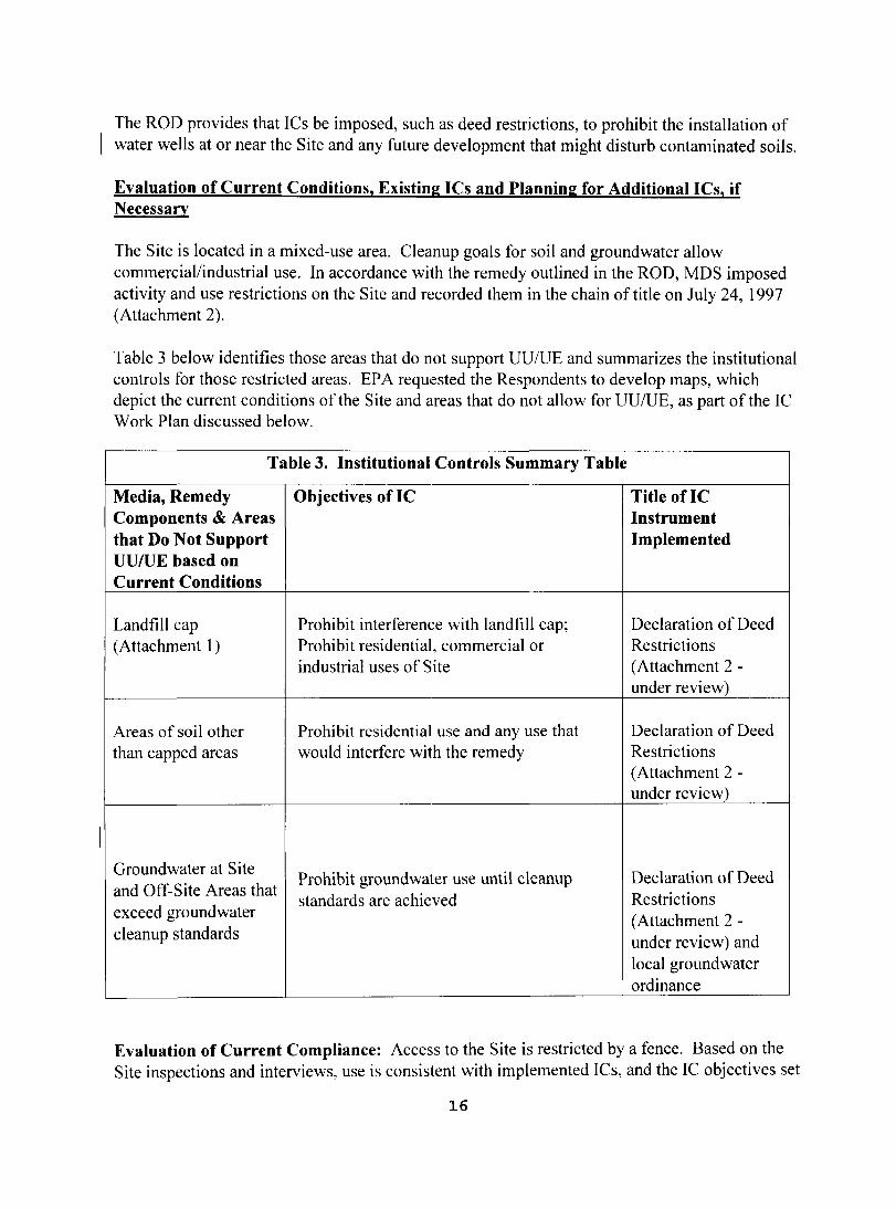
Table 3 below identifies those areas that do not support UU/UE and summarizes the institutional controls for those restricted areas. EPA requested the Respondents to develop maps, which depict the current conditions of the Site and areas that do not allow for UU/UE, as part of the IC Work Plan discussed below.
Table 3. Institutional Controls Summary Table
Media, Remedy Objectives of IC Title oflC Components & Areas Instrument that Do Not Support Implemented UU/uE based on Current Conditions
Landfill cap Prohibit interference with landfill cap; Declaration of Deed (Attachment 1) Prohibit residential, commercial or
industrial uses of Site Restrictions (Attachment 2 under review)
Areas of soil other Prohibit residential use and any use that Declaration of Deed than capped areas would interfere with the remedy Restrictions
(Attachment 2 under review)
Groundwater at Site and Off-Site Areas that exceed groundwater
Prohibit groundwater use until cleanup standards are achieved
Declaration of Deed Restrictions (Attachment 2
cleanup standards under review) and local groundwater ordinance
Evaluation of Current Compliance: Access to the Site is restricted by a fence. Based on the Site inspections and interviews, use is consistent with implemented ICs, and the IC objectives set
16
forth in the ROD.
Evaluation of Long Term Stewardship: Long-term protectiveness at the Site requires compliance with use restrictions to assure that the remedy continues to function as intended. To assure proper maintenance, monitoring and enforcement of ICs, planning for long-term stewardship (LTS) is required. L TS procedures will be reviewed and a corresponding plan will be developed. The plan will include regular inspection of ICs at the Site and annual certification to EPA that ICs are in place and effective. Additionally, use of a communications plan and use of a one-call system should be explored.
Evaluation of Existing ICs and Follow-up Activities
The City of Kalamazoo will undertake an IC Study consisting of specific IC evaluation activities to explore whether the ICs are functioning as intended, to ensure long-term protectiveness of the remedy. The purpose is to evaluate the effectiveness of the existing ICs and determine if additional work is needed to enhance the reliability of them.
The IC Evaluation Activities shall include:
- mapping the Site based on current conditions and identifYing current boundaries of restricted areas associated with the Site and areas which will not allow for UU/UE, (preferably in both paper and GIS format), and evaluation of the physical areas of the recorded deed restrictions to assure that all areas are covered by the ICs;
- evaluating the legal description(s) contained in the existing deed restrictions to ensure it covers the UU/UE areas;
- evaluating property title work to confirm ownership and determine whether some interest, such as a mortgage or utility easement, might defeat the efficacy of the institutional controls;
- evaluating the effectiveness of the current Declaration of Deed Restrictions to ensure it prevents the installation of groundwater wells near the Site;
- evaluating the necessity of the well advisory required by the ROD;
- evaluating the existing Declaration of Deed Restrictions to determine if all objectives are included in an IC and that the IC embodies the appropriate objectives/restrictions;
- evaluating the current Declaration of Deed Restrictions to assure that it is enforceable by City of Kalamazoo; and
- evaluating the long-term stewardship procedures at the Site.
Once the IC evaluation activities have been completed, an Institutional Control Work Plan will be developed by the City of Kalamazoo (and/or an IC Plan prepared by EPA) to incorporate the results of the IC evaluation activities and plan for corrective measures as needed to ensure long
17
term protectiveness of the remedy. The objective of the plan is to ensure that effective ICs are inplace and that the ICs are monitored, maintained and enforced. If sufficient ICs are not in-place or if existing ICs require changes, EPA will request that the Respondents consider new model language that the State of Michigan has been developing in recent months, to ensure that such instruments are enforceable under state law. This model language is in the final stages of development and EPA is evaluating these alternate instruments.
The IC Work Plan will include a schedule and plan for additional IC evaluation activities, if needed, and steps for long-term stewardship to ensure that effective ICs are monitored and maintained.
System Operations/Operation and Maintenance
The City of Kalamazoo is conducting long-term monitoring and maintenance activities at the Site according to the O&M Plan approved by EPA on November 17,2004. O&M activities are expected to continue at the Site for an indefinite period of time that is quantified as thirty years for planning purposes. Site O&M activities, including ground water monitoring and inspections; have been ongoing since the last Five-Year Inspection. A detailed discussion of Site O&M, GSI, wetland/surface water, and landfill gas monitoring is in Section VI of this Five-Year Review. In addition, EPA is reviewing a revised GSI Plan submitted recently by CRA.
Site Operation and Maintenance
O&M activities will continue at the Site for an indefinite period, quantified as thirty years for planning purposes. Site O&M activities, including groundwater monitoring and inspections, have been ongoing since the last Five-Year Inspection.
Consistent with historic practices, future O&M activities will include inspections of the Site, likely performed simultaneously with ground water sampling. The inspections will consist of visual examination of the Site. In particular, the landfill cap will continue to be inspected for settlement, erosion, plants with taproots, and burrow holes. CRA records inspection observations and maintenance recommendations in the field. CRA performs cap and fence maintenance as necessary to maintain cap integrity and limit access to the capped area.
O&M Costs
Table 4 shows the O&M costs. The O&M costs associated with the Site include monthly, quarterly, semi-annual, and annual inspections of the landfill, wetland areas, surface water management structures and ditches; mowing of the grass cover; maintenance; groundwater and surface water sampling; gas probe quality monitoring and landfill gas system maintenance and monitoring. The estimated annual O&M costs vary from approximately $92,000 to $129,000 for routine maintenance. Additional maintenance activities required at the Site, such as fence maintenance or vegetation reseeding, will require an estimated additional expenditure once every five years.
18

Tahie 4: Annua1St,ys em 0'pera fIonsIO&M Cos s t
From 01/2009 0112008 01/2007 01/2006
Date To
Present 12/2008 12/2007 12/2006
Total Cost rounded to the nearest $1,000
92,000 118,000 129,000 114,000
V. PROGRESS SINCE LAST FIVE-YEAR REVIEW
This is the second five-year review for the Michigan Disposal Service (Cork Street Landfill) Site. The first five-year review was completed and signed on December 10, 2004. A status of progress since the last five-year review, with completion dates, is summarized below in Table 5 (See Section VI Five-Year Review Process, Data Review).
19
Table 5 - Progress Since the Last Five-Year Review Summary Summary of Progress Since the Last Five-Year Review for Recommendations/Follow-up Actions
Responsible Party
Oversight Agency
Date Completed
Affects Protectiveness Current Future
I) Continued maintenance of the remedy components and performing five-year reviews to ensure these requirements are maintained. Follow-up: Ongoing
2) PRP addressed the sloughing problems near sedimentation basin No.2 / wetland, by using riprap instead of soil to repair the manmade wetland and prevent this problem from occurring in the future. Follow-up: O&M at the wetland was completed in December 2009 in accordance to the 2004 O&M Plan.
3) PRP addressed the area of moisture on the east side of the landfill and developed a work plan to ascertain if this moisture represents leachate or simply moisture from surface drainage. The 2006 sampling results were below detection levels of GSI criteria. Follow-up: EPA approved a Seep Work Plan on 07/21/06. PRP needs to follow-up with re-implementation of ongoing seep
I sampling.
4) To address the zinc exceedances, PRP replaced wells constructed of galvanized materials with polyvinyl chlorinated (PYC) wells constructed of some other material, which did not contain or contribute to groundwater zinc, or any of the contaminants of concern
I for the Site. Then a period of monitoring for 3 quarters was conducted to determine if zinc levels remained above the generic GSI criterion. Follow-up: Galvanized wells M-l and M-3 need to be abandoned & replaced with PVC wells.
5) Gas probes were installed to monitor whether methane gas was migrating from the landfill. Follow-up: 2009 O&M Monitoring Reports consistently show elevated levels of methane gas above 25% LEL.
6) To address the potential long-term ineffectiveness of the Declaration of Deed Restrictions, it is recommended that an Ie Plan be submitted within 6 months of this fiveyear review. The IC Plan will develop a strategy for obtaining restrictive covenants or easements that run with the land, and thereby, prohibit disturbance of the cap and groundwater use at the Site. Follow-up: EPA submitted an IC Plan request letter to the PRPs in November 2009.
PRPs
PRPs
PRPs
PRPs
PRPs
PRPs
EPA and MDEQ
EPA and MDEQ
EPA
EPA
EPA
EPA
Ongoing
12/2009
Incomplete
Incomplete
06/3012005
Incomplete
N
N
N
N
N
N
Y
Y
Y
Y
Y
y
20
VI. FIVE-YEAR REVIEW PROCESS
Administrative Components
The Michigan Disposal Service five-year review team was led by Karen Mason-Smith, EPA Remedial Project Manager. Cheryl Allen and David Novak, the EPA Region 5 Community Involvement Coordinators; Rich Murawski, EPA Office of Regional Counsel; Mary Schafer, State Project Manager with the Michigan Department of Environmental Quality (MDEQ); Gavin O'Neill and lodie Dembowske, from Conestoga-Rovers and Associates, also assisted in the fiveyear review process for this Site.
The five-year review consisted of a Site inspection and review of relevant documents and interviews. The completed report will be available in the Site information repository, EPA Region 5' s Record Center and the EPA website for public view. The Site repository is located at the Kalamazoo Public Library. This five-year review includes the following components:
• Document Review • Data Review • Community Involvement • Press Release • Site Inspection • Legal Review • Interviews
Community Involvement
The public was notified of the five-year review in December 2009 through a press release and newspaper ad in a local newspaper. No comments were received.
Document Review
The document review analyzed several records, including the following: Record of Decision, ROD Amendment, September 2009 Revised Groundwater Surface Water Interface Monitoring Plan, Operation and Maintenance Plans, GSI Monitoring Reports, and various correspondence (Attachment 5).
Site Inspection
On November 12,2009, Karen Mason-Smith, EPA RPM, conducted the Five-Year Review inspection of the Site accompanied by Mary Schafer and Bill Bolio ofMDEQ, as well as Carolyn Rutland, Mike Wetzel and Bob O'Day of the City of Kalamazoo, and Gavin O'Neill ofCRA.
21
The landfill cap appeared to be in good condition with covered vegetation, and showed no erosion gullies or surface breaks. The fencing around the perimeter of the Site appeared to be in good shape and signs were clearly posted.
The inspection of the Site revealed minor burrowing by animals in several locations on the landfill (Attachment 7). An area along the eastern edge ofthe landfill, adjacent to the area where the old leachate collection trench meets the new leachate collection trench continues to be moist at the surface, as shown below in Figures 1 and 2. Figures 1 and 2 illustrate that the seep discovered during the first five-year review inspection in 2004 is still present today (Attachment 7).
Figure 1 - Moist area along eastern collection leachate edge of trench (October 2004)
Data Review
Ground Water and Surface Water Monitoring
Figure 2 - Road with seepage near leachate collection trench (October 2004)
Quarterly GSI monitoring has been performed at the Site since 1998 pursuant to the GSI Monitoring Plan. GSI monitoring activities were performed most recently in June and September 2009. The GSI monitoring activities include groundwater and surface water sampling and taking surface water and static ground water level measurements.
Consistent with historic practices, long-term ground water monitoring will continue to be performed at the Site through the collection of ground water samples from a network of monitoring wells. GSI sampling locations pursuant to the approved 2002 GSI Monitoring Plan consist of 16 monitoring wells at 10 locations, including 5 well pairs and/or clusters. Of the 16 wells, 10 required quarterly monitoring in the shallow zone and 6 required annual monitoring in the deep zone.
Wetland and Surface Water Monitoring
Wetlands were created as part of the landfill closure and have been monitored consistent with the approved 2004 O&M Plan to evaluate the success of the wetland mitigation activities and to assess impacts to the long-term integrity of the wetlands. Bailey Contractors completed
22
construction of the wetland in fall 2004, as illustrated below in Figure 3.
The O&M Plan required monitoring and maintaining the wetlands for five years. The 5-year monitoring period commenced in fall 2004. No further monitoring of the wetlands is required following December 2009, which was the fifth and final monitoring period. The November 2009 five-year review revealed that the wetland mitigation pond is functioning successfully and wildlife, including an egret, utilized it (Attachment 7).
Figure 3 - Wetland Area and Sedimentation Pond No.2 (October 2004)
Site Operation and Maintenance
Inspections of the landfill are conducted on a quarterly basis. Areas throughout the landfill are checked to ensure the various components of the landfill cover system are operational. As the Responsible Party, the City of Kalamazoo 's contractor, CRA, performs required quarterly inspections in accordance with the approved 2004 O&M Plan. The most recent quarterly O&M reports submitted to EPA provides results from inspections at the Site conducted in June and September 2009, during the second five-year review period. These efforts consisted primarily of inspection and general upkeep of the consolidation area.
The cap has been, and will continue to be, examined for settlement, erosion, plants with taproots, and burrow holes. Inspection observations and maintenance recommendations will continue to be recorded in the field .
Seep on East Side of Landfill
The area of moisture on the east side of the landfill along the access road could possibly be from a minor leachate outbreak given its proximity to the "old" leachate collection trench that stops just adjacent to the "new" leachate collection trench. EPA approved a Seep Sampling Plan on July 2006. CRA collected seep samples in December 2006, including three samples from shallow trenches excavated along the toe of the slope immediately west of the eastern access road
23

and two samples from leachate collection manholes (i.e., MH-G#4). The analytical results were compared to Michigan Part 201 generic GSI criteria, which are conservative and protective of Davis Creek. Davis Creek would be the receptor if the seep were to flow or migrate off-Site. The 2006 seep analytical results were below GSI compliance criteria, and do not pose a hazard to human health or the environment. However, EPA recommends that the City of Kalamazoo continue to monitor the seep.
Landfill Gas System Maintenance and Monitoring
Landfill gas (LFG) system maintenance and gas probe quality monitoring is also conducted at the Site. LFG and barhole sampling was completed in April 2006 at Lakeside Refinery Co., which is a solid waste transfer station that is adjacent to the Site, due to elevated readings in the gas probes. Lakeside Refinery Co. is located in trailers that sit on concrete slabs. The LFG sampling results from the trailers were below levels of concern and considered non-hazardous. The sampling results were presented in the O&M Progress Report dated July 2006. The City of Kalamazoo maintains that the results of the 2006 LFG sampling support its position that methane gas is not migrating off-site.
Gas monitoring of the eight gas probes at the Site was completed by CRA on June 22, 2009 and September 23,2009. Monitoring is conducted for the existing gas probes and manholes along the sanitary sewer lines at the landfill. During the June 2009 gas-monitoring event, detectable levels of methane were reported at MH-3 and MH-4 along the sanitary line, and along the leachate collection system at MH-H#l, MH-G#2, MH-G#3 and MH-G#4.
In September 2009, methane levels exceeded 25 percent of the lower explosive limit (LEL) at three of the gas probes (GP-3, GP-4 and GP-8) located along the northwest and east edges of the landfill. Methane levels ranging from 0.0 to 57.3 percent by volume were reported. Carbon dioxide readings ranging from zero to 18.9 percent by volume were recorded while oxygen readings ranging from zero to 15.1 percent by volume were recorded.
Migration potential is considered possible if methane concentrations, in excess of 25 percent of the LEL for methane (1.25 percent by volumt:) in monitoring probes, are found outside the limit of the refuse. The limit of the refuse is close to the perimeter of the Site.
The extent of the methane gas migration from the landfill will need to be evaluated further in order to determine whether the landtill gas is migrating laterally, and to ensure that the remedy is operating properly and successfully. In addition, EPA recommends that more information be collected to deternline if a more aggressive LFG monitoring plan is needed.
Groundwater/Surface Water Interface (GSI) Monitoring Plan
The GSI Monitoring Plan does not give a standard for zinc, although zinc was detected in the past above Generic GSI criteria in monitoring wells constructed of galvanized materials. MDEQ provided site-specific Mixing Zone Determination (MZD) criteria of 1200 /lg/L for zinc. Several of the galvanized monitoring wells were abandoned and replaced with PVC wells in 2006 that currently do not show zinc results. It should be noted that due to the steep slopes around
24
monitoring wells M-l and W-3, these galvanized wells were not replaced. Monitoring well W-3 has been monitored in the quarterly sampling events for the Site.
It should be noted that monitoring wells M-l and MW -4S have not been sampled since April 2002. Quarterly sampling of M-l and MW -4S will be conducted until sufficient data is collected to justify reduced monitoring.
Unionized Ammonia Monitoring
Unionized ammonia was detected in eight of the ten monitoring wells where samples for nitrogen ammonia were collected during the September 2009 sampling event. Although the 1999 OSI Monitoring Plan did not provide standards for unionized ammonia, MDEQ calculated Sitespecific MZD criteria of 680 ug/L for unionized ammonia, using the pH and temperature of the receiving water body. The unionized ammonia values calculated by CRA were below the Final Acute Value (FAV) obtained from the Michigan Rule 57 Water Quality Values. If a constituent's concentration in any well exceeds the FA V, a confirmational groundwater sample for the constituent(s) of concern will be collected within three weeks of validation of the analytical data. If the confirmatory sample contains the constituent at a level below the FA V, subsequent sampling will default back to the normal monitoring frequency that is specified in the OSI Monitoring Plan.
Interviews
The EPA RPM conducted interviews with Oavin O'Neill (CRA Project Manager), Mary Schafer (MDEQ Project Manager) and Carolyn Rutland (City of Kalamazoo Project Manager), for purposes of this Five-Year Review (Attachments 4 and 5).
VII. TECHNICAL ASSESSMENT
Question A: Is the remedy functioning as intended by the decision documents?
Yes. Nothing observed at the Site would be an imminent threat to the integrity of the cap in the short-term and the fence around the Site is in good condition.
Regarding ICs, a local ordinance restricting groundwater use and a Declaration of Deed Restrictions are in place. Based on inspections, review of monitoring data and interviews with local officials, there appears to be compliance with land and groundwater use restrictions.
Question B: Are the exposure assumptions, toxicity data, cleanup levels, and remedial action objectives used at the time of the remedy selection still valid?
Yes. There have been no changes in the physical conditions of the Site that would affect the protectiveness of the remedy.
25
Changes in Standards and Things to be Considered
The Federal Drinking Water Criteria or Maximum Contaminant Level (MCL) for arsenic has been changed. The arsenic MCL change does not affect the Site directly.
Question C: Has any other information come to light that could call into question the protectiveness of the remedy?
No. There is no other information that calls into question the protectiveness of the remedy in the short-term. There is new information that may call into question the protectiveness of the remedy in the long-term. Current data from gas probes at the Site indicate methane gas is migrating from the landfill at elevated levels. The lateral extent of landfill gas migration will need to be determined.
VIII. ISSUES
Issues identified in this five-year review are listed below in Table 5.
Table 5 - Issues Issues Affects Current
Protectiveness (YIN) Affects Future Protectiveness (YIN)
1) Seep on the east side of the landfill continues to produce moisture in this area from surface drainage. Confirmation is needed to determine if it is still a non-hazardous liquid or leachate.
N Y
2) Galvanized monitoring wells M-I and W-3 need to be replaced to address zinc exceedances.
N Y
3) O&M Monitoring Reports consistently show elevated levels of methane gas from the landfill above 25% of lower explosive limit (LEL).
N Y
4) ICs are in place but need to be reviewed to determine effectiveness.
N Y
5) Monitoring wells M-l &
MW -4S have inadvertently not been sampled since April 2002.
N Y
26
IX. RECOMMENDATIONS AND FOLLOW-UP ACTIONS
Table 6 below lists the primary recommendations and follow-up actions for this second five-year
review. In addition, using the EPA-approved July 21, 2006 work plan, EPA recommends that the PRPs continue to monitor the seep on the east side of the landfill to ascertain if this seep represents leachate or moisture from surface drainage. Monitoring wells M-I & MW -4S, which have not been sampled since April 2002, should also be monitored on a quarterly basis until sufficient data is collected.
Table 6 - Recommendations and Follow-up ActIOns
Recommendations/Follow-up Actions
I) Replace galvanized wells (M-I and W-3) with wells constructed of some other material. which will not contain or contribute to groundwater zinc, or any of the contaminants of concern for the Site. A period of monitoring for 3 quarters will need to be conducted to determine if zinc levels have remained above the generic GSI criterion. If the criteria are exceeded, contingency actions as described in the ROD Amendment should be performed.
2) Evaluate data from LFG monitoring probes to determine the lateral extent of methane gas migration and whether a more aggressive remedy for LFG is needed.
3) To address the potential long-term ineffectiveness of the deed restrictions recorded at the Site:
(a) an Ie Study shall be completed and submitted to EPA for review and approval within seven months of this five-year review;
(b) an Ie Work Plan will be submitted within one year of this five-year review. The Ie plan will develop a strategy for obtaining restrictive covenants or easements that run with the land and thereby prohibit disturbance of the cap and groundwater use at the Site.
Responsible Party
PRPs
PRPs
PRPs
PRPs
Oversight Agency
EPA
EPA
EPA
EPA
Milestone Date
03/30/11
06/30/11
04/30111
09/30/11
Affects Protectiveness
\Current Future
N y
N y
N y
N y
27
X. PROTECTIVENESS STATEMENT
The remedy is considered protective in the short-term. There is no evidence of a landfill cap breach, groundwater use, or exceedance of GSI standards. The remedy is expected to be protective of human health and the environment in the long-term upon attainment of groundwater cleanup goals, through performing groundwater monitoring utilizing GSI criteria and implementation of a groundwater extraction system with discharge to the City of Kalamazoo's POTW, if monitoring indicates there are long-term exceedances in the GSI monitoring wells.
Gas probes have been installed since the last five-year review, and there is current data, which positively affirms that landfill gas is escaping from the landfill at substantial concentrations at or near the property boundary. Analytical data results from landfill gas monitoring events showed elevated levels of methane that exceeded 25 percent of the lower explosive limit (LEL) at two of the gas probes (GP-2 and GP-3) in June and September 2009 (CRA, September 2009; October 2009). In order for the remedy to be demonstrated to remain protective in the long-term, the PRPs must evaluate the lateral extent of landfill gas migration needs to determine if a more aggressive landfill gas system is required.
Long-term protectiveness requires compliance with effective ICs. Compliance with effective ICs will be ensured by implementing effective lCs, which must be maintained, monitored and enforced by developing long-term stewardship procedures as well as maintaining the site remedy components. An Institutional Control Study has been requested from the City of Kalamazoo to conduct IC evaluation activities to determine if the ICs are functioning as intended to ensure long-term protectiveness of the remedy. Once the IC evaluation activities have been completed, an Institutional Control Work Plan will be required from the City of Kalamazoo to plan for any corrective measures to ensure long-term protectiveness of the remedy.
XI. NEXT FIVE-YEAR REVIEW
The next five-year review will be completed five years from the signature date of this document.
28

ATTACHMENT 1 - SITE MAPS
29
VICINITY MAP
o C"'l
SOURCE: U.S.C.S. 7.5 t.AINUTE QUADRANGLE t.4AP OF KAl..At.AAZOO AND
ORTAGE, t.AICH., PHOTOREVISED 1973.
SITE PLAN
SITE LOCATION MAP
110.110. .a.a.tOIIHI01
(~" )H-..t:'f1';.(I"lj6f ll'CM'lrk i' (tlt~:MD
II:GENO --' - - -- F9IOPER'TY LI.... - - - - -- BANrr"l" IiCWER
.Y~5. at~IIoI(!_111l""CM11 Loa..'T1CiN 1M. C ~1Xl"F-1l.·AONI1CIIIHG V'E..J. LO:\l,11Q\j MONITORING WEll. LOQA.TIONS. QII..4 .. GI\'5 PROBE L.OC~nON CORK S' tEE I LNIlFU.SITI:
~~

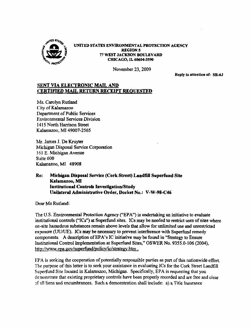
ATTACHMENT 2 - IC STUDY REQUEST LETTER AND DEED RESTRICTIONS
32
UNITED STATES ENVIRONMENTAL PROTECTION AGENCY REGIONS
77 WEST JACKSON BOULEVARD CHICAGO, IL 60604-3590
November 23, 2009 Reply to attention of: SR-6J
§ENT VIA ELECTRONIC MAIL AND ~:::ERTIFIED MAIL RETURN RECEIPT REOUESTED
Ms. Carolyn Rutland City of Kalamazoo Department of Public Services Environmental Services Division 1415 North Harrison Street Kalamazoo, MI 49007-2565
Mr. James J. De Kruyter Michigan Disposal Service Corporation 161 E. Michigan Avenue Suite 600 Kalamazoo, MI 48908
Re: Michigan Disposal Service (Cork Street) Landfall Superfund Site Kalamazoo, MI Institutional Controls Investigation/Study Unilateral Administrative Order, Docket No.: V-W-98-C46
Dear Ms Rutland:
The U.S. Environmental Protection Agency ("EPA") is undertaking an initiative to evaluate institutional controls ("ICs") at Superfund sites. ICs may be needed to restrict uses of sites where on-site hazardous substances remain above levels that allow for unlimited use and unrestricted exposure (UUIUE). ICs may be necessary to prevent interference with Superfund remedy components. A description ofEPA's IC initiative may 1;>e found in "Strategy to Ensure Institutional Control Implementation at Superfund Sites," OSWER No. 9355.0-106 (2004), httm' /www.epa.gov/superfundlpolicY/ic/strategy.htm .
EPA is seeking the cooperation ofpotentially responsible parties as part of this nationwide effort. The purpose of this letter is to seek your assistance in evaluating ICs for the Cork Street Landfill Superfund Site located in Kalamazoo, Michigan. Specifically, EPA is requesting that you de:nonstrate that existing proprietary controls have been properly recorded and are free and clear of alltiens and encumbrances. Such a demonstration shall include: a) a Title msurance
Commitment using ALTA Commitment F onn 1982 as amended "for infonnation only purposes" by a title company; b) copies ofdocuments referenced in the title commitment; c) copies of the existing proprietary controls showing the recording stamp; d) copies ofencumbrances, utility right ofways, leases and subleases impacting restricted areas; e) map and geographic infonnation system (GIS) infonnation that identifies parcel numbers and boundaries of current encumbrances (such as utility easements) that impact restricted areas; and f) copies of subrogation agreements for encumbrances.
Please provide EPA with a notice of intent to comply with this request within 7 business days of the date of receipt of this letter. Ifyou have any questions concerning this request, please contact Karen Mason-Smith, Remedial Project Manager, at 312-886-6150. Legal questions may be directed to Richard M. Murawski, Assistant Regional Counsel, at 312-886-6721. Thank you for your attention to this matter.
Sincerely,
'4<iUuL'rY\~-U Karen Mason-Smith Remedial Project Manager
(g1~<f~O~~u"'SiAi L Of- M1CHtGAN Ml J
U8ER1946 0137 CO{lNTY Cr- KALAMAZOO R£C[IV~:_' ;- JR RECORD
022128 A'l'T,('mmrr IV '97 JUL 2lf PM· 2 5~
1\- Q(.frr.:fiCtiQDII gt!ftNt'f.:.'::::lst~ d-
CLERK - REGISTER Michigan Disposal Service Corporation, owner in fee aillple of the real estate described below, hereby imposes restriction. on the described real estate, also known as the Michigan Dispoaal Service (Cork Street) Landfill Superfund Slte (hereafter "the Site") in Kalamazoo, Kalamazoo COUllty, State of Michigan:
It. parcel of land in Section 36, Town 2 South, Rana- 11 Weat, City of Kalamazoo, C01D1ty of Kalamazoo, Michigan beiD.& more particularly described as folloys:
COlDIDencin& at the Northwest Corner of Section 36, Town 2 South, RlllIe 11 West; Thence R89-47'23"! on· the North Line of Section 36 1507.89 Feet (Recorded as 1533.03 Feet) to its Intersection with the Weat Line of the Grand Trunk and Western RaUroad; Thence Southeaaterly on the Weat Line of the Grand TI'1JDJt aDd Weatern RaUroad on a CUrTe to the left 34.20 feet (Recorded as 34.23 feet), saiel curve haTina a raelius of 1546.49 feet, a central anale 01-16'02", aDd a chord of SI5-26'S8"1 34.20 feet,· to the South Line of Cork Street aDd the place of belinnin& of thia deacription; thence continuina Southeaaterly on the Weaterly line of the Grand Trunk and Weatern Railroad on a curve to the left 712.52 feet (Recorded aa 718.24 feet), said cane haTl1l.& a radius of 1546.49 feet (Recoreled as 1563.49 feet), a ceDtral anale 26-23'52", and a chorel of S29-23'55"1 706.23 feet (Recordeel as 528-41'37"! 745.23 feet); thace S42-28'5l"! on the West Une of the Grand Trunk and We.tem Railroad 1575.94 feet (Recorded .. S42-28'52"1 1569.88 Feet); thence S03-12'46"W on the West line of the Grand Trunk and Western Railroad 23.76 feet (Recordeel as S03-57'37~ 23.46 feet); thence 542-28"51"E on the West line of the Grand Trunk and Western Railroad 252.76 feet to the Northerly line of Biahvay 1-94 (Recorded as 542-28'50"! 254.03 feet more or lesa) i thence S45-38"10"" on the North Une of Biahway 1-94 201.36 feet (Recorded as S45-36'38"W 240.39 feet more or leaa); thence Westerly on the ~orth line of Biahvay 1-94 ou a CUrTe to the Richt 887.96 feet (Iecorded a. 974 feet more or Ie••). said CurTe haTtna a radius of 5579.65 feet (Re~orded a. 5579.58 feet), a central anale 9-00'56-, and a chord of S50-08'38"" 887.05 feet; thace S35-20'54"1 on the Irorth Une of Bllhway 1-94 50.00 feet, thence We.terly on the Rorth line of Biahvay 1-94 on a CUrTe to the riaht 941.41 feet (Iecorded •• 720.13 feet), said curve haY-ina a raelius of 5629.65 feet (Iecorded a. 5629.58 feet), a central anale of 9-34'~2", and • chord of 559-26'32"W 940.31 feet; thence 564-13'58"W on the Borth line of Hi&hvay 1-94 47'.91 feet (Recorded aa 564-19' 38~' 42.42 feet) to the Eut line of the ConraU RaUroad; thence NOO-17'50"W on the East line of the Conrail Railroad 1396.91 feet (Recorded a. ROO-17'52"W 1399.12 feet); thence Northerly on the East Une of the Conrail RaUroad on a curve to the Left "728.89 feet (Recorded .s 719.58 feet), said curve haTina a radius of 3911.15 feet (Recorded as 3869.77 feet), a central anale 10-40'40", and a chord of

lIB£R1946 0138
ROS-38'10"W 727.83 feet (Recorded as NOS-37'29"W 718.55 feet); thence KIO-S8'30"W on the· East line of the Conrail RaUroad, 219.36 feet, thence K89-32'26"Z 133.91 feet, thence N70-26'35"Z 107.67 feet, thence lI51-I7'l7"1 97.23 feet, thence H20-4S'19"Z 123.22 feet, thence ROO-39'02"W 107.18 feet, thence R26·37'36"W 138.32 feet, thence NI2-44'IJ"W 176.13 feet, thence R14-09'44"W 287.34 feet to the place of beginning.
This parcel contains 59.736 acres, more or leas. Subject to all easements and restrictions of record.
The (ollowing restri.ctions are imposed upon the Site, ita present and any future owners (includina heirs to the above described real estate), their authorized agents, a••igna, employees, or persona actina under their direction or cODtre)l, for the purposes of protectina public health or welfare and the environment, preventing interference with the perfol'1llaDce, and maintenance, of any response actions selected and/or undertaken by the United States Environmental Protection Agency ("U.S. EPA"), or any party acting as agent for the U.S. EPA, pursuant to Section 104 of the Comprehensive Envir·onmental Response, Compensation, and Liability Act ("CERCLA."). Specifically, the following deed restrictions shall apply to the SIte as provided for in paragraph nine (9) of the Consent Decree:
1. There shall be no consumptive or other u.. of the groUDdwater underlyina the SIte that could cause exposure of huaana or animals to the groundwater underlying the SIte;
2. There shall. be no residential, co_ercial, or agricultural use of the SIte, including, but not 11.Jllited to, any on-site excavation, landfilliD.l., adning, invaalve construction, drillina. and installation of drinking water production wells, except a. approved by U. 5. ZPA. ;
3. There ahall be no use of the Site that would allow the continued presence of humans at the Site, other than the presence necesaary for the implement.ation of any response actions selected and/or undertaken by U.S. EPA pursuant to Section 104 of CERCLA, including such response actions taken by other responsible parties under a judic!d 0:- ad:inistntive order. A ~rehibited use of the Site includes, but is not limited to, recreational use;
4. There shall. be no installation, removal, construction or use of any buildings, wells, pipes, roads, ditches or any other structures or materials at the Site except as approved, in writing by U.S. BPA;
5. There shall be no tamperina with, or removal of, the contaiDllleDt or monitoring syatems that remain on the Site as a result of implementation of any response action by U.S. EPA, or &nJ' party acting as agent for U.5. EPA, and which is selected and/or undertaken by U.S. EPA pursuant to Section 104 of CERCLA; and
-2
i
Lf~fR 1946 01.39
6. !here ahall be no use of, or activity at, the Site that ma., interfere with, dUlace, or otherwise impair the effectiveness of any response action (or component thereof) selected and/or undertaken by U.S. EPA, or any party actina a. alent for U.S. EPA, pursuant to Section 104 of CERCLA, except with written approval of u.s. EPA, and consistent with all statutory and relulatory requirements •
'I'he obUgation to implement and maintain the above restrictions shall nm 'lith the land and shall remain in effect until such tille a. U.S. EPA files 'lith the Court a written cenificadon Btstine the above restrictions are no loncer necessary to meet the purposes of this Decree.
Ilf WITl'fESS WHEREOF, Mi..d"Iigm 0ifJ!i& ~-nnl!Aatial· ha. caused these Deed Reacrictions to be executec1 the // day of ~ 1993.
A2608J
a DRAFTED BY:
Gary-A. Trepod HUBBARD, FOX ,THOMAS,
WHITE &BENGTSON, P.C. 5B01 W. Michigan Avenue Lansing, Michigan 48908-0857 (517) 886-7122
Subscribed and sworn to before me this 10th day of July. 1997.
--L_._-=---¥----=a~.__Y__=__A~ Gary A. T InHham C Act;ing in Eaton County, Michigan My Conrnission Expires: 11/18/2000
ty, Michigan
-3

·olhoioo HON 17: 12 FAX 517 886 5,292 GARY TREPOD IaJ 002
028897 (" -t. T·· . - ,. •Ll8ER2046 rC1160 y I ': U; 1··ll, Hie I~ :.~ COUNTY OF K..:';LMo!I.lQO
UNITED STATES ENY.IRONMENTAL PROTEC'litQi( I~ REC 0 R 0 REGION V
t \1-~. 'S8 JUL 9 ArJ 9 25d- Its.l1)
In the Matter of: '- ,.
Michigan Oisposal (Cork Street Landfill) Superfund Site
City of Kalamazoo Michigan Disposal Service Corporation and Michigan Oi~posal Service Corporation Liquidating Trust
. Docket RD. V-W-98-C-464
Proceeding Under Section 106(a) of the Comprehensive Environmental Response, Compensation, and Liability Act of 1980, as amended (42 U.S.C.§ 9606(a))
NOTICE OF UNILATERAL ADMINISTRATYVE ORDER FOB. REMEDIAL DESIGN AND REMEDIAL ACTl:ON
Notice is hereby given that a Unilateral Administrative.... ,.
Order for Remedial Design and Remedial Action was issued on May
14, 1998, by the United States Environmental Protection Agency
regarding toe following property located in the City of
Kalamazoo, County of Kala~azoo, Michigan:
CommenCing at the Northwest Corner of Section 36, Town 2 South, Range West; Thence N89°41'23"E on the North Line of Section 36 1507.89 Feet (RecordE:~d as 1533.03 Feet) to its Intersection with the West Line of the Grand trunk and Western Railroad; Thence Southeasterly on the West Line of the Grand Trunk and Western Railroad on a curve to the left 34.20 feet (Recorded as 34.23 feet), said curve having a radius of 1546.49 feet, a central angle 01°16'02", and a chord of SlSu26'58 H E 34.20 feet, to the South Line of Cork Street and the place of beginning of this description; thence continuing Southeasterly on the Westerly line of the Grand Trunk and western Railroad on a curve to the
,-' left 712.52 feet (Recorded as 718.24 feet), said curve having a
:. o.lhoioo MON 17: 13 FAX 517 888 5292 GARY TREPOD raJ 003
"
tllER2046 rC1161 [",3.dius of 1546.49 feet (Recorded as 1563.49 feet), as central angle 26°23'52", and a chord of S29D23'55~E 706.23 feet (Recorded as S28D41'37~E 745.23 feet); thence 542°28'51"£ on the West line of the Grand Trunk and Western Railroad 1575.94 feet (~ecorded as S42°28,'S2"E 1569.BB Feet); thenca S03 Q 12'46"W on the West line of the Grand Trunk and Western Railroad 23.76 feet (Recorded as S03 DS7'37"W 23.46 feet); thence S42°28'51"E on the WI3st line of the Grand Trunk and Western Railroad 252.76 feet to the Northerly line at Highway I-94 (Recorded as S42°2B'SO"E 254.03 feet more or less); thence 545°38'10"W on the North line of Highway 1-94 201.36 feet (Recorded as S4S a 36'38"W 240.39 feet more or less); thence Westerly on the North line of Highway 1-911 on a curve to the Right 8B7.96 feet (Recorded as 974 feet more or less), said curve having a radius of 5579.65 feet (Recorded as 5579.58 feet), a central angle 9 DOO'56", and a chord of S5000B'3S"W 887.05 feet: thence S3S D20'54"E on the North line of Highway 1-94 50.00 feet, thence Westerly on the North line of.' Highway 1-94 on a curve to the right 941.41 feet (Recorded as 720.13 feet), said curve having a radius of 5629.65 feet (Recorded as 5629.58 feet), a central angle of 9°34'52", and a chord of S59°26'32"W 940.31 feet; thence S64°13'58 u W on the North line of Highway 1-94 47.91 feet (Recorded as S64°19'38 u w 42.42 feet) to the East line of the Conrail Railroad; thence NOOo11'50"W on the East line of the Conrail Railroad 1396.91 feet (Recorded as NOO D 17'52 n W 1399.12 feet); thence Northerly on the East line of the Conrail Railroad'on'a curve of the Left 72B.89 feet (Recorded as 719.58 feet), said curve having a radius of 3911.15 feet (Recorded as 3869.77 feet), a central angle 10°40'40", and a chord of NOSD38'lO"W 727.83 feet (Recorded a N05 D 37'29 N W 718.55 feet): thence NIO D58'3C"W on the East line of the Conrail Railroad, 219.36 feet, thence N89 D 32'26"E 133.91 feet, thence N70026'35"E 107.67 feet, thence W31°17/J7"E·~·n.23 feet, thence N20 D 45'19"E 123.22 reet, thence.· NOOo39'02"W 107.18 feet, thence N26 D37'36"W 138.32 feet, thence N12 D 44'13"W 176.13 feet, thence N14°09'44"W 297.34 feet to the place of beginning.
This parcel contains 59.736 acres, more or less. Subject to all easements and restrictions of record.
. " ~Ol/10100 MON 17:13 FAX 517 886 5292 GARY TREPOD IlJ004
.... "
. - --2046 fG1162 WITNESSES:
Subscribed and sworn before me t 6th day of uly, 1998 .
.... "
Foreman, Notary Public Ingham County acting in Eaton, Michigan My Commission Expires: 6/21/2000
PREPARED BY:
Gary Trepod (P21561) HUBBARD, FOX, THOMAS, WHITE &: BENGTSON, P. C'. 5801 W. Michigan Avenue Lansing, Michigan 48908-0857 (517) 886-71:)2
KMF;LIT:Mi diapOaal .o~1~.-doc
.... "

ATT ACHMENT 3 - COMMUNITY NOTIFICATIONS
33

EPA To Review :\1ichigan Disposal Services
(Cork Street) Landfill Kalamazoo, Kalamazoo County, Michigan
u.S. Environmental Protection Agency is reviewing the effectiveness of the cleanup selected for the Michigan Disposal Services (Cork Street) Landfill Superfund site. Superfund law requires regular five-year reviews either of sites where the cleanup is done or in progress, but hazardous waste remains on-site. These five-year-·reviews are done to ensure that the cleanup remains effective and is protective of human health and the environment.
At the Michigan Disposal Services Site, EPA selected capping (covering) the site and monitoring the contaminated ground water as the cleanup method. Contaminants of concern at the site included volatile organic compounds, toluene, xylene, benzene and heavy metals such as arsenic and lead. A nearby creek showed elevated levels of lead and iron.
As part of this five-year review EPA will look at:
Site information, How the cleanup was done, How well the cleanup is working, and What are the future actions at the Site?
This review is currently underway, the results of which will be placed in the:
Kalamazoo Public Library 315 S. Rose Street Kalamazoo, Mich.
For questions or concerns regarding the cleanup remedy or the review, please contact the following person:
Karen Mason-Smith Remedial Project Manager
U.S. EPA, Region 5 (SR-6J) 77 W. Jackson Blvd. Chicago, IL 60604
(312) 886-6150
34

ATT ACHMENT 4 - SITE INSPECTION CHECKLIST
35
- -
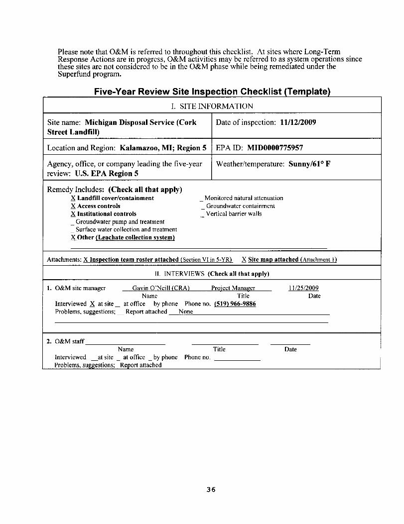
Please note that O&M is refern!d to throughout this checklist. At sites where Long-Term Response Actions are in progress, O&M activities may be referred to as system operations since these sites are not considered to be in the O&M phase while being remedtated under the Superfund program.
Five-Year Review Site Inspection Checklist (Template)
I. SITE INFORMA nON
Site name: Michigan Disposal Sf'rvice (Cork Date of inspection: 11112/2009 Street Landfill)
Location and Region: Kalamazoo, MI; Region 5 EPA ID: MIDOOO0775957
Agency, office, or company leading the five-year Weather/temperature: Sunny/61° F review: u.S. EPA Region 5
Remedy Includes: (Check all that apply) X Landfill cover/containment Monitored natural attenuation X Access controls
-Groundwater containment -
X Institutional controls Vertical barrier walls -_ Groundwater pump and treatment
Surface water collection and treatment -
X Other (Leachate collection system)
Attachments: X Ins~ection team roster attached (Section VI in 5-YR) X Site ma~ attached (Attachment I)
II. INTERVIEWS (Check all that apply)
1. O&M site manager Gavin O'Neill (eRA) Project Manager \\/25/2009 Name Title Date
Interviewed X at site _ at office _ by phone Phone no. (519) 966-9886 Problems, suggestions; _ Report attached None
2. O&M staff Name Title Date
Interviewed at site at office _ by phone Phone no. Problems, suggestions; Report attached
36
I
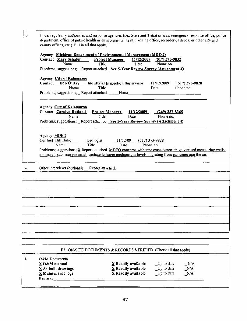
J. Local regulatory authorities and response agencies (i.e., State and Tribal offices, emergency response office, police d(~partment, office of public health or environmental health, zoning office, recorder of deeds, or other city and county offices, etc.) Fill in all that apply.
Agency Michi2an Del!artment of Environmental Mana2ement {MDEQ} Contact Mary Schafer Project Mana2er 11112/2009 {517} 373-983~
Name Title Date Phone no. Problems; suggestions; _ Report attached See 5-Year Review Survey {Attachmentll
Agency City of Kalamazoo Contact
Problems;
Bob O'Day Name
suggestions; _ R
Industrial Insl!ection SUl!ervisor Title
eport attached __None
11112/2009 Date
{SI7} 373-9828 Phone no.
----
Agency City of Kalamazoo Contact Carolyn Rutland Project Mana2er 11112/2009 {269} 337-8365
Name Title Date Phone no. Problems; suggestions; _ Report attached See 5-Year Review Survey {Attachment 4}
Agency MDEQ Contact Bill Bolio Geologist 11112/09 (SI7} 373-9828
Name Title Date Phone no. Problems; suggestions; X Report attached MDEQ concerns with zinc exceedances in galvanized monitoring wells; moisture issue from Qotentialleachate leakage; methane gas levels migrating from gas vents into the air.
Other interviews (optional) _ Report attached.
I-
III. ON-SITE DOCUMENTS & RECORDS VERIFIED (Check all that apply)
O&M Documents ~O&M manual ~ Readily available _Up to date -
N/A ~ As-built drawings ~ Readily available _Up to date N/A ~ Maintenance logs X Readily available _Up to date N/A Remarks
37
2. Site-Specific Health and Safety Plan XReadily available _Up to date N/A _ Contingency plan/emergency response plan _Readily available _Up to date N/A Remarks
3. O&M and OSHA Training Records XReadily available _ Up to date N/A Remarks
4. Penn its and Service Agreements _Air discharge penn it _Effluent discharge
_Readily available _Readily available
_Up to date __Up to date
XN/A XN/A
_Waste disposal, POTW _Readily available __ Up to date XN/A _Other pennits _Readily available _Up to date XN/A Remarks
5. Gas Generation Records _ Readily available _ Up to date XN/A Remarks
6. Settlement Monument Records _ Readily available _Up to date XN/A Remarks
7. Groundwater Monitoring Records XReadily available _Up to date N/A Remarks
I
8. Leachate Extraction Records _Readily available _ Up to date XN/A Remarks
!
i
I9. Discharge Compliance Records i,
Air _Readily available _Up to date XN/A- i _ Water (effluent) _ Readily available _Up to date XN/A I
I IRemarks
10. Daily Access/Security Logs _Readily available _Up to date XN/A Remarks
IV. O&M COSTS
1. O&M Organization State in-house - Contractor for State -
- PRP in-house XContractor for PRP _Federal Facility in-house _ Contractor for Federal Facility
Other-
38
I
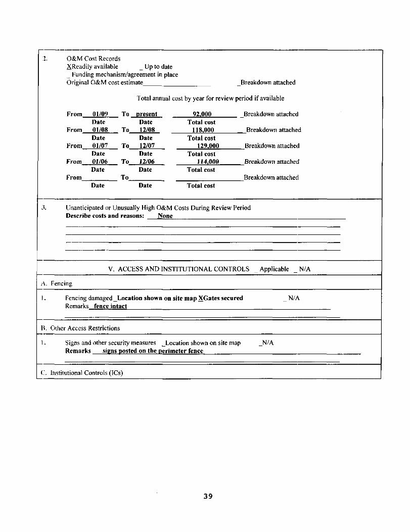
:!. O&M Cost Records XReadilyavailable _ Up to date _ Funding mechanism/agreement in place Original O&M cost estimate - Breakdown attached
Total annual cost by year for review period if available
From 01/09 To [lresent 921000 _Breakdown attached Date Date Total cost
From 01/08 To 12/08 1181000 Breakdown attached Date Date Total cost
From 01/07 To 12/07 1291000 Breakdown attached Date Date Total cost
From 01106 To 12/06 1141000 Breakdown attached Date Date Total cost
FJ"Om To Breakdown attached Date Date Total cost
J. Unanticipated or Unusually High O&M Costs During Review Period Describe costs and reasons: None
V. ACCESS AND INSTITUTIONAL CONTROLS _ Applicable N/A-
A Ft:ncing
Fencing damaged_Location shown on site map XGates secured N/A-1.
Remarks fence intact
B.Other Access Restrictions
Signs and other security measures _Location shown on site map - N/A1. Remarks sil:;ns [los ted on the [lerimeter fence
C. Institutional Controls (ICs)
39
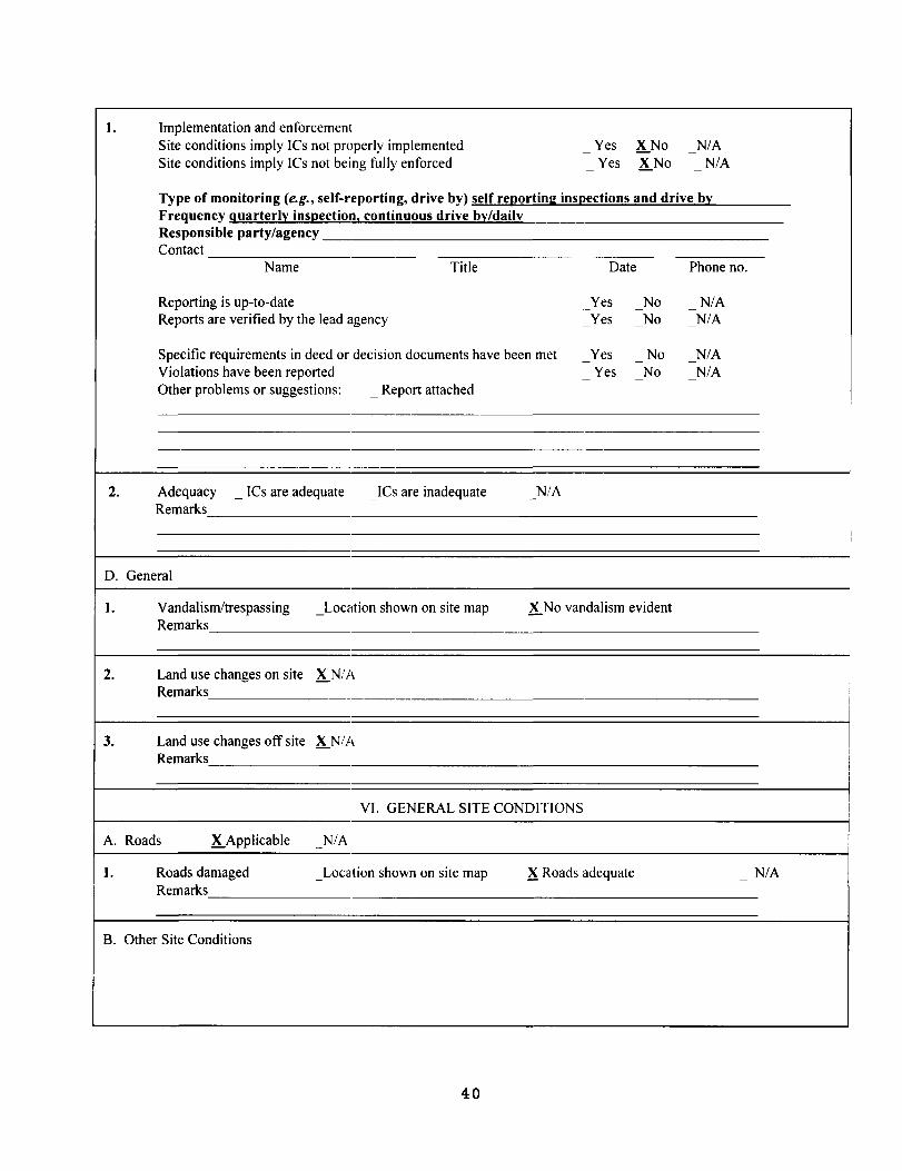
- -
1. Implementation and enforcemem Site conditions imply ICs not properly implemented Yes K.No N/A Site conditions imply ICs not being fully enforced
--
Yes K.No N/A
Type of monitoring (e.g., self-reporting, drive by) self reporting inspections and drive by Frequency guarterly inspection l continuous drive by/daily Responsible party/agency Contact
Name Title Date Phone no.
Reporting is up-to-date Yes No N/A Reports are verified by the lead agency
-Yes No
-N/A-
Specific requirements in deed or decision documents have been met Yes No N/A Violations have been reported
-Yes
-No N/A
Other problems or suggestions: _ Report attached -
2. Adequacy _ ICs are adequate _ICs are inadequate N/A Remarks
D. General
1. Vandal ism/trespass ing _Location shown on site map K.No vandalism evident Remarks
,
2. Land use changes on site K.N!A i
Remarks I
i
3. Land use changes off site XN/A I Remarks i
I i
VI. GENERAL SITE CONDITIONS
A. Roads K.Applicable N/A-
1. Roads damaged _ Location shown on site map X Roads adequate N/A Remarks
8. Other Site Conditions
40
I
f-I
-Remarks Overall, the site is in good condition.
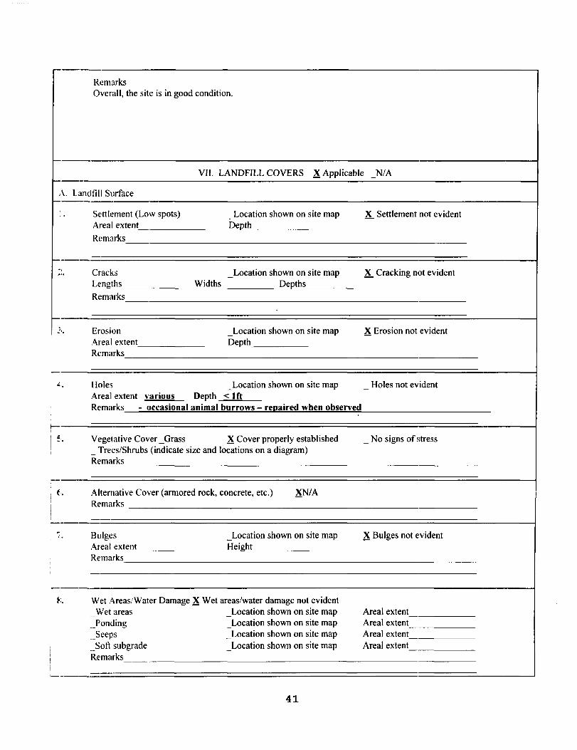
VII. LANDFILL COVERS ~ Applicable NIA
\. Landfill Surface --- .. Settlement (Low spots) _Location shown on site map X. Settlement not evident
Areal extent Depth-
Remarks
" Cracks _Location shown on site map X. Cracking not evident Lengths Widths Depths
Remarks
Erosion _Location shown on site map ~ Erosion not evident Areal extent Depth Remarks
Holes _Location shown on site map - Holes not evident Areal extent various Depth <1ft Remarks - occasional animal burrows - rel!aired when observed
Vegetative Cover _Grass ~ Cover properly established _ No signs of stress _ Trees/Shrubs (indicate size and locations on a diagram) Remarks
-t Alternative Cover (armored rock, concrete, etc.) ~/A
Remarks
-Bulges _Location shown on site map ~ Bulges not ~~vident Areal extent Height Remarks
-'. Wet Areas/Water Damage ~ Wet areas/water damage not evident
Wet areas _Location shown on site map Areal extent -]onding _Location shown on site map Areal extent __Seeps _Location shown on site map Areal extent __Soft subgrade _Location shown on site map Areal extent Remarks
-
41
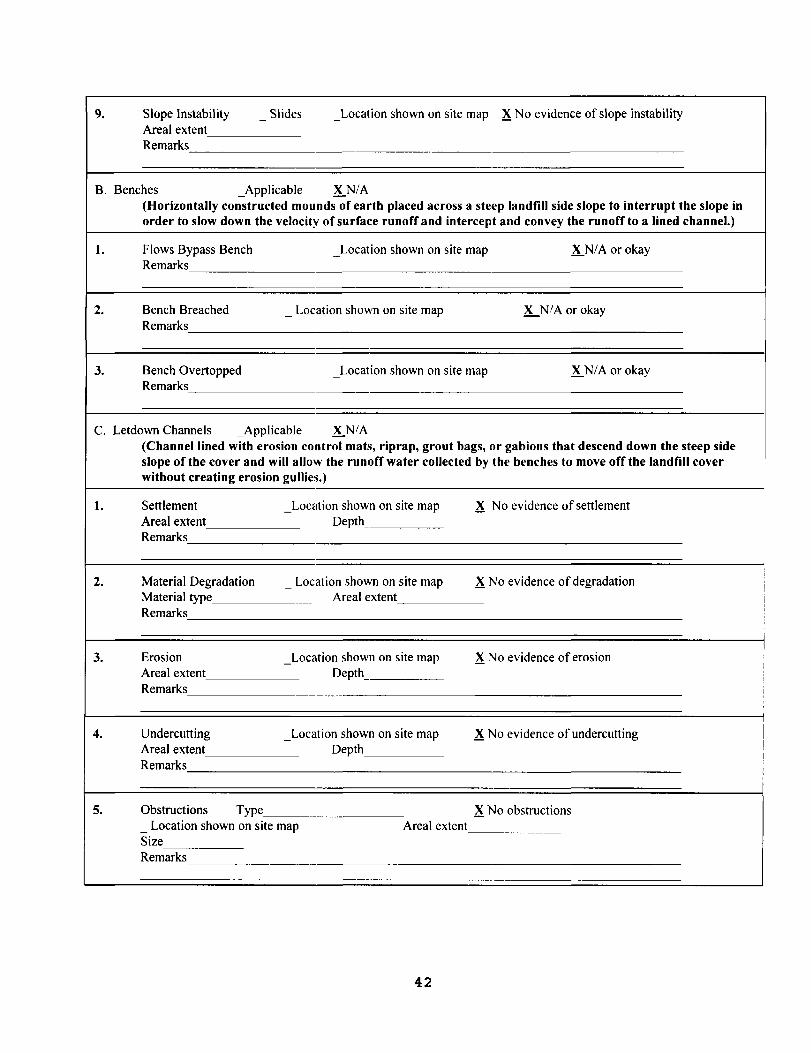
9. Slope Instability Slides _Location shown on site map ~ No evidence of slope instability Areal extent
-
Remarks
B. Benches _Applicable K.N/A (Horizontally constructed mounds of earth placed across a steep landfill side slope to interrupt the slope in order to slow down the velocity of surface runoff and intercept and convey the runoff to a lined channel.)
l. Flows Bypass Bench _Location shown on site map K.NIA or okay Remarks
2. Bench Breached _ Location shown on site map K...N/A or okay Remarks
3. Bench Overtopped _Location shown on site map K.N/A or okay Remarks
C. Letdown Channels _Applicable K.N/A (Channel lined with erosion control mats, riprap, grout bags, or gabions that descend down the steep side slope of the cover and will allow the runoff water collected by the benches to move off the landfill cover without creating erosion gullies.)
l. Settlement Areal extent
_Location shown on site map Depth
~ No evidence of settlement
Remarks
!
2. Material Degradation Material type
_ Location shown on site map Areal extent
~ No evidence of degradation !
i Remarks !
I
I 3. Erosion
Areal extent _Location shown on site map
Depth ~ No evidence of erosion I
i i
Remarks I
4. Undercutting Areal extent
_Location shown on site map Depth
~ No evidence of undercutting
Remarks
5. Obstructions Type ~ No obstructions _ Location shown on site map Areal extent Size Remarks
42
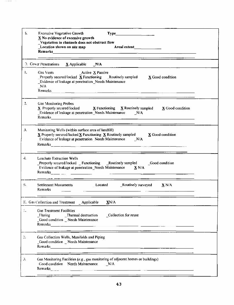
'J, Excessive Vegetative Growth Type X No evidence of excessive growth _Vegetation in channels does not obstruct flow _Location shown on site map Areal extent Remarks
-). Cov,~r Penetrations X Applicable N/A--I. Gas Vents - Active X Passive
_Properly secured/locked X Functioning _Routinely sampled X Good condition _Evidence of leakage at penetration_Needs Maintenance
N/A-Remarks
-~. Gas Monitoring Probes
X Properly secured/locked XFunctioning XRoutinely sampled X Good condition _Evidence of leakage at penetration_Needs Maintenance N/A Remarks
-I. Monitoring WeIls (within surface area oflandfill)
XProperly secured/locked XFunctioning XRoutinely sampled XGood condition _Evidence of leakage at penetration_ Needs Maintenance - N/A Remarks
I. Leachate Extraction WeIls _Properly secured/locked _ Functioning _Routinely sampled Good condition -_Evidence of leakage at penetration _Needs Maintenance XN/A Remarks
'. Settlement Monuments Located _Routinely surveyed XN/A-Remarks
" Gas CoIlection and Treatment _ Applicable XN/A
Gas Treatment Facilities Jlaring Thennal destruction - CoIlection for reuse -
Good condition Needs Maintenance - -Remarks
-, Gas CoIlection Wells, Manifolds and Piping
Good condition Needs Maintenance - -
Remarks
-I. Gas Monitoring Facilities (e.g., gas monitoring of adjacent homes or buildings)
Good condition Needs Maintenance N/A. -
Remarks
-
43

-------
F. Cover Drainage Layer X Applicable N/A-
1. Outlet Pipes Inspected _Functioning LN/A Remarks outlet is a stone toe (i.e. no dal:lil:;ht I!il!es}
2. Outlet Rock Inspected X Functioning _NlA Remarks
G. Detention/Sedimentation Ponds X Applicable N/A-
1. Siltation Areal extent Depth N/A X Siltation not evident
-
Remarks
2. Erosion Areal extent Depth X Erosion not evident Remarks
3. Outlet Works X Functioning N/A-Remarks
4. Dam _Functioning XN/A Remarks
H. Retaining Walls X Applicable N/A-
1. Deformations _Location shown on site map X Deformation not evident Horizontal displacement Vertical displacement Rotational displacement Remarks
2. Degradation _Locution shown on site map X Degradation not evident Remarks
,
I. Perimeter Ditches/Off-Site Discharge X Applicable N/A-l. Siltation _Location shown on site map X Siltation not evident
Areal extent Depth_ Remarks
2. Vegetative Growth _ Location shown on site map XN/A _ Vegetation does not impede flow Areal extent Type Remarks
I
44
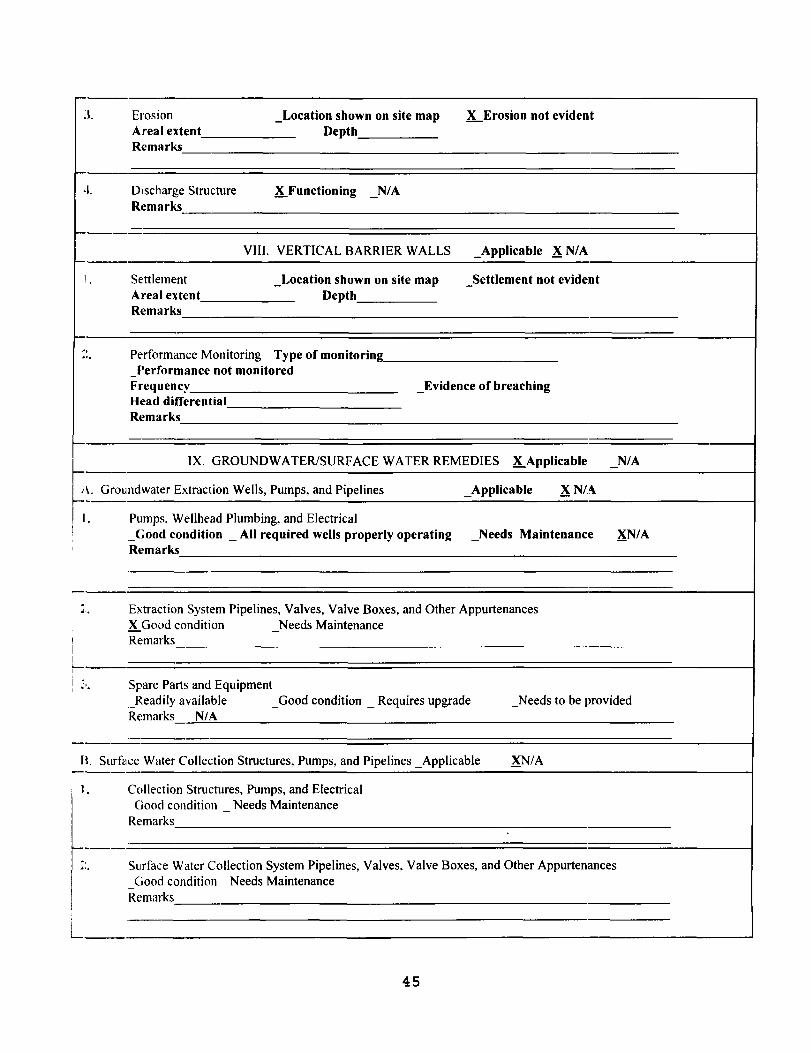
--
;--
J. Erosion _Location shown on site map K...Erosion not evident Areal extent Depth Remarks
.1. Discharge Structure X Functioning N/A-Remarks
-
_._- VIII. VERTICAL BARRIER WALLS _Applicable XN/A
1 Settlement Areal extent Remarks
_Location shown on site map Depth
Settlement not evident-
_. -, Perfonnance Monitoring Type of monitoring'"
Performance not monitored -Frequency _Evidence of breaching Head differential Remarks
-. IX. GROUNDWATER/SURF ACE WATER REMEDIES X Applicable N/A_. -
Groundwater Extraction Wells, Pumps, and Pipelines _Applicable XN/A~~. I I. Pumps, Wellhead Plumbing, and Electrical ! _Good condition _ All required wells properly operating Needs Maintenance XN/A-, Remarks
Extraction System Pipelines, Valves, Valve Boxes, and Other Appurtenances '" X.Good condition Needs Maintenance
I Remarks i I '--I
i ,
~," Spare Parts and Equipment
_Readily available - Good condition _ Requires upgrade _Needs to be provided Remarks N/A
--B. Surface Water Collection Structures, Pumps, and Pipelines _Applicable XN/A
I. Collection Structures, Pumps, and Electrical
.-Good condition - Needs Maintenance Rf:marks
r---- -,.... Surface Water Collection System Pipelines, Valves, Valve Boxes, and Other Appurtenances
Good condition Needs Maintenance .
R{:marks
45
L
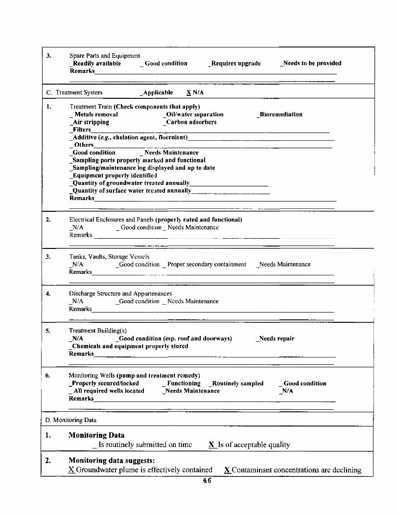
- -
- -
3. Spare Parts and Equipment _Readily available Good condition _Requires upgrade _Needs to be provided -Remarks
C. Treatment System _App,licable XN/A
l. Treatment Train (Check compol1ents that apply) Metals removal _Oil/water separation Bioremediation
_Air stripping Carbon adsorbers-Filters -
_Additive (e.g., chelation agent, flocculent) Others -Good condition Nef'ds Maintenance
_Sampling ports properly marked and functional _Sampling/maintenance log displayed and up to date _Equipment properly identified _Quantity of groundwater treated annually _Quantity ofsurface water treated annually Remarks
2. Electrical Enclosures and Panels (properly rated and functional) N/A Good condition Needs Maintenance -
Remarks
3. Tanks, Vaults, Storage Vessels N/A _Good condition _ Proper secondary containment Needs Maintenance
Remarks
4. Discharge Structure and Appurtenances N/A Good condition Needs Maintenance
Remarks -
5. Treatment Building(s) N/A _Good condition (esp. roof and doorways) _Needs repair-
_Chemicals and equipment properly stored Remarks
6. Monitoring Wells (pump and treatment remedy) _Properly secured/locked _ Functioning _Routinely sampled - Good condition _ All required wells located Needs Maintenance- N/A Remarks
D. Monitoring Data
1. Monitoring Data _ Is routinely submitted on time X...Is of acceptable quality
2. Monitoring data suggests: X Groundwater plume is etJectively contained X Contaminant concentrations are declining
46
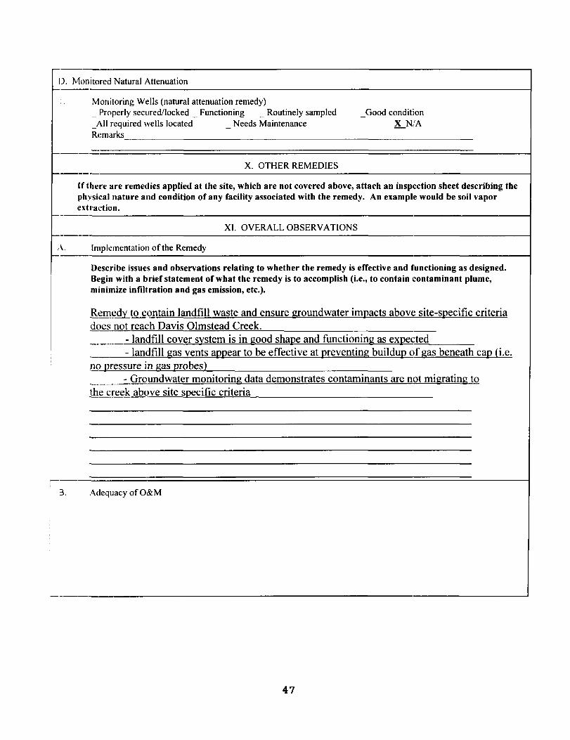
I). Mon itored Natural Attenuation
Monitoring Wells (natural attenuation remedy) _ Properly secured/locked _ Functioning _ Routinely sampled - Good condition _All required wells located Needs Maintenance - K...N,'A Remarks
X. OTHER REMEDIES
(f 1here are remedies applied at the site, which are not covered above, attach an inspection sheet describing the physical nature and condition of any facility associated with the remedy. An example would be soil vapor ·ext raction.
XI. OVERALL OBSERVATIONS
A. Implementation of the Remedy
Describe issues and observations relating to whether the remedy is effective and functioning as designed. Begin with a brief statement of what the remedy is to accomplish (i.e., to contain contaminant plume, minimize infiltration and gas emission, etc.).
Remedy to contain landfill waste and ensure groundwater imQacts above site-sQecific criteria does not reach Davis Olmstead Creek.
- landfill cover system is in good shaQe and functioning as eXQected - landfill gas vents aQQear to be effective at Qreventing builduQ of gas beneath caQ (i.e.
no Qressure in gas Qrobes} - Groundwater monitoring data demonstrates contaminants are not migrating to
the creek above site sQecific criteria
3. Adequacy of O&M
47
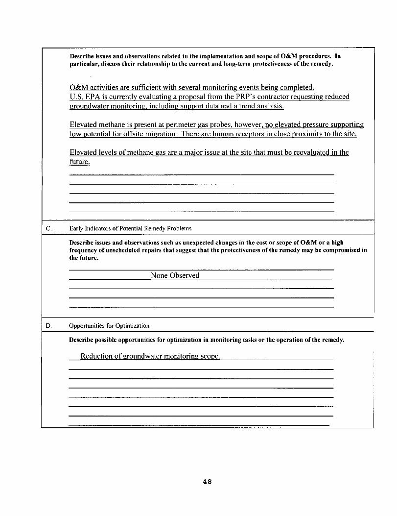
Describe issues and observations related to the implementation and scope of O&M procedures. In particular, discuss their relationship to the current and long-term protectiveness of the remedy.
O&M activities are sufficient with several monitoring events being com12leted. U.S. EPA is currently evaluating a 12ro12osal from the PRP's contractor reguesting reduced groundwater monitoring, including sU12120rt data and a trend analysis.
Elevated methane is 12resent at 12erimeter gas Qrobes, however, no elevated 12ressure sU12120rting low 120tential for offsite migration. There are human rece12tors in close Qroximity to the site.
Elevated levels of methane gas are a major issue at the site that must be reevaluated in the future.
C. Early Indicators of Potential Remedy Problems
Describe issues and observations such as unexpected changes in the cost or scope of O&M or a high frequency of unscheduled repairs that suggest that the protectiveness of the remedy may be compromised in the future.
None Observed
D. Opportunities for Optimization
Describe possible opportunities for optimization in monitoring tasks or the operation of the remedy.
Reduction of groundwater monitoring scoQe.
48

ATTACHMENT 5 - INTERVIEW SURVEY FORMS
49

50
I
I\ame
lelephone No:
Fax rio:
E·-[1a:.l 1I.ddress:
[ate Submitted:
-=.=====,===~-=----~----I-----~~-===~==-------"""
1. What is your overall impression of the cleaned-up portions of this Superfund Site? (9:~nel'al sentiment)
The sjte looks great. The contoured, vegetated surface is an improvement to the former un=ap~,ed landfill. The mitigation wetlands handle a majority of the surface runoff, are attractive, and provide wildlife habitat.
2. Are you aware of any community concerns regarding the site administration related to conplEted clean-up activities? If so, please give details.
;.m !l.ot aware of any communi ty concerns.
3. ~re you aware of any events, incidents, or activities at the site such as vandalism, t~~spassing, or emergency responses from local authorities? If so, please give dates, de:ails, and outcome(s) if known.
No.
-1. Do you have any comments, suggestions, or recommendations regarding the site's man3gement or operation?
No.
(Form continued on next page)
===,=======,=====----=====------======--====================~
51
Services Landfill Superfund Site Five·-Year Review Comment and Information Survey
M.ichi.gan Disposal
Organization: City of Kalamazoo
269-337-8365
269-337-8535
rutlandc@gmail. com
11/30/09
Street Address: 1415 North Harrison
City: Kalamazoo
State, Zip: MI 49008
Michigan Disposal Services Landfill Superfund Site Five-Year Review Comment and Information Survey
Organization: City of KalamazooName: Carolyn Rutland
Telephone No: 269-337-8365 Street Address: 1415 North Harrison
City: KalamazooFax No: 269-337-8535
E-Mail Address: rutlandc@gmailocom State, Zip: MI 49008
Date Submitted: 11/30/09
50 Are you aware of any issues that may require changes to the completed remedial actions or the decision documents?
No.
60 Have any problems or difficulties been encountered regarding institutional controls or deed restrictions?
No.
70 Do you feel the completed rerrledies are functioning as expected? Why or why not?
Yes. The cap and cap-related elements regularly pass quarterly operation and maintenance inspections. The leachate collection system discharges to the City of Kalamazoo sanitary sewer without problems under the City's NPDES discharge permit. The fence is effective in restricting access to the site. The groundwater monitoring continues to demonstrate that the groundwater-surface water-mixing zone is clean of contaminants and no further action is necessary.
80Are you aware of any issues, which may call into question the site's short-term or longterm protectiveness?
No.
90Are you aware if there are any trends that indicate contaminant levels are increasing or decreasing?
The contaminant levels appear to be decreasing or constant.
(Form continued on next page)
52

Michigan Disposal Services Landfill Superfund Site Five-Year Review Comment and Information Survey
~·ame : Carolyn Rutland Organization: City of Kalamazoo
~.~---~------~--~~~~=-~~~------------~~--------~--------~~----~--~--~-----------4Telephone No: 269-337-8365 Street Address: 1415 North Harrison
Fax No: 269-337-8535 City: Kalamazoo
E--Mail A.ddress: [email protected] State, Zip: MI 49008
i =====.-=.-=-.-------=-=============--------------~---=-===-================-==----------============~ ,
10. Is there a continuous O&M presence? Please describe staff and frequency of site inspections and activities.
There is not a continuous O&M presence. The site is inspected quarterly, at a minimum. Groundwater and surface water are sampled quarterly. Other activities (e.g., mowing) take place as necessary.
11. Have there been any significant changes in O&M requirements, maintenance schedules, or f;ampling routines? If so, do they affect the protectiveness or effectiveness of the remedy?
No.
12. Ha.ve there been unexpected O&M difficulties or costs at the site? If so, please give detai:"s.
No.
13. Do you have any other comments, concerns or recommendations regarding the project?
No.
(Form continued on next page)
.=====.-=============-=======----==-----========-------============--======.==============================----~
53

Michigan Disposal Services Landfill Superfund Site Five-Year Review Comment and Information Survey
Organization: Michigan Dept. of Environmental Management Superfund (MDEQ)
Telephone No: 517-373-9832
Name: Mary B. Schafer
Street Address: 525 West Allegan Fax No: 517-335-4887 City: Lansing E-Mail Address: State: Michigan [email protected] Zip: 48909 Date Submitted: 11/30/09
1. What is your overall impression of the cleaned-up portions of this Superfund Site? (general sentiment)
Overall. This landfill is inspected and issues addressed.
2. Are you aware of any community concerns regarding the site administration related to completed clean-up activities? If so, please give details.
I am not aware of any community concerns regarding the site administration of the landfill.
3. Are you aware of any events, incidents, or activities at the site such as vandalism, trespassing, or emergency responses from local authorities? If so, please give dates, details, and outcome(s) if known.
It has been reported that on at least one occasion, a vehicular accident on the adjacent highway resulted in damage to the perimeter fence.
4. Do you have any comments, suggestions, or recommendations regarding the site's management or operation?
The city of Kalamazoo does a good job of monitoring this site. A recent mistake in data collection has been noted by the City and is being corrected. (Two monitoring wells were mistakenly left off an updated list and have not been sampled for a while.)
(Form continued on next page)
54
Michigan Disposal Services Landfill Superfund Site Five-Year Review Comment and Information Survey
Nane: Mary B. Schafer
Te:.ephone No: 517-373-9832 Feu: No: 517-335-4887 B-Uail Address: S~h,afe'~I~Pm~.~~~ Date Sul:.mitted: 11/30/09
organization: Michigan Dept. of Bnvironmental Management Superfund (MDEQ)
Street Address: 525 West Allegan City: Lansing State: Michigan Zip: 48909
,~=_===,=_~~_____.t...-~======______~=========~__p
l'I'hat i~: your overall impression of the cleaned-up portions of this Superfund Site? 'ger~ral sentiment)
)verall. This landfill is inspected and issues addressed.
_. Are you aware of any community concerns regarding the site administration related to =om~leted clean-up activities? If so, please give details.
[ arc, not aware of any communi ty concerns regarding the si te administration of the I.anci.fill.
l. Fre you aware of any events, incidents, or activities at the sit:e such as vandalism, trespassing, or emergency responses from local authorities? If so, please give dates, details, and outcome(s) if known.
It has been reported that on at least one occasion, a vehicular accident on the adjacent :lighway resul ted in damage to the perimeter fence.
·k, Do y::m have any comments, suggestions, or recommendations regarding the site' s llanagement or operation?
'~he city of Kalamazoo does a good job of monitoring this site. A recent mistake in data t:ollect:ion has been noted by the City and is being corrected. (Two monitoring wells Here mistakenly left off an updated list and have not been sampled for a while.)
(Form continued on next page)
55
Michigan Disposal Services Landfill Superfund Site Five-Year Review Comment and Information Survey
Name: Mary B. Schafer
Telephone No: 517-373-9832 Fax No: 517-335-4887 E-Mail Address: [email protected] Date Submitted: 11/30/09
Organization: Michigan Dept. of Environmental Management Superfund (MDEQ) Street Address: 525 West Allegan City: Lansing State: Michigan Zip: 48909
5. Are you aware of any issues that may require changes to the completed remedial actions or the decision documents?
No.
6. Have any problems or difficulties been encountered regarding institutional controls or deed restrictions?
The institutional controls need to be updated. That is being addressed.
7. Do you feel the comple"ted remedies are functioning as expected? Why or why not?
The landfill does have a seepage area. It is likely a result of the subsurface drain construction rather than a problem, but it should be watched.
8. Are you aware of any issues, which may call into question the site's short-term or long-term protectiveness?
Methane gas continues to be an issue at this site. The levels have exceeded criteria at times in several locati,:)ns. In the recent past. This situation deems follow up evaluation.
9. Are you aware if there are any trends that indicate contaminant levels are increasing or decreasing?
am not aware of any significant trends on the site. The unionized ammonia does spike periodically and may need to be evaluated further.
(Form continued on next page)
56
I
ATTACHMENT 6 - LIST OF DOCUMENTS REVIEWED
57
LIST OF DOCUMENTS REVIEWED FOR
SECOND FIVE-YEAR REVIEW
• Remedial Investigation/Feasibility Study, June 4, 1987
• Record of Decision, September 30,1991
• Administrative Order on Consent, August 27, 1996
• Restrictive Covenants, Kalamazoo County Filing Date - July 10, 1997
• Unilateral Administrative Order, May 14, 1998
• Remedial Design, June 12, 1998
• Remedial Action, December 1, 1999
• Record of Decision (ROD) Amendment, September 25,2002
• Preliminary Close Out Report based on ROD Amendment, September 25, 2002
• First Five-Year Review, December 10, 2004
• Operation and Maintenance (O&M) Plan, October 13,2004
• O&M Report (June 2009 Sampling), received on September 18, 2009
• Revised Groundwater / Surface Water Interface (GSI) Monitoring Plan, received on September 18, 2009
• O&M Report (September 2009 Sampling), received on November 16, 2009
58

ATTACHMENT 7- SITE INSPECTION PHOTOS
59
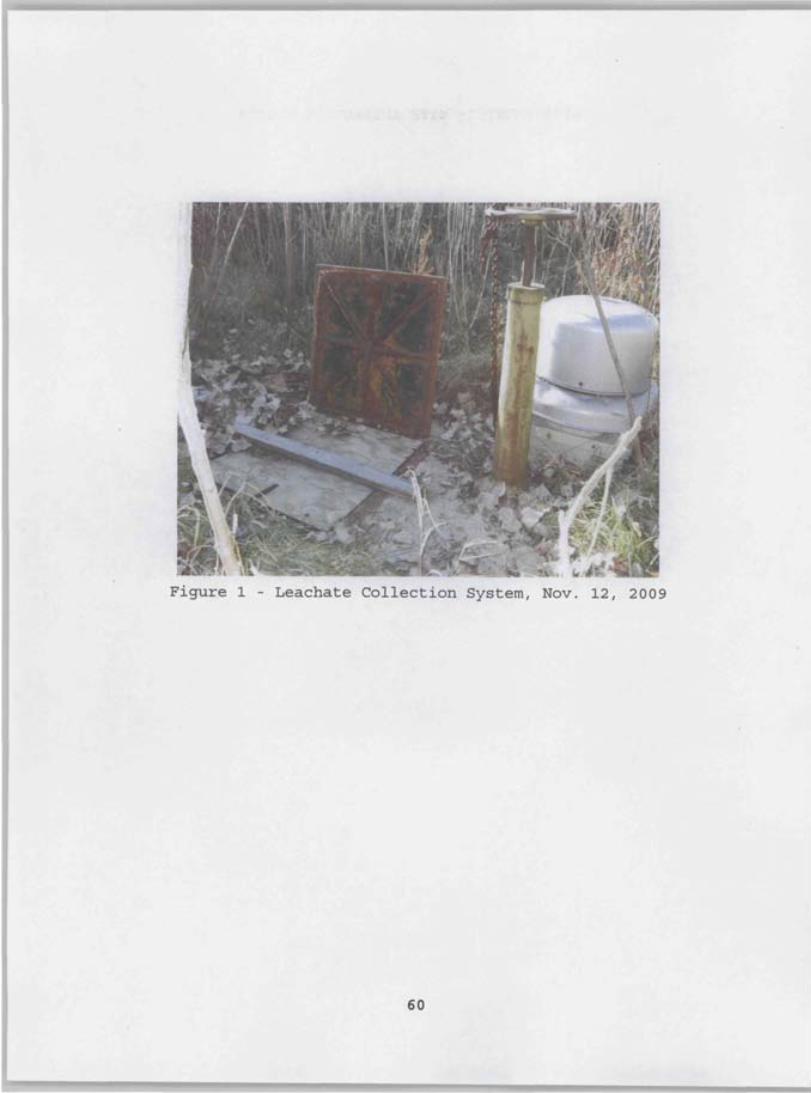
Figure 1 - Leachate Collection System, Nov. 12, 2009
60
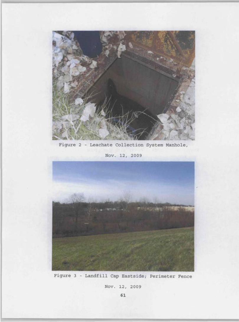
Figure 2 - Leachate Collection System Manhole,
Nov. 12, 2009
Figure 3 - Landfill Cap Eastside; Perimeter Fence
Nov. 12, 2009
61
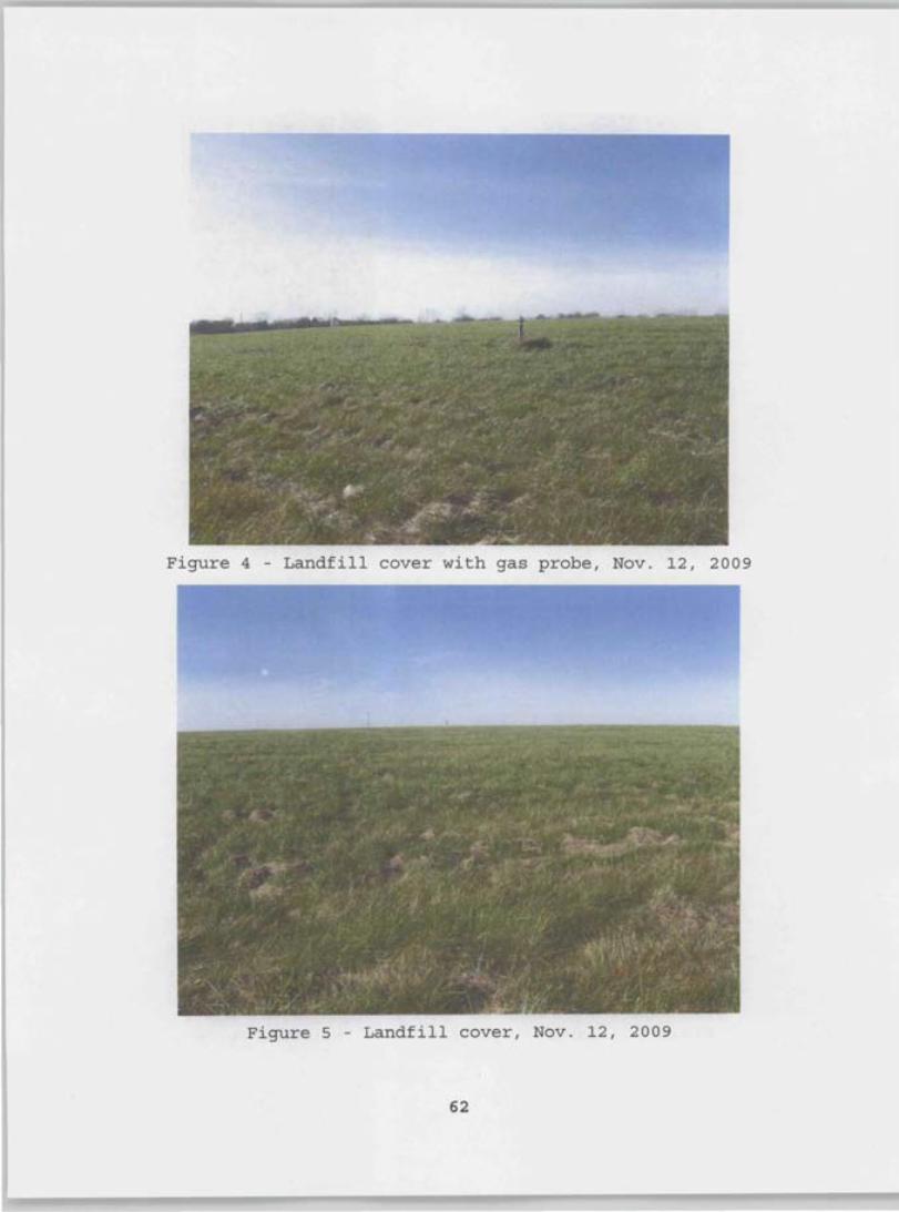
Figure 4 - Landfill cover with gas probe, Nov. 12, 2009
Figure 5 - Landfill cover, Nov. 12, 2009
62
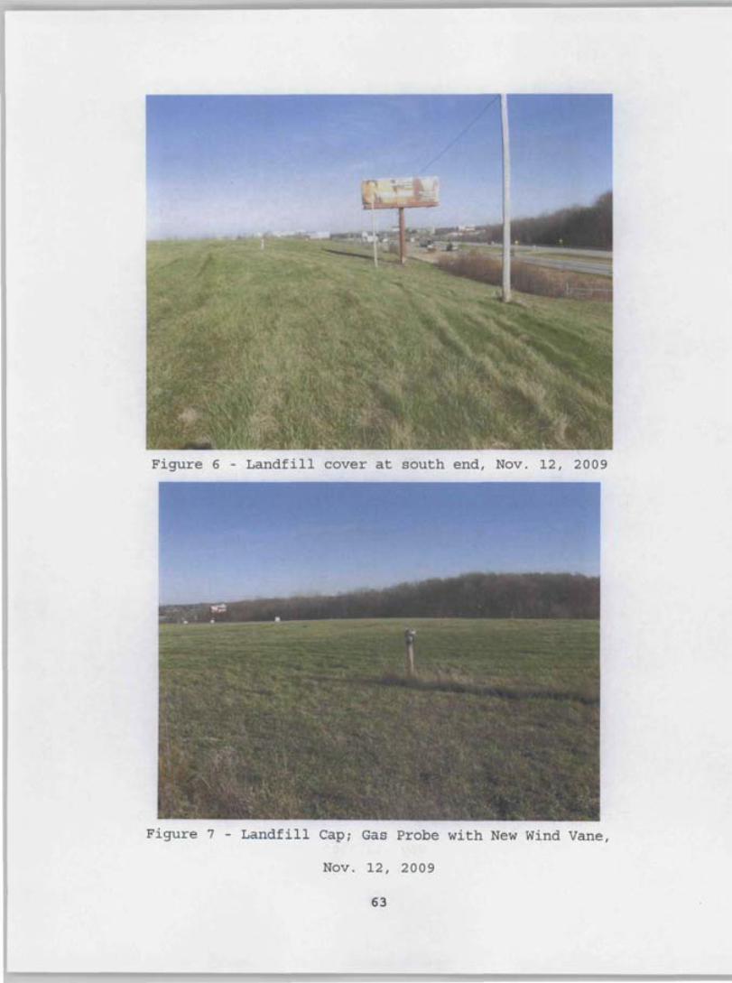
, .. -
'i;.'-':, ; ~ .', ",,' * "::_"'" 1 _, •• '.,: ~ , .' ::. ,,' ,:. '-! .,.~/ , ~,' ,-'~'
Figure 6 - Landfill cover at south end, Nov. 12, 2009
.
'-
I
, . " ,
r'. : "" .~... _~ ;. ~. ~
Figure 7 - Landfill Cap; Gas Probe with New Wind Vane,
Nov. 12, 2009
63
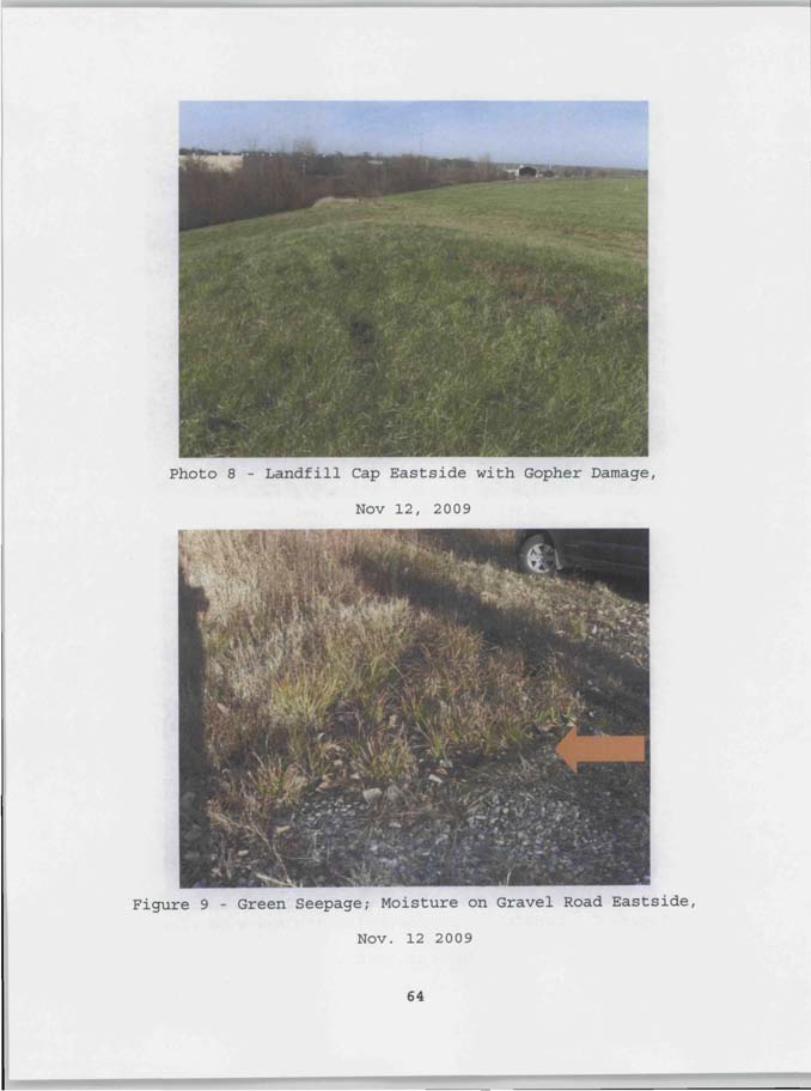
Photo 8 - Landfill Cap Eastside with Gopher Damage,
Nov 12, 2009
Figure 9 - Green Seepage; Moisture on Gravel Road Eastside,
Nov. 12 2009
64
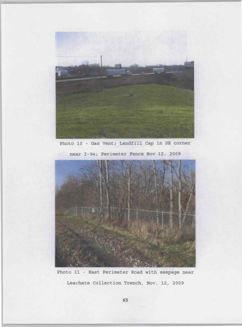
Photo 10 - Gas Vent; Landfill Cap in SE corner
near 1-94; Perimeter Fence Nov 12, 2009
Photo 11 - East Perimeter Road with seepage near
Leachate Collection Trench, Nov. 12, 2009
65

Photo 12 - East Perimeter Fence and Manhole that
drains to Davis Creek, Nov. 12, 2009
Photo 13 - East Perimeter Fence & Drainage Ditch
with overgrown grass, Nov. 12, 2009
66
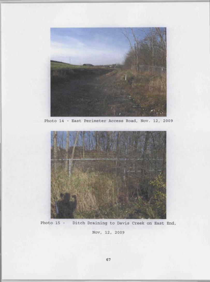
Photo 14 - East Perimeter Access Road, Nov. 12, 2009
Photo 15 - Ditch Draining to Davis Creek on East End,
Nov, 12, 2009
67
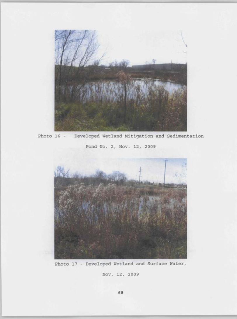
Photo 16 - Developed Wetland Mitigation and Sedimentation
Pond No.2, Nov. 12, 2009
Photo 17 - Developed Wetland and Surface Water,
Nov. 12, 2009
68
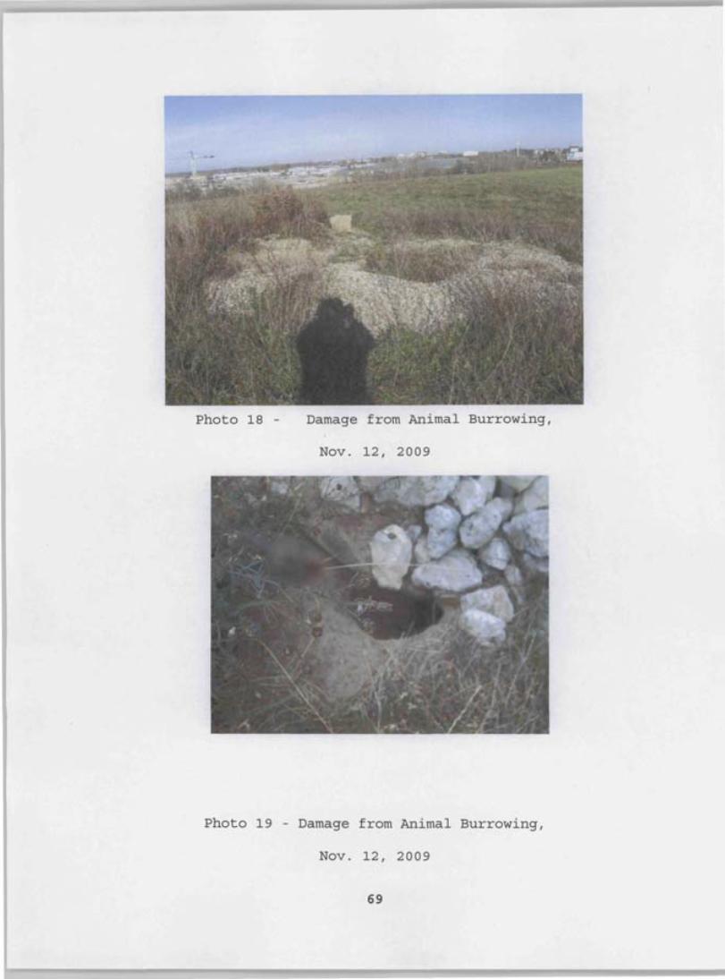
Photo 18 - Damage from Animal Burrowing,
Nov. 12, 2009
Photo 19 - Damage from Animal Burrowing,
Nov. 12, 2009
69