scoping document 2 blue lake … lake hydroelectric project expansion . ferc no. 2230 . ......
TRANSCRIPT

SCOPING DOCUMENT 2
BLUE LAKE HYDROELECTRIC PROJECT EXPANSION
FERC No. 2230
Prepared By:
City and Borough of Sitka Electric Department
105 Jarvis Street Sitka, AK, 98358
June, 2009

TABLE OF CONTENTS
LIST OF TABLES ........................................................................................ iii LIST OF FIGURES ...................................................................................... iii INTRODUCTION...........................................................................................1 NEED for ACTION ........................................................................................2 APPLICANT INFORMATION ....................................................................2 PROJECT LICENSING STATUS................................................................4 ISSUANCE OF NEW LICENSE...................................................................4 ALTERNATIVE LICENSING PROCESS ..................................................4 LICENSE AMENDMENT and CONSTRUCTION SCHEDULE.....................................................................................................4 THE SCOPING PROCESS ...........................................................................5 PURPOSE OF SCOPING ..............................................................................5 SCOPING STEPS ...........................................................................................5 DATE and TIME OF MEETINGS ...............................................................6 PROCEDURES for SUBMITTING COMMENT .......................................6 REQUEST FOR INFORMATION ...............................................................7 PROPOSED ACTION and ALTERNATIVES............................................7 DESCRIPTION of the EXISTING PROJECT............................................8 PROJECT LANDS…………………………………………………………14 FEATURES EXPECTED TO CHANGE ...................................................15 NEW POWERHOUSE and TURBINES ....................................................15
i

Water Delivery to New Powerhouse............................................................15 Surge Tank ....................................................................................................15 Switchyard.....................................................................................................15 PROPOSED DAM RAISING ......................................................................18 PROJECT OPERATION.............................................................................21 ALTERNATIVE(S) EVALUATED BUT ELIMINATED FROM FURTHER CONSIDERATION .........................21
ENVIRONMENTAL RESOURCES, ISSUES and RECOMMENDATIONS .......................................................23
AFFECTED ENVIRONMENT ...................................................................23 Description of the Locale..............................................................................23 Geology and Soils ..........................................................................................24 Water Resources ...........................................................................................25 Blue Lake and Sawmill Creek Water Rights .............................................30 Fish and Aquatic Resources.........................................................................31 Wildlife and Botanical Resources................................................................35 Wetlands, Riparian, And Littoral Habitat .................................................36 Recreation And Land Use ............................................................................36 Land Use Within/Adjacent to Project Boundary.......................................39 Cultural Resources .......................................................................................39 Socio-Economic Resources...........................................................................39 Scenic and Aesthetic Resources ...................................................................41 Threatened and Endangered Species ..........................................................41 Subsistence Resources ..................................................................................42 ENVIRONMENTAL ISSUES AND STUDIES..........................................43 Fisheries and Aquatic Resources Issues......................................................43
Wildlife...............................................................................................45 Botanical Resources ..........................................................................46
Water Quantity .............................................................................................47 Water Quality................................................................................................47 Geology and Soils ..........................................................................................48 Cultural Resources .......................................................................................48 Scenic and Aesthetic Resources ...................................................................49 Socioeconomics..............................................................................................49 Threatened and Endangered Species. .........................................................50 Subsistence Resources ..................................................................................50
ii

APPLICABLE COMPREHENSIVE PLANS............................................51 REFERENCES..............................................................................................52 PARTICIPANT LIST...................................................................................54
LIST OF TABLES
Table 1. Land Descriptions of Blue Lake Project Features .....................14 Table 2. Potential Energy and Inundated Area for Dam Height of El 425 ............................................................................21 Table 3. Representative Concentrations Of Various Blue Lake Organic And Inorganic Contaminants .......................................................25 Table 4. Maximum and Minimum Average Daily Flows in Sawmill Creek ................................................................................27 Table 5 . Current water rights relating to Blue Lake Project .................30 Table 6. Sawmill Creek Reach Numbering ...............................................32 Table 7. Estimated Total Subsistence Harvests of Wild Resources ........43
LIST OF FIGURES
Figure 1. City of Sitka Electrical Load Forecast..........................................3 Figure 2. Blue Lake Project Area Map........................................................9 Figure 3. Blue Lake Project Features ........................................................10 Figure 4. Blue Lake Project Power Conduit Schematic...........................11
Figure 5. Blue Lake Generating Unit.........................................................13 Figure 6. Expansion New Powerhouse Site Plan.......................................16 Figure 7. Proposed Surge Chamber Profile ..............................................17 Figure 8. Elevation View of Dam Area ......................................................19 Figure 9. Plan View of Dam Intake Area....................................................20
iii

iv
Figure 10. Plan View of Blue Lake Inundation.........................................22 Figure 11. Composite Blue Lake Water Temperatures ...........................26 Figure 12. Sawmill Creek Pre-Project Flow Duration Curve .................28 Figure 13. Sawmill Creek Pre-Project Monthly Flows ............................29 Figure 14. Sawmill Mill Creek Temperatures...........................................29 Figure 15. Blue Lake Project Land Use Map.............................................40

SCOPING DOCUMENT 2
BLUE LAKE HYDROELECTRIC PROJECT EXPANSION
FERC No. 2230
City and Borough of Sitka Electric Department
Sitka, AK
June, 2009
INTRODUCTION
Recent energy needs analyses conducted by the City and Borough of Sitka Electric Department (“City”) have shown that, in order to assure continued delivery of low cost electrical power in the face of rising energy needs in Sitka, it must expand its electrical generating base. Among other alternatives, the City is examining expansion of their Blue Lake hydroelectric project [“Project”, Federal Energy Regulatory Commission (FERC) No. 2230] near Sitka, Alaska. The primary actions of the Project expansion would be: 1) installing a new powerhouse and two new, larger, generating turbines near the existing Project powerhouse (the existing turbines would be removed); and 2) raising the height of the Project dam. Together, these actions would result in more efficient use of Blue Lake and Sawmill Creek water resources and a significant gain in electrical generation potential. The powerhouse/turbine replacement component is referred to in this document as the “New Powerhouse” and raising the Project dam is referred to as the “Dam Raise”. Collectively, these actions and their related infrastructure and construction are referred to as the “Blue Lake Project Expansion”, or simply “Expansion”. Under FERC regulations, the Expansion would require a “Capacity-Related” amendment to the existing FERC license. FERC regulations require the City to complete an amendment application process involving environmental, engineering and economic studies and analyses. FERC regulations also require that the City consult with a list of Stakeholders, including state and federal resource agencies, affected tribal entities, non-governmental organizations (NGO’s), interest groups and the public. This SD1 is one of a series of documents required to in part fulfill FERC amendment application requirements.
1

NEED for ACTION
The City’s recent electrical load forecasts show a marked increase in electrical demand in the near future (Figure 1). Two primary factors have driven this increase: First, fuel costs in Sitka over the past four years have nearly tripled, making electric heating economically preferable to oil heating and driving up electrical demand in locations with a choice between oil-based and electrical heat. Second, recently-constructed high energy-need industries in Sitka have added to overall electrical demand. These load increases, if met only by the City’s existing electric generation capacity, would require an increase in expensive and polluting diesel generation within a few years unless hydroelectric generating capacity is increased. Key to the City’s planning is continued preference for hydroelectric generation to assure lower electrical rates over time and increased environmental acceptability when compared to use of diesel fuel, the only other current generation alternative. The City has explored various hydroelectric generation alternatives, including the Lake Diana hydro project (FERC No. 12716-001). The Lake Diana Project, owing to its location in an existing wilderness area, has proven unfeasible. Other hydroelectric proposals are under evaluation, but due to development schedules and costs they cannot be available in time to meet Sitka’s immediate needs. Engineering studies have shown that the Blue Lake Expansion, as proposed in this document, would generate energy equal to or exceeding that expected from the Lake Diana Project.
BACKGROUND AND DEVELOPMENT OF SD2 This document is a revision of Scoping Document 1 (SD1) issued in September, 2008. Written comments on SD1 were received from US Department of Agriculture Forest Service (USFS) and from Sitka Conservation Society (SCS). The City has responded to all Scoping comments through the modifications detailed in this document’s Consultation Section. New or modified text resulting from these changes has been italicized. We believe that there are no disputes on issues requiring resolution prior to preparation of the Draft Amendment Application. In addition to changes documented in the Consultation Section, other sections of SD1 were modified during development of SD2 to more accurately reflect the status of the relicensing process. New text in these sections is also italicized and underlined to highlight the additions. Note that these changes were not the result of agency comments, but were voluntary on the City’s part. Finally, we have deleted the material from SD1 and the Draft SD2 describing, in future tense, public and agency meeting and site visit and schedules and requests for comments on those documents. All meetings, the site visit and comments are described in past tense in this Final SD2 to avoid confusion.
2
CONSULTATION Copies of SD1 were distributed electronically on Nov. 11, 2008, with a cover letter describing the review process and dates and places of the Scoping Meeting and Site Visit. After the meeting and site visit held on December 11, 2009, comments were received from USFS and Sitka Conservation Society (SCS). Copies of the comment letters and assigned comment numbers are in Attachment I. All comments were address either through changes in the SD1 text (reflected in SD2 as italicized text) or by explanation in the Tables in Attachment II. The City believes that it has addressed all comments, and that we have made all proposed changes as requested. We have no disputes with the changes requested in the comment letters.
APPLICANT INFORMATION The exact name, business address and telephone number of the Licensee is:
City & Borough of Sitka 100 Lincoln Street Sitka, Alaska, 99835 Phone: 907-747-3294
The exact name, business address and contact numbers of the person authorized to act as agent for the Licensee is:
City & Borough of Sitka, Electric Department Attn: Christopher Brewton, Utility Director 105 Jarvis Street Sitka, Alaska 99835 Phone: 907-747-1870 Fax: 907-747-3208
3

Figure 1. City of Sitka Electrical Load Forecast
4

PROJECT LICENSING STATUS
ISSUANCE of NEW LICENSE The original 50-year Blue Lake Project license was issued by FERC in March of 1958 and expired in March of 2008. The FERC issued a new license for the Project effective March 31, 2008, following an extensive relicensing process. The new license reflected no change in general Project configuration or operation, but Articles to the license, based on extensive Stakeholder consultation during relicensing, required several actions by the City. Proposals for the new license did not include significant changes to the Blue Lake Project design or operation because at the time the relicensing process began and throughout most of the relicensing process, the fuel and load-related conditions described above did not exist. Only after the relicensing process was nearly complete did it become apparent that additional hydroelectric generation would be necessary. ALTERNATIVE LICENSING PROCESS Under an amendment of the Federal Power Act (FPA), licensees may elect to use the Traditional Licensing Approach or the Alternative Licensing Procedure (ALP). Under the Traditional Approach, all activities and documents required under the National Environmental Policy Act (NEPA) are conducted by the FERC or their contractor after acceptance of the Application for new license. This FERC action may take as long as two years to complete. Under the ALP, the licensee may conduct NEPA Scoping (the public participation process to solicit comments on environmental issues) and may prepare a Preliminary Draft Environmental Assessment (PDEA) (first in a series of EA’s) prior to submittal of the Application. The City applied to FERC for use of ALP by letter dated March 11, 2008, and FERC authorized use of the ALP by letter dated Sept 2, 2008, after gaining Stakeholder approval of process use and a required Communications Protocol. LICENSE AMENDMENT and CONSTRUCTION SCHEDULE The City intends to proceed as quickly as possible toward completion of the Expansion. Because of the extensive information base available through the recent Project relicensing, an accelerated schedule is possible. Generally, environmental studies for the draft license amendment will be completed in fall, 2009, with certain specific exceptions. This completion will allow distribution of the Draft Amendment Application (DAA) in summer, 2009. After the required 60-day review of the DAA, the City will continue to refine project design through more advanced engineering analyses during the second half of 2009 and early 2010. Also during this time period the City will conduct Stakeholder negotiations on terms and conditions which will become Articles to the
5

amended license. The Final Amendment Application (FAA) is scheduled to be submitted to the FERC in spring, 2010. After FERC review and acceptance of the FAA (generally completed in about 3-4 months) the FERC will notice the Application for Amendment in the Federal Register and request terms and conditions from Stakeholders. The Commission is expected to issue the Amendment in summer, 2011. Construction is usually authorized to begin within 6 months of Amendment issuance.
THE SCOPING PROCESS PURPOSE OF SCOPING The Scoping process addresses regulatory requirements (18 CFR Subchapter W-Revised General Rules, Part 380) for implementing the Scoping component of the National Environmental Policy Act (NEPA) of 1969. The primary purpose of the Scoping process is to solicit input from Stakeholders on development-related environmental impact issues. The purposes of the Scoping process are to:
Identify important environmental issues related to the proposed Project action;
Identify reasonable alternatives that should be evaluated in the Environmental Assessment (EA);
Determine the scope and depth of analysis for Project purposes and environmental issues identified for evaluation in the Environmental Assessment; and
Identify issues that do not require detailed analysis.
SCOPING STEPS Under the ALP, the applicant conducts Scoping in collaboration with the FERC. Scoping requirements include 1) Scoping Document 1 (SD1); 2) a public Scoping meeting; and 3) revision of SD1 into Scoping Document 2 (SD2). The City will revise SD1 according to comments on SD1 and from the Scoping meeting proceedings. Addressing the comments and using additional information received, the City will issue SD2 which will outline the results of the Scoping process and provide the framework for issues to be addressed in the Preliminary Draft Environmental Assessment (PDEA), to be prepared by the City with agency review and under FERC guidance. A copy of SD2, including a summary of comments and input received during the Scoping process will be distributed to the Participant list.
6

DATE AND TIME of SCOPING MEETING and SITE VISIT Scoping Meeting The City conducted a Scoping meeting at Centennial Hall in Sitka on December 11, 2008 which ran from 7:00 to approximately 9:00 PM. The meeting was videotaped and a draft transcript of the meeting was prepared and distributed to the Stakeholder list. No comments on the draft meeting transcript were received, and it is considered final at this time. Copies of the video tape and transcript are available from the Electric Department. Site Visit The required Blue Lake Project site visit was conducted at 8:30 AM on December 11, 2008. The City prepared draft minutes for the Site Visit which were distributed to the attendees. No comments were received, and the final minutes were distributed to the Stakeholder list.
PROPOSED ACTION and ALTERNATIVES In the following sections we describe the existing Blue Lake Project features and those features expected to change as a result of the expansion. Throughout this document, the Project features are discussed relative to their Stream Mile (SM), or the centerline distance on Sawmill Creek upstream from the Creek’s mouth at tidewater. Reservoir and stream directions (left or right) are looking downstream. Elevations are referenced as height in feet above (+) or below (-, minus) mean low sea level, denoted by the term “El”. DESCRIPTION OF EXISTING PROJECT The Blue Lake Project is located approximately 5 miles east of the City of Sitka, Alaska, on Sawmill Creek, formerly the Medvetche River (Figure 2). The Project consists of: the dam, a submerged intake structure, a power conduit, three powerhouses, a switchyard and a primary and two secondary transmission lines (Figure 3). Dam Located at SM 2.31 on Sawmill Creek, the existing concrete arch dam is 211 ft high with a base width of 25 ft and a crest width of 256 ft. The 140 ft wide spillway at El 342 is centrally located in the dam, and is sized to discharge 14,000 cubic feet per second (cfs). A release valve, installed at the base of the dam, is used to release water when the reservoir is below the spillway elevation. The valve capacity varies between 450 cfs and 650 cfs depending on lake level. A natural plunge pool is located downstream of the dam, to dissipate energy from the spillway discharge.
7

Reservoir Blue Lake Reservoir was created when the dam raised the natural Blue Lake water surface from El 208 to El 342 and increased the lake surface area from 490 to 1,225 surface acres. Blue Lake is 3.25 mi long and 0.63 mi in average width. The deepest point is at El minus 126 at a depth of 468 feet below the lake surface at spill elevation. The reservoir has a gross storage capacity of 145,200 acre/feet (af) and a usable storage of 102,200 af at spill level. A submerged concrete intake structure is located approximately 400 feet north of the dam at El 210. Power Conduit A 7,110 ft. long power conduit consists of an upper tunnel with an unlined, 11.5 ft. diameter modified horseshoe cross-section extending 1,500 feet from the intake structure to the upper penstock on the right side of Sawmill Creek (Figure 4). The upper penstock, an 84 in. diameter, 460 ft. long, steel pipe crosses Sawmill Creek supported on concrete piers and enters the lower tunnel on the stream’s left side. The 4,650 ft. long, 10 ft. diameter lower tunnel is unlined and extends to the lower penstock.
8

Figure 2. Blue Lake Project Vicinity Map
9

Figure 3. Blue Lake Project Features
10

Figure 4. Blue Lake Project Power Conduit Schematic
11

The lower penstock, an 84 in. diameter, 500 ft. long, steel pipe, has two taps immediately below the lower tunnel portal. A 36 in. tap supplies water to the Pulp Mill Feeder Unit (described below) and a 24 in. tap supplies water to the Sawmill Cove Industrial Park (SCIP), site of the former Alaska Pulp Company (APC) mill. Approximately 90 feet below these two pipes is a 20 in. tap (the “water supply tap”) leading into the adjacent water treatment plant for municipal water supply. Project Powerhouses Project power is generated by turbines in three separate powerhouses: 1) the Blue Lake Unit (BLU); 2) the Fish Valve Unit (FVU) and 3) the Pulp Mill Feeder Unit (PMFU). The BLU is the primary generating unit for the Project. The other two powerhouses provide additional generation capacity, as described in detail below. BLU
The Blue Lake Unit houses the primary Project generating units. It is located on the left bank of Sawmill Creek at SM 0.32 and is a 35 ft. X 70 ft. building with steel superstructure, precast walls and concrete foundation structure. The powerhouse contains two horizontal shaft Francis turbines each rated at 3000 kilowatts (kW) (Figure 5). The turbines discharge water into the approximately 150 ft. long tailrace which carries water from the turbines to Sawmill Creek. The Blue Lake Switchyard, located adjacent to the powerhouse, receives generation energy from the Blue Lake powerhouse, the Fish Valve Unit and the Pulp Mill Feeder Unit (described below). The switchyard includes a 12.47/4.16 kV transformer bank and a total of seven 2500 kVA single phase, 4.16/69 kV transformers, with associated bus-work and disconnect switches. Power from the Green Lake Project, FERC No. 2818, another hydroelectric facility owned by the City of Sitka, is also transmitted to the Blue Lake switchyard at 69 kV. By FERC Order Amending License dated September 6, 1991, the Project was modified to include two additional generating units. These were:
FVU The FVU, located at SM 1.62 (about 1900 ft. downstream of the dam) generates power from flows released for instream purposes. An automatic bypass valve opens when the FVU is tripped off-line to maintain the required flow of 50-70 cfs in the stream at all times. A single Francis turbine drives a generator rated at 670 kW.
12

Figure 5. Blue Lake Generating Unit (BLU)
PMFU The 870 kW PMFU generates power from the water supply to the former Alaska Pulp Corporation (APC) filter plant. Regular PMFU operation was discontinued in 1993 because of shutdown of the APC mill. The unit was returned to intermittent service in August, 2003.
Transmission Lines Blue Lake Transmission Line
The is 69 kV Blue Lake Project transmission line (the Project’s primary transmission line) extends 5 mi. from the Blue Lake Switchyard to the Jarvis Street and Marine Street substations in Sitka. The transmission line crosses lands administered by the U.S. Forest Service, the State of Alaska, the City of Sitka, and private land owners.
13
PMFU Transmission Line
The 4.16 kV PMFU transmission line extends 470 ft. from the PMFU to the Blue Lake Powerhouse. FVU Transmission Line
The 12.47 kV FVU transmission line extends from the FVU 7,700 ft. to the Blue Lake switchyard where it is transformed to 4.16 kV and connected to the main generation bus. The first 1,400 feet of the transmission line through the U.S. Forest Service Sawmill Creek recreation area is underground. The remaining portion is overhead.
Access Roads
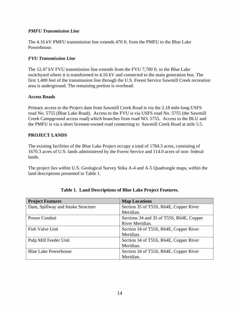
Primary access to the Project dam from Sawmill Creek Road is via the 2.18 mile-long USFS road No. 5755 (Blue Lake Road). Access to the FVU is via USFS road No. 5755 (the Sawmill Creek Campground access road) which branches from road NO. 5755. Access to the BLU and the PMFU is via a short licensee-owned road connecting to Sawmill Creek Road at mile 5.5. PROJECT LANDS The existing facilities of the Blue Lake Project occupy a total of 1784.3 acres, consisting of 1670.3 acres of U.S. lands administered by the Forest Service and 114.0 acres of non- federal lands. The project lies within U.S. Geological Survey Sitka A-4 and A-5 Quadrangle maps, within the land descriptions presented in Table 1.
Table 1. Land Descriptions of Blue Lake Project Features.
Project Features Map Locations Dam, Spillway and Intake Structure Section 35 of T55S, R64E, Copper River
Meridian. Power Conduit Sections 34 and 35 of T55S, R64E, Copper
River Meridian. Fish Valve Unit Section 34 of T55S, R64E, Copper River
Meridian. Pulp Mill Feeder Unit Section 34 of T55S, R64E, Copper River
Meridian. Blue Lake Powerhouse Section 34 of T55S, R64E, Copper River
Meridian.
14

Primary Transmission Line Section 33 & 34 of T55S, R64E, Copper River Meridian; Section 4, 5 and 6 of T56S, R64E, Copper River Meridian; Section 1 of T56S, R63E, Copper River Meridian; Section 35 & 36 of T55S, R63E, Copper River Meridian.
FEATURES EXPECTED to CHANGE or be ADDED UNDER BLUE LAKE PROJECT EXPANSION New Powerhouse and Turbines The current proposal is to replace the existing BLU powerhouse and two generators with a new powerhouse and two new generators. The new powerhouse, approximately 60 by 100 feet in area and 40 feet tall, would be located on Sawmill Creek’s left bank about 50 yards downstream from the existing BLU powerhouse (Figure 6), (green is an existing feature, red is a proposed feature). Exact plans for the decommissioning of the existing powerhouse and generators have not been developed at this time. The new powerhouse would house two new Francis turbine-generators with installed capacities of approximately 6 MW and 10 MW. The turbines would release water into an afterbay and then into Sawmill Creek via a tailrace similar to that at the existing powerhouse. Water Delivery to New Powerhouse The new powerhouse would require changes in the existing water delivery system. The existing lower penstock would bifurcate at the lower portal into a new 9.0 ft diameter penstock segment about 400 feet upstream from the new powerhouse (See Figure 6). Surge Chamber An underground 30-foot diameter surge tank would be constructed near the lower portal (Figure 7). The surge chamber would be vented to the surface at about El 470. The surge chamber would be necessary to decrease water pressure in the power conduit resulting from load rejection and a consequent pressure spike which might damage the power conduit and generating equipment. The surge tank would allow system operation at a higher average pressure and would improve the electrical frequency response of the Blue Lake Project. Switchyard A new switchyard would be constructed in the location of the existing switchyard next to the existing powerhouse (See Figure 6). The switchyard would transform the generation voltage (probably 13.8 kV) to transmission voltage (69kV) and would connect to the existing transmission line from the Green Lake powerhouse.
15
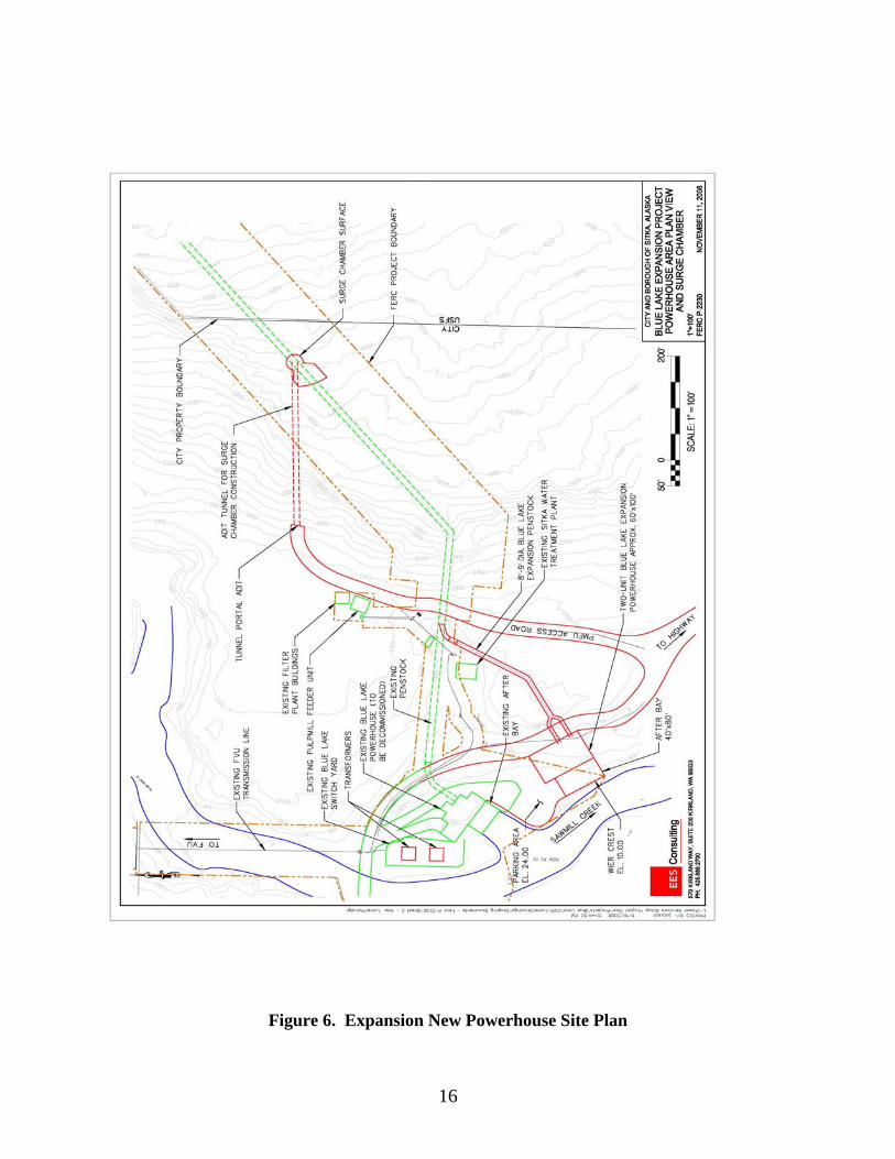
Figure 6. Expansion New Powerhouse Site Plan
16

Figure 7. Proposed Surge Chamber Profile
17

Proposed Dam Raising Dam Height Selection Preliminary geologic and engineering evaluations have suggested that the existing dam could be raised to El 425, (a raise of 83 feet above the existing spillway elevation) and that the existing dam would be competent to serve as the base of any dam structure rising to that height. While a dam height of El 425 appears to be at the geologic limit of the Sawmill Creek canyon, more detailed site-specific investigations will be necessary to exactly determine geologic constraints on ultimate dam height. It is the city’s goal to raise the dam to the highest structurally feasible level because each foot of increased dam height would generate an additional 415 megawatt/hours per year (MWh/yr) of electricity. A dam height of El 425 would increase the Blue Lake Project average annual generation by 54% Figure 9 shows an elevation view of the existing dam with spillway at El 342 and the proposed dam with spillway at El 425. At that height, the raised dam top width would be about 300 feet. Dam raise construction would generally be done using cranes positioned on the right abutment and on the existing dam (Figure 8). Access would be primarily via existing roads with some new road construction leading to the crane sites and staging areas. The primary staging area would be constructed by clearing an area on the hill north of the dam. Intake Structure Modifications The City is investigating modifications to the existing intake structure in Blue Lake (See Figure 9). The existing intake gate would be replaced with a new intake gate located in the power conduit and operated via a 245-foot vertical shaft. The invert at this gate would be at about El 190, or 12 feet lower than at the existing gate. The new intake gate would be designed for the increased head and would offer a more reliable seal than the existing gate. The existing intake gates and winch house would be removed from service but the intake trash rack would remain in service. Depending on the outcome of Blue Lake temperature simulations under raised dam depth conditions, the City is evaluating an alternate intake to provide warmer water for aquatic resources in Sawmill Creek and other uses. Details on the alternate intake have not been developed at this time
18

Figure 8. Elevation View of Existing and Expansion-Related Dam at El 425.
19

Figure 9. Plan View of Dam/Intake Area
20

Affected Reservoir Area and Energy Production Inundated area of Blue Lake reservoir would increase by approximately 35 percent with a dam height of El 425 (Table 2, Figure 10). Energy would increase by 35,000 MWh per year or 54 percent.
Table 2. Potential Energy and Inundated Area for Dam Height of El 425
Dam Height
Existing Reservoir Surface
Area (acres)
Additional Inundated
Area (acres)
Additional Inundated
Area (percent)
Existing Energy
Generation (MWh)
Energy Increase (MWh)
Energy Increase (Percent)
425 1,655 430 35 62,500
35,500 54
PROJECT OPERATION The City will conduct operations analyses which will retain all operating criteria, including instream flow releases, required under the new license. The City is prepared, using the operations simulation model used during relicensing, to evaluate other operational criteria at the request of resource agencies and other Stakeholders. ALTERNATIVE(S) EVALUATED BUT ELIMINATED FROM FURTHER CONSIDERATION Beginning in 2007, the City began feasibility studies to determine how to meet electrical load increases. Theses studies evaluated hydro, diesel, wind, tidal and geothermal energy. Generally, hydroelectric generation was considered the best alternative. It has a relatively low and predictable incremental cost and a predictable and well-developed regulatory environment. Hydroelectric generation uses very reliable equipment supplied and supported by well-established large scale industry. Use of diesel generation, as already demonstrated, results in dramatically higher rate-payer costs and has negative air quality and other environmental effects. It is anticipated that additional diesel generation will be required before the Blue Lake Expansion is online and the City is currently seeking to obtain an air quality permit for additional diesel generators. Wind, tidal and geothermal generation are attractive alternatives from an environmental standpoint, but, as untested technologies in Alaska, could not be installed soon enough or at a competitive cost to hydro. To increase Sitka’s hydroelectric generating capacity in the near term, expansion of the Blue Lake Project makes more sense than expansion of either the Green Lake Project or development of an entirely new hydro project. The Blue Lake Project is to some extent “under installed”
21

Figure 10. Plan View of Blue Lake Inundation with water surface at El 425
22

relative to Green Lake and has more water inflow than the existing turbines can use. The Blue Lake dam is in a canyon which could geotechnically support a significantly higher dam. The Green Lake project, while having more installed capacity, has a much smaller water inflow located at a site which does not favor adding additional reservoir capacity by dam raising. The City initially considered the Lake Diana hydroelectric project and applied for a Preliminary Permit (FERC No. 12716) to study the Project in July, 2006. The Preliminary Permit was ultimately surrendered because of Project cost and regulatory/environmental challenges related to developing a project in a designated wilderness area. The City has a Preliminary Permit for the Takatz Lake Project (FERC No. 13234) on the eastern coast of Baranof Island. This Project, with a proposed 27 MW installed capacity, has been under evaluation by the City for some time. The Takatz Lake Project capacity would be needed if Sitka energy needs continue to grow, but it’s construction schedule would be several years beyond that of the Blue Lake Expansion. The licensing and permitting process for the Takatz Lake project is expected to be much more extensive than amending the existing Blue Lake project license. The Blue Lake expansion, in terms of cost and regulatory feasibility, betters both Lake Diana and Takatz Lake among competing hydro sites. For these reasons, the City has settled on the Blue Lake expansion as the best alternative to meet Sitka’s critical energy needs quickly and at the least cost.
ENVIRONMENTAL RESOURCES, ISSUES and RECOMMENDATIONS
AFFECTED ENVIRONMENT Description of the Locale Physiography The Blue Lake Project area is on the west side of Baranof Island, a major component of the Alexander Archipelago in southeast Alaska. Baranof Island, with an area of 1569 square miles, is generally characterized in its northern half by rugged mountainous terrain and by more gentle, but still mountainous topography in its southern half. In the Project area, the Baranof Mountains rise to heights of over 4300 feet in the Blue Lake basin, and to over 5390 maximum on the island. The Blue Lake basin’s topography is the product of both glacial and riverine erosion. Climate The climate is the Project area is characterized as marine, with heavy precipitation and mild temperatures. The Blue Lake Project area’s temperature and precipitation differ significantly from data for those factors gathered at the Sitka airport. The airport NOAA weather station
23

shows that Sitka receives 86 inches of precipitation per year. Temporary rainfall monitoring done in the mountains near the Project powerhouse shows over 105 inches of precipitation per year. Average monthly temperature at the airport is 43F, and is expected to be somewhat higher than at the Project location. As with precipitation, temperature changes dramatically with elevation and is significantly lower in the mountains than at the elevations of both Blue Lake and Sawmill Creek. No long-term measured data are available for these areas. Geology and Soils Geology in the Project area was documented in detail prior to construction of the original dam, tunnel and powerhouse (Athern, 1954). In that report, the authors presented results of both surface investigations and numerous drill holes in the Project area and evaluated subsurface conditions and rock competency. No more recent geologic or soils information is available for the Project area. No additional geologic or soils surveys were conducted prior to construction of the small hydro features (FVU and PMFU) in the early 1990’s. Therefore, information from the Athern report is used in this section. The lowermost rocks in the Blue Lake area are a series of intricately folded, fractured, and recemented phyllite, graywacke, and argillite beds and lenses. These beds strike approximately North 60 degrees West and either dip very steeply to the southwest or stand vertically. They extend from approximately one mile below the lake outlet to some distance north and east from the inlet to the lake. Exposed by roadcuts along the highway leading east from Sitka is a layer of volcanic ash that rests on the glaciated bedrock surface. It is dark, chocolate brown in color and varies in thickness from a few inches to about 2.5 ft. Several light gray dioritic appearing dikes were mapped along the stream channel. Those observed ranged from 1 to 3 feet in width with exposures of limited later extent. Recent alluvium covers the valley floors, both above the lake and below the outlet to the shore of Silver Bay. The mountain slopes are very steep and overlain by very little overburden of alluvium except where small talus slides will lesser drainage channels. Considerable major and minor faulting has occurred in the Blue Lake–Sitka area. Two apparently major groups of faults trend northwesterly and easterly. One group of minor faults, no doubt associated with the major faulting, trending approximately east-west. Geology in the Blue Lake powerhouse area was said to be underlain by the same general sedimentary series. The soil layers in the Blue Lake basin are typically thin in the steep areas due to the steepness of the glacial cirque forming the lake. There are several slides and alluvial areas near the lakeshore. Very little vegetation is apparent due to the lack of soil and harsh
24

growing conditions around the lake. Soil conditions along the penstock route are similar to those at the lake. The soil in the Blue Lake Creek area is thicker and contains more vegetation. Water Resources Blue Lake Blue Lake is a 1225 acre water body impounded by the Project dam. Maximum depth of Blue Lake is about 468 feet, placing the lake bottom about 126 feet below sea level. (The Blue Lake basin was carved by glacial activity, resulting in this very deep lakebed point). Blue Lake is generally deeper in the middle and lower (toward the Project dam) areas. Maximum depth at the dam face is 134 feet, but average depth in the upstream end of the lake is only about 20 feet. At maximum pool elevation of El 342, the capacity of Blue Lake is approximately 145,200 acre feet (af). Clarity of Blue Lake water near the intake is very high, but, due to the glacial source of major inlet streams, is reduced in the upper end of the lake during periods of glacial melt. Most glacial material settles out in the upper areas of the lake. The quality of Blue Lake water in terms of dissolved solids or pollutants is exceptionally high, as evidenced by the fact that it serves as the City of Sitka’s drinking water supply and requires no additional filtration prior to consumption. The City and Borough of Sitka routinely monitors the quality of Blue Lake water. Typical monitoring results are presented in Table 3. Values for various inorganic, microbiological and volatile organic components are considered quite low. Table 3. Representative Concentrations Of Various Blue Lake Organic And Inorganic Contaminants. (City and Borough of Sitka Water and Wastewater Department data for Calendar Year 2003).
MICROBIOLOGICAL CONTAMINANTS
Contaminant Level Detected Total Coliform Bacteria None Turbidity None INORGANIC CONTAMINANTS Contaminant Level Detected Nitrate 1.0 ppm Flouride 4.0 ppm Arsenic NA Cyanide 0.2 ppm VOLATILE ORGANIC CONTAMINANTS Contaminant Level Detected Total Trihalomethane 80 ppb Bromodichloromethane NA Chloroform NA
25

Total Haloacetic Acids 60 ppb The temperature of Blue Lake water is somewhat variable, but generally reflects temperature regimes of other large lakes in Southeast Alaska. The City conducted temperature monitoring in Blue Lake and certain of its tributaries during 2002-2005 period (City and Borough of Sitka, 2005, 2006), resulting in data showing that that average surface temperatures vary between 2C and 12C (Figure 11). The 2005 studies indicated that Blue Lake stratified by late summer during the 2005 study season, and that water is uniform in temperature during the winter months.
Thermocline Composite
0
2
4
6
8
10
12
14
16
01/0
1/05
01/2
9/05
02/2
6/05
03/2
6/05
04/2
3/05
05/2
1/05
06/1
8/05
07/1
6/05
08/1
3/05
09/1
0/05
10/0
8/05
11/0
5/05
12/0
3/05
12/3
1/05
Date
Tem
p C
-15-30-45-60-75-90-105-120-135
Figure 11. Composite Blue Lake Temperatures at Various Depths, 2005 Blue Temperature Studies
Sawmill Creek Sawmill Creek flows from the base of the Blue Lake Project dam to tidewater, a distance of 2.03 miles. Sawmill Creek is a moderately sized stream relative to others in Southeast Alaska. Average annual flow in Sawmill Creek below the Blue Lake powerhouse is 441 cfs, ranging from an average low of 11 cfs in March to an average high of 1690 cfs which may occur from June to October each year depending on rainfall and snowmelt (Table 4, Figures 12 and 13). Recorded maximum flow in Sawmill Creek was 12,000 cfs in 1992. From the base of the Project dam to low mean sea level, Sawmill Creek descends 210 feet, for an overall gradient of 2 percent.
26

Table 4. Maximum and Minimum Average Daily Flows in Sawmill Creek, by Month, for 29-year Period of Record. Original USGS Gage 15088000.
Jan Feb Mar Apr May Jun Jul Aug Sep Oct Nov Dec Max 2,27
0 2,41
0 1,25
0 1,05
0 1,64
0 1,78
0 2,17
0 4,94
0 4,98
0 5,50
0 4,43
0 3,77
0 Min 24 16 11 14 57 308 311 200 71 84 46 34
Clarity of Sawmill Creek water is generally the same as for Blue Lake, particularly in the stream’s upper reaches, before inflow from tributary sub-basins. Sawmill Creek may carry a moderate sediment load during high flows (greater than 500 cfs) and after major rainstorms. Because of the overall good condition of the watersheds both above and below the Project dam, however, sediment input is moderate. The quality Sawmill Creek water is also considered to be quite high in terms of dissolved solids, pollutants, although there has been no long-term monitoring of Sawmill Creek water as there has been for Blue Lake. It is expected that Sawmill Creek becomes more turbid in a downstream direction after major rainstorms and that there may be in increase in certain organic solids related to inflow of leaf pack and other detritus. The City has monitored Sawmill Creek water temperature for approximately 2 years. Based on results of these studies, Sawmill Creek water temperatures range between 2C and 3C at the FVU and between 3C and 12C at the lower staff gage. This temperature regime characterizes Sawmill Creek as quite cold relative to other moderate-sized streams in Southeast Alaska, possibly because of the incised nature of the stream and resultant low solar insolation. Sawmill Creek temperature is affected by releases from the Project powerhouses (City and Borough of Sitka, 2006b). During spill periods, Sawmill Creek temperature is close to that measured at the Blue Lake surface. During non-spill periods, Sawmill Creek temperature is about the same as that at the level of the Project intake (about 140 feet deep) in Blue Lake (Figure 14). The Blue Lake Project Expansion would affect several water bodies, including Blue Lake, Sawmill Creek, Blue Lake Creek and several small tributaries to Blue Lake. Blue Lake Creek Blue Lake Creek is Blue Lake’s primary inlet stream, located at the extreme east end of the Lake. Blue Lake Creek arises near the spine of Mount Bassie and flows 4.5 miles to its confluence with Blue Lake. No stream gaging records are available for the stream but 54% of the total Blue Lake drainage area enter Blue Lake via Blue Lake Creek this is an average flow of 238 CFS. Blue Lake Creek’s headwaters from the lake to the upper barrier falls is about 10,000 feet in length, having a gradient of about 1%.
27
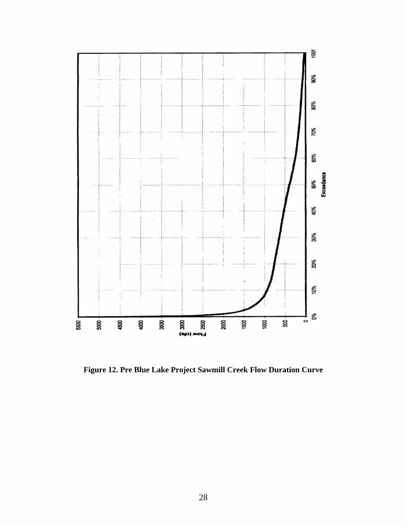
Figure 12. Pre Blue Lake Project Sawmill Creek Flow Duration Curve
28
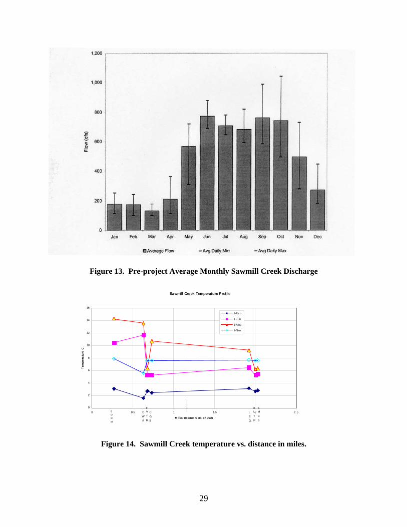
Figure 13. Pre-project Average Monthly Sawmill Creek Discharge
Sawmill Creek Temperature Profile
0
2
4
6
8
10
12
14
16
0 0.5 1 1.5 2 2.5
M iles Downst ream of Dam
Tem
pera
ture
C
1-Feb
1-J un
1-A ug
1-Nov
BOOM
DWR
FVTR
CGB
LSG
BLTR
SMCB
Figure 14. Sawmill Creek temperature vs. distance in miles.
29

Other Blue Lake Tributaries Blue Lake has several other potentially-affected tributaries, all of which are relatively small and short. These tributaries flow from small watersheds in many cases steeply down cliff areas or through high-gradient reaches. No detailed hydrologic or biologic studies have been conducted in these streams. The relative flows in these creeks have been estimated based on drainage areas. Blue Lake and Sawmill Creek Water Rights Following is a summary of the City & Borough of Sitka’s water rights and allocations for the Blue Lake watershed (Table 5).
Table 5. Current water rights relating to Blue Lake Project
Water Right
Use Amount Cfs equiv. MGD equiv.
Af/y equiv.
Status
ADL 51543
Hydro 191.4 mgd 296 191.4 214,343 Certificate
“ Drinking water
8.6 mgd 13.3 8.6 9,631 “
ADL 43826
Public industrial water supply
34,722 af/y
48 31 34,723 Certificate
LAS 19669 Bulk export/
14,000 af/yr
19.4 12.5 14,000 Certificate
“ Hydro 1,000 af/yr 1.4 0.9 1,000 “ LAS 11995 Fish
habitat Varies by month
Application
LAS 13236 FVU* 36,190 af/yr
50 32.3 36,190 Permit
LAS 13237 PMFU 56,000 af/yr
77.4 50 56,000 Permit
LAS 20526 BL/SMC* * These water rights correspond to Blue Lake level and Sawmill Creek release restrictions described in the previous license they are not corrected for the current license The City recently submitted a request to ADNR to amend the language of the various water rights in terms and units consistent with current ADNR practice (acre-feet per year with a maximum diversion rate in cubic feet per second) and to better reflect the City’s current use of Blue Lake water. At the time of this document, these requests are still pending for action at ADNR.
30

Fish and Aquatic Resources Sawmill Creek Sawmill Creek supports a variety of salmonid and other fish species, including salmon, steelhead and char. Numbers of certain salmon produced in Sawmill Creek are great enough to define Sawmill Creek as a regionally-important base for commercial salmon fisheries. The importance of Sawmill Creek trout and char species to the regional and local sport fisheries is more speculative because Sawmill Creek is not heavily used as a sport fishery relative to other fishing destinations in the region. Sources of information on Sawmill Creek fisheries distribution, abundance, habitat use and life history include the following:
Reports by Karl Wolfe of Sitka, a contractor to the City, documenting fish observations and captures in Sawmill Creek during 2001-2004 (Wolfe, 2002-2005);
A report by the City documenting fish life histories and time (“Periodicity”) for use in the
instream flow analyses related to relicensing (City and Borough of Sitka, 2004c);
The Alaska State Fisheries “Atlas”, a document, comprised of descriptive text and maps, which officially lists and shows the distribution the fish species which inhabit various streams and lakes in a region (ADF&G, 2005).
Information in this section is derived from these source reports and from communications with ADF&G personnel in Sitka regarding Sawmill Creek’s contribution to the area’s commercial and sport fisheries. General Description of Sawmill Creek Fishery Habitats Fish sampling was conducted within six stream reaches, established according to differences in fish habitat type, stream gradient or access considerations were developed (Table 6). Several project features referenced in this report are more fully described in the Initial Consultation Document (ICD, City and Borough of Sitka, 2002) and Scoping Document (SD1), City and Borough of Sitka, 2003.
The "Falls" referenced in the Reach designations is at Stream Mile (SM) 0.73 and is a major stream feature approximately 23 feet high. The "Slot", an area in which Sawmill Creek passes through an extremely narrow canyon constriction, is located from SM .95 to SM 1.06, and the FVU is the project powerhouse at SM 1.63 at which minimum stream flows are released into Sawmill Creek.
31
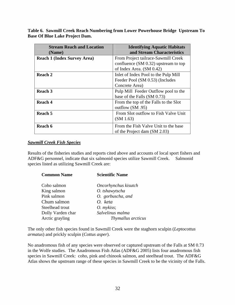
Table 6. Sawmill Creek Reach Numbering from Lower Powerhouse Bridge Upstream To Base Of Blue Lake Project Dam.
Stream Reach and Location (Name)
Identifying Aquatic Habitats and Stream Characteristics
Reach 1 (Index Survey Area) From Project tailrace-Sawmill Creek confluence (SM 0.32) upstream to top of Index Area. (SM 0.42)
Reach 2 Inlet of Index Pool to the Pulp Mill Feeder Pool (SM 0.53) (Includes Concrete Area)
Reach 3 Pulp Mill Feeder Outflow pool to the base of the Falls (SM 0.73)
Reach 4 From the top of the Falls to the Slot outflow (SM .95)
Reach 5
From Slot outflow to Fish Valve Unit (SM 1.63)
Reach 6 From the Fish Valve Unit to the base of the Project dam (SM 2.03)
Sawmill Creek Fish Species Results of the fisheries studies and reports cited above and accounts of local sport fishers and ADF&G personnel, indicate that six salmonid species utilize Sawmill Creek. Salmonid species listed as utilizing Sawmill Creek are:
Common Name Scientific Name Coho salmon Oncorhynchus kisutch King salmon O. tshawytscha Pink salmon O. gorbuscha, and Chum salmon O. keta Steelhead trout O. mykiss;
Dolly Varden char Salvelinus malma Arctic grayling Thymallus arcticus The only other fish species found in Sawmill Creek were the staghorn sculpin (Leptocottus armatus) and prickly sculpin (Cottus asper). No anadromous fish of any species were observed or captured upstream of the Falls at SM 0.73 in the Wolfe studies. The Anadromous Fish Atlas (ADF&G 2005) lists four anadromous fish species in Sawmill Creek: coho, pink and chinook salmon, and steelhead trout. The ADF&G Atlas shows the upstream range of these species in Sawmill Creek to be the vicinity of the Falls.
32

Pink Salmon Pink salmon are Sawmill Creek’s most abundant species. Average annual pink salmon escapement to Sawmill Creek is greater than 25,000 fish, reaching an observed maximum of over 36,000. Pink salmon have been observed throughout Sawmill Creek to the base of the Falls at SM 0.73 (Wolfe 2002-2005) but are typically most concentrated in the Sawmill Creek delta area downstream of the Blue Lake Powerhouse. Chum Salmon
Next in relative abundance among Sawmill Creek anadromous salmonids is the chum salmon. Estimated chum salmon numbers in Sawmill Creek have ranged from a low of about 250-300 chum in 2002 to a high of 8,000-9,000 chum in 2004 (Wolfe, 2003-2005). Chum salmon have become regionally important through production in local hatcheries, and increased use of their roe for salmon caviar.
King Salmon
King salmon are usually the next most abundant species of anadromous salmonid in Sawmill Creek. Annual escapements have ranged from about 180 in 2004 to 575 in 2003 (Wolfe 2002-2005). It is generally thought that Sawmill Creek king salmon are strays from a nearby hatchery. Emergency order sport fish regulations encourage the taking of king salmon in Sawmill Creek because of this factor. In Sawmill Creek, it is believed that king salmon fry rearing is limited due to a general lack of rearing habitat. No king salmon fry have been observed during the five seasons of study (Wolfe, 2002-2005). King salmon may remain in salt water for as many as six years. Coho Salmon
Although coho salmon have been observed throughout Sawmill Creek to the base of the Blue Lake Project dam at SM 2.03, no juveniles or adults were documented above the Falls at SM 0.73 during relicensing studies. Surveys from 2001-2004 indicated that Sawmill Creek coho numbers vary from a low of approximately 10 fish to possibly as many as 40 individuals during a typical escapement year (Wolfe 2002-2005).
Wolfe (2002-2005) found few juvenile coho in Sawmill Creek. He found relatively numerous juvenile rainbow trout and few Dolly Varden char in the same sampling areas. Sawmill Creek coho populations are probably limited by a lack of rearing habitat.
Steelhead Trout Steelhead trout are anadromous (ocean-going) variant of rainbow trout. Sawmill Creek steelhead populations have ranged from about 30-40 fish in 2002 and 2004 to 40-50 fish in 2003.
33

Resident Rainbow Trout Sawmill Creek fisheries surveys have consistently documented rainbow trout which could be either steelhead or residents. It is not possible, even with sophisticated genetic analyses, to distinguish between fish less than about 250mm. Larger rainbow trout (>250mm) observed in Sawmill Creek, however, are most likely resident. As discussed in the Blue Lake section below, rainbow trout have been introduced into Blue Lake on different occasions since the 1930’s, and may have spilled over Blue Lake Project dam into Sawmill Creek. Sawmill Creek resident rainbow trout are found throughout the stream but are concentrated in the reaches between the Project powerhouse and the base of the dam. Sawmill Creek rainbow trout populations support a moderate sport fishery. Adult rainbow move to spawning areas in early spring and are through spawning by early summer. Eggs overwinter incubate in the gravel and emerge as fry in September. Juveniles may remain in the creek for the remainder of their life, or become smolts and migrate to the ocean.
Larger resident rainbow trout prefer deeper water habitats in Sawmill Creek, especially those with access to more shallow swift water which provides a food source. Dolly Varden Char
Wolfe (2002-2005) studies show that Sawmill Creek supports small populations of anadromous and resident Dolly Varden char. Anadromous Dolly Varden in Sawmill Creek typically begin entering the stream in mid- to late July. Peak numbers of in-migrants were seen Wolfe (2002-2005) in early to late August. Anadromous Dolly Varden are known to follow salmon upstream and to consume salmon eggs shortly after deposition. Dolly Varden numbers tend to decline shortly after the end of the pink and chum salmon runs. Dolly Varden prefer small to medium gravel for spawning. Incubation probably takes 5- 6 months. Dolly Varden fry emerge from the gravel in April and May and are found near cover elements such as cobbles and boulders. Sport fishing for Dolly Varden char in Sawmill Creek is mostly coincidental while angling for other species such as king salmon and rainbow trout.
Blue Lake The primary fish species in Blue Lake is rainbow trout (O. mykiss). It is not known whether rainbow trout were native to the Sawmill Creek watershed prior to stocking by the U.S. Forest Service in 1938 and 1939. During this period 9,000 fry, 200 adult rainbow trout, and 50,000 eggs from Sashin Lake were planted in Blue Lake ( Der Hovanisian 1994) . After this initial planting, 8,800 rainbow trout from the Willamette River in Oregon were released in Blue Lake.
34

It is assumed that fish from these plantings spilled over the dam creating resident rainbow trout populations in Sawmill Creek. (ADF&G Sitka Sport fish Summary). The Blue Lake rainbow trout population has been estimated twice in recent years. Der Hovanisian (1994), using mark-recapture techniques, estimated the total Blue Lake rainbow trout population at 4708, ranging from 3197 and 7093 fish. The City and ADF&G conducted a similar mark-recapture study during summer, 2004, which resulted in an initial estimate of 3604, ranging between 2848 and 4361 fish (City and Borough of Sitka Electric Department, 2006a). The relatively large size and abundance of Blue Lake rainbow make this sport fishery comparable to the best available in southeast Alaska. Access to some extent limits overall fishing effort, but this limitation appears to have a moderating effect on fish take, resulting in both population and sport catch stability. Blue Lake rainbow trout spawn in lake tributaries and perhaps along shoreline areas with groundwater upwelling. Of Blue Lake’s four primary inflow tributaries, the three at the upper (northeastern) end of the lake probably support the majority of rainbow trout spawning. Spawning occurs in late spring and early summer and is usually complete by the beginning of July. Seasonal Blue Lake level does not appear to affect access to spawning tributaries. Wildlife and Botanical Resources Wildlife resources are described in this document in three categories: 1) large mammals, 2) small mammals 3) birds. Only three species of large mammals are known to inhabit the Blue Lake basin, including, among large mammals:
Common Name Scientific Name Brown bear Ursus arctos Mountain goat Oreamnos americanus Sitka black-tailed deer Odocoileus hemionus sitkensis A variety of small mammal species inhabit Baranof Island and may be found in the Blue Lake basin, including:
Common Name Scientific Name
River otter Lutra canadensis Pine marten Martes americana Beaver Castor canadensis Mink Mustela vison Red squirrel Tamiasciurus hudsonicus
Common shrew Sorex cinereus Tundra vole Microtus oeconomus
Short-tailed weasel Mustela erminea
35

Little brown bat Myotis lucifigus Forest deer mouse Peromyscus keeni
Birds expected to occur in the Project area are: Common Name Scientific Name Bald eagle Haliaeetus leucocephalus Dipper (Water ouzel) Cinclus mexicanus American merganser Mergus merganser americanus Willow ptarmigan Lagopus lagopus
Rock ptarmigan Lagopus mutus Mallard Anas platyrhynchos
Harlequin duck Histrionicus histrionicus Northern goshawk Accipiter gentilis Red-tailed hawks Buteo jamaicensis Western screech owl Otus kennicotti Marbled murrelet. Brachyramphus marmoratus Belted kingfisher Megaceyrle alcyon Raven Corvus corax Spruce hen Canachites canadensis
During annual migrations, several waterfowl species may use Blue Lake as a resting place, including trumpeter swan, tundra swan, pintail, green-wing teal, hooded merganser, northern shoveler, redhead and lesser and greater scaup, among other less abundant waterfowl species. Wetlands, Riparian, And Littoral Habitat While federal and state studies and listing do not show identified wetlands in the potentially-affected Project area, the City intends to conduct a Preliminary Jurisdictional Determination (PJD) to identify wetlands and waters of the US. Recreation And Land Use Recreation resources in the Blue Lake Project area are diverse, but, at present, not well documented. The major recreation activities are hiking, hunting, fishing and camping during the spring, summer and fall months. Sport Fishing Sport fishing is popular on both Blue Lake and Sawmill Creek, with Blue Lake offering the greater recreational opportunity. The Blue Lake/Sawmill Creek system offers perhaps the most accessible fresh water sport fishery to Sitka area residents, although access difficulties probably reduce overall recreational use of these areas. Fresh-water sport fishing in the Project area is primarily done by local area residents; the area is not known to attract large numbers of out-or-region anglers, as does the Sitka area marine king salmon fishery.
36

Blue Lake reservoir offers excellent rainbow trout fishing, primarily by boat access. The Sport Fish Division of ADF&G conducts post-season surveys of area anglers. Blue Lake surveys from 1984 through 2003 that numbers of Blue Lake anglers ranged from 48 to about 536 per year. Rainbow trout harvest during these years ranged from 47 to 1116. Blue Lake rainbow trout populations, as discussed in the Fish Resources section, above, have remained relatively stable over the past ten years. Rainbow trout fishing on Blue Lake is to some extent restricted by the lack of easy access, but, since Blue Lake is the City of Sitka’s domestic water supply source, heavy recreational use is not encouraged through maintenance of access and boat launch facilities. Sawmill Creek sport fishing effort is focused on steelhead in spring and early summer and king salmon in mid to late summer. Low steelhead populations in Sawmill Creek and difficult access to the most productive fishing areas limit the catch of this species. Only steelhead greater than 36 inches may be kept. Although no formal numbers are available, it is estimated (from BLU operator angler observations) that approximately 40 to 50 anglers harvest fewer than ten steelhead annually. Sawmill Creek king salmon fishing has improved recently, due to liberalized early season fisheries for this species. As discussed in the Fish Resources section, above, Sawmill Creek king salmon populations are thought to be largely of hatchery origin and are not likely to spawn in Sawmill Creek, making them favored sport fishing target species. Fishing for chum and pink salmon, while these species are periodically quite numerous, is not so intense as that for steelhead and king salmon. Small numbers of local anglers take Dolly Varden char in Sawmill Creek, but numbers and effort are largely unknown. Hunting Sport hunting in the Project area is popular with Sitka area residents. Hunting for Sitka black-tailed deer is probably the most popular pursuit, although numbers of hunters for all big and small game, and birds in the Project area are poorly known. Hunters use the Blue Lake road to provide access to black-tailed deer hunting, most frequently near the US Forest Service campground and Beaver Lake. Deer hunting is also facilitated by the road to Blue Lake, the Blue Lake access road and subsequent access to shoreline areas. The area surrounding Blue Lake Creek, the primary inflow to Blue Lake in its extreme eastern end is good overwintering habitat for black-tailed deer, but hunting effort in the area is not well documented. Deer hunting in the Project area is done under both sport and subsistence regulations (subsistence hunting numbers are discussed the section on that resource topic.)
37

Goat hunting is done primarily by accessing Blue Lake by boat and subsequent hiking to upslope areas of good goat habitat. Goat hunting, like black-tailed deer hunting, is done under both sport hunting and subsistence regulations. Hunting for small game and birds, primarily ptarmigan, is also done in the Project area. Steep terrain and limited access restrict these activities which are done by more hunters in other areas. Camping Camping in the Project area is limited to the USFS campground (called “Sawmill Creek Campground”) near the FVU. This area offers 11 campsites, restrooms and a parking lot. No RV hookups or other amenities are offered. The approximately 1 acre parking lot adjacent to the campground provides parking for day users and hikers. While USFS does not keep detailed records of campground use at this location, it is estimated that approximately 1000 people per year use the campground. General usership consists of overnight campers using primarily tents, and to a lesser extent RV’s, and day users seeking to picnic, hike nearby trails, or fish in Sawmill Creek or Beaver Lake. Significant vehicular travel in the area appears to result from visitors simply driving to and from the campground without leaving their cars. This use may relate to sightseeing along the Blue Lake road which offers dramatic canyon views, and, at the Blue Lake overlook, an expansive view of the lake itself. Within the area accessible to Sitka area residents and visitors, one other campground, the Starrigavin campground, which offers relatively easy road access. The Starrigavin campground provides for greater annual usership because of its easier access from the main Sitka road system. Hiking The USFS administers the Beaver Lake hiking trail which begins across the Sawmill Creek bridge from the Sawmill Creek campground. This 2 mile trail to Beaver Lake is a popular hiking destination. During 2004, the City and USFS began a use survey for the trail. Recording traffic counters were installed near the trailhead with the objective of determining number of hikers using the trail by season. In addition to the Beaver Lake traffic counters, the City also installed counters on the Blue Lake road to determine the number of hikers which use the road year around. Land Use Within/Adjacent to Project Boundary Land ownership and management within the Project area is complex, particularly in or near the primary transmission line route as it nears the community of Sitka. Generally, however, land
38
ownership in the Project area falls within three major categories: 1) US Forest Service, Tongass National Forest lands; 2) City and Borough of Sitka lands, 3) University of Alaska and Sheldon Jackson University lands, and 4) lands in private ownership (Figure 15) In the Sawmill Cove Industrial Park, various land parcels are leased to industries operating in the Park, including, at the time of this document, the True Alaska Bottling Company, Baranof Frozen Foods, Fortress of the Bears, Silver Bay Seafoods, Sitka Bike and Hike, and Theobroma Chocolate Company. Land use in the Project area generally follows the major ownership categories listed above. Tongass National Forest lands are managed under the Tongass Land Use Plan (TLMP) Lands under City ownership are used for power generation, water supply and commercial and industrial purposes, each administered by various City offices and departments. Among land use changes which might affect the amendment process is the NSRAA fish hatchery being constructed within the SCIP. Cultural Resources Three recent cultural resource investigations have been conducted in the Project Area: 1) The Blue Lake Road was surveyed by Charles Mobley (n.d.), 2) the campground area and site locations along the Sawmill Creek drainage were surveyed by Rabich Campbell (1989), and 3) cultural resources in the Project area were surveyed in 2005 by Paul Rushmore of Wrangell Associates, Wrangell Alaska, (Rushmore, 2005.) Mr. Rushmore’s studies included a literature review (including the sources cited above), consultation with the STA, USFS and ADNR, State Historic Preservation Officer (SHPO) and field surveys within the Area of Potential Effect (APE), defined by the Project Boundary. In addition, STA conducted interviews with tribal members. Results of the interviews indicated that certain traditional uses, primarily fishing and berry gathering, were impacted by construction of the APC mill and the Blue Lake Project. The interviews did not indicate Project-related impacts on or conflicts with known cultural sites, artifacts or other cultural/historical values known to the interviewees. None of the above surveys disclosed significant archaeological sites and all suggested that there is little potential for archaeological remains in the areas surveyed. Socio-Economic Resources Socio-economic effects of the Blue Lake expansion will be primarily on the City and Borough of Sitka, because of lack of population in the immediate Project area. Effects on the population would include those on workforce and economic development. Construction of the new powerhouse and raising the dam would take place over a period of 7 years, fielding a local
39

Figure 15. Land Use Map, Blue Lake Project Area
40
workforce of about 30 workers, many of whom could be from Sitka but some of whom would necessarily be from other areas, specifically contractors and specialists familiar with hydroelectric project design and construction. The primary socio-economic effects would be on Sitka’s prevailing electrical energy costs. As discussed earlier, without augmentation of Sitka’s current generating capacity, increased load growth without related hydro generation expansion would lead to increased diesel generation, at costs far exceeding those experienced with hydropower generation. Under current load growth forecasts, without additional hydroelectric generating capacity or other access to electricity (such as an electrical intertie), Sitka’s economy could be limited and population growth restrained by the cost of power. Scenic and Aesthetic Resources The Blue Lake Project area offers a variety of scenic and aesthetic opportunities. From the Blue Lake road turnoff to the Sawmill Creek campground, the drive along the Blue Lake road offers dramatic situations often characterized by exposure above the Sawmill Creek canyon and partial vistas of the surrounding mountains. At the Blue Lake overlook at road’s end there is an expansive view of Blue Lake itself and the surrounding mountains. As discussed in the recreation section, it is estimated that considerable visitation in this area is occurs solely for the purpose of sightseeing. Access on the Blue Lake road is often a factor limiting sightseeing. The road is generally maintained in good condition but may be made impassable by rock fall after landslides or downed trees after windstorms. The road is closed to vehicular traffic each winter due to avalanche dangers but the road is accessible to cross-country skiers, hikers and sledders. The parking area at the lake overlook is small. Threatened and Endangered Species No federally-listed Proposed, Endangered or Threatened (PET) species were found during the Blue Lake relicensing studies. Two species, humpback whale (Megaptera novaeangliae) and Stellar sea lion (Eumetopias jubata), are listed as respectively endangered and threatened in the marine environments of southeast Alaska. Both species are commonly encountered in Silver Bay and coastal Baranof Island. The marbled murrelet (Brachyramphus marmoratus) was noted during the Blue Lake studies, and was recently added to the T&E list for certain areas of southeast Alaska. The City, prior to amendment application, will complete a Biological Evaluation noting all endangered plant, fish and animal species in the Project area. Further, study plans botanical resources will note special surveys to be conducted for sensitive plants, to be conducted after final Project design. Subsistence Resources
41

Section 810 of the Alaska National Interest Lands Conservation Act (ANILCA) of 1980 requires an evaluation of effects to subsistence hunting, fishing, and gathering resources and the subsistence lifestyle for any project that uses federal public lands. Subsistence uses in the Project area include hunting, fishing, berry and other botanical gathering, and taking of certain shellfish. Subsistence Status of the General Area ANILCA created a preference for rural Alaska residents who use subsistence resources on federal public lands. Within the Blue Lake Project area, the USFS, ADF&G and USFWS regulate various aspects of subsistence hunting, fishing and gathering, depending upon the resource and location. The USFS controls subsistence hunts on its lands and is the only federal land manager involved in the project area. The Alaska Department of Fish and Game (ADF&G) controls hunting by urban, non-resident, and other non-rural hunters on these same lands and on any other land where hunting is allowed. Federal Public Land Affected Federal public land is land owned by the federal government that is open to the public and unencumbered by overlying selection by the State of Alaska or by Native corporations formed under ANILCA. All lands owned or operated by the federal government in the Blue Lake Project area are administered by USFS, Sitka Ranger District, Tongass National Forest. The total area of federal public land within the Project Boundary is about 1676 acres. Subsistence Communities and Their Resource Use Areas The nearest community, Sitka, is approximately 5 miles north of the Project Area. Sitka is a traditional subsistence community as defined by ANILCA or designated by the ADF&G, Board of Fisheries or Board of Game. This classification was recently reviewed because Sitka’s population increased beyond the level specified in ANILCA. In 1996, the ADF&G Division of Subsistence, in cooperation with STA, conducted a household subsistence survey in Sitka (among other southeast communities) to determine the fish, game and other resources used by subsistence users in the community (ADF&G, 1997). The survey showed that almost every Sitka household (97 percent) used at least one species of subsistence resources. Based on the sample, it is estimated that more than 1,746,463 pounds of wild resources were harvested by Sitka households from February 1, 1996 through January 31, 1997. Overall, the average Sitka household used 572 pounds of wild resources in the survey year, or about 205 pounds per person.
42

Fish contributed the major portion of the usable weight harvested (55 percent), while land mammals contributed almost 25 percent, marine invertebrates contributed 13 percent and vegetation contributed 3 percent (Table 7). Table 7. Estimated Total Subsistence Harvests of Wild Resources, Sitka, by Resource Category, February 1996 - January 1997 (Pounds of Usable Weight)
Subsistence Resource
Total Pounds
Harvested
Mean Pounds Per Household
Pounds Per
Person Fish 953,206 312 112 Land Mammals 434,971 142 51 Birds and Eggs 5,068 1 0.6 Marine Invertebrates
234,496 76 27
Marine Mammals 62,358 20 7 Vegetation 56,362 18 6
ENVIRONMENTAL ISSUES AND STUDIES Fisheries and Aquatic Resources Issues Issues
Issue F1. Effects of dam raising on Blue Lake rainbow trout and their ability to sustain their populations. This issue includes effects of the raised water levels on Blue Lake Creek and other Blue Lake tributaries and their potential for rainbow trout spawning.
Issue F2. Effects of the new powerhouse tailrace on Sawmill Creek anadromous fish populations, as related to attraction flow. Hydroelectric project tailrace outflows may differ from those in the adjacent stream channel in terms of water velocity, temperature or other factors. These differing factors may cause migrating salmonids to ascend the tailrace, at least temporarily, instead of the main stream channel. Design and operation of the tailrace may minimize these differences and reduce “false attraction” from the tailrace. Issue F3. Effects of construction of Expansion-related features on Blue Lake and Sawmill Creek water quality. The Blue Lake Expansion would involve extensive construction in or near Blue Lake and Sawmill Creek, with associated potential for sediment and other materials to affect water
43

quality. Construction and operation practices will need to be specified to reduce or preclude these construction-related effects on water quality.
Issue F4. Effects of Ramping Rates. Rapid changes of streamflow in the bypassed reach or below the tailrace have the potential to affect fish, particularly certain early life history stages. As was done during the relicensing, ramping rates (the rates at which streamflow may be raised or lowered) will be evaluated as part of the overall Project operation mode.
Issue F5. Effects of Water Temperature on Fish in Sawmill Creek . A deeper intake structure relative to the proposed higher dam might reduce water temperature in Sawmill Creek. Colder water might affect all life stages of anadromous and resident fish. Issue F6. Effects of entrainment at the Blue Lake Intake structure. The possibility of entrainment at the new intake will be analyzed, but the City feels that it is unlikely due to the depth of intake and absence of size classes of trout which might be subject to entrainment. Issue F7. Effects of sedimentation in Blue Lake Creek Increasing the elevation of Blue Lake will cause sedimentation in the potentially-inundated areas of Blue Lake Creek. This sedimentation may affect Blue Lake Creek fish habitat significantly. Under this Issue, the City will investigate the potential areas and depths of sedimentation to address effects on rainbow trout spawning other life history stages.
Studies During 2008 the City, through an approved contractor, has conducted baseline surveys of fish populations, their habitats and general life histories in potentially-affected water bodies described above. Draft study plans for the various areas were developed in coordination with Alaska state and federal resource agencies, including ADF&G, USFS, NMFS, FWS, NGOs, and affected tribes. General areas for these studies are described below: Blue Lake and Tributaries The City completed approved study plans for Blue Lake Creek and other tributaries to support analyses under Issue F1, above. The study plans include intensive surveys of Blue Lake and its tributaries in terms of fish occurrence and habitat utilization and measurement of physical habitat features including water temperature, stream channel structure, and other habitat features. All new studies on Blue Lake will be compared with the existing data base for that water body obtained during the recent FERC relicensing process.
44

Sawmill Creek Generally, the City proposed to utilize the existing data base for Sawmill Creek in association with observations of fish use and timing. During the 2008 anadromous fish activity season, foot surveys of Sawmill Creek were conducted to generally characterize fish species distribution, abundance and timing, as was done during the relicensing process. Wildlife Issues
Issue W1. Effects of Blue Lake dam raising on wildlife due to inundation and seasonal access changes. Whether raised Blue Lake water levels would inundate seasonal wildlife use in the affected areas, and the extent to which inundation would permanently affect flooded habitat. Of particular concern would be overwintering of mountain goats in the potentially-inundated area. Issue W2. Effects on mountain goat and black-tailed deer populations of increased access afforded by the dam raise. Whether higher Blue Lake water elevations might offer easier boat access than the current situation. Boat launch access is currently restricted due to difficulty in reaching the launch area, even during high water level in the fall. Easier boat access might promote an increase in hunting, particularly for goats and deer in the Blue Lake Creek basin. Issue W3. Disturbance Effects of Project Construction. Whether human access, blasting, excavations or other activities might disturb wildlife during the construction period of the various project expansion activities.
Studies
The City expects to utilize existing wildlife study results from the relicensing to provide a baseline for Sawmill Creek canyon. In addition, during 2008, the City’s wildlife contractor has competed intensive wildlife and habitat surveys in the potentially-inundated areas of Blue Lake. The contractor will prepare a report due in early 2009 which will include, for the potentially-inundated areas:
Ground surveys to determine large mammal distribution and abundance, habitat
utilization and food habits;
45

Small mammal trapping, to determine distribution and relative abundance of small mammals; and
Visual observations of birds and their nesting and feeding habitats. Botanical Resources
Issues
Issue BR1. Effects of inundation on plant communities in the Blue Lake Creek and other tributary basins. Whether raised lake levels will affect overall local and regional availability of plant communities and their associated wildlife habitats.
Issue BR2. Effects Of Construction and Inundation on Threatened, Endangered, or Sensitive Plant Species. Whether construction of Project features such as expected inundation, the new powerhouse, the dam raise, access roads or transmission corridors might affect these plant species.
Studies The City has extensive aerial imagery of the Blue Lake area, and has conducted a ground-truthed vegetation analysis of Blue Lake within an area approximately 200 feet around the existing high water level. Because of the extensive additional potentially-inundated areas, the City will expand on the current aerial data base. Using existing information and additional field observation as necessary the City will conduct:
Aerial inventories of vegetative type, primarily from existing imagery extended to include areas potentially inundated after dam raise;
Foot surveys, to ground-truth the aerial inventories in potentially-inundated areas; A Preliminary Jurisdictional Determination (PJD), to determine location, type, function
and extent of wetlands, uplands, and Waters of the US in the Project area; Prior to construction, the City will conduct sensitive plant surveys according to USFS prescriptions in potentially-affected areas delineated in the Project final design. Water Quantity
46

Issues
Issue Wquant 1. Effects of Blue Lake Expansion on Water Rights and Related Requirements. Whether instream flow or lake level regimes adopted during the license amendment process would affect existing permanent and conditional water rights in the potentially-affected river basins.
Studies Water quantity studies will include hydrologic studies of streamflow Blue Lake Creek and other Blue Lake tributaries, as deemed necessary. These studies may be based on field data or data synthesized from comparisons with measured data in nearby basins. Water Quality Issues
Issue Wqual 1. Effects of Raised Lake Level on Blue Lake Temperature Regimes. Whether the raised lake levels might affect the seasonal temperature regime, consequent yearly stratification and other limnological processes in Blue Lake and Sawmill Creek.
Issue Wqual 2. Effect of Project Construction on Water Quality in Blue Lake and Sawmill Creek. Whether construction of intake, powerhouse, access road(s) or transmission corridors might affect water quality in these water bodies. Effects might include changes in temperature, sedimentation, fuel spills, erosion or other factors relative to existing state water quality standards. Issue Wqual 3. Effect of Project Construction on Water Quality in Blue Lake as the City’s potable water source. Whether construction activities at and around Blue Lake would affect drinking water quality and how the effects may be mitigated.
Studies Water quality studies generally focus on characterization of the temperature, dissolved oxygen, dissolved solids and clarity (turbidity) of waters affected by the project. These water quality parameters are measured either continuously or periodically (seasonally, daily or weekly), using modern equipment capable of high accuracy and reliability.
47

The City intends to conduct water quality surveys of both Blue Lake and selected tributaries and Sawmill Creek. The City will determine the exact sampling methods, locations and frequency through the consultation process. Water quality study plans will be reviewed by Alaska state and federal resource agencies, including Alaska Department of Environmental Conservation (ADEC), the agency responsible for water quality standard compliance. Recreation Resources Issues Issue R1. Effect of Altered Access on Blue Lake Recreation Activities Whether increased boat access to Blue Lake resulting from raised water level would change the overall spectrum of recreation activities in the Blue Lake basin. Studies. The City has installed traffic counters at several locations along the Blue Lake road to determine use levels. In addition, the City has compiled recreation use data from the USFS and has observed recreation use in the Blue Lake Creek valley as part of other resource studies in that area. Geology and Soils Issues
Issue GS1. Geotechnical feasibility of Project works. Whether surface and subsurface conditions, including bedrock, soils and slope materials might affect feasibility of construction of Project features as proposed. Including the proposed shoreline of Blue Lake Issue GS2. Existence of mineral claims. Whether ground disturbance or access restrictions associated with Project construction or operation might affect existing mineral claims, especially in previously-noted mining areas.
Studies As part of the NEPA process, the City will query the Bureau of Land Management for any mineral claims prior to building any structures or otherwise blocking access to potentially valuable deposits. The results of this preliminary study would provide a geotechnical review of any geologic features that would be incorporated into any of the constructed features. Cultural Resources
48

Issues
Issue C1. Effects of new powerhouse and Dam Raise Construction on Cultural Resources in the Area of Potential Effect. Whether construction-related disturbance might affect previously-unidentified cultural properties. In particular the Pande Basin mine access road
Studies In compliance with Section 106 of the National Historic Preservation Act, the City will consult with USFS, the SHPO and the federally-recognized Sitka Tribe of Alaska to determine Cultural resource issues, availability of information, and studies to be performed. In fall, 2008, the City, through an approved contractor, conducted a survey of cultural and historical resources with emphasis on the potentially-inundated areas of Blue Lake. These surveys were part of a two-Stage process: Stage I involved less-intensive reconnaissance surveys designed to define the direct and indirect impact area of the project and the potential of the areas for containing sites. Stage II surveys were conducted in those areas identified in the stage I surveys as having a reasonable likelihood of containing sites. The scope of all 2008 survey work was determined through an agency and Tribe approved study plan. Scenic and Aesthetic Resources Issues
Issue SA 1. Effects of Blue Lake Dam raising construction and long term operation on aesthetic values within the Blue Lake viewshed. Whether raising the dam by 83 feet, and associated inundation, would significantly affect the aesthetic values as viewed from both the road terminus and on the lake itself. Issue SA 2. Effects of the new powerhouse construction and operation on aesthetic values in lower Sawmill Creek. Aesthetic values in the Sawmill Creek area are initially lower than those in or near Blue Lake, but are in many areas unique, particularly in the canyon areas in the bypassed reach. Expansion-related aesthetics effects on these areas, while not so extensive as those near Blue Lake will be evaluated.
Studies The City will research existing aesthetic resource information including the TLMP and ANILCA descriptions and designations to distinguish among aesthetic impacts in the various potentially-affected areas. Viewshed analyses may be available or may be required to evaluate effects in
49

different areas. All constructed Project features will be evaluated relative to USFS and other stakeholder prescriptions for maintenance of aesthetic values. In addition, a viewshed analysis of Blue Lake from various viewing locations will be conducted. This analysis will utilize computer and photo image based techniques to simulate visual changes related to various dam heights and viewing locations. Socioeconomics
Issue SE1. Effects of license amendment-related changes for non-developmental resources on economics, particularly electric rates within the Electric Department’s service area, and related effects on Sitka cost of living. An increase in electric rates might effect the overall quality of life in Sitka through cost impacts on both residences and businesses. Under this issue, the City would evaluate the effects of streamflow and lake level constraints on electrical rates.
Threatened and Endangered Species.
Issue T and E1. Effects of the expansion amendment on threatened and endangered species. Section 7 of the Endangered Species Act requires that all federal agencies, in consultation with the US Fish and Wildlife Service and National Marine Fisheries Service ensure that their actions are not likely to jeopardize the continued existence of threatened or endangered species or adversely modify their habitat. Under this issue, the City will consult with appropriate federal and state agencies to determine whether listed threatened or endangered species might occur within the area potentially affected by Project construction or long-term operation, and, if such species are found, to assure that project expansion does not adversely affect these species.
Subsistence Resources
Issue Sub1. Effects of project expansion on subsistence related resources. Alaska statutes identify groups and individuals qualifying to take or otherwise utilize resources for subsistence purposes. Generally, the City believes that Project development will not affect existing or future subsistence uses in the Project area, but will discuss existing uses and their related entitlements in all subsequent environmental and amendment application documents. The City will specifically address whether altered access in the Blue Lake area will affect existing subsistence uses.
CUMULATIVE EFFECTS
50

51
According to FERC NEPA implementation regulations (§1508.7), an action may cause cumulative impacts on the environment if its impacts overlap in space and/or time with the impacts of other past, present and reasonably foreseeable future actions, regardless of what agency or person undertakes such other actions. Cumulative effects can result from individually minor but collectively significant actions taking place over a period of time to include hydropower and other land and water development activities.
TEMPORAL SCOPE Cumulative analyses will include past, present, and future actions and their effects on aesthetic, recreational, fisheries and wildlife resources. Based on the 30-year term of the recently issued new license, the temporal scope will look 30 years into the future, concentrating on environmental effects from reasonably foreseeable future actions which may be identified during Scoping.
GEOGRAPHIC SCOPE The geographic scope of analysis for the resources that could be cumulatively affected is defined by the physical limits or boundaries of: 1) the proposed action’s effect on the resource; and 2) contributing effects from other hydropower and non-hydropower activities. Since the actions affect the resources differently, the geographic scope for each resource may vary. The exact geographic scope of cumulative effects analysis will be determined through further consultation with resource agencies, and from comments received during Scoping. CUMULATIVELY AFFECTED RESOURCES Resources which might be cumulatively affected by the Expansion include: Recreation. Since the Blue Lake basin offers such accessible and generally desirable recreation opportunities, Expansion-related changes in access might affect recreation over a larger area of Baranof Island. This evaluation will include all activities noted in the recreation section above, with respect to their current and expected future use levels and locations. Alluvial Valley Bottom Forests. Blue Lake Creek Valley is one of the few remaining alluvial, valley bottoms that have not been clear-cut logged on the Tongass National Forest’s Sitka Ranger District (the others of significance being the Indian River Valley and the Salmon Lake Valley). The City will examine whether inundation of this valley and the loss of 420 acres would be a significant cumulative impact on such ecosystems within the geographic scope of cumulative analyses.

APPLICABLE COMPREHENSIVE PLANS The following five comprehensive state and federal management plans were identified as relevant during the Blue Lake Project relicensing. During the amendment application process, further investigations into relevant plans will be conducted.
1. City of Sitka Comprehensive Plan (CSCP). City and Borough of Sitka;
2. Sitka Coastal Management Plan. Alaska Department of Natural Resources;
3. Tongass Land Use Management Plan. United States Forest Service, Tongass National Forest, Juneau;
4. Northern Southeast Area Plan, Alaska Department of Natural Resources;
5. Sitka Trail Plan, USFS, Sitka Trailworks, City and Borough of Sitka, ADNR, STA,
National Park Service, Sitka National Historic Park;
6. Sawmill Cove Industrial Park Plan. City and Borough of Sitka Water Front Development Plan. City and Borough of Sitka; and
7. Sitka Non-Motorized Transportation Plan. City and Borough of Sitka.
During the amendment application process, we plan to fully address enforceable policies and conditions of all plans to determine consistency of Project proposals and alternatives with Plan conditions. We seek any input from the applicable agencies or others which might aid in our review of Comprehensive Plans during amendment application process.
52

REFERENCES ADF&G. 2006a. Catalog of Waters Specified as Important for the Spawning, Rearing, or Migration of Anadromous Fishes. ADF&G, Anchorage, AK. ADF&G. 2006b. Atlas to the Catalog of Waters Specified as Important for the Spawning, Rearing or Migration of Anadromous Fishes. ADF&G, Anchorage AK. Alaska Department of Fish and Game, 1997. Wild Food Resource Harvests in Sitka, Results of a Household Survey, 1996. Alaska Department of Fish and Game, Division of Subsistence, Juneau AK. 5pp. Athearn, Murray J. 1954. Preliminary Report on the Geology of the Blue Lake Project Near Sitka, Alaska. United States Department of the Interior Bureau of Reclamation, Alaska Geologic Report No. 4, Alaska Investigation Office, Juneau, Alaska 18pp. Bovee, Kent. 2005. Wildlife Investigations for 2004-2005. In Support of Blue Lake Project (FERC No. 2230) Relicensing. Prepared For: City And Borough Of Sitka Electric Department, Sitka, AK. June, 2005. 20 pp plus Appendix. Bovee, Kent. 2006. Wildlife Investigations for 2005. In Support of Blue Lake Project (FERC No. 2230) Relicensing. Prepared for: City And Borough Of Sitka Electric Department, Sitka, AK. February, 2006. 16 pp plus Appendix. City and Borough of Sitka 1990. Application for Amendment of License for the Blue Lake Hydroelectric Project, FERC No. 2230. Prepared by: R.W. Beck and Associates. City and Borough of Sitka Electric Department, 2005g. Blue Lake Water Temperature and Rainbow Trout Spawning Studies 2002-2004. Blue Lake Hydroelectric Project FERC No. 2230. City and Borough of Sitka Electric Department, Sitka, Alaska. City and Borough of Sitka Electric Department, 2006a (In Press). Population Estimation of Adult Rainbow Trout in Blue Lake Near Sitka, Alaska, 2004. Prepared by: City and Borough of Sitka, Alaska, Electric Department In Support of: Blue Lake Hydroelectric Project (FERC No. 2230) Relicensing
City and Borough of Sitka Electric Department 2006b. 2005 Sawmill Creek and Blue Lake Water Temperature Studies. Blue Lake Hydroelectric Project, FERC No. 2230. City and Borough of Sitka Electric Department Sitka, Alaska March, 2006. de Laguna, F. 1960. The Story of a Tlingit Community: A Problem in the Relationship between Archaeological, Ethnological, and Historical Methods. Bureau of American Ethnology Bulletin No. 172. U.S. Government Printing Office, Washington, D.C. de Laguna, F. 1991. Tlingit. In: Handbook of North American Indians, Vol. 7: Northwest Coast, W. Suttles, ed., pp 203-228. Washington D.C.: Smithsonian Institution.
53

54
Der Hovanisian, J. A. 1994. Stock assessment of rainbow trout in a southeast Alaska impoundment. Juneau: University of Alaska. Thesis. Krause, A. 1956. The Tlingit Indians: Results of a Trip to the Northwest Coast of America and the Bering Straits, translated by Erna Gunther. The American Ethnological Society, Monograph 26, University of Washington Press, Seattle. Rabich-Campbell, C. 1989 An Archaeological Survey of the Blue Lake Small Hydro Additions, Sitka, Alaska. Report prepared for R.W. Beck and Associates, Seattle, WA.. Rushmore, Paul, 2005. Archaeological Assessment of the Blue Lake Project, Sitka, Alaska, Final Report. Prepared for: Blue Lake Hydroelectric Project (FERC No. 2230) Relicensing, City and Borough of Sitka Electric Department, June 1, 2005. Prepared by: Wrangell Research Associates, Wrangell, Alaska. 17pp. Wolfe, Karl 2002. Fisheries Survey Annual Report, Sawmill Creek, 2001. Blue Lake Project, Federal Energy Regulatory Commission (FERC) No. 2230. City And Borough Of Sitka, Licensee. Prepared By: Karl Wolfe, Sitka, AK. January, 2002. 22pp
Wolfe, Karl. 2003. Sawmill Creek Fisheries Survey Annual Report For 2002 Studies. Blue Lake Project, Federal Energy Regulatory Commission (FERC) No. 2230. City And Borough Of Sitka, Licensee. Prepared By: Karl Wolfe, Sitka AK. March, 2003. 41 Pp
Wolfe, Karl. 2004. Sawmill Creek Fisheries Survey Annual Report For 2003 Studies. Blue Lake Project, Federal Energy Regulatory Commission (FERC) No. 2230. City And Borough Of Sitka, Licensee. Prepared By: Karl Wolfe, Sitka AK., April, 2004, 41pp
Wolfe, Karl. 2005. Sawmill Creek Fisheries Survey Annual Report For 2004 Studies, Blue Lake Project, (FERC) No. 2230. Prepared For: City And Borough Of Sitka Electric Department, Relicensing Agent, March, 2005. 46pp

ATTACHMENT I
PARTICIPANT LIST
BLUE LAKE EXPANSION AMENDMENT
City and Borough of Sitka, AK, 5/15/09
Carole Goularte, District Ranger U.S. Forest Service 204 Siginaka Way Sitka, AK 99835 (907) 747-4218 [email protected] Roger Birk, R10 Hydropower Team U.S. Forest Service P.O. Box 21628 Juneau, AK 99802-1628 907-586-8843 [email protected] Ken Coffin, Supervisory Biologist U.S. Forest Service 204 Siginaka Way Sitka, AK 99835 907-747-4343 [email protected] Lisa Gassman Sitka Tribe of Alaska 456 Katlian St. Sitka, AK. 99835 907-747-7500 [email protected]
Heather Woody, Research Biologist Sitka Tribe of Alaska 456 Katlian St. Sitka, AK. 99835 907-747-6506 ext. 10 [email protected] Jim Ferguson Hydropower Coordinator Alaska Department of Fish and Game 333 Raspberry Road Anchorage, AK. 99518 907-267-2312 [email protected] Shawn Johnson, Fishery Biologist Alaska Department of Fish and Game Sport Fish Division P.O. Box 110024 Juneau, AK. 99811-0024 907-465-4302 [email protected] Bob Chadwick, Area Sport Fish Biologist ADF&G Sport Fish Division 304 Lake Street, Room 103 Sitka, AK. 99835-7563 907-747-5551 [email protected]
Scoping Document II Blue Lake Project (FERC No. 2230) Expansion City and Borough of Sitka Electric Dept. June 2009
55

Richard Enriquez U.S. Fish and Wildlife Service 3000 Vintage Boulevard, Suite 201 Juneau, AK. 99801 907-780-1162 [email protected] Susan H. Walker Marine Resources Specialist Habitat Conservation Division National Marine Fisheries Service P.O. Box 21668 Juneau, Alaska 99802-1668 907-586-7646 [email protected] Erin Allee Alaska Department of Natural Resources, Alaska Coastal Management Program PO box 111030 Juneau, AK 99811-1030 907-465-8790 [email protected] John Dunker Alaska Department of Natural Resources Division of Water 400 W. Willoughby Avenue Juneau, AK. 99801-1724 907-465-2533 [email protected] Jackie Timothy Dept. of Natural Resources, OHMP P.O. Box 111050 Juneau, AK. 99811-1050 (907) 465-4275 [email protected]
Brenda Krauss Alaska Department of Environmental Conservation Division of Water 410 Willoughby Ave, Ste. 303 Juneau, AK. 99801 907-465-5321 [email protected] Judith Bittner State Historic Preservation Officer 550 West Seventh Avenue, Suite 1310 Anchorage, AK. 99501-3565 907-269-8715 [email protected] Dan Hess U.S. Geological Survey P.O. Box 1568 Juneau, AK. 99801 907-586-7216 [email protected] John Klutz U.S. Army Corps of Engineers P.O. Box 6898 Elmendorf AFB, AK. 99506-6898 800-472-2712 [email protected] Andrew Thoms, Executive Director Sitka Conservation Society Box 6533 Sitka, AK 99835 907-747-7509 [email protected]
Scoping Document II Blue Lake Project (FERC No. 2230) Expansion City and Borough of Sitka Electric Dept. June 2009
56
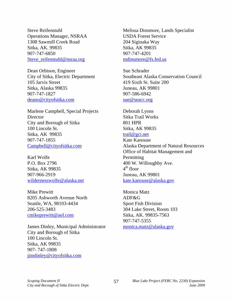
Steve Reifenstuhl Operations Manager, NSRAA 1308 Sawmill Creek Road Sitka, AK. 99835 907-747-6850 [email protected] Dean Orbison, Engineer City of Sitka, Electric Department 105 Jarvis Street Sitka, Alaska 99835 907-747-1827 [email protected] Marlene Campbell, Special Projects Director City and Borough of Sitka 100 Lincoln St. Sitka, AK 99835 907-747-1855 [email protected] Karl Wolfe P.O. Box 2796 Sitka, AK 99835 907-966-2919 [email protected] Mike Prewitt 8205 Ashworth Avenue North Seattle, WA, 98103-4434 206-525-3483 [email protected] James Dinley, Municipal Administrator City and Borough of Sitka 100 Lincoln St. Sitka, AK 99835 907- 747-1808 [email protected]
Melissa Dinsmore, Lands Specialist USDA Forest Service 204 Siginaka Way Sitka, AK 99835 907-747-4201 [email protected] Sue Schrader Southeast Alaska Conservation Council 419 Sixth St. Suite 200 Juneau, AK 99801 907-586-6942 [email protected] Deborah Lyons Sitka Trail Works 801 HPR Sitka, AK 99835 [email protected] Kate Kanouse Alaska Department of Natural Resources Office of Habitat Management and Permitting 400 W. Willoughby Ave. 4th floor Juneau, AK 99801 [email protected] Monica Matz ADF&G Sport Fish Division 304 Lake Street, Room 103 Sitka, AK. 99835-7563 907-747-5355 [email protected]
Scoping Document II Blue Lake Project (FERC No. 2230) Expansion City and Borough of Sitka Electric Dept. June 2009
57

Troy Tydingco ADF&G Com Fish Division 304 Lake Street, Room 103 Sitka, AK. 99835-7563 907-747-6688 [email protected] Paul Carson Currents Consulting 11045 Exeter Ave NE Seattle, WA 98125 206-440-5433 [email protected] Mark Buggins Environmental Director City and Borough of Sitka 100 Alice Loop Sitka, AK 99835 907-966-2256 [email protected] Christopher Brewton Utility Director City of Sitka, Electric Department 105 Jarvis Street Sitka, Alaska 99835 907-747-1870 [email protected] William Guey-Lee, Chief Engineering & Jurisdiction Branch Division of Hydropower Administration & Compliance 888 First St. NE Washington, DC 20426 Phone: 202-502-6064 Fax: 202-219-2732 [email protected]
Carrie (McMullen) Bohan Environmental Program Specialist III Southeast Drinking Water Program Office 410 Willoughby #303 Juneau, AK 99801 (907) 465-5333 phone (907) 465-5362 fax [email protected] Kent Bovee Biologist 210 A Marine St. Sitka, AK 99835 (907) 752-0710 [email protected] Floyd Tomkins [email protected] Margaret Beilharz USFS R10/R6 Hydropower Team McKenzie Bridge, OR 97413-9612 541-822-7228 [email protected] Gary Prokosch ADNR Water Resources [email protected] Terry Schwarz ADNR Water Resources [email protected] David Gann DNR DCOM [email protected] Stefanie Ludwig DNR [email protected]
Scoping Document II Blue Lake Project (FERC No. 2230) Expansion City and Borough of Sitka Electric Dept. June 2009
58

Perry Edwards USFS 204 Siginaka Way Sitka, AK 99835 907-747-4220 [email protected] Anji Russell City of Sitka 105 Jarvis St. Sitka, AK 99835 [email protected] Buck Lindekugel Southeast Alaska Conservation Council [email protected] Barth Hamberg USFS 204 Siginaka Way Sitka, AK 99835 907-747-6671 [email protected] Patrick Regan P.E. Federal Energy Regulatory Commission Portland Regional Office 805 SW Broadway, Suite 550 Portland, OR. 97205 (503) 552-2741 [email protected] Kim de Rubertis Consulting Engineer PO Box 506 Cashmere, WA 98815 509-782-3434 [email protected] Keith Cox [email protected]
Larry Nesheim [email protected] John Flory [email protected] Jeff Feldpausch Resources Protection Director Sitka Tribe of Alaska 208 Lake St. Sitka, AK 99835 907-747-7469 Fax 907-747-7506 [email protected] Justin Nettle P.E Federal Energy Regulatory Commission Portland Regional Office 805 SW Broadway, Suite 550 Portland, OR. 97205 (503) 552-2741 [email protected] Robert Loiselle President & CEO Shee Atika, Inc 315 Lincoln Street, Suite 300 Sitka, AK 99835 907-747-3534 [email protected] Ron Wolfe Natural Resources Manager Sealaska Corporation One Seaalaska Plaza, Suite 400 Juneau, AK 99801 907-587-1512 [email protected]
Scoping Document II Blue Lake Project (FERC No. 2230) Expansion City and Borough of Sitka Electric Dept. June 2009
59

ATTACHMENT II
STAKEHOLDER COMMENT LETTERS and RESPONSES
In the following Attachments, we present the comment letters from USFS and SCS. Because of the extensiveness of the SCS comment letter, and because most SCS comments did not require a change in between SD1 and SD2, the SCS comments are addressed in the body of the comment letter, also in Attachment II. Responses to the individual comments are in italics, underlined, directly below the respective comments. Only SCS comment 3 required a change in reflected in SD2 (addition of a Cumulative Effects Section), and is noted in the response. The USFS comments were numbered (in parentheses, bolded) for later reference. Reponses to these numbered comments are listed in Attachment III, noting how the comment was addressed and locations of changes in the Scoping Document.
Scoping Document II Blue Lake Project (FERC No. 2230) Expansion City and Borough of Sitka Electric Dept. June 2009
60
Sitka Conservation Society “Working to protect the natural environment
of the Tongass, and Sitka’s quality of life – Since 1967”
Box 6533 Sitka, Alaska 99835 (907) 747-7509 ph [email protected] www.sitkawild.org
Dec. 15, 2008 SCOPING COMMENTS, SD1 AND SCOPING MEETING, BLUE LAKE PROJECT (FERC No. 2230) EXPANSION AMENDMENT PROCESS To Whom It May Concern: On behalf of the 240 Sitka households and the 260 out-of-state members, I would like to submit the following comments outlining issues we would like to see addressed in the permitting process.
1. Socioeconomic/ Environmental/ Need for Action: Potential Impact on global climate change.
a. Is part of the rational for this project to displace and/or offset the use of hydro-carbons due to their adverse impact to the global climate?
Response: Rationale for the Blue Lake Expansion is primarily to develop a renewable energy source to avoid dependence on petroleum-based generation and its associated costs. Environmental effects of hydroelectric generation, in terms of hydrocarbon avoidance, air quality standards and climate change, are a welcome added benefit.
b. What is the potential for this project to offset the use of hydrocarbons and thus
have a measurable impact on global climate change?
Response: It is impossible to state the extent to which this project would have a measurable impact on global climate change.
i. Tons of carbon displaced by not generating electricity with diesel? Response: The Expansion Project would generate 35,000 megawatt hours (MWh) of energy per year more than the existing Project. Based on EPA Bulletin AP42, 10/92, Table 3.4-1, 35,000 MWh of diesel generated power would produce 28,644 tons/year CO2.
Scoping Document II Blue Lake Project (FERC No. 2230) Expansion City and Borough of Sitka Electric Dept. June 2009
61

ii. Tons of carbon displaced by Sitka residences who would heat their homes with electricity rather than oil?
Response: The Expansion Project’s additional 35,000 MWhr/yr of energy, if used to displace energy generated by diesel fuel used for space heating in 75% efficient furnaces, would generate about 13,367 tons of CO2 per year.
iii. Tons of carbon displaced by Sitkans who would potentially use electric
cars rather than gas-powered, internal combustion vehicles?
Response: The Table in response to Item “c”, below estimates that by 2020 there will be approximately 4841 passenger cars in Sitka, of which 2420, or about 50 per cent, will be electric. The Table also estimates that each car, whether electric or gas powered, will drive about 4380 miles per year. Total passenger car miles in 2020, then, will be 21,203,580 miles. Gas powered passenger vehicles produce between 0.6 (Prius) and 1.6 (large SUV) pounds of carbon per mile. For simplicity in this estimate, we will use 1.0 pound per mile of carbon as a rough average. This would result, in the Sitka case, in about 21,000,000 pounds of carbon per year produced by petroleum-fueled passenger cars. If this amount were reduced by half (due to half of Sitka’s cars being electric by 2020), the total carbon reduction would be about 10,500,000 pounds or 6000 tons of carbon per year. This, however, would only be the case if all battery recharge electrical power were generated using hydroelectricity. For every increment of diesel required, this benefit would be reduced. If electric car recharging required diesel-based electricity, the overall carbon reduction benefits would be greatly reduced. Clearly, the optimum situation would result from as high a number of electric cars as could be fully recharge-supported by hydroelectric-based electrical generation.
a. What is the actual offset of hydrocarbons (with best estimate calculations for the
above questions) with the current City hydroelectric facilities (by specific facility)
Response:
The Blue Lake Project produces about 65,000 MWh per year and the Green Lake Project produces about 59,000 MWh per year of electricity. Diesel generators with a 35 per cent efficiency (like those currently used by Sitka), generate about 0.8 ton of CO2 per year for each MWh per year of electricity generated. The Blue Lake and Green Lake Projects, then, would respectively offset about 52,000 and 47,000 tons of CO2 per year, for a total of 99,000 tons.
Scoping Document II Blue Lake Project (FERC No. 2230) Expansion City and Borough of Sitka Electric Dept. June 2009
62

b. Based on the most recent demand study, what is the best estimate of the breakdown of homeowners electric use (appliances, home heating, electric car, etc)?
Response: In Sitka it is estimated that an average residence uses 720 kilowatt hours ( kWh) per month for appliances, lights and hot water. If the residence has electric heat, the consumption is an additional 1000 kWh per month. It is estimated that an electric car used in Sitka would use about 164 kWh per month for battery recharging.
c. How will the demand for electric energy to power electric cars increase in Sitka
over the next 10 years based on best estimates of national market estimates of the introduction rates of electric cars and the current actual electric car trend in Sitka?
Response: Table 13, below, is from a 2008 Electric Load Forecast study done by D. Hittle and Associates for the City. It shows that the load for electric car battery recharging will be 4,418,325 kWh by 2020. This represents about 2.8 percent of total forecast load (158,000 MWh, including electric cars) at that time.
Scoping Document II Blue Lake Project (FERC No. 2230) Expansion City and Borough of Sitka Electric Dept. June 2009
63

d. How will the timber harvest, sale of timber, and processing of cleared timber
related to the clearing of the inundation zone be conducted to maximize socio-economic benefits to the community of Sitka?
Response: The exact specifications of the timber harvest and sale are yet to be worked out between the US Forest Service and the City. We expect to negotiate these details prior to submission of the final Amendment Application, in spring, 2010.
Scoping Document II Blue Lake Project (FERC No. 2230) Expansion City and Borough of Sitka Electric Dept. June 2009
64

j. Subsistence and Recreation
a. How do Sitkans use the upper valley of the Blue Lake Basin for recreation and subsistence activities—especially hunting, fly-fishing, hiking, camping, goat hunting, bird watching, solitude, remote recreation, etc?
Response: We assume that, by “upper valley of the Blue Lake Basin” you are referring to the upper valley of the Blue Lake Creek Basin. Exact estimates of use of this valley are not available. It is known that there is limited use of the valley for fishing, camping, hiking, camping and hunting (primarily for goats), but neither the City nor the US Forest Service (USFS) have quantified use levels. Generally, it is felt that use of the valley is limited. It is known that goat hunting is popular in the valley. ADF&G estimates that about 10 goats are harvested annually in areas accessed via Blue Lake Creek valley, and that this harvest would correspond to a approximately 20 hunters, given and estimated 50 percent success rate. Perhaps the best recent estimate of use through the spring, summer and fall months are found in reports from the City’s fisheries and wildlife, botanical and cultural contractors, who collectively reported seeing a total of fewer than 12 recreationers during more than 50 person-days afield during 2008.
b. What opportunities will exist for recreation/subsistence activities in the Blue Lake
Basin post-project?
Response: Exact Expansion-related changes in recreation facilities, access restrictions and other regulations are not known at this time. These issues will be addressed in the PDEA and DEA prior to the final Amendment Application.
c. Is there a potential for mitigating options to replace the potential loss of
recreational opportunities such as trail construction, recreation access improvement, habitat restoration, etc.
Response: Mitigating opportunities relative to recreation impacts will be explored during development of Preliminary and Final Terms and Conditions. All Stakeholders will be able to propose these measures in writing to both FERC and to the City and other Stakeholders. The City will request Preliminary Terms and Conditions from Stakeholders prior to distribution of the PDEA, and, to the extent possible,
Scoping Document II Blue Lake Project (FERC No. 2230) Expansion City and Borough of Sitka Electric Dept. June 2009
65

evaluate and negotiate those measures as part of the final Amendment Application.
k. Cumulative Impacts: Alluvial, valley bottom forests
a. Although the Blue Lake Valley may not represent a regionally unique plant community/ecosystem type, it is one of the few remaining alluvial, valley bottoms that have not been clear-cut logged on the Tongass National Forest’s Sitka Ranger District (the others of significance being the Indian River Valley and the Salmon Lake Valley). Will the inundation of this valley and the loss of 420 acres be a significant cumulative impact given the extent of clear-cut harvest of these forest/plant community types? If so, do mitigating factors exist to deal with that loss such as permanent protection of similar valleys in others close to Sitka and/or habitat restoration to return valleys to pre-harvest conditions?
Response: A Cumulative Effects Section has been added to SD2. Impacts to alluvial valley-bottom ecosystems have been added as a cumulatively affected resource on pages 50 and 51 of the SD2 and will be addressed in the Preliminary Draft Environmental Assessment.
Thank you for the opportunity to submit these comments. Andrew Thoms Executive Director Sitka Conservation Society
Scoping Document II Blue Lake Project (FERC No. 2230) Expansion City and Borough of Sitka Electric Dept. June 2009
66
USFS COMMENT LETTER
File Code: 2770-2 Date: February 2, 2009
Kimberly D. Bose Secretary Federal Energy Regulatory Commission 888 First Street NE
Subject: USDA Forest Service – Tongass National Forest, Sitka Ranger District Scoping
Comments, SD1 and Scoping Meeting, Blue Lake Project (FERC No. 2230) Expansion
Amendment Process
Dear Secretary Bose:
We have reviewed the Blue Lake Hydroelectric Project Expansion, FERC No. 2230 Scoping
Document 1 (SD1) and offer the following comments.
Sawmill Creek Fish Species (USFS 1)
Page 34, Resident Rainbow Trout. Rainbow Trout eggs do not overwinter.
Cultural Resources, page 39. (USFS 2)
We are in receipt of the draft report of the Archeological Assessment prepared by Mr. Rushmore.
On September 22, 2005 via letter we provided comments on the draft report in connection with
the relicensing process. Our records do not indicate a final report was distributed or our
Scoping Document II Blue Lake Project (FERC No. 2230) Expansion City and Borough of Sitka Electric Dept. June 2009
67

comments addressed. Has an Alaska Heritage Resource Survey Records number been acquired
and a National Register of Historic Places (NRHP) evaluation been completed for the corduroy
road noted in the assessment? A copy of any concurrence letter(s) regarding this report and this
sites eligibility would be helpful in providing substantive comments.
Resource Issues Not Identified in Scoping Document 1 (USFS 3)
Subsistence Resources – Access (USFS 3a)
Section 811 of the Alaska National Interest Lands Conservation Act (ANILCA) requires that
rural residents engaged in subsistence uses have reasonable access to subsistence resources on
public lands. The subsistence analysis will need to include a distinct finding on whether the
proposed action may significantly restrict access to subsistence resources.
Recreation Resources (USFS 3b)
The City acknowledged at the December 11, 2008 scoping meeting that Recreation Resources
were inadvertently left out of the Scoping Document. Our interest is whether or not proposed
project expansion operations will affect recreational activities and opportunities within or
adjacent to the project area. For example, the effects of increased access to Blue Lake on lake
based recreation.
The USFS operates the Sawmill Creek campground and administers the Beaver Lake hiking
trail. The Thimbleberry Lake-Heart Lake Trail lies within the transmission line corridor. Other
recreational activities such as fishing on Blue Lake and Sawmill Creek, and hunting (goats and
Sitka black-tailed deer), are known to take place on national forest lands accessed from the Blue
Lake road and by boat from Blue Lake.
Scoping Document II Blue Lake Project (FERC No. 2230) Expansion City and Borough of Sitka Electric Dept. June 2009
68
The Final Recreation Resources Study Plan was completed in November 2008. Results of
recreation resources studies may result in identification of additional issues.
Thank you for the opportunity to comment. Please address all inquires and comments regarding
this filing to Carol Goularte, Sitka District Ranger by phone 747-4218; or by email at
[email protected] or Melissa Dinsmore, Lands Specialist by email at [email protected];
by phone at 747-4201.
Sincerely, /s/Forrest Cole
FORREST COLE Forest Supervisor cc: Dean Orbison, Engineering Manager, CBS Electric Department
Scoping Document II Blue Lake Project (FERC No. 2230) Expansion City and Borough of Sitka Electric Dept. June 2009
69

Scoping Document II Blue Lake Project (FERC No. 2230) Expansion City and Borough of Sitka Electric Dept. June 2009
70
ATTACHMENT III
USFS COMMENTS SUMMARY TABLE Comments of US Forest Service (USFS) Comment Number Comment Summary Response and Location
USFS 1 Comment that rainbow trout eggs do not overwinter
Text on page 35 modified, “overwinter” replaced with “incubate”.
USFS 2 Requests documentation that NRHP concurrence has been obtained on the Corduroy Road
City cultural contractor sent concurrence letter to USFS.
USFS 3a Suggests that Subsistence section address whether access to subsistence activities will be affected.
p. 51. Language added to address access issue.
USFS 3b USFS notes their interest in inclusion of Recreation Issues
Recreation issues added in SD2, page 49.