schedule of proposed action (sopa) 10/01/2017 to 12/31 ... · pdf filetransylvania, watauga,...
TRANSCRIPT
10/01/2017 10:15 am MT Page of1 National Forests In North Carolina 25
National Forests In North Carolina, Occurring in more than one District (excluding Forestwide)
This report contains the best available information at the time of publication. Questions may be directed to the Project Contact.
Project PurposeProject Name DecisionPlanning Status Project ContactExpected
Implementation
10/01/2017 to 12/31/2017
R8 - Southern Region
- Wildlife, Fish, Rare plants - Vegetation management (other than forest products)
- Land management planning
Completed
In Progress:NOI in Federal Register 03/12/2014Est. DEIS NOA in Federal Register 09/2017
Actual: 06/01/2017
Expected:04/2018
David [email protected]
Heather [email protected]
UNIT - Cheoah Ranger District, Grandfather Ranger District, Pisgah Ranger District, Appalachian Ranger District, Nantahala Ranger District, Tusquittee Ranger District. STATE - North Carolina. COUNTY - Mitchell, Swain, Transylvania, Yancey, Avery, Buncombe, Burke, Caldwell, Cherokee, Clay, Graham, Haywood, Henderson, Jackson, McDowell, Macon, Madison. LEGAL - Not Applicable. Nantahala and Pisgah NFs.
UNIT - Cheoah Ranger District, Grandfather Ranger District, Pisgah Ranger District, Appalachian Ranger District, Nantahala Ranger District, Tusquittee Ranger District. STATE - North Carolina. COUNTY - Mitchell, Swain, Transylvania, Watauga, Yancey, Avery, Buncombe, Burke, Caldwell, Cherokee, Clay, Graham, Haywood, Henderson, Jackson, McDowell, Macon, Madison. LEGAL - Not Applicable. 18-county area in Western North Carolina.
Location:
Location:
06/2017
04/2018
Emerald Ash Borer Treatment Project
Nantahala and Pisgah NFs Plan Revision
Schedule of Proposed Action (SOPA)
The proposed action is to use chemical and biological treatments on ash trees on the Nantahala and Pisgah NFs that are at risk of infestation of the nonnative emerald ash borer.
Revision of the Nantahala and Pisgah NFs Land and Resource Management Plan (Forest Plan)
Description:
Description:
Web Link:
Web Link:
http://www.fs.usda.gov/project/?project=51502
http://www.fs.usda.gov/goto/nfsnc/nprevision
National Forests In North Carolina
CE
EIS

10/01/2017 10:15 am MT Page of2 National Forests In North Carolina 25
National Forests In North Carolina, Occurring in more than one District (excluding Forestwide)
National Forests In North Carolina Appalachian Ranger District (excluding Projects occurring in more than one District)
Project PurposeProject Name DecisionPlanning Status Project ContactExpected
Implementation
R8 - Southern Region
R8 - Southern Region
- Forest products - Vegetation management (other than forest products)
- Special use management
- Watershed management - Road management
In Progress:Scoping Start 09/22/2017Est. Comment Period Public Notice 11/2017
In Progress:Scoping Start 10/08/2007
Developing ProposalEst. Scoping Start 10/2017
Expected:01/2018
Expected:09/2012
Expected:05/2018
Sarah [email protected]
Linda [email protected]
Brady [email protected]
UNIT - Cheoah Ranger District, Tusquittee Ranger District. STATE - North Carolina. COUNTY - Cherokee, Clay, Graham. LEGAL - Not Applicable. Selected areas on the Tusquitee and Cheoah Ranger Districts, Cherokee, Clay, and Graham Counties, North Carolina.
UNIT - Appalachian Ranger District. STATE - North Carolina. COUNTY - Mitchell, Yancey, Avery, Buncombe, Haywood, Madison. Appalachian Ranger District.
UNIT - Appalachian Ranger District. STATE - North Carolina. COUNTY - Buncombe. LEGAL - Not Applicable.The project is located from just upstream of the FSR231 and FSR74 junction downstream to the FSR74 bridge crossing.
Location:
Location:
Location:
03/2018
09/2012
07/2018
Tusquitee and Cheoah DistrictsVine Control EA
Appalachian RD Special Uses CE/DM
Corner Rock Creek Stream Enhancement Project
Initiate a programmatic EA authorizing vine control treatments in areas exposed to full sunlight by natural and human-induced disturbances, including timber management, where high vine density is negatively impacting reforestation.
The proposed action is to issue district-wide special use permits, typically for research and filming.
The proposal action includes to stabilizing stream banks, placement of large wood and boulders, and improving Forest Service Road 74 to reduce damage and erosion.
Description:
Description:
Description:
*NEW LISTING*
*NEW LISTING*
EA
CE
CE
10/01/2017 10:15 am MT Page of3 National Forests In North Carolina 25
National Forests In North Carolina Appalachian Ranger District (excluding Projects occurring in more than one District)
Project PurposeProject Name DecisionPlanning Status Project ContactExpected
Implementation
R8 - Southern Region
- Wildlife, Fish, Rare plants
- Recreation management
- Recreation management - Wildlife, Fish, Rare plants - Forest products - Fuels management - Watershed management - Road management
Completed
In Progress:Objection Period Legal Notice 08/23/2017
In Progress:Scoping Start 07/14/2016Est. Comment Period Public Notice 05/2018
Actual: 08/08/2017
Expected:10/2017
Expected:10/2018
Christopher [email protected]
David [email protected]
Jason [email protected]
UNIT - Appalachian Ranger District. STATE - North Carolina. COUNTY - Madison. LEGAL - Not Applicable. The project area includes the Mills Ridge Fields as well as the Cook Fields that are located off of Highway 25/70 near Hot Springs.
UNIT - Appalachian Ranger District. STATE - North Carolina. COUNTY - Mitchell. LEGAL - Not Applicable. South Toe Trail Head.
UNIT - Appalachian Ranger District. STATE - North Carolina. COUNTY - Haywood. LEGAL - Not Applicable. Project area is all forest service lands of the Appalachian Ranger District South-west of Interstate 40. Project areais approximately 10,695 acres (8,935 Forest Service Lands).
Location:
Location:
Location:
08/2017
10/2017
03/2019
Mills Ridge and Cook Fields Mastication
South Toe Trail Head Expansion
Twelve Mile Project
The proposed action includes mastication of brush (mostly Autumn Olive)to expand and maintain existing wildlife openings.
The proposed action is to expand the parking area at the South Toe trailhead.
Landscape level project to implement Nantahala and Pisgah National Forest Land and Resource Management Plan with an additional focus on restoration needs and elk habitat improvement.
Description:
Description:
Description:
Web Link:
Web Link:
Web Link:
http://www.fs.usda.gov/project/?project=52272
http://www.fs.usda.gov/project/?project=49334
http://www.fs.usda.gov/project/?project=48776
*NEW LISTING*
*UPDATED*
*UPDATED*
CE
EA
EA

10/01/2017 10:15 am MT Page of4 National Forests In North Carolina 25
National Forests In North Carolina Appalachian Ranger District (excluding Projects occurring in more than one District)
National Forests In North Carolina Cheoah Ranger District (excluding Projects occurring in more than one District)
Project PurposeProject Name DecisionPlanning Status Project ContactExpected
Implementation
R8 - Southern Region
R8 - Southern Region
- Wildlife, Fish, Rare plants
- Land management planning - Vegetation management (other than forest products) - Fuels management
- Recreation management - Wildlife, Fish, Rare plants
- Special use management
On Hold
In Progress:Scoping Start 09/19/2017
Developing ProposalEst. Scoping Start 10/2017
Completed
N/A
Expected:12/2017
Expected:11/2017
Actual: 09/26/2017
David [email protected]
Chad [email protected]
Jason [email protected]
Robert [email protected]
UNIT - Appalachian Ranger District. STATE - North Carolina. COUNTY - Yancey. Appalachian RD, FSR 472.
UNIT - Cheoah Ranger District. STATE - North Carolina. COUNTY - Swain, Graham. LEGAL - Not Applicable. Twenty one separate units totaling approximately 6,413 acres in Graham and Swain counties in North Carolina.
UNIT - Cheoah Ranger District. STATE - North Carolina. COUNTY - Graham. LEGAL - Not Applicable. Cheoah Work Center, Graham County, NC.
UNIT - Cheoah Ranger District. STATE - North Carolina. COUNTY - Graham. LEGAL - Not Applicable. Adjacent to US Highway 129 in Graham County, NC.
Location:
Location:
Location:
Location:
N/A
01/2018
11/2017
10/2017
White Pine Cabin Removal
Cheoah Ranger District Prescribed Burn Program
Cheoah Work Center Pond Rehabilitation Project
Duke Energy Phase 3 Project
The proposed action is to remove, deconstruct, or burn White Pine cabin and garage.
Reauthorize prescribed burning on 21 separate units totaling approximately 6,413 acres in Graham and Swain counties in North Carolina for two burning cycles or up to 10 years; treatments would be subject to a new environmental review in 2023.
Rehabilitate a small pond at the Cheoah Work Center by removing silt and excess aquatic vegetation to improve fish habitat.
Grant a special use authorization to Duke Energy to upgrade the electrical distribution system to Phase 3 capacity on National Forest System lands adjacent to US Highway 129 in Graham County, NC.
Description:
Description:
Description:
Description:
*NEW LISTING*
*NEW LISTING*
*NEW LISTING*
CE
CE
CE
CE

10/01/2017 10:15 am MT Page of5 National Forests In North Carolina 25
National Forests In North Carolina Cheoah Ranger District (excluding Projects occurring in more than one District)
Project PurposeProject Name DecisionPlanning Status Project ContactExpected
Implementation
R8 - Southern Region
- Special use management
- Recreation management - Watershed management - Road management
- Special use management
- Special use management
On Hold
Completed
In Progress:Scoping Start 07/18/2017
In Progress:DEIS NOA in Federal Register 08/29/2008Est. FEIS NOA in Federal Register 03/2018
N/A
Actual: 06/06/2017
Expected:11/2017
Expected:03/2020
Karen [email protected]
Steverson Moffat828 837-5152 [email protected]
Robert Vance828-837-5152 [email protected]
Karen [email protected]
UNIT - Cheoah Ranger District. STATE - North Carolina. COUNTY - Graham. LEGAL - Not Applicable. NC 143 from the Cherohala Skyway to SR1127 at Robbinsville.
UNIT - Cheoah Ranger District. STATE - North Carolina. COUNTY - Graham. LEGAL - Not Applicable. Two locations on Santeetlah Road (MP 3.63 and MP 8.80), Cheoah Ranger District, Graham County, NC.
UNIT - Cheoah Ranger District. STATE - North Carolina. COUNTY - Graham. LEGAL - Not Applicable. National Forest System lands in Graham County, North Carolina.
UNIT - Cheoah Ranger District. STATE - North Carolina. COUNTY - Graham. LEGAL - Not Applicable. US Highway 74 from Stecoah to Robbinsville.
Location:
Location:
Location:
Location:
N/A
07/2017
12/2017
03/2021
NC 143, NCDOT Project
Santeetlah Road Repairs Project
Thrash Meetinghouse Road Easement
US Highway 74 (A-9) Project Sections BA and CA, NCDOT Project
NCDOT has proposed making improvements to NC 143 from the Cherohala Skyway to SR1127 at Robbinsville in Graham County. Portions of this project are located on National Forest system lands.
Conduct repairs to two sections of the Santeetlah Road (Forest Service Road 81) on the Cheoah Ranger District inGraham County, NC.
Grant access across National Forest System lands on the Cheoah Ranger District in Graham County, North Carolina, on two existing Forest Service Roads and by allowing construction of two short road segments for vehicular access to private lands.
The proposed action is to relocate US Highway 74 from Stecoah to Robbinsville and widen the road to four lanes.
Description:
Description:
Description:
Description:
Web Link: http://www.fs.usda.gov/project/?project=7529
*NEW LISTING*
EA
CE
CE
EIS
10/01/2017 10:15 am MT Page of6 National Forests In North Carolina 25
National Forests In North Carolina Croatan Ranger District (excluding Projects occurring in more than one District)
Project PurposeProject Name DecisionPlanning Status Project ContactExpected
Implementation
R8 - Southern Region
- Special use management
- Special use management
- Special use management
- Special use management
In Progress:Scoping Start 07/10/2014
On Hold
In Progress:Objection Period Legal Notice 09/13/2017
In Progress:DEIS NOA in Federal Register 01/22/2016
Expected:09/2018
N/A
Expected:11/2017
Expected:09/2018
Donald [email protected]
Donald [email protected]
Donald [email protected]
Karen [email protected]
UNIT - Croatan Ranger District. STATE - North Carolina. COUNTY - Carteret, Craven, Jones. LEGAL - Not Applicable. Croatan National Forest in Craven, Carteret and Jones Counties. Various locations throughout.
UNIT - Croatan Ranger District. STATE - North Carolina. COUNTY - Craven. LEGAL - Not Applicable. Intersection of Highway 101 and Temples Point Road in Craven County, North Carolina.
UNIT - Croatan Ranger District. STATE - North Carolina. COUNTY - Craven. LEGAL - Not Applicable. This project occurs on the Croatan National Forest in Craven County, NC in the Perrytown Community. More sepcifically it occurs between Brice's Creek and FS Road 121A.
UNIT - Croatan Ranger District. STATE - North Carolina. COUNTY - Craven. LEGAL - Not Applicable. Havelock Bypass, US 70, near the city of Havelock, NC.
Location:
Location:
Location:
Location:
10/2018
N/A
12/2017
10/2018
Carolina T&T (CenturyLink)Existing Special Use Permit Renewal
Church Sign for Calvary Church
Coastal Carolina Regional Airport Runway Safety Improvement Project
Havelock Bypass, US 70, NCDOT Project
The Carolina T&T (CenturyLink) permit is for the operation and maintenance of overhead and buried phone lines crossing various sections of the Croatan National Forest.
The proposed action is to approve a special use permit to allow the Calvary Church to place a sign in a road right-of-way the Forest Service owns near the intersection of Highway 101 and Temples Point Road in Craven County, North Carolina.
The proposal is to ammend the special use permit with the Coastal Carolina Regional Airport to allow removal of vegetation obstructions in the glide path approack of the runway.
NCDOT has proposed construction of a US 70 bypass around Havelock, NC.
Description:
Description:
Description:
Description:
Web Link:
Web Link:
Web Link:
Web Link:
http://www.fs.usda.gov/project/?project=44543
http://www.fs.usda.gov/project/?project=42426
http://www.fs.usda.gov/project/?project=40283
http://www.fs.usda.gov/project/?project=21694
*UPDATED*
*UPDATED*
*UPDATED*
CE
CE
EA
EIS
10/01/2017 10:15 am MT Page of7 National Forests In North Carolina 25
National Forests In North Carolina Croatan Ranger District (excluding Projects occurring in more than one District)
National Forests In North Carolina Grandfather Ranger District (excluding Projects occurring in more than one District)
Project PurposeProject Name DecisionPlanning Status Project ContactExpected
Implementation
R8 - Southern Region
R8 - Southern Region
- Wildlife, Fish, Rare plants - Forest products - Vegetation management (other than forest products) - Fuels management
- Wildlife, Fish, Rare plants - Vegetation management (other than forest products) - Fuels management
- Special use management
In Progress:Scoping Start 03/28/2014Est. Comment Period Public Notice 07/2018
On Hold
On Hold
Expected:09/2018
N/A
N/A
Steven [email protected]
Heather [email protected]
Donald [email protected]
UNIT - Croatan Ranger District. STATE - North Carolina. COUNTY - Carteret. LEGAL - Not Applicable. Croatan National Forest just to the west of Newport, NC.
UNIT - Croatan Ranger District. STATE - North Carolina. COUNTY - Carteret, Craven, Jones. On various sitesof the Croatan National Forest.
UNIT - Croatan Ranger District. STATE - North Carolina. COUNTY - Carteret. LEGAL - Not Applicable. From Pringle Road proceeding along Forest Route 155, Deep Sand Road, on the Croatan Ranger District.
Location:
Location:
Location:
10/2018
N/A
N/A
Newport Project
Revised EA for Control of the Southern Pine Beetle on Croatan National Forest
West Carteret New Water Well Installation
The proposed project consists of various timber, wildlife and fire related treatments to move toward the desired future condition of Longleaf pine and provide improved habitat for the Federally Endangered Red-cockaded Woodpecker
The proposed action is to control outbreaks of southern pine beetle on pine stands using Integrated Pest Management techniques.
Allow the West Carteret Water Corporation to place 2 more water wells and approximately 4000 feet of additional waterline with power on the Croatan Ranger District in the locations identified in their existing permit issued in August of 1989.
Description:
Description:
Description:
Web Link:
Web Link:
Web Link:
http://www.fs.usda.gov/project/?project=37454
http://www.fs.usda.gov/project/?project=26350
http://www.fs.usda.gov/project/?project=42677
*UPDATED*EA
EA
CE

10/01/2017 10:15 am MT Page of8 National Forests In North Carolina 25
National Forests In North Carolina Grandfather Ranger District (excluding Projects occurring in more than one District)
Project PurposeProject Name DecisionPlanning Status Project ContactExpected
Implementation
R8 - Southern Region
- Special area management - Wildlife, Fish, Rare plants
- Vegetation management (other than forest products)
- Special use management
On Hold
Completed
On Hold
N/A
Actual: 07/24/2017
N/A
Gary [email protected]
Nicholas [email protected]
Linda [email protected]
UNIT - Grandfather Ranger District. STATE - North Carolina. COUNTY - Burke, McDowell. Linville Gorge Wilderness.
UNIT - Grandfather Ranger District. STATE - North Carolina. COUNTY - Burke, Caldwell, McDowell. LEGAL -Not Applicable. Areas within the designation of insect and disease infestation landscape area.
UNIT - Grandfather Ranger District. STATE - North Carolina. COUNTY - McDowell. LEGAL - Not Applicable. Permitting of existing unnamed road for access to private property.
Location:
Location:
Location:
N/A
08/2017
N/A
Control of Non-Native Invasive Plant Species in the Linville Gorge Wilderness
Crawley Branch Southern Yellow Pine Restoration Project
Dennie Easement
The proposed action is to treat non-native invasive plant species in the Linville Gorge Wilderness using a combination of manual and chemical treatments.
The proposed action includes a combination of stand improvement, commercial thinning, regeneration, and prescribed burning to reduce the risk and increase resilience to southern pine beetle outbreak.
The proposed action is to grant access to private land.
Description:
Description:
Description:
Web Link:
Web Link:
Web Link:
http://www.fs.usda.gov/project/?project=37735
http://www.fs.usda.gov/project/?project=47869
http://www.fs.usda.gov/project/?project=48796
*UPDATED*
*UPDATED*
EA
CE
CE

10/01/2017 10:15 am MT Page of9 National Forests In North Carolina 25
National Forests In North Carolina Grandfather Ranger District (excluding Projects occurring in more than one District)
Project PurposeProject Name DecisionPlanning Status Project ContactExpected
Implementation
R8 - Southern Region
- Recreation management
- Vegetation management (other than forest products) - Fuels management
- Special use management
In Progress:Scoping Start 03/06/2017
Cancelled
On Hold
Expected:04/2018
N/A
N/A
Lisa [email protected]
Gary [email protected]
Karen [email protected]
UNIT - Grandfather Ranger District. STATE - North Carolina. COUNTY - Burke. LEGAL - Not Applicable. The project area lies within Burke County in 2 locations: (1) Within the Brown Mountain OHV area, approx. 5 miles West of Collettsville, NC, and (2)Southeast of Pinnacles off Old Hwy 105.
UNIT - Grandfather Ranger District. STATE - North Carolina. COUNTY - McDowell. Linville Gorge Wilderness.
UNIT - Grandfather Ranger District. STATE - North Carolina. COUNTY - Avery. LEGAL - Not Applicable. Roseboro Road, SR 1511, beginning at the Blue Ridge Parkway near the Roseboro community.
Location:
Location:
Location:
05/2018
N/A
N/A
Grandfather District 2017 Trail Relocations
Linville Gorge Wilderness Prescribed Fire
Roseboro Road, SR 1511, NCDOT Project
The proposal is to relocate portions of trails in the Brown Mountain OHV Area: Relocate BMTR1 off private property; Relocate BRMT to improve stream crossing; Relocate BMT 6 to sustainable locations; and Relocate MST(TR440) to a sustainable location.
The proposal includes the use of prescribed fire in the Linville Gorge Wilderness to restore the natural fire regime, to manage unnatural buildups of fuels, and to restore fire dependent communities and woodlands.
NCDOT has proposed a 50 foot Right-of-Way and to make improvements to about 2.8 miles of Roseboro Road, SR 1511, across FS lands. Proposed improvements include grading, widening, improved drainage and paving.
Description:
Description:
Description:
Web Link:
Web Link:
Web Link:
http://www.fs.usda.gov/project/?project=50992
http://www.fs.usda.gov/project/?project=37966
http://www.fs.usda.gov/project/?project=21435
*UPDATED*
*UPDATED*
CE
EA
EA

10/01/2017 10:15 am MT Page of10 National Forests In North Carolina 25
National Forests In North Carolina Grandfather Ranger District (excluding Projects occurring in more than one District)
National Forests In North Carolina Nantahala Ranger District (excluding Projects occurring in more than one District)
Project PurposeProject Name DecisionPlanning Status Project ContactExpected
Implementation
R8 - Southern Region
R8 - Southern Region
- Vegetation management (other than forest products)
- Wildlife, Fish, Rare plants - Vegetation management (other than forest products) - Fuels management
- Recreation management
On Hold
On Hold
In Progress:Scoping Start 06/08/2016
N/A
N/A
Expected:11/2017
Nicholas [email protected]
Greg [email protected]
Thomas Saylors828-524-6441 [email protected]
UNIT - Grandfather Ranger District. STATE - North Carolina. COUNTY - Caldwell. LEGAL - Not Applicable. Scattered units on the Grandfather Ranger District, Pisgah National Forest in Caldwell County.
UNIT - Grandfather Ranger District. STATE - North Carolina. COUNTY - Caldwell. LEGAL - Not Applicable. North and east of intersection of NFSR 45 and 4068, Wilson Ridge.
UNIT - Nantahala Ranger District. STATE - North Carolina. COUNTY - Macon. LEGAL - Not Applicable. Bettys Creek Gap, Standing Indian Basin, Macon County, NC.
Location:
Location:
Location:
N/A
N/A
03/2018
White Pine Conversion
Wilson Ridge Prescribed Burn
Bettys Creek Campsites
The proposed action is to convert white pine plantations to species more appropriate for the sites through commercial timber harvest.
Project proposes an addition to a previously analyzed prescribed burn unit named Wilson Ridge. The addition is proposed to utilize system roads for control lines and create a better burn unit.
The proposed action is to designate tent camping sites near the Bettys Creek Gap area along the Appalachian Trail in the Standing Indian basin on National Forest System lands on the Nantahala Ranger District, Macon County, North Carolina.
Description:
Description:
Description:
Web Link:
Web Link:
http://www.fs.usda.gov/project/?project=48780
http://www.fs.usda.gov/project/?project=50347
*UPDATED*
EA
CE
CE

10/01/2017 10:15 am MT Page of11 National Forests In North Carolina 25
National Forests In North Carolina Nantahala Ranger District (excluding Projects occurring in more than one District)
Project PurposeProject Name DecisionPlanning Status Project ContactExpected
Implementation
R8 - Southern Region
- Wildlife, Fish, Rare plants - Fuels management
- Land ownership management
- Road management
- Special use management
In Progress:Scoping Start 08/15/2013
Completed
On Hold
On Hold
Expected:09/2018
Actual: 04/07/2017
N/A
N/A
James Browning828-524-6441, Ext [email protected]
Heather [email protected]
Bryan [email protected]
Karen [email protected]
UNIT - Nantahala Ranger District. STATE - North Carolina. COUNTY - Jackson. LEGAL - Not Applicable. West side of Panthertown Valley in Jackson County, North Carolina.
UNIT - Nantahala Ranger District. STATE - North Carolina. COUNTY - Jackson. LEGAL - Not Applicable. Bridge #103, on SR 1740 (Moses Creek Road)in Jackson County.
UNIT - Nantahala Ranger District. STATE - North Carolina. COUNTY - Jackson, Macon. LEGAL - Bull Pen Road # 1178. Nantahala Ranger District.
UNIT - Nantahala Ranger District. STATE - North Carolina. COUNTY - Jackson. South of Brushy Mtn, Compartments 35 and 36.
Location:
Location:
Location:
Location:
11/2018
06/2017
N/A
N/A
Blackrock Prescribed Burn Project
Bridge #103, on SR 1740, NCDOT Project
Bull Pen Bridge Replacement
Bull Pen and Journ McCall Roads, SR 1100 and SR 1101, NCDOT Project
The proposed action is to implement a 485 acre prescribed burn on the west side of Panthertown Valley in Jackson County, North Carolina.
NCDOT proposes to replace Bridge #103 in Jackson County
The proposed action is to replace the existing bridge on Bull Pen Road with a new standard weight bridge.
NCDOT has proposed widening, paving and improving drainage on 2.2 miles of FS road. Improvements are proposed on 1.4 miles of Bull Pen road and 0.8 miles of Journ McCall road across FS property.
Description:
Description:
Description:
Description:
Web Link:
Web Link:
http://www.fs.usda.gov/project/?project=47886
http://www.fs.usda.gov/project/?project=49738
*UPDATED*CE
CE
CE
EA

10/01/2017 10:15 am MT Page of12 National Forests In North Carolina 25
National Forests In North Carolina Nantahala Ranger District (excluding Projects occurring in more than one District)
Project PurposeProject Name DecisionPlanning Status Project ContactExpected
Implementation
R8 - Southern Region
- Recreation management
- Special use management
- Special use management
- Recreation management
Developing ProposalEst. Scoping Start 10/2017
In Progress:Scoping Start 07/07/2017
In Progress:Scoping Start 09/26/2017
On Hold
Expected:12/2017
Expected:05/2018
Expected:10/2017
N/A
Thomas Saylors828-524-6441 [email protected]
Joseph [email protected]
Joseph [email protected]
Alice [email protected]
UNIT - Nantahala Ranger District. STATE - North Carolina. COUNTY - Jackson, Macon. LEGAL - Not Applicable. Upper Chattooga River corridor, National Forest System lands in Macon and Jackson Counties, NC.
UNIT - Nantahala Ranger District. STATE - North Carolina. COUNTY - Macon. LEGAL - Not Applicable. DukeEnergy power generation and distribution system in the Winding Stairs area of Macon County, NC.
UNIT - Nantahala Ranger District. STATE - North Carolina. COUNTY - Macon. LEGAL - Not Applicable. National Forest System land in Macon County, NC.
UNIT - Nantahala Ranger District. STATE - North Carolina. COUNTY - Macon. LEGAL - Hurricane Creek Campground. Macon County.
Location:
Location:
Location:
Location:
12/2017
06/2018
11/2017
N/A
Chattooga River Campsites
Duke Energy Winding Stair Project
Haywood Electric Underground Power Line Replacement Project
Hurricane Creek Campground Site Improvement
Implement objectives of the multi-forest Chattooga River Boating Access Project EA to designate and upgrade user-created camp sites in the Chattooga River corridor on the Nantahala Ranger District.
The proposed action is to grant a special use authorization to Duke Energy to make improvements to the power generation and distribution system that crosses National Forest System lands in Macon County, North Carolina.
Issue a special use authorization allowing replacement of an existing underground power line that crosses NationalForest System Lands in Macon County, North Carolina with a new single phase underground power line in the same location.
The proposed action is to designate 5 to 10 campsites for the primitive campground and horse campground at Hurricane Creek. Replace existing vault toilet. Construct a community shelter.
Description:
Description:
Description:
Description:
*NEW LISTING*
*UPDATED*
*NEW LISTING*
CE
CE
CE
CE

10/01/2017 10:15 am MT Page of13 National Forests In North Carolina 25
National Forests In North Carolina Nantahala Ranger District (excluding Projects occurring in more than one District)
Project PurposeProject Name DecisionPlanning Status Project ContactExpected
Implementation
R8 - Southern Region
- Wildlife, Fish, Rare plants - Forest products - Vegetation management (other than forest products) - Fuels management - Watershed management
- Land management planning - Vegetation management (other than forest products) - Fuels management
- Special use management
In Progress:Objection Period Legal Notice 06/30/2017
Developing ProposalEst. Scoping Start 10/2017
On Hold
Expected:11/2017
Expected:11/2017
N/A
Steverson [email protected]
Greg Brooks828-524-6441, x [email protected]
Doris Doster828-524-6441 [email protected]
UNIT - Nantahala Ranger District. STATE - North Carolina. COUNTY - Jackson, Macon. LEGAL - Not Applicable. National Forest System lands in southern Jackson County and northern Macon County, North Carolina.
UNIT - Nantahala Ranger District. STATE - North Carolina. COUNTY - Swain, Jackson, Macon. LEGAL - Not Applicable. Multiple locations in Jackson, Macon, and Swain Counties on the Nantahala Ranger District.
UNIT - Nantahala Ranger District. STATE - North Carolina. COUNTY - Jackson. Nantahala Ranger District.
Location:
Location:
Location:
12/2017
01/2018
N/A
Mossy Oak Project
Nantahala Ranger District Prescribed Burning Program
Panther Ridge Homeowners Easement
Conduct silvicultural treatments on National Forest System lands on the Nantahala Ranger District to meet objectives of the Land and Resources Management Plan for the Nantahala and Pisgah National Forests.
Conduct a comprehensive biological review of all previously approved prescribed burn units on the Nantahala Ranger District.
The proposed action is to provide an easement across National Forest lands to access private property.
Description:
Description:
Description:
Web Link:
Web Link:
http://www.fs.usda.gov/project/?project=47264
http://www.fs.usda.gov/project/?project=47885
*UPDATED*
*UPDATED*
EA
CE
CE

10/01/2017 10:15 am MT Page of14 National Forests In North Carolina 25
National Forests In North Carolina Nantahala Ranger District (excluding Projects occurring in more than one District)
Project PurposeProject Name DecisionPlanning Status Project ContactExpected
Implementation
R8 - Southern Region
- Land ownership management
- Land management planning - Recreation management - Heritage resource management - Wildlife, Fish, Rare plants - Forest products - Vegetation management (other than forest products) - Fuels management - Watershed management
In Progress:Scoping Start 06/29/2015This project has changed to a CE that does not require a written decision document and will be removed from the SOPA.
In Progress:Scoping Start 02/21/2017Est. Comment Period Public Notice 10/2017
Expected:09/2018
Expected:03/2018
Steverson Moffat828-837-5152 x [email protected]
UNIT - Nantahala Ranger District. STATE - North Carolina. COUNTY - Macon. LEGAL - Not Applicable. Highlands Work Center, located off State Road 1544 (Flat Mountain Road) 2.4 air-miles northwest of the Town of Highlands.
UNIT - Nantahala Ranger District. STATE - North Carolina. COUNTY - Jackson, Macon. LEGAL - Not Applicable. National Forest System lands in Macon and Swain Counties, NC.
Location:
Location:
09/2018
05/2018
Sale of Former Highlands Ranger District Work Center
Southside Project
Sell the lands and buildings that comprise the Work Center for the former Highlands Ranger District, Macon County, North Carolina.
The proposed action is to conduct forest management activities, including silvicultural prescriptions to benefit timber and wildlife resources and to implement the Land and Resource Management Plan for the Nantahala National Forest.
Description:
Description:
Web Link:
Web Link:
http://www.fs.usda.gov/project/?project=47891
http://www.fs.usda.gov/project/?project=49747
*UPDATED*
*UPDATED*
CE
EA

10/01/2017 10:15 am MT Page of15 National Forests In North Carolina 25
National Forests In North Carolina Nantahala Ranger District (excluding Projects occurring in more than one District)
Project PurposeProject Name DecisionPlanning Status Project ContactExpected
Implementation
R8 - Southern Region
- Wildlife, Fish, Rare plants - Fuels management
- Special use management
- Wildlife, Fish, Rare plants - Forest products - Vegetation management (other than forest products) - Fuels management - Watershed management
- Special area management
Completed
On Hold
Developing ProposalEst. Scoping Start 10/2017
On Hold
Actual: 05/10/2017
N/A
Expected:03/2018
N/A
Greg Brooks828-524-6441, x [email protected]
Doris Doster828-524-6441 [email protected]
Steverson [email protected]
Alice [email protected]
UNIT - Nantahala Ranger District. STATE - North Carolina. COUNTY - Jackson. LEGAL - Not Applicable. 956acres of NFS lands on the Nantahala National Forest in southeastern Jackson County, NC.
UNIT - Nantahala Ranger District. STATE - North Carolina. COUNTY - Macon. LEGAL - Nantahala Ranger District. Macon County, North Carolina.
UNIT - Nantahala Ranger District. STATE - North Carolina. COUNTY - Macon. LEGAL - Not Applicable. Nantahala Mountains east of Nantahala Lake, Macon County, North Carolina.
UNIT - Nantahala Ranger District. STATE - North Carolina. COUNTY - Macon. Macon County, NC.
Location:
Location:
Location:
Location:
07/2017
N/A
05/2018
N/A
State Line Prescribed Burn Project
Town of Highlands Powerline Construction on Horse Cove Road
Turkey Pen Project
Wasilik Poplar Removal
Conduct a 956 acre prescribed burn on NFS lands on the Nantahala National Forest in southeastern Jackson County, NC. The burn will be conducted jointly with the Andrew Pickens District of the Sumter NF for a total of 1,762 acres.
The proposed action is to install 3,752 feet of single phase electric distribution lines along Horse Cove Road, including placement of 15 wooden power poles, and removal of an old existing overhead line running overland across NF lands.
Conduct multi-resource management treatments in on the Nantahala Ranger District in Macon County, North Carolina.
The proposed action is to use explosives to remove the upper portion of the Wasilik Poplar for public safety. The Wasilik Poplar was at one time the national champion poplar. Now dead, the tree presents a danger to visitors.
Description:
Description:
Description:
Description:
*NEW LISTING*
CE
CE
EA
CE
10/01/2017 10:15 am MT Page of16 National Forests In North Carolina 25
National Forests In North Carolina Nantahala Ranger District (excluding Projects occurring in more than one District)
National Forests In North Carolina Pisgah Ranger District (excluding Projects occurring in more than one District)
Project PurposeProject Name DecisionPlanning Status Project ContactExpected
Implementation
R8 - Southern Region
R8 - Southern Region
- Recreation management - Special area management - Vegetation management (other than forest products)
- Wildlife, Fish, Rare plants - Vegetation management (other than forest products)
- Land ownership management
- Special use management
On Hold
On Hold
On Hold
On Hold
N/A
N/A
N/A
N/A
Doreen [email protected]
Greg Brooks828-524-6441, x [email protected]
Raymond [email protected]
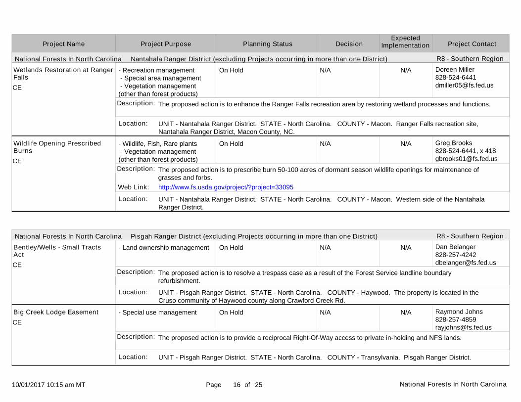
UNIT - Nantahala Ranger District. STATE - North Carolina. COUNTY - Macon. Ranger Falls recreation site, Nantahala Ranger District, Macon County, NC.
UNIT - Nantahala Ranger District. STATE - North Carolina. COUNTY - Macon. Western side of the Nantahala Ranger District.
UNIT - Pisgah Ranger District. STATE - North Carolina. COUNTY - Haywood. The property is located in the Cruso community of Haywood county along Crawford Creek Rd.
UNIT - Pisgah Ranger District. STATE - North Carolina. COUNTY - Transylvania. Pisgah Ranger District.
Location:
Location:
Location:
Location:
N/A
N/A
N/A
N/A
Wetlands Restoration at RangerFalls
Wildlife Opening Prescribed Burns
Bentley/Wells - Small Tracts Act
Big Creek Lodge Easement
The proposed action is to enhance the Ranger Falls recreation area by restoring wetland processes and functions.
The proposed action is to prescribe burn 50-100 acres of dormant season wildlife openings for maintenance of grasses and forbs.
The proposed action is to resolve a trespass case as a result of the Forest Service landline boundary refurbishment.
The proposed action is to provide a reciprocal Right-Of-Way access to private in-holding and NFS lands.
Description:
Description:
Description:
Description:
Web Link: http://www.fs.usda.gov/project/?project=33095
CE
CE
CE
CE
10/01/2017 10:15 am MT Page of17 National Forests In North Carolina 25
National Forests In North Carolina Pisgah Ranger District (excluding Projects occurring in more than one District)
Project PurposeProject Name DecisionPlanning Status Project ContactExpected
Implementation
R8 - Southern Region
- Special use management
- Recreation management
- Wildlife, Fish, Rare plants - Vegetation management (other than forest products)
- Special use management
In Progress:Scoping Start 01/01/2011
Completed
Completed
In Progress:Scoping Start 06/28/2017
Expected:11/2017
Actual: 08/19/2017
Actual: 09/14/2017
Expected:11/2017
Karen [email protected]
David [email protected]
Jason [email protected]
Linda [email protected]
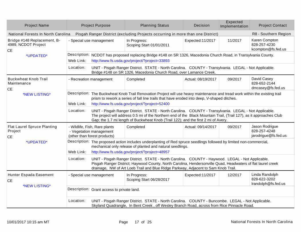
UNIT - Pisgah Ranger District. STATE - North Carolina. COUNTY - Transylvania. LEGAL - Not Applicable. Bridge #148 on SR 1326, Macedonia Church Road, over Lamance Creek.
UNIT - Pisgah Ranger District. STATE - North Carolina. COUNTY - Transylvania. LEGAL - Not Applicable. The project will address 0.5 mi of the Northern end of the Black Mountain Trail, (Trail 127), as it approaches Club Gap; the 1.7 mi length of Buckwheat Knob (Trail 122); and the first 2 mi of Avery.
UNIT - Pisgah Ranger District. STATE - North Carolina. COUNTY - Haywood. LEGAL - Not Applicable. Pisgah Ranger District; Haywood County, North Carolina, Hendersonville Quad, Headwaters of flat laurel creek drainage, NW of Art Loeb Trail and Blue Ridge Parkway, Adjacent to Sam Knob Trail.
UNIT - Pisgah Ranger District. STATE - North Carolina. COUNTY - Buncombe. LEGAL - Not Applicable. Skyland Quadrangle, In Bent Creek , off Wesley Branch Road, across from Rice Pinnacle Road.
Location:
Location:
Location:
Location:
11/2017
09/2017
09/2017
12/2017
Bridge #148 Replacement, B-4989, NCDOT Project
Buckwheat Knob Trail Maintenance
Flat Laurel Spruce Planting Project
Hunter Espada Easement
NCDOT has proposed replacing Bridge #148 on SR 1326, Macedonia Church Road, in Transylvania County.
The Buckwheat Knob Trail Renovation Project will use heavy maintenance and tread work within the existing trail prism to rework a series of fall line trails that have eroded into deep, V-shaped ditches.
The proposed action includes underplanting of Red spruce seedlings followed by limited non-commercial, mechanical only release of planted and natural seedlings.
Grant access to private land.
Description:
Description:
Description:
Description:
Web Link:
Web Link:
Web Link:
http://www.fs.usda.gov/project/?project=33893
http://www.fs.usda.gov/project/?project=52400
http://www.fs.usda.gov/project/?project=48957
*UPDATED*
*NEW LISTING*
*UPDATED*
*NEW LISTING*
CE
CE
CE
CE

10/01/2017 10:15 am MT Page of18 National Forests In North Carolina 25
National Forests In North Carolina Pisgah Ranger District (excluding Projects occurring in more than one District)
Project PurposeProject Name DecisionPlanning Status Project ContactExpected
Implementation
R8 - Southern Region
- Recreation management
- Recreation management
- Special use management
- Special use management
On Hold
On Hold
In Progress:NOI in Federal Register 01/14/2005Est. DEIS NOA in Federal Register 03/2018
On Hold
N/A
N/A
Expected:10/2018
N/A
Patrick [email protected]
Patrick [email protected]
Karen [email protected]
Linda [email protected]
UNIT - Pisgah Ranger District. STATE - North Carolina. COUNTY - Transylvania, Henderson. LEGAL - Not Applicable. North of FSR 1206 (Yellow Gap Road).
UNIT - Pisgah Ranger District. STATE - North Carolina. COUNTY - Haywood. Pisgah RD.
UNIT - Pisgah Ranger District. STATE - North Carolina. COUNTY - Transylvania. LEGAL - Not Applicable. NC 215 from US 64 to SR 1326 south of Balsam.
UNIT - Pisgah Ranger District. STATE - North Carolina. COUNTY - Transylvania. LEGAL - Not Applicable. Intersection of Hwy 276 and Hwy 475A.
Location:
Location:
Location:
Location:
N/A
N/A
11/2018
N/A
Laurel Mountain to Big Creek Connector Trail Construction
Little East Fork Trail Reroute
NC 215, NCDOT Project
Renewal of City of Brevard
The proposed action is to construct new trail to connect two longer trails and create a loop opportunity.
The proposed action is to reroute about 75 yards of existing trail to bypass washout caused by September 2004 tropical storms.
NCDOT has proposed making improvements to NC 215 in Transylvania County from US 64 to SR 1326 south of Balsam.
The proposed action is to renew a special use permit for the City of Brevard.
Description:
Description:
Description:
Description:
Web Link:
Web Link:
Web Link:
http://www.fs.usda.gov/project/?project=48942
http://www.fs.usda.gov/project/?project=20253
http://www.fs.usda.gov/project/?project=46678
*UPDATED*
*UPDATED*
CE
CE
EIS
CE

10/01/2017 10:15 am MT Page of19 National Forests In North Carolina 25
National Forests In North Carolina Pisgah Ranger District (excluding Projects occurring in more than one District)
National Forests In North Carolina Tusquittee Ranger District (excluding Projects occurring in more than one District)
Project PurposeProject Name DecisionPlanning Status Project ContactExpected
Implementation
R8 - Southern Region
R8 - Southern Region
- Special use management
- Special use management
- Wildlife, Fish, Rare plants - Forest products - Vegetation management (other than forest products) - Watershed management
On Hold
On Hold
Developing ProposalEst. Scoping Start 11/2017
N/A
N/A
Expected:05/2018
Linda [email protected]
Karen [email protected]
Steverson [email protected]
UNIT - Pisgah Ranger District. STATE - North Carolina. COUNTY - Transylvania. LEGAL - Not Applicable. FSR 5074.
UNIT - Tusquittee Ranger District. STATE - North Carolina. COUNTY - Cherokee. LEGAL - Not Applicable. Bear Paw Church Road, SR 1313.
UNIT - Tusquittee Ranger District. STATE - North Carolina. COUNTY - Clay. LEGAL - Not Applicable. Southeastern Clay County, North Carolina.
Location:
Location:
Location:
N/A
N/A
07/2018
Toppenberg Easement
Bear Paw Church Road, SR 1313, NCDOT Project
Buck Project
The proposed action is to provide access to private land
NCDOT has requested a 50-foot right-of-way and to make improvements to Bear Paw Church Road, SR 1313. Proposed improvements include very minor changes in centerline and widening.
The proposed action is to conduct silvicultural treatments to implement land and resource management plans for the Nantahala and Pisgah National Forests in southeastern Clay County, North Carolina.
Description:
Description:
Description:
Web Link:
Web Link:
Web Link:
http://www.fs.usda.gov/project/?project=48811
http://www.fs.usda.gov/project/?project=13385
http://www.fs.usda.gov/project/?project=50345
*UPDATED*CE
CE
EA

10/01/2017 10:15 am MT Page of20 National Forests In North Carolina 25
National Forests In North Carolina Tusquittee Ranger District (excluding Projects occurring in more than one District)
Project PurposeProject Name DecisionPlanning Status Project ContactExpected
Implementation
R8 - Southern Region
- Recreation management - Watershed management - Road management
- Special use management
- Special use management
On Hold
On Hold
In Progress:Scoping Start 10/01/2010
N/A
N/A
Expected:02/2018
Steverson Moffat828 837-5152 [email protected]
Julie [email protected]
Karen [email protected]
UNIT - Tusquittee Ranger District. STATE - North Carolina. COUNTY - Clay. LEGAL - Not Applicable. Fires Creek Road (FSR 340) in Clay County, North Carolina.
UNIT - Tusquittee Ranger District. STATE - North Carolina. COUNTY - Cherokee. LEGAL - Cherokee County. Hibbert Branch Road.
UNIT - Tusquittee Ranger District. STATE - North Carolina. COUNTY - Cherokee. LEGAL - Not Applicable. Joe Brown Road, SR 1326C.
Location:
Location:
Location:
N/A
N/A
03/2018
Fires Creek Road Roadslide Repair Project
Hibbert Branch Road Easement
Joe Brown Road, SR 1326C, NCDOT Project
The proposed action is to repair a small road slide on the Fires Creek Road (FSR 340) in Clay County, North Carolina.
The proposed action is to provide a 4200 foot road easement fon Hibbert Branch Road (FS # 650) for a private property owner to gain access to property.
NCDOT has requested a 50-foot right-of-way and to make improvements to Joe Brown Road. Proposed improvements include very minor changes in centerline and widening, grading, drainage improvement, and paving.
Description:
Description:
Description:
Web Link:
Web Link:
http://www.fs.usda.gov/project/?project=47890
http://www.fs.usda.gov/project/?project=33892
*UPDATED*
CE
CE
CE

10/01/2017 10:15 am MT Page of21 National Forests In North Carolina 25
National Forests In North Carolina Tusquittee Ranger District (excluding Projects occurring in more than one District)
Project PurposeProject Name DecisionPlanning Status Project ContactExpected
Implementation
R8 - Southern Region
- Wildlife, Fish, Rare plants - Forest products - Vegetation management (other than forest products) - Watershed management
- Wildlife, Fish, Rare plants - Vegetation management (other than forest products) - Fuels management
- Wildlife, Fish, Rare plants - Forest products - Vegetation management (other than forest products) - Fuels management - Watershed management
Completed
In Progress:Scoping Start 08/28/2017
In Progress:Scoping Start 08/28/2017Est. Comment Period Public Notice 10/2017
Actual: 07/17/2017
Expected:10/2017
Expected:02/2018
Steverson [email protected]
Steverson [email protected]
Steverson [email protected]
UNIT - Tusquittee Ranger District. STATE - North Carolina. COUNTY - Cherokee. LEGAL - Not Applicable. Select stands in western Cherokee County, North Carolina, south of Joe Brown Highway and north of Apalachia Lake.
UNIT - Tusquittee Ranger District. STATE - North Carolina. COUNTY - Cherokee. LEGAL - Not Applicable. Panther Top area of Cherokee County, NC.
UNIT - Tusquittee Ranger District. STATE - North Carolina. COUNTY - Cherokee. LEGAL - Not Applicable. National Forest System lands near the Prospect Community and Hamby Bend areas of Cherokee County, NC.
Location:
Location:
Location:
08/2017
01/2018
03/2018
Long Buck Project
Panther Top Prescribed Burn Additions
Prospect-Hamby Project
The proposed action is to conduct silvicultural treatments to reestablish shortleaf pine / mixed hardwood vegetationcommunities on select stands in western Cherokee County, North Carolina, north of Apalachia Lake.
Add three new areas totaling approximately 1,440 acres to the prescribed burning program adjacent to existing burn units in the Panther Top area in Cherokee County, North Carolina.
The proposed action is to conduct multi-resource management treatments on National Forest System lands on theTusquitee Ranger District in western Cherokee County, NC.
Description:
Description:
Description:
Web Link: http://www.fs.usda.gov/project/?project=50344
*UPDATED*
*NEW LISTING*
*UPDATED*
EA
CE
EA

10/01/2017 10:15 am MT Page of22 National Forests In North Carolina 25
National Forests In North Carolina Tusquittee Ranger District (excluding Projects occurring in more than one District)
National Forests In North Carolina Uwharrie Ranger District (excluding Projects occurring in more than one District)
Project PurposeProject Name DecisionPlanning Status Project ContactExpected
Implementation
R8 - Southern Region
R8 - Southern Region
- Wildlife, Fish, Rare plants
- Recreation management
- Recreation management
On Hold
In Progress:Scoping Start 08/19/2016
In Progress:Scoping Start 08/19/2016Est. Comment Period Public Notice 05/2017
N/A
Expected:11/2017
Expected:09/2017
Doreen [email protected]
Theresa Savery910-576-6391 x [email protected]
Theresa Savery910-576-6391 x [email protected]
UNIT - Tusquittee Ranger District. STATE - North Carolina. COUNTY - Cherokee. Walker Fields, Tusquitee Ranger District, Cherokee County, NC.
UNIT - Uwharrie Ranger District. STATE - North Carolina. COUNTY - Montgomery. LEGAL - Not Applicable. Badin Lake Recreation Area, 15 miles northwest of Troy, NC.
UNIT - Uwharrie Ranger District. STATE - North Carolina. COUNTY - Montgomery. LEGAL - Not Applicable. Within the Badin Lake Recreation Area, 15 miles northwest of Troy, NC.
Location:
Location:
Location:
N/A
12/2017
09/2017
Walker Fields Wildlife
Dickey Bell OHV Trail Re-route
Hang Glider Equestrian Trail closure
The proposed action is to remove encroaching woody vegetation from wildlife food plots at Walker Fields.
The proposed action is to re-route 1.0 mile of off-highway vehicle trail of the Dickey Bell trail and close 0.5 mile of existing trial in a sensitive resource area.
The proposed action is to close and rehabilitate 0.4 mile of equestrian trail due to sensitive resource concerns.
Description:
Description:
Description:
Web Link:
Web Link:
http://www.fs.usda.gov/project/?project=50079
http://www.fs.usda.gov/project/?project=50084
CE
CE
EA

10/01/2017 10:15 am MT Page of23 National Forests In North Carolina 25
National Forests In North Carolina Uwharrie Ranger District (excluding Projects occurring in more than one District)
Project PurposeProject Name DecisionPlanning Status Project ContactExpected
Implementation
R8 - Southern Region
- Recreation management
- Recreation management
- Special use management
In Progress:Scoping Start 08/19/2016Est. Comment Period Public Notice 05/2017
In Progress:Scoping Start 08/19/2016
In Progress:Scoping Start 07/10/2006Est. 215 Comment Period LegalNotice 12/2017
Expected:08/2017
Expected:04/2017
Expected:12/2017
Theresa Savery910-576-6391 x [email protected]
Theresa Savery910-576-6391 x [email protected]
Karen [email protected]
UNIT - Uwharrie Ranger District. STATE - North Carolina. COUNTY - Montgomery. LEGAL - Not Applicable. Trail is within the Badin Lake Recreation Area, 15 miles northwest of Troy, NC. Section of trail is between Slab PileOHV trail and Sawmill OHV trail.
UNIT - Uwharrie Ranger District. STATE - North Carolina. COUNTY - Montgomery. LEGAL - Not Applicable. Within the Badin Lake Recreation Area, 15 miles northwest of Troy, NC.
UNIT - Uwharrie Ranger District. STATE - North Carolina. COUNTY - Montgomery. LEGAL - Not Applicable. NC 24/27 from the Troy Bypass to NC 73.
Location:
Location:
Location:
09/2017
05/2017
03/2019
Kodak Rock OHV Trail closure
Morgan Equestrian Trail Re-route
NC 24/27 Widening Project, NCDOT Project
The proposed action is to close a section of the Rocky Mountain Loop Off-highway vehicle (OHV) trail in the area known as Kodak Rock, for 0.85 miles and stabilize a portion of that trail section to prevent erosion.
The proposed action is to re-route 0.4 mile of equestrian trail and close 0.4 mile of trail within a sensitive resource area.
NC DOT has proposed widening from two lanes to four lanes of NC 24/27 from NC 73 to the Troy Bypass. Approximately 2.7 miles of this 11 mile project are located on Forest Service lands.
Description:
Description:
Description:
Web Link:
Web Link:
Web Link:
http://www.fs.usda.gov/project/?project=50080
http://www.fs.usda.gov/project/?project=50083
http://www.fs.usda.gov/project/?project=15715
EA
CE
EA

10/01/2017 10:15 am MT Page of24 National Forests In North Carolina 25
National Forests In North Carolina Uwharrie Ranger District (excluding Projects occurring in more than one District)
Project PurposeProject Name DecisionPlanning Status Project ContactExpected
Implementation
R8 - Southern Region
- Special use management
- Special use management
- Wildlife, Fish, Rare plants - Vegetation management (other than forest products)
- Land management planning
In Progress:Scoping Start 03/10/2015
In Progress:Scoping Start 09/20/2016
On Hold
Completed
Expected:10/2016
Expected:09/2018
N/A
Actual: 05/26/2017
Donald [email protected]
Michael [email protected]
Gary [email protected]
Michelle [email protected]
UNIT - Uwharrie Ranger District. STATE - North Carolina. COUNTY - Montgomery. LEGAL - Not Applicable. access road off SR 1150 (River Rd).
UNIT - Uwharrie Ranger District. STATE - North Carolina. COUNTY - Montgomery. LEGAL - Not Applicable. Tower Road (SR 1134).
UNIT - Uwharrie Ranger District. STATE - North Carolina. COUNTY - Randolph, Davidson, Macon. Montgomery, Randolph, and Davidson Counties.
UNIT - Uwharrie Ranger District. STATE - North Carolina. COUNTY - Montgomery, Randolph, Davidson. LEGAL - Not Applicable. Uwharrie National Forest.
Location:
Location:
Location:
Location:
11/2016
10/2018
N/A
06/2017
Newport road easement new permit UWH121301
REMC Pole Replacement TowerRoad
Uwharrie District Non-native Invasive Plant Treatment
Uwharrie NF Monitoring Program
The proposed action is to issue a road easement to a private land owner to access a recreation cabin using a utilityright-of-way. This permit requires minor road construction and reconstruction.
The proposed action is to install a new power pole and lines to replace existing lines, in a new location.
The proposed action is to treat non-native invasive plants on the Uwharrie National Forest using a combination of mechanical, cultural, and chemical treatments.
Update to the Uwharrie NF Monitoring Plan
Description:
Description:
Description:
Description:
Web Link:
Web Link:
Web Link:
http://www.fs.usda.gov/project/?project=46450
http://www.fs.usda.gov/project/?project=34643
http://www.fs.usda.gov/project/?project=48941
*UPDATED*
*UPDATED*
CE
CE
EA
CE

10/01/2017 10:15 am MT Page of25 National Forests In North Carolina 25
National Forests In North Carolina Uwharrie Ranger District (excluding Projects occurring in more than one District)
The U.S. Department of Agriculture (USDA) prohibits discrimination in all its programs and activities on the basis of race, color, national origin, age, disability, and where applicable, sex, marital status, familial status, parental status, religion, sexual orientation, genetic information, political beliefs, reprisal, or because all or part of an individual's income is derived from any public assistance program. (Not all prohibited bases apply to all programs.) Persons with disabilities who require alternative means for communication of program information (Braille, large print, audiotape, etc.) should contact USDA's TARGET Center at (202) 720-2600 (voice and TDD).
To file a complaint of discrimination, write USDA, Director, Office of Civil Rights, 1400 Independence Avenue, SW, Washington, DC 20250-9410 or call (800) 795-3272 (voice) or (202) 720-6382 (TDD). USDA is an equal opportunity provider and employer.
This report contains the best available information at the time of publication. Questions may be directed to the Project Contact.
Project PurposeProject Name DecisionPlanning Status Project ContactExpected
Implementation
R8 - Southern Region
- Recreation management In Progress:Scoping Start 03/29/2017
Expected:10/2017 Theresa Savery910-576-6391 x [email protected]
UNIT - Uwharrie Ranger District. STATE - North Carolina. COUNTY - Montgomery, Randolph. LEGAL - Not Applicable. This project is 15 miles north of Troy, NC between Jumpin' Off Rock Trailhead on Flint Hill Rd (SR1306) & Forest Service lands just south of High Pine Church RD (SR1143). This goes north from SR1306.
Location:
10/2017Uwharrie National Recreation Trail Reroute
The proposed action is to reroute 2.1 miles of the Uwharrie NR Trail & add it and 5.6 existing miles of trail to the UNRT system. Add the Joe Moffit Trailhead & Little Long Mountain Shelter to the Uwharrie NF & add 0.5 miles of trail as Luther Spur.
Description:
Web Link: http://www.fs.usda.gov/project/?project=51501
CE