satori: situation assessment through the re-creation of ... · creation of incidents (satori)....
TRANSCRIPT

AD-A268 390
DOT/FAA/AM-93,iz SATORI: Situation
Office of Aviation Medicine Assessment through theWashington, D.C. 20591 Re-creation of Incidents
Mark D. Rodgers
Civil Aeromedical Institute
Federal Aviation Administration
Oklahoma City, Oklahoma 73125
Duane A. Duke
Office of Information Services
Federal Aviation Administration
Oklahoma City, Oklahoma 73125
July 1993 DTICurný' U
-- AUG2 4 1993U
Final Report A 2
____This document is available to the public
___ •through the National Technical Information
Service, Springfield, Virginia 22161.
=00
U.S. Departmentof TransportationFederal AviationAdministration
93 8 23 087

NOTICE
This document is disseminated under the sponsorship ofthe U.S. Department of Transportation in the interest of
information exchange. The United States Governmentassumes no liability for the contents or use thereof.
Technical Report Documentation Page
1. Report No. 2. Government Accession No. 3. Recipient's Catalog No.
DOTIFAAIAM-93112
4. Title and Subtitle 5. Report Date
SATORI: Situation Assessment through the Re-creation July 1993of Incidents 6. Performing Organization Code
7. Author(s) 8. Performing Organization Report No.
Mark D. Rodgers, Ph.D., and Duane A. Duke
9. Performing Organization Name and Address 10. Work Unit No. (TRAIS)
FAA Civil Aeromedical InstituteP.O. Box 25082Oklahoma City, OK 73125 11. ContractorGrant No.
12 Sponsoring Agency name and Address 13. Type of Report and Period Covered
Office of Aviation MedicineFederal Aviation Administration800 Independence Avenue, S.W.Washington, DC 20591 14. Sponsorng Agency Code
15. Supplemental Notes
16. Abstract
A system has been developed that graphically re-creates the radar data recorded at En Route air traffic control(ATC) facilities. Each facility records data sent to the displays associated with the airspace under its control on aSystem Analysis Report (SAR) tape. SATORI (Situation Assessment Through Re-creation of Incidents) overlaysthe SAR data on the appropriate sector maps using map data from the Adaptation Control Environmental System(ACES) database. The analog switch display settings of the plan view display (PVD) are not recorded; however,subroutines have been written for SATORI that allow the display to be set up with the settings reported to have beenused by a given controller. In addition, SATORI has the capability to display the high and low weather intensitythat was displayed on a given PVD. All software routines written for SATORI use Open Systems Foundation (OSF)technology. Similar data to those available from En Route facilities are recorded at Terminal Radar ApproachControl (TRACON) facilities and should allow for the development of a re-creation tool much like the onediscussed in this report. Once SATORI is developed and evaluated, it will be possible to accomplish the goals ofevaluating system designs, over-the-shoulder appraisals, training outcomes, procedures, airspace design, andmeasuring controller performance. Not only will the capabilities and features of SATORI provide those interestedin air traffic with a valuable tool for assessing the dynamics of the air traffic situation, but additionally, and moreimportantly, the Agency will be in a better position to bring about effective change in future ATC systems.
17 Key Words 18. Distribution Statement
Air Traffic Control Human Factors Document is available to the public through theHuman Performance Training National Technical Information Service,Operational/Systems Errors Springfield, Virginia 22161.
19. Security Clasaif. (of this report) 20. Security Classif. (of this page) 21. No. of Pages 22. Price
Unclassified Unclassified 14
Form DOT F 1700.7 (8-72) Reproduction of completed page authorized
ACKNOWLEDGMENTS
The authors gratefully acknowledge Stanley D. Endsley, Jr. (Air Traffic Manager), Alton F. Guice (Quality
Assurance Air Traffic Control Specialist), and the Quality Assurance and Automation staff at the Atlanta Air
Route Traffic Control Center for patiently assisting the authors throughout the SATORI development
process. Special thanks to John D. Canoles (Director of the Office ofAir Traffic Systems Effectiveness), James
K. Buckles (Manager of the Quality Assurance Division), Samuel F. Woods (Manager of the Investigations
Branch), and the staff ofthe Investigations BManch for their assistance in providing coordination throughout
the project. Thanks also to Gregory L. Hill (Manager of the Host/En Route Operations Section), Weldon R.
Reichel (Systems Software Specialist) and Cynthia M. Fox (Psychology Technician) for their assistance in data
editing and the development of user documentation. We also wish to acknowledge Dennis R. Rester
(Computer Specialist) for his development of the audio portion of SATORI.
DTIC QUALITy 71SPECTED 3
Iooe.sion For
NTIS GRA&IDTIC TABUnanno:•nced EJustification
By_Distrl butlocn/i
I Avalabtlity Codes
Avail and/orDist Soost seial

SATORI: SITUATION ASSESSMENT THROUGHRE-CREATION OF INCIDENTS
INTRODUCTONA system has been developed that graphically re- Specialists (ATCSs) at En Route fcilities are re-creates the radar data recorded at En Route air traffic quired to maintain either 2,000 feet vertical separa-control (ATC) facilities. These data are sent to the tion or 5 miles horizontal separation between aircraft.controller scope, called the Plan View Display (PVD), At flight levels below 29,000 feet with aircraft underand the Continuous Readout Update Display (CRD). IFR conditions, ATCSs are required to maintainThe re-creation synchronizes the graphic display of either 1,000 feet vertical separation or 5 miles hori-these data with tapes containing the associated verbal zontal separation. An operational error (OE) takesinteractions between pilots and the controller. This place when an ATCS allows less than the prescribedsystem is called Situation Assessment Through Re- minimum separation distances between aircraft (orcreation of Incidents (SATORI). SATORI is a an aircraft and an obstruction).Japanese word that translates to English as "insight."In Zen Buddhism, it refers to a "state of Analysis of Operational Errorsenlightenment." It is hoped that, through the use of Currently, the FAA Office of Air Traffic Systemsthe SATORI system, it will be possible to gain a Effectiveness requires an investigation into each OE.better understanding of the interaction between the This investigation involves determining thevarious elements of displayed information, verbal circumstances in which the OE occurred and theinteractions, and the control actions taken by air causal factors associated with the error. Initially, atraffic control specialists (ATCSs). preliminary investigation report (FAA 7210-2) is
filed in which possible causal factors are identifiedDescription of ATC System and a final report (FAA 7210-3) filed shortly thereafter.This development uses data obtained from Air Route A project related to the development of'SATORI andTraffic Control Centers (ARTCCs), also called En sponsored by the FAA Office of Air Traffic SystemsRoute facilities. ATCSs at those facilities primarily Effectiveness involves studying the tasks of an Enhandle aircraft traveling between the terminal facilities Route ATCS associated with the commission of anacross the nation. Each facility records PVD and OE. One way to analyze OEs would be to identifyCRD data associated with the airspace under its which tasks were omitted or were performedcontrol on a System Analysis Report (SAR) tape. The incorrectly. This may facilitate identification ofSAR tape contains all of the recorded dynamic display training needs or system deficiencies. In order for theinformation about the National Airspace System tasks associated with the commission of an OE to be(NAS), including weather, and the aircraft traversing identified, it must become possible for one to reviewit. Verbal interactions between pilots and controllers the dynamics of the situation in which the irregularityare recorded on a multi-channel tape unit at each occurred.facility.
Prior to the development of SATORI, it was notATCSs are required to maintain certain separation possible for the Quality Assurance (QA) team inves-
minima between aircraft under their control. Stan- tigating errors to review how the control situationdards for separation minima are described in the Air was seen by the ATCS as the OE occurred. That is,Traffic Control (ATC) Handbook (7110.65G, and the dynamics (the interaction between control ac-supplemental instructions). While there is consider- tions and displayed data) of the situation were un-able complexity in those standards, at flight levels available for review, not only by the QA teambetween 29,000 and 45,000 feet, Air Traffic Control investigating the irregularity, but also by the control-

ler who committed the error. This limited not only brief note is included for issues yet to be resolvedthe extent to which a determination could be made of concerningcapabilities under development. A detailedthe tasks involved in an error, but also the effects of discussion of the National Airspace System Programthe dynamic situation on ATCS situation awareness. (NASP) data files required for the development is
provided when relevant. Also included in this sectionIn addition, the only means by which a graphical is a discussion ofthe required hardware developments
representation of an En Route OE could be achieved and graphics software requirements for SATORI.was to obtain a printout of the National Track The second section discusses the potential applicationsAnalysis Program (NTAP) or to have a simulation ofSATORI. Aconcludingsection discusses the futurebuilt at the ARTCC or FAA Technical Center using developments andpotentialdirectionsofthe SATORIdynamic simulation (DYSIM) equipment. NTAP project.processes NAS data recorded on the SAR tape andprovides a plot ofaircraft tracks and altitude informa- Graphical Re-creation of Airspacetion as output using a line printer. NTAP is limited For the SATORI development, the SAR tape isto the display of about four aircraft, however some of edited using the Data Analysis and Reduction Toolthe data are lost when all four aircraft are displayed System (DART) and NTAP to obtain only those filessince it was designed not to overwrite information required to provide the information displayed on thealready printed. When only two aircraft are dis- PVD and CRD. Several data files are required toplayed, the information loss due to printing is mini- obtain the necessary information for re-creating themal. The DYSIM simulation built at the FAA information presentedonthePVD.AircraftpositionTechnical Center or ARTCC is nat as timely or information is recorded in three separate files, one foraccurate as NTAP. Each piece of data and its associ- each of the three symbols that could potentially beated track must be hand entered to build a simulation presented on the PVD for any given aircraft. Theseusing DYSIM equipment. The simulation would three symbols are the aircraft position symbol, beacononly be as accurate as the data used to create it, and target, and primary target.since this is an extremely labor intensive process,typically not all of the data points are used. The tracks of the aircraft position symbols as they
move through the facility airspace are recorded on theWithout the ability to review an error with the SAR tape for aircraft under positive control and are
involved controller, the dynamics between the situa- available using DART; the file is called TRACK.tion and control actions taken, as well as the task Position symbols are updated every 6 seconds andelements involved in the OE, remain relatively ob- represent predicted aircraft positions based on thescure. The purpose of SATORI is to display the ATC current aircraft track. This file also specifies thesituation dynamics so that a more definitive determi- information contained in the data block and thenation of the factors involved in OEs becomes pos- direction of its leader line. DART does not allow forsible. SATORI utilizes a multi-media graphics the extraction of aircraft primary radar or beaconworkstation, which has the capability of developing targets, which are also recorded on the SAR tape.a library of OEs and an OE performance and taskload These data files are extracted using NTAP. Primarydatabase. A diagram of the SATORI data processing targets represent the position of aircraft based onflow is provided in Figure 1. radar data. Primary targets are required for the dis-
play of aircraft not under positive control (i.e.,SATORI DEVELOPMENT uncorrelated targets) in the sector being re-created.
Primary targets are updated on the PVD every 10, 11,The following is a discussion of the SATORI or 12 seconds depending on the aircraft locationdevelopment process. First, currentsystem capabilities relative to the radar site and represent actual aircraftare described along with those under development. A location to the degree of accuracy associated with the
2

Figure 1. SATORI Data Process Flow Chart
DR M agneto Opt ica03480 Tape
HOSpTe SAR F[ ý J DWie
(mp3480 Tape 3480System stmNTAP TrafTfpeiM am
3480 Tape Drive Multi-MediaGraphics VDTACES Wobrk Station
3480 Ta~pe VAX 4000-90(Map Data)l
Audio IRIG - TICD
Time Code Display Error Analysis3Design ModificationCapacity Timing (Right) Traffic Management
Voice Audio Voice System Training Req. Ident.Recorder Cassette -- Analog - Digital Procedures lDesign
F Voice (Left) VieSse
Digital - Analog
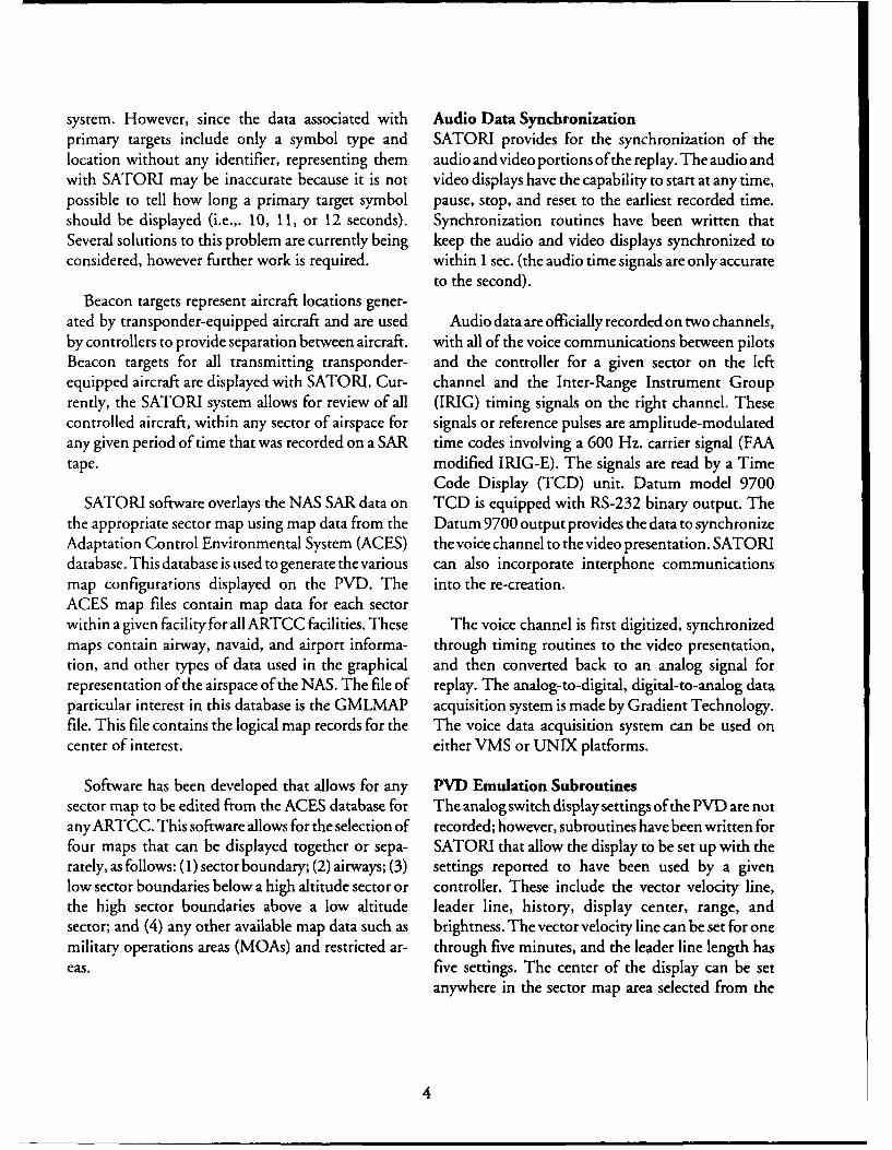
system. However, since the data associated with Audio Data Synchronizationprimary targets include only a symbol type and SATORI provides for the synchronization of thelocation without any identifier, representing them audio and video portions ofthe replay. The audio andwith SATORI may be inaccurate because it is not video displays have the capability to start at any time,possible to tell how long a primary target symbol pause, stop, and reset to the earliest recorded time.should be displayed (i.e.,. 10, 11, or 12 seconds). Synchronization routines have been written thatSeveral solutions to this problem are currently being keep the audio and video displays synchronized toconsidered, however further work is required. within 1 sec. (the audio time signals are only accurate
to the second).
Beacon targets represent aircraft locations gener-ated by transponder-equipped aircraft and are used Audio data are officially recorded on two channels,by controllers to provide separation between aircraft, with all of the voice communications between pilotsBeacon targets for all transmitting transponder- and the controller for a given sector on the leftequipped aircraft are displayed with SATORI. Cur- channel and the Inter-Range Instrument Grouprently, the SATORI system allows for review of all (IRIG) timing signals on the right channel. Thesecontrolled aircraft, within any sector of airspace for signals or reference pulses are amplitude-modulatedany given period of time that was recorded on a SAR time codes involving a 600 Hz. carrier signal (FAAtape. modified IRIG-E). The signals are read by a Time
Code Display (TCD) unit. Datum model 9700SATORI software overlays the NAS SAR data on TCD is equipped with RS-232 binary output. The
the appropriate sector map using map data from the Datum 9700 output provides the data to synchronizeAdaptation Control Environmental System (ACES) the voice channel to the video presentation. SATORIdatabase. This database is used to generate the various can also incorporate interphone communicationsmap configurations displayed on the PVD. The into the re-creation.ACES map files contain map data for each sectorwithin a given facility for all ARTCC facilities. These The voice channel is first digitized, synchronizedmaps contain airway, navaid, and airport informa- through timing routines to the video presentation,tion, and other types of data used in the graphical and then converted back to an analog signal forrepresentation of the airspace of the NAS. The file of replay. The analog-to-digital, digital-to-analog dataparticular interest in this database is the GMLMAP acquisition system is made by Gradient Technology.file. This file contains the logical map records for the The voice data acquisition system can be used oncenter of interest. either VMS or UNIX platforms.
Software has been developed that allows for any PVD Emulation Subroutinessector map to be edited from the ACES database for The analog switch display settings of the PVD are notany ARTCC. This software allows for the selection of recorded; however, subroutines have been written forfour maps that can be displayed together or sepa- SATORI that allow the display to be set up with therately, as follows: (1) sector boundary; (2) airways; (3) settings reported to have been used by a givenlow sector boundaries below a high altitude sector or controller. These include the vector velocity line,the high sector boundaries above a low altitude leader line, history, display center, range, andsector; and (4) any other available map data such as brightness. The vector velocity line can be set for onemilitary operations areas (MOAs) and restricted ar- through five minutes, and the leader line length haseas. five settings. The center of the display can be set
anywhere in the sector map area selected from the
4

ACES database. Range is selectable from 6 to 400 Hardware and Software Systemsmiles; however, data are edited from the SAR All software routines written for SATORI use Openaccording to the PVD device number and, therefore, Systems Foundation (OSF) technology. The OSFmight not be available for display at all ranges. standard recommends the use of an operating systemBrightness is adjustable only as a function of the with Posix compliance, ANSI C programmingworkstation's monitor controls. SATORI also allows language, the X-Windows graphics system, an OSF/for the display of the J-rings a controller selected for Motif graphical user interface, and network TCP/IPdisplay. compliance. This permits the system the widest range
of portability to the largest number of platforms. TheDigital settings on the PVD, such as altitude filter platform for this development is a VAXstation 4000-
selections, display ofweather, alpha-numeric keypad 90, conversion to the DEC Alpha workstation is in(ANK) entries, use of quick action keys (QAK), and progress. The 4000-90 workstation has 40MB ofany changes made to the digital settings are recorded RAM and a 1.35 gigabyte hard drive. A rewritableon the SAR tape. Using DART to obtain the LOG magneto-optical CD drive is available for storage offile from the SAR tape, it is possible to identify data, as is the 3480 tape drive used to read SAR,specifically what those settings arid changes were and DART, and ACES tapes sent from field facilities.when they occurred. The SATORI system allows fordisplay of the LOG file data, which are the digitally SATORI APPLICATIONSrecorded Host Computer System (HCS)/ATCS in-teractions. Most of these data are displayed on the Previous to the development of SATORI, it was notCRD display located next to the PVD display. The possible to replaygraphically the movement ofaircraftCRD displays all data entered using the alpha-nu- targets and their associated data blocks across a givenmeric keypad and quickaction keys (QAK). Both the sector of En Route airspace synchronized to theradar and data positions can make QAK and ANK associated voice data. This capability has the potentialentries, which are displayed on separate CRDs. of improving the safety of the NAS. A discussionSATORI displays the CRD data from both positions follows ofthe potential benefits from using SATORI.simultaneously on separate CRD displays. HCS re-sponse to requests for route readouts, and arrival/ Incident Reviewsdeparture iists is nut currently part of this deveiop- Quality Assurance (QA) teams will have a tool forment. reviewing the situational dynamics that occurred
during an incident under review. Currently, QAIn addition to the above, SATORI has the capabil- review of an OE involves looking at the NTAP
ity to display the high and low weather intensity that printout, a process that is limited to the display of twowas displayed on a given PVD. This should be to five airLraft targcts and associated limited dataparticularly helpful in reviewing situations requiring blocks presented on paper. SATORI will provide thepilot deviations from typical routes when navigating capability for the simultaneous display of all aircraftaround weather. Both heavy and light weather sym- targets and data blocks for a given sector of airspacebols are available for review with data obtained using in a video format in sync with the associated voiceNIAP. Conflict alerts for a given sector will be track. NTAP would remain the legal tool used foravailable for display with data obtained using DART. assessment of the loss of separation; however, thisElectronic versions of flight progress strips (FPSs) can system would facilitate investigation in determiningbe created. If the original FPSs are unavailable, it will the situational dynamics that took place prior to andbe possible to view the original FPSs before any strip during an error. It would also provide an opportunitymarkings occurred. to demonstrate "good" techniques of control and
outstanding flight assists.
5

DYSIM Review With the use of SATORI, the job tasks taxonomyIt will be possible to use SATORI to review (Rodgers and Drechsler, 1993), the reference guideperformance on DYSIM problems without the use of to tasks associated with the causal factor categories oftraining time on a PVD. At present there is no the current operational error reporting systemcapability to replay a given controller's or trainee's (Rodgers, 1993), taskload and performance measuresperformance on a DYSIM problem. DYSIM data are (Rodgers and Manning, 1993), and the assistance ofrecorded on the SAR tape and would involve the the controller involved in the error, it should besame process for data reduction as that for actual possible to identify which actions were omitted orATC situation re-creation. It is hoped that through which were done incorrectly to precipitate the error.the review DYSIM performance and OEs and thedetermination of the tasks that were omitted or were Design Appraisaldone incorrectly it will be possible to identify those The FAA has a requirement to evaluate its currenttasks that should be addressed in remedial training. systems against proposed futureATCsystems designs.
Without a means to objectively assess the current
ATCS Performance Measures ATC system ATCS taskload and its effect on ATCSSATORI has the capability to provide a basis for performance, it is not possible to make a meaningfuldeveloping objective measures of controller evaluation of the potential impacts of any designperformance rather than over-the-shoulder changes proposed to be made. With the likely increaseassessments derived from simulated scenarios. A in automation of future ATC systems, it becomesnumber of measures have been developed by imperative that the Agency have the capability toresearchers at CAMI and the FAA Technical Center make comparisons between proposed system designsfor use in evaluating ATCS performance. These and the current system. Without such a tool themeasures and the system being developed for their design process will be speculative and not cost effective.calculation using NAS data are described in detail ina report by Rodgers and Manning (1993). Traffic Management
SATORI will allow for the review of the impact ofIf the performance of several controllers is re- airspace design on the flow of traffic through a
corded for a DYSIM problem, it should be possible facility's airspace. Currently, SATORI is simply anto compare an individual's performance with group animation tool that re-creates the traffic flow throughperformance on the same problem. It would be a sectors airspace. The development of a simulationpossible to review over-the-shoulder assessment tech- routine to evaluate redefined airspace characteristicsniques for accuracy. This would utilize the objective is currently under development. This software wouldmeasures of performance currently under develop- allow for the modification of airspace, airways,ment as mentioned above. These measures would navigation aids, etc., to review their effect on trafficprovide a standard for training ATC instructors or flow. Calculation of measures ofsector characteristicsevaluators in over-the-shoulder rating techniques is also under development.and a means to objectively evaluate their perfor-mance. FUTURE DEVELOPMENTS
OE Research Tool An automatic OE detection system was implementedSATORI will provide a research tool for investigating in domestic ARTCCs in 1984. Under this system, anthe tasks and controller actions involved in the alarm is triggered whenever minimum separationcommission of En Route OEs. Previous to the standards are violated by radar-tracked aircraft.development of SATORI, there was no means by Although this system allowed for violations ofwhich the dynamics of the control situation could be separation standards to be more closely monitored, itunderstood because they were unavailable for review. did little to assist in determining why or how such
6

violations occurrý,4 It is planned that SATORI will REFERENCESprovidea me,"- 1Or determining the particular systemcomponent that failed. The identification of tasks Endsley, M. R, (1992). Situation Awareness.Affundamentalthat consistently cause problems for controllers would factor underlying the successful implementation ofAl inbe candidates deserving consideration for automation the air traffic controlsystem. NASA/FAA Workshop onor the development of automated aids. Instead of Artificial Intelligence and Human Factors in Air Traf-attempting to automate all tasks, it would be better to fic Control and Aviation Maintenance. Daytona Beach,automate only those that have the potential to give FL, June.controllers problems. Research has demonstratedthat humans are not well suited for passive monitoring Federal Aviation Administration. (1991). Air Traffic Controlof system performance. Performance typically (FAA Order 7110.65G). Washington, DC: U.S. De-improves when they are actively involved in the partment of Transportation.control of the situation. The optimal level ofautomation in air traffic control isyet to be determined, Rodgers, M. D. & Manning, C. A. (1993). Performance andand the potential for over-automation should not be taskload measurement of En Route air traffic controldiscounted (Endsley, 1992). The effect of automation specialist (in preparation).Washington, DC: Federalon ATCS situational awareness deserves greater Aviation Administration, Office of Aviation Medi-attention. cine.
Additionally, a development is underway to at- Rodgers, M. D. (1993). Relationship between En Route airtempt to utilize Continuous Data Recording (CDR) traffic controlspecialistjob tasks and causalfactor catego-data from the TRACON environment to provide a ties of the current operational error reporting system: ASATORI tool for those facilities. Similar data to Reference Guide (in preparation). Washington, DC:those available from En Route facilities are recorded Federal Aviation Administration, Office of Aviationat TRACON facilities and should allow for the Medicine.development of a re-creation tool much like the onediscussed in this report. Rodgers, M. D. & Drechsler, G. K., (1993). Conversion of
the CTA Incorporated job tasks database into a formalThe development of software to allow for the sentence outline. DOT/FAA/AM 93/1. Washington,
assessment of performance and taskloading is cur- DC: Federal Aviation Administration, Office ofAvia-rently underway. Most of the required algorithms for tion Medicine.the various measures have been derived and arecurrently being converted to source code. This devel-opment will be discussed in detail in a report inpreparation (Rodgers and Manning, 1993).
Once SATORI is developed and evaluated, it willbe possible to accomplish the goals of evaluatingsystem designs, over-the-shoulder appraisals, train-ing outcomes, and measuring controller performance.Not only will the capabilities and features ofSATORIprovide those interested in air traffic with a valuabletool for assessing the dynamics of the air trafficsituation, but additionally, and more importantly,the Agency will be in a better position to bring abouteffective change in future ATC systems.
7

APPENDIX A. SATORI GLOSSARY
ACES (Adaptation Control Environmental System) - A CDR (Continuous Data Recording) - A service withindatabase used to generate the various map configurations NAS that provides a means of data transfer from memorydisplayed on the PVD. to magnetic tape in which recordings are initiated by
specific requests placed within the ATC subprograms.AIRWAY - A control area or portion thereof established This program is available at TRACON facilities to collectin the form of a corridor, the centerline of which is andanalyzeairtrafficstatisticsandmaintenancestatistics,
defined by radio navigational aids. and to produce detailed ATC operational information foruse in proceedings and investigations.
ALGORITHM - A set of instructions that solve amathematical problem. CRD (Continuous Readout Update Display) -A cathode
ray tube (CRT) measuring approximately five inches
ALTITUDE FILTER KEYS - Eight display filter keys, wide by eight inches high used by air traffic controllers.which cause a target symbol to be displayed for all Mode The functions of the CRD are to communicate computer-
C aircraft within the selected area. updated data to the sector; to output error, rejection, andacceptance messages; and to display data in response to
ANSI C - A version of the C prigramming language that controller request.was standardized by an American National StandardsInstitute (ANSI) committee to eliminate variations that DART (Data Analysis and Reduction Tool) - A tool thatcould cause problems in transporting a program from one reduces SAR tapes, generates reports, analyzes datatype of computer system or environment to another. reduced, and compares data with the data previously
reduced. DART contains a general print program with aARTCC (Air Route Traffic Control Center) - A facility number of output operations available that are exercisedestablished to provide air traffic control service to aircraft by a programmer coded table. This table controls the useoperating on IFR flight plans within controlled airspace of the operations and the conversion of the compressedand principally during the en route phase of flight, data on the tape to the normal printed format.
ATC (Air Traffic Control) - A service operated by DATA BLOCKS - Letters and numerals used to showappropriate authority to promote the safe, orderly and identification, altitude, beacon code, and otherexpeditious flow of air traffic. information concerning a target on a radar display.
ATCS (Air Traffic Control Specialist) - A person DYSIM (Dynamic Simulation) - A piece of equipmentauthorized by the FAA to provide air traffic control developed by the FAA Technical Center in which aservice, simulation of an En Route operational error can be built
by hand entry of each piece of data and its associatedBEACON TARGET - A computer-generated indication track.shown on a radar display resulting from a radar beaconreply. FAA (Federal Aviation Administration) - A component
-f the Department of Transportation responsible for airCAMI (Civil Aeromedical Institute) - The aeromedical navigation and air traffic control; certification, regulationresearch, education, certification, and occupational health and compliance of aircraft and people working in thewing of FAA's Office ofAviation Medicine located at the aviation field; aviation security; and aviation-relatedMike Monroney Aeronautical Center in Oklahoma City, research and development programs.Oklahoma.
A-1
FAA TECHNICAL CENTER - An aviation laboratory MOA (MilitaryOperationsArea) -An airspace assignmentlocated in Atlantic City, New Jersey, where test and of defined vertical and lateral dimensions establishedevaluation activities are conducted in support of FAA outside positive control areas toseparate/segregatecertainresearch and development programs. military activities from IFR traffic and to identify for VFR
traffic where these activities are conducted.FLIGHT PROGRESS STRIPS - used to post currentdata on air traffic and clearances required for control and MOTIF - A graphical user interface that was designed toother air traffic control services, work identically on a wide variety of platforms. MOTIF
is the recommended graphical user interface for OSF.GIGABYTE -One billion bytes, or units of informationconsisting of a single character. NAS (National Airspace System) -The common network
of U.S. airspace; air navigation facilities, equipment andGMLMAP - ACES file that contains the logical map services, airports of landing areas; aeronautical charts,records of data required to build sector maps. information and services; rules, regulations and
procedures, technical information, and manpower andHOST COMPUTER SYSTEM - A computer system material. Included are system components shared jointlythat utilizes IBM computer equipment at all ARTCCs in with the military.the continental United States for flight data posting.
NASP (National Airspace System Program) - SoftwareIFR (Instrument Flight Rules) - Rules governing the that processes and allows for the review of NAS data.procedures for conducting instrument flight.
NAVAID (Navigational Aid) - Any visual or electronicIRIG (Inter-Range Instrument Group) - Timing signals device airborne or on the surface that provides point-to-recorded on an adjacent channel to audio data as reference point guidance information or position data to aircraft inpulses coisisting of amplitude-modulated time codes. flight.The FAA-modified IRIG-E uses a 600 Hz. carrier signal.
NTAP (National Track Analysis Program) - A programLEADER LINE - An element of a data block that that provides a reduction to the system analysis recordingconnects the alphanumeric data to the associated position tape, which allows for a more detailed software programsymbol. analysis of the NAS En Route automation program for
track and radar target data.LOG FILE - A listing of all input and output messagesrecorded on the SAR tapes that provide an evaluation of OE (Operational Error) - A situation in which an airtests performed against the NAS program during traffic controller allows less than applicable minimumdevelopment and provide an historical record of events separation criteria between aircraft or between aircraftoccurring during an operational period, and an obstruction.
MAGNETO-OPTICAL CD - An erasable or semi- OpenVMS - The new name for the VMS software thaterasable storage disc of veryhigh capacity, in which alaser runs on Digital's VAX processors. VMS is a general-beam is used to heat the recording surface to a point at purpose multiuser operating system that supports VAXwhich tiny regions on the surface can be magnetically series computers in both development and productionaligned to store bits of data. environments.
A-2
OSF (Open Systems Foundation) - A system that SECTOR MAP - Displays of airways, maps, and singleimplements common specifications to allow properly symbols, as locally adapted. Mapping information isdeveloped software to run and interact with other displayed by selecting display filter keys.applications with the widest possible range of portabilityto the largest number of platforms. SECTOR BOUNDARY - Displays of sector and center
boundaries. Sector boundary information is displayed byPOSIX (Portable Operating System Interface) - A VMS- selecting display filter keys.supported environment that includes support for thestandards and draft standards for the system application SOURCE CODE-Human-readable program statementsprogramming interface, shell and utilities, and real-time written in a high-level or assembly language.programming. POSIX is the operating systemrecommended for use with OSF. TCD (Time Code Display) - A digital display of the IRIG
FAA modified E time code.
PVD (Plan View Display) - A cathode ray tube that
accepts digitized video from the display channel. TCP/IP (Transport Control Protocol/Interface Program)Alphanumeric and radar data are selected, formatted, and - A software protocol developed by the Department oftransmitted for display on the plan view display. Defense for communications between computers.
QA (Quality Assurance) - A service that provides TRACK FILE - A function of DART that provides aevaluation, advice, coordination and recommendation of method of reducing the track data base of a NASchanges to assure that quality service is provided by the operational system run and correlating it with the flightfacility, plan data base by outputting a time-ordered listing of
track data base information sorted by aircraft.RAM (Random Access Memory) - Semiconductor-basedmemorythatcan be readandwritten bythe microprocessor TRACON (Terminal Radar Approach Control) - Aor other hardware devices, terminal ATC facility that uses radar and nonradar
capabilities to provide approach control services to aircraftRANGE -The distance, measured in nautical miles, from arriving, departing, or transiting airspace controlled bythe center of the PVD to the edge of the radar display. The the facility.controller may select any of 14 settings, from 6 to 400nautical miles, without affectingother controller positions. VECTOR VELOCITY LINE - The velocity vector line
is in proportion to the aircraft speed to the nearest 15SAR (System Analysis Recording) - A service within NAS knots. The controller may vary the length of the vectorthat provides a means of data transfer from memory to line for all data blocks by a switch setting. Displays of 0,magnetic tape in which recordings are initiated by specific 1, 2, 4, or 8 minutes of flying time are shown for all datarequests placed within the ATC subprograms. This blocks.program is available at En Route facilities to collect andanalyze air traffic statistics and maintenance statistics, X-WINDOWS - A graphics system in which programsand to produce detailed ATC operational information for with graphical interfaces running on different hosts canuse in proceedings and investigations, be controlled from a single station. X-Windows is the
graphics system recommended for use with OSF.SATORI (Situation Assessment Through Re-creation ofIncidents) -A system that allows for the re-creation of anysector of En Route airspace for any period of time.
A-3 *o'.S. GOVERNMENT MINTING OMCE: 193.74I-66X/3O