sÃo paulo, a water city
TRANSCRIPT

1 5 t h I N T E R N A T I O N A L P L A N N I N G H I S T O R Y S O C I E T Y C O N F E R E N C E
1
SÃO PAULO, A WATER CITY
SAIDE KAHTOUNI Rua Ministro de Godoi, 478, conjunto 41, São Paulo – SP Postal Code 05015-000 – Brazil e-mail: [email protected]
ABSTRACT
São Paulo, a Water City
The history of São Paulo can be divided into three main periods
based on the relationships between the city and its water
resources.
The first period goes from the 16th century to the first half of
the 19th century. During that time, the natural waterscape was
the main geographical feature in the São Paulo urban core. It
was incorporated in the ways of life in which rivers are an
integral part of the inhabitants’ routines and play the role of
promoting the urban drift as essential means of transportation
and communication for the system.
The second period, spanning between 1850 and 1930, saw the
advent of technological possibilities and choices that reshaped
the relationships between the city’s population and its rivers.
With the possibility of supplying water through piping systems
and bringing it from increasingly distant areas, water sources
were located farther away from the city. As a result, the old
public fountains disappeared and in-home running water was
introduced in São Paulo. Consequently, the nearby rivers lost
their importance as the City’s water sources and started being
considered obstacles in the urban expansion. On the other
hand, an interest emerged in acquiring land as a form of
investment and integrated São Paulo City into the context of
the new global capitalism. That was also when the large
companies responsible for supplying infrastructure and new
technologies arrived.

C i t i e s , n a t i o n s a n d r e g i o n s i n p l a n n i n g h i s t o r y
It was during the third period (1930 to now) that the city
started occupying its floodplains, in a runaway expansion in
these areas. The Plano de Avenidas [Plan of Avenues],
introduced during the mayoralty of engineer Prestes Maia,
included a system based on valley bottom avenues and avenues
running along the main rivers (Tietê and Pinheiros) in which the
car prevailed. The cityscape then started being adapted to
these new urban designsmost of which from the U.S.which
are adopted throughout Brazil. According to this vision, the
backbone of the city’s road network would be its main rivers
and their tributaries would serve as distributing axes of local
traffic. Curiously, this technological model of disposing of
urban waste on reclaimed land was devised in Ancient Rome
over two millennia ago, when the Cloaca Maxima and the Circus
Maximus were built on land drained and reclaimed from the
Tiber River. The magnificent Roman Forum was built on this
great sewerage system.
In addition to these works and engineering interventions, the
intense metropolization process of São Paulo brought an
excessive specialization in the management systems of the
infrastructures required by the city, thus leading to a
fragmented water resource management, a task shared by
energy generation, sanitation, flood control and drinking water
supply agencies.
This citylike others in their growth processes during the 20th
centuryseriously damaged its water resources, which are
becoming increasingly scarce worldwide.
INTRODUCTION
Infrastructure, water and landscape in history
The economic and cultural relationships in a society inevitably impact
its choices and priorities throughout time, thus giving rise to unique
“ways of doing things” and techniques, as well as their ensuing effects
on the previously existing natural world.
1 5 t h I N T E R N A T I O N A L P L A N N I N G H I S T O R Y S O C I E T Y C O N F E R E N C E
3
The Landscapein its broadest sense, the material manifestation of
the “spacialization process” 1 could be considered the fleeting
portrait of a society. It is fleeting because the cultural changes made
in Nature (whether or not it is still in pristine condition) depend on
the techniques available, coupled with society’s cultural and historical
associations at specific times and in specific contexts2.
As far as water is concerned, there is a close connection between the
appearance of the first urban settlements, and the presence and
management of water bodies. The first cities worldwide came into
being and grew over five thousand years ago owing to technical
improvements and a more complex social structure (which allowed
human communities to become organized as cities), along with the
possibility of performing water infrastructure works that enabled the
first major settlements to thrive, based on the development of
farming techniques, as examined by a number of anthropologists3.
There was still a certain balance between the first urban settlements
and the pre-existing environmental conditions.
Let us imagine, for example, an original link between water, a vital
element, and humankind, which is always seeking that connection in
its most elementary constructs. It arises from the need to regulate the
use of water to ensure the survival of the first hierarchy-based urban
social systems, thus leading to the first laws in History, which
appeared alongside writing, in the fertile valleys of arida reas. In
addition, there was a need to manage the farming surpluses made
possible by irrigation techniques whereas the geometry of the canals
1SANTOS, Milton. Metamorfoses do espaço habitado. HUCITEC, São Paulo, 1994, pgs. 67-64. 2 Kahtouni, Saide. Notas de aula de História da Urbanização para alunos da graduação em Arquitetura e Urbanismo. 2006, São Paulo. 3Childe. V. Gordon. O que aconteceu na história. Rio de Janeiro, Zahar, 1978.

C i t i e s , n a t i o n s a n d r e g i o n s i n p l a n n i n g h i s t o r y
also served as a guideline for the first city layouts, as well as farmland
demarcation and surveying in the great empires of the Ancient East.
Therefore, the ability to control major rivers in the East allowed the
complex demarcation of farmland and led to the creation of the first
gardens worldwide, in Mesopotamia as early as ancient times. The
sequences of rectangular tanks for river water transported through the
canal systems and the symmetry of that organization resulted in the
construction of gardens as designed areas based on the presence of
water, which was also used as a partition between designed areas.
Later, the temples of classical times in the West were designed to
include storage systems for rainwater, which ran to tanks, many of
which contained sand to filter the stored water, which was sometimes
distributed to city dwellers4.
The connection between water and the symbols associated with purity
and purification led water to be present even in the most remote
sacred places, ceremonies and as an integral part of the first human
civilizations. The symbolical aspect of water was examined extensively
by BACHELARD 5 in his philosophical essay on the imagination of
matter.
4Jellicoe G.; Jellicoe, S. El Paysage Del hombre, La conformacion Del entorno desde La prehistoria hasta nuestros dias. Barcelona: Gustavo Gilli, 1995.p.132 5 Bachelard, Gaston. A água e os sonhos, ensaio sobre a imaginação da matéria. Martins Fontes, São Paulo, 2002.

1 5 t h I N T E R N A T I O N A L P L A N N I N G H I S T O R Y S O C I E T Y C O N F E R E N C E
5
FIGURE 1Alhambra, medieval gardens and water, memories of
the East.
Photo Author: Kahtouni, Saide. 1999.
At present, there is undoubtedly a great distance between civilized
humans and the pristine elements of nature, such as water. Rivers in
urban settlements serve as mere waste dumps and/or are seen as
obstacles to the urbanization process. The water cycle, taught to
young school children, is quickly forgotten by adults, who are
responsible for the indiscriminate use of groundwater, for example,
and for other inappropriate forms of treatment of surface water
resources.
Despite its extensive drainage system and bountiful supply of
freshwater, Brazil already has an urban population of 190 million
people (about 80% of the total population), but no more than 20% of
the sewage produced in cities is collected and treated6. We have a
biochemical oxygen demand (BOD) of 7.6 million kilograms per day
and discharge 6.5 million kilograms per day in our streams. Our cities
are growing, new exciting metropolitan areas emerge and urban
settlements need an ever greater amount of water7.
6IBGE 2010 Census. 7Rebouças, Aldo. Uso inteligente da água. São Paulo. Escrituras, ( first edition). 2004, pp.54-55.
C i t i e s , n a t i o n s a n d r e g i o n s i n p l a n n i n g h i s t o r y
In the case of water resources, there is a clear imbalance between
population growth ratesand the ensuing higher demand for drinking
waterand the supply of these resources. The negligible demand of
Ancient Times (between 2.5 and 4.0 liters per inhabitant per day) has
soared to about 250 liters of drinking water per inhabitant per day 8 in
our modern-day metropolitan areas. We use drinking water in
kitchens, washing machines, flush toilets, showers and swimming
pools; in addition, we use it to wash sidewalks and floors, and to
water plants. The amount of wastewater is increasing more quickly
than practical solutions for the problem are devised and the technical
concerns about the conservation of urban water resources have an
impact. The same phenomenon is observed as regards solid waste
generation in cities.
This situation involves a process that led to the creation of
development policies and the introduction of basic infrastructures, a
problem that has yet to be fully solved in many countries. The
fulfillment of the so-called basic needs undoubtedly produces changes
in the landscape itself, which is often damaged by the impacts of the
structures that the very system created to make urbanization possible
needs to survive.
The problems connected to water include scarcity, flooding,
contamination and conflicts caused by its use. Regardless of the large
number of construction projects involving water resources in different
areas, there are an increasing number of problems and an ever greater
distance between modern society and water resources. The same
problem is observed in large cities worldwide, irrespective of the
cultural development level of the societies and countries in which
8LIEBMANN, Hans. Terra, um planeta inabitável? Da antiguidade até nossos dias toda a trajetória poluidora da humanidade . Rio de Janeiro, Biblioteca do Exército editora, 1979. .p.48.

1 5 t h I N T E R N A T I O N A L P L A N N I N G H I S T O R Y S O C I E T Y C O N F E R E N C E
7
they are located. It is largely accepted among experts that a lack of
drinking water is imminent, and there is a sense of alarm that varies
greatly.
The “Water for People, Water for Life” document was presented during
the 3rd World Water Forum (held in Kyoto, Japan) on March 22, 2003,
the World Water Day. All the organizations and committees connected
to UNESCO that focus on water issues collaborated in producing this
report. In 2003, UNESCO estimated that about 2 billion tonnes of waste
per day was disposed of in rivers, lakes and brooks worldwide9. Under a
best-case scenario, the UN expects 2 billion people to be faced with
water scarcity by 2050, versus 7 billion people under a worst-case
scenario.
The small percentage of freshwater existing on this blue planet is well
established (2.7%). An even smaller percentage of the total amount of
water (about 0.01%) is in surface rivers, considering the amount of
saltwater, frozen water, groundwater and in lakes and swamps, in
addition to the water found in the atmosphere as vapor.
9 Rebouças, Aldo. Uso inteligente da água.. São Paulo. Escrituras, 2008. p. 39

C i t i e s , n a t i o n s a n d r e g i o n s i n p l a n n i n g h i s t o r y
FIGURE 2 - MAP - Populations Without Access to Safe Drinking
Water Worldwide. Source: Gleick, Peter. The world’s water. The
biennal report on freshwater resources, 1998. Island Press,
Washington. p.41
Our water resources are, therefore, polluted by the waste produced
by our consumer society on a daily basis. Pollution has also been
affecting groundwater seriously since the early days of the Industrial
Revolution.
If we do not change our attitudes and behaviors as individuals and
nations, there is a great risk that a crisis will ensue in the near future.
Data from the Brazilian Ministry of Science and Technology indicate
that over 120,000 cubic km of the water on the planet has already
been contaminated, and this figure may rise to 180,000 cubic km if
the current pace of contamination persists. The Yellow (China),
Colorado (U.S.), Nile (Egypt), Volga (Russia), Ganges (India) and

1 5 t h I N T E R N A T I O N A L P L A N N I N G H I S T O R Y S O C I E T Y C O N F E R E N C E
9
Jordan (Middle East) Rivers are all in critical situations according to
the World Water Commission for the 21st Century. 10
But we do not have to go very far…
There is a scarcity of water in major metropolitan areas in Brazil like
São Paulo, which is crossed by a large river, the Tietê, which we have
been trying to clean up for some time. In the Upper Tietê area, in
which the Metropolitan Area anchored by São Paulo is located, there is
201 cubic m of water available per inhabitant per year, versus 1,000
cubic m per inhabitant per year in Pernambuco State, in Northeast
Brazil. This is far below what is internationally considered the
appropriate amount of water per inhabitant11.
This situation resulted from a historical process in which the river was
cast into oblivion by the society living along its banksthus losing its
original features and roles, as well as its connection to the city’s
inhabitantsand now serves the same function as the Cloaca Maxima in
Ancient Rome.
1. São Paulo, a Water City, the Tietê City
This specific aspect of the history of São Paulo was examined
intensively in a five-year study, conducted between 1997 and 2002,
within a doctorate program at FAUUSP12. The study focused on the
relationships between the urban structuring process of the São Paulo
Metropolitan Area and its rivers, which belong to the Upper Tietê
River Basin. The study was based on the history of the public works,
10 Anais do IV Dialogo Interamericano Das Águas, 2001.
11 Rebouças, Aldo. Uso inteligente da água.. São Paulo. Escrituras, 2008.
ps.137-138 12
Kahtouni, Saide. Cidade das águas. São Paulo, FAUUSP. (doctoral thesis),
2003.

C i t i e s , n a t i o n s a n d r e g i o n s i n p l a n n i n g h i s t o r y
how they were planned and what policies were adopted for them, as
well as their relationship with the local geography, resulting from the
current features of the city.
The Tietê River, which starts in the foothills of the Serra do Mar [close
to the ocean] but runs inland, created a peculiar geographical
situation, of a river flowing into a larger river, the Paraná. It was,
therefore, a major colonization route since it leads into southern
South America as a long river and a traditional artery into the heart of
Brazil’s Southeast Region by Parana River and La Plata Basin.
FIGURE 3 Reproduction of the map drawn by Diogo Homem in
1568, highlighting the La Plata Basin, in southern of Brazil.

1 5 t h I N T E R N A T I O N A L P L A N N I N G H I S T O R Y S O C I E T Y C O N F E R E N C E
11
Source: Biblioteca Nacional [Brazilian National Library], Rio de
Janeiro, iconographic archives.
FIGURE 4 – Study of the natural accessibility of the Brazilian
territory as determined by ancient routes by boat or land starting
from São Paulo. Source: COUTO E SILVA, Golbery do. Conjuntura
Política Nacional , o poder executivo e geopolítico no Brasil.
(second edition), Rio de Janeiro, José Olympio, 1981.p.40.
Based on the view that water resources are important factors in the
division into periods of the history of São Paulo City, I was able to
identify three main periods in this process in my study13.
13Kahtouni, Saide. Cidade das águas. São Paulo, FAUUSP. (doctoral thesis), 2003.
C i t i e s , n a t i o n s a n d r e g i o n s i n p l a n n i n g h i s t o r y
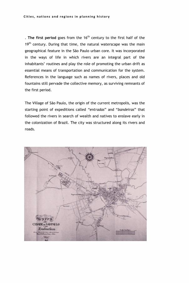
. The first period goes from the 16th century to the first half of the
19th century. During that time, the natural waterscape was the main
geographical feature in the São Paulo urban core. It was incorporated
in the ways of life in which rivers are an integral part of the
inhabitants’ routines and play the role of promoting the urban drift as
essential means of transportation and communication for the system.
References in the language such as names of rivers, places and old
fountains still pervade the collective memory, as surviving remnants of
the first period.
The Village of São Paulo, the origin of the current metropolis, was the
starting point of expeditions called “entradas” and “bandeiras” that
followed the rivers in search of wealth and natives to enslave early in
the colonization of Brazil. The city was structured along its rivers and
roads.

1 5 t h I N T E R N A T I O N A L P L A N N I N G H I S T O R Y S O C I E T Y C O N F E R E N C E
13
FIGURE 5 Early 19th century map showing São Paulo’s inhabited
areas and rivers. The Tamanduateí River is placing limits to the
historic center. The Tietê River, farther away to the North, is seen
on the left of the map. Source: COLEÇÃO DO QUARTO
CENTENÁRIO DA CIDADE DE SÃO PAULO, facsimile, 1954.
FIGURE 6 – View of the Tietê River in the city, with barges
carrying bricks close to Clube de Regatas [Regatta Club], 1905.
The second period, spanning between 1850 and 1930, saw the advent
of technological possibilities and choices that reshaped the
relationships between the city’s population and its rivers. With
possibility of supplying water through piping systems and bringing it
from increasingly distant areas, water sources were located farther
away for the city. As a result, the old public fountains disappeared
and in-home running water was introduced in the city by companies.
Consequently, the nearby rivers lost their importance as the City’s
water sources and started being considered obstacles to the urban
expansion.
On the other hand, amendments to real property laws in Brazil
starting 1850 sparked an interest in acquiring land as a form of

C i t i e s , n a t i o n s a n d r e g i o n s i n p l a n n i n g h i s t o r y
investment and integrated São Paulo city into the context of the new
global capitalism. That was also when the large companies responsible
for supplying infrastructure and new technologies arrived.
The installation of infrastructure within the new technological context
in Brazilian citiesat first as private enterprises and later as public
enterpriseshas been a major factor in environmental and landscape
changes, over the last one hundred years. Large foreign companies
such as The São Paulo Tramway, the Light and Power Company Ltd. or
the American Foreign Power Company all connected to the global
expansion of capitalism and some Brazilian capitalists of vision, in
individual, isolated initiatives, took charge of power supply and
transportation in recently founded capital cities.
The second phase of the European Industrial Revolution brought
technological industry, through these new products to be disseminated
throughout the Neocolonial world, and started reaching the Americas
in the second quarter of the 19th century.
In terms of water supply, the main focus of my previous studies14, a
major new development “mass-produced” by the Industrial Revolution
in the 19th century was the introduction of water pipe networks, which
replaced the old aqueducts, water collection directly from rivers by
water sellers15or the widespread open ditches connected to the public
fountains, where the population or slaves would collect water freely.
14 Kahtouni, Saide. Cidade das águas. São Paulo, FAUUSP. (doctoral thesis), 2003. 15 These sellers collected water in barrels and sold it door to door.

1 5 t h I N T E R N A T I O N A L P L A N N I N G H I S T O R Y S O C I E T Y C O N F E R E N C E
15
Concerning sewerage, Telles16 says that Rio de Janeiro was the fifth
city worldwide to have a sewerage system, even before major
European cities like Berlin (1874) and Rome (1879). In Rio de Janeiro
as well, the first pipes for underground connections, which brought
water from water sources to the public fountains, were imported from
Portugal as early as 1760. Incidentally, they were made of lead, a
material entirely inappropriate for this purpose. In São Paulo, a home
water supply networkmade of ironwas introduced only after 1876.
FIGURE 7. An 1855 map showing São Paulo City and its public
water supply tanks, developed by Eng. Rath. Source: Coleção do
Quarto Centenário da Cidade de São Paulo, facsimile, 1954.
Until 1860, São Paulo was supplied by water moving through open
ditches, pulled by gravity alone, from Tanque Reúno [Reúno Tank] to
Chafariz do Piques [Piques Fountain] and, later, to Jardim da Luz [Luz
Park] and to the public fountains. In 1855, there were a number of
16 Telles, Pedro Carlos da Silva . História da Engenharia no Brasil, Rio de Janeiro, Clube de Engenharia/Clavero, 1994, vol. 1.

C i t i e s , n a t i o n s a n d r e g i o n s i n p l a n n i n g h i s t o r y
different tanks (see Figure 7) interconnected with the fountain
system, which ceased to be used in 1893, after private sector
company Cantareira de Águas e Esgotos, established in 187717, was
taken over.
The possibility of having water supply reservoirs that received water
from more distant sources allowed the city to expand to its own
floodplains, thus stepping up the urbanization of its valley bottoms
and increasing pollution. Coincidentally, the first railroad stations and
water towers on metal stilts were built in major Brazilian cities as of
1860.
The construction of the first railroad in São Pauloa cutting-edge
infrastructure to carry passengers and cargocreated a new
transportation connection system in the city, which had been
structured along its port and road connections until then.
The city no longer needed its rivers as shipping routes and a new
cityscape emerged, characterized by industrialization and the
occupation of floodplains, at first that of the Tamanduateí River,
whose riparian zone was occupied by the Santos-Jundiaí railroad and
the large facilities of the first Brazilian factories, built along the river.
The Tamanduateí was straightened by Cel. Eng. Bresser in 1848, which
made it unnavigable and allowed the occupation of vacant land
between the railroad and the river.
The use of the city’s rivers as water sources was later abandoned as
well.
17Kahtouni, Saide. Cidade das águas, Rima editora, São Carlos, 2004 p.57-63.

1 5 t h I N T E R N A T I O N A L P L A N N I N G H I S T O R Y S O C I E T Y C O N F E R E N C E
17
FIGURE 8 STUDIES BY SATURNINO DE BRITO involving the
uptake of Tietê River water in São Paulo for water supply. The
project was abandoned. Source: Kahtouni, 2003.
The public works involving water resources created a new opportunity
for the city’s urbanized areas to grow. The land between the
Tamanduateí and the railroad became a new urban area, as shown in
the map above,
(FIGURE 9).

C i t i e s , n a t i o n s a n d r e g i o n s i n p l a n n i n g h i s t o r y
FIGURE 9 – São Paulo City plan by Cia. Cantareira de Águas e
Esgotos in 1881.The Tietê River can be seen to the North. The
Tamanduateí River and the new canals can be seen between the
center of the city and the railroad on the East. Source: Coleção do
Quarto Centenário da Cidade de São Paulo, facsimile, 1954.
On the other hand, the works of Companhia Light and its interest in
the Pinheiros River and its lands resulted in the construction of the
Guarapiranga and Billings Reservoirs, in 1907 and 1929 respectively.
In addition, the Pinheiros River was also straightened. The landscape
along the Pinheiros was altered by the Traição and Pedreira pumping
plants, used to control the flow of the river artificially and reverse its
course. The Sorocabana railroad and the electricity transmission
pylons and lines are part of this cityscape to this day.

1 5 t h I N T E R N A T I O N A L P L A N N I N G H I S T O R Y S O C I E T Y C O N F E R E N C E
19
FIGURE 10 – São Paulo City Plan drafted by Gomes Cardim in
1897.There are railroads and new housing developments in the
Tamanduateí and Tietê floodplains. Source: Coleção do Quarto
Centenário da Cidade de São Paulo, facsimile, 1954.
During the third period (1930 to now), the city started occupying its
floodplains, in a runaway expansion in these areas. The Plano de
Avenidas [Plan of Avenues], introduced during the mayoralty of
engineer Prestes Maia, included a system based on valley bottom
avenues and avenues running along the main rivers (Tietê and
Pinheiros) in which the car prevailed. The cityscape then started being
adapted to these new urban designsmost of which developed in the
U.S. in modern dayswhich are still being adopted throughout Brazil.
According to this vision, the backbone of the city’s road network
would be the avenues along its main rivers, and their tributaries would
serve as distributing axes of local traffic.

C i t i e s , n a t i o n s a n d r e g i o n s i n p l a n n i n g h i s t o r y
Transportation in the city became a basis for the economic progress
that served as a guideline for decisions.
FIGURE 11 – Prestes Maia and Ulhoa Cintra’s theoretical Plan of
Avenues. Source: TOLEDO, Benedito Lima de. Prestes maia e as
origens do urbanismo moderno em São Paulo. Santiago do Chile:
empresa das Artes, projeto e edições artísticas, 1996. P.160.
This technological model of reclaiming land from bodies of water and
disposing of urban waste mainly in rivers was devised in Ancient Rome
over two millennia ago, when the Cloaca Maxima and the Circus
Maximus were built on land drained and reclaimed from the Tiber
River. The magnificent Roman Forum was built on this great sewerage
system.
In the plan of Ancient Rome, the Palatine Hill could be compared with
the so-called São Paulo’s Central Triangle where as the Circus Maximus
Valley would correspond to the Anhangabaú Valley, both separating
two traditional central areas located on hills. Coincidentally, a Y-

1 5 t h I N T E R N A T I O N A L P L A N N I N G H I S T O R Y S O C I E T Y C O N F E R E N C E
21
shaped road system was created, based on the fork of the Via Appia
and the Via Latina. In São Paulo, the “Y” system was introduced by
Prestes Maia and is based on the fork of the 23 de Maio and the Nove
de Julho Avenues, which start in the Anhangabaú Valley and run along
two valley bottoms of its tributaries.
FIGURE 12 – Republican Rome and the Circus Maximus ( scheme
by Benevolo, 1983).

C i t i e s , n a t i o n s a n d r e g i o n s i n p l a n n i n g h i s t o r y
FIGURE 13 – The Y-system in the center of São Paulo City,
designed by Prestes Maia. Source: TOLEDO, Benedito Lima de.
Prestes maia e as origens do urbanismo moderno em São Paulo.
Santiago do Chile: empresa das Artes, projeto e edições artísticas,
1996. p. 171.
In addition to these works and engineering interventions, the intense
metropolization process of São Paulo starting in the 1960s brought an
excessive specialization in the management systems of the
infrastructures required by the city, thus leading to a fragmented
water resource managementa task shared by energy generation,
sanitation, flood control and drinking water supply agencies, as well
as contradictions and conflicts.
As a result, São Paulojust like other cities in their growth processes
has seriously damaged its water resources, which are increasingly
scarce worldwide and whose use and management have many aspects.
Consequently, the problems discussed at the beginning of this paper
have become extremely complex in modern-day São Paulo City due to
a historical process in which the urban space has been produced based
on the government’s public and political projects. In addition, the
engineering challenges have been handled in an isolated and
situational manner by the local government. A purely economic vision
of the city’s growth and planning prevailed, to the detriment of the
landscape and water resources.
In conclusion, currently, the São Paulo population is suffering due to
a scarcity of water and regular flooding of urban areas. We have
invaded the domain of water in an indiscriminate, unplanned manner.
The Tietê River is still a mere open sewage, in a metropolis with
millions of inhabitants.

1 5 t h I N T E R N A T I O N A L P L A N N I N G H I S T O R Y S O C I E T Y C O N F E R E N C E
23
FIGURE 14 – The Tiete River and the São Paulo downtown area. Source:
SATELLITE IMAGE / Google, 2000.
REFERENCES:
Anais do IV Dialogo Interamericano Das Águas, Foz do Iguaçu, 2001.
BACHELARD, Gaston. A água e os sonhos, ensaio sobre a imaginação
da matéria. Martins Fontes, São Paulo, 2002.
BRESSAN, Delmar. Gestão racional da natureza, São Paulo, Hucitec,
1996.
BENEVOLO, Leonardo. História da cidade. Perspectiva: São Paulo,
1983.
CHILDE. V. Gordon. O que aconteceu na história. Rio de Janeiro,
Zahar, 1978
CLARKE, Robin; KING, Jannet. O Atlas da água- o mapeamento
completo do recurso mais precioso do planeta. São Paulo: publifolha,
2005.

C i t i e s , n a t i o n s a n d r e g i o n s i n p l a n n i n g h i s t o r y
COUTO E SILVA, Golbery do. Conjuntura Política Nacional , o poder
executivo e geopolítico no Brasil. ( 2ª edição), Rio de Janeiro, José
Olympio, 1981.
ECKBO, Garret. The Landscape we see. USA, Hill Inc, 1969.
GLEICK, Peter H. The world's water 1998-1999, the biennal report on
Freshwater resources. Washington, Island Press, 1998.
JELLICOE, G. ; JELLICOE, S. El paysage del hombre, la conformacion
del entorno desde la prehistoria hasta nuestros dias. Barcelona :
Gustavo Gilli, 1995;
KAHTOUNI, Saide. Cidade das águas. São Paulo, FAUUSP, (Tese de
doutoramento), 2003.
KAHTOUNI, Saide . Cidade das águas, São Carlos, Rima, 2004.
LIEBMANN, Hans. Terra, um planeta inabitável? Da antiguidade até
nossos dias toda a trajetória poluidora da humanidade . Rio de
Janeiro, Biblioteca do Exército editora, 1979.
Mc HARG, Ian. Design with nature, New York ,The natural history
press., Garden City, 1969.
PROOST DE SOUZA, Saide K. Jardins e cidades, caminhos do
paisagismo, da jardinagem ao projeto ambiental, 1995, Revista
Projeto n. 190, outubro.
REBOUÇAS, Aldo. Uso inteligente da água. São Paulo, Escrituras, 2004.
(2008, second edition).
SANTOS, Milton. Metamorfoses do espaço habitado. HUCITEC, São
Paulo, 1994.
TELLES, Pedro Carlos da Silva . História da Engenharia no Brasil, Rio de
Janeiro, Clube de Engenharia/Clavero, 1994.

1 5 t h I N T E R N A T I O N A L P L A N N I N G H I S T O R Y S O C I E T Y C O N F E R E N C E
25
TOLEDO, Benedito Lima de. Prestes maia e as origens do urbanismo
moderno em São Paulo. Santiago do Chile: empresa das Artes, projeto
e edições artísticas, 1996.