sant'agostino, emilia romagna, italy e arthqu ke - 20/5 1 g … · the present map shows a...
TRANSCRIPT
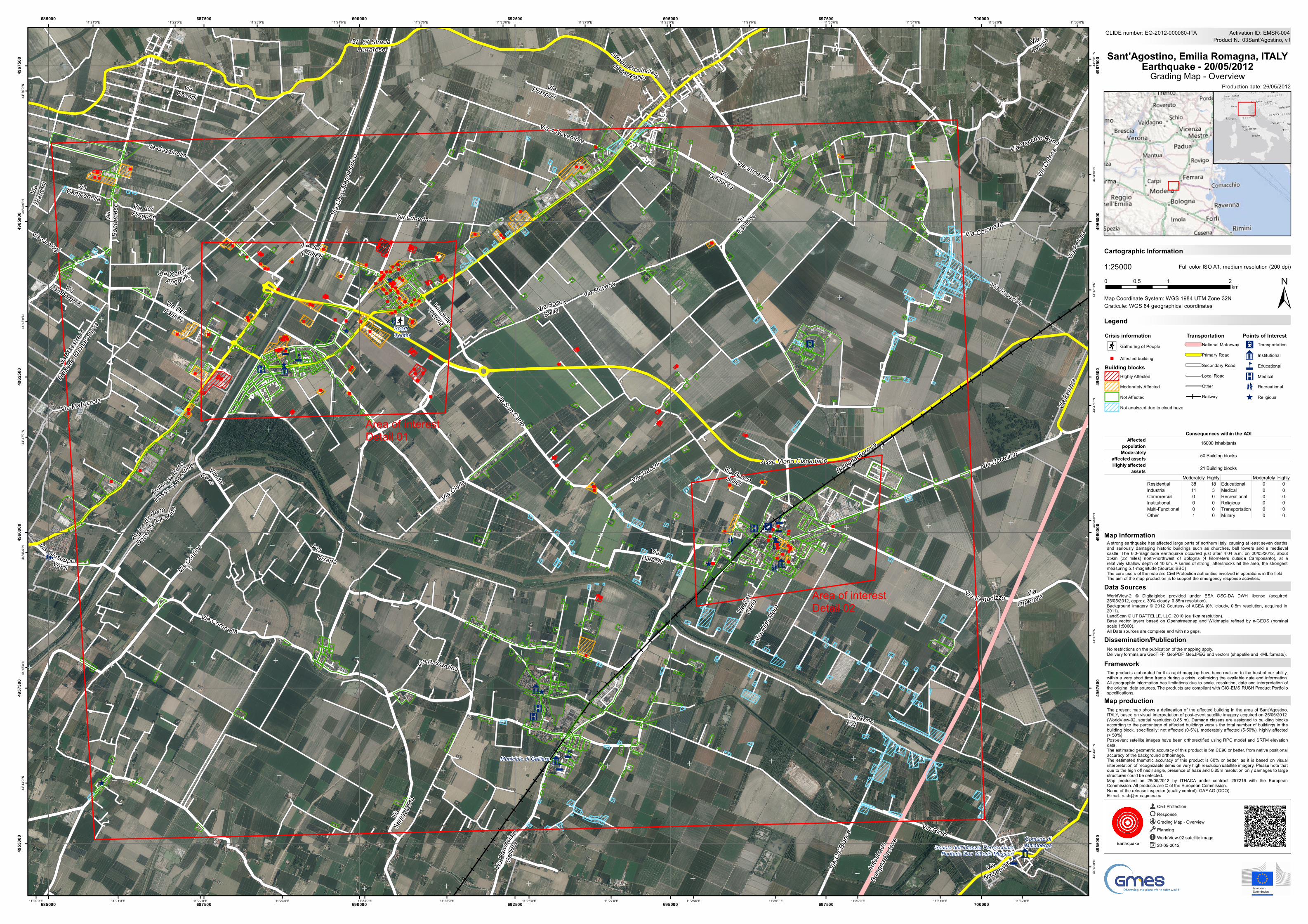
The present map shows a delineation of the affected building in the area of Sant'Agostino,ITALY, based on visual interpretation of post-event satellite imagery acquired on 25/05/2012(WorldView-02, spatial resolution 0.85 m). Damage classes are assigned to building blocksaccording to the percentage of affected buildings versus the total number of buildings in thebuilding block, specifically: not affected (0-5%), moderately affected (5-50%), highly affected(> 50%).Post-event satellite images have been orthorectified using RPC model and SRTM elevationdata.The estimated geometric accuracy of this product is 5m CE90 or better, from native positionalaccuracy of the background orthoimage.The estimated thematic accuracy of this product is 60% or better, as it is based on visualinterpretation of recognizable items on very high resolution satellite imagery. Please note thatdue to the high off nadir angle, presence of haze and 0.85m resolution only damages to largestructures could be detected.Map produced on 26/05/2012 by ITHACA under contract 257219 with the EuropeanCommission. All products are © of the European Commission.Name of the release inspector (quality control): GAF AG (ODO).E-mail: [email protected]
Crisis information;Ø Gathering of People
" Affected buildingBuilding blocks
HIghly AffectedModerately Affected
Not Affected
Not analyzed due to cloud haze
TransportationNational MotorwayPrimary Road
Secondary Road
Local RoadOther
Railway
Points of InterestX Transportation
9 Institutional
4 Educational
K Medical
m Recreational
^ Religious
9
^9^
9
^
^
m
K 4
K
^
K
X
m
4
m
4
m
^
^
9
4
^
X
9
9
^
K
4
4
4
^
;Ø
"
"
""
" ""
"
"
""
" "
"
"
"
" "
"
""
"""
""
"
"
"
"
"
"""
"
""
"
"
""
"
"""
"""
"
"
"""
"
""
"
"
"
"
""
"
"
"
"
"
"
"
"
"
"
"
"
"
"
"
"
"
"
"
"
"
"
" "
"
" ""
"
"
"
""
"
"
"
"
"
"
"
"
"
"
"
"
"
"
"
"
"
""
"
"
"
"
"
"
"
"
"
"
"
"
"
"
"
"
"
"
""
"
"
"
"
"
"
"
" "
"
"
"
"
"
""
"
"
"
"
"
"
"
"
"
"
"
"
"
"
"
"
""""
"
"
via Gazzinella
Via del
Cavo
Via Riolo
Via Pr
ovinc
iale Ga
lliera
Via Ciarle
Via Imperiale
SP 67 Strada Ferrarese
Via dei Frutteti
via Maes
tra in
Frazio
ne Bu
onacom
pra
Via Uccellino
Via Fe
rrara
Via Sa
n Ca
rlo
Via Imperiale
Asse Viario Cispadano
Via Coronella
Via Ald
o Moro
Autos
trada
Bolog
na-Pa
dova
Via Raveda
Via Cant
one
Via Pia
ntoni
Via Canale Angel ino
Via Lamborghini
Via Orologi
Via San Carlo
Via Bosco Salici
Via Nazionale
Via Bosco Salici
Via Imperiale
Via delle
Donne
Via Coronel la
V ia bisana
Via Giuseppe Verdi
via Campedella
Via Ca
' Bian
ca
via Bastardina
Via Vecchio Reno
Via Tracchi
Via Pe
losa
Via dei Pioppeti
Via Prosperivia Casoni
Via Confine
Via Del Fantino
Argine dx
Reno
Dosso-S.
Ago st ino
Via Matazzola
Via Giovecca
Via Ca
tena
Via Luneda
Argine sx Reno
Dosso-S.Agostino
Via 4 Novembre
Via Segadizzo
Via Sa
nt'Albe
rto
Via Ca
vo Na
poleo
nico
Strada Provinciale
di Correggio
Via Bianchi
Via Ladin o
Via Bo
n de n
e se
Via Reno Est
Comune diMalalbergo
Municipio di Galliera
SportCenter
Scuola dell'infanzia ParrocchialeParitaria Don Vittorio Messieri
Bologna-Ferrara
11°33'0"E
11°32'0"E
11°32'0"E
11°31'0"E
11°31'0"E
11°30'0"E
11°30'0"E
11°29'0"E
11°29'0"E
11°28'0"E
11°28'0"E
11°27'0"E
11°27'0"E
11°26'0"E
11°26'0"E
11°25'0"E
11°25'0"E
11°24'0"E
11°24'0"E
11°23'0"E
11°23'0"E
11°22'0"E
11°22'0"E
11°21'0"E
11°21'0"E
11°20'0"E
44°5
0'0"N
44°5
0'0"N
44°4
9'0"N
44°4
9'0"N
44°4
8'0"N
44°4
8'0"N
44°4
7'0"N
44°4
7'0"N
44°4
6'0"N
44°4
6'0"N
44°4
5'0"N
44°4
5'0"N
44°4
4'0"N
44°4
4'0"N
44°4
3'0"N
685000
685000
687500
687500
690000
690000
692500
692500
695000
695000
697500
697500
700000
700000
4955
000
4955
000
4957
500
4957
500
4960
000
4960
000
4962
500
4962
500
4965
000
4965
000
4967
500
4967
500
GLIDE number: EQ-2012-000080-ITA
Production date: 26/05/2012
Cartographic Information
1:25000
±Map Coordinate System: WGS 1984 UTM Zone 32N
Full color ISO A1, medium resolution (200 dpi)
The products elaborated for this rapid mapping have been realized to the best of our ability,within a very short time frame during a crisis, optimizing the available data and information.All geographic information has limitations due to scale, resolution, date and interpretation ofthe original data sources. The products are compliant with GIO-EMS RUSH Product Portfoliospecifications.
No restrictions on the publication of the mapping apply.Delivery formats are GeoTIFF, GeoPDF, GeoJPEG and vectors (shapefile and KML formats).
A strong earthquake has affected large parts of northern Italy, causing at least seven deathsand seriously damaging historic buildings such as churches, bell towers and a medievalcastle. The 6.0-magnitude earthquake occurred just after 4:04 a.m. on 20/05/2012, about35km (22 miles) north-northwest of Bologna (4 kilometers outside Camposanto), at arelatively shallow depth of 10 km. A series of strong aftershocks hit the area, the strongestmeasuring 5.1-magnitude (Source: BBC)The core users of the map are Civil Protection authorities involved in operations in the field.The aim of the map production is to support the emergency response activities.
LegendGraticule: WGS 84 geographical coordinates
Product N.: 03Sant'Agostino, v1Activation ID: EMSR-004
WorldView-2 © Digitalglobe provided under ESA GSC-DA DWH license (acquired25/05/2012, approx. 30% cloudy, 0.85m resolution).Background imagery © 2012 Courtesy of AGEA (0% cloudy, 0.5m resolution, acquired in2011).LandScan © UT BATTELLE, LLC. 2010 (ca 1km resolution).Base vector layers based on Openstreetmap and Wikimapia refined by e-GEOS (nominalscale 1:5000).All Data sources are complete and with no gaps.
Civil ProtectionResponseGrading Map - OverviewPlanningWorldView-02 satellite image20-05-2012Earthquake
0 1 20.5km
Sant'Agostino, Emilia Romagna, ITALYEarthquake - 20/05/2012
Grading Map - Overview
Map production
Framework
Dissemination/Publication
Data Sources
Map Information
Area of interestDetail 01
Area of interestDetail 02
AffectedpopulationModerately
affected assetsHighly affected
assetsModerately Highly Moderately Highly
Residential 38 18 Educational 0 0Industrial 11 3 Medical 0 0Commercial 0 0 Recreational 0 0Institutional 0 0 Religious 0 0Multi-Functional 0 0 Transportation 0 0Other 1 0 Military 0 0
21 Building blocks
16000 InhabitantsConsequences within the AOI
50 Building blocks