santa rita ema - sky island action center
TRANSCRIPT

www.skyislandaction.org 5-1 State of the Coronado Forest DRAFT 11.05.08
Nogales RANGER DISTRICT

DRAFT 11.05.08 State of the Coronado Forest 5-2 www.skyislandaction.org

CHAPTER 5 Santa Rita Ecosystem Management Areaaround the world. Gardner Canyon, located on theeast side of the mountain range, is also a popularrecreation destination offering uncrowded hikingaccess to Mt. Wrightson Wilderness, a variety ofwildlife, and stunning views. Located only 30 milessouth of the town of Tucson, Arizona, the distinctridgeline of these mountains and the prominent peakof Mount Wrightson are clearly visible from the city.Traveling south on Interstate 19, one passes throughthe retirement community of Green Valley locatednear the western side of the range. The scenic bywayof State Highway 83 travels along the eastern side ofthe range through the communities of Patagonia, andSonoita. The southern tip of the range is only a fewmiles for the U.S.-Mexico border and the border townof Nogales.
Waters running west off the Santa Rita crest pourinto the Santa Cruz watershed and feed washesrunning through the Santa Rita Experimental Rangeand into the community of Corona de Tucson. On theeastside of the range, Papago Canyon connects toDavidson Canyon, a critical wildlife linkage for speciesmoving between the Santa Rita Mountains, CienegaCreek and the Rincon and Catalina Mountains. Theeastern edge of the Santa Rita management areaborders the Sonoita Valley, a relatively intact grassland.Waters running off from the Santa Ritas feed CienegaCreek as it runs through the heart of Las CienegasNational Conservation Area. Sonoita Creek is fed byeastern and southern flanks of the mountains. The
The Santa Rita Mountains harbor densely wooded,well-watered canyons and boast steep ruggedridgelines and hillsides. Located in the westernportion of the Coronado National Forest, the SantaRita Ecosystem Management Area (EMA)encompasses 148,425 acres with elevations rangingfrom 3,600 feet to 9,450 feet at the summit of Mt.Wrightson. The northwestern side of the ManagementArea is bordered by Santa Rita Experimental Range,80,000 acres of low elevation rangeland managed bythe University of Arizona. The area is used to conductrangeland studies on recovery from drought andsustainable grazing practices among other things.Much of the northeastern and northwestern portionsof the area is bordered by state land, while most of thesouthern portions are bordered by private land.Rosemont Ranch, a key parcel of private landbordering the northwestern side of the range, waspurchased in 2005 by August Resource, a smallCanadian mining company. As of 2008 this ranch isthe proposed site of an open pit copper mine that willutilize a portion of Forest lands in the Santa RitaEcosystem Management Area.
The Santa Rita Mountains have long been acherished recreation destination for Tucsonans andother southern Arizona inhabitants that engage inhiking, bird watching, mountain biking, hunting,camping and a variety of other uses. The Santa Ritasare one of the big three ecotourism destinations in theregion with Madera Canyon drawing birders from
www.skyislandaction.org 5-3 State of the Coronado Forest DRAFT 11.05.08

DRAFT 11.05.08 State of the Coronado Forest 5-4 www.skyislandaction.org
Figure 5.1 Overview of the Santa Rita EMA

Patagonia-Sonoita Creek Preserve also encompassesriparian habitat fed in part by runoff from the SantaRitas. Owned by The Nature Conservancy, thepreserve is home to rare fish, frogs and plants, andover 200 species of birds have been recorded there.
Natural HistoryThe Santa Rita Mountains are renowned for the
occurrence of a number of Mexican bird speciesassociated with the Sierra Madre Occidental, andwhose range in the U.S. is quite limited. Deep anddensely wooded Madera Canyon on the northwesternflanks of the Santa Rita Mountains harbors springsand perennial pools, providing outstanding habitat forover 250 species of birds along with rare amphibians.sky island “specialties” including Elegant Trogon andYellow-eyed Junco can be found in the oak woodlandsand pine-oak forests of the upper canyon, along withoccasional rarities such as Flame-colored Tanager andAztec thrush. Between 1,000 to 1,500 varieties ofplants can be found in the Canyon contributing to thegreat diversity of habitats and animal life. To the northof Madera Canyon lies Florida Wash, also known forits excellent bird habitat. Neotropical Varied Buntingscan be spotted along the wash and nest in the area.Temporal Gulch in the southern Santa Rita Mountainssupports a native assemblage of longfin dace, speckleddace and desert sucker. Cassin and Botteri sparrowsalso nest in the area in semi-desert grasslands.Temporal Gulch is a tributary to Sonoita Creek and asurface water connection between the two exits oftenenough to provide for genetic interchange andrecolonization of fish.1 On the west side of the range,desert grassland communities are located in AguaCaliente Canyon and Devil's Cashbox Canyon.
Davidson Canyon at the north end of the range isone of the most important wildlife corridors betweenthe Santa Rita Mountains and the Rincon, SantaCatalina and Galiuro Mountains located to the north.A variety of wide-ranging animals includingmountain lions, bears, and coatimundi utilize thisessential linkage.
Human Prehistory and HistoryHumans have been an important component
of the sky island landscape for at least 10,000 yearsand the Santa Rita Mountains are rich in humanhistory and pre-history. They have been home toApaches, Mexican campesinos, Anglo ranchers,miners, loggers, mission dwellers, and cavalrymen.Prehistoric cultures hunted Pleistocene mammoths in
the San Pedro Valley east of the Santa Ritas thenmoved to hunting small game and gathering foodplants as the climate changed. The Santa Cruz Valleyjust west of the Santa Ritas became the site ofcultivation of domestic plants. Rock pile sites in themountains are potential remnants of dry farming,water capture methods used by early agriculturalcultures. Around A.D. 550 to 750 Hohokam styles ofarchitecture, graphic symbols, and burial practicesspread into the Santa Cruz Valley and surroundingmountains. A Hohokam burial site found to contain75 individuals, and funerary objects such as ceramicbowls, jars, shell, bone and turquoise ornaments wasexcavated in the Santa Ritas.2 Hohokam village sitesexist in the Rosemont area and on the bajada thatstretches out below Madera Canyon. Fourteen studysites in the area have revealed Hohokam presencefrom approximately 500 to 1225 A.D.
Around A.D. 14002 the Hohokam culture in theSanta Cruz River Valley collapsed due in part tochanging environmental conditions. Pima tribes(Akimel O’odham) lived in the San Pedro Valley andthe area of present-day Las Cienegas, and utilized theSanta Rita Mountains until they were eventuallydisplaced by Apache. They were known to have livedin the area of Rosemont from approximately 1650 to1780 A.D. These people were still living in the areawhen Apaches arrived from the north and beganraiding villages, and Spaniards arrived from the southand began establishing cattle ranches.
By the 1880s the Santa Rita Mountains had beenextensively prospected and many mines had beenestablished. The western side of the Santa Ritas wasthe location of a mine run by the Santa Rita SilverMining Company. The Greaterville area at the easternfoot of the range was the site of a number of GoldPlacers. This area proved to be one of the largest andrichest placer grounds in southern Arizona and anumber of mining camps sprang up in the area.Gardener Canyon was the nearest source of water, anecessity for placer mining, and when runoffdissipated in the canyon, miners bought water thathad been packed in on burros. By 1881 much of thereadily accessible gold in the area had been extractedand mining began to cease in the area. At the northernend of the Santa Ritas, the Helvetia and Rosemontmining districts where the site of a number of boomand bust copper mining operations. Mining claimshad been staked as early as 1879 with major copper
www.skyislandaction.org 5-5 State of the Coronado Forest DRAFT 11.05.08

production occurring between 1915 and 1918.During this time period the mining camp of NewRosemont grew to two hundred inhabitants beforemining operations ceased when copper pricesplummeted in 1921.3
Over 100 years ago, Madera Canyon was the site ofextensive logging that provided timber to the city ofTucson. The area was the site of the first sawmill inArizona run by Bill Kirkland in 1857. Madera meanslumber, or wood in Spanish. The value of Madera
Canyon as wildlife habitat, and a cool refuge fromdesert heat quickly replaced its value for timberharvest and today the Canyon remains a popularrecreational destination.
Whipple Observatory is located on MountHopkins near the middle of the range. This areaextending through the north end of the range offerssome of the best dark sky astronomy conditions in theregion.
DRAFT 11.05.08 State of the Coronado Forest 5-6 www.skyislandaction.org
and biological processes. Using this classificationallows current vegetation to be compared effectively tovegetation under historic conditions. BecausePotential Natural Vegetation Types are relatively broadgroupings, and because the Forest contains a highdiversity of vegetation types, we present ecologicalsystems as a focus for management direction. Theseecological systems are cross-walked with the PotentialNatural Vegetation Types used by the Forest Service(Table 5.2). Although there are many fine variations inplant communities on the Santa Rita EcosystemManagement Area, ecological systems classify plantcommunities into broader groups so as to be mostuseful for management actions such as mapping, landmanagement, and monitoring. Plant communitieswere grouped based on shared characteristics such asnatural processes (e.g. fire and flood), substrates (e.g.shallow soils, limestone outcroppings), and localclimate.4 Figure 5.2 shows the distribution ofecological systems in the Santa Ritas. Through contactwith regional scientists and experts, and other peoplefamiliar with the Santa Ritas, we identified ecologicalsystems, physiographic features, additional species andcultural resources that should also be considered inthe Forest Plan revision.
The Santa Rita Mountains contain a wealth ofprehistoric and historic influences. Visible andphysical remnants of previous human habitation ofthe area include built structures, physical sites, orobjects or assemblages of material culture. Humanuses of the land compatible with the protection ofbiological diversity are also an important part of theCultural Heritage of the area (Table 5.4).
The Santa Rita Ecosystem Management Areaharbors a unique combination of vegetation types andspecies that contribute to the biological diversity ofthe Coronado National Forest. The Forest Servicerecognizes that building a framework for ecologicalsustainability will require management of entirebiological communities combined with specialmanagement for particular species. For revision of theForest Plan the Forest Service identified species thatwill be the focus of planning efforts. Species andvegetation types of management interest found acrossthe Coronado National Forest were described andlisted in the Forest Overview (Table 1.1, page 1-11).Described here are species and vegetation typesspecifically found on the Santa Rita EcosystemManagement Area. In this management area, theForest Service identified 118 species of plants andanimals including six Threatened or Endangeredspecies, along with other species determined to beSpecies of Concern or Species of Interest (Table 5.1).These species will be used to guide managementdecisions.
Ecological systems and the processes that sustainthem are the foundations of native biological diversity.Vegetation communities and aquatic habitats that areespecially species rich, diverse, or threatened; or areendemic to the region or locality are of particularmanagement concern. To evaluate current conditionsand management prescriptions for ecological systemsthe Forest Service is using the framework of PotentialNatural Vegetation Types. Potential Natural VegetationTypes are defined as the vegetation that woulddominate a site under natural disturbance regimes
Elements of Biological Diversity and Cultural Heritage

www.skyislandaction.org 5-7 State of the Coronado Forest DRAFT 11.05.08
Figure 5.2 Ecological Systems of the Santa Rita EMA

DRAFT 11.05.08 State of the Coronado Forest 5-8 www.skyislandaction.org
AmphibiansEleutherodactulus augusti cactorumRana chiricahuensisRana tarahumarae
BirdsAmmodramus savannarum
ammolegusCoccyzus americanus occidentalisCyrtonix montezumaeEmpidonax fulvifrons pygmaeusGlaucidium brasilianum cactorumMeleagris gallopavo mexicanaPolioptilla nigricepsTrogon elegans
CheliceratesStygobromus arizonensis
FishAgosia chrysogasterCatostomus clarkiiCatostomus insignis
InsectsAdopaeoides prittwitziHeterelmis stephaniOligocentria delicataOphiogomphus arizonicusSpeyeria nokomis coerulescensSphingicampa raspa
MammalsChoeronycteris mexicanaLasiurus blossevilliiMacrotus californicusNyctinomops femorosaccusPanthera oncaSciurus arizonensis Sorex arizonaeThomomys umbrinus intermedius
MollusksSonorella clappi
Plants: Non-vascular Heterodermia appalachensisLeptogium rugosumOmphalora arizonica
Western Barking FrogChiricahua Leopard FrogTarahumara Frog
Arizona Grasshopper Sparrow
Western Yellow-billed CuckooMontezuma QuailNorthern Buff-breasted FlycatcherCactus Ferruginous Pygmy-owlGould's TurkeyBlack-capped GnatcatcherElegant Trogon
Arizona Cave Amphipod
Longfin DaceDesert SuckerSonora Sucker
Sunrise SkipperStephan's Heterelmis Riffle A Notodontid MothArizona SnaketailBluish FritillaryA Royal Moth
Mexican Long-tongued BatWestern Red BatCalifornia Leaf-nosed BatPocketed Free-tailed BatJaguarArizona Gray SquirrelArizona ShrewSouthern Pocket Gopher
Madera Talussnail
Rugos skin lichen
Plants: Vascular Abutilon parishiiAcacia millefoliaAgastache rupestrisAgave parviflora ssp. parvifloraAmoreuxia gonzaleziiArabis tricornutaAsclepias lemmoniiAyenia truncata (= A. glabra)Boerhavia megapteraBouteloua eludensBouteloua parryiCarex ultraCastilleja nervataConioselinum mexicanumCoryphantha scheeri var. robustispinaDelphinium scopulorumDrymaria effusa var. effusaErigeron arisoliusErigeron lemmoniiErigeron pringleiEryngium sparganophyllumEscobaria vivipara var. bisbeeanaFraxinus papillosaHackelia ursinaHeterotheca rutteriHexalectris revolutaHexalectris spicata var. arizonicaHymenoxys quinquesquamataIpomoea plummerae var. cuneifoliaIpomoea tenuiloba var. lemmoniiIpomoea thurberiLaennecia eriophyllaLilium parryiLupinus huachucanusMacromeria viridiflora var. thurberiMacromeria viridiflora var. viridifloraMalacothrix stebbinsiiMammillaria grahamii var. oliviaeMammillaria heyderi var.
macdougaliiMammillaria wrightii var. wrightiiManihot davisiaeMargaranthus solanaceusMimulus dentilobusMuhlenbergia elongata (=M.
xerophila)Muhlenbergia palmeri (=M.
dubioides)Opuntia phaeacsntha var. laevisPaspalum virletii
Pima Indian MallowMilfoil AcaciaThread-leaf Giant-hyssop
Santa Rita YellowshowRincon Mountain RockcressLemmon MilkweedAyeniaTucson Mountain SpiderlingSanta Rita GramaParry's GramaCochise SedgeTrans-Pecos Indian PaintbrushMexican Hemlock-parsleyPima Pineapple CactusRocky Mountain LarkspurPinewood DrymaryArid Throne FleabaneLemmon's FleabanePringle's FleabaneArizona EryngoBisbee's Pincushion CactusChihuahua AshChihuahuan StickseedRutter's Golden-asterChisos CoralrootCrested CoralrootRincon BitterweedHuachuca Mountain Morning-gloryLemmon's Morning-gloryThurber's Morning-gloryCochise WoolwortLemon Lily Huachuca Mountain LupineGiant-trumpetsGiant-trumpetsStebbins Desert-dandelion
Little Nipple Cactus
Wright Fishhook CactusArizona ManihotNetted GlobeberrySouthwest MonkeyflowerSycamore Muhly
Southwestern Muhly
New Mexico Prickly-pearVirlet's Paspalum
Table 5.1 Species Identified by the Forest Service to Guide Management Decisions
continued

www.skyislandaction.org 5-9 State of the Coronado Forest DRAFT 11.05.08
Pectis imberbisPenstemon superbusPerityle dissectaPhaseolus supinusPhoradendron bolleanum ssp.
pauciflorumPlagiobothrys pringleiRhamnus crocea ssp. pilosaRoldana hartwegii (=Senecio
hartwegii, with syn = S. seemannii, S.carlomasonii, & R. carlomasonii)
Samolus vagansScutellaria tessellataSenecio multidentatus var.
huachucanusSisyrinchium cernuumViguiera dentata var. lancifoliaWoodsia cochisensis
ReptilesAspidoscelis burti stictogrammaCrotalus priceiCrotalus w. willardi Sceloporus sleviniTantilla wilcoxiThamnophis eques megalops
Beardless Chinch WeedSuperb BeardtongueSlimlobe RockdaisySupine BeanRough Mistletoe
Pringle's Popcorn-flowerRedberry BuckthornSeemann (Hartweg's) Groundsel
Chiricahua Mountain BrookweedHuachuca Mountains SkullcapHuachuca Groundsel
Nodding Blue-eyed GrassSunflower Golden-eyeCochise Woodsia
Canyon Spotted WhiptailTwin-spotted RattlesnakeArizona Ridge-nosed RattlesnakeSlevin's Bunchgrass LizardChihuahuan Black-headed SnakeNorthern Mexican Gartersnake
Table 5.1 Species Identified by the Forest Serviceto Guide Management Decisions continued
Table 5.2 Foundations of Native BiologicalDiversity
“Potential Natural Vegetation Types” (bold) as theycorrespond with The Nature Conservancy’s “EcologicalSystems”_______________________________________
Desert CommunitiesChihuahuan Desert Scrub Sonoran Paloverde Mixed-Cacti Desert Scrub
Interior ChaparralInterior Chaparral
Madrean Encinal WoodlandsMadrean Encinal
Madrean Pine-Oak WoodlandMadrean Oak-Pine Woodland
Mixed Broadleaf Deciduous Riparian ForestMontane Riparian Woodland and Shrubland
Mixed Conifer ForestMontane Mixed-Conifer Forest
Semi-desert grasslandsApachean Grassland and SavannahApachean Shrubland Apachean Riparian Grassland
Wetland/CienegaCienega
Physiographic Features______________________________
Limestone and Rhyolite Outcroppings
Community______________________________
Sacaton Riparian Grassland

DRAFT 11.05.08 State of the Coronado Forest 5-10 www.skyislandaction.org
AmphibiansRana yavapaiensis
BirdsAimophila botterii Aimophila carpalis Aimophila cassiniiAmazilia beryllinaAmmodramus bairdiiAsturina nitida maxima Athene cunicularia hypugaea Buteo albonotatus Buteogallus anthracinus Callipepla squamata Camptostoma imberbeCeryle alcyon Colaptes chrysoidesHylocharis leucotisMegascops trichopsisPipilo abertiProgne subis Vermivora luciaeVireo bellii
FishGila intermedia Poeciliopsis occidentalis occidentalis
InsectsAbedus herberti Adopaeoides prittwitzi Ancyloxypha arene Calephelis arizonensisTuberochernes ubicki
MammalsCorynorhinus townsendii pallescensCynomys ludovicianus
Lowland Leopard Frog
Botteri's Sparrow Rufous-winged Sparrow Cassin's SparrowBerylline HummingbirdBaird's SparrowNorthern Gray Hawk Burrowing Owl Zone-Tailed Hawk Common Black-Hawk Scaled Quail Northern Beardless-TyrannuletBelted Kingfisher Gilded FlickerWhite-eared HummingbirdWhiskered Screech OwlAbert's TowheePurple MartinLucy's WarblerBell's Vireo
Gila Chub Gila Topminnow Infraspecific.
Giant Water Bug Sunrise Skipper Tropical Least Skipper Arizona MetalmarkA Cave Obligate Pseudoscorpion
Pale Lump-nosed Bat Black-Tailed Prairie Dog
Myotis ciliolabrumMyotis thysanodes Myotis veliferPeromyscus merriamiSigmodon ochrognathus
PlantsAmsonia grandifloraAsclepias uncialisAstragalus hypoxylusBrowallia eludensDryopteris patula var. rossii Echinomastus erectocentrus var.
erectocentrusEuphorbian macropusGraptopetalum bartramiiHexalectris revoluta Hieracium pringlei Hieracium rusbyiLilaeopsis schaffneriana var. recurvaMetastelma mexicanum
Rumex orthoneurusSenecio huachucanusSpiranthes delitescensTalinum humile
Talinum marginatum
ReptilesCnemidophorus burti stictogrammusCoralus lepidusEumeces callicephalusGonyosoma oxycephelaLampropeltis pyromelanaPhrynosoma cornutum
Western Small-Footed Myotis Bat Fringed Myotis Bat Cave Myotis BatMesquite MouseYellow-Nosed Cotton Rat
Arizona SlimpodGreene MilkweedHuachuca MilkvetchElusive New Browallia SpeciesMexican Shield Fern Needle-spined Pineapple Cactus
Woodland SpurgePatagonia Mountain Leather-PetalChisos Coral-Root Pringle's Hawkweed Rusby's HawkweedAffolterNorrowleaf Or Wiggin's Swallow
WortBloomer's DockHuachuca GroundselCanelo Hills Ladies' Tresses Orchid Pinos Altos Mountains Flame
Flower Tepic Flame Flower
Canyon Spotted WhiptailMountain SkinkRock RattlesnakeGreen Rat SnakeMountain KingsnakeTexas Horned Lizard
Table 5.3 Additional Species that Require Special Management Consideration
Table 5.4 Elements of Cultural Heritage
Pre-Historic and Historic ElementsPhysical sites utilized by Native AmericansMines, camps, mills and mining towns in Rosemont Valley
Other ValuesOpportunities for quiet and solitudeOpportunities for primitive recreation

www.skyislandaction.org 5-11 State of the Coronado Forest DRAFT 11.05.08
� The Santa Rita EMA remains situated in a landscapein which wide-ranging species (black bear, mountainlion, deer, pronghorn, Mexican gray wolf, jaguar, coati,and others) are able to move between the Santa RitaEMA and the following: Tumacacori EMA, HuachucaEMA, Santa Catalina EMA, Dragoon EMA, theCienega Creek corridor and other surroundingwildlands.
� Development around the Santa Rita EMA does notprevent the continued use of prescribed fire andwildland fire as management tools.
� The Santa Rita EMA contributes to the health andrecharge of the Cienega Creek watershed.
� Human uses on the Santa Rita EMA are in bothshort-term and long-term harmony with theecological health of the land.
� No new mines are developed in the Santa RitaMountains.
� The Santa Ritas continue to be a high qualitylocation for primitive recreation with opportunities toexperience quiet and solitude. Wildlife and humanvisitors are free from direct disturbance and noise.
Desired Conditions
Conservation assets work on behalf of Foresthealth on the Santa Rita Ecosystem Management Area.They will contribute to the Forest Service’s ability tomaintain ecological sustainability on the ManagementArea. The following emerged as strengths andopportunities for conservation on the Santa RitaEcosystem Management Area.
Friends of Madera CanyonFriends of Madera Canyon was established to
advance historical, scientific, educational, andinterpretive programs in Madera Canyon. The groupworks to heighten public interest in the Santa RitaMountains and conservation through educationprograms. They also assist the Forest Service in itsoperations, assist in data gathering and publicfeedback, and generally assist the Forest Service in itseffort to provide rewarding recreational opportunitiesfor all visitors.
Santa Rita Experimental RangeThe Santa Rita Experimental Range encompasses
roughly 80,000 acres on the northern side of the SantaRitas much of which is directly adjacent to Forest land.The Experimental Range, established in 1902 to studyrange recovery from drought and overgrazing as wellas sustainable grazing practices, is the oldest in thecountry. It spans from the Sonoran desert atapproximately 3,000 feet of elevation to semi-aridgrassland scrub at 4,500 feet of elevation. The range
and contiguous Forest lands form a gradient ofprotected land stretching from below 3,000 feetelevation up to 9,000 feet elevation and encompassinga variety of distinct life zones.
Santa Rita Important Bird AreaThe Santa Rita Important Bird Area encompasses
the area of Madera Canyon and the Mt. WrightsonWilderness above 4,500 feet elevation. The habitatconsists of oak-woodland, transitioning to pine-oakwoodland, and finally mixed conifer at the highestelevations. The drainages of the area support riparianhabitat consisting of ash cotton wood and sycamore.The IBA supports Species of Conservation Status ofthe Sierra Madre bird community including: NorthernGoshawk, Gray Hawk, Mexican Spotted Owl,Whiskered Screech-owl, Montezuma Quail, ElegantTrogon (within seven canyons), Arizona Woodpecker,Violet-crowned Hummingbird, LuciferHummingbird, Costa’s Hummingbird, BeryllineHummingbird, White-eared Hummingbird, PaintedRedstart, Red-faced Warbler, Grace's Warbler, OliveWarbler, and Varied Bunting.
Save the Scenic Santa RitasSave the Scenic Santa Ritas is a grassroots
organization that formed in 1996 in response to aproposed land exchange between the CoronadoNational Forest and ASARCO mining company. Theland exchange was a step toward opening an open pitcopper mine in the Santa Rita Mountains. The group
Conservation Assets

DRAFT 11.05.08 State of the Coronado Forest 5-12 www.skyislandaction.org
The Coronado National Forest and surroundinglands have experienced a variety of changes in thetwenty years since the current Forest Plan was written.Management concerns and threats exist in the SantaRitas that are not addressed in the Forest Plan, or havenot been adequately dealt through management. Theplan revision will update existing managementdirection and add new management direction, both ofwhich should address these concerns. The followingissues present challenges to ecological sustainabilityon the Santa Rita Ecosystem Management Area.
ADJACENT LAND USESA large suburban development is currently being
considered in lands just to the northeast of theentrance to Madera Canyon. The development wouldpotentially contain 180 new homes on a 744.4-acreparcel. This type of development will directly affectwildlife corridors leading north and west from MaderaCanyon along with affecting the nature of the northside of the range.
ECOLOGICAL RESTORATIONThreats include the suppression of natural fire
regimes, and changes in natural watershed function/flow regimes. Direct impacts include:
� Changes in overstory and understory structure offire adapted vegetation types
� Encroachment of woody species
� Structurally denser vegetation with higher fuel loads
� Increased potential for stand-replacing fires
� Decreases in overall water infiltration in uplandareas
� Lowering of local water tables
� Downcut streambeds
Affected resources include: Chihuahuan pinestands and associated species (Northern goshawk,
Mexican spotted owl), riparian-dependent species,native fish, northern Mexican Gartersnake, Sonoranmud turtle, Chiricahua leopard frog, neotropicalmigrant birds.
EXTRACTIVE USESMiningThe Helvetia area near the northwest side of the
EMA is currently the site of limestone extraction. Thelimestone transport takes place over a dirt road andthe limestone dust rising from transport trucks can beseen for miles. Several more limestone mines havebeen proposed just to the north and east of the EMA.
As of May, 2008 Augusta Resource, a smallCanadian Mining company, is proposing an open pitCopper Mine on their Rosemont Ranch property onthe northwest side of the range. The mine is proposedto be partially located on National Forest land. Theproposed mine threatens water and air quality,recreation opportunities, wildlife and wildlife habitatand economic sustainability on the Santa RitaEcosystem Management Area. The northern portionof the Santa Rita Mountains feeds into the watershedof the Tucson basin and surrounding communities.The Arizona Game & Fish Department expressed theirview in July of 2008 that the proposed mine would"render the northern portion of the Santa RitaMountains virtually worthless as wildlife habitat andas a functioning ecosystem, and thus also worthless forwildlife recreation.”5 Because of the amount of waternecessary to run the mine and extract copper, themine is likely to have significant impacts ongroundwater and private wells in the surroundingareas. Impacts from the mine would include:
� Leaching of exposed tailings surfaces andunintended leaks from other facilities resulting in therelease of potentially toxic heavy metals and otherchemicals into ground and surface waters
Threats to the Forest: A Need for Change
works to protect the scenic, aesthetic, recreational andwildlife values of the Santa Rita Mountains. Althoughthe land exchange proposal was withdrawn in 1998, in2005 Augusta Resource company bought RosemontRanch and began the process to create an open pit
copper mine in the mountains. The group is workingto prevent mining from occurring in the short termand to obtain permanent protection for Forest landsin the Santa Ritas by withdrawing it from mineralentry.
www.skyislandaction.org 5-13 State of the Coronado Forest DRAFT 11.05.08
� Truck exhaust and dust from tailingsand waste piles being blown by prevailingwinds toward major new residentialdevelopments east of the Tucson basin
� Loss of lands currently available forrecreation on the forest
� Aggravation of our increasinglycrowded public lands associated withPima County’s population growth
� Decrease in the quality of recreationalexperiences
� Loss of a significant portion of thewildlife habitat and movement corridoron the eastern side of the Santa Ritas,impacting a variety of imperiled species
INVASIVE SPECIESThe Santa Ritas contain extensive areas Lehmann
lovegrass (Eragrostis lehmannii). This grass affects thecomposition of semidesert grasslands and competeswith native grass species. Lehmann lovegrassdominates much of the Santa Rita ExperimentalRange which provides an avenue for further invasionof the species onto forest lands. Madera Canyon hasextensive stands of Vinca Major along the ripariancorridor, and Mexican paloverde along the roadway.Buffelgrass has been found and eliminated at Proctorbut may continue to pose a threat from surroundinglands.
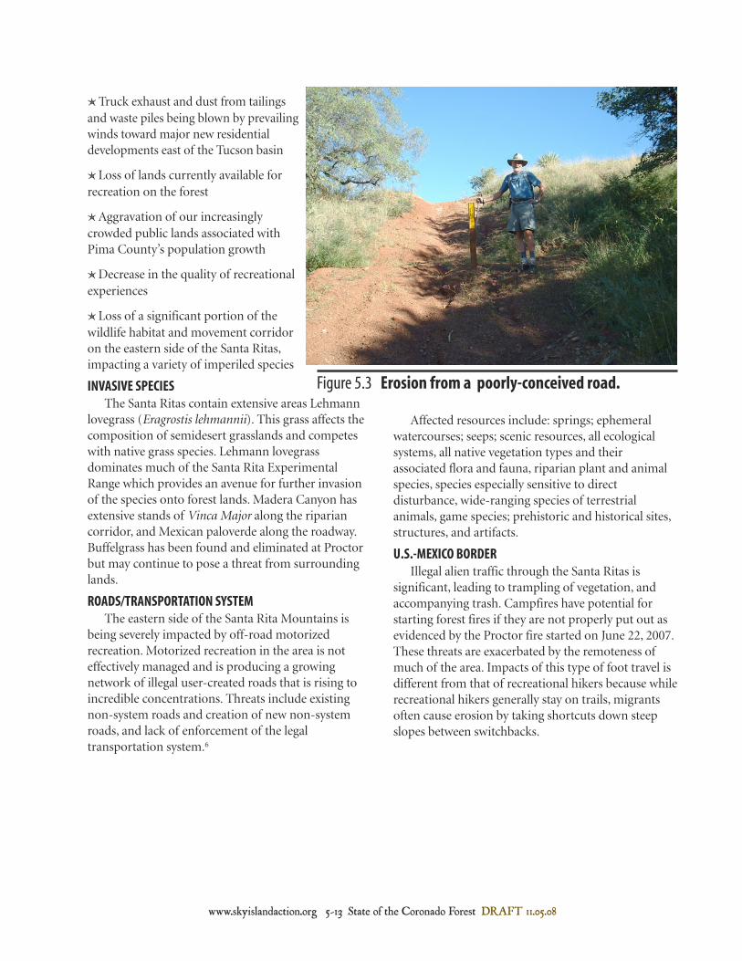
ROADS/TRANSPORTATION SYSTEMThe eastern side of the Santa Rita Mountains is
being severely impacted by off-road motorizedrecreation. Motorized recreation in the area is noteffectively managed and is producing a growingnetwork of illegal user-created roads that is rising toincredible concentrations. Threats include existingnon-system roads and creation of new non-systemroads, and lack of enforcement of the legaltransportation system.6
Affected resources include: springs; ephemeralwatercourses; seeps; scenic resources, all ecologicalsystems, all native vegetation types and theirassociated flora and fauna, riparian plant and animalspecies, species especially sensitive to directdisturbance, wide-ranging species of terrestrialanimals, game species; prehistoric and historical sites,structures, and artifacts.
U.S.-MEXICO BORDERIllegal alien traffic through the Santa Ritas is
significant, leading to trampling of vegetation, andaccompanying trash. Campfires have potential forstarting forest fires if they are not properly put out asevidenced by the Proctor fire started on June 22, 2007.These threats are exacerbated by the remoteness ofmuch of the area. Impacts of this type of foot travel isdifferent from that of recreational hikers because whilerecreational hikers generally stay on trails, migrantsoften cause erosion by taking shortcuts down steepslopes between switchbacks.
Figure 5.3 Erosion from a poorly-conceived road.

DRAFT 11.05.08 State of the Coronado Forest 5-14 www.skyislandaction.org
Designate Madera Canyon as a "no collecting area."
Implement wildland fire use for restoring historical fire patterns and forrestoring natural vegetation characteristics.
Use prescribed and naturally ignited fire, and mechanical thinning, as tools tochange or maintain natural vegetative structure in Apachean Grassland andSavanna, Madrean Pine-Oak Woodland and Madrean Encinal.
Restore and maintain natural disturbance regimes (e.g., fire, flood), in amanner that promotes naturally functioning ecosystem processes.
Restore Madrean Pine-Oak Woodland and Madrean Encinal to resilientecological systems that tolerate wildfire, flood and other natural influences.
Restore and maintain natural vegetative characteristics and vegetativediversity.
Prevent catastrophic stand-replacing wildfires.
Maintain the watershed health and function of watersheds in the Santa RitaEMA.
Ecological Restoration
Objectives Actions
Foster public-private partnerships that will lead to landscape-levelconservation through coordination of land use across Forest boundaries.
Encourage and appreciate good stewardship among private landowners onholdings adjacent to the Forest.
Maintain wildlife corridors between the Santa Rita EMA and the TumacacoriEMA, the Huachuca EMA, the Whetstone EMA and other surrounding naturalareas.
Maintain the ecological integrity of the Santa Rita EMA in the face of furtherdevelopment of the surrounding lands and increased visitor use.
Adjacent Land Uses
Objectives Actions
Nonextractive Uses
Objectives ActionsManage dispersed camping during hunting season in order to preventecological damage in the areas of Proctor Road, Gardener Canyon Road, Mt.Hopkins Road, Box Canyon Road, Casa Blanca and Adobe Canyon Road andother areas of high use.
Restore historical native wildlife diversity.
Manage habitat for all wild, native species so that they persist over largescales of time and space.
Recreational Planning
Minimize wildlife disturbance due to recreational uses of the Forest.
Minimize damage to natural and cultural resources due to recreational usesof the Forest.
The Santa Rita Ecosystem Management Area(EMA) is a biological gem of the Coronado NationalForest. It is known for the outstanding birdingopportunities found in Madera Canyon andsurrounding areas. This type of recognition andappreciation adds to the ecological sustainability ofthe area along with the economic sustainability of theregion and should be a major consideration inmanagement of the area. The range still offers greatopportunities for primitive recreation where quiet andsolitude can be experienced. This should be a major
focus and driver for future management of this area.New management direction that shows foresight andproactively addresses threats will create a long-termframework for ecological health and sustainability inthe Santa Rita EMA. To confront threats and capitalizeon conservation assets, we recommend the followingobjectives and management actions to beincorporated into the revision of the CoronadoNational Forest Plan and subsequent project levelactivities.
Recommended Objectives and Management Actions
www.skyislandaction.org 5-15 State of the Coronado Forest DRAFT 11.05.08
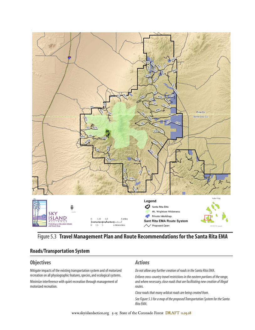
Figure 5.3 Travel Management Plan and Route Recommendations for the Santa Rita EMA
Do not allow any further creation of roads in the Santa Rita EMA.
Enforce cross-country travel restrictions in the eastern portions of the range,and where necessary, close roads that are facilitating new creation of illegalroutes.
Close roads that many wildcat roads are being created from.
See Figure 5.3 for a map of the proposed Transportation System for the SantaRita EMA.
Mitigate impacts of the existing transportation system and of motorizedrecreation on all physiographic features, species, and ecological systems.
Minimize interference with quiet recreation through management ofmotorized recreation.
Roads/Transportation System
Objectives Actions

DRAFT 11.05.08 State of the Coronado Forest 5-16 www.skyislandaction.org
Mount Wrightson Wilderness AreaMount Wrightson, a spectacular peak visible from
miles around, rises to 9,452 feet of elevation at theheart of the Mount Wrightson Wilderness. The 25,260acres of Mount Wrightson Wilderness also includesthe prominent peak of Mt. Hopkins and all of theSanta Rita Crest. The Wilderness encompasses rough
hillsides, deep canyons, and lofty peaks, surroundedby semiarid hillsides and sloping grasslands. Douglasfir, Gambel oak, Limber pine, Apache pine andPonderosa pine dominate high elevations in the areaand stream-fed canyons support an abundance ofplant and animal life. Several remnant stands ofquaking aspen also occur here.
SPECIAL INTEREST AREASSpecial Interest Areas are special management
areas designated to protect unique botanical,zoological, geological, cultural, or scenic values. Theymay also be designated to protect and managesensitive species or other elements of biologicaldiversity. These areas are managed to protect theunique elements for which they were designated whileproviding appropriate public education andrecreational opportunities. These areas help the ForestService to maintain ecological and socialsustainability. The rich cultural heritage of the SantaRita Mountains warrants the designation of RosemontValley Historical Area as a Special Interest Area.
Proposed Rosemont Valley Historical AreaRosemont Valley was inhabited and utilized by pre-
historic cultures and Native Americans, by Spanishand Mexican settlers during the Spanish territorialperiod, and then by Anglo ranchers, loggers andminers. The area is rich in built structures andphysical sites of cultural importance.
NAME: Rosemont Valley Historic Area
SIZE: Approximately 14,000 acres.
BOUNDARIES: This Historic Area includesRosemont Junction, Rosemont Ranch and BarrelCanyon which drains directly into Davidson Canyon,and the town of Helvetia. It extends from the crest ofthe mountains, and slopes down to the west throughthe historic mining town of Helvetia, to the eastthrough Rosemont Junction to the National Forestboundary, to Mount Fagan to the north, and to BoxCanyon Road to the south.
ELEVATION: Approximately 4,400 to 6,300 feet.
GENERAL DESCRIPTION OF AREA: This Historic Areaincludes rolling hills of oak studded grasslands,numerous perennial springs, and rugged cliffs. It is abiologically rich area with numerous perennial waters,which accounts for its long human occupation.
CURRENT USES: This area is currently used forwildlife viewing, mountain bike riding, dirt bike andquad riding, hiking, camping, ranching and hunting.
JUSTIFICATION FOR DESIGNATION: In the 1970sdetailed cultural inventories were conducted for theAnamax Mining Company. Approximately 621 sites
Wilderness
Correct existing maps of boundaries of inventoried roadless areas to reflect thetrue boundaries on the ground.
Manage 65,397 acres of the Santa Rita EMA to maintain their currentwilderness suitability. See Figure 5.4 for a map of the area to be managed forwilderness suitability.
Protect Roadless area values and characteristics.
Provide opportunities for quiet recreation on the Santa Rita EMA.
Minimize habitat fragmentation and degradation, and maintain biologicalcorridors and essential habitat for species through the exclusion of roads.
Adequately consider the suitability of national forest system lands forinclusion in the National Wilderness Preservation System.
Special Management Areas
Objectives Actions
Special Management Areas

www.skyislandaction.org 5-17 State of the Coronado Forest DRAFT 11.05.08
Figure 5.4 Area Suitable for Wilderness and to be Managed for Wilderness Characteristics

DRAFT 11.05.08 State of the Coronado Forest 5-18 www.skyislandaction.org
1 Stefferud, J. A. and S. E. Stefferud. 2004. Aquaticand Riparian Surveys of Selected Stream Courses onSierra Vista and Nogales Ranger Districts, CoronadoNational Forest, Cochise and Santa Cruz Counties,Arizona. Arizona State University, Tempe, Arizona.
2 Federal Register. 62 FR 49025.
3 Wilson, J. P. 1995. Islands in the Desert. A Historyof the Uplands of Southeastern Arizona. University ofNew Mexico Press, Albuquerque New Mexico.
4 Marshall, R.M., D. Turner, A. Gondor, D. Gori, C.Enquist, G. Luna, R. Paredes Aguilar, S. Anderson, S.Schwartz, C. Watts, E. Lopez, P. Comer. 2004. An
Ecological Analysis of Conservation Priorities in theApache Highlands Ecoregion. Prepared by The NatureConservancy of Arizona, Instituto del MedioAmbiente y el Desarrollo Sustentable del Estado deSonora, agency and institutional partners. 152 pp.
4 Davis, Tony. "Game and Fish is Harsh inRosemont Opposition." The Arizona Daily Star. July21, 2008.
6 All of the impacts listed for this threat come fromTrombulak, S. C., and C. Frissell. 2000. Review ofecological effects of roads on terrestrial and aquaticecosystems. Conservation Biology 14; 18-30.
were identified and recorded, ranging in time from thelate Pleistocene, Archaic, Hohokam, Early Piman,Spanish, Mexican, and American Territorial periods(10,000 B.C. to the present). Most of these sites reflectNative American use and occupation over manythousands of years, while only 30 sites date to thehistoric period or the last 300 years. Notable historicsites include a number of mines, camps, mills, and themining towns of Helvetia, Old Rosemont, and NewRosemont, and the VR Ranch established by EdwardVail in 1883, which is today the headquarters ofRosemont Ranch (see Pima County’s “Preserving theSanta Rita Rosemont Ranch” 2004 report on this areafor more details). Due to its past mining history, thearea contains a well developed network of dirt roads
which are used primarily for road-based recreationPersonal observance of this use over the yearsindicates that recreationists tend to stay on the roads.
RECOMMENDATIONS FOR FUTURE USE: Culturalpreservation should be a priority for this area. Allexisting uses should continue to be permitted,however the most sensitive cultural sites should beprotected. My recommendation for this area would beto identify and protect these most sensitive siteswithout drawing attention to them (to preventvandalism). In addition, a few informational signsmay be placed at the existing off-road vehicle stagingareas along with the other forest use notices.
PROPOSED BY: Lainie Levick, Hydrologist, University of Arizona